

Nantahala National Forest
Encyclopedia
United States
The United States of America is a federal constitutional republic comprising fifty states and a federal district...
state of North Carolina
North Carolina
North Carolina is a state located in the southeastern United States. The state borders South Carolina and Georgia to the south, Tennessee to the west and Virginia to the north. North Carolina contains 100 counties. Its capital is Raleigh, and its largest city is Charlotte...
. The word "Nantahala" is a Cherokee
Cherokee language
Cherokee is an Iroquoian language spoken by the Cherokee people which uses a unique syllabary writing system. It is the only Southern Iroquoian language that remains spoken. Cherokee is a polysynthetic language.-North American etymology:...
word meaning "Land of the Noonday Sun." The name is appropriate as, in some spots, the sun only reaches the floors of the deep gorges of the national forest when directly overhead at midday. The Spanish Conquistador
Conquistador
Conquistadors were Spanish soldiers, explorers, and adventurers who brought much of the Americas under the control of Spain in the 15th to 16th centuries, following Europe's discovery of the New World by Christopher Columbus in 1492...
Hernando de Soto
Hernando de Soto (explorer)
Hernando de Soto was a Spanish explorer and conquistador who, while leading the first European expedition deep into the territory of the modern-day United States, was the first European documented to have crossed the Mississippi River....
explored the area in 1540, as did William Bartram
William Bartram
William Bartram was an American naturalist. The son of Ann and John Bartram, William Bartram and his twin sister Elizabeth were born in Kingsessing, Pennsylvania, near Philadelphia. As a boy, he accompanied his father on many of his travels, to the Catskill Mountains, the New Jersey Pine Barrens,...
in the 18th century. The Nantahala National Forest is home to the famous Nantahala River
Nantahala River
The Nantahala River is a river in western North Carolina in the United States, within the Nantahala National Forest, and near the Great Smoky Mountains National Park. Two-lane U.S...
.
The Nantahala National Forest is administered by the United States Forest Service
United States Forest Service
The United States Forest Service is an agency of the United States Department of Agriculture that administers the nation's 155 national forests and 20 national grasslands, which encompass...
, part of the United States Department of Agriculture
United States Department of Agriculture
The United States Department of Agriculture is the United States federal executive department responsible for developing and executing U.S. federal government policy on farming, agriculture, and food...
. The forest is managed together with the other three North Carolina National Forests (Croatan
Croatan National Forest
The Croatan National Forest is a U.S. National Forest, was established on July 29, 1936, and is located on the Atlantic coast of North Carolina. It is administered by the United States Forest Service, a part of the United States Department of Agriculture...
, Pisgah
Pisgah National Forest
Pisgah National Forest is a National Forest in the Appalachian Mountains of western North Carolina. It is administered by the United States Forest Service, part of the United States Department of Agriculture. The Pisgah National Forest is completely contained within the state of North Carolina...
, and Uwharrie
Uwharrie National Forest
Uwharrie National Forest is a federally-designated national forest region located primarily in Montgomery County, but also extending into Randolph and Davidson counties in south central North Carolina. It is the smallest of the four National Forests in North Carolina, with a total area of 50,369...
) from common headquarters in Asheville, North Carolina
Asheville, North Carolina
Asheville is a city in and the county seat of Buncombe County, North Carolina, United States. It is the largest city in Western North Carolina, and the 11th largest city in North Carolina. The City is home to the United States National Climatic Data Center , which is the world's largest active...
.
Overview
Nantahala National Forest is the largest of the four national forests in North CarolinaNorth Carolina
North Carolina is a state located in the southeastern United States. The state borders South Carolina and Georgia to the south, Tennessee to the west and Virginia to the north. North Carolina contains 100 counties. Its capital is Raleigh, and its largest city is Charlotte...
, lying in the mountains and valleys of western North Carolina. The terrain varies in elevation from 5800 feet (1,767.8 m) at Lone Bald in Jackson County
Jackson County, North Carolina
Jackson County is a county located in the southwest of the U.S. state of North Carolina. As of 2010, the population was 40,271. Since 1913 its county seat has been Sylva, replacing Webster.-History:...
, to 1200 feet (365.8 m) in Cherokee County
Cherokee County, North Carolina
- Transportation :Cherokee County is well known in North Carolina as the westernmost of the state's 100 counties. Several US and state highways serve the county, linking it with other regions of North Carolina, along with the neighboring states of Georgia and Tennessee.US 64 - the longest highway...
along the Hiwassee River
Hiwassee River
The Hiwassee River has its headwaters on the north slope of Rocky Mountain in Towns County in northern Georgia and flows northward into North Carolina before turning westward into Tennessee, flowing into the Tennessee River a few miles west of State Route 58 in Meigs County, Tennessee...
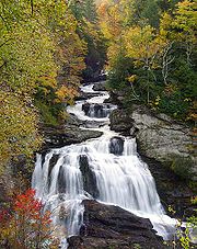
below the Appalachian Dam. It is the home of many western NC waterfalls. The last part of the Mountain Waters Scenic Byway
Mountain Waters Scenic Byway
The Mountain Waters Scenic Byway is a two-lane highway in North Carolina, which travels through the Nantahala National Forest in Macon and Swain County, North Carolina counties. The first part of this byway follows the combined route of U.S...
travels through this forest. The total area under management is 531286 acre (830.14 sq mi; 2,150.04 km²). In descending order of land area it is located in parts of Macon
Macon County, North Carolina
- Geographic features :Of the in Macon County, are federal lands that lie within the Nantahala National Forest and are administered by the United States Forest Service. Of the of USFS land, lie in the Highlands Ranger District and the remaining lie in the Wayah Ranger District...
, Graham
Graham County, North Carolina
-Demographics:As of the census of 2000, there were 7,993 people, 3,354 households, and 2,411 families residing in the county. The population density was 27 people per square mile . There were 5,084 housing units at an average density of 17 per square mile...
, Cherokee
Cherokee County, North Carolina
- Transportation :Cherokee County is well known in North Carolina as the westernmost of the state's 100 counties. Several US and state highways serve the county, linking it with other regions of North Carolina, along with the neighboring states of Georgia and Tennessee.US 64 - the longest highway...
, Jackson
Jackson County, North Carolina
Jackson County is a county located in the southwest of the U.S. state of North Carolina. As of 2010, the population was 40,271. Since 1913 its county seat has been Sylva, replacing Webster.-History:...
, Clay
Clay County, North Carolina
-Communities and Townships:Hayesville, with a 2000 population of 297, is the only incorporated town in the county, the county seat, and center of economic activity for Clay County...
, Swain
Swain County, North Carolina
Swain County is a county located in the U.S. state of North Carolina. As of 2000, the population was 12,968. Its county seat is Bryson City.Swain County is home of the Nantahala River . The Nantahala is one of the most popular whitewater rafting rivers in the nation...
, and Transylvania
Transylvania County, North Carolina
Transylvania County is a county located in the U.S. state of North Carolina. As of 2010, the population was 33,090. Its county seat is Brevard.- History :The county was formed in 1861 from parts of Henderson County and Jackson County...
counties.
The town Murphy is right in the middle of the Nantahala Forest
Organization
Nantahala National Forest is divided into three range Districts: the Highlands (now Nantahala Ranger District) Ranger District (now consolidated with the Wayah Ranger District), the Tusquitee Ranger District, the Cheoah Ranger District, and the Nantahala Ranger District.
Macon County, North Carolina
- Geographic features :Of the in Macon County, are federal lands that lie within the Nantahala National Forest and are administered by the United States Forest Service. Of the of USFS land, lie in the Highlands Ranger District and the remaining lie in the Wayah Ranger District...
, Jackson
Jackson County, North Carolina
Jackson County is a county located in the southwest of the U.S. state of North Carolina. As of 2010, the population was 40,271. Since 1913 its county seat has been Sylva, replacing Webster.-History:...
and Transylvania
Transylvania County, North Carolina
Transylvania County is a county located in the U.S. state of North Carolina. As of 2010, the population was 33,090. Its county seat is Brevard.- History :The county was formed in 1861 from parts of Henderson County and Jackson County...
counties.This district contains the 40000 acre (62.5 sq mi; 161.9 km²) Roy Taylor Forest located in Jackson County, southwest of and adjacent to the Blue Ridge Parkway
Blue Ridge Parkway
The Blue Ridge Parkway is a National Parkway and All-American Road in the United States, noted for its scenic beauty. It runs for 469 miles , mostly along the famous Blue Ridge, a major mountain chain that is part of the Appalachian Mountains...
, that it acquired in 1981. The rugged and scenic Tuckasegee Gorge is within the Roy Taylor Forest.This district is headquartered in Highlands, North Carolina
Highlands, North Carolina
Highlands is an incorporated town in Macon County in the U.S. state of North Carolina. Located on a plateau in the southern Appalachian Mountains, within the Nantahala National Forest, it lies mostly in southeastern Macon County and slightly in southwestern Jackson County, in the Highlands and...
. This ranger district was consolidated with the Wayah Ranger District in 2006 to form the Nantahala Ranger District. This ranger district is now headquartered in Franklin, NC. This makes the consolidated district now the largest.
The 158348 acre (247.4 sq mi; 640.8 km²) Tusquitee Ranger District is no longer the largest district and is located in Cherokee and Clay County, Clay
Clay County, North Carolina
-Communities and Townships:Hayesville, with a 2000 population of 297, is the only incorporated town in the county, the county seat, and center of economic activity for Clay County...
and Graham
Graham County, North Carolina
-Demographics:As of the census of 2000, there were 7,993 people, 3,354 households, and 2,411 families residing in the county. The population density was 27 people per square mile . There were 5,084 housing units at an average density of 17 per square mile...
counties as well. The district's features include the Hiawassee River, Jackrabbit Mountain as well as Lake Chatuge, Lake Hiawassee, Lake Appalachia. All the lakes on or bordering the Tusquitee Ranger
District are managed by TVA
Tennessee Valley Authority
The Tennessee Valley Authority is a federally owned corporation in the United States created by congressional charter in May 1933 to provide navigation, flood control, electricity generation, fertilizer manufacturing, and economic development in the Tennessee Valley, a region particularly affected...
. Tusquitee is Cherokee for "where the water dogs laughed." The highest point on the district is Tusquitee Bald (5280 feet (1,609 m)) located in Clay County. This Tusquitee Ranger District is headquartered in Murphy, North Carolina
Murphy, North Carolina
-Household Income:The median income for a household in the town was $24,952, and the median income for a family was $35,234. Males had a median income of $30,395 versus $16,908 for females. The per capita income for the town was $16,926...
.
The Cheoah Ranger District has 120110 acre (187.7 sq mi; 486.1 km²) in Graham and Swain counties. These lands adjoin four large mountain reservoirs and contain numerous streams. Cheoah is the Cherokee word for "otter." The Appalachian Trail
Appalachian Trail
The Appalachian National Scenic Trail, generally known as the Appalachian Trail or simply the AT, is a marked hiking trail in the eastern United States extending between Springer Mountain in Georgia and Mount Katahdin in Maine. It is approximately long...
winds through the Cheoah Ranger District after leaving the Nantahala Ranger District on its way to the Great Smoky Mountains National Park
Great Smoky Mountains National Park
Great Smoky Mountains National Park is a United States National Park and UNESCO World Heritage Site that straddles the ridgeline of the Great Smoky Mountains, part of the Blue Ridge Mountains, which are a division of the larger Appalachian Mountain chain. The border between Tennessee and North...
. This district's features includes the Joyce Kilmer Memorial Forest and part of the Joyce Kilmer-Slickrock Wilderness
Joyce Kilmer-Slickrock Wilderness
Joyce Kilmer-Slickrock Wilderness, created in 1975, covers in the Nantahala National Forest in western North Carolina and the Cherokee National Forest in eastern Tennessee, in the watersheds of the Slickrock and Little Santeetlah Creeks...
and is headquartered in Robbinsville, North Carolina
Robbinsville, North Carolina
Robbinsville is a town in Graham County, North Carolina, United States. The population was 747 at the 2000 census. It is the county seat of Graham County. Robbinsville High School is the only high school in Graham County...
.
The Wayah Ranger District (Now named Nantahala Ranger District), named after the Cherokee Indian word meaning "wolf," contains 133894 acre (209.2 sq mi; 541.9 km²) adjacent to the Cherokee Indian Reservation
Eastern Band of Cherokee Indians
The Eastern Band of Cherokee Indians , is a federally recognized Native American tribe in the United States of America, who are descended from Cherokee who remained in the Eastern United States while others moved, or were forced to relocate, to the west in the 19th century. The history of the...
in Macon, Swain
Swain County, North Carolina
Swain County is a county located in the U.S. state of North Carolina. As of 2000, the population was 12,968. Its county seat is Bryson City.Swain County is home of the Nantahala River . The Nantahala is one of the most popular whitewater rafting rivers in the nation...
, and Jackson counties. The district is headquartered in Franklin, North Carolina
Franklin, North Carolina
Franklin is a town in Franklin Township, Macon County, North Carolina, United States, within the Nantahala National Forest. The population was 3,490 as of the 2000 census. It is the county seat of Macon County. Franklin is an official Appalachian Trail friendly destination...
. The Appalachian Trail
Appalachian Trail
The Appalachian National Scenic Trail, generally known as the Appalachian Trail or simply the AT, is a marked hiking trail in the eastern United States extending between Springer Mountain in Georgia and Mount Katahdin in Maine. It is approximately long...
enters the Wayah Ranger District from Georgia
Georgia (U.S. state)
Georgia is a state located in the southeastern United States. It was established in 1732, the last of the original Thirteen Colonies. The state is named after King George II of Great Britain. Georgia was the fourth state to ratify the United States Constitution, on January 2, 1788...
. This district's features include the 5499 feet (1,676.1 m) Standing Indian Mountain
Standing Indian Mountain
Standing Indian Mountain, elevation 5,499 feet, is part of the North Carolina portion of the Southern Nantahala Wilderness within the boundaries of the Nantahala National Forest...
, the Nantahala Gorge and Wayah Bald
Wayah Bald
Wayah Bald is a high-altitude treeless open area in Nantahala National Forest, near Franklin, North Carolina. The Wayah Bald Observation Tower is located at the area's highest point ; the stone observation tower was built by the Civilian Conservation Corps in 1937 for fire detection.The...
.
Three Wilderness
Wilderness
Wilderness or wildland is a natural environment on Earth that has not been significantly modified by human activity. It may also be defined as: "The most intact, undisturbed wild natural areas left on our planet—those last truly wild places that humans do not control and have not developed with...
areas are located within the Nantahala National Forest. Ellicott Rock Wilderness is located near Highland, North Carolina at the intersection of North Carolina, South Carolina and Georgia, with 3,900 acres (16 km²) in the North Carolina portion. The Southern Nantahala Wilderness
Southern Nantahala Wilderness
The Southern Nantahala Wilderness was designated in 1984 and currently consists of . Approximately are located in Georgia in the Chattahoochee National Forest and approximately are located in North Carolina in the Nantahala National Forest. The Wilderness is managed by the United States Forest...
includes 10900 acre (17 sq mi; 44.1 km²) in the North Carolina portion and lies in the Tusquitee and Wayah Ranger Districts. Joyce Kilmer-Slickrock Wilderness
Joyce Kilmer-Slickrock Wilderness
Joyce Kilmer-Slickrock Wilderness, created in 1975, covers in the Nantahala National Forest in western North Carolina and the Cherokee National Forest in eastern Tennessee, in the watersheds of the Slickrock and Little Santeetlah Creeks...
which includes another 13100 acres (53 km²) in North Carolina. These wilderness areas provide an opportunity for solitude in a rugged, natural setting. The Forest manages two Off - Highway Vehicle areas. The most famous being Tellico OHV area located on the Tusquitee Ranger District an additional OHV areas is located on the Highlands Ranger District (Nantahala Ranger District). Many miles of trout water exist on the forest.
The Joyce Kilmer Memorial Forest within the National Forest was dedicated on July 30, 1936 to poet Joyce Kilmer
Joyce Kilmer
Alfred Joyce Kilmer was an American journalist, poet, literary critic, lecturer, and editor. Though a prolific poet whose works celebrated the common beauty of the natural world as well as his religious faith, Kilmer is remembered most for a short poem entitled "Trees" , which was published in...
.
Forests and old growth
Several areas of old-growth forest have been identified in the Nantahala National Forest, totaling some 30800 acres (124.6 km²). The Joyce Kilmer Wilderness in particular contains nearly 6000 acres (24.3 km²) of old-growth forest.See also
- List of U.S. national forests
- List of U.S. state forests
- Federal landsFederal landsFederal lands are lands in the United States for which ownership is claimed by the U.S. federal government.-Primary federal land holders:*Bureau of Land Management*United States Forest Service*United States Fish and Wildlife Service*National Park Service...
- National Forest Management Act of 1976National Forest Management Act of 1976The National Forest Management Act of 1976 is a United States federal law that is the primary statute governing the administration of national forests and was an amendment to the Forest and Rangeland Renewable Resources Planning Act of 1974, which called for the management of renewable resources...