

Pisgah National Forest
Encyclopedia

United States National Forest
National Forest is a classification of federal lands in the United States.National Forests are largely forest and woodland areas owned by the federal government and managed by the United States Forest Service, part of the United States Department of Agriculture. Land management of these areas...
in the Appalachian Mountains
Appalachian Mountains
The Appalachian Mountains #Whether the stressed vowel is or ,#Whether the "ch" is pronounced as a fricative or an affricate , and#Whether the final vowel is the monophthong or the diphthong .), often called the Appalachians, are a system of mountains in eastern North America. The Appalachians...
of western North Carolina
North Carolina
North Carolina is a state located in the southeastern United States. The state borders South Carolina and Georgia to the south, Tennessee to the west and Virginia to the north. North Carolina contains 100 counties. Its capital is Raleigh, and its largest city is Charlotte...
. It is administered by the United States Forest Service
United States Forest Service
The United States Forest Service is an agency of the United States Department of Agriculture that administers the nation's 155 national forests and 20 national grasslands, which encompass...
, part of the United States Department of Agriculture
United States Department of Agriculture
The United States Department of Agriculture is the United States federal executive department responsible for developing and executing U.S. federal government policy on farming, agriculture, and food...
. The Pisgah National Forest is completely contained within the state of North Carolina. The forest is managed together with the other three North Carolina National Forests (Croatan
Croatan National Forest
The Croatan National Forest is a U.S. National Forest, was established on July 29, 1936, and is located on the Atlantic coast of North Carolina. It is administered by the United States Forest Service, a part of the United States Department of Agriculture...
, Nantahala
Nantahala National Forest
The Nantahala National Forest, established in 1920, is a national forest located in the American state of North Carolina. The word "Nantahala" is a Cherokee word meaning "Land of the Noonday Sun." The name is appropriate as, in some spots, the sun only reaches the floors of the deep gorges of the...
, and Uwharrie
Uwharrie National Forest
Uwharrie National Forest is a federally-designated national forest region located primarily in Montgomery County, but also extending into Randolph and Davidson counties in south central North Carolina. It is the smallest of the four National Forests in North Carolina, with a total area of 50,369...
) from common headquarters in Asheville, North Carolina
Asheville, North Carolina
Asheville is a city in and the county seat of Buncombe County, North Carolina, United States. It is the largest city in Western North Carolina, and the 11th largest city in North Carolina. The City is home to the United States National Climatic Data Center , which is the world's largest active...
. There are local ranger district
Park ranger
A park ranger or forest ranger is a person entrusted with protecting and preserving parklands – national, state, provincial, or local parks. Different countries use different names for the position. Ranger is the favored term in the United States, Canada, and the United Kingdom. Within the United...
offices located in Pisgah Forest
Pisgah Forest, North Carolina
Pisgah Forest is an unincorporated community in Transylvania County, North Carolina, United States. It sits at an elevation of 2100 feet along U.S. Route 64, northeast of Brevard. It is approximately a 30 minute drive from the Asheville Airport. The community lies in an area noted for its many...
, Burnsville
Burnsville, North Carolina
Burnsville is a town in Yancey County, North Carolina, United States. The population was 1,623 at the 2000 census. It is the county seat of Yancey County.-Geography:Burnsville is located at ....
, and Nebo
Nebo, North Carolina
Nebo is an unincorporated community in the Nebo Township of eastern McDowell County, North Carolina. The zip code is 28761.- History :Nebo is named after a Methodist campground that existed before the Civil War...
.
Geography
Appalachian Mountains
The Appalachian Mountains #Whether the stressed vowel is or ,#Whether the "ch" is pronounced as a fricative or an affricate , and#Whether the final vowel is the monophthong or the diphthong .), often called the Appalachians, are a system of mountains in eastern North America. The Appalachians...
, including parts of the Blue Ridge Mountains
Blue Ridge Mountains
The Blue Ridge Mountains are a physiographic province of the larger Appalachian Mountains range. This province consists of northern and southern physiographic regions, which divide near the Roanoke River gap. The mountain range is located in the eastern United States, starting at its southern-most...
and Great Balsam Mountains
Great Balsam Mountains
The Great Balsam Mountains, or Balsam Mountains, are in the mountain region of western North Carolina, United States. The Great Balsams are a subrange of the Blue Ridge Mountains, which in turn are a part of the Appalachian Mountains...
. Elevations reach over 6000 feet (1,828.8 m) and include some of the highest mountains in the eastern United States. Mount Mitchell
Mount Mitchell (North Carolina)
Mount Mitchell is the highest peak of the Appalachian Mountains and the highest peak in the eastern United States. It was the highest point in any state of the United States until Texas joined the union in 1845. The nearest higher point east of the Rocky Mountains is Harney Peak in the Black Hills...
, in Mount Mitchell State Park
Mount Mitchell State Park
Mount Mitchell State Park is a North Carolina state park in Yancey County, North Carolina in the United States. Established in 1915 by the state legislature, it became the first state park of North Carolina...
, is the highest mountain east of the Mississippi River
Mississippi River
The Mississippi River is the largest river system in North America. Flowing entirely in the United States, this river rises in western Minnesota and meanders slowly southwards for to the Mississippi River Delta at the Gulf of Mexico. With its many tributaries, the Mississippi's watershed drains...
and lies just outside the boundary of Pisgah National Forest. The forest also includes tracts surrounding the city of Asheville
Asheville, North Carolina
Asheville is a city in and the county seat of Buncombe County, North Carolina, United States. It is the largest city in Western North Carolina, and the 11th largest city in North Carolina. The City is home to the United States National Climatic Data Center , which is the world's largest active...
, the city of Brevard
Brevard, North Carolina
Brevard is a town in Transylvania County, North Carolina, United States. The 2005 population estimate by the United States Census Bureau was 6,643. It is the county seat of Transylvania County....
and land in the French Broad River
French Broad River
The French Broad River flows from near the village of Rosman in Transylvania County, North Carolina, into the state of Tennessee. Its confluence with the Holston River at Knoxville is the beginning of the Tennessee River....
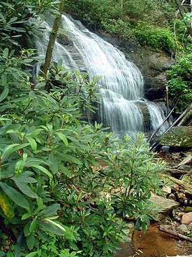
Valley. Recreational opportunities include hiking
Hiking
Hiking is an outdoor activity which consists of walking in natural environments, often in mountainous or other scenic terrain. People often hike on hiking trails. It is such a popular activity that there are numerous hiking organizations worldwide. The health benefits of different types of hiking...
and backpacking
Backpacking (wilderness)
Backpacking combines the activities of hiking and camping for an overnight stay in backcountry wilderness...
, among others. The land and its resources are also used for hunting
Hunting
Hunting is the practice of pursuing any living thing, usually wildlife, for food, recreation, or trade. In present-day use, the term refers to lawful hunting, as distinguished from poaching, which is the killing, trapping or capture of the hunted species contrary to applicable law...
, wildlife management, and timber
Timber
Timber may refer to:* Timber, a term common in the United Kingdom and Australia for wood materials * Timber, Oregon, an unincorporated community in the U.S...
harvesting, as well as the North Carolina Arboretum
North Carolina Arboretum
The North Carolina Arboretum is an arboretum and botanical garden located within the Bent Creek Experimental Forest of the Pisgah National Forest at 100 Frederick Law Olmsted Way, southwest of Asheville, North Carolina near the Blue Ridge Parkway. It is open daily except for Christmas Day...
. The forest lies in parts of 12 counties in western North Carolina. In descending order they are Transylvania
Transylvania County, North Carolina
Transylvania County is a county located in the U.S. state of North Carolina. As of 2010, the population was 33,090. Its county seat is Brevard.- History :The county was formed in 1861 from parts of Henderson County and Jackson County...
, McDowell
McDowell County, North Carolina
-Cities and towns:*Marion *Old Fort-Unincorporated places:*West Marion*Little Switzerland*Nebo*Glenwood*Pleasant Gardens*North Cove-Education:The following is a list of schools located in McDowell County:*Marion Elementary School...
, Haywood
Haywood County, North Carolina
-National protected areas:* Blue Ridge Parkway * Great Smoky Mountains National Park * Pisgah National Forest -Major Highways & Roads:* Interstate 40* U.S. Highway 19* U.S. Highway 23* U.S. Highway 74* U.S...
, Madison
Madison County, North Carolina
-Demographics:As of the census of 2000, there were 19,635 people, 8,000 households, and 5,592 families residing in the county. The population density was 44 people per square mile . There were 9,722 housing units at an average density of 22 per square mile...
, Caldwell
Caldwell County, North Carolina
-Demographics:As of the census of 2000, there were 77,415 people, 30,768 households, and 22,399 families residing in the county. The population density was 164 people per square mile . There were 33,430 housing units at an average density of 71 per square mile...
, Burke
Burke County, North Carolina
-Demographics:As of the census of 2000, there were 89,148 people, 34,528 households, and 24,342 families residing in the county. The population density was 176 people per square mile . There were 37,427 housing units at an average density of 74 per square mile...
, Yancey
Yancey County, North Carolina
-Demographics:As of the census of 2000, there were 17,774 people, 7,472 households, and 5,372 families residing in the county. The population density was 57 people per square mile . There were 9,729 housing units at an average density of 31 per square mile...
, Buncombe
Buncombe County, North Carolina
-Demographics:As of the census of 2000, there were 206,330 people, 85,776 households, and 55,668 families residing in the county. The population density was 314 people per square mile . There were 93,973 housing units at an average density of 143 per square mile...
, Avery
Avery County, North Carolina
- Climate :As a result of its relatively high elevation, Avery County has a Humid continental climate enjoying considerably cooler summers than most of the rest of the Eastern US. Likewise, winters are longer, colder and snowier than most other locations in the region. This can be evidenced by the...
, Mitchell
Mitchell County, North Carolina
-National protected areas:* Blue Ridge Parkway * Pisgah National Forest -Demographics:As of the census of 2000, there were 15,687 people, 6,551 households, and 4,736 families residing in the county. The population density was 71 people per square mile . There were 7,919 housing units at an...
, Henderson
Henderson County, North Carolina
Henderson County is a county located in the U.S. state of North Carolina. It is part of the Asheville, North Carolina, Metropolitan Statistical Area. As of 2008, the population was 102,367. Its county seat is Hendersonville.- History :...
, and Watauga
Watauga County, North Carolina
-Demographics:As of the census of 2000, there were 42,695 people, 16,540 households, and 9,411 families residing in the county. The population density was 137 people per square mile . There were 23,155 housing units at an average density of 74 per square mile...
counties.
Forests and old growth
Some 46600 acres (188.6 km²) of old-growth forests have been identified in the Pisgah National Forest, with 10000 acres (4,046.9 ha) in Linville Gorge.Administration
The Pisgah National Forest is divided into 4 Ranger Districts: the Grandfather, Appalachian, French Broad, and Pisgah districts. The Grandfather and Appalachian Ranger Districts lie in the northern mountains of North Carolina and include areas such as the Linville Gorge WildernessLinville Gorge Wilderness
The Linville Gorge Wilderness is the third largest wilderness area in North Carolina and one of only two wilderness gorges in the Southern United States...
, Wilson Creek
Wilson Creek (North Carolina)
The Wilson Creek area is located in the Grandfather district of the scenic Pisgah National Forest, northwestern section of Caldwell County, North Carolina. Wilson Creek itself is a water system that originates in Calloway Peak and stretches for 23 miles before dumping into John's River. It was...
, the watersheds of the Toe and Cane rivers, Roan Mountain
Roan Mountain (Roan Highlands)
Roan Mountain is the highpoint of the Roan-Unaka Range of the Southern Appalachian Mountains, located in the Southeastern United States. The mountain is clad in a dense stand of Southern Appalachian spruce-fir forest, and includes the world's largest natural rhododendron garden, and the longest...
, Mount Mitchell
Mount Mitchell
Mount Mitchell can refer to:* Mount Mitchell, the highest point in the eastern United States* Mount Mitchell , in Jasper National Park of Canada* Mount Mitchell * Mount Mitchell , in Queensland...
, Craggy Gardens, and the Big Ivy/Coleman Boundary area. The French Broad Ranger District stretches along the Tennessee
Tennessee
Tennessee is a U.S. state located in the Southeastern United States. It has a population of 6,346,105, making it the nation's 17th-largest state by population, and covers , making it the 36th-largest by total land area...
border from the Great Smoky Mountains National Park
Great Smoky Mountains National Park
Great Smoky Mountains National Park is a United States National Park and UNESCO World Heritage Site that straddles the ridgeline of the Great Smoky Mountains, part of the Blue Ridge Mountains, which are a division of the larger Appalachian Mountain chain. The border between Tennessee and North...
north to Hot Springs
Hot Springs, North Carolina
Hot Springs is a town in Madison County, North Carolina, United States. The population was 645 at the 2000 census. It is part of the Asheville Metropolitan Statistical Area.-Geography:Hot Springs is located at ....
.
The Appalachian Trail
Appalachian Trail
The Appalachian National Scenic Trail, generally known as the Appalachian Trail or simply the AT, is a marked hiking trail in the eastern United States extending between Springer Mountain in Georgia and Mount Katahdin in Maine. It is approximately long...
passes through this section of this National Forest.
Rivers and trails
Bent Creek, Mills River, and Davidson River - three major streams and tributaries of the French Broad River - are located in the Pisgah Ranger District, which lies on either side of the Blue Ridge ParkwayBlue Ridge Parkway
The Blue Ridge Parkway is a National Parkway and All-American Road in the United States, noted for its scenic beauty. It runs for 469 miles , mostly along the famous Blue Ridge, a major mountain chain that is part of the Appalachian Mountains...
south of Asheville, along the Pisgah Ridge and Balsam Mountains. Three long-distance recreational trails - the Mountains-to-Sea Trail
Mountains-to-Sea Trail
The Mountains-to-Sea Trail is a long-distance trail, for hiking and backpacking, that runs across North Carolina from the Great Smoky Mountains to the Outer Banks. The trail's western endpoint is at Clingman's Dome, where it connects to the Appalachian Trail in the Great Smoky Mountains National...
, the Shut-In Trail, and the Art Loeb Trail
Art Loeb Trail
The Art Loeb Trail is a trail located in Pisgah National Forest in Western North Carolina. The Northern Terminus is at the Daniel Boone Boy Scout Camp in Haywood County, while the trail's southern Terminus is located near the Davidson River Campground, near Brevard, in Transylvania County...
travel through this district. Also included in the Pisgah Ranger District are the Shining Rock and Middle Prong Wildernesses. The Blue Ridge Parkway
Blue Ridge Parkway
The Blue Ridge Parkway is a National Parkway and All-American Road in the United States, noted for its scenic beauty. It runs for 469 miles , mostly along the famous Blue Ridge, a major mountain chain that is part of the Appalachian Mountains...
transects this National Forest, and many National Forest and Parkway trails intersect.
History

Weeks Act
The Weeks Act is a federal law passed by the US Congress on 1 March 1911 in the United States. The law, introduced by Congressman John W. Weeks of Massachusetts, authorized the Secretary of Agriculture to "Examine, locate and recommend for purchase ... such lands within the watersheds of navigable...
of 1911. While national forests had already been created in the western United States, the Weeks Act provided the authority required to create national forests in the east as well. Although tracts in the future Pisgah National Forest were among the first purchased under the Weeks Act, the very first to receive formal approval was the 31000 acres (125.5 km²) Gennett Purchase in northern Georgia. On March 25, 1921 Boone National Forest
Boone National Forest
Boone National Forest was established by the U.S. Forest Service in North Carolina on January 16, 1920 with . On March 25, 1921 Boone was combined with Pisgah National Forest and the name was discontinued. -External links:*...
was added to Pisgah, and on July 10, 1936, most of Unaka National Forest
Unaka National Forest
Unaka National Forest was established by the U.S. Forest Service in North Carolina, Tennessee and Virginia on July 24, 1920 with . On July 10, 1936 most of the forest was transferred to Pisgah National Forest, with the Virginia portion going to Jefferson National Forest, and the name was discontinued...
was added. In 1954 the Pisgah National Forest was administratively combined with the Croatan
Croatan National Forest
The Croatan National Forest is a U.S. National Forest, was established on July 29, 1936, and is located on the Atlantic coast of North Carolina. It is administered by the United States Forest Service, a part of the United States Department of Agriculture...
and Nantahala
Nantahala National Forest
The Nantahala National Forest, established in 1920, is a national forest located in the American state of North Carolina. The word "Nantahala" is a Cherokee word meaning "Land of the Noonday Sun." The name is appropriate as, in some spots, the sun only reaches the floors of the deep gorges of the...
national forests, collectively known as the National Forests of North Carolina.
American forestry has roots in what is now the Pisgah National Forest. The Cradle of Forestry, (Biltmore Forest School
Biltmore Forest School
The Biltmore School of Forestry was the first school of forestry in North America. The school of "practical forestry" was founded by Carl A. Schenck in 1898 on George W. Vanderbilt's Biltmore Estate near Asheville, North Carolina.-History:...
), located in the southern part of the forest, was the site of the first school of forestry in the United States. It operated during the late 19th and early 20th centuries. The school was opened and operated at the direction of George Washington Vanderbilt II
George Washington Vanderbilt II
George Washington Vanderbilt II was a member of the prominent United States Vanderbilt family, which had amassed a huge fortune through steamboats, railroads, and various business enterprises. He built and owned Biltmore, the largest home in the United States.-Biography:The eighth son and youngest...
, builder of the Biltmore Estate
Biltmore Estate
Biltmore House is a Châteauesque-styled mansion near Asheville, North Carolina, built by George Washington Vanderbilt II between 1889 and 1895. It is the largest privately-owned home in the United States, at and featuring 250 rooms...
in Asheville. The Forestry Education offered at Biltmore was taught by Carl Schenk. A native German Schenk was referred to Vanderbilt when Gifford Pinchot resigned to operate the newly formed Division of Forestry. The Cradle of Forestry and the Biltmore Estate played a major role in the birth of the U.S. Forest Service. Today these lands are part of an educational and recreational area in Pisgah National Forest.
External links
- Pisgah National Forest
- Images from The Dawn of Private Forestry in America, Covering the Years 1895 to 1914, Forest History Society Library and Archives