
Macon County, North Carolina
Encyclopedia
Geographic features
Of the 519 square miles (1,344 km²) in Macon County, 239.31 square miles (620 km²) (46.1%) are federal lands that lie within the Nantahala National ForestNantahala National Forest
The Nantahala National Forest, established in 1920, is a national forest located in the American state of North Carolina. The word "Nantahala" is a Cherokee word meaning "Land of the Noonday Sun." The name is appropriate as, in some spots, the sun only reaches the floors of the deep gorges of the...
and are administered by the United States Forest Service
United States Forest Service
The United States Forest Service is an agency of the United States Department of Agriculture that administers the nation's 155 national forests and 20 national grasslands, which encompass...
. Of the 239.31 square miles (620 km²) of USFS land, 71.56 square miles (185 km²) lie in the Highlands Ranger District and the remaining 167.75 square miles (434 km²) lie in the Wayah Ranger District. The county's largest natural water supply is the Cullasaja River
Cullasaja River
The Cullasaja River is a short river located entirely in Macon County, North Carolina. It is a tributary of the Little Tennessee River , into which it flows near the county seat of Franklin. It originates to the southeast, near Highlands, the county's only other town...
.
Demographics
As of the census of 2000, there were 29,811 people, 12,828 households, and 8,902 families residing in the county. The population density was 58 people per square mile (22/km²). There were 20,746 housing units at an average density of 40 per square mile (16/km²). The racial makeup of the county was 97.18% WhiteRace (United States Census)
Race and ethnicity in the United States Census, as defined by the Federal Office of Management and Budget and the United States Census Bureau, are self-identification data items in which residents choose the race or races with which they most closely identify, and indicate whether or not they are...
, 1.20% Black
Race (United States Census)
Race and ethnicity in the United States Census, as defined by the Federal Office of Management and Budget and the United States Census Bureau, are self-identification data items in which residents choose the race or races with which they most closely identify, and indicate whether or not they are...
or African American
Race (United States Census)
Race and ethnicity in the United States Census, as defined by the Federal Office of Management and Budget and the United States Census Bureau, are self-identification data items in which residents choose the race or races with which they most closely identify, and indicate whether or not they are...
, 0.28% Native American
Race (United States Census)
Race and ethnicity in the United States Census, as defined by the Federal Office of Management and Budget and the United States Census Bureau, are self-identification data items in which residents choose the race or races with which they most closely identify, and indicate whether or not they are...
, 0.39% Asian
Race (United States Census)
Race and ethnicity in the United States Census, as defined by the Federal Office of Management and Budget and the United States Census Bureau, are self-identification data items in which residents choose the race or races with which they most closely identify, and indicate whether or not they are...
, 0.02% Pacific Islander
Race (United States Census)
Race and ethnicity in the United States Census, as defined by the Federal Office of Management and Budget and the United States Census Bureau, are self-identification data items in which residents choose the race or races with which they most closely identify, and indicate whether or not they are...
, 0.31% from other races
Race (United States Census)
Race and ethnicity in the United States Census, as defined by the Federal Office of Management and Budget and the United States Census Bureau, are self-identification data items in which residents choose the race or races with which they most closely identify, and indicate whether or not they are...
, and 0.63% from two or more races. 1.52% of the population were Hispanic
Race (United States Census)
Race and ethnicity in the United States Census, as defined by the Federal Office of Management and Budget and the United States Census Bureau, are self-identification data items in which residents choose the race or races with which they most closely identify, and indicate whether or not they are...
or Latino
Race (United States Census)
Race and ethnicity in the United States Census, as defined by the Federal Office of Management and Budget and the United States Census Bureau, are self-identification data items in which residents choose the race or races with which they most closely identify, and indicate whether or not they are...
of any race.
There were 12,828 households out of which 24.80% had children under the age of 18 living with them, 58.50% were married couples living together, 8.00% had a female householder with no husband present, and 30.60% were non-families. 27.00% of all households were made up of individuals and 13.60% had someone living alone who was 65 years of age or older. The average household size was 2.28 and the average family size was 2.74.
In the county the population was spread out with 20.30% under the age of 18, 6.10% from 18 to 24, 23.20% from 25 to 44, 27.90% from 45 to 64, and 22.40% who were 65 years of age or older. The median age was 45 years. For every 100 females there were 92.10 males. For every 100 females age 18 and over, there were 88.40 males.
The median income for a household in the county was $32,139, and the median income for a family was $37,381. Males had a median income of $28,113 versus $20,081 for females. The per capita income for the county was $18,642. About 8.80% of families and 12.60% of the population were below the poverty line, including 16.00% of those under age 18 and 11.80% of those age 65 or over.
Cullasaja Falls
Cullasaja Falls is a waterfallWaterfall
A waterfall is a place where flowing water rapidly drops in elevation as it flows over a steep region or a cliff.-Formation:Waterfalls are commonly formed when a river is young. At these times the channel is often narrow and deep. When the river courses over resistant bedrock, erosion happens...
in Southwestern North Carolina
North Carolina
North Carolina is a state located in the southeastern United States. The state borders South Carolina and Georgia to the south, Tennessee to the west and Virginia to the north. North Carolina contains 100 counties. Its capital is Raleigh, and its largest city is Charlotte...
west of Franklin
Franklin, North Carolina
Franklin is a town in Franklin Township, Macon County, North Carolina, United States, within the Nantahala National Forest. The population was 3,490 as of the 2000 census. It is the county seat of Macon County. Franklin is an official Appalachian Trail friendly destination...
. The waterfall is located on the Cullasaja River
Cullasaja River
The Cullasaja River is a short river located entirely in Macon County, North Carolina. It is a tributary of the Little Tennessee River , into which it flows near the county seat of Franklin. It originates to the southeast, near Highlands, the county's only other town...
in the Nantahala National Forest
Nantahala National Forest
The Nantahala National Forest, established in 1920, is a national forest located in the American state of North Carolina. The word "Nantahala" is a Cherokee word meaning "Land of the Noonday Sun." The name is appropriate as, in some spots, the sun only reaches the floors of the deep gorges of the...
and is part of the Mountain Waters Scenic Byway
Mountain Waters Scenic Byway
The Mountain Waters Scenic Byway is a two-lane highway in North Carolina, which travels through the Nantahala National Forest in Macon and Swain County, North Carolina counties. The first part of this byway follows the combined route of U.S...
. Cullasaja comes from a Cherokee word meaning "honey locust place." The falls is the last major waterfall on the Cullasaja river. The falls is a long cascade over the course of 0.2 miles (321.9 m). The height of the falls is given as 200 ft (61 m) in Kevin Adams' book, North Carolina Waterfalls and 250 ft (77 m) by NCWaterfalls.com. However, Google Earth gives a height (based on the elevation of the water at the top of the falls and the elevation of the plunge pool at the bottom of the falls) of 137 ft (42 m). It is easy to catch a glimpse of the falls as you drive by; however, getting a better view of the falls is not easy. The falls are located beside of a series of blind curves on Highway 64 with sheer rock cliffs above and below the road. There is only one small pull-off near the falls, but walking on the road puts visitors in danger of being hit by a passing vehicle.
Dry Falls
Dry Falls, also known as Upper Cullasaja Falls, is a 65-foot (20.1 m) waterfallWaterfall
A waterfall is a place where flowing water rapidly drops in elevation as it flows over a steep region or a cliff.-Formation:Waterfalls are commonly formed when a river is young. At these times the channel is often narrow and deep. When the river courses over resistant bedrock, erosion happens...
located in the Nantahala National Forest
Nantahala National Forest
The Nantahala National Forest, established in 1920, is a national forest located in the American state of North Carolina. The word "Nantahala" is a Cherokee word meaning "Land of the Noonday Sun." The name is appropriate as, in some spots, the sun only reaches the floors of the deep gorges of the...
, northwest of Highlands, North Carolina
Highlands, North Carolina
Highlands is an incorporated town in Macon County in the U.S. state of North Carolina. Located on a plateau in the southern Appalachian Mountains, within the Nantahala National Forest, it lies mostly in southeastern Macon County and slightly in southwestern Jackson County, in the Highlands and...
. Dry Falls flows on the Cullasaja River
Cullasaja River
The Cullasaja River is a short river located entirely in Macon County, North Carolina. It is a tributary of the Little Tennessee River , into which it flows near the county seat of Franklin. It originates to the southeast, near Highlands, the county's only other town...
through the Nantahala National Forest. It is part of a series of waterfalls on a 8.7 miles (14 km) stretch of the river that eventually ends with Cullasaja Falls
Cullasaja Falls
Cullasaja Falls is a waterfall in Southwestern North Carolina. The waterfall is located on the Cullasaja River in the Nantahala National Forest and is part of the Mountain Waters Scenic Byway. Cullasaja comes from a Cherokee word meaning "honey locust place."-Geology:The falls is the last major...
. Dry Falls flows over an overhanging bluff that allows visitors to walk up under the falls and remain relatively dry when the waterflow is low, hence its name. Visitors will get wet if the waterflow is high. The falls has been called Dry Falls for a long time, but has also gone by a few other names, including High Falls, Pitcher Falls, and Cullasaja Falls. Dry Falls is located on the side of U.S. Highway 64 15.7 miles (25 km) southeast of Franklin, North Carolina
Franklin, North Carolina
Franklin is a town in Franklin Township, Macon County, North Carolina, United States, within the Nantahala National Forest. The population was 3,490 as of the 2000 census. It is the county seat of Macon County. Franklin is an official Appalachian Trail friendly destination...
and 3.1 miles (5 km) north of Highlands, North Carolina
Highlands, North Carolina
Highlands is an incorporated town in Macon County in the U.S. state of North Carolina. Located on a plateau in the southern Appalachian Mountains, within the Nantahala National Forest, it lies mostly in southeastern Macon County and slightly in southwestern Jackson County, in the Highlands and...
. There is a parking area on the side of the road, where visitors can park before walking the short path with stairs to the falls. Significant improvements to the parking area and trail were completed by the United States Forest Service
United States Forest Service
The United States Forest Service is an agency of the United States Department of Agriculture that administers the nation's 155 national forests and 20 national grasslands, which encompass...
in 2009.
Bridal Veil Falls
Bridal Veil Falls is a 45-foot (20.1 m) waterfallWaterfall
A waterfall is a place where flowing water rapidly drops in elevation as it flows over a steep region or a cliff.-Formation:Waterfalls are commonly formed when a river is young. At these times the channel is often narrow and deep. When the river courses over resistant bedrock, erosion happens...
located in the Nantahala National Forest
Nantahala National Forest
The Nantahala National Forest, established in 1920, is a national forest located in the American state of North Carolina. The word "Nantahala" is a Cherokee word meaning "Land of the Noonday Sun." The name is appropriate as, in some spots, the sun only reaches the floors of the deep gorges of the...
, southeast of Franklin
Franklin, North Carolina
Franklin is a town in Franklin Township, Macon County, North Carolina, United States, within the Nantahala National Forest. The population was 3,490 as of the 2000 census. It is the county seat of Macon County. Franklin is an official Appalachian Trail friendly destination...
. With a short curve of roadway located behind the falls, it has the distinction of being the only waterfall in the state that one can drive a vehicle under. Bridal Veil Falls flows on a tributary of the Cullasaja River
Cullasaja River
The Cullasaja River is a short river located entirely in Macon County, North Carolina. It is a tributary of the Little Tennessee River , into which it flows near the county seat of Franklin. It originates to the southeast, near Highlands, the county's only other town...
through the Nantahala National Forest. The falls flows over an overhanging bluff that allows visitors to walk behind the falls and remain dry when the waterflow is low. During periods of drought, the stream may nearly dry up, though visitors will get wet if the waterflow is moderate or high. To avoid this, stay in your vehicle and drive behind the falls. Bridal Veil Falls is located on the side of U.S. Highway 64 16.5 miles (27 km) southeast of Franklin
Franklin, North Carolina
Franklin is a town in Franklin Township, Macon County, North Carolina, United States, within the Nantahala National Forest. The population was 3,490 as of the 2000 census. It is the county seat of Macon County. Franklin is an official Appalachian Trail friendly destination...
and 2.3 miles (4 km) north of Highlands
Highlands, North Carolina
Highlands is an incorporated town in Macon County in the U.S. state of North Carolina. Located on a plateau in the southern Appalachian Mountains, within the Nantahala National Forest, it lies mostly in southeastern Macon County and slightly in southwestern Jackson County, in the Highlands and...
. Highway 64 originally used the curve of roadway behind the falls exclusively so that all traffic went behind them; however, this caused problems with icing
Ice
Ice is water frozen into the solid state. Usually ice is the phase known as ice Ih, which is the most abundant of the varying solid phases on the Earth's surface. It can appear transparent or opaque bluish-white color, depending on the presence of impurities or air inclusions...
of the roadway during freezing weather, and Hwy. 64 has been re-routed around the front of the falls since. There is a parking area on the side of the road, where visitors can park and view the falls as well. In 2003, a massive boulder slid off the left side of the falls, blocking that side of the drive-under completely. However, in July 2007, that boulder was removed by a local developer. The road under the falls is now free of obstruction.
Quarry Falls
Quarry Falls is a small waterfallWaterfall
A waterfall is a place where flowing water rapidly drops in elevation as it flows over a steep region or a cliff.-Formation:Waterfalls are commonly formed when a river is young. At these times the channel is often narrow and deep. When the river courses over resistant bedrock, erosion happens...
(or perhaps large rapid in high water) located beside US Hwy. 64 southeast of Franklin, North Carolina. Known to locals as "Bust Your Butt," it is best known for the large, deep pool at the bottom and is a popular place for swimming during warm weather.
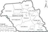
Communities

Township (United States)
A township in the United States is a small geographic area. Townships range in size from 6 to 54 square miles , with being the norm.The term is used in three ways....
are listed, each followed by its incorporated towns in bold and other unincorporated communities:
- Franklin (central)
- FranklinFranklin, North CarolinaFranklin is a town in Franklin Township, Macon County, North Carolina, United States, within the Nantahala National Forest. The population was 3,490 as of the 2000 census. It is the county seat of Macon County. Franklin is an official Appalachian Trail friendly destination...
- Iotla
- Prentiss
- Franklin
- Highlands (southeast)
- HighlandsHighlands, North CarolinaHighlands is an incorporated town in Macon County in the U.S. state of North Carolina. Located on a plateau in the southern Appalachian Mountains, within the Nantahala National Forest, it lies mostly in southeastern Macon County and slightly in southwestern Jackson County, in the Highlands and...
- Highlands
- Sugarfork (east-southeast)
- Cullasaja
- Peek's Creek
- Gneiss
- Burningtown (north-northwest)
- Cartoogechaye (west-southwest)
- Rainbow Springs
- Cowee (north-northeast)
- Oak GroveOak Grove, Macon County, North CarolinaOak Grove is an unincorporated community in Macon County, North Carolina, on North Carolina Highway 28, north-northwest of Franklin, North Carolina. It lies at an elevation of 1988 feet ....
- West's Mill
- Oak Grove
- Ellijay (east)
- NantahalaNantahala, North CarolinaThe Nantahala area is located in North Carolina in the part of Macon County which is west of Wayah Gap. It has a population of 1,711. "Nantahala" is a Cherokee word which means "Land of the Noonday Sun." The area fits its name because in a few spots, the sun’s rays only reaches the floors of the...
(northwest)- Aquone
- Kyle
- Smithbridge, originally Smith's Bridge (south-southwest)
- Otto
- Millshoal (east-northeast)
- Holly Springs
- Flats (south-central)
- Scaly MountainScaly Mountain, North CarolinaScaly Mountain is a small unincorporated community along North Carolina highway 106, southwest of Highlands, North Carolina and northeast of Dillard, Georgia , and nearest to Sky Valley, Georgia just to the south-southwest...
- Scaly Mountain
Communities where correct township is unconfirmed:
- Etna
- Leatherman
Union Academy
Union Academy is an alternative Public school in Macon County, North Carolina for grades 6–12. It is located at near the South Macon Elementary school. Its name was changed from Union Alternative in 2006 following the retirement of former principal Larry Brooks, who later became the principal of the Cowee Elementary school. The current principal is Kris Reis, who has changed the school policies drastically. As it was never meant to house either middle school or high school students it is the smallest of these schools in the general area.Macon Early College
Macon Early College is a high school that offers college classes located next to thegreenway
Greenway (landscape)
A greenway is a long, narrow piece of land, often used for recreation and pedestrian and bicycle user traffic, and sometimes for streetcar, light rail or retail uses.- Terminology :...
and public library
Public library
A public library is a library that is accessible by the public and is generally funded from public sources and operated by civil servants. There are five fundamental characteristics shared by public libraries...
of Franklin. Southwestern Community College (North Carolina) is a partner in the program. As of 2008, SCC was ranked 4th in the list of Americas best community
colleges. Macon Early College is one of the three high schools in the Macon area, coming into existence after the Franklin High School
Franklin High School (North Carolina)
Franklin High School is the largest high school in Macon County, North Carolina. As the name suggests, Franklin High is located in the town of Franklin, next to small shops and residential areas. There has been a rapid increase in the student body in the last few years....
but before the Union Academy.