
Washington & Old Dominion Railroad Regional Park
Encyclopedia
The Washington & Old Dominion Railroad Regional Park is a popular and unusually-shaped regional park
in Northern Virginia
. The park's primary feature is the Washington & Old Dominion Railroad Trail (abbreviated as W&OD Trail), an asphalt-surfaced paved rail trail
that runs through densely populated urban
and suburban communities as well as through rural
areas. Most of the trail travels on top of the rail bed of the former Washington and Old Dominion Railroad
, which closed in 1968.
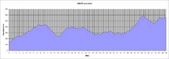
Although the park is 44.8 miles (72.1 km) long, it is only about 100 feet (30.5 m) wide. The rail trail is approximately 10 feet (3 m) wide through much of its length and is suitable for walking
, running
, cycling
, and roller skating
. A crushed bluestone surfaced bridle path
travels near the paved trail in the park's most westerly 32 miles (51.5 km).
The Northern Virginia Regional Park Authority
(NVRPA) administers and maintains the park and its trails. NVRPA keeps most of the parkland surrounding the trails in a natural state. The park authority has placed alongside the paved trail a series of mile markers
and a number of interpretative exhibits that describe the historic and natural features of the park (see Washington and Old Dominion Railroad#Stations for locations of historical markers near the W&OD Trail).
The headquarters office of the park is near the east side of the trail at Smith's Switch Road near Ashburn
. A park rest stop is adjacent to the trail near the park's headquarters.
 The W&OD Trail begins near the Nauck neighborhood in the Shirlington
section of Arlington County
, close to the boundary between the County and the City of Alexandria
. The trail ends in Purcellville
in western Loudoun County
. Its route largely parallels the routes of the Potomac River
and Virginia State Route 7 (VA Route 7)
.
The trail connects at its origin to the paved Four Mile Run Trail
, which travels eastward through Arlington along a stream embankment to meet the Mount Vernon Trail
at Ronald Reagan Washington National Airport
, near the Potomac River. The start of the trail is also accessible from the Shirlington exit (Exit 6) of Interstate 395
(I-395) (the Henry G. Shirley Memorial Highway)
.
The trail parallels the more curving and hilly Four Mile Run Trail throughout its route in Arlington. Although they coincide in several locations, the two trails generally travel on opposite sides of the Run. There are no restrooms and few water fountains alongside the W&OD Trail in the County. Restrooms and additional water fountains are available near ball fields and picnic areas along the Four Mile Run Trail.
The W&OD trailhead (Mile 0) is at the intersection
of South Shirlington Road and South Four Mile Run Drive. The trail starts in the Atlantic Coastal Plain
at the trail's lowest elevation
141 feet (43 m) above sea level
.
The trail climbs 195 feet (59.4 m) in 5.9 miles (9.5 km) while traveling northwest through Arlington County. While in Arlington, the trail ascends through the Atlantic Seaboard fall line
while climbing upstream
in the valley
of Four Mile Run
. The trail crosses the Run seven times in the valley on bridge
s whose abutment
s were constructed before the Civil War
by the Alexandria, Loudoun & Hampshire Railroad, a predecessor of the W&OD Railroad.
After crossing Columbia Pike (VA Route 244
), the trail enters a steeply-sloped woodland that covers both sides of the valley. Near the end of the woodland, the trail intersects the Bluemont Junction Trail, a paved rail trail that travels to Ballston on the bed of a former W&OD Railroad branch that once ran to Rosslyn
and Georgetown
. 0.6 mile (0.965604 km) past that intersection, the W&OD Trail meets the Custis Trail
, which travels along I-66
(the Custis Memorial Parkway) between East Falls Church and Rosslyn and which provides access to Washington, D.C.
After joining at their intersection, the W&OD and Custis Trails share the same path as they travel northwest near an I-66 soundwall
for most of their remaining courses in Arlington.
After leaving the fall line, the W&OD Trail enters the Piedmont plateau region
near the west corner of the County. The trail continues to climb in the Piedmont while traveling northwest through Falls Church
and Fairfax County
. The trail reaches an elevation of 450 feet (137.2 m) at its crossing of I-66 in Fairfax County. When it reaches this point, the trail has risen 309 feet (94.2 m) while traveling 8.4 miles (13.5 km).
After crossing I-495
(the Capital Beltway) and passing Dunn Loring
, the trail begins a long descent as it travels through Vienna
. After leaving Vienna, the trail continues to descend until it reaches Difficult Run
(Mile 14.3), where its elevation of 240 feet (73.2 m) is only about 100 feet (30.5 m) higher than is the elevation at the trail's origin.
After the trail crosses Difficult Run, it ascends and descends between additional streams (including Sugarland Run, Broad Run, Beaverdam Run, Goose Creek
, Sycolin Creek and Tuscarora Creek) as it travels further northwest in the Piedmont through or near Reston
, Herndon
, Sterling
, Ashburn and Leesburg
. When crossing Tuscarora Creek in Leesburg, the trail's elevation of 273 feet (83.2 m) is 63 feet (19.2 m) lower than the highest elevation that it reached in Arlington.
After crossing Tuscarora Creek, the trail climbs 337 feet (102.7 m) northwest in 6.3 miles (10.1 km) to reach its highest elevation (610 feet (185.9 m)) when crossing a bridge carrying VA Route 9
(Charles Town Pike) over VA Route 7 near the saddle point
of Clarks Gap in Catoctin Mountain
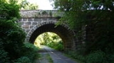
. 0.3 mile (0.482802 km) before this crossing, the trail travels under an old stone arch
that formerly carried VA Route 7 over the W&OD Railroad.
The trail then turns west, descends through Paeonian Springs
to Hamilton Station
and climbs to reach Purcellville. When the trail terminates in Purcellville, its elevation is 564 feet (171.9 m) above sea level.
in Alexandria to the center of Purcellville. Soon after the railroad closed, the Virginia Department of Highways
purchased the railroad's property from the line's owner, the Chesapeake and Ohio Railway
, with the intent of using a portion of the right-of-way for the construction of I-66. Shortly thereafter, the Virginia Electric and Power Company (part of which was incorporated into Dominion Virginia Power in 2000) purchased most of the property from the highway department, as the company's electric power transmission lines
were travelling within the right-of-way.
The first portion of the W&OD Trail opened in 1974 within the City of Falls Church under a lease agreement between the City government, the power company
and NVRPA. As the trail proved to be popular, NVRPA purchased this and additional segments of the right-of-way from the power company between 1978 and 1982. The power company retained an easement
that permitted the company to maintain its lines and to extend them along the right-of-way if needed.
NVRPA was not able to acquire from the power company the portion of the right-of-way that lay within the City of Alexandria. NVRPA also could not acquire the portion of right-of-way that the highway department had retained for construction of I-66 near East Falls Church in Arlington and various portions of the right-of-way that contained existing or potential highway crossings.
NVRPA extended the trail east and west of Falls Church as it acquired portions of the right-of-way. In 1987, the National Park Service
designated the trail as a National Recreation Trail
. The trail reached Purcellville in 1988. After encountering opposition from the public because of its potential environmental impacts, the final section of the trail opened in and near Arlington's Bluemont Park in 2002.
On October 20, 2007, construction began for a paved trail that would connect the W&OD Trail at its origin with the Four Mile Run Trail by traveling for 3000 feet (914.4 m) along a bank of the Run while passing beneath the Henry G. Shirley Memorial Highway (I-395) in Alexandria and West Glebe Road in Arlington. On May 30, 2009, a ribbon-cutting ceremony heralded the completion and opening of the connecting trail.
remnants, including intact stations
at Vienna, Sunset Hills, Herndon, Hamilton and Purcellville, stone arches and culvert
s, the piers
and abutments of bridges, and a relocated passenger shelter (formerly at Clarks Gap; now at Paeonian Springs).
Part of the reinforced concrete
floor of a brick
electrical substation
that the railroad constructed in 1912 to help supply power
to its new electric locomotive
s and trolley cars
is visible in Arlington County's Bluemont Junction Railroad Display south of Wilson Boulevard. The floor is located in the space between a soccer field and a Southern Railway caboose
.
A partially intact elevated railroad siding
remains visible south of the W&OD Trail on private property west of the trail's crossing of Lee Highway (U.S. Route 29) in Arlington. The siding was once adjacent to the west side of the railroad's Falls Church (East Falls Church) station, which was dismantled after the railroad closed.
A white metal
lic marker post lettered in black with the words "Station 1 Mile" stands on the north side of the trail west of Little Falls Road near the boundary between Arlington and Falls Church. This post, which once stood next to the W&OD Railroad's tracks, is one mile (1.6 km) east of the site of the railroad's demolished West Falls Church Station. The station was located near the east side of the railroad's crossing of W. Broad Street (VA Route 7) in Falls Church.
 Near the east end of Vienna, the poured concrete
abutment of a bridge that carried an interurban trolley line
, the Washington-Virginia Railway
, over the W&OD Railroad remains on the north side of the trail. An inscription showing the month and year of the abutment's construction (July 1904) is visible on the structure's east side.
The trail crosses Goose Creek in Loudoun County on a span that NVRPA built on top of the piers and abutments of the highest and longest (268 feet (81.7 m)) bridge that the railroad constructed within the present boundaries of the regional park. Visitors can view these remnants and the intact span, pier and abutments of the railroad's deck girder bridge over Sycolin Creek from unpaved paths that travel between the streams in NVRPA's Two Creeks Trail Area on the north side of the trail.
The Sycolin Creek bridge bears the only remaining span that once carried trains of the W&OD Railroad. As the trail travels on the concrete deck of the bridge, visitors can only see the span and the structures below if they leave the trail.
The piers and abutments of the railroad's bridge over Tuscarora Creek are visible south of the trail near the east end of Leesburg. The bridge was the second longest (149 feet (45.4 m)) that the railroad built within the present boundaries of the regional park. The piers and abutments are the only ones along the trail's route that do not presently support a bridge.
Remnants of the facilities of a 19th century lime
company are visible in Leesburg on the northeast side of the trail, southeast of Harrison Street SE. Limestone
(calcium carbonate
) from a company quarry
was mixed with coal
and burned in a nearby kiln that was adjacent to the railroad's tracks. Quicklime (calcium oxide)
was brought out of the kiln through two arched openings that visitors can see from the trail. The company supplied farmers with fertilizer (agricultural lime
) and provided builders with plaster
for walls and stone for roads.
Near the saddle point of Clarks Gap, a stone arch crosses over the trail. Constructed around 1867-1868 soon after the end of the Civil War, the masonry
arch once carried the original VA Route 7 over the railroad's tracks at the railroad's highest point. The arch now carries Dry Mill Road (VA Route 699) over the trail.
A registration form prepared to support the nomination of the park for inclusion in the National Register of Historic Places
contains an in-depth description of the park's historical resources and of the railroad's history, as well as maps that show the locations of the park's major historical features. The form states that the park is eligible for listing on the Register because its property "is associated with events that have made a significant contribution to the broad patterns of our history."
and its predecessors have donated three caboose
s for display along the W&OD Trail. While none of these resemble the cabooses that once travelled along the route of the W&OD Railroad, two of the three cars
house exhibits of materials relating to the W&OD Railroad and Trail.
A Southern Railway bay window caboose within the Bluemont Junction Railroad Display in Arlington exhibits photographs, maps and other information related to the County's railroads and trolleys. Staffed by a County park ranger, the caboose is open to the public on weekend afternoons from May through October. The display also contains outdoor signage and photographs that describe and illustrate the history of the W&OD Railroad and of its junction that once operated at the site of the exhibit, as well as a metallic crossbuck
and a metallic marker post that was once located 1 miles (1.6 km) from a station.
A cupola caboose near the Trail in Vienna Centennial Park contains a museum that houses materials that the W&OD Railroad once used. Staffed by members of the Optimist Club
of Greater Vienna, bearing on its sides the name "WASHINGTON & OLD DOMINION" and numbered 503, the caboose is open to the public during the afternoons on selected weekends and holidays. Near the caboose is a historical marker, an NVRPA information sign, a metallic crossbuck on a wooden post and a metallic marker post that was once located 1 miles (1.6 km) from a station. A metallic white railroad whistle post
with black markings is located in Vienna Centennial Park on the north side of the Trail between Church Street NE and the caboose.
The Freeman Store in Vienna houses a museum
of the town's history. The museum contains maps, books and other materials that relate to the W&OD Railroad. Operated by Historic Vienna, Inc., the museum is open to the public during the afternoons of each week from Wednesdays through Sundays.
The W&OD Railroad station in Vienna houses a museum and a model railroad
layout. Operated by the Northern Virginia Model Railroaders, Inc., the museum displays materials that the W&OD Railroad once used and a model of the station as it appeared when steam locomotive
s stopped at the station. The model railroad and museum is open to the public during the afternoon of one Saturday of each month except June and August.
An overlook at the Luck Stone Quarry east of Goose Creek displays a large trap rock
quarry. This mineral
provides bulk for concrete
and macadam
.
The W&OD Railroad station in Herndon houses the Herndon Depot Museum, which the Herndon Historical Society, Inc., operates. The museum, which is open on Sundays from noon to 3:00 p.m., displays photographs and newspaper articles relating to the history of the Town of Herndon and the W&OD Railroad. The museum also contains materials that the railroad once used. The museum additionally contains information about the history of a nearby Norfolk Southern Railway cupola caboose whose sides bore the name and logo
of the W&OD Railroad and the number 504 in 2006. A railroad whistle post is located near the caboose
and to provide wildlife
habitat
. Some natural areas within the park are contiguous
to larger natural areas in adjacent public parks, including those in and around the Sparrow Pond wetland, Brandymore Castle and Four Mile Run
in Arlington, Piney Branch and Difficult Run in Fairfax County, and the confluence
of Goose Creek and Sycolin Creek in Loudoun County.
Park interpreters, local teachers, environmental groups and amateur naturalists use the park as a resource for plant and animal study. These groups have identified approximately 450 species
of wildflower
s and more than 100 species of bird
s in the park. Wildlife in the park includes mammal
s such as fox
es, river otters
and beaver
s, and reptile
s such as turtle
s and snake
s. A variety of hawk
s and owl
s and other resident, non-resident and migratory birds
, both upland and aquatic
, find habitat in the park.
In 2004, Dominion Virginia Power announced plans to extend its transmission lines in Loudoun County above ground from the Pleasant View Substation northwestward along the route of the W&OD Trail. In response, on November 15, 2005, the Loudoun County Board of Supervisors unanimously
adopted a resolution of continued opposition to the installation of the proposed transmission lines along the Trail. The resolution stated:
Citing the impending loss of trees along its trail, the NVRPA asked the public on December 13, 2005, to oppose Dominion Virginia Power's application for the transmission line project in hearings that the State Corporation Commission (SCC) was planning to conduct as part of its review of the project. During 2005, 2006 and 2007, the NVRPA submitted testimony and briefs
to the SCC that opposed the construction of transmission lines along the route of the trail.
The SCC nevertheless approved on February 15, 2008, a transmission line route that would travel above ground for 1.8 miles (2.9 km) along a wooded
portion of the W&OD Trail between Leesburg and Clarks Gap. Less than three weeks later, on March 4 and March 5, 2008, the Senate
and the House of Delegates
of the Virginia General Assembly
unanimously passed emergency legislation that ordered the SCC to approve the underground construction of the line along that section of the trail as part of a state-wide pilot program
for the development of such types of transmission lines. Sponsored by Delegate Joe T. May (Republican
- Loudoun), the legislation exempted the project from any requirements for further SCC analyses relating to the impacts of the route, including environmental impacts and impacts upon historical resources. The legislation went into effect when Virginia Governor
Tim Kaine
approved it on April 2, 2008.
The NVRPA expected the project to result in a significant loss of trees, as the power company planned to dig trench
es on each side of the paved trail while installing duct banks to house its conduits
. Supporting the NVRPA's expectation, Dominion Virginia Power noted that the environmental impacts associated with underground cable installation in suburban and rural areas are significantly greater than are those of overhead line construction. The W&OD Trail closed for a year in the project area while the power company constructed its underground lines. The trail reopened to the public in November 2010.
} Interactive map of entire W&OD Trail and trail segments showing mileages and features along trail
} Map and chart of elevations along W&OD Trail
Regional park
Regional park is a term used for an area of land preserved on account of its natural beauty, historic interest, recreational use or other reason, and under the administration of a form of local government.-Definition:...
in Northern Virginia
Northern Virginia
Northern Virginia consists of several counties and independent cities in the Commonwealth of Virginia, in a widespread region generally radiating southerly and westward from Washington, D.C...
. The park's primary feature is the Washington & Old Dominion Railroad Trail (abbreviated as W&OD Trail), an asphalt-surfaced paved rail trail
Rail trail
A rail trail is the conversion of a disused railway easement into a multi-use path, typically for walking, cycling and sometimes horse riding. The characteristics of former tracks—flat, long, frequently running through historical areas—are appealing for various development. The term sometimes also...
that runs through densely populated urban
Urban area
An urban area is characterized by higher population density and vast human features in comparison to areas surrounding it. Urban areas may be cities, towns or conurbations, but the term is not commonly extended to rural settlements such as villages and hamlets.Urban areas are created and further...
and suburban communities as well as through rural
Rural
Rural areas or the country or countryside are areas that are not urbanized, though when large areas are described, country towns and smaller cities will be included. They have a low population density, and typically much of the land is devoted to agriculture...
areas. Most of the trail travels on top of the rail bed of the former Washington and Old Dominion Railroad
Washington and Old Dominion Railroad
The Washington and Old Dominion Railroad was an intrastate short-line railroad located in Northern Virginia. Its oldest line extended from Alexandria on the Potomac River northwest to Bluemont at the foot of the Blue Ridge Mountains near Snickers Gap, not far from the boundary line between...
, which closed in 1968.
Although the park is 44.8 miles (72.1 km) long, it is only about 100 feet (30.5 m) wide. The rail trail is approximately 10 feet (3 m) wide through much of its length and is suitable for walking
Walking
Walking is one of the main gaits of locomotion among legged animals, and is typically slower than running and other gaits. Walking is defined by an 'inverted pendulum' gait in which the body vaults over the stiff limb or limbs with each step...
, running
Running
Running is a means of terrestrial locomotion allowing humans and other animals to move rapidly on foot. It is simply defined in athletics terms as a gait in which at regular points during the running cycle both feet are off the ground...
, cycling
Cycling
Cycling, also called bicycling or biking, is the use of bicycles for transport, recreation, or for sport. Persons engaged in cycling are cyclists or bicyclists...
, and roller skating
Roller skating
Roller skating is the traveling on smooth surfaces with roller skates. It is a form of recreation as well as a sport, and can also be a form of transportation. Skates generally come in two basic varieties: quad roller skates and inline skates or blades, though some have experimented with a...
. A crushed bluestone surfaced bridle path
Bridle path
A bridle path is a thoroughfare originally made for horses, but which these days serves a wide range of interests, including hikers, walkers and cyclists as well as equestrians. The laws relating to permissions vary from country to country...
travels near the paved trail in the park's most westerly 32 miles (51.5 km).
The Northern Virginia Regional Park Authority
Northern Virginia Regional Park Authority
The Northern Virginia Regional Park Authority is an interjurisdictional organization that owns and operates more than 10,000 acres of woodlands, streams, parks, trails, nature reserves, countryside and historic sites in Northern Virginia in the United States. The Authority was organized in 1959...
(NVRPA) administers and maintains the park and its trails. NVRPA keeps most of the parkland surrounding the trails in a natural state. The park authority has placed alongside the paved trail a series of mile markers
Milestone
A milestone is one of a series of numbered markers placed along a road or boundary at intervals of one mile or occasionally, parts of a mile. They are typically located at the side of the road or in a median. They are alternatively known as mile markers, mileposts or mile posts...
and a number of interpretative exhibits that describe the historic and natural features of the park (see Washington and Old Dominion Railroad#Stations for locations of historical markers near the W&OD Trail).
The headquarters office of the park is near the east side of the trail at Smith's Switch Road near Ashburn
Ashburn, Virginia
Ashburn, Virginia is a census-designated place located in Loudoun County, Virginia, northwest of Washington, D.C., and is part of the Washington Metropolitan Area...
. A park rest stop is adjacent to the trail near the park's headquarters.
Trail route
Shirlington, Virginia
Shirlington is an unincorporated urban area, officially called an "urban village", in the southern part of Arlington County, Virginia, United States, adjacent to the Fairlington area...
section of Arlington County
Arlington County, Virginia
Arlington County is a county in the Commonwealth of Virginia. The land that became Arlington was originally donated by Virginia to the United States government to form part of the new federal capital district. On February 27, 1801, the United States Congress organized the area as a subdivision of...
, close to the boundary between the County and the City of Alexandria
Alexandria, Virginia
Alexandria is an independent city in the Commonwealth of Virginia. As of 2009, the city had a total population of 139,966. Located along the Western bank of the Potomac River, Alexandria is approximately six miles south of downtown Washington, D.C.Like the rest of northern Virginia, as well as...
. The trail ends in Purcellville
Purcellville, Virginia
Purcellville is a town in the Loudoun Valley of Loudoun County, Virginia, United States. The population was 3,584 at the 2000 census, but has undergone considerable growth since then. Purcellville is the major population center for western Loudoun and the Loudoun Valley...
in western Loudoun County
Loudoun County, Virginia
Loudoun County is a county located in the Commonwealth of Virginia, and is part of the Washington Metropolitan Area. As of the 2010 U.S. Census, the county is estimated to be home to 312,311 people, an 84 percent increase over the 2000 figure of 169,599. That increase makes the county the fourth...
. Its route largely parallels the routes of the Potomac River
Potomac River
The Potomac River flows into the Chesapeake Bay, located along the mid-Atlantic coast of the United States. The river is approximately long, with a drainage area of about 14,700 square miles...
and Virginia State Route 7 (VA Route 7)
Virginia State Route 7
State Route 7 is a major primary state highway and busy commuter route in Northern Virginia, United States. It travels southeast from downtown Winchester to State Route 400 in downtown Alexandria...
.
The trail connects at its origin to the paved Four Mile Run Trail
Four Mile Run Trail
The Four Mile Run Trail is a 7-mile, paved bike trail in Arlington County, Virginia that runs along Four Mile Run from Falls Church to the Mount Vernon Trail near Ronald Reagan Washington National Airport, where Four Mile Run empties into the Potomac River...
, which travels eastward through Arlington along a stream embankment to meet the Mount Vernon Trail
Mount Vernon Trail
The Mount Vernon Trail is a popular running and bike path in Northern Virginia that follows the west bank of the Potomac River from near Theodore Roosevelt Island to Mount Vernon. The northern, urban half is open and has views of Washington, D.C. across the river. The southern below Alexandria is...
at Ronald Reagan Washington National Airport
Ronald Reagan Washington National Airport
Ronald Reagan Washington National Airport is a public airport located south of downtown Washington, D.C., in Arlington County, Virginia. It is the commercial airport nearest to Washington, D.C. For many decades, it was called Washington National Airport, but this airport was renamed in 1998 to...
, near the Potomac River. The start of the trail is also accessible from the Shirlington exit (Exit 6) of Interstate 395
Interstate 395 (District of Columbia-Virginia)
Interstate 395 in Washington, D.C., and Virginia is a 13 mile long spur route that begins at a junction with Interstate 95 in Springfield, Virginia and ends in northwest Washington, D.C. It passes underneath the National Mall near the United States Capitol and ends at a junction with U.S...
(I-395) (the Henry G. Shirley Memorial Highway)
Henry G. Shirley Memorial Highway
The Henry G. Shirley Memorial Highway consists of a portion of Interstates 95 and 395 in the U.S. state of Virginia. Shirley Highway was the first limited-access freeway in Virginia...
.
The trail parallels the more curving and hilly Four Mile Run Trail throughout its route in Arlington. Although they coincide in several locations, the two trails generally travel on opposite sides of the Run. There are no restrooms and few water fountains alongside the W&OD Trail in the County. Restrooms and additional water fountains are available near ball fields and picnic areas along the Four Mile Run Trail.
The W&OD trailhead (Mile 0) is at the intersection
Intersection (road)
An intersection is a road junction where two or more roads either meet or cross at grade . An intersection may be 3-way - a T junction or fork, 4-way - a crossroads, or 5-way or more...
of South Shirlington Road and South Four Mile Run Drive. The trail starts in the Atlantic Coastal Plain
Atlantic Coastal Plain
The Atlantic coastal plain has both low elevation and low relief, but it is also a relatively flat landform extending from the New York Bight southward to a Georgia/Florida section of the Eastern Continental Divide, which demarcates the plain from the ACF River Basin in the Gulf Coastal Plain to...
at the trail's lowest elevation
Elevation
The elevation of a geographic location is its height above a fixed reference point, most commonly a reference geoid, a mathematical model of the Earth's sea level as an equipotential gravitational surface ....
141 feet (43 m) above sea level
Sea level
Mean sea level is a measure of the average height of the ocean's surface ; used as a standard in reckoning land elevation...
.
The trail climbs 195 feet (59.4 m) in 5.9 miles (9.5 km) while traveling northwest through Arlington County. While in Arlington, the trail ascends through the Atlantic Seaboard fall line
Atlantic Seaboard fall line
The Atlantic Seaboard Fall Line, or Fall Zone, is a escarpment where the Piedmont and Atlantic coastal plain meet in the eastern United States...
while climbing upstream
Upstream
In geography, upstream literally means towards the source of a stream or river, or against the normal direction of water flow.Upstream is the opposite of downstream...
in the valley
Valley
In geology, a valley or dale is a depression with predominant extent in one direction. A very deep river valley may be called a canyon or gorge.The terms U-shaped and V-shaped are descriptive terms of geography to characterize the form of valleys...
of Four Mile Run
Four Mile Run
Four Mile Run is a stream in northern Virginia that starts near Interstate 66, at Gordon Avenue in Fairfax County and proceeds southeast through Falls Church to Arlington County in the U.S. state of Virginia...
. The trail crosses the Run seven times in the valley on bridge
Bridge
A bridge is a structure built to span physical obstacles such as a body of water, valley, or road, for the purpose of providing passage over the obstacle...
s whose abutment
Abutment
An abutment is, generally, the point where two structures or objects meet. This word comes from the verb abut, which means adjoin or having common boundary. An abutment is an engineering term that describes a structure located at the ends of a bridge, where the bridge slab adjoins the approaching...
s were constructed before the Civil War
American Civil War
The American Civil War was a civil war fought in the United States of America. In response to the election of Abraham Lincoln as President of the United States, 11 southern slave states declared their secession from the United States and formed the Confederate States of America ; the other 25...
by the Alexandria, Loudoun & Hampshire Railroad, a predecessor of the W&OD Railroad.
After crossing Columbia Pike (VA Route 244
Virginia State Route 244
State Route 244, also known as Columbia Pike, is a primary state highway in the U.S. state of Virginia. It is a four-lane road that runs from State Route 236 in Annandale, Fairfax County east to State Route 27 at the Pentagon in Arlington County.-History:Columbia Pike dates to 1810 when the U.S...
), the trail enters a steeply-sloped woodland that covers both sides of the valley. Near the end of the woodland, the trail intersects the Bluemont Junction Trail, a paved rail trail that travels to Ballston on the bed of a former W&OD Railroad branch that once ran to Rosslyn
Rosslyn, Virginia
Rosslyn is an unincorporated area in Northern Virginia located in the northeastern corner of Arlington County, Virginia, north of Arlington National Cemetery and directly across the Potomac River from Georgetown in Washington, D.C. Rosslyn encompasses the Arlington neighborhoods of North Rosslyn...
and Georgetown
Georgetown, Washington, D.C.
Georgetown is a neighborhood located in northwest Washington, D.C., situated along the Potomac River. Founded in 1751, the port of Georgetown predated the establishment of the federal district and the City of Washington by 40 years...
. 0.6 mile (0.965604 km) past that intersection, the W&OD Trail meets the Custis Trail
Custis Trail
The Custis Trail is a 4-mile, paved bike trail in Arlington County, Virginia that extends from Key Bridge at Rosslyn westward to the Washington & Old Dominion Railroad Trail...
, which travels along I-66
Interstate 66
Interstate 66 is an Interstate Highway in the eastern United States. As indicated by its even route number, it runs in an east–west direction. Its western terminus is at Middletown, Virginia, at an intersection with Interstate 81; its eastern terminus is in Washington, D.C., at an...
(the Custis Memorial Parkway) between East Falls Church and Rosslyn and which provides access to Washington, D.C.
Washington, D.C.
Washington, D.C., formally the District of Columbia and commonly referred to as Washington, "the District", or simply D.C., is the capital of the United States. On July 16, 1790, the United States Congress approved the creation of a permanent national capital as permitted by the U.S. Constitution....
After joining at their intersection, the W&OD and Custis Trails share the same path as they travel northwest near an I-66 soundwall
Noise barrier
A noise barrier is an exterior structure designed to protect sensitive land uses from noise pollution...
for most of their remaining courses in Arlington.
After leaving the fall line, the W&OD Trail enters the Piedmont plateau region
Piedmont (United States)
The Piedmont is a plateau region located in the eastern United States between the Atlantic Coastal Plain and the main Appalachian Mountains, stretching from New Jersey in the north to central Alabama in the south. The Piedmont province is a physiographic province of the larger Appalachian division...
near the west corner of the County. The trail continues to climb in the Piedmont while traveling northwest through Falls Church
Falls Church, Virginia
The City of Falls Church is an independent city in Virginia, United States, in the Washington Metropolitan Area. The city population was 12,332 in 2010, up from 10,377 in 2000. Taking its name from The Falls Church, an 18th-century Anglican parish, Falls Church gained township status within...
and Fairfax County
Fairfax County, Virginia
Fairfax County is a county in Virginia, in the United States. Per the 2010 Census, the population of the county is 1,081,726, making it the most populous jurisdiction in the Commonwealth of Virginia, with 13.5% of Virginia's population...
. The trail reaches an elevation of 450 feet (137.2 m) at its crossing of I-66 in Fairfax County. When it reaches this point, the trail has risen 309 feet (94.2 m) while traveling 8.4 miles (13.5 km).
After crossing I-495
Interstate 495 (Capital Beltway)
Interstate 495 is a Interstate Highway that surrounds the United States' capital of Washington, D.C., and its inner suburbs in adjacent Maryland and Virginia. I-495 is widely known as the Capital Beltway or simply the Beltway, especially when the context of Washington, D.C., is clear...
(the Capital Beltway) and passing Dunn Loring
Dunn Loring, Virginia
Dunn Loring is a census-designated place in Fairfax County, Virginia, United States. The population was 8,803 at the 2010 census.-History:...
, the trail begins a long descent as it travels through Vienna
Vienna, Virginia
Vienna is a town in Fairfax County, Virginia, United States. As of the 2010 United States Census, it had a population of 15,687. Significantly more people live in zip codes with the Vienna postal addresses bordered approximately by Interstate 66 on the south, Interstate 495 on the east, Route 7 to...
. After leaving Vienna, the trail continues to descend until it reaches Difficult Run
Difficult Run
Difficult Run is a tributary stream of the Potomac River in northern Virginia in the United States. The term "run" for "stream" is common usage in this part of Virginia and throughout the mid-Atlantic region; another "run" is better known in American Civil War history: Bull Run. Difficult Run...
(Mile 14.3), where its elevation of 240 feet (73.2 m) is only about 100 feet (30.5 m) higher than is the elevation at the trail's origin.
After the trail crosses Difficult Run, it ascends and descends between additional streams (including Sugarland Run, Broad Run, Beaverdam Run, Goose Creek
Goose Creek (Potomac River)
Goose Creek is a tributary of the Potomac River in Fauquier and Loudoun counties in northern Virginia. It comprises the principal drainage system for the Loudoun Valley.-Course:...
, Sycolin Creek and Tuscarora Creek) as it travels further northwest in the Piedmont through or near Reston
Reston, Virginia
Reston is a census-designated place in Fairfax County, Virginia, United States, within the Washington, D.C. metropolitan area. The population was 58,404, at the 2010 Census and 56,407 at the 2000 census...
, Herndon
Herndon, Virginia
Herndon is a town in Fairfax County, Virginia, in the Washington, D.C. metropolitan area of the United States. The population was 21,655 at the 2000 census, which makes it the largest of three towns in the county.-History:...
, Sterling
Sterling, Virginia
Sterling, Virginia is a census-designated place in Loudoun County, Virginia. The population as of the 2010 Census was 27,822.It is located northwest of Herndon, east of Ashburn, and west of Great Falls, and includes part of Dulles International Airport and the former AOL corporate headquarters...
, Ashburn and Leesburg
Leesburg, Virginia
Leesburg is a historic town in, and county seat of, Loudoun County, Virginia, United States of America. Leesburg is located west-northwest of Washington, D.C. along the base of the Catoctin Mountain and adjacent to the Potomac River. Its population according the 2010 Census is 42,616...
. When crossing Tuscarora Creek in Leesburg, the trail's elevation of 273 feet (83.2 m) is 63 feet (19.2 m) lower than the highest elevation that it reached in Arlington.
After crossing Tuscarora Creek, the trail climbs 337 feet (102.7 m) northwest in 6.3 miles (10.1 km) to reach its highest elevation (610 feet (185.9 m)) when crossing a bridge carrying VA Route 9
Virginia State Route 9
Virginia State Route 9 is a primary state highway in the U.S. state of Virginia. Known as Charles Town Pike, the state highway runs from the West Virginia state line near Mechanicsville, where the highway continues west as West Virginia Route 9 , east to SR 7 and SR 7 Business near Paeonian...
(Charles Town Pike) over VA Route 7 near the saddle point
Saddle point
In mathematics, a saddle point is a point in the domain of a function that is a stationary point but not a local extremum. The name derives from the fact that in two dimensions the surface resembles a saddle that curves up in one direction, and curves down in a different direction...
of Clarks Gap in Catoctin Mountain
Catoctin Mountain
Catoctin Mountain, along with the geologically associated Bull Run Mountains, comprises the easternmost mountain ridge of the Blue Ridge Mountains, which are in turn a part of the Appalachian Mountains range...
. 0.3 mile (0.482802 km) before this crossing, the trail travels under an old stone arch
Arch
An arch is a structure that spans a space and supports a load. Arches appeared as early as the 2nd millennium BC in Mesopotamian brick architecture and their systematic use started with the Ancient Romans who were the first to apply the technique to a wide range of structures.-Technical aspects:The...
that formerly carried VA Route 7 over the W&OD Railroad.
The trail then turns west, descends through Paeonian Springs
Paeonian Springs, Virginia
Paeonian Springs is an unincorporated community in Loudoun County, Virginia, USA. It is located on the Charles Town Pike near its intersection with the Harry Byrd Highway . Paeonian Springs was established in 1890 and is currently served by a post office.- External links :*...
to Hamilton Station
Hamilton, Virginia
Hamilton is a town in the Loudoun Valley of Loudoun County, Virginia, United States. The population was 562 as of the 2000 census.-Geography:...
and climbs to reach Purcellville. When the trail terminates in Purcellville, its elevation is 564 feet (171.9 m) above sea level.
W&OD Trail features
| Feature | Jurisdiction | Distance from Trailhead |
Trail Elevation |
Coordinates |
|---|---|---|---|---|
| Four Mile Run Trail Four Mile Run Trail The Four Mile Run Trail is a 7-mile, paved bike trail in Arlington County, Virginia that runs along Four Mile Run from Falls Church to the Mount Vernon Trail near Ronald Reagan Washington National Airport, where Four Mile Run empties into the Potomac River... -W&OD Trail Connector |
City of Alexandria Arlington County |
---- | ---- | 38.8431442°N 77.0811725°W |
| Trailhead | Arlington County | 0 | 141 feet (43 m) | 38.844245°N 77.08584°W |
| Crossing of Columbia Pike (VA Route 244) | Arlington County | 1.6 miles (2.6 km) | 209 feet (63.7 m) | 38.856398°N 77.109649°W |
| Overlook Overlook A scenic overlook, or just an overlook, observation point, lookout or viewing point, is a high place where people can gather to view scenery , and to photograph it. Scenic overlooks are typically created alongside mountain roads, often as a simple turnouts where motorists can pull over onto... of Sparrow Pond wetland Wetland A wetland is an area of land whose soil is saturated with water either permanently or seasonally. Wetlands are categorised by their characteristic vegetation, which is adapted to these unique soil conditions.... |
Arlington County | 2.1 miles (3.4 km) | 237 feet (72.2 m) | 38.862077°N 77.115532°W |
| Arlington Boulevard Arlington Boulevard Arlington Boulevard is a major arterial road in Arlington County, Fairfax County, and the independent City of Fairfax in Northern Virginia in metropolitan Washington, DC, United States. It is designated U.S... (U.S. Route 50 U.S. Route 50 in Virginia U.S. Route 50 is a transcontinental highway which stretches from Ocean City, Maryland to Sacramento, California. In the U.S. state of Virginia, US 50 extends from the border with Washington DC at a Potomac River crossing at Rosslyn in Arlington County to the West Virginia state line near Gore in... ) bridge over trail and Four Mile Run |
Arlington County | 2.6 miles (4.2 km) | 249 feet (75.9 m) | 38.866501°N 77.123769°W |
| Carlin Springs Road bridge over trail and Four Mile Run | Arlington County | 3 miles (4.8 km) | 232 feet (70.7 m) | 38.867893°N 77.127749°W |
| Intersection with Bluemont Junction Trail | Arlington County | 3.3 miles (5.3 km) | 243 feet (74.1 m) | 38.871832°N 77.132108°W |
| Bluemont Junction Railroad Display and Caboose | Arlington County | 3.4 miles (5.5 km) | 243 feet (74.1 m) | 38.87306°N 77.132564°W |
| Wilson Boulevard bridge over trail and Four Mile Run | Arlington County | 3.5 miles (5.6 km) | 243 feet (74.1 m) | 38.875012°N 77.133618°W |
| Intersection with Custis Trail | Arlington County | 3.9 miles (6.3 km) | 272 feet (82.9 m) | 38.879128°N 77.13877°W |
| Brandymore Castle (rock outcrop Outcrop An outcrop is a visible exposure of bedrock or ancient superficial deposits on the surface of the Earth. -Features:Outcrops do not cover the majority of the Earth's land surface because in most places the bedrock or superficial deposits are covered by a mantle of soil and vegetation and cannot be... ) |
Arlington County | 4.8 miles (7.7 km) | 299 feet (91.1 m) | 38.883792°N 77.153437°W |
| East Falls Church Metro Station East Falls Church (Washington Metro) East Falls Church is a Washington Metro station in Arlington, Virginia on the Orange Line.-Location:The station serves the suburban communities of Falls Church and Arlington, Virginia and is located in the median of Interstate 66 near Lee Highway . Service began on June 7, 1986... |
Arlington County | 5.3 miles (8.5 km) | 336 feet (102.4 m) | 38.886072°N 77.157047°W |
| Crossing of Lee Highway Lee Highway The Lee Highway was a National Auto Trail in the United States connecting New York City and San Francisco, California via the South and Southwest. It was named after Robert E... (U.S. Route 29 U.S. Route 29 in Virginia U.S. Route 29 is a major north–south route in the Commonwealth of Virginia. It covers from the North Carolina border at the city of Danville to the Key Bridge in Washington, D.C.... ) |
Arlington County | 5.5 miles (8.9 km) | 336 feet (102.4 m) | 38.8874°N 77.16217°W |
| Former site of Falls Church W&OD Railroad station | Arlington County | 5.6 miles (9 km) | 336 feet (102.4 m) | 38.887358°N 77.162631°W |
| Elevated W&OD Railroad siding | Arlington County | 5.6 miles (9 km) | 336 feet (102.4 m) | 38.88745°N 77.163076°W |
| Crossing of Little Falls Road | Arlington County | 5.9 miles (9.5 km) | 325 feet (99.1 m) | 38.888313°N 77.165928°W |
| W&OD Railroad station mile marker post | City of Falls Church | 5.9 miles (9.5 km) | 325 feet (99.1 m) | 38.888471°N 77.166426°W |
| Former site of West Falls Church W&OD Railroad station | City of Falls Church | 6.9 miles (11.1 km) | 388 feet (118.3 m) | 38.891649°N 77.185226°W |
| Trail bridge over West Broad Street (VA Route 7) | City of Falls Church | 7 miles (11.3 km) | 388 feet (118.3 m) | 38.891768°N 77.185972°W |
| Trail and Virginia Lane bridge over I-66 and Washington Metro Washington Metro The Washington Metro, commonly called Metro, and unofficially Metrorail, is the rapid transit system in Washington, D.C., United States, and its surrounding suburbs. It is administered by the Washington Metropolitan Area Transit Authority , which also operates Metrobus service under the Metro name... |
Fairfax County | 8.4 miles (13.5 km) | 453 feet (138.1 m) | 38.890995°N 77.2106°W |
| Trail bridge over I-495 (Capital Beltway) | Fairfax County | 8.9 miles (14.3 km) | 417 feet (127.1 m) | 38.890478°N 77.217863°W |
| Sandburg Street, Dunn Loring | Fairfax County | 9.1 miles (14.6 km) | 417 feet (127.1 m) | 38.8916257°N 77.2223264°W |
| Washington-Virginia Railway bridge abutments | Town of Vienna | 10.4 miles (16.7 km) | 447 feet (136.2 m) | 38.89988°N 77.245718°W |
| Freeman Store General store A general store, general merchandise store, or village shop is a rural or small town store that carries a general line of merchandise. It carries a broad selection of merchandise, sometimes in a small space, where people from the town and surrounding rural areas come to purchase all their general... and Museum |
Town of Vienna | 11.6 miles (18.7 km) | 376 feet (114.6 m) | 38.903357°N 77.265113°W |
| Railroad whistle post Whistle post A whistle post , in railroad usage, is a sign marking a location where a locomotive engineer is required to sound the horn or whistle.-United States:... in Vienna Centennial Park |
Town of Vienna | 11.7 miles (18.8 km) | 376 feet (114.6 m) | 38.9033584°N 77.2655408°W |
| Vienna Caboose and Museum in Vienna Centennial Park | Town of Vienna | 11.7 miles (18.8 km) | 376 feet (114.6 m) | 38.903608°N 77.265708°W |
| Vienna W&OD Railroad Station and model railroad | Town of Vienna | 11.8 miles (19 km) | 349 feet (106.4 m) | 38.904142°N 77.266974°W |
| Trail bridge over Piney Branch | Fairfax County | 13.6 miles (21.9 km) | 260 feet (79.2 m) | 38.925642°N 77.288381°W |
| Trail bridge over Difficult Run | Fairfax County | 14.3 miles (23 km) | 240 feet (73.2 m) | 38.930942°N 77.29834°W |
| Dulles Access Road and Dulles Toll Road (VA Route 267) Virginia State Route 267 State Route 267 is a primary state highway in the U.S. state of Virginia. It consists of two end-to-end toll roads – the Dulles Toll Road and Dulles Greenway – as well as the Dulles Access Road,... bridges over trail |
Fairfax County | 16.1 miles (25.9 km) | 354 feet (107.9 m) | 38.944607°N 77.325618°W |
| Sunset Hills W&OD Railroad Station, Reston | Fairfax County | 17.7 miles (28.5 km) | 379 feet (115.5 m) | 38.955869°N 77.351789°W |
| Intersection with trail to Reston Town Center Reston Town Center The Reston Town Center is a group of offices, stores, and restaurants in Reston, Virginia.-Layout:The Reston Town Center is designed with open avenues and with wide sidewalks. It is built around Fountain Square, a medium-sized open area between the surrounding shops. The main landmark in Fountain... |
Fairfax County | 18.2 miles (29.3 km) | 408 feet (124.4 m) | 38.956347°N 77.361318°W |
| Intersection with trail to Fairfax County Parkway Trail | Fairfax County | 18.6 miles (29.9 km) | 386 feet (117.7 m) | 38.957696°N 77.368381°W |
| Sugarland Run culvert | Town of Herndon | 18.8 miles (30.3 km) | 376 feet (114.6 m) | 38.9596028°N 77.3711514°W |
| Herndon Depot Museum Herndon Depot Museum The Herndon Depot Museum, also known as the Herndon Historical Society Museum, is located in the town of Herndon in Fairfax County, Virginia. Built in 1857 for the Alexandria, Loudoun & Hampshire Railroad, the depot later served the Richmond and Danville Railroad, the Southern Railway and the... |
Town of Herndon | 19.9 miles (32 km) | 373 feet (113.7 m) | 38.970174°N 77.385716°W |
| Herndon Caboose | Town of Herndon | 20 miles (32.2 km) | 373 feet (113.7 m) | 38.970733°N 77.386073°W |
| West Church Road bridge over trail, Sterling | Loudoun County | 23.3 miles (37.5 km) | 317 feet (96.6 m) | 39.0053911°N 77.4278775°W |
| Trail bridge over Sully Road (VA Route 28 Virginia State Route 28 State Route 28 is a primary state highway that traverses the counties of Loudoun, Fairfax, Prince William, and Fauquier in the U.S. state of Virginia. It is a major artery through Northern Virginia.-Loudoun County:... ) (viewpoint) |
Loudoun County | 23.9 miles (38.5 km) | 299 feet (91.1 m) | 39.011481°N 77.433336°W |
| Trail bridge over Broad Run | Loudoun County | 24.6 miles (39.6 km) | 269 feet (82 m) | 39.01845°N 77.444923°W |
| W&OD Regional Park Headquarters, Ashburn | Loudoun County | 25.8 miles (41.5 km) | 261 feet (79.6 m) | 39.02736°N 77.46082°W |
| Smiths Switch Station rest stop, Ashburn | Loudoun County | 25.8 miles (41.5 km) | 261 feet (79.6 m) | 39.027615°N 77.460367°W |
| Trail bridge over Beaverdam Run | Loudoun County | 26.2 miles (42.2 km) | 261 feet (79.6 m) | 39.031905°N 77.467293°W |
| Crossing of Ashburn Road (VA Route 641) | Loudoun County | 27.5 miles (44.3 km) | 320 feet (97.5 m) | 39.0439736°N 77.487430°W |
| Overlook of Luck Stone Quarry | Loudoun County | 29.6 miles (47.6 km) | 309 feet (94.2 m) | 39.0673679°N 77.5174338°W |
| Trail bridge over Goose Creek | Loudoun County | 30.1 miles (48.4 km) | 286 feet (87.2 m) | 39.0695212°N 77.5195795°W |
| Entrance to Two Creeks Trail Area | Loudoun County | 30.2 miles (48.6 km) | 286 feet (87.2 m) | 39.0705874°N 77.5206256°W |
| Trail bridge over Sycolin Creek | Loudoun County | 30.4 miles (48.9 km) | 271 feet (82.6 m) | 39.0723324°N 77.524707°W |
| Pleasant View Substation Electrical substation A substation is a part of an electrical generation, transmission, and distribution system. Substations transform voltage from high to low, or the reverse, or perform any of several other important functions... of Dominion Virginia Power |
Loudoun County | 30.8 miles (49.6 km) | 306 feet (93.3 m) | 39.07718°N 77.529472°W |
| Trail bridge over Tuscarora Creek | Town of Leesburg | 32.2 miles (51.8 km) | 273 feet (83.2 m) | 39.0955799°N 77.5422549°W |
| VA Route 7/U.S. Route 15 bridges over trail |
Town of Leesburg | 33 miles (53.1 km) | 286 feet (87.2 m) | 39.100376°N 77.549829°W |
| 19th century lime kiln | Town of Leesburg | 34.1 miles (54.9 km) | 326 feet (99.4 m) | 39.109596°N 77.561014°W |
| Crossing of Harrison Street SE | Town of Leesburg | 34.3 miles (55.2 km) | 330 feet (100.6 m) | 39.1104°N 77.563198°W |
| Crossing of S. King Street (U.S. Route 15 (Business)) | Town of Leesburg | 34.4 miles (55.4 km) | 330 feet (100.6 m) | 39.111986°N 77.566137°W |
| Trail bridge over VA Route 7 | Town of Leesburg | 35.5 miles (57.1 km) | 405 feet (123.4 m) | 39.11035°N 77.587756°W |
| Stone arch over trail at Clarks Gap | Loudoun County | 38.2 miles (61.5 km) | 574 feet (175 m) | 39.13957°N 77.610887°W |
| Trail and VA Route 9 (Charles Town Pike) bridge over VA Route 7 at Clarks Gap |
Loudoun County | 38.5 miles (62 km) | 610 feet (185.9 m) | 39.1409245°N 77.6123893°W |
| Clarks Gap passenger shelter (relocated), Paeonian Springs |
Loudoun County | 39.2 miles (63.1 km) | 562 feet (171.3 m) | 39.147768°N 77.619438°W |
| Hamilton W&OD Railroad Station | Loudoun County | 40.9 miles (65.8 km) | 472 feet (143.9 m) | 39.144091°N 77.651303°W |
| VA Route 7 bridges over trail and Berlin Turnpike (VA Route 287 Virginia State Route 287 Virginia State Route 287 is a primary state highway in the U.S. state of Virginia. Known as Berlin Pike, the state highway runs from SR 7 Business in Purcellville north to the Maryland state line at the Potomac River near Lovettsville, where the highway continues as Maryland Route 17... ) |
Loudoun County | 43.2 miles (69.5 km) | 554 feet (168.9 m) | 39.1445587°N 77.6916969°W |
| Purcellville W&OD Railroad Station | Town of Purcellville | 44.8 miles (72.1 km) | 564 feet (171.9 m) | 39.138441°N 77.716116°W |
| End of trail | Town of Purcellville | 44.8 miles (72.1 km) | 564 feet (171.9 m) | 39.138515°N 77.716277°W |
History of the regional park
When the W&OD Railroad closed in 1968, its 100 feet (30.5 m) wide right-of-way extended from Potomac YardPotomac Yard
Potomac Yard was one of the busiest rail yards on the Eastern Seaboard of the United States. Today, it refers to the neighborhood encompassing the same, which straddles southeastern Arlington County and northern Alexandria, Virginia, bounded by U.S. Route 1, the George Washington Memorial Parkway,...
in Alexandria to the center of Purcellville. Soon after the railroad closed, the Virginia Department of Highways
Virginia Department of Transportation
The Virginia Department of Transportation is the agency of state government responsible for transportation in the state of Virginia in the United States. Headquartered in Downtown Richmond, VDOT is responsible for building, maintaining, and operating the roads, bridges and tunnels in the...
purchased the railroad's property from the line's owner, the Chesapeake and Ohio Railway
Chesapeake and Ohio Railway
The Chesapeake and Ohio Railway was a Class I railroad formed in 1869 in Virginia from several smaller Virginia railroads begun in the 19th century. Led by industrialist Collis P...
, with the intent of using a portion of the right-of-way for the construction of I-66. Shortly thereafter, the Virginia Electric and Power Company (part of which was incorporated into Dominion Virginia Power in 2000) purchased most of the property from the highway department, as the company's electric power transmission lines
Electric power transmission
Electric-power transmission is the bulk transfer of electrical energy, from generating power plants to Electrical substations located near demand centers...
were travelling within the right-of-way.
The first portion of the W&OD Trail opened in 1974 within the City of Falls Church under a lease agreement between the City government, the power company
Electrical power industry
The electric power industry provides the production and delivery of electric energy, often known as power, or electricity, in sufficient quantities to areas that need electricity through a grid connection. The grid distributes electrical energy to customers...
and NVRPA. As the trail proved to be popular, NVRPA purchased this and additional segments of the right-of-way from the power company between 1978 and 1982. The power company retained an easement
Easement
An easement is a certain right to use the real property of another without possessing it.Easements are helpful for providing pathways across two or more pieces of property or allowing an individual to fish in a privately owned pond...
that permitted the company to maintain its lines and to extend them along the right-of-way if needed.
NVRPA was not able to acquire from the power company the portion of the right-of-way that lay within the City of Alexandria. NVRPA also could not acquire the portion of right-of-way that the highway department had retained for construction of I-66 near East Falls Church in Arlington and various portions of the right-of-way that contained existing or potential highway crossings.
NVRPA extended the trail east and west of Falls Church as it acquired portions of the right-of-way. In 1987, the National Park Service
National Park Service
The National Park Service is the U.S. federal agency that manages all national parks, many national monuments, and other conservation and historical properties with various title designations...
designated the trail as a National Recreation Trail
National Recreation Trail
National Recreation Trail is a designation given to existing trails that contribute to health, conservation, and recreation goals in the United States. Over 1,000 trails in all 50 U.S. states, available for public use and ranging from less than a mile to in length, have been designated as NRTs...
. The trail reached Purcellville in 1988. After encountering opposition from the public because of its potential environmental impacts, the final section of the trail opened in and near Arlington's Bluemont Park in 2002.
On October 20, 2007, construction began for a paved trail that would connect the W&OD Trail at its origin with the Four Mile Run Trail by traveling for 3000 feet (914.4 m) along a bank of the Run while passing beneath the Henry G. Shirley Memorial Highway (I-395) in Alexandria and West Glebe Road in Arlington. On May 30, 2009, a ribbon-cutting ceremony heralded the completion and opening of the connecting trail.
Historic structures in the regional park
The park and its immediate surroundings contain a number of historic structures, some of which date to the pre-Civil War period. Most of these structures are railroadRail transport
Rail transport is a means of conveyance of passengers and goods by way of wheeled vehicles running on rail tracks. In contrast to road transport, where vehicles merely run on a prepared surface, rail vehicles are also directionally guided by the tracks they run on...
remnants, including intact stations
Train station
A train station, also called a railroad station or railway station and often shortened to just station,"Station" is commonly understood to mean "train station" unless otherwise qualified. This is evident from dictionary entries e.g...
at Vienna, Sunset Hills, Herndon, Hamilton and Purcellville, stone arches and culvert
Culvert
A culvert is a device used to channel water. It may be used to allow water to pass underneath a road, railway, or embankment. Culverts can be made of many different materials; steel, polyvinyl chloride and concrete are the most common...
s, the piers
Pier (architecture)
In architecture, a pier is an upright support for a superstructure, such as an arch or bridge. Sections of wall between openings function as piers. The simplest cross section of the pier is square, or rectangular, although other shapes are also common, such as the richly articulated piers of Donato...
and abutments of bridges, and a relocated passenger shelter (formerly at Clarks Gap; now at Paeonian Springs).
Part of the reinforced concrete
Reinforced concrete
Reinforced concrete is concrete in which reinforcement bars , reinforcement grids, plates or fibers have been incorporated to strengthen the concrete in tension. It was invented by French gardener Joseph Monier in 1849 and patented in 1867. The term Ferro Concrete refers only to concrete that is...
floor of a brick
Brick
A brick is a block of ceramic material used in masonry construction, usually laid using various kinds of mortar. It has been regarded as one of the longest lasting and strongest building materials used throughout history.-History:...
electrical substation
Electrical substation
A substation is a part of an electrical generation, transmission, and distribution system. Substations transform voltage from high to low, or the reverse, or perform any of several other important functions...
that the railroad constructed in 1912 to help supply power
Electric power
Electric power is the rate at which electric energy is transferred by an electric circuit. The SI unit of power is the watt.-Circuits:Electric power, like mechanical power, is represented by the letter P in electrical equations...
to its new electric locomotive
Electric locomotive
An electric locomotive is a locomotive powered by electricity from overhead lines, a third rail or an on-board energy storage device...
s and trolley cars
History of electric trams
-History:The world's first electric tram line opened in Lichterfelde near Berlin, Germany, in 1881. It was built by Werner von Siemens . In Britain, Volk's electric railway was opened in 1883 in Brighton . Also in 1883, Mödling and Hinterbrühl Tram was opened near Vienna in Austria...
is visible in Arlington County's Bluemont Junction Railroad Display south of Wilson Boulevard. The floor is located in the space between a soccer field and a Southern Railway caboose
Caboose
A caboose is a manned North American rail transport vehicle coupled at the end of a freight train. Although cabooses were once used on nearly every freight train, their use has declined and they are seldom seen on trains, except on locals and smaller railroads.-Function:The caboose provided the...
.
A partially intact elevated railroad siding
Rail siding
A siding, in rail terminology, is a low-speed track section distinct from a running line or through route such as a main line or branch line or spur. It may connect to through track or to other sidings at either end...
remains visible south of the W&OD Trail on private property west of the trail's crossing of Lee Highway (U.S. Route 29) in Arlington. The siding was once adjacent to the west side of the railroad's Falls Church (East Falls Church) station, which was dismantled after the railroad closed.
A white metal
Metal
A metal , is an element, compound, or alloy that is a good conductor of both electricity and heat. Metals are usually malleable and shiny, that is they reflect most of incident light...
lic marker post lettered in black with the words "Station 1 Mile" stands on the north side of the trail west of Little Falls Road near the boundary between Arlington and Falls Church. This post, which once stood next to the W&OD Railroad's tracks, is one mile (1.6 km) east of the site of the railroad's demolished West Falls Church Station. The station was located near the east side of the railroad's crossing of W. Broad Street (VA Route 7) in Falls Church.
Concrete
Concrete is a composite construction material, composed of cement and other cementitious materials such as fly ash and slag cement, aggregate , water and chemical admixtures.The word concrete comes from the Latin word...
abutment of a bridge that carried an interurban trolley line
Interurban
An interurban, also called a radial railway in parts of Canada, is a type of electric passenger railroad; in short a hybrid between tram and train. Interurbans enjoyed widespread popularity in the first three decades of the twentieth century in North America. Until the early 1920s, most roads were...
, the Washington-Virginia Railway
Northern Virginia trolleys
The earliest electric railway, or streetcar line, in Northern Virginia opened in 1892. At their peak, when merged into a single interurban system , the successors of this and several other lines ran between downtown Washington, D.C., Rosslyn and Arlington Junction – present day Crystal City...
, over the W&OD Railroad remains on the north side of the trail. An inscription showing the month and year of the abutment's construction (July 1904) is visible on the structure's east side.
The trail crosses Goose Creek in Loudoun County on a span that NVRPA built on top of the piers and abutments of the highest and longest (268 feet (81.7 m)) bridge that the railroad constructed within the present boundaries of the regional park. Visitors can view these remnants and the intact span, pier and abutments of the railroad's deck girder bridge over Sycolin Creek from unpaved paths that travel between the streams in NVRPA's Two Creeks Trail Area on the north side of the trail.
The Sycolin Creek bridge bears the only remaining span that once carried trains of the W&OD Railroad. As the trail travels on the concrete deck of the bridge, visitors can only see the span and the structures below if they leave the trail.
The piers and abutments of the railroad's bridge over Tuscarora Creek are visible south of the trail near the east end of Leesburg. The bridge was the second longest (149 feet (45.4 m)) that the railroad built within the present boundaries of the regional park. The piers and abutments are the only ones along the trail's route that do not presently support a bridge.
Remnants of the facilities of a 19th century lime
Lime (mineral)
Lime is a general term for calcium-containing inorganic materials, in which carbonates, oxides and hydroxides predominate. Strictly speaking, lime is calcium oxide or calcium hydroxide. It is also the name for a single mineral of the CaO composition, occurring very rarely...
company are visible in Leesburg on the northeast side of the trail, southeast of Harrison Street SE. Limestone
Limestone
Limestone is a sedimentary rock composed largely of the minerals calcite and aragonite, which are different crystal forms of calcium carbonate . Many limestones are composed from skeletal fragments of marine organisms such as coral or foraminifera....
(calcium carbonate
Calcium carbonate
Calcium carbonate is a chemical compound with the formula CaCO3. It is a common substance found in rocks in all parts of the world, and is the main component of shells of marine organisms, snails, coal balls, pearls, and eggshells. Calcium carbonate is the active ingredient in agricultural lime,...
) from a company quarry
Quarry
A quarry is a type of open-pit mine from which rock or minerals are extracted. Quarries are generally used for extracting building materials, such as dimension stone, construction aggregate, riprap, sand, and gravel. They are often collocated with concrete and asphalt plants due to the requirement...
was mixed with coal
Coal
Coal is a combustible black or brownish-black sedimentary rock usually occurring in rock strata in layers or veins called coal beds or coal seams. The harder forms, such as anthracite coal, can be regarded as metamorphic rock because of later exposure to elevated temperature and pressure...
and burned in a nearby kiln that was adjacent to the railroad's tracks. Quicklime (calcium oxide)
Calcium oxide
Calcium oxide , commonly known as quicklime or burnt lime, is a widely used chemical compound. It is a white, caustic, alkaline crystalline solid at room temperature....
was brought out of the kiln through two arched openings that visitors can see from the trail. The company supplied farmers with fertilizer (agricultural lime
Agricultural lime
Agricultural lime, also called aglime, agricultural limestone, garden lime or liming, is a soil additive made from pulverized limestone or chalk. The primary active component is calcium carbonate...
) and provided builders with plaster
Plaster
Plaster is a building material used for coating walls and ceilings. Plaster starts as a dry powder similar to mortar or cement and like those materials it is mixed with water to form a paste which liberates heat and then hardens. Unlike mortar and cement, plaster remains quite soft after setting,...
for walls and stone for roads.
Near the saddle point of Clarks Gap, a stone arch crosses over the trail. Constructed around 1867-1868 soon after the end of the Civil War, the masonry
Masonry
Masonry is the building of structures from individual units laid in and bound together by mortar; the term masonry can also refer to the units themselves. The common materials of masonry construction are brick, stone, marble, granite, travertine, limestone; concrete block, glass block, stucco, and...
arch once carried the original VA Route 7 over the railroad's tracks at the railroad's highest point. The arch now carries Dry Mill Road (VA Route 699) over the trail.
A registration form prepared to support the nomination of the park for inclusion in the National Register of Historic Places
National Register of Historic Places
The National Register of Historic Places is the United States government's official list of districts, sites, buildings, structures, and objects deemed worthy of preservation...
contains an in-depth description of the park's historical resources and of the railroad's history, as well as maps that show the locations of the park's major historical features. The form states that the park is eligible for listing on the Register because its property "is associated with events that have made a significant contribution to the broad patterns of our history."
Displays and museums along the W&OD Trail
The Norfolk Southern RailwayNorfolk Southern Railway
The Norfolk Southern Railway is a Class I railroad in the United States, owned by the Norfolk Southern Corporation. With headquarters in Norfolk, Virginia, the company operates 21,500 route miles in 22 eastern states, the District of Columbia and the province of Ontario, Canada...
and its predecessors have donated three caboose
Caboose
A caboose is a manned North American rail transport vehicle coupled at the end of a freight train. Although cabooses were once used on nearly every freight train, their use has declined and they are seldom seen on trains, except on locals and smaller railroads.-Function:The caboose provided the...
s for display along the W&OD Trail. While none of these resemble the cabooses that once travelled along the route of the W&OD Railroad, two of the three cars
Railroad car
A railroad car or railway vehicle , also known as a bogie in Indian English, is a vehicle on a rail transport system that is used for the carrying of cargo or passengers. Cars can be coupled together into a train and hauled by one or more locomotives...
house exhibits of materials relating to the W&OD Railroad and Trail.
A Southern Railway bay window caboose within the Bluemont Junction Railroad Display in Arlington exhibits photographs, maps and other information related to the County's railroads and trolleys. Staffed by a County park ranger, the caboose is open to the public on weekend afternoons from May through October. The display also contains outdoor signage and photographs that describe and illustrate the history of the W&OD Railroad and of its junction that once operated at the site of the exhibit, as well as a metallic crossbuck
Crossbuck
A crossbuck is a sign composed of two slats of wood or metal of equal length, fastened together on a pole in a saltire formation...
and a metallic marker post that was once located 1 miles (1.6 km) from a station.
A cupola caboose near the Trail in Vienna Centennial Park contains a museum that houses materials that the W&OD Railroad once used. Staffed by members of the Optimist Club
Optimist International
Optimist International is an international service club organization with 3,200 clubs and almost 100,000 members in more than 35 nations throughout the world. The international headquarters is located in St...
of Greater Vienna, bearing on its sides the name "WASHINGTON & OLD DOMINION" and numbered 503, the caboose is open to the public during the afternoons on selected weekends and holidays. Near the caboose is a historical marker, an NVRPA information sign, a metallic crossbuck on a wooden post and a metallic marker post that was once located 1 miles (1.6 km) from a station. A metallic white railroad whistle post
Whistle post
A whistle post , in railroad usage, is a sign marking a location where a locomotive engineer is required to sound the horn or whistle.-United States:...
with black markings is located in Vienna Centennial Park on the north side of the Trail between Church Street NE and the caboose.
The Freeman Store in Vienna houses a museum
Museum
A museum is an institution that cares for a collection of artifacts and other objects of scientific, artistic, cultural, or historical importance and makes them available for public viewing through exhibits that may be permanent or temporary. Most large museums are located in major cities...
of the town's history. The museum contains maps, books and other materials that relate to the W&OD Railroad. Operated by Historic Vienna, Inc., the museum is open to the public during the afternoons of each week from Wednesdays through Sundays.
The W&OD Railroad station in Vienna houses a museum and a model railroad
Rail transport modelling
Railway modelling or model railroading is a hobby in which rail transport systems are modelled at a reduced scale...
layout. Operated by the Northern Virginia Model Railroaders, Inc., the museum displays materials that the W&OD Railroad once used and a model of the station as it appeared when steam locomotive
Steam locomotive
A steam locomotive is a railway locomotive that produces its power through a steam engine. These locomotives are fueled by burning some combustible material, usually coal, wood or oil, to produce steam in a boiler, which drives the steam engine...
s stopped at the station. The model railroad and museum is open to the public during the afternoon of one Saturday of each month except June and August.
An overlook at the Luck Stone Quarry east of Goose Creek displays a large trap rock
Trap rock
Trap rock is a form of igneous rock that tends to form polygonal vertical fractures, most typically hexagonal, but also four to eight sided. The fracture pattern forms when magma of suitable chemical composition intrudes as a sill or extrudes as a thick lava flow, and slowly cools.Because of the...
quarry. This mineral
Mineral
A mineral is a naturally occurring solid chemical substance formed through biogeochemical processes, having characteristic chemical composition, highly ordered atomic structure, and specific physical properties. By comparison, a rock is an aggregate of minerals and/or mineraloids and does not...
provides bulk for concrete
Concrete
Concrete is a composite construction material, composed of cement and other cementitious materials such as fly ash and slag cement, aggregate , water and chemical admixtures.The word concrete comes from the Latin word...
and macadam
Macadam
Macadam is a type of road construction pioneered by the Scotsman John Loudon McAdam in around 1820. The method simplified what had been considered state-of-the-art at that point...
.
The W&OD Railroad station in Herndon houses the Herndon Depot Museum, which the Herndon Historical Society, Inc., operates. The museum, which is open on Sundays from noon to 3:00 p.m., displays photographs and newspaper articles relating to the history of the Town of Herndon and the W&OD Railroad. The museum also contains materials that the railroad once used. The museum additionally contains information about the history of a nearby Norfolk Southern Railway cupola caboose whose sides bore the name and logo
Logo
A logo is a graphic mark or emblem commonly used by commercial enterprises, organizations and even individuals to aid and promote instant public recognition...
of the W&OD Railroad and the number 504 in 2006. A railroad whistle post is located near the caboose
Natural resources of the regional park
Most of the landscaping in the park is left in a natural state to preserve green spaceNatural environment
The natural environment encompasses all living and non-living things occurring naturally on Earth or some region thereof. It is an environment that encompasses the interaction of all living species....
and to provide wildlife
Wildlife
Wildlife includes all non-domesticated plants, animals and other organisms. Domesticating wild plant and animal species for human benefit has occurred many times all over the planet, and has a major impact on the environment, both positive and negative....
habitat
Habitat
* Habitat , a place where a species lives and grows*Human habitat, a place where humans live, work or play** Space habitat, a space station intended as a permanent settlement...
. Some natural areas within the park are contiguous
Contiguity
A contiguity is a continuous mass, or a series of things in contact or proximity. In a different meaning, contiguity is the state of being contiguous...
to larger natural areas in adjacent public parks, including those in and around the Sparrow Pond wetland, Brandymore Castle and Four Mile Run
Four Mile Run
Four Mile Run is a stream in northern Virginia that starts near Interstate 66, at Gordon Avenue in Fairfax County and proceeds southeast through Falls Church to Arlington County in the U.S. state of Virginia...
in Arlington, Piney Branch and Difficult Run in Fairfax County, and the confluence
Confluence
Confluence, in geography, describes the meeting of two or more bodies of water.Confluence may also refer to:* Confluence , a property of term rewriting systems...
of Goose Creek and Sycolin Creek in Loudoun County.
Park interpreters, local teachers, environmental groups and amateur naturalists use the park as a resource for plant and animal study. These groups have identified approximately 450 species
Species
In biology, a species is one of the basic units of biological classification and a taxonomic rank. A species is often defined as a group of organisms capable of interbreeding and producing fertile offspring. While in many cases this definition is adequate, more precise or differing measures are...
of wildflower
Wildflower
A wildflower is a flower that grows wild, meaning it was not intentionally seeded or planted. Yet "wildflower" meadows of a few mixed species are sold in seed packets. The term "wildflower" has been made vague by commercial seedsmen who are interested in selling more flowers or seeds more...
s and more than 100 species of bird
Bird
Birds are feathered, winged, bipedal, endothermic , egg-laying, vertebrate animals. Around 10,000 living species and 188 families makes them the most speciose class of tetrapod vertebrates. They inhabit ecosystems across the globe, from the Arctic to the Antarctic. Extant birds range in size from...
s in the park. Wildlife in the park includes mammal
Mammal
Mammals are members of a class of air-breathing vertebrate animals characterised by the possession of endothermy, hair, three middle ear bones, and mammary glands functional in mothers with young...
s such as fox
Fox
Fox is a common name for many species of omnivorous mammals belonging to the Canidae family. Foxes are small to medium-sized canids , characterized by possessing a long narrow snout, and a bushy tail .Members of about 37 species are referred to as foxes, of which only 12 species actually belong to...
es, river otters
Otter
The Otters are twelve species of semi-aquatic mammals which feed on fish and shellfish, and also other invertebrates, amphibians, birds and small mammals....
and beaver
Beaver
The beaver is a primarily nocturnal, large, semi-aquatic rodent. Castor includes two extant species, North American Beaver and Eurasian Beaver . Beavers are known for building dams, canals, and lodges . They are the second-largest rodent in the world...
s, and reptile
Reptile
Reptiles are members of a class of air-breathing, ectothermic vertebrates which are characterized by laying shelled eggs , and having skin covered in scales and/or scutes. They are tetrapods, either having four limbs or being descended from four-limbed ancestors...
s such as turtle
Turtle
Turtles are reptiles of the order Testudines , characterised by a special bony or cartilaginous shell developed from their ribs that acts as a shield...
s and snake
Snake
Snakes are elongate, legless, carnivorous reptiles of the suborder Serpentes that can be distinguished from legless lizards by their lack of eyelids and external ears. Like all squamates, snakes are ectothermic, amniote vertebrates covered in overlapping scales...
s. A variety of hawk
Hawk
The term hawk can be used in several ways:* In strict usage in Australia and Africa, to mean any of the species in the subfamily Accipitrinae, which comprises the genera Accipiter, Micronisus, Melierax, Urotriorchis and Megatriorchis. The large and widespread Accipiter genus includes goshawks,...
s and owl
Owl
Owls are a group of birds that belong to the order Strigiformes, constituting 200 bird of prey species. Most are solitary and nocturnal, with some exceptions . Owls hunt mostly small mammals, insects, and other birds, although a few species specialize in hunting fish...
s and other resident, non-resident and migratory birds
Bird migration
Bird migration is the regular seasonal journey undertaken by many species of birds. Bird movements include those made in response to changes in food availability, habitat or weather. Sometimes, journeys are not termed "true migration" because they are irregular or in only one direction...
, both upland and aquatic
Aquatic ecosystem
An aquatic ecosystem is an ecosystem in a body of water. Communities of organisms that are dependent on each other and on their environment live in aquatic ecosystems. The two main types of aquatic ecosystems are marine ecosystems and freshwater ecosystems....
, find habitat in the park.
Transmission lines in the regional park
The W&OD Trail lies beneath a set of electric power transmission lines between its trailhead and the Dominion Virginia Power's Pleasant View Substation in Loudoun County southeast of Leesburg. The power company removes trees along this section of the trail to protect its lines, at times eliciting protests from members of the public and elected officials in the impacted jurisdictions. Trees shade much of the remainder of the trail.In 2004, Dominion Virginia Power announced plans to extend its transmission lines in Loudoun County above ground from the Pleasant View Substation northwestward along the route of the W&OD Trail. In response, on November 15, 2005, the Loudoun County Board of Supervisors unanimously
Unanimity
Unanimity is agreement by all people in a given situation. When unanimous, everybody is of the same mind and acting together as one. Though unlike uniformity, it does not constitute absolute agreement. Many groups consider unanimous decisions a sign of agreement, solidarity, and unity...
adopted a resolution of continued opposition to the installation of the proposed transmission lines along the Trail. The resolution stated:
Whereas, Virginia Electric and Power Company d/b/a Dominion Virginia Power (“Dominion” or “Virginia Power”) has caused to be filed an application (the “Application:”) with the State Corporation Commission (the “Commission”) for the installation of a 230kV transmission facility within Loudoun County between the existing Pleasant View Subdivision and a proposed substation to be located east of the Town of Purcellville (the “Hamilton Station”); .....
Whereas, Loudoun County and its citizens will be best served and least damaged if the proposed transmission facility is placed underground and is not placed on the W&OD Regional Park (the “W&OD Trail”) in any configuration; now, therefore,
Be It Resolved that the Board of Supervisors of the County of Loudoun, Virginia, on behalf of the citizens of Loudoun County, will continue to oppose any installation of the proposed facility along the W&OD Trail; and will continue to support the underground installation of the proposed facility if it is to be located within the County or any independent political subdivision of the Commonwealth located within the County; and
Be It Further Resolved that the Board of Supervisors will continue to work with the Town of Leesburg, other incorporated towns, state legislators, other stake holders, the Commission, The Virginia Department of Transportation and Virginia Power to achieve the purpose and intent of this Resolution, including the use of all legal means to ensure that any transmission facility is constructed in accordance with this Resolution.
Citing the impending loss of trees along its trail, the NVRPA asked the public on December 13, 2005, to oppose Dominion Virginia Power's application for the transmission line project in hearings that the State Corporation Commission (SCC) was planning to conduct as part of its review of the project. During 2005, 2006 and 2007, the NVRPA submitted testimony and briefs
Brief (law)
A brief is a written legal document used in various legal adversarial systems that is presented to a court arguing why the party to the case should prevail....
to the SCC that opposed the construction of transmission lines along the route of the trail.
The SCC nevertheless approved on February 15, 2008, a transmission line route that would travel above ground for 1.8 miles (2.9 km) along a wooded
Woodland
Ecologically, a woodland is a low-density forest forming open habitats with plenty of sunlight and limited shade. Woodlands may support an understory of shrubs and herbaceous plants including grasses. Woodland may form a transition to shrubland under drier conditions or during early stages of...
portion of the W&OD Trail between Leesburg and Clarks Gap. Less than three weeks later, on March 4 and March 5, 2008, the Senate
Senate of Virginia
The Senate of Virginia is the upper house of the Virginia General Assembly. The Senate is composed of 40 Senators representing an equal number of single-member constituent districts. The Senate is presided over by the Lieutenant Governor of Virginia...
and the House of Delegates
Virginia House of Delegates
The Virginia House of Delegates is the lower house of the Virginia General Assembly. It has 100 members elected for terms of two years; unlike most states, these elections take place during odd-numbered years. The House is presided over by the Speaker of the House, who is elected from among the...
of the Virginia General Assembly
Virginia General Assembly
The Virginia General Assembly is the legislative body of the Commonwealth of Virginia, and the oldest legislative body in the Western Hemisphere, established on July 30, 1619. The General Assembly is a bicameral body consisting of a lower house, the Virginia House of Delegates, with 100 members,...
unanimously passed emergency legislation that ordered the SCC to approve the underground construction of the line along that section of the trail as part of a state-wide pilot program
Pilot (experiment)
A pilot experiment, also called a pilot study, is a small scale preliminary study conducted in order to evaluate feasibility, time, cost, adverse events, and effect size in an attempt to predict an appropriate sample size and improve upon the study design prior to performance of a full-scale...
for the development of such types of transmission lines. Sponsored by Delegate Joe T. May (Republican
Republican Party (United States)
The Republican Party is one of the two major contemporary political parties in the United States, along with the Democratic Party. Founded by anti-slavery expansion activists in 1854, it is often called the GOP . The party's platform generally reflects American conservatism in the U.S...
- Loudoun), the legislation exempted the project from any requirements for further SCC analyses relating to the impacts of the route, including environmental impacts and impacts upon historical resources. The legislation went into effect when Virginia Governor
Governor of Virginia
The governor of Virginia serves as the chief executive of the Commonwealth of Virginia for a four-year term. The position is currently held by Republican Bob McDonnell, who was inaugurated on January 16, 2010, as the 71st governor of Virginia....
Tim Kaine
Tim Kaine
Timothy Michael "Tim" Kaine is a Virginia politician. Kaine served as the 70th Governor of Virginia from 2006 to 2010, and was the chairman of the Democratic National Committee from 2009 to 2011...
approved it on April 2, 2008.
The NVRPA expected the project to result in a significant loss of trees, as the power company planned to dig trench
Trench
A trench is a type of excavation or depression in the ground. Trenches are generally defined by being deeper than they are wide , and by being narrow compared to their length ....
es on each side of the paved trail while installing duct banks to house its conduits
Electrical conduit
An electrical conduit is an electrical piping system used for protection and routing of electrical wiring. Electrical conduit may be made of metal, plastic, fiber, or fired clay. Flexible conduit is available for special purposes....
. Supporting the NVRPA's expectation, Dominion Virginia Power noted that the environmental impacts associated with underground cable installation in suburban and rural areas are significantly greater than are those of overhead line construction. The W&OD Trail closed for a year in the project area while the power company constructed its underground lines. The trail reopened to the public in November 2010.
External links
- Official website:
- The Friends of the Washington & Old Dominion Trail official website
- Washington & Old Dominion Trail on Running Around Town: Washington, D.C., website Chart showing mileages along W&OD Trail
- Video of entire W&OD Trail labeled with distances, cross streets, and other items Description of W&OD Trail and surrounding areas, published in Spokes, September 2006.
- Paul McCray (former Manager, W&OD Regional Park) discussing history of W&OD Trail in Uenuma, F, "Two Decades Along the W&OD Trail", Washington Post video in Washington Post official site. Accessed June 20, 2008.
- "Washington and Old Dominion Railroad Markers" series in HMdb.org: The Historical Marker Database official website Photographs and descriptions of NVRPA markers and other markers along and near the W&OD Trail.
- Washington and Old Dominion Trail in National Recreation Trails Database in American Trails official website
- Maps:
- Map of the Washington and Old Dominion Railroad Trail Map in NVRPA marker at trailhead of W&OD Trail in Shirlington. Photographed by Roger Dean Meyer, Alexandria, Virginia, September 8, 2007. In "Washington and Old Dominion Trail" in "Washington and Old Dominion Railroad Markers" series on HMdb.org: The Historical Marker Database official website. Accessed April 2, 2008.
} Interactive map of entire W&OD Trail and trail segments showing mileages and features along trail
} Map and chart of elevations along W&OD Trail
-
- Washington & Old Dominion Trail (W&OD) on Running Around Town: Washington, D.C., website Topographic map showing entire W&OD Trail
- Washington & Old Dominion Trail on BikeWashington.org website Maps and descriptions of entire W&OD Trail and trail segments, showing connecting trails