
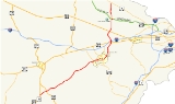
Virginia State Route 28
Encyclopedia
State Route 28 is a primary state highway
that traverses the counties of Loudoun
, Fairfax
, Prince William
, and Fauquier
in the U.S. state
of Virginia
. It is a major artery through Northern Virginia
.
 Route 28 begins as a six lane freeway at VA 7
in Sterling
in a complete interchange. It is known as Sully Road through this stretch, although within Loudoun County it is co-designated as Darrell Green Boulevard, after former Washington Redskins
player Darrell Green
. Heading south, Route 28 passes the Dulles Town Center
shopping mall and through the industrial and commercial areas of Dulles
.
The next interchange is a partial cloverleaf serving Nokes Boulevard and the Dulles Town Center
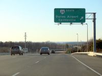
, followed by an elaborate interchange with Route 625, Waxpool Road and Church Road, which lead into Ashburn and Sterling, respectively. This interchange features two exits for Waxpool Road from the northbound lanes of Route 28: a left flyover and right loop ramp. Continuing south through Loudoun County, Route 28 has interchanges with Sterling Boulevard and Old Ox Road, the latter servicing nearby Herndon
. The final interchange in Loudoun County is the Dulles Toll/Access Road and Dulles Greenway, State Route 267, near Dulles International Airport.
, McLearen Road, the Steven F. Udvar-Hazy Center
(an annex of the National Air and Space Museum
), and US 50 in Chantilly. Route 28 travels past Chantilly to Centreville through a single-point urban interchange
with Willard Road and a cloverleaf interchange
with Westfields Boulevard.
After the interchange with Westfields Boulevard, Route 28 transitions from a freeway to an expressway
with both interchanges and at-grade intersections. Upon reaching Centreville, Route 28 intersects Interstate 66
and US 29 at partial cloverleafs, though the interchange with I-66 has traffic signals on mainline Route 28. After US 29, Route 28 changes designation from Sully Road to Centreville Road and becomes a suburban arterial with only at-grade intersections, narrowing to four lanes after an intersection with Machen Road.
into Prince William County, transitioning from a divided
to an undivided highway. The road briefly enters the City of Manassas Park before continuing into the City of Manassas
. Route 28 is a main thoroughfare through Manassas and separates into Church and Center Streets. Route 28 rejoins in front of a Confederate
cemetery
.
VDOT
has plans to create an interchange between Wellington Road and Route 28, mostly to grade-separate the crossing of Route 28 with nearby railroad tracks. This $18.3 million project was certified under the American Recovery and Reinvestment Act of 2009
on October 5, 2009, and the contract was awarded on July 14, 2010.
After leaving Manassas, Route 28 becomes Nokesville Road. The final interchange on Route 28 is SR 234
(Prince William Parkway) south of Manassas.
The road narrows from four lanes to two lanes before entering Nokesville
.
 Route 28 enters Fauquier County and changes names to Catlett Road. Route 28 is two lanes throughout rural Fauquier County with a speed limit of 45 mph (70 km/h) and passes by farms and agricultural areas. Not far from the Prince William county border Route 28 passes the Waat Bodang Temple.
Historically, the Catlett Fire Department Parade would close Route 28 for several hours each spring, however, this practice was discontinued as traffic became heavier in the 1990s. Most of the way through Fauquier County Route 28 runs parallel to railroad tracks in order to serve the towns that are placed along them. Several historal markers can be seen along Route 28 as it passes through Fauquier including Supreme Court Justice John Marshall
's birth place and the raid on Catlett Station. For many years the old bridge for Route 28 could be seen just outside of Catlett.
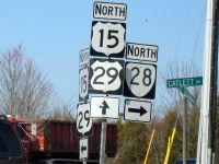
Route 28 intersects US 17 about three miles (5 km) from its terminus and ends at busy US 29/US 15 just north of Culpeper County
.
In September 2002, VDOT, the Clark Construction Group, Inc. and Shirley Contracting Company, LLC signed the Route 28 Corridor Improvements Comprehensive Agreement that provided a combined commitment of approximately $200 million in improvements over the following four years. Under this phase, six at-grade, signalized intersections were replaced with high-capacity grade-separated interchanges. Ultimate plans call for construction of a total of ten interchanges and widening Route 28 to eight lanes. The final four interchanges were completed by Spring 2010. The these interchanges were also financed by the tax surcharge.
The completion schedule for each funded interchange and roadway is as follows:
Clark is currently studying the widening of Route 28 to eight lanes and will file a proposal in the fall of 2010 expected to cover at least 30% of the 6-lane stretch. For a decade there have also been proposals to extend Route 28 to north to connect it with Interstate 370
in Gaithersburg, Maryland
over a Techway
Bridge across the Potomac River
.
State highway
State highway, state road or state route can refer to one of three related concepts, two of them related to a state or provincial government in a country that is divided into states or provinces :#A...
that traverses the counties of Loudoun
Loudoun County, Virginia
Loudoun County is a county located in the Commonwealth of Virginia, and is part of the Washington Metropolitan Area. As of the 2010 U.S. Census, the county is estimated to be home to 312,311 people, an 84 percent increase over the 2000 figure of 169,599. That increase makes the county the fourth...
, Fairfax
Fairfax County, Virginia
Fairfax County is a county in Virginia, in the United States. Per the 2010 Census, the population of the county is 1,081,726, making it the most populous jurisdiction in the Commonwealth of Virginia, with 13.5% of Virginia's population...
, Prince William
Prince William County, Virginia
-National protected areas:* Featherstone National Wildlife Refuge* Manassas National Battlefield Park* Occoquan Bay National Wildlife Refuge* Prince William Forest Park-Government and politics:...
, and Fauquier
Fauquier County, Virginia
As of the census of 2000, there were 55,139 people, 19,842 households, and 15,139 families residing in the county. The population density was 85 people per square mile . There were 21,046 housing units at an average density of 32 per square mile...
in the U.S. state
U.S. state
A U.S. state is any one of the 50 federated states of the United States of America that share sovereignty with the federal government. Because of this shared sovereignty, an American is a citizen both of the federal entity and of his or her state of domicile. Four states use the official title of...
of Virginia
Virginia
The Commonwealth of Virginia , is a U.S. state on the Atlantic Coast of the Southern United States. Virginia is nicknamed the "Old Dominion" and sometimes the "Mother of Presidents" after the eight U.S. presidents born there...
. It is a major artery through Northern Virginia
Northern Virginia
Northern Virginia consists of several counties and independent cities in the Commonwealth of Virginia, in a widespread region generally radiating southerly and westward from Washington, D.C...
.
Loudoun County
Virginia State Route 7
State Route 7 is a major primary state highway and busy commuter route in Northern Virginia, United States. It travels southeast from downtown Winchester to State Route 400 in downtown Alexandria...
in Sterling
Sterling, Virginia
Sterling, Virginia is a census-designated place in Loudoun County, Virginia. The population as of the 2010 Census was 27,822.It is located northwest of Herndon, east of Ashburn, and west of Great Falls, and includes part of Dulles International Airport and the former AOL corporate headquarters...
in a complete interchange. It is known as Sully Road through this stretch, although within Loudoun County it is co-designated as Darrell Green Boulevard, after former Washington Redskins
Washington Redskins
The Washington Redskins are a professional American football team and members of the East Division of the National Football Conference in the National Football League . The team plays at FedExField in Landover, Maryland, while its headquarters and training facility are at Redskin Park in Ashburn,...
player Darrell Green
Darrell Green
Darrell Ray Green is a former American football cornerback in the National Football League who played for the Washington Redskins from 1983 to 2002. He is widely considered to be one of the greatest cornerbacks to ever play football...
. Heading south, Route 28 passes the Dulles Town Center
Dulles Town Center
Dulles Town Center is a two-level enclosed shopping mall in Loudoun County, Virginia. The retail center gives its name to the census-designated place within which it is located. It encompasses of GLA and is the largest enclosed shopping center in Loudoun County. The mall caters to the burgeoning...
shopping mall and through the industrial and commercial areas of Dulles
Dulles, Virginia
Dulles, Virginia is an unincorporated area located in Loudoun County, Virginia, part of the Washington Metropolitan Area. The headquarters of Orbital Sciences Corporation, GeoEye, and ODIN technologies and the former headquarters of MCI Inc...
.
The next interchange is a partial cloverleaf serving Nokes Boulevard and the Dulles Town Center
Dulles Town Center
Dulles Town Center is a two-level enclosed shopping mall in Loudoun County, Virginia. The retail center gives its name to the census-designated place within which it is located. It encompasses of GLA and is the largest enclosed shopping center in Loudoun County. The mall caters to the burgeoning...
, followed by an elaborate interchange with Route 625, Waxpool Road and Church Road, which lead into Ashburn and Sterling, respectively. This interchange features two exits for Waxpool Road from the northbound lanes of Route 28: a left flyover and right loop ramp. Continuing south through Loudoun County, Route 28 has interchanges with Sterling Boulevard and Old Ox Road, the latter servicing nearby Herndon
Herndon, Virginia
Herndon is a town in Fairfax County, Virginia, in the Washington, D.C. metropolitan area of the United States. The population was 21,655 at the 2000 census, which makes it the largest of three towns in the county.-History:...
. The final interchange in Loudoun County is the Dulles Toll/Access Road and Dulles Greenway, State Route 267, near Dulles International Airport.
Fairfax County
Entering Fairfax County, Route 28 heads south along the eastern edge of the airport. The next interchanges are for Frying Pan Road in HerndonHerndon, Virginia
Herndon is a town in Fairfax County, Virginia, in the Washington, D.C. metropolitan area of the United States. The population was 21,655 at the 2000 census, which makes it the largest of three towns in the county.-History:...
, McLearen Road, the Steven F. Udvar-Hazy Center
Steven F. Udvar-Hazy Center
The Steven F. Udvar-Hazy Center is the Smithsonian National Air and Space Museum 's annex at Washington Dulles International Airport in the Chantilly area of Fairfax County, Virginia, United States....
(an annex of the National Air and Space Museum
National Air and Space Museum
The National Air and Space Museum of the Smithsonian Institution holds the largest collection of historic aircraft and spacecraft in the world. It was established in 1976. Located in Washington, D.C., United States, it is a center for research into the history and science of aviation and...
), and US 50 in Chantilly. Route 28 travels past Chantilly to Centreville through a single-point urban interchange
Single-point urban interchange
A single-point urban interchange , also called a single-point interchange or single-point diamond interchange , is a type of highway interchange...
with Willard Road and a cloverleaf interchange
Cloverleaf interchange
A cloverleaf interchange is a two-level interchange in which left turns, reverse direction in left-driving regions, are handled by ramp roads...
with Westfields Boulevard.
After the interchange with Westfields Boulevard, Route 28 transitions from a freeway to an expressway
Limited-access road
A limited-access road known by various terms worldwide, including limited-access highway, dual-carriageway and expressway, is a highway or arterial road for high-speed traffic which has many or most characteristics of a controlled-access highway , including limited or no access to adjacent...
with both interchanges and at-grade intersections. Upon reaching Centreville, Route 28 intersects Interstate 66
Interstate 66
Interstate 66 is an Interstate Highway in the eastern United States. As indicated by its even route number, it runs in an east–west direction. Its western terminus is at Middletown, Virginia, at an intersection with Interstate 81; its eastern terminus is in Washington, D.C., at an...
and US 29 at partial cloverleafs, though the interchange with I-66 has traffic signals on mainline Route 28. After US 29, Route 28 changes designation from Sully Road to Centreville Road and becomes a suburban arterial with only at-grade intersections, narrowing to four lanes after an intersection with Machen Road.
Prince William County
Route 28 crosses over Bull RunBull Run (Occoquan River)
Bull Run is a free-flowing tributary stream of the Potomac River that originates from a spring in the Bull Run Mountains in Loudoun County, Virginia, and flows south to the Occoquan River...
into Prince William County, transitioning from a divided
Divided Highway
Divided Highway is a compilation album by American rock band The Doobie Brothers, released in 2003. . All tracks are taken from the albums Cycles and Brotherhood .-Track listing:...
to an undivided highway. The road briefly enters the City of Manassas Park before continuing into the City of Manassas
Manassas, Virginia
The City of Manassas is an independent city surrounded by Prince William County and the independent city of Manassas Park in the Commonwealth of Virginia in the United States. Its population was 37,821 as of 2010. Manassas also surrounds the county seat for Prince William County but that county...
. Route 28 is a main thoroughfare through Manassas and separates into Church and Center Streets. Route 28 rejoins in front of a Confederate
Confederate States of America
The Confederate States of America was a government set up from 1861 to 1865 by 11 Southern slave states of the United States of America that had declared their secession from the U.S...
cemetery
Cemetery
A cemetery is a place in which dead bodies and cremated remains are buried. The term "cemetery" implies that the land is specifically designated as a burying ground. Cemeteries in the Western world are where the final ceremonies of death are observed...
.
VDOT
Virginia Department of Transportation
The Virginia Department of Transportation is the agency of state government responsible for transportation in the state of Virginia in the United States. Headquartered in Downtown Richmond, VDOT is responsible for building, maintaining, and operating the roads, bridges and tunnels in the...
has plans to create an interchange between Wellington Road and Route 28, mostly to grade-separate the crossing of Route 28 with nearby railroad tracks. This $18.3 million project was certified under the American Recovery and Reinvestment Act of 2009
American Recovery and Reinvestment Act of 2009
The American Recovery and Reinvestment Act of 2009, abbreviated ARRA and commonly referred to as the Stimulus or The Recovery Act, is an economic stimulus package enacted by the 111th United States Congress in February 2009 and signed into law on February 17, 2009, by President Barack Obama.To...
on October 5, 2009, and the contract was awarded on July 14, 2010.
After leaving Manassas, Route 28 becomes Nokesville Road. The final interchange on Route 28 is SR 234
Virginia State Route 234
State Route 234 is a primary state highway in the U.S. state of Virginia. It runs from U.S. Route 1 near Dumfries via Independent Hill, a bypass of Manassas, and Catharpin to U.S...
(Prince William Parkway) south of Manassas.
The road narrows from four lanes to two lanes before entering Nokesville
Nokesville, Virginia
Nokesville is a census-designated place in Prince William County, Virginia, United States. The population was 1,236 at the 2000 census.-History:...
.
Fauquier County
Historically, the Catlett Fire Department Parade would close Route 28 for several hours each spring, however, this practice was discontinued as traffic became heavier in the 1990s. Most of the way through Fauquier County Route 28 runs parallel to railroad tracks in order to serve the towns that are placed along them. Several historal markers can be seen along Route 28 as it passes through Fauquier including Supreme Court Justice John Marshall
John Marshall
John Marshall was the Chief Justice of the United States whose court opinions helped lay the basis for American constitutional law and made the Supreme Court of the United States a coequal branch of government along with the legislative and executive branches...
's birth place and the raid on Catlett Station. For many years the old bridge for Route 28 could be seen just outside of Catlett.
Route 28 intersects US 17 about three miles (5 km) from its terminus and ends at busy US 29/US 15 just north of Culpeper County
Culpeper County, Virginia
As of the census of 2000, there were 34,262 people, 12,141 households, and 9,045 families residing in the county. The population density was 90 people per square mile . There were 12,871 housing units at an average density of 34 per square mile...
.
Improvement project
In 1987, Virginia authorized the creation of special tax districts to finance transportation improvements. Fairfax and Loudoun Counties quickly formed the first transportation improvement district in the Commonwealth, by imposing a 20 cent per $100 dollar real estate surcharge on commercial and industrial property located near Route 28. The surcharge financed bonds to pay for improvements to Route 28. From 1988 to 1991, 14 miles of Route 28 were widened from two lanes to six lanes and interchanges were built at Routes 50, 7 and the Dulles Toll Road.In September 2002, VDOT, the Clark Construction Group, Inc. and Shirley Contracting Company, LLC signed the Route 28 Corridor Improvements Comprehensive Agreement that provided a combined commitment of approximately $200 million in improvements over the following four years. Under this phase, six at-grade, signalized intersections were replaced with high-capacity grade-separated interchanges. Ultimate plans call for construction of a total of ten interchanges and widening Route 28 to eight lanes. The final four interchanges were completed by Spring 2010. The these interchanges were also financed by the tax surcharge.
The completion schedule for each funded interchange and roadway is as follows:
- Air & Space Museum Parkway Interchange - Completed Summer 2004
- Route 625 Interchange - Completed
- Rt. 625 Interchange (Waxpool/Church Roads), Flyover Bridge & Waxpool Road widening - Completed Fall 2005
- Church Road Widening and W&OD Trail Bridge - Completed Fall 2006
- Route 606 Interchange (Old Ox Road) - Completed Spring 2005
- Route 662 Interchange (Westfields Boulevard) - Completed Fall 2005
- Route 668 Interchange (McLearen Road) - Completed Spring 2006
- Route 846 Interchange (Sterling Boulevard) - Completed Spring 2007
- Route 607 (Loudoun County Parkway) - Completed Summer 2006
- Route 657 (Centreville Road) - Completed Fall 2007
- Pacific Boulevard (between Sterling Blvd. and Cedar Green Rd.) - Completed Spring 2007
- Willard Road Interchange - Completed Summer 2009
- Route 608 Interchange (Frying Pan Road) - Completed Spring 2010
- Innovation Avenue - Phase I [Partial Interchange] (Center for Innovative Technology) - Completed Fall 2007
- Route 1793 Interchange (Nokes Boulevard/Dulles Town Center) - Completed Summer 2009
- Pacific Boulevard (between Severn Way and Nokes Blvd.) - Fall 2009
- Braddock/Walney Roads and Route 28 Intersection - Completed Spring 2007
- Innovation Avenue - Phase II [Full Interchange] (Center for Innovative Technology) - TBD (needs funding)
- Atlantic Boulevard (extension to Church Road) - Construction began Spring 2010.
Clark is currently studying the widening of Route 28 to eight lanes and will file a proposal in the fall of 2010 expected to cover at least 30% of the 6-lane stretch. For a decade there have also been proposals to extend Route 28 to north to connect it with Interstate 370
Interstate 370
Interstate 370 is a Interstate Highway spur route off I-270 in Gaithersburg, Maryland to the western end of toll road MD 200 at an interchange that provides access to the park and ride lot at the Shady Grove station on the Red Line of the Washington Metro. Despite the number, I-370 does not...
in Gaithersburg, Maryland
Gaithersburg, Maryland
Gaithersburg is a city in Montgomery County, Maryland, United States. The city had a population of 59,933 at the 2010 census, making it the fourth largest incorporated city in the state, behind Baltimore, Frederick, and Rockville...
over a Techway
Techway
The Techway is a proposed limited access highway across the Potomac River linking Fairfax County, Virginia and Montgomery County, Maryland. The project's name highlights the fact that both suburbs of Washington, DC are employment centers with a large representation of technology companies and...
Bridge across the Potomac River
Potomac River
The Potomac River flows into the Chesapeake Bay, located along the mid-Atlantic coast of the United States. The river is approximately long, with a drainage area of about 14,700 square miles...
.
Major intersections
| County | Location | Destination | Notes |
|---|---|---|---|
| Fauquier | Bealeton | ||
| Prince William | Nokesville | ||
| Manassas | Cloverstack interchange | ||
| Grant Avenue (SR 234 Bus.) | |||
| Manassas Park | Manassas Drive (SR 213) | ||
| Fairfax | Centreville | Parclo interchange Parclo interchange A partial cloverleaf interchange or parclo is a modification of a cloverleaf interchange. The parclo interchange was developed by the Ontario Ministry of Transportation as a replacement for the cloverleaf on 400-Series Highways, removing the dangerous weaving patterns and allowing for more... |
|
| – Washington, Front Royal | Parclo interchange; northbound to I-66 west via US 29 | ||
| Chantilly | Cloverleaf interchange Cloverleaf interchange A cloverleaf interchange is a two-level interchange in which left turns, reverse direction in left-driving regions, are handled by ramp roads... |
||
| Willard Road (SR 6215/SR 8457) | Single-point urban interchange Single-point urban interchange A single-point urban interchange , also called a single-point interchange or single-point diamond interchange , is a type of highway interchange... |
||
| Cloverleaf interchange | |||
| Air and Space Museum Parkway (SR 7833) – Sully Historic Site Sully Historic Site Sully Historic Site, more commonly known as Sully Plantation is in Chantilly, Virginia. The main house was built 1794-1799 by Richard Bland Lee, Northern Virginia's first Representative to Congress first elected in 1789, as well as a brother of Henry 'Light Horse Harry' Lee III and of Charles Lee,... , Air & Space Museum Steven F. Udvar-Hazy Center The Steven F. Udvar-Hazy Center is the Smithsonian National Air and Space Museum 's annex at Washington Dulles International Airport in the Chantilly area of Fairfax County, Virginia, United States.... |
Cloverleaf interchange | ||
| Herndon | Trumpet interchange | ||
| Trumpet interchange | |||
| Loudoun | Sterling | – Washington, Dulles Airport | Interchange |
| Interchange; northbound exit and southbound entrance | |||
| Innovation Avenue (SR 209) | Northbound exit and entrance | ||
| Cloverleaf interchange | |||
| Parclo interchange | |||
| Cloverstack interchange | |||
| - Dulles Town Center Dulles Town Center Dulles Town Center is a two-level enclosed shopping mall in Loudoun County, Virginia. The retail center gives its name to the census-designated place within which it is located. It encompasses of GLA and is the largest enclosed shopping center in Loudoun County. The mall caters to the burgeoning... |
Cloverleaf interchange | ||
| Directional T interchange |