

Arlington Boulevard
Encyclopedia
Arlington Boulevard is a major arterial road
in Arlington County
, Fairfax County
, and the independent City of Fairfax
in Northern Virginia
in metropolitan Washington, DC, United States
. It is designated U.S. Route 50
for its entire length and is part of the National Highway System
.
Arlington Boulevard serves to bisect Arlington County into its northern and southern sections in popular parlance and for designation of street directional affixes according to the county's street-naming system
.
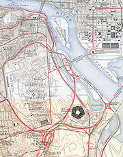
 Arlington Boulevard begins in the east at an interchange with Interstate 66
, Virginia State Route 110
, and the George Washington Memorial Parkway
(I-66 Exit 75) at the foot of the Theodore Roosevelt Bridge
over the Potomac River
to Washington, DC. It proceeds westward soon turning south along the edge of Fort Myer
army
post. Most of the junction
s in this section are grade-separated interchange
s. At an interchange with Washington Boulevard
(VA 27
), the road turns west again and continues in that direction for the remainder of its length.
Arlington Boulevard has interchanges with VA 120
(Glebe Road) in Arlington County and VA 7
(Leesburg Pike)/VA 338
(Hillwood Avenue)/SR 613
(Wilson Boulevard) at Seven Corners
and I-495 (Capital Beltway)
in Fairfax County.
 It terminates just inside Fairfax City at a traffic circle
with US 29
(Lee Highway
and Fairfax Boulevard) and Old Lee Highway. VA 237
, which arrives at the circle as Lee Highway concurrent
with US 29, also concurs with US 50 on Arlington Boulevard for less than 1/3 mile before turning south onto Pickett Road.
 Arlington Boulevard has a shorter history than many other major arterial roads in the region and was only built in the first half of the 20th century in several stages beginning in the west in progressing east. The entire route was complete in 1938 with the final section around Fort Myer. The road was originally called Lee Boulevard but, with Lee Highway
being another major route in Northern Virginia, the name was changed to Arlington Boulevard in the early 1950s.
Between 1935-37, the US 50 designation was attached to the road even though it had yet to be completed past Glebe Road, then VA 9. Before that, the road was VA 236, a number now assigned to the nearby Little River Turnpike.
The completed Arlington Boulevard's eastern terminus was originally the George Washington Memorial Parkway crossing in the District of Columbia at Columbia Island
. With the completion of the Theodore Roosevelt Bridge in 1964, Arlington Boulevard's terminus was moved to its present location.
Arlington Boulevard is undergoing major improvements in Arlington County and "the long-range vision is to transform Arlington Boulevard into a parkway route through the County, one that is made safer for bus riders, bicyclists and pedestrians and one that serves as an appropriate gateway into the County."
Arterial road
An arterial road, or arterial thoroughfare, is a high-capacity urban road. The primary function of an arterial road is to deliver traffic from collector roads to freeways, and between urban centres at the highest level of service possible. As such, many arteries are limited-access roads, or feature...
in Arlington County
Arlington County, Virginia
Arlington County is a county in the Commonwealth of Virginia. The land that became Arlington was originally donated by Virginia to the United States government to form part of the new federal capital district. On February 27, 1801, the United States Congress organized the area as a subdivision of...
, Fairfax County
Fairfax County, Virginia
Fairfax County is a county in Virginia, in the United States. Per the 2010 Census, the population of the county is 1,081,726, making it the most populous jurisdiction in the Commonwealth of Virginia, with 13.5% of Virginia's population...
, and the independent City of Fairfax
Fairfax, Virginia
The City of Fairfax is an independent city forming an enclave within the confines of Fairfax County, in the Commonwealth of Virginia in the United States. Although politically independent of the surrounding county, the City is nevertheless the county seat....
in Northern Virginia
Northern Virginia
Northern Virginia consists of several counties and independent cities in the Commonwealth of Virginia, in a widespread region generally radiating southerly and westward from Washington, D.C...
in metropolitan Washington, DC, United States
United States
The United States of America is a federal constitutional republic comprising fifty states and a federal district...
. It is designated U.S. Route 50
U.S. Route 50 in Virginia
U.S. Route 50 is a transcontinental highway which stretches from Ocean City, Maryland to Sacramento, California. In the U.S. state of Virginia, US 50 extends from the border with Washington DC at a Potomac River crossing at Rosslyn in Arlington County to the West Virginia state line near Gore in...
for its entire length and is part of the National Highway System
National Highway System (United States)
The National Highway System is a network of strategic highways within the United States, including the Interstate Highway System and other roads serving major airports, ports, rail or truck terminals, railway stations, pipeline terminals and other strategic transport facilities.Individual states...
.
Arlington Boulevard serves to bisect Arlington County into its northern and southern sections in popular parlance and for designation of street directional affixes according to the county's street-naming system
Arlington County, Virginia, street-naming system
This article details the street-naming system of Arlington County, Virginia in the United States.Although the streets of Arlington County are not laid out on a grid plan, its local streets follow sequential numbered or alphabetic patterns that are both rational and provide address numbering...
.
Route
Interstate 66
Interstate 66 is an Interstate Highway in the eastern United States. As indicated by its even route number, it runs in an east–west direction. Its western terminus is at Middletown, Virginia, at an intersection with Interstate 81; its eastern terminus is in Washington, D.C., at an...
, Virginia State Route 110
Virginia State Route 110
Virginia State Route 110 is a primary state highway in the U.S. state of Virginia. Known as Jefferson Davis Highway, the state highway runs from U.S. Route 1 and Interstate 395 in Crystal City north to I-66 in Rosslyn within Arlington County...
, and the George Washington Memorial Parkway
George Washington Memorial Parkway
The George Washington Memorial Parkway, known to local motorists simply as the "G.W. Parkway", is a parkway maintained by the U.S. National Park Service. It is located mostly in Northern Virginia, although a short section northwest of the Arlington Memorial Bridge passes over Columbia Island,...
(I-66 Exit 75) at the foot of the Theodore Roosevelt Bridge
Theodore Roosevelt Bridge
The Theodore Roosevelt Bridge is located in Washington, D.C. It carries Interstate 66 and U.S. Highway 50 over the Potomac River near the Kennedy Center, connecting the Rosslyn area of Arlington, Virginia, with Washington...
over the Potomac River
Potomac River
The Potomac River flows into the Chesapeake Bay, located along the mid-Atlantic coast of the United States. The river is approximately long, with a drainage area of about 14,700 square miles...
to Washington, DC. It proceeds westward soon turning south along the edge of Fort Myer
Fort Myer
Fort Myer is a U.S. Army post adjacent to Arlington National Cemetery in Arlington County, Virginia, across the Potomac River from Washington, D.C. It is a small post by U.S...
army
United States Army
The United States Army is the main branch of the United States Armed Forces responsible for land-based military operations. It is the largest and oldest established branch of the U.S. military, and is one of seven U.S. uniformed services...
post. Most of the junction
Junction (traffic)
A junction, when discussed in the context of transport, is a location where traffic can change between different routes, directions, or sometimes modes, of travel.-Historical significance:...
s in this section are grade-separated interchange
Interchange (road)
In the field of road transport, an interchange is a road junction that typically uses grade separation, and one or more ramps, to permit traffic on at least one highway to pass through the junction without directly crossing any other traffic stream. It differs from a standard intersection, at which...
s. At an interchange with Washington Boulevard
Washington Boulevard (Arlington)
Washington Boulevard is a road in Arlington County, Virginia. It begins as a highway, connecting the George Washington Memorial Parkway and Arlington Memorial Bridge with Interstate 395, running past The Pentagon and Arlington National Cemetery...
(VA 27
Virginia State Route 27
State Route 27 is a freeway in Arlington County, Virginia, in the United States. It was built during World War II to connect the Pentagon with U.S. Route 50 and northern Arlington to the west and Washington, DC, to the east. Its route parallels the southern boundaries of Arlington National...
), the road turns west again and continues in that direction for the remainder of its length.
Arlington Boulevard has interchanges with VA 120
Virginia State Route 120
Virginia State Route 120 is a primary state highway in the U.S. state of Virginia. Known as Glebe Road, the state highway runs from U.S. Route 1 in Crystal City north to SR 123 at the Chain Bridge...
(Glebe Road) in Arlington County and VA 7
Virginia State Route 7
State Route 7 is a major primary state highway and busy commuter route in Northern Virginia, United States. It travels southeast from downtown Winchester to State Route 400 in downtown Alexandria...
(Leesburg Pike)/VA 338
Virginia State Route 338
State Route 338 is a primary state highway in the U.S. state of Virginia. It runs from U.S. Route 29/State Route 237 in Falls Church southeast to State Route 7 at Seven Corners. SR 338 was part of U.S. Route 50, and the western end of Arlington Boulevard, until the piece from Seven Corners west to...
(Hillwood Avenue)/SR 613
Virginia State Route 613 (Fairfax County)
State Route 613 is the designation of several distinct suburban surface routes within Fairfax County in the U.S. state of Virginia. These routes were once mostly connected but changes in road alignment, new road construction, and annexations by the independent city of Alexandria have separated them...
(Wilson Boulevard) at Seven Corners
Seven Corners, Virginia
Seven Corners is a commercial center and census-designated place in Fairfax County, Virginia, United States. The population was 8,701 at the 2000 census. Seven Corners has a "Falls Church" mailing address but is not within the independent City of Falls Church, Virginia. The area got its name...
and I-495 (Capital Beltway)
Interstate 495 (Capital Beltway)
Interstate 495 is a Interstate Highway that surrounds the United States' capital of Washington, D.C., and its inner suburbs in adjacent Maryland and Virginia. I-495 is widely known as the Capital Beltway or simply the Beltway, especially when the context of Washington, D.C., is clear...
in Fairfax County.
Traffic circle
A traffic circle or rotary is a type of circular intersection in which traffic must travel in one direction around a central island. In some countries, traffic entering the circle has the right-of-way and drivers in the circle must yield. In many other countries, traffic entering the circle must...
with US 29
U.S. Route 29 in Virginia
U.S. Route 29 is a major north–south route in the Commonwealth of Virginia. It covers from the North Carolina border at the city of Danville to the Key Bridge in Washington, D.C....
(Lee Highway
Lee Highway
The Lee Highway was a National Auto Trail in the United States connecting New York City and San Francisco, California via the South and Southwest. It was named after Robert E...
and Fairfax Boulevard) and Old Lee Highway. VA 237
Virginia State Route 237
State Route 237 is a primary state highway in Virginia. It runs from State Route 236 in Fairfax north on Pickett Road, then west on U.S. Route 50 and east on U.S. Route 29 through Falls Church into Arlington...
, which arrives at the circle as Lee Highway concurrent
Concurrency (road)
A concurrency, overlap, or coincidence in a road network is an instance of one physical road bearing two or more different highway, motorway, or other route numbers...
with US 29, also concurs with US 50 on Arlington Boulevard for less than 1/3 mile before turning south onto Pickett Road.
History
Lee Highway
The Lee Highway was a National Auto Trail in the United States connecting New York City and San Francisco, California via the South and Southwest. It was named after Robert E...
being another major route in Northern Virginia, the name was changed to Arlington Boulevard in the early 1950s.
Between 1935-37, the US 50 designation was attached to the road even though it had yet to be completed past Glebe Road, then VA 9. Before that, the road was VA 236, a number now assigned to the nearby Little River Turnpike.
The completed Arlington Boulevard's eastern terminus was originally the George Washington Memorial Parkway crossing in the District of Columbia at Columbia Island
Columbia Island (District of Columbia)
Columbia Island is located in the Potomac River in Washington, D.C., and is part of the George Washington Memorial Parkway. Boundary Channel separates the island from the Virginia shoreline to the southwest...
. With the completion of the Theodore Roosevelt Bridge in 1964, Arlington Boulevard's terminus was moved to its present location.
Arlington Boulevard is undergoing major improvements in Arlington County and "the long-range vision is to transform Arlington Boulevard into a parkway route through the County, one that is made safer for bus riders, bicyclists and pedestrians and one that serves as an appropriate gateway into the County."