

Virginia Department of Transportation
Encyclopedia
The Virginia Department of Transportation (VDOT) is the agency of state
government responsible for transportation in the state of Virginia
in the United States
. Headquartered in Downtown Richmond
, VDOT is responsible for building, maintaining, and operating the road
s, bridge
s and tunnel
s in the commonwealth
. It is overseen by the Commonwealth Transportation Board
, which has the power to fund airport
s, seaports, rail
and public transport
ation.
VDOT's revised annual budget for Fiscal Year 2010 is $3.38 billion.
By July 1, 2010, VDOT will employ 7,500 full-time employees.
VDOT operates and maintains:
District Notes
VDOT provides the Virginia 511 service, which may be accessed by the 511 telephone number or the www.511va.org Web site. The Virginia 511 system provides traffic camera
s, real-time road and traffic conditions, trip planning, weather information, and alternatives to traveling by car.
northbound between Washington, D.C.
and Richmond
, a distance of 106 miles (170.6 km), without a rest stop. Drivers complained that people who needed to use the restroom would have nowhere to go. VDOT countered that the I-95 corridor is highly developed, and many businesses have restrooms, and that closing the rest stops would save VDOT 9 million dollars toward its 2.6 billion dollar budget deficit.
In January 2010, governor Bob McDonnell
announced that he would reopen all of the closed rest areas as part of his campaign promises. The state is using an "adopt a rest stop" program, pulling 3 million dollars from the reserve maintenance fund, and employing non-violent inmates to help reopen the rest stops. They are all scheduled to reopen on April 17.
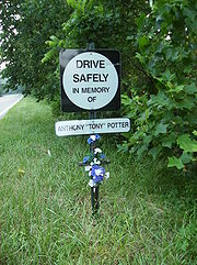 Spontaneous roadside memorial
s, often in the form of white crosses
, Stars of David, bouquets of flowers, and photos of the dead, have been placed along roads at the scenes of fatal accidents. As of July 1, 2003, Virginia law has banned these memorials. Transportation officials have deemed them a threat to the safety of motorists.
Virginia law § 33.1-206.1 prohibits any person from installing a memorial on any highway controlled by the VDOT without a permit. VDOT will install a roadside memorial sign, normally for a period of two years. The sign may not deviate from the standard roadside memorial sign specifications. The cost must by paid by the person requesting the sign.
Not everyone agrees with the new program. Vowing to ignore the program, Del. Robert G. Marshall (R-Prince William), whose son was killed in an auto accident along Interstate 81 in November 2001, said,
By marking an accident site, survivors create "a living memory of this person's life," said Donna Schuurman, president of Association for Death Education and Counseling. Americans have swept the grieving process under the rug, and now it's popping up in public ways that few expected—and that some don't like, according to Ms. Schuurman.
Since then, Virginia has proposed or awarded several PPTA contracts, including:
HOT Lanes
are toll lanes operating alongside existing highway lanes. They provided drivers with a faster and more reliable travel option. Bus
es, carpool
s, motorcycle
s and emergency vehicle
s will be able to use the HOT lanes for free while drivers with fewer than three occupants can use the HOT lanes by paying a toll. The HOT lanes will use dynamic or congestion pricing to manage the number vehicles, and to keep them free-flowing. On average, vehicles are expected to be traveling 55 miles per hour, even during peak travel times.
The first HOT Lanes in the nation to open was the 91 Express Lanes project in Orange County, California
, opening in December 1995. A computer adjusts the toll every six minutes, raising it if too many cars are on the highway, lowering it if the highway is underutilized. Even drivers who won't pay the toll appreciate the HOT lanes diverting traffic form the regular highway.
But many people are not happy about the proposed HOT lanes in Northern Virginia
. In 2001, Maryland
governor Parris N. Glendening (D) stopped a state study of similar proposals for the Maryland side of the Capital Beltway. The governor believed it would be unfair to low-income residents to allow affluent drivers to buy their way out of traffic.
In 2003, Virginia Department of Transportation Commissioner Philip A. Shucet stated that "single drivers could pay $1 to $4 to get off of the congested regular lanes." By 2009, transportation planners in Washington estimated the projected rush-hour toll need to be $1.60 a mile. And, according to VDOT's web site,
Those who own property along the path of the Capital Beltway HOT Lanes are growing increasingly agitated with the project. Supervisor Sharon Bulova
(D-Braddock), who represents a number of neighborhoods affected by the construction, said,
U.S. state
A U.S. state is any one of the 50 federated states of the United States of America that share sovereignty with the federal government. Because of this shared sovereignty, an American is a citizen both of the federal entity and of his or her state of domicile. Four states use the official title of...
government responsible for transportation in the state of Virginia
Virginia
The Commonwealth of Virginia , is a U.S. state on the Atlantic Coast of the Southern United States. Virginia is nicknamed the "Old Dominion" and sometimes the "Mother of Presidents" after the eight U.S. presidents born there...
in the United States
United States
The United States of America is a federal constitutional republic comprising fifty states and a federal district...
. Headquartered in Downtown Richmond
Richmond, Virginia
Richmond is the capital of the Commonwealth of Virginia, in the United States. It is an independent city and not part of any county. Richmond is the center of the Richmond Metropolitan Statistical Area and the Greater Richmond area...
, VDOT is responsible for building, maintaining, and operating the road
Road
A road is a thoroughfare, route, or way on land between two places, which typically has been paved or otherwise improved to allow travel by some conveyance, including a horse, cart, or motor vehicle. Roads consist of one, or sometimes two, roadways each with one or more lanes and also any...
s, bridge
Bridge
A bridge is a structure built to span physical obstacles such as a body of water, valley, or road, for the purpose of providing passage over the obstacle...
s and tunnel
Tunnel
A tunnel is an underground passageway, completely enclosed except for openings for egress, commonly at each end.A tunnel may be for foot or vehicular road traffic, for rail traffic, or for a canal. Some tunnels are aqueducts to supply water for consumption or for hydroelectric stations or are sewers...
s in the commonwealth
Commonwealth
Commonwealth is a traditional English term for a political community founded for the common good. Historically, it has sometimes been synonymous with "republic."More recently it has been used for fraternal associations of some sovereign nations...
. It is overseen by the Commonwealth Transportation Board
Commonwealth Transportation Board
The Commonwealth Transportation Board, formerly the State Highway and Transportation Board, regulates and funds transportation in Virginia. It oversees the Virginia Department of Transportation.-Membership:The Board consists of seventeen members:...
, which has the power to fund airport
Airport
An airport is a location where aircraft such as fixed-wing aircraft, helicopters, and blimps take off and land. Aircraft may be stored or maintained at an airport...
s, seaports, rail
Rail transport
Rail transport is a means of conveyance of passengers and goods by way of wheeled vehicles running on rail tracks. In contrast to road transport, where vehicles merely run on a prepared surface, rail vehicles are also directionally guided by the tracks they run on...
and public transport
Public transport
Public transport is a shared passenger transportation service which is available for use by the general public, as distinct from modes such as taxicab, car pooling or hired buses which are not shared by strangers without private arrangement.Public transport modes include buses, trolleybuses, trams...
ation.
VDOT's revised annual budget for Fiscal Year 2010 is $3.38 billion.
By July 1, 2010, VDOT will employ 7,500 full-time employees.
Responsibilities
- Snow Removal- VDOT is responsible for removing snow along the major roads of Virginia.
VDOT operates and maintains:
- Roads- VDOT's largest responsibility is the maintenance of roads. Filling potholes, storm drainStorm drainA storm drain, storm sewer , stormwater drain or drainage well system or simply a drain or drain system is designed to drain excess rain and ground water from paved streets, parking lots, sidewalks, and roofs. Storm drains vary in design from small residential dry wells to large municipal systems...
cleaning, water drainage, guard rail replacement, bridge work, tree and trash removal, as well as the maintenance of signs and traffic lightTraffic lightTraffic lights, which may also be known as stoplights, traffic lamps, traffic signals, signal lights, robots or semaphore, are signalling devices positioned at road intersections, pedestrian crossings and other locations to control competing flows of traffic...
s.
- More than 12,603 bridgeBridgeA bridge is a structure built to span physical obstacles such as a body of water, valley, or road, for the purpose of providing passage over the obstacle...
s
- Forty-one safety rest areaRest areaA rest area, travel plaza, rest stop, or service area is a public facility, located next to a large thoroughfare such as a highway, expressway, or freeway at which drivers and passengers can rest, eat, or refuel without exiting on to secondary roads...
s and ten welcome centersVisitor centerA visitor center or centre , visitor information center, tourist information center, is a physical location that provides tourist information to the visitors who tour the place or area locally...
along major highways
- More than 100 commuter parking lotParking lotA parking lot , also known as car lot, is a cleared area that is intended for parking vehicles. Usually, the term refers to a dedicated area that has been provided with a durable or semi-durable surface....
s
- Four underwater crossings in the Hampton RoadsHampton RoadsHampton Roads is the name for both a body of water and the Norfolk–Virginia Beach metropolitan area which surrounds it in southeastern Virginia, United States...
area:- The mid-town Elizabeth RiverElizabeth River (Virginia)The Elizabeth River is a tidal estuary forming an arm of Hampton Roads harbor at the southern end of Chesapeake Bay in southeast Virginia in the United States. It is located along the southern side of the mouth of the James River, between the cities of Portsmouth and Norfolk...
tunnel - The downtownDowntown TunnelThe Downtown Tunnel on Interstate 264 crosses the Southern Branch of the Elizabeth River in the South Hampton Roads area. It links the independent City of Portsmouth with the independent City of Norfolk...
Elizabeth RiverElizabeth River (Virginia)The Elizabeth River is a tidal estuary forming an arm of Hampton Roads harbor at the southern end of Chesapeake Bay in southeast Virginia in the United States. It is located along the southern side of the mouth of the James River, between the cities of Portsmouth and Norfolk...
tunnel - The Hampton Roads Bridge-TunnelHampton Roads Bridge-TunnelThe Hampton Roads Bridge-Tunnel is the -long Hampton Roads crossing for Interstate 64 and U.S. Route 60. It is a four-lane facility comprising bridges, trestles, man-made islands, and tunnels under the main shipping channels for Hampton Roads harbor in the southeastern portion of Virginia in the...
on Interstate 64Interstate 64Interstate 64 is an Interstate Highway in the Midwestern and Southeastern United States. Its western terminus is at I-70, U.S. 40, and U.S. 61 in Wentzville, Missouri. Its eastern terminus is at an interchange with I-264 and I-664 at Bowers Hill in Chesapeake, Virginia. As I-64 is concurrent with... - The Monitor-Merrimac Memorial Bridge-TunnelMonitor-Merrimac Memorial Bridge-TunnelMonitor-Merrimac Memorial Bridge-Tunnel is the 4.6 mile-long Hampton Roads crossing for Interstate 664 in the southeastern portion of Virginia in the United States...
on Interstate 664Interstate 664Interstate 664 is an Interstate Highway in the U.S. state of Virginia. The Interstate runs from I-64 and I-264 in Chesapeake north to I-64 in Hampton. I-664 forms the west side of the Hampton Roads Beltway, a circumferential highway serving the Hampton Roads metropolitan area...
- The mid-town Elizabeth River
- Two mountain tunnelTunnelA tunnel is an underground passageway, completely enclosed except for openings for egress, commonly at each end.A tunnel may be for foot or vehicular road traffic, for rail traffic, or for a canal. Some tunnels are aqueducts to supply water for consumption or for hydroelectric stations or are sewers...
s on Interstate 77Interstate 77Interstate 77 is an Interstate Highway in the eastern United States. It traverses diverse terrain, from the mountainous state of West Virginia to the rolling farmlands of North Carolina and Ohio. It largely supplants the old U.S...
in southwest Virginia:- East River Mountain TunnelEast River Mountain TunnelThe East River Mountain Tunnel is a vehicular tunnel that carries Interstate 77 and U.S. Route 52 through East River Mountain between the communities of Bluefield, West Virginia, and Rocky Gap, Virginia.-History:...
- Big Walker Mountain TunnelBig Walker Mountain TunnelThe Big Walker Mountain Tunnel is a vehicular tunnel in the Appalachian Mountains of Southwest Virginia that carries Interstate 77 through/under Big Walker Mountain...
- East River Mountain Tunnel
- Three toll roadToll roadA toll road is a privately or publicly built road for which a driver pays a toll for use. Structures for which tolls are charged include toll bridges and toll tunnels. Non-toll roads are financed using other sources of revenue, most typically fuel tax or general tax funds...
s:- Northern VirginiaNorthern VirginiaNorthern Virginia consists of several counties and independent cities in the Commonwealth of Virginia, in a widespread region generally radiating southerly and westward from Washington, D.C...
's Dulles Toll Road - The Powhite Parkway ExtensionVirginia State Route 76Virginia State Route 76 is a state highway in the U.S. state of Virginia. Known as Powhite Parkway , the state highway runs from SR 652 near Midlothian north to Interstate 195 in Richmond. SR 76 is a toll freeway that connects SR 288, U.S...
near RichmondRichmond, VirginiaRichmond is the capital of the Commonwealth of Virginia, in the United States. It is an independent city and not part of any county. Richmond is the center of the Richmond Metropolitan Statistical Area and the Greater Richmond area...
- Northern Virginia
- One toll bridgeToll bridgeA toll bridge is a bridge over which traffic may pass upon payment of a toll, or fee.- History :The practice of collecting tolls on bridges probably harks back to the days of ferry crossings where people paid a fee to be ferried across stretches of water. As boats became impractical to carry large...
: The George P. Coleman Memorial BridgeGeorge P. Coleman Memorial BridgeThe George P. Coleman Memorial Bridge is a double swing bridge that spans the York River between Yorktown and Gloucester Point, in the U.S. state of Virginia...
- Four ferryFerryA ferry is a form of transportation, usually a boat, but sometimes a ship, used to carry primarily passengers, and sometimes vehicles and cargo as well, across a body of water. Most ferries operate on regular, frequent, return services...
services:- Jamestown FerryJamestown FerryThe Jamestown Ferry is a free automobile and bus ferry service across a navigable portion of the James River in Virginia...
- Sunnybank
- Merry Point
- Hatton FerryHatton FerryHatton Ferry is a cable ferry located 5.5 miles west of Scottsville, Virginia on the James River. It is the last poled ferry in the United States. The ferry crosses the river upstream of Scottsville between Albemarle County and Buckingham County....
(seasonal)
- Jamestown Ferry
Budget
Highway maintenance and operations represent 47 percent of the total budget, followed by 20 percent for highway systems construction. Smaller portions of the budget are directed to address the needs and requirements of debt service, support to other agencies, administration, and earmarks and special financing.Sources
(in millions)| Fiscal Year | Motor Fuels Tax | Vehicle Sales and Use Tax | Vehicle License Tax | Retail Sales and Use Tax | Special General Funds | Toll revenue and Other Sources | Federal | Total |
|---|---|---|---|---|---|---|---|---|
| 2010 | $793 | $363 | $235 | $376 | $766 | $844 | $3,378 | |
| 2009 | $809 | $398 | $235 | $405 | $687 | $915 | $3,448 | |
| 2008 | $843 | $561 | $216 | $422 | $325 | $738 | $910 | $4,014 |
Expenditures
(in millions)| Fiscal Year | Debt Service | Other Agencies & Transfers | Maintenance & Operations | Tolls, Administration, & Other Programs | Public Transportation & Rail | Earmarks & Special Financing | Highway Systems Construction |
|---|---|---|---|---|---|---|---|
| 2010 | $257 | $45 | $1,631 | $396 | $19 | $362 | $669 |
| 2009 | $260 | $45 | $1,525 | $441 | $20 | $258 | $899 |
| 2008 | $263,431,409 | $51 | $1,583 | $471 | $15 | $583 | $1,048 |
Districts
Virginia is divided into nine districts:- Bristol District
- Counties: Bland, Buchanan, Dickenson, Grayson, Lee, Russell, Scott, Smyth, Tazewell, Washington, Wise and Wythe
- Cities: Bristol, Norton
- Salem District
- Counties: Bedford, Botetourt, Carroll, Craig, Floyd, Franklin, Giles, Henry, Montgomery, Patrick, Pulaski and Roanoke
- Cities: Bedford, Galax, Martinsville, Radford, Roanoke and Salem
- Lynchburg District
- Counties: Amherst, Appomattox, Buckingham, Campbell, Charlotte, Cumberland, Halifax, Nelson, Pittsylvania and Prince Edward
- Cities: Danville and Lynchburg
- Richmond District
- Counties: Amelia, Brunswick, Charles City, Chesterfield, Dinwiddie, Goochland, Hanover, Henrico,Henrico county maintains its own county roads Lunenburg, Mecklenburg, New Kent, Nottoway, Powhatan and Prince George
- Cities: Colonial Heights, Hopewell, Petersburg and Richmond
- Hampton Roads DistrictCities in the Hampton Roads district maintain their own roads
- Counties: Accomack Isle of Wight,The town of Smithfield maintains its own roads James City, Northampton, Southampton, Surry, Sussex, York and Greensville
- Cities: Chesapeake, Emporia, Franklin, Hampton, Newport News, Norfolk, Poquoson, Portsmouth, Suffolk, Virginia Beach and Williamsburg
- Fredericksburg District
- Counties: Caroline, Essex, Gloucester, King and Queen, King George, King William, Lancaster, Mathews, Middlesex, Northumberland, Richmond, Spotsylvania, Stafford and Westmoreland
- Cities: Fredericksburg
- Culpeper District
- Counties: Albemarle, Culpeper, Fauquier, Fluvanna, Greene, Louisa, Madison, Orange and Rappahannock
- Cities: Charlottesville
- Staunton District
- Counties: Alleghany, Augusta, Bath, Clarke, Frederick, Highland, Page, Rockbridge, Rockingham, Shenandoah and Warren
- Cities: Buena Vista, Covington, Harrisonburg, Lexington, Staunton, Waynesboro and Winchester
- Northern Virginia District
- Counties: Arlington,Arlington county maintains its own county roads Fairfax, Loudoun and Prince William
- Cities: Alexandria, Fairfax, Falls Church, Manassas and Manassas Park
District Notes
511
Many US states, as well as several US local governments and Canadian provinces provide 511 systems.VDOT provides the Virginia 511 service, which may be accessed by the 511 telephone number or the www.511va.org Web site. The Virginia 511 system provides traffic camera
Traffic camera
A traffic camera is a video camera which observes vehicular traffic on a road. Typically, these are put along major roads such as highways, freeways, motorways, autoroutes and expressways, as well as arterial roads, and are connected with optical fibers buried alongside or even under the road,...
s, real-time road and traffic conditions, trip planning, weather information, and alternatives to traveling by car.
Closing of rest areas
In July 2009, VDOT closed 19 of its rest areas around the state, leaving some stretches of highway, such as the heavily traveled and often congested I-95Interstate 95 in Virginia
In the Commonwealth of Virginia, Interstate 95 runs through the state. It runs concurrently for with Interstate 64 in Richmond, and meets the northern terminus of Interstate 85 in Petersburg. Though Interstate 95 was originally planned to go straight through Washington, D.C., it was instead...
northbound between Washington, D.C.
Washington, D.C.
Washington, D.C., formally the District of Columbia and commonly referred to as Washington, "the District", or simply D.C., is the capital of the United States. On July 16, 1790, the United States Congress approved the creation of a permanent national capital as permitted by the U.S. Constitution....
and Richmond
Richmond, Virginia
Richmond is the capital of the Commonwealth of Virginia, in the United States. It is an independent city and not part of any county. Richmond is the center of the Richmond Metropolitan Statistical Area and the Greater Richmond area...
, a distance of 106 miles (170.6 km), without a rest stop. Drivers complained that people who needed to use the restroom would have nowhere to go. VDOT countered that the I-95 corridor is highly developed, and many businesses have restrooms, and that closing the rest stops would save VDOT 9 million dollars toward its 2.6 billion dollar budget deficit.
In January 2010, governor Bob McDonnell
Bob McDonnell
Robert Francis "Bob" McDonnell is an American politician who has been the 71st Governor of Virginia since January 2010. A former lieutenant colonel in the United States Army, McDonnell served in the Virginia House of Delegates from 1993 to 2006 and served as Attorney General of Virginia from 2006...
announced that he would reopen all of the closed rest areas as part of his campaign promises. The state is using an "adopt a rest stop" program, pulling 3 million dollars from the reserve maintenance fund, and employing non-violent inmates to help reopen the rest stops. They are all scheduled to reopen on April 17.
Roadside memorials
Roadside memorial
A roadside memorial is a marker that usually commemorates a site where a person died suddenly and unexpectedly, away from home. Unlike a grave site headstone, which marks where a body is laid, the memorial marks the last place on earth where a person was alive - although in the past travelers were...
s, often in the form of white crosses
Christian cross
The Christian cross, seen as a representation of the instrument of the crucifixion of Jesus Christ, is the best-known religious symbol of Christianity...
, Stars of David, bouquets of flowers, and photos of the dead, have been placed along roads at the scenes of fatal accidents. As of July 1, 2003, Virginia law has banned these memorials. Transportation officials have deemed them a threat to the safety of motorists.
Virginia law § 33.1-206.1 prohibits any person from installing a memorial on any highway controlled by the VDOT without a permit. VDOT will install a roadside memorial sign, normally for a period of two years. The sign may not deviate from the standard roadside memorial sign specifications. The cost must by paid by the person requesting the sign.
Not everyone agrees with the new program. Vowing to ignore the program, Del. Robert G. Marshall (R-Prince William), whose son was killed in an auto accident along Interstate 81 in November 2001, said,
"This is the bureaucratization of love. I don't like it one bit. I intend to put a cross up for my son. Period."
By marking an accident site, survivors create "a living memory of this person's life," said Donna Schuurman, president of Association for Death Education and Counseling. Americans have swept the grieving process under the rug, and now it's popping up in public ways that few expected—and that some don't like, according to Ms. Schuurman.
HOT Lanes
In 1995, Virginia passed the Public-Private Transportation Act (PPTA), which allows the state to enter into agreements with private entities to construct, improve, maintain and operate transportation facilities.Since then, Virginia has proposed or awarded several PPTA contracts, including:
- Capital Beltway (I-495) HOT Lanes (Started, estimated completion: Late 2012 or 2013)
- 14 miles of four HOV/HOT lanes on the Capital Beltway between the Springfield InterchangeSpringfield InterchangeThe Springfield Interchange, also known as the Mixing Bowl, is the interchange of Interstate 95, Interstate 395, and Interstate 495 in Springfield, Virginia, outside of Washington, D.C....
and just north of the Dulles Toll Road
- 14 miles of four HOV/HOT lanes on the Capital Beltway between the Springfield Interchange
- I-95 / I-395Interstate 395 (District of Columbia-Virginia)Interstate 395 in Washington, D.C., and Virginia is a 13 mile long spur route that begins at a junction with Interstate 95 in Springfield, Virginia and ends in northwest Washington, D.C. It passes underneath the National Mall near the United States Capitol and ends at a junction with U.S...
HOT Lanes (Under negotiation)- 56 miles from the PentagonThe PentagonThe Pentagon is the headquarters of the United States Department of Defense, located in Arlington County, Virginia. As a symbol of the U.S. military, "the Pentagon" is often used metonymically to refer to the Department of Defense rather than the building itself.Designed by the American architect...
to Spotsylvania CountySpotsylvania County, VirginiaAs of the census of 2000, there were 90,395 people, 31,308 households, and 24,639 families residing in the county. The population density was 226 people per square mile . There were 33,329 housing units at an average density of 83 per square mile...
- 56 miles from the Pentagon
HOT Lanes
High occupancy/toll and express toll lanes
High occupancy/toll lanes is a road pricing scheme that gives motorists in single-occupant vehicles access to high-occupancy vehicle lanes . Sometimes, entire roads are designated for the use of HOVs. Tolls are collected either by manned toll booths, automatic number plate recognition, or...
are toll lanes operating alongside existing highway lanes. They provided drivers with a faster and more reliable travel option. Bus
Bus
A bus is a road vehicle designed to carry passengers. Buses can have a capacity as high as 300 passengers. The most common type of bus is the single-decker bus, with larger loads carried by double-decker buses and articulated buses, and smaller loads carried by midibuses and minibuses; coaches are...
es, carpool
Carpool
Carpooling , is the sharing of car journeys so that more than one person travels in a car....
s, motorcycle
Motorcycle
A motorcycle is a single-track, two-wheeled motor vehicle. Motorcycles vary considerably depending on the task for which they are designed, such as long distance travel, navigating congested urban traffic, cruising, sport and racing, or off-road conditions.Motorcycles are one of the most...
s and emergency vehicle
Emergency vehicle
An emergency vehicle is any vehicle that is designated and authorized to respond to an emergency. These vehicles are usually operated by designated agencies, often part of the government, but also run by charities, non-governmental organizations and some commercial companies...
s will be able to use the HOT lanes for free while drivers with fewer than three occupants can use the HOT lanes by paying a toll. The HOT lanes will use dynamic or congestion pricing to manage the number vehicles, and to keep them free-flowing. On average, vehicles are expected to be traveling 55 miles per hour, even during peak travel times.
The first HOT Lanes in the nation to open was the 91 Express Lanes project in Orange County, California
Orange County, California
Orange County is a county in the U.S. state of California. Its county seat is Santa Ana. As of the 2010 census, its population was 3,010,232, up from 2,846,293 at the 2000 census, making it the third most populous county in California, behind Los Angeles County and San Diego County...
, opening in December 1995. A computer adjusts the toll every six minutes, raising it if too many cars are on the highway, lowering it if the highway is underutilized. Even drivers who won't pay the toll appreciate the HOT lanes diverting traffic form the regular highway.
But many people are not happy about the proposed HOT lanes in Northern Virginia
Northern Virginia
Northern Virginia consists of several counties and independent cities in the Commonwealth of Virginia, in a widespread region generally radiating southerly and westward from Washington, D.C...
. In 2001, Maryland
Maryland
Maryland is a U.S. state located in the Mid Atlantic region of the United States, bordering Virginia, West Virginia, and the District of Columbia to its south and west; Pennsylvania to its north; and Delaware to its east...
governor Parris N. Glendening (D) stopped a state study of similar proposals for the Maryland side of the Capital Beltway. The governor believed it would be unfair to low-income residents to allow affluent drivers to buy their way out of traffic.
In 2003, Virginia Department of Transportation Commissioner Philip A. Shucet stated that "single drivers could pay $1 to $4 to get off of the congested regular lanes." By 2009, transportation planners in Washington estimated the projected rush-hour toll need to be $1.60 a mile. And, according to VDOT's web site,
There will be no toll cap, as tolls must be able to increase to the level necessary to manage real-time traffic demand and keep the lanes congestion free.
Those who own property along the path of the Capital Beltway HOT Lanes are growing increasingly agitated with the project. Supervisor Sharon Bulova
Sharon Bulova
Sharon Bulova is currently the chairman of the Fairfax County, Virginia Board of Supervisors after having beaten Republican Pat Herrity in a special election held February 3, 2009. The special election was held to replace fellow Democrat Gerry Connolly who was elected to the US House of...
(D-Braddock), who represents a number of neighborhoods affected by the construction, said,
"Once the project is truly underway, eventually pretty much all the trees in the VDOT right of way are going to be cleared... I know I didn't have an appreciation of the extent of the clearing that was going to be done... Do they really need to clear every teeny piece of vegetation in their right of way?"