

U.S. Route 6
Encyclopedia
U.S. Route 6 also called the Grand Army of the Republic Highway, a name
that honors an American Civil War
veterans association, is a main route of the U.S. Highway system, running east-northeast from Bishop, California
to Provincetown, Massachusetts
. Until 1964, it continued south from Bishop to Long Beach, California
, and was a transcontinental route. After U.S. Route 20
, it is the second-longest U.S. highway in the United States and the longest continuous highway.
. When it was designated in 1926, it only ran east of Erie, Pennsylvania
, and roughly fit into the overall grid (though the diagonal routing of U.S. Route 20
through Erie places it north of US 6). However, subsequent extensions, largely replacing the former U.S. Route 32 and U.S. Route 38 (which were in sequence), have taken it south of U.S. Route 30
near Chicago, Illinois, U.S. Route 40
near Denver, Colorado
(past the end of US 38), U.S. Route 50
at Ely, Nevada
, and even U.S. Route 70
near Los Angeles, California
, due to its north–south alignment in that state.
Since it was pieced together from other routes, US 6 does not serve a major transcontinental corridor, as other highways like U.S. Route 40
do. George R. Stewart
, author of U.S. 40: Cross Section of the United States of America, initially considered US 6, but realized that "Route 6 runs uncertainly from nowhere to nowhere, scarcely to be followed from one end to the other, except by some devoted eccentric". In the famous "beat
" novel
On the Road
by Jack Kerouac
, protagonist Sal Paradise
actually considers hitchhiking
on US 6 to Nevada, but is told by a driver that "there's no traffic passes through 6" and that he'd be better off going via Pittsburgh (the Pennsylvania Turnpike
).
|-
|CA
|41
|66
|-
|NV
|305
|491
|-
|UT
|373
|600
|-
|CO
|467
|752
|-
|NE
|373
|600
|-
|IA
|320
|515
|-
|IL
|172
|277
|-
|IN
|149
|240
|-
|OH
|259
|417
|-
|PA
|394
|634
|-
|NY
|78
|126
|-
|CT
|116
|187
|-
|RI
|25
|40
|-
|MA
|118
|190
|-
|Total
|3205
|5158

is a short, two-lane, north–south surface highway from Bishop
to the Nevada state line. Prior to a 1964 highway renumbering project
, US 6 extended to Long Beach
along what is now US 395
, California 14
, Interstate 5
, Interstate 110
/California 110, and California 1
. Despite the renumbering having removed all freeway portions, it is still part of the California Freeway and Expressway System
. US 6's former routing included a short segment of the famous Arroyo Seco Parkway.
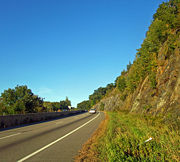
Currently, US 6 begins at US 395 in Bishop and heads north between farms and ranches in the Chalfant Valley
at the base of the 14,000' (4,200 m) western escarpment
of the White Mountains
. After about 30 miles (50 km) Benton
is reached, which has a cafe and gas station. California 120
begins here, heading west past Mono Lake
through Lee Vining
, over Tioga Pass
, and through Yosemite National Park
to the San Joaquin Valley
. US 6 continues north to the Nevada
state line.
, Nevada's highest summit and Montgomery Peak
in California on the right. These twin peaks are the northernmost high summits of the White Mountains
, both over 13000 ft (3,962.4 m). The highway then climbs into the Pinyon
-Juniper
zone and crosses Montgomery Pass 7167 ft (2,184.5 m).
From the pass, US 6 descends into barren shadscale
desert, passing Columbus Salt Marsh
on the left, then merging with US 95
from Coaldale Junction to Tonopah
. Nevada Test and Training Range
begins about 15 mi (24.1 km) southeast of Tonopah.
Just east of Tonopah, US 6 continues east across a series of desert mountain ranges and valleys, including the Monitor Range
. At Warm Springs
, Nevada 375
, also known as the "Extraterrestrial Highway," departs to the southeast and US 6 assumes a northeasterly alignment across the Reveille, Pancake
, Grant
and White Pine Range
s. Rainfall increases eastward, so valleys become less barren and peaks over 11500 ft (3,505.2 m) add scenic interest.
Ely
is the largest town on Route 6 in Nevada. US 50
joins Route 6 at Ely. East of Ely, Routes 6/50 cross the Schell Creek Range
, known for verdant forests and meadows, and for a large deer
and elk
population. The highway descends to the Snake Valley, then crosses the Snake Range
at Sacramento Pass, north of Nevada's second-highest mountain, Wheeler Peak
, where a branch road accesses Great Basin National Park
. Beyond the pass, US 6 passes just north of Baker
, a Mormon
farming community, and reaches the Utah
state line.
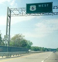
 US 6 enters and leaves Utah concurrent with US 50. However, the two routes are different through the state. US 50 is the newer and shorter route. US 6 is the former route of US 50. US 6 forms an arch-shaped route with Spanish Fork
at the apex
.
for a significant portion of its length from the Utah state line to Denver
. Within the city limits, US 6 follows Denver's 6th Avenue (known as "6th Avenue Freeway"). The highway then travels north briefly, and follows Interstate 76 for most of its length east of Denver. It is unsigned while it is overlapped. The highest altitude along US 6 is 11990 feet (3,654.6 m) at Loveland Pass
, where it crosses the Continental Divide
. It continues down Clear Creek
Valley until it reaches I-70, where it is briefly overlapped until I-70 leaves Clear Creek Valley. US 6 continues down Clear Creek and into Denver, where it turns into a freeway with 6 lanes. East of Denver, it continues east while joined with I-76 until it reaches Sterling
, where it diverges from the interstate. The last town in Colorado it passes is Holyoke
.
. US 6 conjoins with US 34
near Culbertson
, passing through McCook
. US 6 then moves to the northeast, through Hastings
. At Hastings, US 34 diverges and moves north. US 6 parallels Interstate 80
north of Milford
until it reaches Lincoln
. At Lincoln, US 6 becomes Cornhusker Highway, and moves north of I-80, until Gretna
. There US 6 moves due north and becomes West Dodge Road and Dodge Street
in Omaha
. It passes through downtown Omaha on parallel one-way streets and runs concurrent with Interstate 480
in Omaha on its last Nebraska segment. It crosses the Missouri River
into Iowa on a girder bridge completed in 1966 that replaced the Ak-Sar-Ben Bridge
, which was the first road bridge to connect the two cities.
at Council Bluffs
, across the Missouri River from Omaha, Nebraska. It heads due east until Lewis
, where it turns sharply north-northeast to Atlantic
. There, it runs concurrently with US 71
north until I-80. It overlaps with I-80 between US 71 and US 169
at De Soto
. It runs north with US 169 to Adel
, then turns east to go through Des Moines
, where it is also known as Hickman Road joins Iowa Highway 28 at 63rd st and then heads north on Merle Hay
Rd. Then turns East again on Douglas Ave, that turns in to Euclid and then Hubbell Ave. Route 6 is the reason that the north side of Des Moines' major east/west 4 lane street has three different names. At Altoona
, US 6 rejoins I-80. It continues east with I-80 until Newton, where it splits northward from I-80 to run parallel. US 6 passes through Grinnell
and Marengo
before arriving in Iowa City
, where it again crosses I-80. At West Liberty
, it proceeds due east until Wilton
, where it turns north to concurrency again with I-80. Arriving in Davenport
, it becomes Kimberly Road until Interstate 74
, with which it runs across the Mississippi River
on the I-74 Bridge
into Moline, Illinois
.
, US 6 parallels Interstates 74 and 80, mostly along its original routing, overlapping with I-74 for its first 5 miles (8 km) and I-80 for the final 2 miles (5 km) of its routing in Illinois. US 6 directly serves the downtowns of many cities for its length, including Moline
, Geneseo
, Atkinson
, Annawan, Ottawa
, Channahon
, and Joliet
— unlike US 20
, which, in Illinois, mainly consists of freeway sections that bypass the cities US 6 serves. Like nearby U.S. highways 30
and 52
, US 6 avoids the Chicago
city limits.
with Interstates 80 and 94
through Hammond
and Gary
, until Indiana 51 (Exit 15); it then runs south for about 2 miles (3.2 km) and turns east until it meets US 421
in Westville
, then runs south for a mile, then east until it meets US 31
and US 35
, and it shares the same road with US 33
for about 5 miles (8 km) until Ligonier
, where US 33 breaks south toward Fort Wayne
. From there it is mostly two lanes through Indiana until it meets the Ohio state line just east of Butler
. Before the Borman Expressway
was completed, US 6 was on Ridge Road, portions of which are now signed Business US 6.
from Indiana
in Williams County
. It travels just south of Bryan
before it passes through Napoleon
, Bowling Green
, and Fremont
, before turning northeast towards Sandusky Bay
and Lake Erie
. After passing through Sandusky
, the route follows the southern shore of Lake Erie, passing through Huron
and Vermilion
. After crossing the Charles Berry Bridge
in Lorain
, it passes through the western suburbs of Greater Cleveland
as Lake Road in Sheffield Lake, Avon Lake
, Bay Village
, and Rocky River
, and Clifton Boulevard in Lakewood
and the West Blvd./Edgewater neighborhood of Cleveland proper
. US 6 follows the Cleveland Memorial Shoreway
into Downtown Cleveland
, entering downtown by crossing the Detroit-Superior Bridge. US 6 follows Superior Avenue through Public Square
and the East Side of Cleveland before turning east onto Euclid Avenue in East Cleveland
and Chardon Road in the city of Euclid
. US 6 continues eastward through Geauga County
and finally into Ashtabula County
before entering the state of Pennsylvania
slightly north of Pymatuning Reservoir
.
Ohio also has an alternate route of US 6 in the Cleveland area.
between its entrance point 20 miles (32.2 km) west of Meadville
and its exit at Matamoras
. From the Ohio border to US 322
in Conneaut Lake
, the route runs in a southeasterly direction. US 6 then joins US 322 and heads east to Meadville, picking up US 19 west of the city. South of downtown, US 322 splits from the concurrency while US 6 and US 19 remain concurrent through Meadville. The two routes continue northward to Mill Village
, where US 6 and US 19 split at a junction with US 6N
.
For the remainder of its routing in Pennsylvania, US 6 runs roughly parallel to the New York-Pennsylvania border. Along the way, US 6 is concurrent with US 62 for a short distance near Warren
. US 11
joins US 6 from the north in Factoryville
. They run concurrently to Scranton
, where US 11 continues south and US 6 east. At Milford
, US 6 meets US 209
. The two routes embark to the northeast, crossing the Delaware River
from Matamoras
to Port Jervis, New York
.
The 79 miles (127.1 km) portion of US 6 in New York
is located primarily in Orange County
, with lengthy stretches in Putnam
and Westchester
counties, and a small segment in Rockland County
. The route enters the state along with US 209 in Port Jervis
. The two routes split just north of town, with US 209 taking a more northerly route to access Kingston. US 6, in contrast, runs primarily east–west through southern New York.
A section of US 6 runs concurrent with New York State Route 17
(the Quickway, or Southern Tier Expressway) between Goshen
and Harriman
. At Harriman, NY 17 becomes an at-grade road and heads south, while US 6 remains a limited-access highway as it heads east into Harriman State Park. Near the east side of the park, US 6 intersects the Palisades Interstate Parkway
and runs concurrent with it to the Bear Mountain Bridge
, where US 6 is joined by US 202
as it crosses the Hudson River
.
On the other side of the river, US 6 and US 202 run along the Hudson to Peekskill
, where the two routes split, allowing US 6 to continue to the northeast into Putnam County. In Brewster
, US 6 meets US 202 once again. The routes become intertwined once more, running concurrent with one another into Connecticut
.
after crossing from New York, concurrent with US 202
, and ends at the Rhode Island state line in the town of Killingly
. In western Connecticut, US 6 either closely parallels or is concurrent with Interstate 84
, serving as the local route in the suburbs of Danbury, Waterbury
, Bristol
, and Hartford
. It crosses the Connecticut River
(overlapped with I-84 and US 44
) on the Bulkeley Bridge
. In eastern Connecticut, US 6 is one of the principal routes connecting Hartford and Providence, R.I., passing through the small urban areas of Willimantic
and Danielson
. The unsigned portion of the Connecticut Turnpike
then meets with US 6 shortly before crossing the Rhode Island
state line.
(western border with Killingly, CT
) to East Providence
(eastern border with Seekonk, MA
). In and around Providence
, US 6 overlaps with Route 10, as well as US 1A
, US 44
, and Interstates 95
and 195
.
. It parallels I-195 between Providence, R.I., and Wareham
, and serves as the local business route. US 6 continues onto Cape Cod
across the Sagamore Bridge
as a freeway from Bourne
to Orleans
. North of Orleans, it becomes a surface road again to its terminus in Provincetown
.
 The first interstate numbering along the path of US 6 was Route 3 (NE-3) of the New England road marking system, designated in 1922. This route connected Provincetown with the Connecticut-New York border via Providence, Hartford, and Danbury. In late 1925, the Joint Board on Interstate Highways approved the preliminary plan for U.S. Highways. US 6 was restricted to New England
and southeastern New York
, with its vague description matching the existing Route 3 to Danbury, Connecticut
, and heading west from there to U.S. Route 7
at Brewster, New York
. By the time the final plan was approved in late 1926, a second section had been added, from the New York-Pennsylvania border at Port Jervis, New York
west to U.S. Route 120 in Kane, Pennsylvania
. This did not last long, for the April 1927 route log shows the eastern segment running only to the border of New York, short of Brewster, while the western segment was extended in both directions - east to Kingston, New York
, and west to Erie, Pennsylvania
(the latter replacing part of US 120). The western segment was also swapped with U.S. Route 106 between Carbondale and Tunkhannock, Pennsylvania
, taking US 6 through Scranton. The gap through New York was eliminated in 1928 with a new alignment across the state, crossing the Hudson River
on the Bear Mountain Bridge
; the old route between Kingston and Port Jervis became the first U.S. Route 6N.
While US 6 replaced the general corridor of Route 3 in New England, some portions used different alignments. One of these was on Cape Cod
, where Route 3 had used a southerly alignment that is now Route 28
. Instead, US 6 followed the more direct route between Buzzards Bay
and Orleans
that had been the southern extremity of Route 6, and now known as Route 6A
. Farther west, in Connecticut, US 6 ran via South Coventry, while Route 3 had served Andover; the old route became U.S. Route 6A. US 6 is now on the old Route 3, while the South Coventry route now carries Route 31
. A different alignment was also chosen for US 6 between Plainville and Woodbury; Route 3 ran via Milldale and Waterbury, and became parts of Route 14
and Route 10 in the 1932 renumbering. Here US 6 mostly remains on its original routing, with the main difference being between Hartford and Terryville, where US 6 followed the present Route 4
, Route 10, and Route 72
. The final difference was from Danbury west to the New York state line; here US 6 ran straight west, while Route 3 had left the Danbury area to the south, curving to the southwest through Ridgefield to the border. Part of this became U.S. Route 7
, while the rest became Route 35
in 1932.
In New York, US 6 replaced all of Route 37 - known as the "Bridge Route" - over the Bear Mountain Bridge, overlapped part of Route 17, and was assigned to an unnumbered road from Middletown
west to Port Jervis. The original route, which soon became US 6N, replaced Route 50, and is now part of U.S. Route 209. The part of US 6 in Pennsylvania replaced Route 7, also known as the Roosevelt Highway, an auto trail
. The Roosevelt Highway Association extended the name east with US 6 to Cape Cod by 1930.
, and U.S. Route 38 from Lincoln, Nebraska
, to Greeley, Colorado
. As part of the fine-tuning during 1926, US 38 was extended east from Lincoln to Omaha, allowing U.S. Route 77
, which had been assigned to this road, to extend north to Sioux City. These routes, which now connected end-to-end at Omaha, replaced a large portion of the Detroit-Lincoln-Denver Highway, which split at Princeton to bypass Chicago to the south via Joliet. They followed existing state highways: 2 and 14 in Colorado, 7 in Nebraska, 2 and 7 in Iowa, and 7 and 18 in Illinois.
Most of US 32 and all of US 38 became a western extension of US 6 on June 8, 1931, and the Roosevelt Highway name followed. To connect western Pennsylvania to central Indiana, relatively minor roads (including the route for SR 6 in Indiana) were used, except west of Joliet, where it used a part of the old Detroit-Lincoln-Denver Highway. The short stub to Erie formed at the old west end became U.S. Route 6N, and US 32 remained in Illinois, running independently from Chicago to Princeton and overlapping US 6 to Davenport, Iowa
. US 32 has since been absorbed into U.S. Route 34
.
The Roosevelt Highway Association continued to push for an extension, and in December 1936 the American Association of State Highway Officials made US 6 (and thus the Roosevelt Highway) a transcontinental route from Cape Cod, Massachusetts to Long Beach, California
. It took a new route from Wiggins, Colorado
, southwest to Denver (the old route to Greeley became an extended U.S. Route 34
) and west over the Rocky Mountains
to Leadville, overlapping U.S. Route 24
to Grand Junction and U.S. Route 50
to Spanish Fork, Utah
. From Spanish Fork to Ely, Nevada
, it followed a roadway that had yet to be improved in areas; the rest of the route, from Ely to Southern California
, followed the old Midland Trail
, running almost north–south in California. The unimproved segment from Ely east to Delta, Utah
, about 160 miles (260 km) long, was, according to Business Week, "nothing but a wagon trail-rutted, filled with dust...one of the worst chunks of federal [sic] road in the country." Paving was completed in September 1952, with a two-day celebration in Delta marking the occasion.
Major William L. Anderson, Jr. of the U.S. Army recommended that US 6 be designated the Grand Army of the Republic Highway, honoring the Union soldiers in the Civil War. The Sons of Union Veterans of the Civil War
began pushing for the name in April 1934. Massachusetts, the first state to apply the name, passed a law to do so on February 2, 1937; it was not until at least 1948 that all states had agreed. The highway was formally dedicated at the Long Beach end on May 3, 1953, though the Roosevelt Highway Association continued to exist at least through the 1960s.
at Bishop. The portion that did not overlap other routes, including US 395 and State Route 11, was redesignated State Route 14.
Starting in the spring of 1983 U.S. 6 was a discontinuous route for almost one year, due to a massive landslide that destroyed the town of Thistle, Utah
. The highway was rebuilt by blasting a path higher up the canyon wall. The landslide remains the most costly in the history of the United States.
Grand Army of the Republic
The Grand Army of the Republic was a fraternal organization composed of veterans of the Union Army, US Navy, US Marines and US Revenue Cutter Service who served in the American Civil War. Founded in 1866 in Decatur, Illinois, it was dissolved in 1956 when its last member died...
that honors an American Civil War
American Civil War
The American Civil War was a civil war fought in the United States of America. In response to the election of Abraham Lincoln as President of the United States, 11 southern slave states declared their secession from the United States and formed the Confederate States of America ; the other 25...
veterans association, is a main route of the U.S. Highway system, running east-northeast from Bishop, California
Bishop, California
Bishop is a city in Inyo County, California, United States. Though Bishop is the only city and the largest populated place in Inyo County, the county seat is Independence. Bishop is located near the northern end of the Owens Valley, at an elevation of 4147 feet . The population was 3,879 at the...
to Provincetown, Massachusetts
Provincetown, Massachusetts
Provincetown is a New England town located at the extreme tip of Cape Cod in Barnstable County, Massachusetts, United States. The population was 3,431 at the 2000 census, with an estimated 2007 population of 3,174...
. Until 1964, it continued south from Bishop to Long Beach, California
Long Beach, California
Long Beach is a city situated in Los Angeles County in Southern California, on the Pacific coast of the United States. The city is the 36th-largest city in the nation and the seventh-largest in California. As of 2010, its population was 462,257...
, and was a transcontinental route. After U.S. Route 20
U.S. Route 20
U.S. Route 20 is an east–west United States highway. As the "0" in its route number implies, US 20 is a coast-to-coast route. Spanning , it is the longest road in the United States, and the route sparsely parallels Interstate 90...
, it is the second-longest U.S. highway in the United States and the longest continuous highway.
Route description
From 1936 until 1964, when most of its route through California was eliminated, US 6 was the longest highway in the country, but the truncation dropped its length below that of U.S. Route 20U.S. Route 20
U.S. Route 20 is an east–west United States highway. As the "0" in its route number implies, US 20 is a coast-to-coast route. Spanning , it is the longest road in the United States, and the route sparsely parallels Interstate 90...
. When it was designated in 1926, it only ran east of Erie, Pennsylvania
Erie, Pennsylvania
Erie is a city located in northwestern Pennsylvania in the United States. Named for the lake and the Native American tribe that resided along its southern shore, Erie is the state's fourth-largest city , with a population of 102,000...
, and roughly fit into the overall grid (though the diagonal routing of U.S. Route 20
U.S. Route 20
U.S. Route 20 is an east–west United States highway. As the "0" in its route number implies, US 20 is a coast-to-coast route. Spanning , it is the longest road in the United States, and the route sparsely parallels Interstate 90...
through Erie places it north of US 6). However, subsequent extensions, largely replacing the former U.S. Route 32 and U.S. Route 38 (which were in sequence), have taken it south of U.S. Route 30
U.S. Route 30
U.S. Route 30 is an east–west main route of the system of United States Numbered Highways, with the highway traveling across the northern tier of the country. It is the third longest U.S. route, after U.S. Route 20 and U.S. Route 6. The western end of the highway is at Astoria, Oregon; the...
near Chicago, Illinois, U.S. Route 40
U.S. Route 40
U.S. Route 40 is an east–west United States highway. As with most routes whose numbers end in a zero, U.S. 40 once traversed the entire United States. It is one of the original 1920s U.S. Highways, and its first termini were San Francisco, California, and Atlantic City, New Jersey...
near Denver, Colorado
Denver, Colorado
The City and County of Denver is the capital and the most populous city of the U.S. state of Colorado. Denver is a consolidated city-county, located in the South Platte River Valley on the western edge of the High Plains just east of the Front Range of the Rocky Mountains...
(past the end of US 38), U.S. Route 50
U.S. Route 50
U.S. Route 50 is a major east–west route of the U.S. Highway system, stretching just over from Ocean City, Maryland on the Atlantic Ocean to West Sacramento, California. Until 1972, when it was replaced by Interstate Highways west of the Sacramento area, it extended to San Francisco, near...
at Ely, Nevada
Ely, Nevada
Ely is the largest city and county seat of White Pine County, Nevada, United States. Ely was founded as a stagecoach station along the Pony Express and Central Overland Route. Ely's mining boom came later than the other towns along US 50, with the discovery of copper in 1906...
, and even U.S. Route 70
U.S. Route 70
U.S. Route 70 is an east–west United States highway that runs for 2,385 miles from eastern North Carolina to east-central Arizona. As can be derived from its number, it is a major east–west highway of the Southern and Southwestern United States...
near Los Angeles, California
Los Angeles, California
Los Angeles , with a population at the 2010 United States Census of 3,792,621, is the most populous city in California, USA and the second most populous in the United States, after New York City. It has an area of , and is located in Southern California...
, due to its north–south alignment in that state.
Since it was pieced together from other routes, US 6 does not serve a major transcontinental corridor, as other highways like U.S. Route 40
U.S. Route 40
U.S. Route 40 is an east–west United States highway. As with most routes whose numbers end in a zero, U.S. 40 once traversed the entire United States. It is one of the original 1920s U.S. Highways, and its first termini were San Francisco, California, and Atlantic City, New Jersey...
do. George R. Stewart
George R. Stewart
George Rippey Stewart was an American toponymist, a novelist, and a professor of English at the University of California, Berkeley...
, author of U.S. 40: Cross Section of the United States of America, initially considered US 6, but realized that "Route 6 runs uncertainly from nowhere to nowhere, scarcely to be followed from one end to the other, except by some devoted eccentric". In the famous "beat
Beat generation
The Beat Generation refers to a group of American post-WWII writers who came to prominence in the 1950s, as well as the cultural phenomena that they both documented and inspired...
" novel
Novel
A novel is a book of long narrative in literary prose. The genre has historical roots both in the fields of the medieval and early modern romance and in the tradition of the novella. The latter supplied the present generic term in the late 18th century....
On the Road
On the Road
On the Road is a novel by American writer Jack Kerouac, written in April 1951, and published by Viking Press in 1957. It is a largely autobiographical work that was based on the spontaneous road trips of Kerouac and his friends across mid-century America. It is often considered a defining work of...
by Jack Kerouac
Jack Kerouac
Jean-Louis "Jack" Lebris de Kerouac was an American novelist and poet. He is considered a literary iconoclast and, alongside William S. Burroughs and Allen Ginsberg, a pioneer of the Beat Generation. Kerouac is recognized for his spontaneous method of writing, covering topics such as Catholic...
, protagonist Sal Paradise
Sal Paradise
Salvatore “Sal” Paradise is the narrator and the protagonist in Jack Kerouac's novel On the Road. Sal, an Italian American youth living in New Jersey with his aunt, is an uninspired writer working on a book who follows and accompanies Dean Moriarty, a young and reckless Denver vagrant, on his...
actually considers hitchhiking
Hitchhiking
Hitchhiking is a means of transportation that is gained by asking people, usually strangers, for a ride in their automobile or other road vehicle to travel a distance that may either be short or long...
on US 6 to Nevada, but is told by a driver that "there's no traffic passes through 6" and that he'd be better off going via Pittsburgh (the Pennsylvania Turnpike
Pennsylvania Turnpike
The Pennsylvania Turnpike is a toll highway system operated by the Pennsylvania Turnpike Commission in the Commonwealth of Pennsylvania, United States. The three sections of the turnpike system total . The main section extends from Ohio to New Jersey and is long...
).
|-
|CA
U.S. Route 6 in California
U.S. Route 6, or US 6, is a transcontinental highway from the U.S. state of California to Massachusetts. In California, the highway lies in the eastern portion of the state from Bishop in the Owens Valley north to the Nevada state line in Esmeralda County...
|41
|66
|-
|NV
U.S. Route 6 in Nevada
In the U.S. state of Nevada, U.S. Route 6 cuts across the middle portion of the state, serving the cities of Tonopah and Ely, en route to Utah and points further east....
|305
|491
|-
|UT
U.S. Route 6 in Utah
U.S. Route 6 is a major east–west state highway through the central part of the U.S. state of Utah. Although it is about longer than US-50, it serves more populated areas, and in fact follows what had been US-50's routing until it was moved to follow I-70 in 1976...
|373
|600
|-
|CO
U.S. Route 6 in Colorado
In the U.S. state of Colorado, U.S. Route 6 is an east–west highway stretching from Colorado to Nebraska. Much of the route overlaps other highways in Colorado, and as a result, much of US 6 is unsigned.- Route description :...
|467
|752
|-
|NE
U.S. Route 6 in Nebraska
In the U.S. State of Nebraska, U.S. Highway 6 is a highway which goes from the Colorado border west of Imperial in the west to the Iowa border in the east at Omaha. Significant portions of the highway are concurrent with other highways, most significantly, U.S. Highway 34 between Culbertson and...
|373
|600
|-
|IA
U.S. Route 6 in Iowa
U.S. Route 6 is an east–west U.S. highway which runs across the U.S. state of Iowa. It is signed in places as the Grand Army of the Republic Highway. Like all state highways in Iowa, it is maintained by the Iowa Department of Transportation. The route begins at the Missouri River...
|320
|515
|-
|IL
U.S. Route 6 in Illinois
In the state of Illinois, U.S. Route 6 is an east–west arterial surface road that runs from the city of Moline in the Quad Cities area to Lansing at the Indiana state line. This is a distance of approximately .-Quad Cities to LaSalle–Peru:...
|172
|277
|-
|IN
U.S. Route 6 in Indiana
U.S. Route 6 is a part of the United States Numbered Highway that runs from California to Provincetown, Massachusetts. In Indiana, it is a mostly rural, two-lane route that travels in the northern part of the state. However, some four-lane stretches may be found in Lake and Porter counties. For...
|149
|240
|-
|OH
|259
|417
|-
|PA
U.S. Route 6 in Pennsylvania
U.S. Route 6 travels east–west near the north edge of the U.S. state of Pennsylvania from the Ohio state line near Pymatuning Reservoir east to the Mid-Delaware Bridge over the Delaware River into Port Jervis, New York. It is the longest highway segment in the Commonwealth. Most of it is a...
|394
|634
|-
|NY
U.S. Route 6 in New York
U.S. Route 6 is a part of the U.S. Highway System that runs from Bishop, California, to Provincetown, Massachusetts. In New York, US 6 extends from the Pennsylvania state line at Port Jervis to the Connecticut state line east of Brewster...
|78
|126
|-
|CT
U.S. Route 6 in Connecticut
U.S. Route 6 is the portion of the cross-country U.S. Route 6 within the state of Connecticut. West of Hartford, the route either closely parallels or runs along Interstate 84. Interstate 84 has largely supplanted Route 6 as a through route in western Connecticut. East of Hartford, the route serves...
|116
|187
|-
|RI
U.S. Route 6 in Rhode Island
U.S. Route 6 is a major east–west road in the U.S. state of Rhode Island. Nationally, the route continues west to Bishop, California and east to Provincetown, Massachusetts. In western Rhode Island, it forms part of one of several routes between Hartford, Connecticut and Providence, Rhode...
|25
|40
|-
|MA
U.S. Route 6 in Massachusetts
Route 6 is the portion of the cross-country U.S. Route 6 in the state of Massachusetts. Route 6 runs in the state connecting Providence, Rhode Island to Fall River, New Bedford, and Cape Cod. In the Fall River and New Bedford areas, Route 6 is a secondary highway paralleling Interstate 195...
|118
|190
|-
|Total
|3205
|5158
California
The modern US 6 in CaliforniaCalifornia
California is a state located on the West Coast of the United States. It is by far the most populous U.S. state, and the third-largest by land area...
is a short, two-lane, north–south surface highway from Bishop
Bishop, California
Bishop is a city in Inyo County, California, United States. Though Bishop is the only city and the largest populated place in Inyo County, the county seat is Independence. Bishop is located near the northern end of the Owens Valley, at an elevation of 4147 feet . The population was 3,879 at the...
to the Nevada state line. Prior to a 1964 highway renumbering project
1964 state highway renumbering (California)
In 1963 and 1964, the California Division of Highways implemented a major renumbering of its state highways. The majority of sign routes — those marked for the public — kept their numbers; the main changes were to the legislative routes, which had their numbers changed to match the sign routes...
, US 6 extended to Long Beach
Long Beach, California
Long Beach is a city situated in Los Angeles County in Southern California, on the Pacific coast of the United States. The city is the 36th-largest city in the nation and the seventh-largest in California. As of 2010, its population was 462,257...
along what is now US 395
U.S. Route 395
U.S. Route 395 is a U.S. Route in the western United States. The southern terminus of the route is in the Mojave Desert at Interstate 15 near Hesperia. The northern terminus is at the Canadian border near Laurier, where the road becomes Highway 395 upon entering British Columbia. At one time, the...
, California 14
California State Route 14
State Route 14 is a north–south state highway in the U.S. state of California, largely in the Mojave Desert. The southern portion of the highway is signed as the Antelope Valley Freeway. The route connects Interstate 5, or Golden State Freeway, near Santa Clarita and with U.S. Route 395 near...
, Interstate 5
Interstate 5
Interstate 5 is the main Interstate Highway on the West Coast of the United States, running largely parallel to the Pacific Ocean coastline from Canada to Mexico . It serves some of the largest cities on the U.S...
, Interstate 110
Interstate 110 (California)
Route 110, consisting of two segments of State Route 110 joined by Interstate 110 , is a state highway in the Los Angeles area of the U.S. state of California, mostly built to freeway standards...
/California 110, and California 1
California State Route 1
State Route 1 , more often called Highway 1, is a state highway that runs along much of the Pacific coast of the U.S. state of California. It is famous for running along some of the most beautiful coastlines in the world, leading to its designation as an All-American Road.Highway 1 does not run...
. Despite the renumbering having removed all freeway portions, it is still part of the California Freeway and Expressway System
California Freeway and Expressway System
The California Freeway and Expressway System is a system of existing or planned freeways and expressways in the U.S. state of California. It is defined by the Streets and Highways Code.-List of roads in the system:*State Route 1 *State Route 2...
. US 6's former routing included a short segment of the famous Arroyo Seco Parkway.
Currently, US 6 begins at US 395 in Bishop and heads north between farms and ranches in the Chalfant Valley
Chalfant Valley, California
Chalfant is a census-designated place in Mono County, California. It is located on the abandoned Southern Pacific Railroad south-southeast of Benton, at an elevation of 4258 feet . The population was 651 at the 2010 census.Chalfant is a small, primarily residential community located north of the...
at the base of the 14,000' (4,200 m) western escarpment
Escarpment
An escarpment is a steep slope or long cliff that occurs from erosion or faulting and separates two relatively level areas of differing elevations.-Description and variants:...
of the White Mountains
White Mountains (California)
The White Mountains of California are a triangular fault block mountain range facing the Sierra Nevada across the upper Owens Valley. They extend for approximately as a greatly elevated plateau about wide on the south, narrowing to a point at the north, with elevations generally increasing...
. After about 30 miles (50 km) Benton
Benton, California
Benton is a census-designated place in Mono County, California, United States. It is located 3 miles east-northeast of the community of Benton Hot Springs and north of the community of Bishop, at an elevation of 5387 feet...
is reached, which has a cafe and gas station. California 120
California State Route 120
State Route 120 , in northern California, runs between the Central Valley near Manteca, through Yosemite National Park, and ends at U.S. Route 6 in Mono County.-Route description:...
begins here, heading west past Mono Lake
Mono Lake
Mono Lake is a large, shallow saline lake in Mono County, California, formed at least 760,000 years ago as a terminal lake in a basin that has no outlet to the ocean...
through Lee Vining
Lee Vining, California
Lee Vining is a census-designated place in Mono County, California, United States. It is located south-southeast of Bridgeport, at an elevation of 6781 feet . Lee Vining is located on the southwest shore of Mono Lake. The population was 222 as of the 2010 census, down from 250 reported as of 2000...
, over Tioga Pass
Tioga Pass
Tioga Pass is a mountain pass in the Sierra Nevada mountains of California. State Route 120 runs through it, and serves as the eastern entry point for Yosemite National Park. It is the highest highway pass in California and in the Sierra Nevada. Mount Dana is to the east of the pass...
, and through Yosemite National Park
Yosemite National Park
Yosemite National Park is a United States National Park spanning eastern portions of Tuolumne, Mariposa and Madera counties in east central California, United States. The park covers an area of and reaches across the western slopes of the Sierra Nevada mountain chain...
to the San Joaquin Valley
San Joaquin Valley
The San Joaquin Valley is the area of the Central Valley of California that lies south of the Sacramento – San Joaquin River Delta in Stockton...
. US 6 continues north to the Nevada
Nevada
Nevada is a state in the western, mountain west, and southwestern regions of the United States. With an area of and a population of about 2.7 million, it is the 7th-largest and 35th-most populous state. Over two-thirds of Nevada's people live in the Las Vegas metropolitan area, which contains its...
state line.
Nevada
From the California border, US 6 heads northeast through semi-desert Queen Valley with Boundary Peak (Nevada)Boundary Peak (Nevada)
Boundary Peak is the highest summit in U. S. state of Nevada and is located in Esmeralda County. It is the northernmost peak over 13,000 feet in the White Mountains. At the peak is within the state of Nevada, although it is only about half a mile from the California border...
, Nevada's highest summit and Montgomery Peak
Montgomery Peak
Montgomery Peak is a mountain in the White Mountains of California, USA. It is less than from Boundary Peak, the highest point in Nevada. It can be climbed in combination with Boundary Peak....
in California on the right. These twin peaks are the northernmost high summits of the White Mountains
White Mountains (California)
The White Mountains of California are a triangular fault block mountain range facing the Sierra Nevada across the upper Owens Valley. They extend for approximately as a greatly elevated plateau about wide on the south, narrowing to a point at the north, with elevations generally increasing...
, both over 13000 ft (3,962.4 m). The highway then climbs into the Pinyon
Single-leaf Pinyon
The Single-leaf Pinyon, ', is a pine in the pinyon pine group, native to the United States and northwest Mexico. The range is in southernmost Idaho, western Utah, Arizona, southwest New Mexico, Nevada, eastern and southern California and northern Baja California.It occurs at moderate altitudes from...
-Juniper
Juniperus osteosperma
Juniperus osteosperma is a shrub or small tree reaching 3-6 m tall. It is native to the southwestern United States, in Utah, Nevada, Arizona, western New Mexico, western Colorado, Wyoming, southern Montana, southern Idaho and eastern California...
zone and crosses Montgomery Pass 7167 ft (2,184.5 m).
From the pass, US 6 descends into barren shadscale
Atriplex confertifolia
Atriplex confertifolia is a species of evergreen shrub in the Chenopodiaceae family, which is native to the western United States.-Habitat:Shadscale is a common, often dominant, shrub in the lowest and driest areas of the Great Basin...
desert, passing Columbus Salt Marsh
Columbus, Nevada
Columbus was a borax mining boom town in Esmeralda County. Its remnants are located on the edge of the Columbus Salt Marsh.-History:Settlement came to the Columbus Salt Marsh in 1865 with the raising of a quartz mill. Columbus was the ideal location for a mill, as it was the only stop for several...
on the left, then merging with US 95
U.S. Route 95
U.S. Route 95 is a north–south U.S. highway in the western United States. Unlike many other US highways, it has not seen deletion or replacement on most of its length by an encroaching Interstate highway corridor, due to its mostly rural course...
from Coaldale Junction to Tonopah
Tonopah, Nevada
Tonopah is a census-designated place located in and the county seat of Nye County, Nevada. It is located at the junction of U.S. Routes 6 and 95 approximately mid-way between Las Vegas and Reno....
. Nevada Test and Training Range
Nevada Test and Training Range
The Nevada Test and Training Range is a training facility of the United States Air Force located in the desert of southern Nevada in the United States. It is the largest of its kind in the US, and is operated by the USAF Warfare Center's 98th Range Wing...
begins about 15 mi (24.1 km) southeast of Tonopah.
Just east of Tonopah, US 6 continues east across a series of desert mountain ranges and valleys, including the Monitor Range
Monitor Range
The Monitor Range is located in south-central Nevada in the United States. The range lies west and northwest of the Hot Creek Range and north of Highway 6 in Nye County, and extends for approximately 106 miles into Eureka County at its northern end.The Forest Service is in charge of 83.6% of the...
. At Warm Springs
Warm Springs, Nevada
Warm Springs is an unincorporated community in the Tonopah Basin and Nye County, Nevada, near the mountain pass which divides the Kawich and Hot Creek ranges . It is located at the junction of U.S...
, Nevada 375
Nevada State Route 375
State Route 375 is a state highway in south-central Nevada in the United States. The highway stretches from State Route 318 at Crystal Springs northwest to U.S. Route 6 at Warm Springs. The route travels through mostly unoccupied desert terrain, with much of its alignment paralleling the...
, also known as the "Extraterrestrial Highway," departs to the southeast and US 6 assumes a northeasterly alignment across the Reveille, Pancake
Pancake Range
The Pancake Range is located in east-central Nevada in the United States. The mountains lie in a generally north-south direction in Nye County and White Pine County. The Lunar Crater Volcanic Field lies at the southwestern end of the chain...
, Grant
Grant Range
The Grant Range is a mountain chain in east-central Nevada in the western United States. It runs for approximately 30 miles in a generally north-south direction in northeastern Nye County. It is located south of the Horse Range and northeast of the closely associated Quinn Canyon Range. To the...
and White Pine Range
White Pine Range
The White Pine Range is a group of mountains in southern White Pine County, in eastern Nevada. The range runs for approximately 51 miles from Beck Pass in the north to Currant Pass in the south. To the west of the range are the Duckwater tribal lands and the northern arm of large Railroad Valley...
s. Rainfall increases eastward, so valleys become less barren and peaks over 11500 ft (3,505.2 m) add scenic interest.
Ely
Ely, Nevada
Ely is the largest city and county seat of White Pine County, Nevada, United States. Ely was founded as a stagecoach station along the Pony Express and Central Overland Route. Ely's mining boom came later than the other towns along US 50, with the discovery of copper in 1906...
is the largest town on Route 6 in Nevada. US 50
U.S. Route 50
U.S. Route 50 is a major east–west route of the U.S. Highway system, stretching just over from Ocean City, Maryland on the Atlantic Ocean to West Sacramento, California. Until 1972, when it was replaced by Interstate Highways west of the Sacramento area, it extended to San Francisco, near...
joins Route 6 at Ely. East of Ely, Routes 6/50 cross the Schell Creek Range
Schell Creek Range
The Schell Creek Range is a linear mountain range in central White Pine County, in east-central Nevada. Its length is approximately in a north-south direction....
, known for verdant forests and meadows, and for a large deer
Mule Deer
The mule deer is a deer indigenous to western North America. The Mule Deer gets its name from its large mule-like ears. There are believed to be several subspecies, including the black-tailed deer...
and elk
Elk
The Elk is the large deer, also called Cervus canadensis or wapiti, of North America and eastern Asia.Elk may also refer to:Other antlered mammals:...
population. The highway descends to the Snake Valley, then crosses the Snake Range
Snake Range
The Snake Range is a line of high mountains in eastern White Pine County, in east-central Nevada in the western United States. Typical of other ranges in the Basin and Range Province, it runs in a north-south direction, in this case for approximately...
at Sacramento Pass, north of Nevada's second-highest mountain, Wheeler Peak
Wheeler Peak
Wheeler Peak may refer to the following United States summits:*Wheeler BM, a benchmark Nevada summit north-northwest of Wheeler Pass: *Wheeler Peak *Wheeler Peak , on the Wheeler Crest:...
, where a branch road accesses Great Basin National Park
Great Basin National Park
Great Basin National Park is a United States National Park established in 1986, located in east-central Nevada near the Utah border. The park derives its name from the Great Basin, the dry and mountainous region between the Sierra Nevada and the Wasatch Mountains. Topographically, this area is...
. Beyond the pass, US 6 passes just north of Baker
Baker, Nevada
Baker, Nevada is a small community and census-designated place in White Pine County, Nevada. It is located from Great Basin National Park on State Route 487. The town is named after an early settler, George W. Baker...
, a Mormon
Mormon
The term Mormon most commonly denotes an adherent, practitioner, follower, or constituent of Mormonism, which is the largest branch of the Latter Day Saint movement in restorationist Christianity...
farming community, and reaches the Utah
Utah
Utah is a state in the Western United States. It was the 45th state to join the Union, on January 4, 1896. Approximately 80% of Utah's 2,763,885 people live along the Wasatch Front, centering on Salt Lake City. This leaves vast expanses of the state nearly uninhabited, making the population the...
state line.
Utah
Spanish Fork, Utah
Spanish Fork is a city in Utah County, Utah, United States. It is part of the Provo–Orem, Utah Metropolitan Statistical Area. The population was 31,497 as of the 2008 census estimate.-History:Spanish Fork was settled by LDS pioneers in 1851...
at the apex
Apex (geometry)
In geometry, an apex is the vertex which is in some sense the highest of the figure to which it belongs.*In an isosceles triangle, the apex is the vertex where the two sides of equal length meet, opposite the unequal third side....
.
Colorado
US 6 is concurrent with Interstate 70Interstate 70
Interstate 70 is an Interstate Highway in the United States that runs from Interstate 15 near Cove Fort, Utah, to a Park and Ride near Baltimore, Maryland. It was the first Interstate Highway project in the United States. I-70 approximately traces the path of U.S. Route 40 east of the Rocky...
for a significant portion of its length from the Utah state line to Denver
Denver, Colorado
The City and County of Denver is the capital and the most populous city of the U.S. state of Colorado. Denver is a consolidated city-county, located in the South Platte River Valley on the western edge of the High Plains just east of the Front Range of the Rocky Mountains...
. Within the city limits, US 6 follows Denver's 6th Avenue (known as "6th Avenue Freeway"). The highway then travels north briefly, and follows Interstate 76 for most of its length east of Denver. It is unsigned while it is overlapped. The highest altitude along US 6 is 11990 feet (3,654.6 m) at Loveland Pass
Loveland Pass
Loveland Pass, elevation 11,990 ft. above sea level, is a high mountain pass in the Rocky Mountains of north-central Colorado, U.S.A.....
, where it crosses the Continental Divide
Continental Divide
The Continental Divide of the Americas, or merely the Continental Gulf of Division or Great Divide, is the name given to the principal, and largely mountainous, hydrological divide of the Americas that separates the watersheds that drain into the Pacific Ocean from those river systems that drain...
. It continues down Clear Creek
Clear Creek (Colorado)
Clear Creek is a tributary of the South Platte River, approximately long, in north central Colorado in the United States. The creek flows through Clear Creek Canyon in the Rocky Mountains directly west of Denver, descending through a long gorge to emerge on the Colorado Eastern Plains where it...
Valley until it reaches I-70, where it is briefly overlapped until I-70 leaves Clear Creek Valley. US 6 continues down Clear Creek and into Denver, where it turns into a freeway with 6 lanes. East of Denver, it continues east while joined with I-76 until it reaches Sterling
Sterling, Colorado
The City of Sterling is a Home Rule Municipality that is the county seat and the most populous city of Logan County, Colorado, United States. The city population was 14,777 at the 2010 census.-Geography:Sterling is located at...
, where it diverges from the interstate. The last town in Colorado it passes is Holyoke
Holyoke, Colorado
The City of Holyoke is a Home Rule Municipality that is the county seat and the most populous city of Phillips County, Colorado, United States. The city population was 2,261 at the 2000 census.-Geography:Holyoke is located at ....
.
Nebraska
From the Colorado state line, US 6 starts going southeast. The first town it goes into is ImperialImperial, Nebraska
Imperial is a city in Chase County, Nebraska, United States. The population was 1,982 at the 2000 census. It is the county seat of Chase County.-History:...
. US 6 conjoins with US 34
U.S. Route 34
U.S. Route 34 is an east–west United States highway that runs for 1,122 miles from north-central Colorado to the western suburbs of Chicago. Through Rocky Mountain National Park it is known as the Trail Ridge Road where it reaches 12,183 ft , making it the highest paved through highway in...
near Culbertson
Culbertson, Nebraska
Culbertson is a village in Hitchcock County, Nebraska, United States. The population was 594 at the 2000 census.-Geography:Culbertson is located at ....
, passing through McCook
McCook, Nebraska
McCook is a city in Red Willow County, Nebraska, United States. The population was 7,994 at the 2000 census. It is the county seat of Red Willow County...
. US 6 then moves to the northeast, through Hastings
Hastings, Nebraska
Hastings is a city in and the county seat of Adams County, Nebraska, United States. It is the principal city of the Hastings, Nebraska Micropolitan Statistical Area, which consists of Adams and Clay counties. The population was 24,907 at the 2010 census...
. At Hastings, US 34 diverges and moves north. US 6 parallels Interstate 80
Interstate 80
Interstate 80 is the second-longest Interstate Highway in the United States, following Interstate 90. It is a transcontinental artery running from downtown San Francisco, California to Teaneck, New Jersey in the New York City Metropolitan Area...
north of Milford
Milford, Nebraska
Milford is a city in Seward County, Nebraska, United States. It is part of the Lincoln, Nebraska Metropolitan Statistical Area. The population was 2,070 at the 2000 census.-Geography:Milford is located at ....
until it reaches Lincoln
Lincoln, Nebraska
The City of Lincoln is the capital and the second-most populous city of the US state of Nebraska. Lincoln is also the county seat of Lancaster County and the home of the University of Nebraska. Lincoln's 2010 Census population was 258,379....
. At Lincoln, US 6 becomes Cornhusker Highway, and moves north of I-80, until Gretna
Gretna, Nebraska
Gretna is a city in Sarpy County, Nebraska, United States. The population was 2,355 at the 2000 census. In 2008, its population was estimated to be 6,572. Gretna has the fastest rate of growth of any Nebraska city since 2000.-History:...
. There US 6 moves due north and becomes West Dodge Road and Dodge Street
Dodge Street
Dodge Street is the main east–west street in Omaha, Nebraska. Numbered as U.S. Route 6, the street starts in Downtown Omaha and connects to West Dodge Road around 78th Street. From there it continues westward through the remainder of Douglas County....
in Omaha
Omaha, Nebraska
Omaha is the largest city in the state of Nebraska, United States, and is the county seat of Douglas County. It is located in the Midwestern United States on the Missouri River, about 20 miles north of the mouth of the Platte River...
. It passes through downtown Omaha on parallel one-way streets and runs concurrent with Interstate 480
Interstate 480 (Iowa-Nebraska)
Interstate 480 is an auxiliary Interstate Highway, a mere long, that connects Interstate 80 in downtown Omaha, Nebraska, with Interstate 29 in Council Bluffs, Iowa. The portion of I-480 in Nebraska has been named the Gerald R. Ford Freeway, named in honor of the former President, who was a...
in Omaha on its last Nebraska segment. It crosses the Missouri River
Missouri River
The Missouri River flows through the central United States, and is a tributary of the Mississippi River. It is the longest river in North America and drains the third largest area, though only the thirteenth largest by discharge. The Missouri's watershed encompasses most of the American Great...
into Iowa on a girder bridge completed in 1966 that replaced the Ak-Sar-Ben Bridge
Ak-Sar-Ben Bridge
The Ak-Sar-Ben Bridge was a truss bridge that was the first road bridge to cross the Missouri River connecting Omaha, Nebraska and Council Bluffs, Iowa...
, which was the first road bridge to connect the two cities.
Iowa
US 6 enters IowaIowa
Iowa is a state located in the Midwestern United States, an area often referred to as the "American Heartland". It derives its name from the Ioway people, one of the many American Indian tribes that occupied the state at the time of European exploration. Iowa was a part of the French colony of New...
at Council Bluffs
Council Bluffs, Iowa
Council Bluffs, known until 1852 as Kanesville, Iowathe historic starting point of the Mormon Trail and eventual northernmost anchor town of the other emigrant trailsis a city in and the county seat of Pottawattamie County, Iowa, United States and is on the east bank of the Missouri River across...
, across the Missouri River from Omaha, Nebraska. It heads due east until Lewis
Lewis, Iowa
Lewis is a city in Cass County, Iowa, United States, along the East Nishnabotna River. The population was 438 at the 2000 census.-Geography:Lewis is located at ....
, where it turns sharply north-northeast to Atlantic
Atlantic, Iowa
Atlantic is a city in and the county seat of Cass County, Iowa, United States, located along the East Nishnabotna River. The population was 7,112 in the 2010 census, a decline from the 7,257 population in the 2000 census. -History:...
. There, it runs concurrently with US 71
U.S. Route 71
U.S. Route 71 is a north–south United States highway. This original 1926 route has remained largely unchanged by encroaching Interstate highways. Currently, the highway's northern terminus is in International Falls, Minnesota at the Canadian border, at the southern end of the Fort...
north until I-80. It overlaps with I-80 between US 71 and US 169
U.S. Route 169
U.S. Route 169 currently runs for 966 miles from the city of Virginia, Minnesota to Tulsa, Oklahoma at U.S. Route 64.-Oklahoma:U.S. Highway 169 is a major south–north highway spanning in Oklahoma. The southern terminus for US-169 is Memorial Drive...
at De Soto
De Soto, Iowa
De Soto is a city in Dallas County, Iowa, United States. The population was 1,009 at the 2000 census. It is part of the Des Moines–West Des Moines Metropolitan Statistical Area.-Geography:De Soto is located at ....
. It runs north with US 169 to Adel
Adel, Iowa
Adel is a city along the North Raccoon River in Dallas County in the U.S. state of Iowa. The population was 3,435 at the 2000 census. It is the county seat of Dallas County and the birthplace of 1939 Heisman Trophy winner Nile Kinnick....
, then turns east to go through Des Moines
Des Moines, Iowa
Des Moines is the capital and the most populous city in the US state of Iowa. It is also the county seat of Polk County. A small portion of the city extends into Warren County. It was incorporated on September 22, 1851, as Fort Des Moines which was shortened to "Des Moines" in 1857...
, where it is also known as Hickman Road joins Iowa Highway 28 at 63rd st and then heads north on Merle Hay
Merle Hay
Merle David Hay was the first Iowa serviceman and perhaps the first American serviceman to die in World War I, along with Corporal James Bethel Gresham of Evansville, Indiana and Thomas Enright of Pittsburgh, Pennsylvania....
Rd. Then turns East again on Douglas Ave, that turns in to Euclid and then Hubbell Ave. Route 6 is the reason that the north side of Des Moines' major east/west 4 lane street has three different names. At Altoona
Altoona, Iowa
Altoona is a city in Polk County, Iowa, United States and is a part of the Des Moines–West Des Moines Metropolitan Statistical Area. The population was 15,583 at the 2010 census; a special census taken in August 2005 counted 13,301 residents....
, US 6 rejoins I-80. It continues east with I-80 until Newton, where it splits northward from I-80 to run parallel. US 6 passes through Grinnell
Grinnell, Iowa
Grinnell is a city in Poweshiek County, Iowa, United States. The population was 9,218 at the 2010 census. Grinnell was named after Josiah Bushnell Grinnell and is the home of Grinnell College.- History :...
and Marengo
Marengo, Iowa
Marengo is a city in and the county seat of Iowa County, Iowa, United States. It has served as the county seat since August 1845, even though it was not incorporated until July 1859. The population was 2,528 in the 2010 census, a decline from 2,535 in the 2000 census. -Geography:Marengo's longitude...
before arriving in Iowa City
Iowa City, Iowa
Iowa City is a city in Johnson County, State of Iowa. As of the 2010 Census, the city had a total population of about 67,862, making it the sixth-largest city in the state. Iowa City is the county seat of Johnson County and home to the University of Iowa...
, where it again crosses I-80. At West Liberty
West Liberty, Iowa
West Liberty is a city in Muscatine County, Iowa, United States. The population was 3,332 at the 2000 census. It is part of the Muscatine Micropolitan Statistical Area....
, it proceeds due east until Wilton
Wilton, Iowa
Wilton is a city in Cedar and Muscatine Counties in the U.S. state of Iowa. The population was 2,839 at the 2010 census. The Muscatine County portion of Wilton is part of the Muscatine Micropolitan Statistical Area....
, where it turns north to concurrency again with I-80. Arriving in Davenport
Davenport, Iowa
Davenport is a city located along the Mississippi River in Scott County, Iowa, United States. Davenport is the county seat of and largest city in Scott County. Davenport was founded on May 14, 1836 by Antoine LeClaire and was named for his friend, George Davenport, a colonel during the Black Hawk...
, it becomes Kimberly Road until Interstate 74
Interstate 74
Interstate 74 is an Interstate Highway in the Midwestern and Southeastern United States. Its western end is at an intersection with Interstate 80 in Davenport, Iowa; the eastern end of its Midwest segment is at an intersection with Interstate 75 in Cincinnati, Ohio...
, with which it runs across the Mississippi River
Mississippi River
The Mississippi River is the largest river system in North America. Flowing entirely in the United States, this river rises in western Minnesota and meanders slowly southwards for to the Mississippi River Delta at the Gulf of Mexico. With its many tributaries, the Mississippi's watershed drains...
on the I-74 Bridge
I-74 Bridge
The Interstate 74 Bridge, originally known as the Iowa-Illinois Memorial Bridge, and often called The Twin Bridges, or the I-74 Bridge, is a pair of suspension bridges that cross the Mississippi River and connect Bettendorf, Iowa and Moline, Illinois. It is located near the geographic center of...
into Moline, Illinois
Moline, Illinois
Moline is a city located in Rock Island County, Illinois, United States, with a population of 45,792 in 2010. Moline is one of the Quad Cities, along with neighboring East Moline and Rock Island in Illinois and the cities of Davenport and Bettendorf in Iowa. The Quad Cities has a population of...
.
Illinois
In IllinoisIllinois
Illinois is the fifth-most populous state of the United States of America, and is often noted for being a microcosm of the entire country. With Chicago in the northeast, small industrial cities and great agricultural productivity in central and northern Illinois, and natural resources like coal,...
, US 6 parallels Interstates 74 and 80, mostly along its original routing, overlapping with I-74 for its first 5 miles (8 km) and I-80 for the final 2 miles (5 km) of its routing in Illinois. US 6 directly serves the downtowns of many cities for its length, including Moline
Moline, Illinois
Moline is a city located in Rock Island County, Illinois, United States, with a population of 45,792 in 2010. Moline is one of the Quad Cities, along with neighboring East Moline and Rock Island in Illinois and the cities of Davenport and Bettendorf in Iowa. The Quad Cities has a population of...
, Geneseo
Geneseo, Illinois
Geneseo is a city in Henry County, Illinois, United States. The population was 6,586 at the 2010 census, up from 6,571 at the 2000 census. Geneseo is located 20 miles east of The Quad Cities and Geneseo is part of the Quad Cities Metro Area....
, Atkinson
Atkinson, Illinois
Atkinson is an incorporated town in Henry County, Illinois, United States. The population was 972 at the 2010 census, down from 1,001 at the 2000 census....
, Annawan, Ottawa
Ottawa, Illinois
Ottawa is a city located at the confluence of the Illinois River and Fox River in LaSalle County, Illinois, USA. As of the 2010 census, the city population was 18,786...
, Channahon
Channahon, Illinois
Channahon is a village in Grundy and Will counties in the U.S. state of Illinois. The population was 12,560 at the 2010 census. Channahon is also the name of the township in which most of the village resides...
, and Joliet
Joliet, Illinois
Joliet is a city in Will and Kendall Counties in the U.S. state of Illinois, located southwest of Chicago. It is the county seat of Will County. As of the 2010 census, the city was the fourth-most populated in Illinois, with a population of 147,433. It continues to be Illinois' fastest growing...
— unlike US 20
U.S. Route 20
U.S. Route 20 is an east–west United States highway. As the "0" in its route number implies, US 20 is a coast-to-coast route. Spanning , it is the longest road in the United States, and the route sparsely parallels Interstate 90...
, which, in Illinois, mainly consists of freeway sections that bypass the cities US 6 serves. Like nearby U.S. highways 30
U.S. Route 30
U.S. Route 30 is an east–west main route of the system of United States Numbered Highways, with the highway traveling across the northern tier of the country. It is the third longest U.S. route, after U.S. Route 20 and U.S. Route 6. The western end of the highway is at Astoria, Oregon; the...
and 52
U.S. Route 52
U.S. Route 52 is a United States highway that runs across the northern, eastern and southeastern regions of the United States. Contrary to most other even-numbered U.S...
, US 6 avoids the Chicago
Chicago
Chicago is the largest city in the US state of Illinois. With nearly 2.7 million residents, it is the most populous city in the Midwestern United States and the third most populous in the US, after New York City and Los Angeles...
city limits.
Indiana
US 6 crosses the state line and shares the same Borman ExpresswayBorman Expressway
The Frank Borman Expressway is an east–west highway in the northwest part of the U.S. state of Indiana, named after astronaut and former Eastern Airlines CEO Frank Borman. The expressway consists of parts of Interstate 80 , I-94, and U.S. Highway 6 , as well as a short section of US 41...
with Interstates 80 and 94
Interstate 94
Interstate 94 is the northernmost east–west Interstate Highway, connecting the Great Lakes and Intermountain regions of the United States. I-94's western terminus is in Billings, Montana at a junction with Interstate 90; its eastern terminus is the U.S...
through Hammond
Hammond, Indiana
Hammond is a city in Lake County, Indiana, United States. It is part of the Chicago metropolitan area. The population was 80,830 at the 2010 census.-Geography:Hammond is located at ....
and Gary
Gary, Indiana
Gary is a city in Lake County, Indiana, United States. The city is in the southeastern portion of the Chicago metropolitan area and is 25 miles from downtown Chicago. The population is 80,294 at the 2010 census, making it the seventh-largest city in the state. It borders Lake Michigan and is known...
, until Indiana 51 (Exit 15); it then runs south for about 2 miles (3.2 km) and turns east until it meets US 421
U.S. Route 421
U.S. Route 421 is a spur route of U.S. 21. It runs for from Michigan City, Indiana, at U.S. 20, to Fort Fisher in North Carolina. The highway goes through the cities of Indianapolis, Indiana, Lexington, Kentucky, Boone, North Carolina, Winston-Salem, North Carolina, Greensboro, North Carolina and...
in Westville
Westville, Indiana
Westville is a town in New Durham Township, LaPorte County, Indiana, United States. The population was 5,853 at the 2010 census. It is included in the Michigan City, Indiana-La Porte, Indiana Metropolitan Statistical Area...
, then runs south for a mile, then east until it meets US 31
U.S. Route 31
U.S. Route 31 is a long north–south highway connecting northern Michigan to southern Alabama, with its northern terminus at Interstate 75 near Mackinaw City, Michigan, and southern terminus at the combined U.S. Route 90 & U.S. Route 98 at Spanish Fort, Alabama...
and US 35
U.S. Route 35
U.S. Route 35 is a north–south United States highway that runs northwest-southeast for approximately from northern Indiana to the western suburbs of Charleston, West Virginia. The highway's northern terminus is in Michigan City, Indiana, at U.S. Route 20. Its southern terminus is in Scott...
, and it shares the same road with US 33
U.S. Route 33
U.S. Route 33 is a United States federal highway that runs northwest-southeast for 709 miles from northern Indiana to Richmond, Virginia, passing through Ohio and West Virginia en route. Although most odd-numbered U.S...
for about 5 miles (8 km) until Ligonier
Ligonier, Indiana
Ligonier is a city in Perry Township, Noble County, Indiana, United States. The population was 4,405 at the 2010 census.-Geography:Ligonier is located at ....
, where US 33 breaks south toward Fort Wayne
Fort Wayne, Indiana
Fort Wayne is a city in the US state of Indiana and the county seat of Allen County. The population was 253,691 at the 2010 Census making it the 74th largest city in the United States and the second largest in Indiana...
. From there it is mostly two lanes through Indiana until it meets the Ohio state line just east of Butler
Butler, Indiana
Butler is a city in DeKalb County, Indiana, United States. The population was 2,684 at the 2010 census.-Geography:Butler is located at .According to the United States Census Bureau, the city has a total area of , all of it land.-Demographics:...
. Before the Borman Expressway
Borman Expressway
The Frank Borman Expressway is an east–west highway in the northwest part of the U.S. state of Indiana, named after astronaut and former Eastern Airlines CEO Frank Borman. The expressway consists of parts of Interstate 80 , I-94, and U.S. Highway 6 , as well as a short section of US 41...
was completed, US 6 was on Ridge Road, portions of which are now signed Business US 6.
Ohio
US 6 enters OhioOhio
Ohio is a Midwestern state in the United States. The 34th largest state by area in the U.S.,it is the 7th‑most populous with over 11.5 million residents, containing several major American cities and seven metropolitan areas with populations of 500,000 or more.The state's capital is Columbus...
from Indiana
Indiana
Indiana is a US state, admitted to the United States as the 19th on December 11, 1816. It is located in the Midwestern United States and Great Lakes Region. With 6,483,802 residents, the state is ranked 15th in population and 16th in population density. Indiana is ranked 38th in land area and is...
in Williams County
Williams County, Ohio
Williams County is a county located in the U.S. state of Ohio. As of 2010, the population was 37,642. Its county seat is Bryan and is named for David Williams, one of the captors of John André in the American Revolutionary War.-Geography:According to the U.S...
. It travels just south of Bryan
Bryan, Ohio
As of the census of 2000, there were 8,333 people, 3,528 households, and 2,155 families residing in the city. The population density was 1,821.7 people per square mile . There were 3,733 housing units at an average density of 816.1 per square mile...
before it passes through Napoleon
Napoleon, Ohio
As of the census of 2000, there were 9,318 people, 3,813 households, and 2,470 families residing in the city. The population density was 1,668.1 people per square mile . There were 4,066 housing units at an average density of 727.9 per square mile...
, Bowling Green
Bowling Green, Ohio
Bowling Green is the county seat of Wood County in the U.S. state of Ohio. At the time of the 2010 census, the population of Bowling Green was 30,028. It is part of the Toledo, Ohio Metropolitan Statistical Area. Bowling Green is the home of Bowling Green State University...
, and Fremont
Fremont, Ohio
Fremont Public Schools enroll 4,450 students in public primary and secondary schools. The district administers 9 public schools including seven elementary schools, one middle school, and one high school, Fremont Ross. In addition, the city is home to one private catholic high school, Saint Joseph...
, before turning northeast towards Sandusky Bay
Sandusky Bay
Sandusky Bay is a body of water situated in between Erie, Ottawa, and Sandusky counties in the U.S. state of Ohio and just to the south of Lake Erie. Sandusky Bay runs from Muddy Creek Bay to Cedar Point, which is part of Sandusky....
and Lake Erie
Lake Erie
Lake Erie is the fourth largest lake of the five Great Lakes in North America, and the tenth largest globally. It is the southernmost, shallowest, and smallest by volume of the Great Lakes and therefore also has the shortest average water residence time. It is bounded on the north by the...
. After passing through Sandusky
Sandusky, Ohio
Sandusky is a city in the U.S. state of Ohio and the county seat of Erie County. It is located in northern Ohio and is situated on the shores of Lake Erie, almost exactly half-way between Toledo to the west and Cleveland to the east....
, the route follows the southern shore of Lake Erie, passing through Huron
Huron, Ohio
Huron is a city in Erie County, Ohio, United States. The population was 7,958 at the 2000 census. It is part of the Sandusky, Ohio Metropolitan Statistical Area.-History and culture:...
and Vermilion
Vermilion, Ohio
Vermilion is a city in Erie and Lorain counties in Ohio, on the North Coast of the U.S.A. The population was 10,927 at the 2000 census. The current mayor is Eileen Bulan...
. After crossing the Charles Berry Bridge
Charles Berry Bridge
The Charles Berry Bridge, in Lorain, Ohio along U.S. Route 6, is the second-largest bascule bridge in the world. It was dedicated on Veterans Day in 1988. The bridge had been built in the late 1930s and in use for roughly 48 years before extensive rehabilitation was finished and the bridge was...
in Lorain
Lorain, Ohio
Lorain is a city in Lorain County, Ohio, United States. The municipality is located in northeastern Ohio on Lake Erie, at the mouth of the Black River, about 30 miles west of Cleveland....
, it passes through the western suburbs of Greater Cleveland
Greater Cleveland
Greater Cleveland is a nickname for the metropolitan area surrounding Cleveland, Ohio and is part of what used to be the Connecticut Western Reserve.Northeast Ohio refers to a similar but substantially larger area as described below...
as Lake Road in Sheffield Lake, Avon Lake
Avon Lake, Ohio
Avon Lake is a city in Lorain County, Ohio, United States. The population was 18,145 at the 2000 census.-Geography:Avon Lake is located at .According to the United States Census Bureau, the city has a total area of , all of it land....
, Bay Village
Bay Village, Ohio
-Education:Bay High School was awarded the blue ribbon award in the school year of 2010-11.Newsweek magazine placed Bay High School 793rd in its 2009 ranking of the top 1,500 U.S...
, and Rocky River
Rocky River, Ohio
Rocky River is an affluent western suburb of Cleveland, Ohio, United States located in Cuyahoga County approximately nine miles west of Public Square in downtown Cleveland. The city is named for the river that forms its eastern border...
, and Clifton Boulevard in Lakewood
Lakewood, Ohio
Lakewood is a city in Cuyahoga County, Ohio, United States. It is part of the Greater Cleveland Metropolitan Area, and borders the city of Cleveland. The population was 52,131 at the 2010 making it the third largest city in Cuyahoga County, behind Cleveland and Parma .Lakewood, one of Cleveland's...
and the West Blvd./Edgewater neighborhood of Cleveland proper
Cleveland, Ohio
Cleveland is a city in the U.S. state of Ohio and is the county seat of Cuyahoga County, the most populous county in the state. The city is located in northeastern Ohio on the southern shore of Lake Erie, approximately west of the Pennsylvania border...
. US 6 follows the Cleveland Memorial Shoreway
Cleveland Memorial Shoreway
The Cleveland Memorial Shoreway is a limited-access freeway in Cleveland, Ohio. It closely follows the shore of Lake Erie and connects the east and west sides of Cleveland via the Main Avenue Bridge. The Shoreway carries State Route 2 along its length, and also carries U.S. 6, U.S. 20 and I-90...
into Downtown Cleveland
Downtown Cleveland
Downtown Cleveland is the central business district of the City of Cleveland and Northeast Ohio. Reinvestment in the area in the mid-1990s spurred a rebirth that continues to this day, with over $2 billion in residential and commercial developments slated for the area over the next few years...
, entering downtown by crossing the Detroit-Superior Bridge. US 6 follows Superior Avenue through Public Square
Public Square
Public Square is the central plaza in downtown Cleveland, Ohio, United States. It takes up four city blocks; Superior Avenue and Ontario Street cross through it. Cleveland's three tallest buildings, Key Tower, 200 Public Square and the Terminal Tower, face the square...
and the East Side of Cleveland before turning east onto Euclid Avenue in East Cleveland
East Cleveland, Ohio
East Cleveland is a city in Cuyahoga County, Ohio, United States, and is the first suburb of Cleveland, Ohio. The population was 17,843 at the 2010 census....
and Chardon Road in the city of Euclid
Euclid, Ohio
Euclid is a city in Cuyahoga County, Ohio, United States. It is part of the Greater Cleveland Metropolitan Area, and borders Cleveland. As of the 2010 census, the city had a total population of 48,920...
. US 6 continues eastward through Geauga County
Geauga County, Ohio
Geauga County is a county located in the state of Ohio, United States. As of the 2010 census, the population was 93,389. It is named for a Native American word meaning "raccoon". The county seat is Chardon...
and finally into Ashtabula County
Ashtabula County, Ohio
Ashtabula County is the northeasternmost county in the state of Ohio. As of 2010, the population was 101,497, its county seat is Jefferson. The county is named for a Native American word meaning "river of many fish"....
before entering the state of Pennsylvania
Pennsylvania
The Commonwealth of Pennsylvania is a U.S. state that is located in the Northeastern and Mid-Atlantic regions of the United States. The state borders Delaware and Maryland to the south, West Virginia to the southwest, Ohio to the west, New York and Ontario, Canada, to the north, and New Jersey to...
slightly north of Pymatuning Reservoir
Pymatuning Reservoir
Pymatuning Reservoir is a man-made lake in Crawford County, Pennsylvania and Ashtabula County, Ohio in the United States, on land that was once a very large swamp. Much of it is incorporated into two state parks: Pymatuning State Park in Pennsylvania, and Pymatuning State Park in Ohio.-History:The...
.
Ohio also has an alternate route of US 6 in the Cleveland area.
Pennsylvania
US 6 runs for 394 miles (634.1 km) in PennsylvaniaPennsylvania
The Commonwealth of Pennsylvania is a U.S. state that is located in the Northeastern and Mid-Atlantic regions of the United States. The state borders Delaware and Maryland to the south, West Virginia to the southwest, Ohio to the west, New York and Ontario, Canada, to the north, and New Jersey to...
between its entrance point 20 miles (32.2 km) west of Meadville
Meadville, Pennsylvania
Meadville is a city in and the county seat of Crawford County, Pennsylvania, United States. The city is generally considered part of the Pittsburgh Tri-State and is within 40 miles of Erie, Pennsylvania. It was the first permanent settlement in northwest Pennsylvania...
and its exit at Matamoras
Matamoras, Pennsylvania
Matamoras is a borough in Pike County, Pennsylvania, United States. The population was 2,469 at the 2010 census. It is the easternmost town in Pennsylvania.-History:...
. From the Ohio border to US 322
U.S. Route 322
U.S. Route 322 is a long, east–west United States Highway, traversing Ohio, Pennsylvania, and New Jersey. The road is a spur of U.S. Route 22 and one of the original highways from 1926...
in Conneaut Lake
Conneaut Lake, Pennsylvania
Conneaut Lake is a borough in Crawford County, Pennsylvania at the southern end of a lake with the same name. The population was 708 at the 2000 census.-History:...
, the route runs in a southeasterly direction. US 6 then joins US 322 and heads east to Meadville, picking up US 19 west of the city. South of downtown, US 322 splits from the concurrency while US 6 and US 19 remain concurrent through Meadville. The two routes continue northward to Mill Village
Mill Village, Pennsylvania
Mill Village is a borough in Erie County, Pennsylvania, United States. The population was 412 at the 2000 census. It is part of the Erie Metropolitan Statistical Area.-Geography:Mill Village is located at ....
, where US 6 and US 19 split at a junction with US 6N
U.S. Route 6N
U.S. Route 6N is a long auxiliary route of U.S. Route 6 located in Erie County, Pennsylvania. The western terminus is at U.S. Route 20 in West Springfield a half-mile north of Interstate 90 exit 3. Its eastern terminus is at U.S. Route 6 and U.S...
.
For the remainder of its routing in Pennsylvania, US 6 runs roughly parallel to the New York-Pennsylvania border. Along the way, US 6 is concurrent with US 62 for a short distance near Warren
Warren, Pennsylvania
Warren is a city in Warren County, Pennsylvania, United States, located along the Allegheny River. The population was 9,710 at the 2010 census. It is the county seat of Warren County. It is home to the headquarters of the Allegheny National Forest and the Cornplanter State Forest...
. US 11
U.S. Route 11
U.S. Route 11 is a north–south United States highway extending 1,645 miles across the eastern United States. The southern terminus of the route is at U.S. Route 90 in the Bayou Sauvage National Wildlife Refuge in eastern New Orleans, Louisiana. The northern terminus is at the United...
joins US 6 from the north in Factoryville
Factoryville, Pennsylvania
Factoryville is a borough in Wyoming County, Pennsylvania, United States. The population was 1,144 at the 2000 census.-Geography:Factoryville is located at ....
. They run concurrently to Scranton
Scranton, Pennsylvania
Scranton is a city in the northeastern part of Pennsylvania, United States. It is the county seat of Lackawanna County and the largest principal city in the Scranton/Wilkes-Barre metropolitan area. Scranton had a population of 76,089 in 2010, according to the U.S...
, where US 11 continues south and US 6 east. At Milford
Milford, Pennsylvania
Milford is a borough in Pike County, Pennsylvania, United States, and the county seat. Its population was 1,021 at the 2010 census. It was founded in 1796 by Judge John Biddis, one of the state's first four circuit judges, who named the settlement after his ancestral home in Wales.Milford has a...
, US 6 meets US 209
U.S. Route 209
U.S. Route 209 is a long U.S. highway in the states of Pennsylvania and New York. Although the route is a spur of U.S. Route 9, US 209 never intersects US 9, making the connection via U.S. Route 9W instead. The southern terminus of the route is at Pennsylvania...
. The two routes embark to the northeast, crossing the Delaware River
Delaware River
The Delaware River is a major river on the Atlantic coast of the United States.A Dutch expedition led by Henry Hudson in 1609 first mapped the river. The river was christened the South River in the New Netherland colony that followed, in contrast to the North River, as the Hudson River was then...
from Matamoras
Matamoras, Pennsylvania
Matamoras is a borough in Pike County, Pennsylvania, United States. The population was 2,469 at the 2010 census. It is the easternmost town in Pennsylvania.-History:...
to Port Jervis, New York
Port Jervis, New York
Port Jervis is a city on the Delaware River in western Orange County, New York, with a population of 8,860 at the 2000 census. The communities of Deerpark, Huguenot, Sparrowbush, and Greenville are adjacent to Port Jervis, and the towns of Montague, New Jersey and Matamoras, Pennsylvania face the...
.
New York
The 79 miles (127.1 km) portion of US 6 in New York
New York
New York is a state in the Northeastern region of the United States. It is the nation's third most populous state. New York is bordered by New Jersey and Pennsylvania to the south, and by Connecticut, Massachusetts and Vermont to the east...
is located primarily in Orange County
Orange County, New York
Orange County is a county located in the U.S. state of New York. It is part of the Poughkeepsie–Newburgh–Middletown, NY Metropolitan Statistical Area and is located at the northern reaches of the New York metropolitan area. The county sits in the state's scenic Mid-Hudson Region of the Hudson Valley...
, with lengthy stretches in Putnam
Putnam County, New York
Putnam County is a county located in the U.S. state of New York, in the lower Hudson River Valley. Putnam county formed in 1812, when it detached from Dutchess County. , the population was 99,710. It is part of the New York Metropolitan Area. The county seat is the hamlet of Carmel...
and Westchester
Westchester County, New York
Westchester County is a county located in the U.S. state of New York. Westchester covers an area of and has a population of 949,113 according to the 2010 Census, residing in 45 municipalities...
counties, and a small segment in Rockland County
Rockland County, New York
Rockland County is a suburban county 15 miles to the northwest of Manhattan and part of the New York City Metropolitan Area, in the U.S. state of New York. It is the southernmost county in New York west of the Hudson River, and the smallest county in New York outside of New York City. The...
. The route enters the state along with US 209 in Port Jervis
Port Jervis, New York
Port Jervis is a city on the Delaware River in western Orange County, New York, with a population of 8,860 at the 2000 census. The communities of Deerpark, Huguenot, Sparrowbush, and Greenville are adjacent to Port Jervis, and the towns of Montague, New Jersey and Matamoras, Pennsylvania face the...
. The two routes split just north of town, with US 209 taking a more northerly route to access Kingston. US 6, in contrast, runs primarily east–west through southern New York.
A section of US 6 runs concurrent with New York State Route 17
New York State Route 17
New York State Route 17 is a state highway that extends for through the Southern Tier and Downstate regions of New York in the United States...
(the Quickway, or Southern Tier Expressway) between Goshen
Goshen (village), New York
Goshen is a village in and the county seat of Orange County, New York, United States. The population was 5,676 at the 2000 census. It is part of the Poughkeepsie–Newburgh–Middletown, NY Metropolitan Statistical Area as well as the larger New York–Newark–Bridgeport,...
and Harriman
Harriman, New York
Harriman is a village in Orange County, New York, United States. The population was 2,252 at the 2000 census. It is part of the Poughkeepsie–Newburgh–Middletown, NY Metropolitan Statistical Area as well as the larger New York–Newark–Bridgeport, NY-NJ-CT-PA Combined...
. At Harriman, NY 17 becomes an at-grade road and heads south, while US 6 remains a limited-access highway as it heads east into Harriman State Park. Near the east side of the park, US 6 intersects the Palisades Interstate Parkway
Palisades Interstate Parkway
The Palisades Interstate Parkway is a long limited-access highway in the U.S. states of New Jersey and New York. The parkway is a major commuter route into New York City from Rockland and Orange counties in New York and Bergen County in New Jersey...
and runs concurrent with it to the Bear Mountain Bridge
Bear Mountain Bridge
The Bear Mountain Bridge is a toll suspension bridge in New York State, carrying U.S. Highways 202 and 6 across the Hudson River between Rockland and Westchester counties...
, where US 6 is joined by US 202
U.S. Route 202
U.S. Route 202 is a highway stretching from Delaware to Maine, also passing through the states of Pennsylvania, New Jersey, New York, Connecticut, Massachusetts, and New Hampshire....
as it crosses the Hudson River
Hudson River
The Hudson is a river that flows from north to south through eastern New York. The highest official source is at Lake Tear of the Clouds, on the slopes of Mount Marcy in the Adirondack Mountains. The river itself officially begins in Henderson Lake in Newcomb, New York...
.
On the other side of the river, US 6 and US 202 run along the Hudson to Peekskill
Peekskill, New York
Peekskill is a city in Westchester County, New York. It is situated on a bay along the east side of the Hudson River, across from Jones Point.This community was known to be an early American industrial center, primarily for its iron plow and stove products...
, where the two routes split, allowing US 6 to continue to the northeast into Putnam County. In Brewster
Brewster, New York
Brewster is a village within the town of Southeast in Putnam County, New York, United States. Its population was 2,162 at the 2000 census. The village is the most densely populated portion of the town...
, US 6 meets US 202 once again. The routes become intertwined once more, running concurrent with one another into Connecticut
Connecticut
Connecticut is a state in the New England region of the northeastern United States. It is bordered by Rhode Island to the east, Massachusetts to the north, and the state of New York to the west and the south .Connecticut is named for the Connecticut River, the major U.S. river that approximately...
.
Connecticut
US 6 runs for 116.3 miles (187.2 km) in Connecticut. It begins in the city of DanburyDanbury, Connecticut
Danbury is a city in northern Fairfield County, Connecticut, United States. It had population at the 2010 census of 80,893. Danbury is the fourth largest city in Fairfield County and is the seventh largest city in Connecticut....
after crossing from New York, concurrent with US 202
U.S. Route 202
U.S. Route 202 is a highway stretching from Delaware to Maine, also passing through the states of Pennsylvania, New Jersey, New York, Connecticut, Massachusetts, and New Hampshire....
, and ends at the Rhode Island state line in the town of Killingly
Killingly, Connecticut
Killingly is a town in Windham County, Connecticut, United States. The population was 16,472 at the 2000 census. It consists of the borough of Danielson and the villages of Attawaugan, Ballouville, Dayville, East Killingly, Rogers, and South Killingly....
. In western Connecticut, US 6 either closely parallels or is concurrent with Interstate 84
Interstate 84 (east)
Interstate 84 is an Interstate Highway extending from Dunmore, Pennsylvania at an interchange with Interstate 81 to Sturbridge, Massachusetts, at an interchange with the Massachusetts Turnpike . I-84 has mile-log junction numbering in Pennsylvania; otherwise, exit numbers are roughly sequential...
, serving as the local route in the suburbs of Danbury, Waterbury
Waterbury, Connecticut
Waterbury is a city in New Haven County, Connecticut, on the Naugatuck River, 33 miles southwest of Hartford and 77 miles northeast of New York City...
, Bristol
Bristol, Connecticut
Bristol is a suburban city located in Hartford County, Connecticut, United States southwest of Hartford. According to 2006 Census Bureau estimates, the population of the city is 61,353. Bristol is primarily known as the home of ESPN, whose central studios are in the city. Bristol is also home to...
, and Hartford
Hartford, Connecticut
Hartford is the capital of the U.S. state of Connecticut. The seat of Hartford County until Connecticut disbanded county government in 1960, it is the second most populous city on New England's largest river, the Connecticut River. As of the 2010 Census, Hartford's population was 124,775, making...
. It crosses the Connecticut River
Connecticut River
The Connecticut River is the largest and longest river in New England, and also an American Heritage River. It flows roughly south, starting from the Fourth Connecticut Lake in New Hampshire. After flowing through the remaining Connecticut Lakes and Lake Francis, it defines the border between the...
(overlapped with I-84 and US 44
U.S. Route 44
U.S. Route 44 is an east–west United States highway that runs for 237 miles through four states in the Northeastern region of the United States. The western terminus is at U.S. Route 209 and New York State Route 55 in Kerhonkson, a hamlet in the Hudson Valley region of New York...
) on the Bulkeley Bridge
Bulkeley Bridge
The Bulkeley Bridge is a stone arch bridge composed of nine spans located in Hartford, Connecticut. The bridge carries Interstate 84, U.S. Route 6 and U.S. Route 44 across the Connecticut River, connecting Hartford to East Hartford...
. In eastern Connecticut, US 6 is one of the principal routes connecting Hartford and Providence, R.I., passing through the small urban areas of Willimantic
Willimantic, Connecticut
Willimantic is a census-designated place and former city located in the town of Windham in Windham County, Connecticut, United States. The population was estimated at 15,823 at the 2000 census. It is home to Eastern Connecticut State University, as well as the Windham Textile and History Museum....
and Danielson
Danielson, Connecticut
Danielson is a borough in the town of Killingly in Windham County, Connecticut. The population was 4,265 at the 2000 census.-Geography:According to the United States Census Bureau, the borough has a total area of , of which is land and is water....
. The unsigned portion of the Connecticut Turnpike
Connecticut Turnpike
The Connecticut Turnpike, known now as the Governor John Davis Lodge Turnpike, is a freeway in Connecticut that runs from Greenwich to Killingly. It is signed as Interstate 95 from the New York state line at Greenwich to East Lyme, and then as Interstate 395 from East Lyme to Plainfield...
then meets with US 6 shortly before crossing the Rhode Island
Rhode Island
The state of Rhode Island and Providence Plantations, more commonly referred to as Rhode Island , is a state in the New England region of the United States. It is the smallest U.S. state by area...
state line.
Rhode Island
US 6 covers approximately 26.5 miles (42.6 km) in Rhode Island from FosterFoster, Rhode Island
Foster is a town in Providence County, Rhode Island, in the United States. The population was 4,606 at the 2010 census.- History :Foster was originally settled in the 17th century by British colonists as a farming community...
(western border with Killingly, CT
Killingly, Connecticut
Killingly is a town in Windham County, Connecticut, United States. The population was 16,472 at the 2000 census. It consists of the borough of Danielson and the villages of Attawaugan, Ballouville, Dayville, East Killingly, Rogers, and South Killingly....
) to East Providence
East Providence, Rhode Island
East Providence is a city in Providence County, Rhode Island, United States. The population was 47,037 at the 2010 census, making it the fifth largest city in the state.-Geography:East Providence is located at ....
(eastern border with Seekonk, MA
Seekonk, Massachusetts
Seekonk is a town in Bristol County, Massachusetts, United States, on the Massachusetts border. It was incorporated in 1812 from the western half of Rehoboth. The population was 13,722 at the 2010 census. Until 1862, the town of Seekonk also included what is now the City of East Providence, Rhode...
). In and around Providence
Providence, Rhode Island
Providence is the capital and most populous city of Rhode Island and was one of the first cities established in the United States. Located in Providence County, it is the third largest city in the New England region...
, US 6 overlaps with Route 10, as well as US 1A
U.S. Route 1A
U.S. Route 1A is the name of several highways found in the United States:-Wake and Franklin counties, North Carolina:U.S. Route 1A in Wake and Franklin counties, is located north of Raleigh and in two separate segments....
, US 44
U.S. Route 44
U.S. Route 44 is an east–west United States highway that runs for 237 miles through four states in the Northeastern region of the United States. The western terminus is at U.S. Route 209 and New York State Route 55 in Kerhonkson, a hamlet in the Hudson Valley region of New York...
, and Interstates 95
Interstate 95 in Rhode Island
Interstate 95, the main north–south Interstate Highway on the east coast of the United States, runs generally southwest-northeast through the U.S. state of Rhode Island. It runs from the border with Connecticut near Westerly through Warwick and Providence and to the Massachusetts state line...
and 195
Interstate 195 (Rhode Island-Massachusetts)
Interstate 195 is an Interstate Highway running a combined 40.1 miles in the U.S. states of Massachusetts and Rhode Island. It travels from a junction with Interstate 95 in Providence, Rhode Island east to a junction with Interstate 495 and Route 25 in Wareham, Massachusetts...
.
Massachusetts
U.S. 6 runs approximately 117.5 miles (189.1 km) in MassachusettsMassachusetts
The Commonwealth of Massachusetts is a state in the New England region of the northeastern United States of America. It is bordered by Rhode Island and Connecticut to the south, New York to the west, and Vermont and New Hampshire to the north; at its east lies the Atlantic Ocean. As of the 2010...
. It parallels I-195 between Providence, R.I., and Wareham
Wareham, Massachusetts
Wareham is a town located in Plymouth County, Massachusetts. As of the 2000 census, the town had a total population of 20,335, with an estimated 2008 population of 21,221....
, and serves as the local business route. US 6 continues onto Cape Cod
Cape Cod
Cape Cod, often referred to locally as simply the Cape, is a cape in the easternmost portion of the state of Massachusetts, in the Northeastern United States...
across the Sagamore Bridge
Sagamore Bridge
The Sagamore Bridge in Sagamore, Massachusetts carries U.S. Route 6 across the Cape Cod Canal, connecting Cape Cod with the rest of Massachusetts, USA....
as a freeway from Bourne
Bourne, Massachusetts
Bourne is a town in Barnstable County, Massachusetts, United States. The population was 18,721 at the 2000 census.For geographic and demographic information on specific parts of the town of Bourne, please see the articles on Bourne , Buzzards Bay, Monument Beach, Pocasset, Sagamore, and Sagamore...
to Orleans
Orleans, Massachusetts
Orleans is a town in Barnstable County, Massachusetts, United States. Barnstable County is coextensive with Cape Cod. The population was 5,890 at the 2010 census....
. North of Orleans, it becomes a surface road again to its terminus in Provincetown
Provincetown, Massachusetts
Provincetown is a New England town located at the extreme tip of Cape Cod in Barnstable County, Massachusetts, United States. The population was 3,431 at the 2000 census, with an estimated 2007 population of 3,174...
.
New England
New England
New England is a region in the northeastern corner of the United States consisting of the six states of Maine, New Hampshire, Vermont, Massachusetts, Rhode Island, and Connecticut...
and southeastern New York
New York
New York is a state in the Northeastern region of the United States. It is the nation's third most populous state. New York is bordered by New Jersey and Pennsylvania to the south, and by Connecticut, Massachusetts and Vermont to the east...
, with its vague description matching the existing Route 3 to Danbury, Connecticut
Danbury, Connecticut
Danbury is a city in northern Fairfield County, Connecticut, United States. It had population at the 2010 census of 80,893. Danbury is the fourth largest city in Fairfield County and is the seventh largest city in Connecticut....
, and heading west from there to U.S. Route 7
U.S. Route 7
U.S. Route 7 is a north–south United States highway in western New England that runs for from Norwalk, Connecticut, to Highgate, Vermont. The highway's southern terminus is at Interstate 95 in Norwalk, Connecticut...
at Brewster, New York
Brewster, New York
Brewster is a village within the town of Southeast in Putnam County, New York, United States. Its population was 2,162 at the 2000 census. The village is the most densely populated portion of the town...
. By the time the final plan was approved in late 1926, a second section had been added, from the New York-Pennsylvania border at Port Jervis, New York
Port Jervis, New York
Port Jervis is a city on the Delaware River in western Orange County, New York, with a population of 8,860 at the 2000 census. The communities of Deerpark, Huguenot, Sparrowbush, and Greenville are adjacent to Port Jervis, and the towns of Montague, New Jersey and Matamoras, Pennsylvania face the...
west to U.S. Route 120 in Kane, Pennsylvania
Kane, Pennsylvania
Kane is a borough in McKean County, Pennsylvania, east by south of Erie. It was founded in 1863 by Civil War general Thomas L. Kane at an elevated site 2210 feet above sea level. In the early part of the twentieth century, Kane had large glassworks, bottle works, lumber mills, and manufactures of...
. This did not last long, for the April 1927 route log shows the eastern segment running only to the border of New York, short of Brewster, while the western segment was extended in both directions - east to Kingston, New York
Kingston, New York
Kingston is a city in and the county seat of Ulster County, New York, USA. It is north of New York City and south of Albany. It became New York's first capital in 1777, and was burned by the British Oct. 16, 1777, after the Battles of Saratoga...
, and west to Erie, Pennsylvania
Erie, Pennsylvania
Erie is a city located in northwestern Pennsylvania in the United States. Named for the lake and the Native American tribe that resided along its southern shore, Erie is the state's fourth-largest city , with a population of 102,000...
(the latter replacing part of US 120). The western segment was also swapped with U.S. Route 106 between Carbondale and Tunkhannock, Pennsylvania
Tunkhannock, Pennsylvania
Tunkhannock is a borough in Wyoming County, Pennsylvania, 31 miles northwest of Wilkes-Barre. In the past, lumbering was carried on extensively. The chief industry was tanning and there were spool and tub factories, furnaces and machine shops, stave and planing mills, and witch hazel distilleries....
, taking US 6 through Scranton. The gap through New York was eliminated in 1928 with a new alignment across the state, crossing the Hudson River
Hudson River
The Hudson is a river that flows from north to south through eastern New York. The highest official source is at Lake Tear of the Clouds, on the slopes of Mount Marcy in the Adirondack Mountains. The river itself officially begins in Henderson Lake in Newcomb, New York...
on the Bear Mountain Bridge
Bear Mountain Bridge
The Bear Mountain Bridge is a toll suspension bridge in New York State, carrying U.S. Highways 202 and 6 across the Hudson River between Rockland and Westchester counties...
; the old route between Kingston and Port Jervis became the first U.S. Route 6N.
While US 6 replaced the general corridor of Route 3 in New England, some portions used different alignments. One of these was on Cape Cod
Cape Cod
Cape Cod, often referred to locally as simply the Cape, is a cape in the easternmost portion of the state of Massachusetts, in the Northeastern United States...
, where Route 3 had used a southerly alignment that is now Route 28
Route 28 (Massachusetts)
Route 28 is a nominally south–north route in the U.S. state of Massachusetts, running from the town of Orleans via Boston to the New Hampshire state line in Methuen. Following the route from its nominally southern end, Route 28 initially heads south to the town of Chatham then turns west to...
. Instead, US 6 followed the more direct route between Buzzards Bay
Buzzards Bay, Massachusetts
Buzzards Bay is a census-designated place in the town of Bourne in Barnstable County, Massachusetts. The population was 3,549 at the 2000 census.-Geography:Buzzards Bay is located at...
and Orleans
Orleans, Massachusetts
Orleans is a town in Barnstable County, Massachusetts, United States. Barnstable County is coextensive with Cape Cod. The population was 5,890 at the 2010 census....
that had been the southern extremity of Route 6, and now known as Route 6A
Route 6A (Massachusetts)
Route 6A is the name for parts of former U.S. Route 6 on Cape Cod. Most of "6A", as the locals call it, is also known as the Old King's Highway...
. Farther west, in Connecticut, US 6 ran via South Coventry, while Route 3 had served Andover; the old route became U.S. Route 6A. US 6 is now on the old Route 3, while the South Coventry route now carries Route 31
Route 31 (Connecticut)
Route 31 is an east–west state highway in Connecticut running for from Route 74 in Vernon to Route 32 in Mansfield.- Route description:...
. A different alignment was also chosen for US 6 between Plainville and Woodbury; Route 3 ran via Milldale and Waterbury, and became parts of Route 14
Route 14 (Connecticut)
Route 14A is an alternate route of Route 14 in the Plainfield and Sterling areas. Prior to 1963, Route 14A was the original road used by Route 14 between Canterbury and Plainfield. In Sterling, modern Route 14A was known as Route 211 between 1932 and 1950. From 1950 to...
and Route 10 in the 1932 renumbering. Here US 6 mostly remains on its original routing, with the main difference being between Hartford and Terryville, where US 6 followed the present Route 4
Route 4 (Connecticut)
Route 4 is an east–west primary state highway connecting rural Litchfield County to the Greater Hartford area of the U.S. state of Connecticut...
, Route 10, and Route 72
Route 72 (Connecticut)
Route 72 is a state highway in the western part of the Greater Hartford area. Route 72 is an L-shaped route with a north–south section in Plymouth and Harwinton and an east–west section from Bristol to New Britain...
. The final difference was from Danbury west to the New York state line; here US 6 ran straight west, while Route 3 had left the Danbury area to the south, curving to the southwest through Ridgefield to the border. Part of this became U.S. Route 7
U.S. Route 7
U.S. Route 7 is a north–south United States highway in western New England that runs for from Norwalk, Connecticut, to Highgate, Vermont. The highway's southern terminus is at Interstate 95 in Norwalk, Connecticut...
, while the rest became Route 35
Route 35 (Connecticut)
Route 35 is a state highway in Connecticut, located entirely within the town of Ridgefield. Route 35 starts at the New York state line, where the road continues as New York State Route 35, and ends at U.S. Route 7. The road is often used as an alternative to the congested Route 7...
in 1932.
In New York, US 6 replaced all of Route 37 - known as the "Bridge Route" - over the Bear Mountain Bridge, overlapped part of Route 17, and was assigned to an unnumbered road from Middletown
Middletown, Orange County, New York
Middletown is a city in Orange County, New York, United States. It lies in New York's Hudson Valley region, near the Wallkill River and the foothills of the Shawangunk Mountains. Middletown is situated between Port Jervis and Newburgh, New York. The city's population was 25,388 at the 2000 census...
west to Port Jervis. The original route, which soon became US 6N, replaced Route 50, and is now part of U.S. Route 209. The part of US 6 in Pennsylvania replaced Route 7, also known as the Roosevelt Highway, an auto trail
Auto trail
The system of auto trails was an informal network of marked routes that existed in the United States and Canada in the early part of the 20th century. Marked with colored bands on telephone poles, the trails were intended to help travellers in the early days of the automobile.Auto trails were...
. The Roosevelt Highway Association extended the name east with US 6 to Cape Cod by 1930.
Extensions
Two other routes that would become part of US 6 were included in the 1925 plan: U.S. Route 32 from Chicago, Illinois to Omaha, NebraskaOmaha, Nebraska
Omaha is the largest city in the state of Nebraska, United States, and is the county seat of Douglas County. It is located in the Midwestern United States on the Missouri River, about 20 miles north of the mouth of the Platte River...
, and U.S. Route 38 from Lincoln, Nebraska
Lincoln, Nebraska
The City of Lincoln is the capital and the second-most populous city of the US state of Nebraska. Lincoln is also the county seat of Lancaster County and the home of the University of Nebraska. Lincoln's 2010 Census population was 258,379....
, to Greeley, Colorado
Greeley, Colorado
The City of Greeley is a Home Rule Municipality that is the county seat and the most populous city of Weld County, Colorado, United States. Greeley is located in the region known as Northern Colorado. Greeley is situated north-northeast of the Colorado State Capitol in Denver. According to the...
. As part of the fine-tuning during 1926, US 38 was extended east from Lincoln to Omaha, allowing U.S. Route 77
U.S. Route 77
U.S. Route 77 is a north–south United States highway. It is unsigned in and around Dallas, Texas. Its historic segment through South Dakota and Minnesota was decommissioned with the advent of Interstate 29 but otherwise the route has been spared the decommissioning that has shortened other US...
, which had been assigned to this road, to extend north to Sioux City. These routes, which now connected end-to-end at Omaha, replaced a large portion of the Detroit-Lincoln-Denver Highway, which split at Princeton to bypass Chicago to the south via Joliet. They followed existing state highways: 2 and 14 in Colorado, 7 in Nebraska, 2 and 7 in Iowa, and 7 and 18 in Illinois.
Most of US 32 and all of US 38 became a western extension of US 6 on June 8, 1931, and the Roosevelt Highway name followed. To connect western Pennsylvania to central Indiana, relatively minor roads (including the route for SR 6 in Indiana) were used, except west of Joliet, where it used a part of the old Detroit-Lincoln-Denver Highway. The short stub to Erie formed at the old west end became U.S. Route 6N, and US 32 remained in Illinois, running independently from Chicago to Princeton and overlapping US 6 to Davenport, Iowa
Davenport, Iowa
Davenport is a city located along the Mississippi River in Scott County, Iowa, United States. Davenport is the county seat of and largest city in Scott County. Davenport was founded on May 14, 1836 by Antoine LeClaire and was named for his friend, George Davenport, a colonel during the Black Hawk...
. US 32 has since been absorbed into U.S. Route 34
U.S. Route 34
U.S. Route 34 is an east–west United States highway that runs for 1,122 miles from north-central Colorado to the western suburbs of Chicago. Through Rocky Mountain National Park it is known as the Trail Ridge Road where it reaches 12,183 ft , making it the highest paved through highway in...
.
The Roosevelt Highway Association continued to push for an extension, and in December 1936 the American Association of State Highway Officials made US 6 (and thus the Roosevelt Highway) a transcontinental route from Cape Cod, Massachusetts to Long Beach, California
Long Beach, California
Long Beach is a city situated in Los Angeles County in Southern California, on the Pacific coast of the United States. The city is the 36th-largest city in the nation and the seventh-largest in California. As of 2010, its population was 462,257...
. It took a new route from Wiggins, Colorado
Wiggins, Colorado
Wiggins is a Statutory village in Morgan County, Colorado, United States. The population was 001 at the 2000 census.The community was established in 1882 as the Burlington railroad depot of Corona. Around 1900, Corona was renamed in honor of Oliver P. Wiggins, who served as a guide and scout for...
, southwest to Denver (the old route to Greeley became an extended U.S. Route 34
U.S. Route 34
U.S. Route 34 is an east–west United States highway that runs for 1,122 miles from north-central Colorado to the western suburbs of Chicago. Through Rocky Mountain National Park it is known as the Trail Ridge Road where it reaches 12,183 ft , making it the highest paved through highway in...
) and west over the Rocky Mountains
Rocky Mountains
The Rocky Mountains are a major mountain range in western North America. The Rocky Mountains stretch more than from the northernmost part of British Columbia, in western Canada, to New Mexico, in the southwestern United States...
to Leadville, overlapping U.S. Route 24
U.S. Route 24
U.S. Route 24 is one of the original United States highways of 1926. It originally ran from Pontiac, Michigan, in the east to Kansas City, Missouri, in the west. Today, the highway's eastern terminus is west of Clarkston, Michigan, at an intersection with I-75 and its western terminus is near...
to Grand Junction and U.S. Route 50
U.S. Route 50
U.S. Route 50 is a major east–west route of the U.S. Highway system, stretching just over from Ocean City, Maryland on the Atlantic Ocean to West Sacramento, California. Until 1972, when it was replaced by Interstate Highways west of the Sacramento area, it extended to San Francisco, near...
to Spanish Fork, Utah
Spanish Fork, Utah
Spanish Fork is a city in Utah County, Utah, United States. It is part of the Provo–Orem, Utah Metropolitan Statistical Area. The population was 31,497 as of the 2008 census estimate.-History:Spanish Fork was settled by LDS pioneers in 1851...
. From Spanish Fork to Ely, Nevada
Ely, Nevada
Ely is the largest city and county seat of White Pine County, Nevada, United States. Ely was founded as a stagecoach station along the Pony Express and Central Overland Route. Ely's mining boom came later than the other towns along US 50, with the discovery of copper in 1906...
, it followed a roadway that had yet to be improved in areas; the rest of the route, from Ely to Southern California
Southern California
Southern California is a megaregion, or megapolitan area, in the southern area of the U.S. state of California. Large urban areas include Greater Los Angeles and Greater San Diego. The urban area stretches along the coast from Ventura through the Southland and Inland Empire to San Diego...
, followed the old Midland Trail
Midland Trail
For the trail's section in West Virginia see: The Midland Trail in West Virginia.The Midland Trail, also called the Roosevelt Midland Trail, was a national auto trail spanning the United States from Washington, D.C...
, running almost north–south in California. The unimproved segment from Ely east to Delta, Utah
Delta, Utah
Delta is a city in Millard County, Utah, United States. The population was 3,209 at the 2000 census.-Geography:Delta is located at ....
, about 160 miles (260 km) long, was, according to Business Week, "nothing but a wagon trail-rutted, filled with dust...one of the worst chunks of federal [sic] road in the country." Paving was completed in September 1952, with a two-day celebration in Delta marking the occasion.
Major William L. Anderson, Jr. of the U.S. Army recommended that US 6 be designated the Grand Army of the Republic Highway, honoring the Union soldiers in the Civil War. The Sons of Union Veterans of the Civil War
Sons of Union Veterans of the Civil War
Sons of Union Veterans of the Civil War is an American fraternal organization, the legal successor to the Grand Army of the Republic . Founded in late 1881, it was originally one of several competing organizations of descendants of Union veterans...
began pushing for the name in April 1934. Massachusetts, the first state to apply the name, passed a law to do so on February 2, 1937; it was not until at least 1948 that all states had agreed. The highway was formally dedicated at the Long Beach end on May 3, 1953, though the Roosevelt Highway Association continued to exist at least through the 1960s.
Modern history
As part of the 1964 renumbering in California, US 6 was truncated to its intersection with U.S. Route 395U.S. Route 395
U.S. Route 395 is a U.S. Route in the western United States. The southern terminus of the route is in the Mojave Desert at Interstate 15 near Hesperia. The northern terminus is at the Canadian border near Laurier, where the road becomes Highway 395 upon entering British Columbia. At one time, the...
at Bishop. The portion that did not overlap other routes, including US 395 and State Route 11, was redesignated State Route 14.
Starting in the spring of 1983 U.S. 6 was a discontinuous route for almost one year, due to a massive landslide that destroyed the town of Thistle, Utah
Thistle, Utah
Thistle is a ghost town in Utah County, Utah, United States, about southeast of Salt Lake City. During the era of steam locomotives, the town's primary industry was servicing trains for the Denver and Rio Grande Western Railroad...
. The highway was rebuilt by blasting a path higher up the canyon wall. The landslide remains the most costly in the history of the United States.
See also
- Bannered routes of U.S. Route 6Bannered routes of U.S. Route 6U.S. Route 6A is an alternate route of U.S. Route 6 in Rhode Island. The route begins at US 6 and Interstate 295 in Johnston and follows Hartford Avenue through the city. US 6A continues into Providence, traveling along Hartford Avenue to its terminus at US 6.US 6A previously carried mainline US...
- U.S. Route 106
- U.S. Route 206U.S. Route 206U.S. Route 206 is a long north–south United States highway in New Jersey and Pennsylvania, United States. Only about a half a mile of its length is in Pennsylvania; the Milford-Montague Toll Bridge carries it over the Delaware River into New Jersey, where it is the remainder of the route...
- U.S. Route 138U.S. Route 138U.S. Route 138, commissioned in 1926, is a short east–west highway in Colorado and Nebraska that runs predominantly northeast to southwest paralleling the South Platte River and Interstate 76. Like all spurs of the former U.S. Route 66 and U.S. Route 199, U.S. Route 138 is an orphan route....
- U.S. Route 6N (Pennsylvania)
- U.S. Route 6N (New York)
- Massachusetts Route 6A