

California State Route 14
Encyclopedia
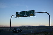
State Route 14 is a north–south state highway
in the U.S. state
of California
, largely in the Mojave Desert
. The southern portion of the highway is signed as the Antelope Valley Freeway. The route connects Interstate 5
, or Golden State Freeway, near Santa Clarita
and with U.S. Route 395
near Inyokern
. Legislatively, the route extends south of I-5 to State Route 1
in the Pacific Palisades area of Los Angeles
, however the portion south of the junction with I-5 has not been constructed. The southern part of the constructed route is a busy commuter freeway serving and connecting the communities of Santa Clarita
, Palmdale
and Lancaster
with the Greater Los Angeles
area. The northern portion, from Vincent (south of Palmdale) to Route 395, is legislatively named the Aerospace Highway, as the highway serves Edwards Air Force Base
, once one of the primary landing strips for NASA
's Space Shuttle
. This section is rural, following the line between the hot Mojave desert and the forming Sierra Nevada mountain range. Most of Route 14 is loosely paralleled by a main line of the Southern Pacific Railroad
, used for the Antelope Valley Line of the Metrolink
commuter rail system as well as a connection between Los Angeles and the California Central Valley
via Tehachapi Pass
.
Linked with US 395, this road connects Los Angeles with such places as Mammoth Mountain
, Mono Lake
, Yosemite National Park
and Reno, Nevada
. Route 14 was part of U.S. Route 6
prior to truncation in 1964, when U.S. 6 was a coast-to-coast route from Long Beach
to Provincetown, Massachusetts
. The non-freeway segment of SR 14 from Silver Queen Road north of Rosamond
to Mojave
is known as Sierra Highway
, as is the old routing between Interstate 5 and Silver Queen Road where SR 14 has been moved to a newer freeway alignment. Portions of Route 14 remain signed with names associated with US 6, including Midland Trail
, Theodore Roosevelt
Highway and Grand Army of the Republic Highway. This route is part of the California Freeway and Expressway System
.
, has been designated the Antelope Valley Freeway by the state legislature. The Antelope Valley Freeway begins in the Santa Susana Mountains
at the Newhall Pass interchange
by splitting from the Golden State Freeway (Interstate 5
). This is the busiest portion of the route with an annual average daily traffic
(AADT) count of 169,000 vehicles per day. The freeway forms the eastern boundary of Santa Clarita
along its route. Past Santa Clarita, the road continues to the northeast and crosses the Sierra Pelona Mountains
and western San Gabriel Mountains
via the canyon of the seasonal Santa Clara River
. The ascent is mostly rugged and rural terrain, with only two small towns along the ascent, first Agua Dulce
and later Acton
. Between the two towns the freeway forms the southern boundary of Vasquez Rocks Park, a county park. Just past Acton, the highway crests the San Gabriel mountains via Soledad Pass, at an elevation of 3225 feet (983 m). The route of the highway through the mountains loosely parallels that of the main line of the Southern Pacific Railroad
, which is also used for the Metrolink Antelope Valley Line
.
After cresting the pass, the highway descends into the Antelope Valley
, a large valley within the Mojave Desert
. The highway crosses Angeles Forest Highway
and the California Aqueduct
in the descent. Route 14 serves as the primary north–south thoroughfare for the communities of Palmdale
and Lancaster
. Between Palmdale Boulevard (County Route N2) and Avenue D in Lancaster, SR 14 runs concurrently
with SR 138
.
, SR 14 has been designated the Aerospace Highway. Between Pearblossom Highway and Avenue S, there is a vista point overlooking Lake Palmdale, which features an historic plaque that honors aviation accomplishments including the space shuttle, breaking the sound barrier and the speed record. The freeway passes the Los Angeles
/Kern County
line at Avenue A, and continues to run north through Rosamond
and Mojave
. In Rosamond, the highway passes close to Edwards Air Force Base
, which is used as one of the main landing strips for NASA
's Space Shuttle
, and as the base for the X-15 and many other air and spacecraft.
The freeway portion terminates just south of Mojave, where SR 14 serves as the main street and runs through the downtown area. To the east of the route is Mojave Air & Space Port, home to the National Test Pilot School
and SpaceShipOne, the first privately funded human spaceflight, as well as a vast airplane graveyard; all are visible from Route 14.
State Route 58
was formerly routed concurrent with SR 14 through Mojave, before it was rerouted onto a bypass running north and east of the town.
 The character of the highway changes as it leaves Mojave. The road, now a divided highway
with at-grade intersection
s, departs the corridor of the main Southern Pacific Line, to follow the crest of the forming Sierra Nevada mountains. The route continues to follow a branch line of the Southern Pacific used as a connector for the Trona Railway
. The main line of the railroad proceeds towards the Central Valley via Tehachapi Pass
. Though Route 14 heads away from the pass, the highway has views of the mountains and the Tehachapi Pass Wind Farm
. The scenery also changes, as the highway departs the Mojave Desert and crosses Red Rock Canyon State Park
. Traffic counts drop dramatically as the highway becomes more rural, with an AADT of 3200 vehicles at the northern terminus. SR 14 continues north toward U.S. Route 395
in Inyokern
, much of its routing as an expressway
. Towards its northern terminus, SR 14 runs briefly concurrent with State Route 178
. At its northern terminus, SR 14 merges with US 395 as it turns into an expressway heading north to Bishop
. As US 395 the route continues to follow the crest of the Sierra Nevada, serving Owens Valley
, Mammoth Mountain
, Yosemite National Park
and Mono Lake
.
 The first road to use the general alignment of modern Route 14 was called the El Camino Sierra, or Sierra Highway
, which extended from Los Angeles to Lake Tahoe
. A dirt road was completed in the 1910s from what had been a pack trail. The Los Angeles Times declared El Camino Sierra complete in 1931, when the portion from Mojave to the Owens Valley
, along modern US 395
, was paved.
During the late 19th century, the corridor of modern Route 14 was also in used by the Southern Pacific Railroad for two lines. The first is a line to connect Los Angeles with the Central Valley, via Tehachapi Pass. While significantly longer than the more direct Ridge Route
(modern Interstate 5), Tehachapi Pass is lower than Tejon Pass
along the Ridge Route, with a longer, less steep grade on the descent into the Central Valley. This rail line remains the primary rail line to connect southern and northern California in use today, now owned and operated by the Union Pacific Railroad
. The second resulted when the Southern Pacific acquired the un-finished Carson and Colorado Railroad
in 1900. The Southern Pacific built a standard gauge
connector to the narrow gauge
Carson and Colorado line from their main at Mojave. Although plans were to eventually convert this acquired line to standard gauge, most of the line was abandoned before the conversion was complete. However, the portion from Mojave to Route 14's terminus near Inyokern
is still active and used for connections to the Naval Air Weapons Station China Lake
and Trona Railway
.
The Midland Trail
was one of the first organized coast-to-coast trails in the United States. In the trail's infancy, its routing changed numerous times. By 1925, the Midland Trail was established along what is modern State Route 168
, joining El Camino Sierra in Big Pine
. Other named trails that would eventually follow this route included the Theodore Roosevelt
highway, and Grand Army of the Republic Highway. Parts of modern Route 14 continue to be signed with these names, and north of Los Angeles County is still officially designated "El Camino Sierra / Midland Trail" as well as the aforementioned "Aerospace Highway".
to Long Beach, California
on June 21, 1937. Most of this extension used the Midland Trail, although the route entered California from Nevada slightly north of the previous route of the Midland Trail, instead passing through Bishop
. While being designated US 6, parts of modern Route 14 began to be upgraded to freeway standards.
As part of the 1964 state highway renumbering
, US 6 was truncated at Bishop. The portion of US 6 from Inyokern
to Los Angeles was designated State Route 14. Previously the Route 14 designation was used for Artesia Boulevard and Lincoln Avenue, in the Los Angeles area, a portion of modern State Route 91
.
Between 1963 and 1975 significant portions of US 6/SR 14 were moved to a freeway alignment. The former routing south of Mojave (and the current routing to the north) is still known as Sierra Highway. The first freeway section, from just east of Solemint Junction to Red Rover Mine Road, was completed in 1963. Further portions in the intercanyon areas of Acton to Soledad Pass were completed by 1965. By 1966 the freeway was complete as far north as Avenue P-8 in Palmdale
. The freeway was completed to Mojave by 1972.
, where I-5, Sierra Highway
, Foothill Boulevard
, San Fernando Road
and the southern terminus of Route 14 meet, has been the site of a number of catastrophic incidents. The interchange has partially collapsed twice due to earthquakes; the 1971 Sylmar earthquake
and the 1994 Northridge earthquake. As a result of the 1994 collapse this intersection was renamed the "Clarence Wayne Dean Memorial Interchange", honoring a Los Angeles Police Department
motorcycle officer killed when he was unable to stop in time and drove off the collapsed flyover ramp from SR 14 south to I-5 south. After both earthquakes, the collapsed portions were rebuilt and surviving portions reinforced.
In 2007, two tractor-trailer trucks collided in a tunnel
along the truck lanes for southbound I-5 at the interchange. A resulting fire started, soon encompassing the entire tunnel along with 30 other trucks and one passenger vehicle that were in the tunnel at the time. The truck tunnel was closed for several days for structural damage inspections and repairs.
 Route 14 is an unfinished route, as the definition in the California Streets and Highways Code states that the route begins at State Route 1
(Pacific Coast Highway), near Sunset Blvd.
in the Pacific Palisades area of Los Angeles. Between the constructed end and legislative end of Route 14 is the area of Los Angeles called Reseda
and Topanga State Park
. There is no paved road that directly connects these two points, with State Route 27
or Interstate 405 being the nearest through roads in this area.
The intersection of Route 14 with Via Princessa in Santa Clarita is an unusual design, with long flyover ramps for the connections. This is the result of a freeway revolt by the residents of Santa Clarita, that canceled plans for a freeway extension of Route 126
. While the Via Princessa alignment of Route 126 was canceled, a different alignment is being constructed with proposed connections to Route 14.
growth in Santa Clarita, Lancaster, and Palmdale has made the Antelope Valley Freeway one of the most congested in southern California, with average rush hour
speeds well below 20 miles per hour (30 km/h). Future predictions call for continued growth along the Route 14 corridor, including predictions of a tripling of the population of Palmdale by 2030. In response, multiple government agencies have proposed adding more transportation arteries between Los Angeles and the Antelope Valley, as well expanding the capacity of the existing Route 14 and rail corridors.
Several proposals have been made to bypass the Antelope Valley Freeway by boring a tunnel underneath the San Gabriel Mountains and extending the Glendale Freeway through it to the Antelope Valley. In 2003, Caltrans published a map showing potential improvements to the transportation infrastructure of southern California. The proposal showed both the un-constructed portion of Route 14, as well as new routes over or under the mountains to Antelope Valley. In 2005, the idea was advanced as a combination toll tunnel and surface highway. Preliminary studies estimated costs around $3 billion and suggested charging a varying toll, adjusted for the time of day, averaging around $8 for one way passage.
{| class=wikitable
|-
!County
!Location
!Postmile
!Exit
!Destinations
!Notes
|-
|rowspan=33|Los Angeles
LA R24.79-R77.01
|rowspan=2|Los Angeles
|R24.79
|1
|
|Southbound exit and northbound entrance; signed as exits 1A (south) and 1B (north)
|-
|
|
|The Old Road
|Southbound exit and northbound entrance
|-
|rowspan=4|Santa Clarita
|R27.05
|2
|Newhall Avenue
|Former SR 126
west
|-
|R28.08
|3
|Placerita Canyon Road
|
|-
|R29.68
|5
|Golden Valley Road
|Connects to SR 126
to Ventura
|- style="background:#fdd;"
|R30.80
|6A
|Sierra Highway
– Canyon Country
|Northbound exit and southbound entrance; former US 6
|-
|
|R30.92
|6B
|Via Princessa
|Signed as exit 6 southbound
|-
|Santa Clarita
|33.42
|9
|Sand Canyon Road
|
|-
|
|35.71
|11
|Soledad Canyon Road
|
|-
|
|39.85
|15
|Agua Dulce Canyon Road
|
|-
|
|43.29
|19
|Escondido Canyon Road
|
|-
|
|46.76
|22
|Red Rover Mine Road, Sierra Highway
|Sierra Highway was former US 6
|-
|
|R48.61
|24
|Crown Valley Road – Acton
|
|-
|
|R50.75
|26
|Santiago Road
|
|-
|
|R52.17
|27
|Soledad Canyon Road
|
|-
|
|R54.54
|30
|Angeles Forest Highway
(CR N3), Pearblossom Highway
|
|-
|rowspan=6|Palmdale
|R58.17
|33
|Avenue S
|
|- style="background:#dfd;"
|R59.80
|35
|
|South end of SR 138 overlap
|- style="background:#fdd;"
|R61.37
|37
|Rancho Vista Boulevard (Avenue P)
|Northbound exit and southbound entrance; serves LA/Palmdale Regional Airport
|- style="background:#fdd;"
|R61.77
|37
|10th Street West
|Southbound exit and northbound entrance; serves LA/Palmdale Regional Airport
|-
|R63.67
|39
|Avenue N
|
|-
|rowspan=2|R64.68
|rowspan=2|40
|rowspan=2|Avenue M
|rowspan=2|Also known as Columbia Way
|-
|rowspan=8|Lancaster
|-
|R65.68
|41
|Avenue L
|
|-
|R66.73
|42
|Avenue K
|
|- style="background:#fdd;"
|R67.39
|43
|20th Street West
|Northbound exit and southbound entrance
|- style="background:#fdd;"
|R67.96
|43
|Avenue J (CR N5)
|Southbound exit and northbound entrance
|-
|R68.97
|44
|Avenue I
|
|-
|R69.99
|45
|Avenue H
|
|-
|R70.99
|46
|Avenue G
|
|-
|
|R72.00
|47
|Avenue F
|
|-
|
| style="background:#dfd;"|R74.00
| style="background:#dfd;"|49
| style="background:#dfd;"|
| style="background:#dfd;"|North end of SR 138 overlap
|-
|rowspan=2|
|rowspan=2|R77.01
|rowspan=2|52
|rowspan=2|Avenue A
|rowspan=2|
|-
|rowspan=14|Kern
KER R0.00-64.56
|-
|Rosamond
|R3.02
|55
|Rosamond Boulevard – Rosamond
, Edwards AFB
|
|-
|
|R6.12
|58
|Dawn Road
|
|-
|
|R9.15
|61
|Backus Road
|
|-
|
|R12.15
|64
|Silver Queen Road, Sierra Highway
|
|-
| style="text-align:center;" colspan="5"|North end of freeway
|-
|rowspan=2|Mojave
| style="background:#dfd;"|16.06
| style="background:#dfd;"|
| style="background:#dfd;"|, Las Vegas
| style="background:#dfd;"|South end of SR 58 Bus. overlap; former US 466 east / SR 58
east
|- style="background:#dfd;"
|L17.38
16.07
|
|
|North end of SR 58 Bus. overlap; former US 466 west / SR 58
west
|-
|
|19.24
|71
|
|Interchange
|-
|California City
|21.29
|73
|California City Boulevard, Randsburg Cutoff Road
|Interchange
|-
|
|35.56
|
|Redrock Randsburg Road – California City
, Randsburg
, Johannesburg
|
|-
|Freeman Junction
| style="background:#dfd;"|57.77
| style="background:#dfd;"|
| style="background:#dfd;"|
| style="background:#dfd;"|South end of SR 178 overlap
|-
|
| style="background:#dfd;"|60.57
| style="background:#dfd;"|
| style="background:#dfd;"|
| style="background:#dfd;"|North end of SR 178 overlap
|-
|
| style="background:#fdd;"|64.56
| style="background:#fdd;"|
| style="background:#fdd;"|, Reno
| style="background:#fdd;"|Interchange; northbound exit and southbound entrance; former US 6
north
State highway
State highway, state road or state route can refer to one of three related concepts, two of them related to a state or provincial government in a country that is divided into states or provinces :#A...
in the U.S. state
U.S. state
A U.S. state is any one of the 50 federated states of the United States of America that share sovereignty with the federal government. Because of this shared sovereignty, an American is a citizen both of the federal entity and of his or her state of domicile. Four states use the official title of...
of California
California
California is a state located on the West Coast of the United States. It is by far the most populous U.S. state, and the third-largest by land area...
, largely in the Mojave Desert
Mojave Desert
The Mojave Desert occupies a significant portion of southeastern California and smaller parts of central California, southern Nevada, southwestern Utah and northwestern Arizona, in the United States...
. The southern portion of the highway is signed as the Antelope Valley Freeway. The route connects Interstate 5
Interstate 5 in California
Interstate 5 is a major north–south route of the Interstate Highway System in the U.S. state of California. It begins at the Mexico – United States border at the San Ysidro crossing, goes north across the length of California and crosses into Oregon south of the Medford-Ashland metropolitan...
, or Golden State Freeway, near Santa Clarita
Santa Clarita, California
Santa Clarita is the fourth largest city in Los Angeles County, California, United States and the twenty-fourth largest city in the state of California. The 2010 US Census reported the city's population grew 16.7% from the year 2000 to 176,320 residents. It is located about northwest of downtown...
and with U.S. Route 395
U.S. Route 395 in California
In the U.S. state of California, U.S. Route 395 is a route which traverses from Interstate 15 near the southern city limits of Hesperia, north to the Oregon state line in Modoc County near Goose Lake...
near Inyokern
Inyokern, California
Inyokern is a census-designated place in Kern County, California, United States. Inyokern is located west of Ridgecrest, at an elevation of 2434 feet . Located in the Indian Wells Valley. The population was 1,099 at the 2010 census, up from 984 at the 2000 census...
. Legislatively, the route extends south of I-5 to State Route 1
California State Route 1
State Route 1 , more often called Highway 1, is a state highway that runs along much of the Pacific coast of the U.S. state of California. It is famous for running along some of the most beautiful coastlines in the world, leading to its designation as an All-American Road.Highway 1 does not run...
in the Pacific Palisades area of Los Angeles
Los Angeles, California
Los Angeles , with a population at the 2010 United States Census of 3,792,621, is the most populous city in California, USA and the second most populous in the United States, after New York City. It has an area of , and is located in Southern California...
, however the portion south of the junction with I-5 has not been constructed. The southern part of the constructed route is a busy commuter freeway serving and connecting the communities of Santa Clarita
Santa Clarita, California
Santa Clarita is the fourth largest city in Los Angeles County, California, United States and the twenty-fourth largest city in the state of California. The 2010 US Census reported the city's population grew 16.7% from the year 2000 to 176,320 residents. It is located about northwest of downtown...
, Palmdale
Palmdale, California
Palmdale is a city located in the center of northern Los Angeles County, California, United States.Palmdale was the first community within the Antelope Valley to incorporate as a city on August 24, 1962; 47 years later, voters approved creating a charter city in November, 2009. Palmdale is...
and Lancaster
Lancaster, California
Lancaster is a charter city in northern Los Angeles County, in the high desert, near the Kern County line. Lancaster currently ranks as the 30th largest city in California, and the 148th largest city in the United States. Lancaster is the principal city within the Antelope Valley...
with the Greater Los Angeles
Greater Los Angeles Area
The Greater Los Angeles Area, or the Southland, is a term used for the Combined Statistical Area sprawled over five counties in the southern part of California, namely Los Angeles County, Orange County, San Bernardino County, Riverside County and Ventura County...
area. The northern portion, from Vincent (south of Palmdale) to Route 395, is legislatively named the Aerospace Highway, as the highway serves Edwards Air Force Base
Edwards Air Force Base
Edwards Air Force Base is a United States Air Force base located on the border of Kern County, Los Angeles County, and San Bernardino County, California, in the Antelope Valley. It is southwest of the central business district of North Edwards, California and due east of Rosamond.It is named in...
, once one of the primary landing strips for NASA
NASA
The National Aeronautics and Space Administration is the agency of the United States government that is responsible for the nation's civilian space program and for aeronautics and aerospace research...
's Space Shuttle
Space Shuttle
The Space Shuttle was a manned orbital rocket and spacecraft system operated by NASA on 135 missions from 1981 to 2011. The system combined rocket launch, orbital spacecraft, and re-entry spaceplane with modular add-ons...
. This section is rural, following the line between the hot Mojave desert and the forming Sierra Nevada mountain range. Most of Route 14 is loosely paralleled by a main line of the Southern Pacific Railroad
Southern Pacific Railroad
The Southern Pacific Transportation Company , earlier Southern Pacific Railroad and Southern Pacific Company, and usually simply called the Southern Pacific or Espee, was an American railroad....
, used for the Antelope Valley Line of the Metrolink
Metrolink (Southern California)
Metrolink is a commuter rail system serving Los Angeles and the surrounding area of Southern California; it currently consists of six lines and 55 stations using of track....
commuter rail system as well as a connection between Los Angeles and the California Central Valley
California Central Valley
California's Central Valley is a large, flat valley that dominates the central portion of California. It is home to California's most productive agricultural efforts. The valley stretches approximately from northwest to southeast inland and parallel to the Pacific Ocean coast. Its northern half is...
via Tehachapi Pass
Tehachapi Pass
Tehachapi Pass is a mountain pass crossing the Tehachapi Mountains in Kern County, California in the United States. The route over the pass connects the San Joaquin Valley to the Mojave Desert...
.
Linked with US 395, this road connects Los Angeles with such places as Mammoth Mountain
Mammoth Mountain
Mammoth Mountain is a lava dome complex west of the town of Mammoth Lakes, California in the Inyo National Forest of Madera County and Mono County. It is home to a large ski area on the Mono County side....
, Mono Lake
Mono Lake
Mono Lake is a large, shallow saline lake in Mono County, California, formed at least 760,000 years ago as a terminal lake in a basin that has no outlet to the ocean...
, Yosemite National Park
Yosemite National Park
Yosemite National Park is a United States National Park spanning eastern portions of Tuolumne, Mariposa and Madera counties in east central California, United States. The park covers an area of and reaches across the western slopes of the Sierra Nevada mountain chain...
and Reno, Nevada
Reno, Nevada
Reno is the county seat of Washoe County, Nevada, United States. The city has a population of about 220,500 and is the most populous Nevada city outside of the Las Vegas metropolitan area...
. Route 14 was part of U.S. Route 6
U.S. Route 6 in California
U.S. Route 6, or US 6, is a transcontinental highway from the U.S. state of California to Massachusetts. In California, the highway lies in the eastern portion of the state from Bishop in the Owens Valley north to the Nevada state line in Esmeralda County...
prior to truncation in 1964, when U.S. 6 was a coast-to-coast route from Long Beach
Long Beach, California
Long Beach is a city situated in Los Angeles County in Southern California, on the Pacific coast of the United States. The city is the 36th-largest city in the nation and the seventh-largest in California. As of 2010, its population was 462,257...
to Provincetown, Massachusetts
Provincetown, Massachusetts
Provincetown is a New England town located at the extreme tip of Cape Cod in Barnstable County, Massachusetts, United States. The population was 3,431 at the 2000 census, with an estimated 2007 population of 3,174...
. The non-freeway segment of SR 14 from Silver Queen Road north of Rosamond
Rosamond, California
Rosamond is a census-designated place in Kern County, California, USA, north of Palmdale, in the Antelope Valley, the westernmost desert valley of the Mojave Desert. Rosamond is also south of Mojave, , and north of Lancaster at an elevation of 2342 feet...
to Mojave
Mojave, California
Mojave is a census-designated place in Kern County, California, United States. Mojave is located east of Bakersfield, at an elevation of 2762 feet...
is known as Sierra Highway
Sierra Highway
Sierra Highway or El Camino Sierra is a road in Southern California, United States. El Camino Sierra refers to the full length of a trail formed in the 19th century, rebuilt as highways in the early 20th century, that ran from Los Angeles to Lake Tahoe following parts of modern State Route 14, U.S....
, as is the old routing between Interstate 5 and Silver Queen Road where SR 14 has been moved to a newer freeway alignment. Portions of Route 14 remain signed with names associated with US 6, including Midland Trail
Midland Trail
For the trail's section in West Virginia see: The Midland Trail in West Virginia.The Midland Trail, also called the Roosevelt Midland Trail, was a national auto trail spanning the United States from Washington, D.C...
, Theodore Roosevelt
Theodore Roosevelt
Theodore "Teddy" Roosevelt was the 26th President of the United States . He is noted for his exuberant personality, range of interests and achievements, and his leadership of the Progressive Movement, as well as his "cowboy" persona and robust masculinity...
Highway and Grand Army of the Republic Highway. This route is part of the California Freeway and Expressway System
California Freeway and Expressway System
The California Freeway and Expressway System is a system of existing or planned freeways and expressways in the U.S. state of California. It is defined by the Streets and Highways Code.-List of roads in the system:*State Route 1 *State Route 2...
.
Antelope Valley Freeway
The southern portion of the freeway, from Interstate 5 to the Avenue D exit near LancasterLancaster, California
Lancaster is a charter city in northern Los Angeles County, in the high desert, near the Kern County line. Lancaster currently ranks as the 30th largest city in California, and the 148th largest city in the United States. Lancaster is the principal city within the Antelope Valley...
, has been designated the Antelope Valley Freeway by the state legislature. The Antelope Valley Freeway begins in the Santa Susana Mountains
Santa Susana Mountains
The Santa Susana Mountains are a transverse range of mountains in southern California, north of the city of Los Angeles, in the United States. The range runs east-west separating the San Fernando Valley and Simi Valley on its south, from Santa Clara River Valley to the north, and Santa Clarita...
at the Newhall Pass interchange
Newhall Pass interchange
The Newhall Pass Interchange is a highway interchange at Newhall Pass, north of Sylmar in Southern California, United States. It connects Interstate 5 with State Route 14 , and includes truck bypass roadways...
by splitting from the Golden State Freeway (Interstate 5
Interstate 5 in California
Interstate 5 is a major north–south route of the Interstate Highway System in the U.S. state of California. It begins at the Mexico – United States border at the San Ysidro crossing, goes north across the length of California and crosses into Oregon south of the Medford-Ashland metropolitan...
). This is the busiest portion of the route with an annual average daily traffic
Annual average daily traffic
Average Annual daily traffic, abbreviated AADT, is a measure used primarily in transportation planning and transportation engineering. It is the total volume of vehicle traffic of a highway or road for a year divided by 365 days. AADT is a useful and simple measurement of how busy the road is...
(AADT) count of 169,000 vehicles per day. The freeway forms the eastern boundary of Santa Clarita
Santa Clarita, California
Santa Clarita is the fourth largest city in Los Angeles County, California, United States and the twenty-fourth largest city in the state of California. The 2010 US Census reported the city's population grew 16.7% from the year 2000 to 176,320 residents. It is located about northwest of downtown...
along its route. Past Santa Clarita, the road continues to the northeast and crosses the Sierra Pelona Mountains
Sierra Pelona Mountains
The Sierra Pelona Mountains , or the Sierra Pelona Ridge, is a mountain range in the Transverse Ranges of Southern California.. They are located within Los Angeles and Kern Counties.-Geography:...
and western San Gabriel Mountains
San Gabriel Mountains
The San Gabriel Mountains Range is located in northern Los Angeles County and western San Bernardino County, California, United States. The mountain range lies between the Los Angeles Basin and the Mojave Desert, with Interstate 5 to the west and Interstate 15 to the east...
via the canyon of the seasonal Santa Clara River
Santa Clara River (California)
The Santa Clara River is approximately long, located in southern California in the United States. It drains an area of the coastal mountains north of Los Angeles. The Santa Clara is one of the largest river systems along the coast of Southern California and one of only a few remaining river...
. The ascent is mostly rugged and rural terrain, with only two small towns along the ascent, first Agua Dulce
Agua Dulce, California
Agua Dulce is a census-designated place located in Los Angeles County, California. It lies at an elevation of 2,526 feet . Agua Dulce is located just north of Santa Clarita. The town has a population of about 4,000. It is located at and covers a geographic area of about...
and later Acton
Acton, California
Acton was founded in 1887 by gold miners who were working in the Red Rover Mine. It was named after Acton, Massachusetts by one of the miners. Two of the best-known gold mines located in Acton were the Red Rover mine and the Governors mine. Mining of gold, copper, and titanium ore continued into...
. Between the two towns the freeway forms the southern boundary of Vasquez Rocks Park, a county park. Just past Acton, the highway crests the San Gabriel mountains via Soledad Pass, at an elevation of 3225 feet (983 m). The route of the highway through the mountains loosely parallels that of the main line of the Southern Pacific Railroad
Southern Pacific Railroad
The Southern Pacific Transportation Company , earlier Southern Pacific Railroad and Southern Pacific Company, and usually simply called the Southern Pacific or Espee, was an American railroad....
, which is also used for the Metrolink Antelope Valley Line
Metrolink Antelope Valley Line
The Antelope Valley Line is a commuter rail line that serves the Northern Los Angeles County area as part of the Metrolink system. The line is presently more rural in character because it travels through the sparsely populated Soledad Canyon between Santa Clarita and Palmdale, serving the small...
.
After cresting the pass, the highway descends into the Antelope Valley
Antelope Valley
The Antelope Valley in California, United States, is located in northern Los Angeles County and the southeastern portion of Kern County, California, and constitutes the western tip of the Mojave Desert...
, a large valley within the Mojave Desert
Mojave Desert
The Mojave Desert occupies a significant portion of southeastern California and smaller parts of central California, southern Nevada, southwestern Utah and northwestern Arizona, in the United States...
. The highway crosses Angeles Forest Highway
Angeles Forest Highway
The Angeles Forest Highway traverses the Angeles National Forest and connects the Los Angeles basin to the Antelope Valley by going up and over the San Gabriel Mountains. The highway is variously known as County Road N-3 or FH-59 or the Palmdale cutoff. It is about long...
and the California Aqueduct
California Aqueduct
The Governor Edmund G. Brown California Aqueduct is a system of canals, tunnels, and pipelines that conveys water collected from the Sierra Nevada Mountains and valleys of Northern- and Central California to Southern California. The Department of Water Resources operates and maintains the...
in the descent. Route 14 serves as the primary north–south thoroughfare for the communities of Palmdale
Palmdale, California
Palmdale is a city located in the center of northern Los Angeles County, California, United States.Palmdale was the first community within the Antelope Valley to incorporate as a city on August 24, 1962; 47 years later, voters approved creating a charter city in November, 2009. Palmdale is...
and Lancaster
Lancaster, California
Lancaster is a charter city in northern Los Angeles County, in the high desert, near the Kern County line. Lancaster currently ranks as the 30th largest city in California, and the 148th largest city in the United States. Lancaster is the principal city within the Antelope Valley...
. Between Palmdale Boulevard (County Route N2) and Avenue D in Lancaster, SR 14 runs concurrently
Concurrency (road)
A concurrency, overlap, or coincidence in a road network is an instance of one physical road bearing two or more different highway, motorway, or other route numbers...
with SR 138
California State Route 138
State Route 138 is an east–west state highway generally following the northern foothills of the San Gabriel Mountains of southern California, USA from its junction with Interstate 5 south of Gorman eastward to Mount Anderson Junction, its eastern junction with State Route 18 south of...
.
Aerospace Highway
From the Pearblossom Highway exit south of Palmdale to its northern terminus at Route 395 near InyokernInyokern, California
Inyokern is a census-designated place in Kern County, California, United States. Inyokern is located west of Ridgecrest, at an elevation of 2434 feet . Located in the Indian Wells Valley. The population was 1,099 at the 2010 census, up from 984 at the 2000 census...
, SR 14 has been designated the Aerospace Highway. Between Pearblossom Highway and Avenue S, there is a vista point overlooking Lake Palmdale, which features an historic plaque that honors aviation accomplishments including the space shuttle, breaking the sound barrier and the speed record. The freeway passes the Los Angeles
Los Angeles County, California
Los Angeles County is a county in the U.S. state of California. As of 2010 U.S. Census, the county had a population of 9,818,605, making it the most populous county in the United States. Los Angeles County alone is more populous than 42 individual U.S. states...
/Kern County
Kern County, California
Spreading across the southern end of the California Central Valley, Kern County is the fifth-largest county by population in California. Its economy is heavily linked to agriculture and to petroleum extraction, and there is a strong aviation and space presence. Politically, it has generally...
line at Avenue A, and continues to run north through Rosamond
Rosamond, California
Rosamond is a census-designated place in Kern County, California, USA, north of Palmdale, in the Antelope Valley, the westernmost desert valley of the Mojave Desert. Rosamond is also south of Mojave, , and north of Lancaster at an elevation of 2342 feet...
and Mojave
Mojave, California
Mojave is a census-designated place in Kern County, California, United States. Mojave is located east of Bakersfield, at an elevation of 2762 feet...
. In Rosamond, the highway passes close to Edwards Air Force Base
Edwards Air Force Base
Edwards Air Force Base is a United States Air Force base located on the border of Kern County, Los Angeles County, and San Bernardino County, California, in the Antelope Valley. It is southwest of the central business district of North Edwards, California and due east of Rosamond.It is named in...
, which is used as one of the main landing strips for NASA
NASA
The National Aeronautics and Space Administration is the agency of the United States government that is responsible for the nation's civilian space program and for aeronautics and aerospace research...
's Space Shuttle
Space Shuttle
The Space Shuttle was a manned orbital rocket and spacecraft system operated by NASA on 135 missions from 1981 to 2011. The system combined rocket launch, orbital spacecraft, and re-entry spaceplane with modular add-ons...
, and as the base for the X-15 and many other air and spacecraft.
The freeway portion terminates just south of Mojave, where SR 14 serves as the main street and runs through the downtown area. To the east of the route is Mojave Air & Space Port, home to the National Test Pilot School
National Test Pilot School
The National Test Pilot School is a civilian test pilot school located at the Mojave Air & Space Port in Mojave, California. The school attracts students primarily from commercial aircraft manufacturers and military air forces...
and SpaceShipOne, the first privately funded human spaceflight, as well as a vast airplane graveyard; all are visible from Route 14.
State Route 58
California State Route 58
State Route 58 is an east-west highway across the California Coast Ranges, the southern San Joaquin Valley, the Tehachapi Mountains, which border the southern Sierra Nevada, and the Mojave Desert. It runs between its western terminus near Santa Margarita and its eastern terminus at Barstow...
was formerly routed concurrent with SR 14 through Mojave, before it was rerouted onto a bypass running north and east of the town.
Divided Highway
Divided Highway is a compilation album by American rock band The Doobie Brothers, released in 2003. . All tracks are taken from the albums Cycles and Brotherhood .-Track listing:...
with at-grade intersection
At-grade intersection
An at-grade intersection is a junction at which two or more transport axes cross at the same level .-Traffic management:With areas of high or fast traffic, an at-grade intersection normally requires a traffic control device such as a stop sign, traffic light or railway signal to manage conflicting...
s, departs the corridor of the main Southern Pacific Line, to follow the crest of the forming Sierra Nevada mountains. The route continues to follow a branch line of the Southern Pacific used as a connector for the Trona Railway
Trona Railway
The Trona Railway is a shortline railroad owned by Searles Valley Minerals.The TRC interchanges with the Union Pacific Railroad at Searles, California....
. The main line of the railroad proceeds towards the Central Valley via Tehachapi Pass
Tehachapi Pass
Tehachapi Pass is a mountain pass crossing the Tehachapi Mountains in Kern County, California in the United States. The route over the pass connects the San Joaquin Valley to the Mojave Desert...
. Though Route 14 heads away from the pass, the highway has views of the mountains and the Tehachapi Pass Wind Farm
Tehachapi Pass Wind Farm
Wind development in the Tehachapi Pass began in the early 1980s. The area hosts a multitude of wind farms, comprising one of California's largest wind resource areas. The pass is undergoing much repowering activity...
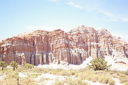
. The scenery also changes, as the highway departs the Mojave Desert and crosses Red Rock Canyon State Park
Red Rock Canyon State Park (California)
Red Rock Canyon State Park features scenic desert cliffs, buttes and spectacular rock formations. The park is located where the southernmost tip of the Sierra Nevada converges with the El Paso Mountains....
. Traffic counts drop dramatically as the highway becomes more rural, with an AADT of 3200 vehicles at the northern terminus. SR 14 continues north toward U.S. Route 395
U.S. Route 395 in California
In the U.S. state of California, U.S. Route 395 is a route which traverses from Interstate 15 near the southern city limits of Hesperia, north to the Oregon state line in Modoc County near Goose Lake...
in Inyokern
Inyokern, California
Inyokern is a census-designated place in Kern County, California, United States. Inyokern is located west of Ridgecrest, at an elevation of 2434 feet . Located in the Indian Wells Valley. The population was 1,099 at the 2010 census, up from 984 at the 2000 census...
, much of its routing as an expressway
Limited-access road
A limited-access road known by various terms worldwide, including limited-access highway, dual-carriageway and expressway, is a highway or arterial road for high-speed traffic which has many or most characteristics of a controlled-access highway , including limited or no access to adjacent...
. Towards its northern terminus, SR 14 runs briefly concurrent with State Route 178
California State Route 178
State Route 178 is a route that exists in two constructed segments. The gap in between segments is connected by various local roads and State Route 190 through Death Valley National Park....
. At its northern terminus, SR 14 merges with US 395 as it turns into an expressway heading north to Bishop
Bishop, California
Bishop is a city in Inyo County, California, United States. Though Bishop is the only city and the largest populated place in Inyo County, the county seat is Independence. Bishop is located near the northern end of the Owens Valley, at an elevation of 4147 feet . The population was 3,879 at the...
. As US 395 the route continues to follow the crest of the Sierra Nevada, serving Owens Valley
Owens Valley
Owens Valley is the arid valley of the Owens River in eastern California in the United States, to the east of the Sierra Nevada and west of the White Mountains and Inyo Mountains on the west edge of the Great Basin section...
, Mammoth Mountain
Mammoth Mountain
Mammoth Mountain is a lava dome complex west of the town of Mammoth Lakes, California in the Inyo National Forest of Madera County and Mono County. It is home to a large ski area on the Mono County side....
, Yosemite National Park
Yosemite National Park
Yosemite National Park is a United States National Park spanning eastern portions of Tuolumne, Mariposa and Madera counties in east central California, United States. The park covers an area of and reaches across the western slopes of the Sierra Nevada mountain chain...
and Mono Lake
Mono Lake
Mono Lake is a large, shallow saline lake in Mono County, California, formed at least 760,000 years ago as a terminal lake in a basin that has no outlet to the ocean...
.
Trails
Sierra Highway
Sierra Highway or El Camino Sierra is a road in Southern California, United States. El Camino Sierra refers to the full length of a trail formed in the 19th century, rebuilt as highways in the early 20th century, that ran from Los Angeles to Lake Tahoe following parts of modern State Route 14, U.S....
, which extended from Los Angeles to Lake Tahoe
Lake Tahoe
Lake Tahoe is a large freshwater lake in the Sierra Nevada of the United States. At a surface elevation of , it is located along the border between California and Nevada, west of Carson City. Lake Tahoe is the largest alpine lake in North America. Its depth is , making it the USA's second-deepest...
. A dirt road was completed in the 1910s from what had been a pack trail. The Los Angeles Times declared El Camino Sierra complete in 1931, when the portion from Mojave to the Owens Valley
Owens Valley
Owens Valley is the arid valley of the Owens River in eastern California in the United States, to the east of the Sierra Nevada and west of the White Mountains and Inyo Mountains on the west edge of the Great Basin section...
, along modern US 395
U.S. Route 395 in California
In the U.S. state of California, U.S. Route 395 is a route which traverses from Interstate 15 near the southern city limits of Hesperia, north to the Oregon state line in Modoc County near Goose Lake...
, was paved.
During the late 19th century, the corridor of modern Route 14 was also in used by the Southern Pacific Railroad for two lines. The first is a line to connect Los Angeles with the Central Valley, via Tehachapi Pass. While significantly longer than the more direct Ridge Route
Ridge Route
The Ridge Route, officially the Castaic-Tejon Route, was a two-lane highway running between Los Angeles and Kern counties, California. Opened in 1915 and paved with concrete between 1917 and 1921, the road was the first paved highway directly linking the Los Angeles Basin with the San Joaquin...
(modern Interstate 5), Tehachapi Pass is lower than Tejon Pass
Tejon Pass
The Tejon Pass is a mountain pass at the southwest end of the Tehachapi Mountains linking Southern to Central California.-Geography:The apex of the pass is near the northwesternmost corner of Los Angeles County, north of Gorman...
along the Ridge Route, with a longer, less steep grade on the descent into the Central Valley. This rail line remains the primary rail line to connect southern and northern California in use today, now owned and operated by the Union Pacific Railroad
Union Pacific Railroad
The Union Pacific Railroad , headquartered in Omaha, Nebraska, is the largest railroad network in the United States. James R. Young is president, CEO and Chairman....
. The second resulted when the Southern Pacific acquired the un-finished Carson and Colorado Railroad
Carson and Colorado Railroad
The Carson and Colorado Railway was a U.S. narrow gauge railroad that ran from Mound House, Nevada, to Keeler, California below the Cerro Gordo Mines. It was incorporated on May 10, 1880 as the Carson and Colorado Railroad, and construction on the railroad began on May 31, 1880. A track gauge of ...
in 1900. The Southern Pacific built a standard gauge
Standard gauge
The standard gauge is a widely-used track gauge . Approximately 60% of the world's existing railway lines are built to this gauge...
connector to the narrow gauge
Narrow gauge
A narrow gauge railway is a railway that has a track gauge narrower than the of standard gauge railways. Most existing narrow gauge railways have gauges of between and .- Overview :...
Carson and Colorado line from their main at Mojave. Although plans were to eventually convert this acquired line to standard gauge, most of the line was abandoned before the conversion was complete. However, the portion from Mojave to Route 14's terminus near Inyokern
Inyokern, California
Inyokern is a census-designated place in Kern County, California, United States. Inyokern is located west of Ridgecrest, at an elevation of 2434 feet . Located in the Indian Wells Valley. The population was 1,099 at the 2010 census, up from 984 at the 2000 census...
is still active and used for connections to the Naval Air Weapons Station China Lake
Naval Air Weapons Station China Lake
- About : is part of under Commander, Navy Installation Command and is located in the Western Mojave Desert region of California, approximately north of Los Angeles. Occupying three counties – Kern, San Bernardino and Inyo – the installation’s closest neighbors are the cities of Ridgecrest,...
and Trona Railway
Trona Railway
The Trona Railway is a shortline railroad owned by Searles Valley Minerals.The TRC interchanges with the Union Pacific Railroad at Searles, California....
.
The Midland Trail
Midland Trail
For the trail's section in West Virginia see: The Midland Trail in West Virginia.The Midland Trail, also called the Roosevelt Midland Trail, was a national auto trail spanning the United States from Washington, D.C...
was one of the first organized coast-to-coast trails in the United States. In the trail's infancy, its routing changed numerous times. By 1925, the Midland Trail was established along what is modern State Route 168
California State Route 168
State Route 168 is a state highway in California, USA, which is separated into three distinct segments, in part by the Sierra Nevada mountains....
, joining El Camino Sierra in Big Pine
Big Pine, California
Big Pine is a census-designated place in Inyo County, California, United States. Big Pine is located south-southeast of Bishop, at an elevation of 3990 feet . The population was 1,756 at the 2010 census, up from 1,350 at the 2000 census...
. Other named trails that would eventually follow this route included the Theodore Roosevelt
Theodore Roosevelt
Theodore "Teddy" Roosevelt was the 26th President of the United States . He is noted for his exuberant personality, range of interests and achievements, and his leadership of the Progressive Movement, as well as his "cowboy" persona and robust masculinity...
highway, and Grand Army of the Republic Highway. Parts of modern Route 14 continue to be signed with these names, and north of Los Angeles County is still officially designated "El Camino Sierra / Midland Trail" as well as the aforementioned "Aerospace Highway".
U.S. Route 6
U.S. Route 6 was extended from Greeley, ColoradoGreeley, Colorado
The City of Greeley is a Home Rule Municipality that is the county seat and the most populous city of Weld County, Colorado, United States. Greeley is located in the region known as Northern Colorado. Greeley is situated north-northeast of the Colorado State Capitol in Denver. According to the...
to Long Beach, California
Long Beach, California
Long Beach is a city situated in Los Angeles County in Southern California, on the Pacific coast of the United States. The city is the 36th-largest city in the nation and the seventh-largest in California. As of 2010, its population was 462,257...
on June 21, 1937. Most of this extension used the Midland Trail, although the route entered California from Nevada slightly north of the previous route of the Midland Trail, instead passing through Bishop
Bishop, California
Bishop is a city in Inyo County, California, United States. Though Bishop is the only city and the largest populated place in Inyo County, the county seat is Independence. Bishop is located near the northern end of the Owens Valley, at an elevation of 4147 feet . The population was 3,879 at the...
. While being designated US 6, parts of modern Route 14 began to be upgraded to freeway standards.
As part of the 1964 state highway renumbering
1964 state highway renumbering (California)
In 1963 and 1964, the California Division of Highways implemented a major renumbering of its state highways. The majority of sign routes — those marked for the public — kept their numbers; the main changes were to the legislative routes, which had their numbers changed to match the sign routes...
, US 6 was truncated at Bishop. The portion of US 6 from Inyokern
Inyokern, California
Inyokern is a census-designated place in Kern County, California, United States. Inyokern is located west of Ridgecrest, at an elevation of 2434 feet . Located in the Indian Wells Valley. The population was 1,099 at the 2010 census, up from 984 at the 2000 census...
to Los Angeles was designated State Route 14. Previously the Route 14 designation was used for Artesia Boulevard and Lincoln Avenue, in the Los Angeles area, a portion of modern State Route 91
California State Route 91
State Route 91 is a major east–west freeway located entirely within Southern California and serving several regions of the Greater Los Angeles metropolitan area...
.
Between 1963 and 1975 significant portions of US 6/SR 14 were moved to a freeway alignment. The former routing south of Mojave (and the current routing to the north) is still known as Sierra Highway. The first freeway section, from just east of Solemint Junction to Red Rover Mine Road, was completed in 1963. Further portions in the intercanyon areas of Acton to Soledad Pass were completed by 1965. By 1966 the freeway was complete as far north as Avenue P-8 in Palmdale
Palmdale, California
Palmdale is a city located in the center of northern Los Angeles County, California, United States.Palmdale was the first community within the Antelope Valley to incorporate as a city on August 24, 1962; 47 years later, voters approved creating a charter city in November, 2009. Palmdale is...
. The freeway was completed to Mojave by 1972.
Incidents
The Newhall Pass interchangeNewhall Pass interchange
The Newhall Pass Interchange is a highway interchange at Newhall Pass, north of Sylmar in Southern California, United States. It connects Interstate 5 with State Route 14 , and includes truck bypass roadways...
, where I-5, Sierra Highway
Sierra Highway
Sierra Highway or El Camino Sierra is a road in Southern California, United States. El Camino Sierra refers to the full length of a trail formed in the 19th century, rebuilt as highways in the early 20th century, that ran from Los Angeles to Lake Tahoe following parts of modern State Route 14, U.S....
, Foothill Boulevard
Foothill Boulevard (Southern California)
Foothill Boulevard is a major road in the city and county of Los Angeles, as well as an arterial road in the city and county of San Bernardino, stretching well over 60 miles in length, with some notable breaks along the route...
, San Fernando Road
San Fernando Road
San Fernando Road is a major street in the city and county of Los Angeles. It starts off in Castaic as The Old Road, passing through Santa Clarita and the Newhall Pass, whereupon its intersection with Sierra Highway near the junction of the Golden State and the Antelope Valley Freeways, it...
and the southern terminus of Route 14 meet, has been the site of a number of catastrophic incidents. The interchange has partially collapsed twice due to earthquakes; the 1971 Sylmar earthquake
Sylmar earthquake
The 1971 San Fernando earthquake struck the San Fernando Valley near Sylmar, California at 6:00:55 a.m. PST on February 9, 1971, with a magnitude of 6.6....
and the 1994 Northridge earthquake. As a result of the 1994 collapse this intersection was renamed the "Clarence Wayne Dean Memorial Interchange", honoring a Los Angeles Police Department
Los Angeles Police Department
The Los Angeles Police Department is the police department of the city of Los Angeles, California. With just under 10,000 officers and more than 3,000 civilian staff, covering an area of with a population of more than 4.1 million people, it is the third largest local law enforcement agency in...
motorcycle officer killed when he was unable to stop in time and drove off the collapsed flyover ramp from SR 14 south to I-5 south. After both earthquakes, the collapsed portions were rebuilt and surviving portions reinforced.
In 2007, two tractor-trailer trucks collided in a tunnel
Tunnel
A tunnel is an underground passageway, completely enclosed except for openings for egress, commonly at each end.A tunnel may be for foot or vehicular road traffic, for rail traffic, or for a canal. Some tunnels are aqueducts to supply water for consumption or for hydroelectric stations or are sewers...
along the truck lanes for southbound I-5 at the interchange. A resulting fire started, soon encompassing the entire tunnel along with 30 other trucks and one passenger vehicle that were in the tunnel at the time. The truck tunnel was closed for several days for structural damage inspections and repairs.
Cancelled plans
California State Route 1
State Route 1 , more often called Highway 1, is a state highway that runs along much of the Pacific coast of the U.S. state of California. It is famous for running along some of the most beautiful coastlines in the world, leading to its designation as an All-American Road.Highway 1 does not run...
(Pacific Coast Highway), near Sunset Blvd.
Sunset Boulevard
Sunset Boulevard is a street in the western part of Los Angeles County, California, that stretches from Figueroa Street in downtown Los Angeles to the Pacific Coast Highway at the Pacific Ocean in the Pacific Palisades...
in the Pacific Palisades area of Los Angeles. Between the constructed end and legislative end of Route 14 is the area of Los Angeles called Reseda
Reseda, Los Angeles, California
Reseda is a San Fernando Valley district in the city of Los Angeles, California.-History:The area now known as Reseda was originally inhabited by Native Americans of the Tongva tribe that lived close to the Los Angeles River....
and Topanga State Park
Topanga State Park
Topanga State Park is a California state park located in Los Angeles County. It is located adjacent to the unincorporated community of Topanga, California, within the city of Los Angeles, California...
. There is no paved road that directly connects these two points, with State Route 27
California State Route 27
State Route 27 is a state highway in the U.S. state of California that runs from Pacific Coast Highway at Topanga State Beach near Pacific Palisades, through Topanga Canyon including the community of Fernwood Pacific also known as Topanga, and continuing through Woodland Hills, Canoga Park, West...
or Interstate 405 being the nearest through roads in this area.
The intersection of Route 14 with Via Princessa in Santa Clarita is an unusual design, with long flyover ramps for the connections. This is the result of a freeway revolt by the residents of Santa Clarita, that canceled plans for a freeway extension of Route 126
California State Route 126
State Route 126 is a highway in Ventura and Los Angeles counties, California. The route runs from U.S. Route 101 in Ventura to Interstate 5 in Santa Clarita...
. While the Via Princessa alignment of Route 126 was canceled, a different alignment is being constructed with proposed connections to Route 14.
Future plans
Rapid exurbanCommuter town
A commuter town is an urban community that is primarily residential, from which most of the workforce commutes out to earn their livelihood. Many commuter towns act as suburbs of a nearby metropolis that workers travel to daily, and many suburbs are commuter towns...
growth in Santa Clarita, Lancaster, and Palmdale has made the Antelope Valley Freeway one of the most congested in southern California, with average rush hour
Rush hour
A rush hour or peak hour is a part of the day during which traffic congestion on roads and crowding on public transport is at its highest. Normally, this happens twice a day—once in the morning and once in the evening, the times during when the most people commute...
speeds well below 20 miles per hour (30 km/h). Future predictions call for continued growth along the Route 14 corridor, including predictions of a tripling of the population of Palmdale by 2030. In response, multiple government agencies have proposed adding more transportation arteries between Los Angeles and the Antelope Valley, as well expanding the capacity of the existing Route 14 and rail corridors.
Several proposals have been made to bypass the Antelope Valley Freeway by boring a tunnel underneath the San Gabriel Mountains and extending the Glendale Freeway through it to the Antelope Valley. In 2003, Caltrans published a map showing potential improvements to the transportation infrastructure of southern California. The proposal showed both the un-constructed portion of Route 14, as well as new routes over or under the mountains to Antelope Valley. In 2005, the idea was advanced as a combination toll tunnel and surface highway. Preliminary studies estimated costs around $3 billion and suggested charging a varying toll, adjusted for the time of day, averaging around $8 for one way passage.
Major intersections
- Note: Except where prefixed with a letter, postmiles were measured in 1964, based on the alignment as it existed at that time, and do not necessarily reflect current mileage. The numbers reset at county lines; the start and end postmiles in each county are given in the county column.
{| class=wikitable
|-
!County
!Location
!Postmile
!Exit
!Destinations
!Notes
|-
|rowspan=33|Los Angeles
Los Angeles County, California
Los Angeles County is a county in the U.S. state of California. As of 2010 U.S. Census, the county had a population of 9,818,605, making it the most populous county in the United States. Los Angeles County alone is more populous than 42 individual U.S. states...
LA R24.79-R77.01
|rowspan=2|Los Angeles
Los Angeles, California
Los Angeles , with a population at the 2010 United States Census of 3,792,621, is the most populous city in California, USA and the second most populous in the United States, after New York City. It has an area of , and is located in Southern California...
|R24.79
|1
|
|Southbound exit and northbound entrance; signed as exits 1A (south) and 1B (north)
|-
|
|
|The Old Road
|Southbound exit and northbound entrance
|-
|rowspan=4|Santa Clarita
Santa Clarita, California
Santa Clarita is the fourth largest city in Los Angeles County, California, United States and the twenty-fourth largest city in the state of California. The 2010 US Census reported the city's population grew 16.7% from the year 2000 to 176,320 residents. It is located about northwest of downtown...
|R27.05
|2
|Newhall Avenue
|Former SR 126
California State Route 126
State Route 126 is a highway in Ventura and Los Angeles counties, California. The route runs from U.S. Route 101 in Ventura to Interstate 5 in Santa Clarita...
west
|-
|R28.08
|3
|Placerita Canyon Road
|
|-
|R29.68
|5
|Golden Valley Road
|Connects to SR 126
California State Route 126
State Route 126 is a highway in Ventura and Los Angeles counties, California. The route runs from U.S. Route 101 in Ventura to Interstate 5 in Santa Clarita...
to Ventura
|- style="background:#fdd;"
|R30.80
|6A
|Sierra Highway
Sierra Highway
Sierra Highway or El Camino Sierra is a road in Southern California, United States. El Camino Sierra refers to the full length of a trail formed in the 19th century, rebuilt as highways in the early 20th century, that ran from Los Angeles to Lake Tahoe following parts of modern State Route 14, U.S....
– Canyon Country
Canyon Country, Santa Clarita, California
Canyon Country is a community and district within the town of Santa Clarita, located in northwestern Los Angeles County, California, United States....
|Northbound exit and southbound entrance; former US 6
U.S. Route 6 in California
U.S. Route 6, or US 6, is a transcontinental highway from the U.S. state of California to Massachusetts. In California, the highway lies in the eastern portion of the state from Bishop in the Owens Valley north to the Nevada state line in Esmeralda County...
|-
|
|R30.92
|6B
|Via Princessa
|Signed as exit 6 southbound
|-
|Santa Clarita
Santa Clarita, California
Santa Clarita is the fourth largest city in Los Angeles County, California, United States and the twenty-fourth largest city in the state of California. The 2010 US Census reported the city's population grew 16.7% from the year 2000 to 176,320 residents. It is located about northwest of downtown...
|33.42
|9
|Sand Canyon Road
|
|-
|
|35.71
|11
|Soledad Canyon Road
|
|-
|
|39.85
|15
|Agua Dulce Canyon Road
|
|-
|
|43.29
|19
|Escondido Canyon Road
|
|-
|
|46.76
|22
|Red Rover Mine Road, Sierra Highway
Sierra Highway
Sierra Highway or El Camino Sierra is a road in Southern California, United States. El Camino Sierra refers to the full length of a trail formed in the 19th century, rebuilt as highways in the early 20th century, that ran from Los Angeles to Lake Tahoe following parts of modern State Route 14, U.S....
|Sierra Highway was former US 6
U.S. Route 6 in California
U.S. Route 6, or US 6, is a transcontinental highway from the U.S. state of California to Massachusetts. In California, the highway lies in the eastern portion of the state from Bishop in the Owens Valley north to the Nevada state line in Esmeralda County...
|-
|
|R48.61
|24
|Crown Valley Road – Acton
Acton, California
Acton was founded in 1887 by gold miners who were working in the Red Rover Mine. It was named after Acton, Massachusetts by one of the miners. Two of the best-known gold mines located in Acton were the Red Rover mine and the Governors mine. Mining of gold, copper, and titanium ore continued into...
|
|-
|
|R50.75
|26
|Santiago Road
|
|-
|
|R52.17
|27
|Soledad Canyon Road
|
|-
|
|R54.54
|30
|Angeles Forest Highway
Angeles Forest Highway
The Angeles Forest Highway traverses the Angeles National Forest and connects the Los Angeles basin to the Antelope Valley by going up and over the San Gabriel Mountains. The highway is variously known as County Road N-3 or FH-59 or the Palmdale cutoff. It is about long...
(CR N3), Pearblossom Highway
|
|-
|rowspan=6|Palmdale
Palmdale, California
Palmdale is a city located in the center of northern Los Angeles County, California, United States.Palmdale was the first community within the Antelope Valley to incorporate as a city on August 24, 1962; 47 years later, voters approved creating a charter city in November, 2009. Palmdale is...
|R58.17
|33
|Avenue S
|
|- style="background:#dfd;"
|R59.80
|35
|
|South end of SR 138 overlap
|- style="background:#fdd;"
|R61.37
|37
|Rancho Vista Boulevard (Avenue P)
|Northbound exit and southbound entrance; serves LA/Palmdale Regional Airport
|- style="background:#fdd;"
|R61.77
|37
|10th Street West
|Southbound exit and northbound entrance; serves LA/Palmdale Regional Airport
|-
|R63.67
|39
|Avenue N
|
|-
|rowspan=2|R64.68
|rowspan=2|40
|rowspan=2|Avenue M
|rowspan=2|Also known as Columbia Way
|-
|rowspan=8|Lancaster
Lancaster, California
Lancaster is a charter city in northern Los Angeles County, in the high desert, near the Kern County line. Lancaster currently ranks as the 30th largest city in California, and the 148th largest city in the United States. Lancaster is the principal city within the Antelope Valley...
|-
|R65.68
|41
|Avenue L
|
|-
|R66.73
|42
|Avenue K
|
|- style="background:#fdd;"
|R67.39
|43
|20th Street West
|Northbound exit and southbound entrance
|- style="background:#fdd;"
|R67.96
|43
|Avenue J (CR N5)
|Southbound exit and northbound entrance
|-
|R68.97
|44
|Avenue I
|
|-
|R69.99
|45
|Avenue H
|
|-
|R70.99
|46
|Avenue G
|
|-
|
|R72.00
|47
|Avenue F
|
|-
|
| style="background:#dfd;"|R74.00
| style="background:#dfd;"|49
| style="background:#dfd;"|
| style="background:#dfd;"|North end of SR 138 overlap
|-
|rowspan=2|
|rowspan=2|R77.01
|rowspan=2|52
|rowspan=2|Avenue A
|rowspan=2|
|-
|rowspan=14|Kern
Kern County, California
Spreading across the southern end of the California Central Valley, Kern County is the fifth-largest county by population in California. Its economy is heavily linked to agriculture and to petroleum extraction, and there is a strong aviation and space presence. Politically, it has generally...
KER R0.00-64.56
|-
|Rosamond
Rosamond, California
Rosamond is a census-designated place in Kern County, California, USA, north of Palmdale, in the Antelope Valley, the westernmost desert valley of the Mojave Desert. Rosamond is also south of Mojave, , and north of Lancaster at an elevation of 2342 feet...
|R3.02
|55
|Rosamond Boulevard – Rosamond
Rosamond, California
Rosamond is a census-designated place in Kern County, California, USA, north of Palmdale, in the Antelope Valley, the westernmost desert valley of the Mojave Desert. Rosamond is also south of Mojave, , and north of Lancaster at an elevation of 2342 feet...
, Edwards AFB
Edwards Air Force Base
Edwards Air Force Base is a United States Air Force base located on the border of Kern County, Los Angeles County, and San Bernardino County, California, in the Antelope Valley. It is southwest of the central business district of North Edwards, California and due east of Rosamond.It is named in...
|
|-
|
|R6.12
|58
|Dawn Road
|
|-
|
|R9.15
|61
|Backus Road
|
|-
|
|R12.15
|64
|Silver Queen Road, Sierra Highway
Sierra Highway
Sierra Highway or El Camino Sierra is a road in Southern California, United States. El Camino Sierra refers to the full length of a trail formed in the 19th century, rebuilt as highways in the early 20th century, that ran from Los Angeles to Lake Tahoe following parts of modern State Route 14, U.S....
|
|-
| style="text-align:center;" colspan="5"|North end of freeway
|-
|rowspan=2|Mojave
Mojave, California
Mojave is a census-designated place in Kern County, California, United States. Mojave is located east of Bakersfield, at an elevation of 2762 feet...
| style="background:#dfd;"|16.06
| style="background:#dfd;"|
| style="background:#dfd;"|, Las Vegas
Las Vegas, Nevada
Las Vegas is the most populous city in the U.S. state of Nevada and is also the county seat of Clark County, Nevada. Las Vegas is an internationally renowned major resort city for gambling, shopping, and fine dining. The city bills itself as The Entertainment Capital of the World, and is famous...
| style="background:#dfd;"|South end of SR 58 Bus. overlap; former US 466 east / SR 58
California State Route 58
State Route 58 is an east-west highway across the California Coast Ranges, the southern San Joaquin Valley, the Tehachapi Mountains, which border the southern Sierra Nevada, and the Mojave Desert. It runs between its western terminus near Santa Margarita and its eastern terminus at Barstow...
east
|- style="background:#dfd;"
|L17.38
16.07
|
|
|North end of SR 58 Bus. overlap; former US 466 west / SR 58
California State Route 58
State Route 58 is an east-west highway across the California Coast Ranges, the southern San Joaquin Valley, the Tehachapi Mountains, which border the southern Sierra Nevada, and the Mojave Desert. It runs between its western terminus near Santa Margarita and its eastern terminus at Barstow...
west
|-
|
|19.24
|71
|
|Interchange
|-
|California City
California City, California
-2000:According to the census of 2000, there were 8,385 people, 3,067 households, and 2,257 families residing in the city. As of 2006 the city's population grew 8.9% from 12,106 to 13,219. California City outpaced rivals Palmdale and Lancaster, making the city the 12th fastest growing city in...
|21.29
|73
|California City Boulevard, Randsburg Cutoff Road
|Interchange
|-
|
|35.56
|
|Redrock Randsburg Road – California City
California City, California
-2000:According to the census of 2000, there were 8,385 people, 3,067 households, and 2,257 families residing in the city. As of 2006 the city's population grew 8.9% from 12,106 to 13,219. California City outpaced rivals Palmdale and Lancaster, making the city the 12th fastest growing city in...
, Randsburg
Randsburg, California
Randsburg is a census-designated place in Kern County, California, United States. Randsburg is located south of Ridgecrest, at an elevation of 3504 feet . The population was 69 at the 2010 census, down from 77 at the 2000 census.-Geography:Randsburg is located at . It is on the west side of U.S...
, Johannesburg
Johannesburg, California
Johannesburg is a census-designated place in Kern County, California, in a mining district of the Rand Mountains. Johannesburg is located east-northeast of Randsburg, at an elevation of 3517 feet . The terminus of the Randsburg Railway was here from 1897 to 1933. The population was 172 at the...
|
|-
|Freeman Junction
Freeman Junction, California
Freeman Junction, a ghost town in Kern County, California, USA, was first homesteaded in the 1920s by Clare C. Miley, who was born in 1900. By the 1930s a restaurant, gas station and mining activities dominated the site....
| style="background:#dfd;"|57.77
| style="background:#dfd;"|
| style="background:#dfd;"|
| style="background:#dfd;"|South end of SR 178 overlap
|-
|
| style="background:#dfd;"|60.57
| style="background:#dfd;"|
| style="background:#dfd;"|
| style="background:#dfd;"|North end of SR 178 overlap
|-
|
| style="background:#fdd;"|64.56
| style="background:#fdd;"|
| style="background:#fdd;"|, Reno
Reno, Nevada
Reno is the county seat of Washoe County, Nevada, United States. The city has a population of about 220,500 and is the most populous Nevada city outside of the Las Vegas metropolitan area...
| style="background:#fdd;"|Interchange; northbound exit and southbound entrance; former US 6
U.S. Route 6 in California
U.S. Route 6, or US 6, is a transcontinental highway from the U.S. state of California to Massachusetts. In California, the highway lies in the eastern portion of the state from Bishop in the Owens Valley north to the Nevada state line in Esmeralda County...
north