

U.S. Route 421
Encyclopedia
U.S. Route 421 is a spur route
of U.S. 21
. It runs for 941 miles (1,514.4 km) from Michigan City, Indiana
, at U.S. 20
, to Fort Fisher
in North Carolina
. The highway goes through the cities of Indianapolis, Indiana
, Lexington, Kentucky
, Boone, North Carolina
, Winston-Salem, North Carolina
, Greensboro, North Carolina
and ends in Wilmington, North Carolina
.
. Along the way, it passes through Bristol, Tennessee
, and Virginia
, Lexington, Kentucky
, and Indianapolis, Indiana
.
and heads through North Carolina's southeastern beaches to Wilmington
. It then heads in a northwest direction through Clinton
, Dunn
, Lillington
, Sanford
and Siler City
to the Piedmont Triad
region. Major highway junctures between north of Wilmington and Greensboro are NC 11, I-95, .S. Route 401 (North Carolina)|US 401, US 1, US 64 and I-85. In Greensboro, it follows the Greensboro Urban Loop
paired with Interstate 85 south of Greensboro and I-73
northwest of Greensboro. It then connects to I-40 towards Forsyth County as it becomes its own freeway along the former Interstate 40 alignment known as Business 40. Major intersections are NC 66
, US 158
and US 52 between Greensboro and Winston-Salem. After Winston-Salem
, it intersects I-40 once again but continues westerly passing through Lewisville
, Yadkinville
, Wilkesboro
and Boone
. Major highway junctions between Winston-Salem and Boone are US 601, I-77
, NC 16, Blue Ridge Parkway
, US 221 and US 321. US 421 continues westerly into Tennessee towards Mountain City, Tennessee
. US 421 is a limited access freeway through Siler City northward. US 421 is a divided highway from north of NC 49 to the Greensboro Urban Loop
. US 421 is a limited access freeway from this point all of the way to Wilkesboro
.

. It is the oldest crossroads community in Tennessee and is the easternmost part of the state. The road "as the crow would fly" is a short distance in Volunteer State but traverses through two mountain ranges. After Trade, it ventures into Mountain City
through a 40 mph (17.9 m/s) zone while bypassing the downtown area. After Mountain City, begins the two mountain ranges and in between them is the area of Shady Valley
. After the second mountain range, it flattens out after the south Holston River heading towards Bristol
. US 421 enters Virginia on the Old Dominion side of Bristol. Major highway junctions between the NC and VA state lines are SR-67
in Mountain City, SR-91 the new Mountain City bypass, SR-394, and US 11E
.
and goes west to Weber City
, Duffield
, and Pennington Gap
in Southwest Virginia. The route goes through the Cumberland and Powell Mountains, and goes by Natural Tunnel State Park
near Duffield.
. For the distance between the state line and closer to Hal Rogers Parkway
, it is a major north-south two lane highway in eastern Kentucky. However, its passing zones are largely limited to a stretch after the Virginia line, through Harlan and along US 119
. US 421 then crosses Pine Mountain and enters Leslie County
, turning west at Hyden
and paralleling the Hal Rogers Parkway, which is formerly Daniel Boone Parkway, which likely precludes any addition of passing zones in the future. Therefore, this is a local road but maintains a 55 mph (24.6 m/s) speed limit for the most part. Between Manchester
and McKee
, it functions as more of a local road with many curves. The roadway improves as it descends from the Cumberland Plateau into the Bluegrass Region at Big Hill in Madison County
near Berea
. It joins US 25
at the Blue Grass Army Depot south of Richmond
and roughly parallels I-75 towards Lexington
. Through Lexington, it is Richmond Road, Main Street and Leestown Road, collectively the first major thoroughfare in Kentucky. Leestown, on the Kentucky River
, was established before the state capital of Frankfort
. The segment between Lexington and Frankfort was once designated KY 50, suggesting its importance, but the number was abandoned, perhaps at the time it was made part of US 421. US 62
runs briefly with US 421 in this section. I-64 and US 60
are the four-lane roads connecting Lexington and Frankfort, but US 421 still provides the most direct route. In Frankfort, US 421 runs with US 60 on the west side of town, then runs withn the city' northern bypass, briefly joining US 127
. In this section, which runs generally east–west, northbound US 421 runs with southbound US 127 and vice versa. Northbound US 421 traverses the very hilly area northwest of Frankfort, then through Henry
and Trimble
counties, exiting the state at Milton
, crossing the Ohio River
into Madison, Indiana
. Preliminary construction has begun on a replacement bridge at this location.
. North of Greensburg
, US 421 intersects and merges with I-74 west, through the Shelbyville
area en route to Indianapolis. Originally, US 421 followed Southeastern Ave. into downtown Indianapolis, where it merged with US 40 (Washington St.
) to West St., then turned north, following West St., Northwestern Ave. (later MLK Dr.), and Michigan Rd. up to the northwest side of the city. US 421 went past the Pyramids, an Indianapolis landmark. North of Indianapolis, US 421 continues to the north-northwest, providing a direct highway link between Indianapolis and Michigan City
. US 421 ends at its junction with US 20 on the south side of Michigan City. Originally, the highway's end was a few miles north at the junction with US 12 near the shores of Lake Michigan.
Spur route
A spur route is a short road forming a branch from a longer, more important route . A bypass or beltway is never considered a true spur route as it typically reconnects with the major road...
of U.S. 21
U.S. Route 21
U.S. Route 21 is a north–south United States highway of , from Hunting Island State Park, South Carolina to Wytheville, Virginia.-South Carolina:...
. It runs for 941 miles (1,514.4 km) from Michigan City, Indiana
Michigan City, Indiana
Michigan City's origins date to 1830, when the land for the city was first purchased by Isaac C. Elston. Elston Middle School, formerly Elston High School, located at 317 Detroit St., is named after the founder....
, at U.S. 20
U.S. Route 20
U.S. Route 20 is an east–west United States highway. As the "0" in its route number implies, US 20 is a coast-to-coast route. Spanning , it is the longest road in the United States, and the route sparsely parallels Interstate 90...
, to Fort Fisher
Fort Fisher State Recreation Area
Fort Fisher State Recreation Area is a North Carolina state park in New Hanover County, North Carolina in the United States. Located near Kure Beach, North Carolina, it includes Fort Fisher, site of a major naval engagement during the American Civil War. The recreation area also served as a home...
in North Carolina
North Carolina
North Carolina is a state located in the southeastern United States. The state borders South Carolina and Georgia to the south, Tennessee to the west and Virginia to the north. North Carolina contains 100 counties. Its capital is Raleigh, and its largest city is Charlotte...
. The highway goes through the cities of Indianapolis, Indiana
Indianapolis, Indiana
Indianapolis is the capital of the U.S. state of Indiana, and the county seat of Marion County, Indiana. As of the 2010 United States Census, the city's population is 839,489. It is by far Indiana's largest city and, as of the 2010 U.S...
, Lexington, Kentucky
Lexington, Kentucky
Lexington is the second-largest city in Kentucky and the 63rd largest in the US. Known as the "Thoroughbred City" and the "Horse Capital of the World", it is located in the heart of Kentucky's Bluegrass region...
, Boone, North Carolina
Boone, North Carolina
Boone is a town located in the Blue Ridge Mountains of western North Carolina, United States. Boone's population was reported as 17,122, as of 2010...
, Winston-Salem, North Carolina
Winston-Salem, North Carolina
Winston-Salem is a city in the U.S. state of North Carolina, with a 2010 population of 229,617. Winston-Salem is the county seat and largest city of Forsyth County and the fourth-largest city in the state. Winston-Salem is the second largest municipality in the Piedmont Triad region and is home to...
, Greensboro, North Carolina
Greensboro, North Carolina
Greensboro is a city in the U.S. state of North Carolina. It is the third-largest city by population in North Carolina and the largest city in Guilford County and the surrounding Piedmont Triad metropolitan region. According to the 2010 U.S...
and ends in Wilmington, North Carolina
Wilmington, North Carolina
Wilmington is a port city in and is the county seat of New Hanover County, North Carolina, United States. The population is 106,476 according to the 2010 Census, making it the eighth most populous city in the state of North Carolina...
.
Route description
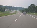
U.S. Route 421 begins at Fort Fisher, North Carolina, and heads generally to the northwest to Michigan City, IndianaMichigan City, Indiana
Michigan City's origins date to 1830, when the land for the city was first purchased by Isaac C. Elston. Elston Middle School, formerly Elston High School, located at 317 Detroit St., is named after the founder....
. Along the way, it passes through Bristol, Tennessee
Bristol, Tennessee
Bristol is a city in Sullivan County, Tennessee, United States. The population was 26,702 at the 2010 census. It is the twin city of Bristol, Virginia, which lies directly across the state line between Tennessee and Virginia. The boundaries of both cities run parallel to each other along State...
, and Virginia
Bristol, Virginia
Bristol is an independent city in Virginia, United States, bounded by Washington County, Virginia, Bristol, Tennessee, and Sullivan County, Tennessee....
, Lexington, Kentucky
Lexington, Kentucky
Lexington is the second-largest city in Kentucky and the 63rd largest in the US. Known as the "Thoroughbred City" and the "Horse Capital of the World", it is located in the heart of Kentucky's Bluegrass region...
, and Indianapolis, Indiana
Indianapolis, Indiana
Indianapolis is the capital of the U.S. state of Indiana, and the county seat of Marion County, Indiana. As of the 2010 United States Census, the city's population is 839,489. It is by far Indiana's largest city and, as of the 2010 U.S...
.
North Carolina
US 421 begins at Fort FisherFort Fisher State Recreation Area
Fort Fisher State Recreation Area is a North Carolina state park in New Hanover County, North Carolina in the United States. Located near Kure Beach, North Carolina, it includes Fort Fisher, site of a major naval engagement during the American Civil War. The recreation area also served as a home...
and heads through North Carolina's southeastern beaches to Wilmington
Wilmington, North Carolina
Wilmington is a port city in and is the county seat of New Hanover County, North Carolina, United States. The population is 106,476 according to the 2010 Census, making it the eighth most populous city in the state of North Carolina...
. It then heads in a northwest direction through Clinton
Clinton, North Carolina
Clinton is the county seat of Sampson County, North Carolina, United States. The population of Clinton is 8,639 according to the 2010 US Census. Clinton is named for American Revolution General Richard Clinton.-History:...
, Dunn
Dunn, North Carolina
Dunn is a city in Harnett County, North Carolina, United States. The population was 9,196 at the 2000 census.It is the birthplace of early an rock and roll guitar player, Link Wray, and General William C. Lee, father of the American Army Airborne. The city's slogan is "It's all right here." The...
, Lillington
Lillington, North Carolina
Lillington is a town in Harnett County, North Carolina, United States. The population was 2,915 at the 2000 census. It is the county seat of Harnett County.-Geography:Lillington is located at ....
, Sanford
Sanford, North Carolina
Sanford is a city in Lee County, North Carolina, United States. The population was 23,220 at the 2000 census. It is the county seat of Lee County.-Geography:Sanford is located at ....
and Siler City
Siler City, North Carolina
Siler City is a town in Chatham County, North Carolina, United States. The population is right at 8,747 within corporate limits and 14,005 within corporate limits and ETJ...
to the Piedmont Triad
Piedmont Triad
The Piedmont Triad, or Triad, is a north-central region of the U.S. state of North Carolina that consists of the area within and surrounding the three major cities of Greensboro, Winston-Salem, and High Point. This close group or "triad" of cities lies in the Piedmont geographical region of the...
region. Major highway junctures between north of Wilmington and Greensboro are NC 11, I-95, .S. Route 401 (North Carolina)|US 401, US 1, US 64 and I-85. In Greensboro, it follows the Greensboro Urban Loop
Greensboro Urban Loop
The Greensboro Urban Loop is a planned 41-mile beltway around Greensboro, North Carolina, United States. The loop carries Interstate 85 and U.S. Route 421 on its southern section, and Interstate 73 from U.S. 220 to Bryan Boulevard along the west side of Greensboro...
paired with Interstate 85 south of Greensboro and I-73
Interstate 73
Interstate 73 is a main route of the Interstate Highway System, currently located entirely within the U.S. state of North Carolina. It is part of a longer planned corridor, defined by various Federal laws to run from Myrtle Beach, South Carolina, to Grayling, Michigan, but only the part south of...
northwest of Greensboro. It then connects to I-40 towards Forsyth County as it becomes its own freeway along the former Interstate 40 alignment known as Business 40. Major intersections are NC 66
North Carolina Highway 66
North Carolina Highway 66 is a highway running from Horneytown Road in Forsyth County to NC 89 in Johnstown.-Major intersections:...
, US 158
U.S. Route 158
U.S. Route 158 is an east–west United States highway that runs for from Mocksville to Nags Head, entirely in the U.S. state of North Carolina.-Route description:...
and US 52 between Greensboro and Winston-Salem. After Winston-Salem
Winston-Salem, North Carolina
Winston-Salem is a city in the U.S. state of North Carolina, with a 2010 population of 229,617. Winston-Salem is the county seat and largest city of Forsyth County and the fourth-largest city in the state. Winston-Salem is the second largest municipality in the Piedmont Triad region and is home to...
, it intersects I-40 once again but continues westerly passing through Lewisville
Lewisville, North Carolina
Lewisville is a village in Forsyth County, North Carolina, United States. The population was 12,639 at the 2010 census. It is a Piedmont Triad community.-Geography:Lewisville is located at ....
, Yadkinville
Yadkinville, North Carolina
Yadkinville is a town in Yadkin County, North Carolina, United States. The population was 2,818 at the 2000 census. Located in the Piedmont Triad, it is the county seat and largest city of Yadkin County.-Geography:Yadkinville is located at ....
, Wilkesboro
Wilkesboro, North Carolina
Wilkesboro is a town in and the county seat of Wilkes County, North Carolina, United States. The population was 3,159 at the 2000 census, and it is the second largest municipality in the county. The 2010 Census listed the town's population at 3,044. The town is located along the south bank of the...
and Boone
Boone, North Carolina
Boone is a town located in the Blue Ridge Mountains of western North Carolina, United States. Boone's population was reported as 17,122, as of 2010...
. Major highway junctions between Winston-Salem and Boone are US 601, I-77
Interstate 77
Interstate 77 is an Interstate Highway in the eastern United States. It traverses diverse terrain, from the mountainous state of West Virginia to the rolling farmlands of North Carolina and Ohio. It largely supplants the old U.S...
, NC 16, Blue Ridge Parkway
Blue Ridge Parkway
The Blue Ridge Parkway is a National Parkway and All-American Road in the United States, noted for its scenic beauty. It runs for 469 miles , mostly along the famous Blue Ridge, a major mountain chain that is part of the Appalachian Mountains...
, US 221 and US 321. US 421 continues westerly into Tennessee towards Mountain City, Tennessee
Mountain City, Tennessee
Mountain City is a town in Johnson County, Tennessee, United States. The population was 2,383 at the 2000 census. It is the northeasternmost county seat in Tennessee; Mountain City is the county seat of Johnson County.-History:...
. US 421 is a limited access freeway through Siler City northward. US 421 is a divided highway from north of NC 49 to the Greensboro Urban Loop
Greensboro Urban Loop
The Greensboro Urban Loop is a planned 41-mile beltway around Greensboro, North Carolina, United States. The loop carries Interstate 85 and U.S. Route 421 on its southern section, and Interstate 73 from U.S. 220 to Bryan Boulevard along the west side of Greensboro...
. US 421 is a limited access freeway from this point all of the way to Wilkesboro
Wilkesboro, North Carolina
Wilkesboro is a town in and the county seat of Wilkes County, North Carolina, United States. The population was 3,159 at the 2000 census, and it is the second largest municipality in the county. The 2010 Census listed the town's population at 3,044. The town is located along the south bank of the...
.
Tennessee
US Highway 421 enters Tennessee from North Carolina in TradeTrade, Tennessee
Trade is an unincorporated community in Johnson County, Tennessee, United States. It is easternmost community in the state and is located in the Blue Ridge Mountains, at the headwaters of Roan Creek. The community is located between the towns of Mountain City and Boone, North Carolina, along US-421...
. It is the oldest crossroads community in Tennessee and is the easternmost part of the state. The road "as the crow would fly" is a short distance in Volunteer State but traverses through two mountain ranges. After Trade, it ventures into Mountain City
Mountain City, Tennessee
Mountain City is a town in Johnson County, Tennessee, United States. The population was 2,383 at the 2000 census. It is the northeasternmost county seat in Tennessee; Mountain City is the county seat of Johnson County.-History:...
through a 40 mph (17.9 m/s) zone while bypassing the downtown area. After Mountain City, begins the two mountain ranges and in between them is the area of Shady Valley
Shady Valley, Tennessee
Shady Valley is an unincorporated community in Johnson County in the northeastern corner of the U.S. state of Tennessee. It is just outside of Cherokee National Forest. Shady Valley is also the name of the valley in which the town is located.-Natural history:...
. After the second mountain range, it flattens out after the south Holston River heading towards Bristol
Bristol, Tennessee
Bristol is a city in Sullivan County, Tennessee, United States. The population was 26,702 at the 2010 census. It is the twin city of Bristol, Virginia, which lies directly across the state line between Tennessee and Virginia. The boundaries of both cities run parallel to each other along State...
. US 421 enters Virginia on the Old Dominion side of Bristol. Major highway junctions between the NC and VA state lines are SR-67
Tennessee State Route 67
State Route 67 is a state-maintained highway in northeastern Tennessee, including a four-lane divided highway segments in both Washington County and Carter County, and part of a significant two-lane segment passing over the Butler Bridge some above the TVA Watauga Reservoir near Butler in Johnson...
in Mountain City, SR-91 the new Mountain City bypass, SR-394, and US 11E
U.S. Route 11E
U.S. Route 11E is a divided highway of US 11 in the U.S. states of Tennessee and Virginia. The U.S. Highway, which is complemented by US 11W to the north and west, runs from US 11, US 11W, and US 70 in Knoxville, Tennessee north and east to US 11, US 11E, US 19, and US 421 in Bristol, Virginia...
.
Virginia
US 421 enters from Tennessee in BristolBristol, Virginia
Bristol is an independent city in Virginia, United States, bounded by Washington County, Virginia, Bristol, Tennessee, and Sullivan County, Tennessee....
and goes west to Weber City
Weber City, Virginia
Weber City is an incorporated town in Scott County, Virginia, United States. The population was 1,327 at the 2010 census. It is part of the Kingsport–Bristol –Bristol Metropolitan Statistical Area, which is a component of the Johnson City–Kingsport–Bristol, TN-VA Combined...
, Duffield
Duffield, Virginia
Duffield is a town in Scott County, Virginia, United States. The population was 91 at the 2010 census. It is part of the Kingsport–Bristol –Bristol Metropolitan Statistical Area, which is a component of the Johnson City–Kingsport–Bristol, TN-VA Combined Statistical Area – commonly known as...
, and Pennington Gap
Pennington Gap, Virginia
Pennington Gap is the most populous town in Lee County, Virginia, United States. The population was 1,781 at the 2000 census.The Lee Regional Medical Center is in Pennington Gap, and the United States Penitentiary, Lee is nearby.-Geography:...
in Southwest Virginia. The route goes through the Cumberland and Powell Mountains, and goes by Natural Tunnel State Park
Natural Tunnel State Park
Natural Tunnel State Park is a Virginia state park, centered around the Natural Tunnel, a massive naturally formed cave that is so large it is used as a railroad tunnel...
near Duffield.
Kentucky
US 421 enters the Bluegrass State from the Pennington Gap area in Virginia into Harlan CountyHarlan County, Kentucky
Harlan County is a county located in the U.S. state of Kentucky. It was formed in 1819. As of 2000, the population was 33,200. Its county seat is Harlan...
. For the distance between the state line and closer to Hal Rogers Parkway
Hal Rogers Parkway
The Hal Rogers Parkway, formerly named the Daniel Boone Parkway, connects London and Hazard in southeastern Kentucky. This toll road opened in November 1971 and the tolls were removed June 1, 2003. The original extent of the highway was to be instead of today's 62.90, with that mileage to have...
, it is a major north-south two lane highway in eastern Kentucky. However, its passing zones are largely limited to a stretch after the Virginia line, through Harlan and along US 119
U.S. Route 119
U.S. Route 119, commonly abbreviated as US 119, is a spur of US 19. It is a north–south route that was an original United States highway of 1926. It is often referred to as Corridor G east of US 23 and KY 80 in Kentucky to Interstate 64 at Charleston, West Virginia.- Kentucky :US 119 is a two...
. US 421 then crosses Pine Mountain and enters Leslie County
Leslie County, Kentucky
Leslie County is a county located in the U.S. state of Kentucky. As of 2000, the population was 12,401. Its county seat is Hyden. The county is named for Preston H. Leslie, Governor of Kentucky...
, turning west at Hyden
Hyden, Kentucky
Hyden is a city in Leslie County, Kentucky, United States. The population was 365 at the 2010 census. It is the county seat of Leslie County. It is located at the junction of U.S. Route 421 and Kentucky Route 80, along the Middle Fork of the Kentucky River....
and paralleling the Hal Rogers Parkway, which is formerly Daniel Boone Parkway, which likely precludes any addition of passing zones in the future. Therefore, this is a local road but maintains a 55 mph (24.6 m/s) speed limit for the most part. Between Manchester
Manchester, Kentucky
As of the census of 2000, there were 1,738 people, 778 households, and 455 families residing in the city. The population density was 1,148.4 people per square mile . There were 844 housing units at an average density of 557.7 per square mile...
and McKee
McKee, Kentucky
As of the census of 2000, there were 878 people, 359 households, and 232 families residing in the town. The population density was 385.3 people per square mile . There were 402 housing units at an average density of 176.4 per square mile . The racial makeup of the city was 99.54% White, 0.11% Black...
, it functions as more of a local road with many curves. The roadway improves as it descends from the Cumberland Plateau into the Bluegrass Region at Big Hill in Madison County
Madison County, Kentucky
Madison County is a county located in the U.S. state of Kentucky. As of 2008, the population was 82,192. Its county seat is Richmond. The county is named for Virginia statesman James Madison, who later became the fourth President of the United States. This is also where famous pioneer Daniel...
near Berea
Berea, Kentucky
-Demographics:As of the census of 2000, there were 9,851 people, 3,693 households, and 2,426 families residing in the city. The population density was 1,055.4 people per square mile . There were 4,115 housing units at an average density of 440.9 per square mile...
. It joins US 25
U.S. Route 25
U.S. Route 25 is a north–south United States highway that runs for from Brunswick, Georgia to the Ohio state line in Covington, Kentucky.-Georgia:...
at the Blue Grass Army Depot south of Richmond
Richmond, Kentucky
There were 10,795 households out of which 24.4% had children under the age of 18 living with them, 35.2% were married couples living together, 12.8% had a female householder with no husband present, and 48.6% were non-families. Of all households, 34.7% were made up of individuals and 8.8% had...
and roughly parallels I-75 towards Lexington
Lexington, Kentucky
Lexington is the second-largest city in Kentucky and the 63rd largest in the US. Known as the "Thoroughbred City" and the "Horse Capital of the World", it is located in the heart of Kentucky's Bluegrass region...
. Through Lexington, it is Richmond Road, Main Street and Leestown Road, collectively the first major thoroughfare in Kentucky. Leestown, on the Kentucky River
Kentucky River
The Kentucky River is a tributary of the Ohio River, long, in the U.S. state of Kentucky. The river and its tributaries drain much of the central region of the state, with its upper course passing through the coal-mining regions of the Cumberland Mountains, and its lower course passing through the...
, was established before the state capital of Frankfort
Frankfort, Kentucky
Frankfort is a city in Kentucky that serves as the state capital and the county seat of Franklin County. The population was 27,741 at the 2000 census; by population it is the 5th smallest state capital in the United States...
. The segment between Lexington and Frankfort was once designated KY 50, suggesting its importance, but the number was abandoned, perhaps at the time it was made part of US 421. US 62
U.S. Route 62
U.S. Route 62 runs from the US-Mexico border at El Paso, Texas to Niagara Falls, New York, near the United States-Canada border. It is the only east-west US Route that connects Mexico and Canada.Parts of U.S...
runs briefly with US 421 in this section. I-64 and US 60
U.S. Route 60
U.S. Route 60 is an east–west United States highway, running from the Atlantic Ocean on the east coast in Virginia to western Arizona. Despite the final "0" in its number, indicating a transcontinental designation, the 1926 route formerly ended in Springfield, Missouri, at its intersection...
are the four-lane roads connecting Lexington and Frankfort, but US 421 still provides the most direct route. In Frankfort, US 421 runs with US 60 on the west side of town, then runs withn the city' northern bypass, briefly joining US 127
U.S. Route 127
U.S. Route 127 is a long north–south United States highway in the eastern half of the United States. The southern terminus of the route is at U.S. Route 27 in Chattanooga, Tennessee. The northern terminus is at Interstate 75 near Grayling, Michigan...
. In this section, which runs generally east–west, northbound US 421 runs with southbound US 127 and vice versa. Northbound US 421 traverses the very hilly area northwest of Frankfort, then through Henry
Henry County, Kentucky
As of the census of 2000, there were 15,060 people, 5,844 households, and 4,330 families residing in the county. The population density was . There were 6,381 housing units at an average density of...
and Trimble
Trimble County, Kentucky
Trimble County is a county located in the U.S. state of Kentucky. As of 2000, the population was 8,125. Its county seat is Bedford. The county is named for Robert Trimble. Trimble is a prohibition or dry county. It is part of the Louisville/Jefferson County, KY–IN Metropolitan Statistical...
counties, exiting the state at Milton
Milton, Kentucky
Milton is a city in Trimble County, Kentucky, United States, along the Ohio River. The population was 593 at the 2010 census. The Milton-Madison Bridge connects it to Madison, Indiana and is the only automobile link between the two states for 40 miles in either direction.Milton was founded in 1789,...
, crossing the Ohio River
Ohio River
The Ohio River is the largest tributary, by volume, of the Mississippi River. At the confluence, the Ohio is even bigger than the Mississippi and, thus, is hydrologically the main stream of the whole river system, including the Allegheny River further upstream...
into Madison, Indiana
Madison, Indiana
As of the census of 2000, there were 12,004 people, 5,092 households, and 3,085 families residing in the city. The population density was 1,402.9 people per square mile . There were 5,597 housing units at an average density of 654.1 per square mile...
. Preliminary construction has begun on a replacement bridge at this location.
Indiana
US 421 winds through the southern part of Indiana as it runs from Madison, in the southeastern part of the state, to IndianapolisIndianapolis
Indianapolis is the capital of the U.S. state of Indiana, and the county seat of Marion County, Indiana. As of the 2010 United States Census, the city's population is 839,489. It is by far Indiana's largest city and, as of the 2010 U.S...
. North of Greensburg
Greensburg, Indiana
Greensburg is a city in Decatur County, Indiana, United States. The population was counted at 11,492 at the 2010 census. The city is the county seat of Decatur County....
, US 421 intersects and merges with I-74 west, through the Shelbyville
Shelbyville, Indiana
Shelbyville is a city in Addison Township, Shelby County, Indiana, United States. The population was 17,951 at the 2000 census. The city is the county seat of Shelby County...
area en route to Indianapolis. Originally, US 421 followed Southeastern Ave. into downtown Indianapolis, where it merged with US 40 (Washington St.
Washington Street (Indianapolis)
Washington Street is the primary east-west street in Indianapolis, Indiana, United States. The street follows the route of the National Road for almost all of its length in the city of Indianapolis. For a time, its entire length was designated as U.S...
) to West St., then turned north, following West St., Northwestern Ave. (later MLK Dr.), and Michigan Rd. up to the northwest side of the city. US 421 went past the Pyramids, an Indianapolis landmark. North of Indianapolis, US 421 continues to the north-northwest, providing a direct highway link between Indianapolis and Michigan City
Michigan City, Indiana
Michigan City's origins date to 1830, when the land for the city was first purchased by Isaac C. Elston. Elston Middle School, formerly Elston High School, located at 317 Detroit St., is named after the founder....
. US 421 ends at its junction with US 20 on the south side of Michigan City. Originally, the highway's end was a few miles north at the junction with US 12 near the shores of Lake Michigan.
North Carolina
US 421 mainly followed the same route between Clinton and Wilmington. However, there are several old alignments from Clinton to the Tennessee state line.- US 421 bypasses Clinton, old alignment uses local streets.
- Between Dunn and Sanford, uses an old alignment, fully connected.
- Between Goldston and Greensboro, uses several old alignments but not fully connected.
- Between Greensboro and Wilkesboro, uses multiple old alignments of different alignments. In *addition, they are no longer connected consistently.
- US 421 bypasses Wilkesboro, with a bannered US Business route.
- Between Deep Gap and Boone, uses an old aligmment.
- Between Vilas and the Tennessee state line, uses an old alignment.
Major intersections
- Fort Fisher, North Carolina (southern end)
 U.S. Route 117 in Wilmington, North CarolinaWilmington, North CarolinaWilmington is a port city in and is the county seat of New Hanover County, North Carolina, United States. The population is 106,476 according to the 2010 Census, making it the eighth most populous city in the state of North Carolina...

 U.S. Route 17 / U.S. Route 74 / U.S. Route 76 in Wilmington
 Interstate 140Interstate 140 (North Carolina)Interstate 140 is a part of the Interstate Highway System in the US state of North Carolina. It is a spur route that will run for upon its completion within both New Hanover and Brunswick Counties in serving as a bypass of Wilmington...
north of Wilmington U.S. Route 701 in Clinton, North CarolinaClinton, North CarolinaClinton is the county seat of Sampson County, North Carolina, United States. The population of Clinton is 8,639 according to the 2010 US Census. Clinton is named for American Revolution General Richard Clinton.-History:...
 U.S. Route 13 southeast of Dunn, North CarolinaDunn, North CarolinaDunn is a city in Harnett County, North Carolina, United States. The population was 9,196 at the 2000 census.It is the birthplace of early an rock and roll guitar player, Link Wray, and General William C. Lee, father of the American Army Airborne. The city's slogan is "It's all right here." The...
 Interstate 95 at Dunn
 U.S. Route 301 at Dunn
 U.S. Route 401 at Lillington, North CarolinaLillington, North CarolinaLillington is a town in Harnett County, North Carolina, United States. The population was 2,915 at the 2000 census. It is the county seat of Harnett County.-Geography:Lillington is located at ....

 U.S. Route 1 / U.S. Route 15-501U.S. Route 15-501 in North CarolinaU.S. Route 15-501 in North Carolina is a concurrency of U.S. Route 15 and U.S. Route 501; it traverses approximately across central North Carolina; from Laurinburg to Durham.-Route description:...
in Sanford, North CarolinaSanford, North CarolinaSanford is a city in Lee County, North Carolina, United States. The population was 23,220 at the 2000 census. It is the county seat of Lee County.-Geography:Sanford is located at .... U.S. Route 64 at Siler City, North CarolinaSiler City, North CarolinaSiler City is a town in Chatham County, North Carolina, United States. The population is right at 8,747 within corporate limits and 14,005 within corporate limits and ETJ...
 Interstate 85 at Greensboro, North CarolinaGreensboro, North CarolinaGreensboro is a city in the U.S. state of North Carolina. It is the third-largest city by population in North Carolina and the largest city in Guilford County and the surrounding Piedmont Triad metropolitan region. According to the 2010 U.S...


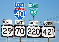
 Interstate 40 / Interstate 85 Business / U.S. Route 29 / U.S. Route 70 / U.S. Route 220 at Greensboro
 Interstate 73 at Greensboro
 Interstate 40 Business / U.S. Route 158U.S. Route 158U.S. Route 158 is an east–west United States highway that runs for from Mocksville to Nags Head, entirely in the U.S. state of North Carolina.-Route description:...
near Winston-Salem, North CarolinaWinston-Salem, North CarolinaWinston-Salem is a city in the U.S. state of North Carolina, with a 2010 population of 229,617. Winston-Salem is the county seat and largest city of Forsyth County and the fourth-largest city in the state. Winston-Salem is the second largest municipality in the Piedmont Triad region and is home to...
 U.S. Route 52 / U.S. Route 311 at Winston-Salem
 U.S. Route 601 at Yadkinville, North CarolinaYadkinville, North CarolinaYadkinville is a town in Yadkin County, North Carolina, United States. The population was 2,818 at the 2000 census. Located in the Piedmont Triad, it is the county seat and largest city of Yadkin County.-Geography:Yadkinville is located at ....
 U.S. Route 21 west of Yadkinville
 Interstate 77 west of Yadkinville
 U.S. Route 221 / U.S. Route 321 at Boone, North CarolinaBoone, North CarolinaBoone is a town located in the Blue Ridge Mountains of western North Carolina, United States. Boone's population was reported as 17,122, as of 2010...
 State Route 67 at Trade, TennesseeTrade, TennesseeTrade is an unincorporated community in Johnson County, Tennessee, United States. It is easternmost community in the state and is located in the Blue Ridge Mountains, at the headwaters of Roan Creek. The community is located between the towns of Mountain City and Boone, North Carolina, along US-421...
 State Route 133 at Shady Valley, TennesseeShady Valley, TennesseeShady Valley is an unincorporated community in Johnson County in the northeastern corner of the U.S. state of Tennessee. It is just outside of Cherokee National Forest. Shady Valley is also the name of the valley in which the town is located.-Natural history:...
 State Route 394 at Bristol, TennesseeBristol, TennesseeBristol is a city in Sullivan County, Tennessee, United States. The population was 26,702 at the 2010 census. It is the twin city of Bristol, Virginia, which lies directly across the state line between Tennessee and Virginia. The boundaries of both cities run parallel to each other along State...