

New York State Route 17
Encyclopedia
New York State Route 17 (NY 17) is a state highway
that extends for 397 miles (638.91 km) through the Southern Tier
and Downstate
regions of New York
in the United States
. It begins at the Pennsylvania state line in Mina
and follows the Southern Tier Expressway and Quickway east through Corning
and Binghamton
to Woodbury
, where it turns south to follow the Orange Turnpike to the New Jersey
state line near Suffern
, where it connects to that state's Route 17
. From the Pennsylvania border to the city of Elmira and from Binghamton to Windsor
, NY 17 is concurrent
with Interstate 86
(I-86). Eventually, the entire east–west portion of NY 17 from the Pennsylvania border to Woodbury will become I-86 as projects to upgrade the route to Interstate Highway standards
are completed.
At 397 miles, NY 17 is the longest state route in New York. It serves 11 counties (Chautauqua
, Cattaraugus
, Allegany
, Steuben
, Chemung
, Tioga
, Broome
, Delaware
, Sullivan
, Orange
, and Rockland
), passes through the cities of Salamanca
, Olean, Corning, Elmira, and Binghamton, and enters the vicinity of several others, including Jamestown
and Middletown
. As it proceeds across the state, it intersects many of New York's Interstate and U.S. Highways, including U.S. Route 219 (US 219) in Salamanca, US 15 (future I-99
) near Corning, I-81 in Binghamton, and I-84 near Middletown. The portion of NY 17 in the vicinity of Waverly
is actually located in Pennsylvania; however, it is maintained by the New York State Department of Transportation
.
The route was assigned in 1924, extending from Westfield
to Suffern via at-grade highways. It was moved onto the Quickway and the Southern Tier Expressway as sections of both were completed from the 1950s to the 1980s. Two of NY 17's suffixed routes, NY 17C
and NY 17M
, follow substantial portions of NY 17's pre-freeway alignment. In 1998, all of NY 17 between the Pennsylvania state line and Harriman was designated as "Future I-86". The westernmost 177 miles (285 km) of the route was designated as I-86 one year later, and the designation has been gradually extended eastward as sections of NY 17 are improved to Interstate Highway standards
.
(I-86) crosses the New York – Pennsylvania border in Mina
, Chautauqua County
. Before its designation as I-86, the portion of that highway in Pennsylvania was known as PA 17. I-86 and NY 17 continue eastward through the Southern Tier
, encountering NY 426
(exit 4) a short distance from the state line prior to meeting NY 76
(exit 6) south of Sherman
. East of exit 8 (NY 394
), I-86 and NY 17 cross Chautauqua Lake
and follow the lake shore eastward to Jamestown
, where it connects to NY 60
at exit 12 due north of the city. East of the city, the expressway meets U.S. Route 62 (US 62) at exit 14 and is joined by the old Erie Railroad
line, which parallels the expressway as it heads across southern New York.
Between exits 17 and 18 (NY 280
), I-86 and NY 17 cross the Allegheny Reservoir
near its northernmost extent. Past NY 280, the freeway runs adjacent to the northern extent of the Allegany State Park
and follows the reservoir and the connecting Allegheny River
eastward to Salamanca
. Near downtown Salamanca, I-86 and NY 17 meet US 219 (exit 21). US 219 joins the expressway east to exit 23 near Carrollton
, where it splits from I-86 and NY 17 and heads toward Bradford, Pennsylvania
, forming the eastern edge of the state park as it heads south. Meanwhile, the expressway continues east to Olean
, where it meets NY 417
(a previous alignment of NY 17) at exit 24 west of town and NY 16
(exit 27) north of the area.
Past Olean, the route drifts northward away from Pennsylvania toward Hornell
, where I-86 and NY 17 intersect NY 36
(exit 34). To the east in Avoca
, the Southern Tier Expressway meets Interstate 390 at exit 36. I-86 and NY 17 southeast from the junction, passing through Bath
on its way an interchange with US 15 in Painted Post
(exit 44). Here, US 15 begins and heads south toward Pennsylvania while I-86 and NY 17 continue east through Corning
to the city of Elmira
. At exit 56 (NY 352
), I-86 temporarily terminates as NY 17 continues eastward toward Binghamton.
 From Elmira to Binghamton, NY 17, the Erie Railroad (now operated by Norfolk Southern as the Southern Tier Line
), and its old alignments generally stay close together. They follow the Chemung River to exit 60 (US 220
in South Waverly, Pennsylvania
) and the Susquehanna River
from east of exit 61 (Waverly, New York
) to Binghamton; on the latter section, both NY 17C
and NY 434
are old NY 17. Between the two rivers, which intersect in Pennsylvania, the general corridor runs just north of the state line in New York. However, NY 17 itself crosses into Pennsylvania between a point west of exit 60 and a point west of exit 61; additionally, all the ramps at exit 60 and portions of the eastbound ramps at exits 59A and 61 are in Pennsylvania. Despite being in Pennsylvania, these roadways are maintained by the New York State Department of Transportation
.
Near downtown Binghamton, NY 17 goes around the side of Prospect Mountain at what is locally known as "Kamikaze
Curve". Heading eastbound, the freeway curves sharply left around the hillside, splits into ramps to Interstate 81 north and south, and curves right to merge into I-81 south as it passes over the Chenango River
. From that point east and southeast about 4 miles (6 km), I-81 and NY 17 run concurrently. NY 17 splits from I-81, the Erie Railroad and the Susquehanna River to the east into Stilson Hollow; from this split (exit 75) to its end, most of NY 17 does not follow the Erie Railroad, which crosses into Pennsylvania several times.
 At the end of Stilson Hollow, NY 17 heads over a summit and into the valley formed by the Occanum Creek. The creek empties into the Susquehanna River
at Windsor
(exit 79), which NY 17 follows southeast to Damascus (exit 80) before turning northeast along Tuscarora Creek. It soon turns east and southeast over a summit, rejoining the Erie Railroad
just north of Gulf Summit. The highway and railroad head east along Oquaga Creek to Deposit (exit 84), where they turn southeast along the West Branch Delaware River
. A gap in the freeway stretches from here to just short of Hancock
(exit 87), the place the West Branch joins with the East Branch Delaware River
. The Erie Railroad continues southeast along the combined Delaware River
, while NY 17 turns east along the valley formed by the East Branch, either closely following or built directly over the abandoned New York, Ontario and Western Railway
to Liberty
.
At East Branch (exit 90), the East Branch Delaware River turns north, and NY 17 continues east with the Beaver Kill to Roscoe
(exit 94), Willowemoc Creek
to Livingston Manor
(exit 96), and Little Beaver Kill to Parksville (the exit 98 at-grade intersection
). The highway and parallel NYO&W pass south over a summit to Liberty
(exits 99–100), and continue along the Middle Mongaup River to Ferndale
(exit 101). The NYO&W turned east there, but NY 17 continues south over a summit and into the Spring Brook and East Mongaup River valleys past Harris
(exit 102). NY 17 then cuts southeast cross-country to Monticello
(exit 104; passing Monticello Raceway
) and beyond, following the old Newburgh and Cochecton Turnpike
(old NY 17) to Bloomingburg
(exit 116). The old Middletown and Wurtsboro Turnpike, also old NY 17, and partially NY 17M
, runs south to Middletown
, which NY 17 cuts cross-country to bypass to the east, rejoining NY 17M - and the main line of the Erie Railroad
- at Goshen
(exit 123). NY 17, its old former alignment (NY 17M) and the Erie run generally east-southeast, partly cross-country and partly through small stream valleys, to the end of the freeway, the directional change in NY 17 from east–west to north–south, and the junction of the Erie with its branch to Newburgh.
 NY 17 heads southwest from the Quickway as an at-grade roadway, passing through the village of Woodbury
before entering the village of Harriman
, where it intersects with the eastern terminus of NY 17M. As the route heads southward from this junction, its signage changes from being East or West to North or South. The route parallels the Thruway as it proceeds through a disjointed piece of Harriman State Park and enters the town of Tuxedo
. While inside the park, NY 17 intersects Arden Valley Road
, a highway that connects to Seven Lakes Drive
deep inside the park. South of Arden Valley Road, NY 17 briefly exits Harriman State Park and enters the hamlet of Southfields, where it intersects with County Route 19 and passes by the Red Apple Rest
, a former restaurant and roadside attraction.
Past the hamlet, the route heads back into the park and intersects with NY 17A
and County Route 106
near the park's western boundary. South of the junction, NY 17 leaves the Park and proceeds through a lightly populated area to the hamlet of Tuxedo Park
. At the Tuxedo Park train station is access to a couple hiking trails in Harriman State Park. The route continues on, paralleling the Thruway into Rockland County
. On the other side of the county line, NY 17 enters the village of Sloatsburg
, where it meets Seven Lakes Drive
and connects to County Route 72
by way of a modified trumpet interchange.
Outside of Sloatsburg, NY 17 winds its way southeasterly along the Ramapo River
and the Thruway through the town of Ramapo
to the hamlet of the same name, based just north of NY 17's junction with NY 59
. Here, NY 17 turns to the southwest, meeting the Thruway at exit 15A before traversing a sparsely developed area of the village of Hillburn
. About 0.75 miles (1.21 km) south of the Thruway, NY 17 curves to the east, passing to the south of the village center as it approaches Interstate 287. At Suffern Road, NY 17 becomes southbound only as it merges onto I-287 and proceeds to the New Jersey
state line, where it connects to New Jersey's Route 17.
called the Liberty Highway, which connected New York City
to Cleveland via Hackensack
, Liberty
, the Southern Tier
, and Erie
. The alignment of the Liberty Highway from Westfield
to Harriman
was largely designated as Route 4, an unsigned legislative route
, by the New York State Legislature in 1908. Legislative Route 4 began at legislative Route 18 (current U.S. Route 20 or US 20) in Westfield and proceeded southeast through Mayville
to Jamestown
on what is now NY 394
and NY 430
. From there, the route headed generally eastward to Salamanca
over modern NY 394, NY 242
, and NY 353
, and southeast to Olean
via NY 417
. At Olean, the route shifted northward, passing through Hinsdale
, Friendship
, and Belvidere on current NY 16
, NY 446
and Allegany County Route 20 before returning southward on what is now NY 19
to access the village of Wellsville
.
 From Wellsville to Andover
and from Jasper
to Corning
, Route 4 followed modern NY 417. In between Andover and Jasper, however, Route 4 veered north on current NY 21
and NY 36
to serve Hornell
. East of Corning, the alignment of legislative Route 4 more closely resembled the modern alignments of the Southern Tier Expressway and the Quickway. Route 4 exited Corning on what is now NY 352
and followed it to Big Flats
, where it broke from NY 352 and proceeded to Horseheads
on Chemung County Route 64 and to Elmira on what is now Lake Road, Madison Avenue and the east end of NY 352
. Between Elmira and Binghamton, Route 4 followed either local roads that were bypassed or upgraded into the Southern Tier Expressway, namely modern NY 17 and Chemung and Tioga County Road 60 from Elmira to Waverly
, NY 17C
between Waverly and Owego
, NY 434
from Owego to Vestal
, and NY 17C and Riverside Drive (via NY 26
) from Vestal to Binghamton.
Route 4 exited the city on US 11 and followed it to Kirkwood Center, a hamlet adjacent to the eastern junction of NY 17 and Interstate 81. From this point to Harriman, except for one section near Middletown
, the path Route 4 followed became the basis for the Quickway several decades later. Between Kirkwood Center and Hancock, Route 4 utilized what was later upgraded into the Quickway (via Broome County Route 28 from Windsor
to Deposit). East of here, it used parallel roads instead: modern "Old Route 17" (Delaware CR 17 and Sullivan CRs 179A to 174) from Deposit to Monticello
, Sullivan CRs 173 to 171 between Monticello and Bloomingburg
, and Orange County Route 76 and NY 17M
from Bloomingburg to Harriman. At Harriman, Route 4 broke from the Liberty Highway and proceeded northeast over current US 6 and NY 293
to Highland Falls
, where it ended at legislative Route 3 (modern US 9W
). The portion of the Liberty Highway between Suffern
and Harriman became part of legislative Route 39-b in 1911; however, this designation was removed on March 1, 1921.
 When New York first signed its state highways with route numbers in 1924, much of legislative Route 4 was designated as NY 17. From Randolph
to Salamanca, NY 17 followed a more southerly routing than Route 4, bypassing Little Valley
to the south in favor of a direct connection between Randolph and Salamanca (current NY 394 and NY 951T). In Vestal, NY 17 was routed along the south bank of the Susquehanna River
, bypassing Endicott
and Johnson City
on what is now NY 434 and Broome County Route 44. Lastly, NY 17 broke from the path of legislative Route 4 in Harriman and followed the former Route 39-b south to the New Jersey
state line at Suffern. As originally laid out, NY 17 was 434 miles (698 km) long. In the 1930 renumbering of state highways in New York, NY 17 basically remained intact. The only changes made at this time were the straightening out of the Olean–Wellsville segment (now via Ceres) and the Andover–Jasper segment (now via Greenwood
).
NY 17 initially reached New Jersey by way of Suffern's Orange Avenue (now US 202) and connected to New Jersey's Route 2 at the state line. By 1932, an alternate route of NY 17 between the New Jersey state line at Hillburn
and the hamlet of Ramapo
on the western bank of the Ramapo River
was designated as NY 339. The route largely followed the path of modern Interstate 287 and the New York State Thruway
between the two locations. It initially became a local road upon crossing into New Jersey; however, Route 2 was realigned ca. 1933 to connect to NY 339 instead of NY 17. In the mid-1930s, the alignments of NY 17 and NY 339 south of Ramapo were flipped, placing NY 17 on the western route. By 1938, NY 17 was relocated onto a new highway through the Hillburn village limits. While the southern half of the new road utilized the old highway, the northern half veered to the west of both Hillburn and old NY 17, bypassing the village before rejoining the old road south of Ramapo.
industry in the Catskill Mountains
region, which began in the 1930s and intensified after World War II
, stretched the rural road to its limits. Scores of hotels, resorts and bungalow colonies attracted hundreds of thousands of vacationing New Yorkers, whose cars left the two-lane NY 17 hopelessly jammed in summer. Many towns, especially the fairly large city of Middletown
, were paralyzed on Friday evenings and Sunday afternoons in the summertime, as traffic passed through local downtowns and their traffic lights. In addition, the tight turns and steep inclines along the route led to numerous fatal crashes, including two milk tanker truck crashes in the mid-1950s. In response, New York State officials planned a four-lane replacement, the first free long-distance expressway in the state and one of the earliest in the United States
. It would replace intersections with well-spaced access ramps, separate grades with flyovers, and allow safe travel at up to 65 mi/h.
The first segment of the new highway extended from Fair Oaks to Goshen
, bypassing the city of Middletown to the northeast. It opened to traffic in July 1951 as a realignment of NY 17. As more sections of the freeway—known as the Quickway—opened up during the 1950s and 1960s, NY 17 was moved onto them. The Quickway was completed by 1968, connecting Binghamton to Harriman by way of a continuous, mostly limited-access highway. Farther west, plans were also in the works to build an expressway across the Southern Tier. The highway was first proposed by New York Governor Thomas Dewey
in 1953, and the first sections of the Southern Tier Expressway were completed in the mid-1960s. At the time, NY 17 followed the entirety of two of the four open sections (Steamburg
to Salamanca and Owego to the Broome County
line) and part of a third (Corning to Lowman via Elmira).
As more continuous pieces of the expressway opened during the 1970s, NY 17 was realigned onto them, with much of NY 17's old alignment becoming NY 394, NY 417, or NY 17C. By 1980, the expressway was complete from Bemus Point
to Binghamton except for two areas near Salamanca and Corning. Although NY 17 continued to extend northwestward along its original alignment from Bemus Point to Westfield, both highways were also designated as parts of NY 430 and NY 394 in anticipation of the completion of the Southern Tier Expressway west of Chautauqua Lake
, which NY 17 would be rerouted to follow. This segment was built in stages during the 1980s as a super two
highway; it was widened to four lanes in 1997. The portions of the freeway in and around Salamanca and Corning were completed in the late 1980s and mid-1990s, completing the conversion of NY 17 into a continuous, mostly limited-access highway from the Pennsylvania state line to Harriman.
On December 3, 1999, the westernmost 177 miles (284.85 km) of NY 17 were designated as part of Interstate 86
, a new route that had been written into law a year earlier. As legislated, I-86 will eventually extend eastward along the length of both the Southern Tier Expressway and the Quickway to the New York State Thruway in Harriman once both highways are brought up to Interstate Highway standards
. I-86 was extended east to Horseheads in 2004 and Elmira in 2008; additionally, a 10 miles (16 km) stretch of NY 17 in central Broome County
was designated as I-86 in 2006. The remainder of NY 17 west of I-87
is slated to be designated as I-86 in about 2012 after the remaining at-grade sections are eliminated and the highway is brought up to Interstate Highway standards.
 NY 17 has had 13 suffixed routes bearing 11 different designations. Five are still assigned to their routes, while eight have been removed or renumbered.
|colspan=6 align="center"|For exits 4 through 57, see I-86; I-86 temporarily ends at exit 57
|-
|rowspan=4|Chemung
|Ashland
|195.68
|58
|CR 8 – Lowman, Wellsburg
|
|-
|colspan=5 align="center"|gap in freeway
|-
|rowspan=2|Chemung
|200.96
|59
|
|Eastern terminus of NY 427
|-
|203.22
|59A
|Wilawana, PA
|
|-
|Bradford (PA)
|South Waverly
|205.19
|60
|
|
|-
|rowspan=6|Tioga
|Waverly
|206.44
|61
|
|Southern terminus of NY 34; northern terminus of PA 199
|-
|rowspan=2|Nichols
|214.53
|62
|
|
|-
|219.26
|63
|Lounsberry
|
|-
|rowspan=3|Owego
|223.67
|64
|
|
|-
|225.50
|65
|
|
|-
|230.99
|66
|
|Access via NY 962J
|-
|rowspan=17|Broome
|rowspan=2|Vestal
|237.00
|67
|
|Split into 67S (south) and 67N (north)
|-
|238.00
|68
|Old Vestal Road
|Eastbound exit and westbound entrance
|-
|rowspan=3|Union
|239.36
|rowspan=2|69
|
|Eastbound exit and westbound entrance
|-
|240.61
|
|Westbound exit and eastbound entrance
|-
|241.43
|70
|
|Split into 70S (NY 201 south) and 70N (shopping mall)
|-
|Union
-Dickinson
town line
|242.63
|71
|Airport Road – Greater Binghamton Airport
, Johnson City
|Split into 71S (Johnson City) and 71N (Airport Road) westbound
|-
|rowspan=5|Binghamton
|
|72
|Mygatt Street / Clinton Street
|Westbound exit only
|-
|244.78
|72
|
|Eastbound exit only
|-
|244.91
|
|
|I-81 joins eastbound and leaves westbound
|-
|245.39
|4
|
|Split into 4S (south) and 4N (north)
|-
|245.78
|rowspan=2|3
|Broad Avenue
|Westbound exit and eastbound entrance
|-
|Kirkwood
|249.07
|Industrial Park
|Eastbound exit and westbound entrance
|-
|colspan=5 align="center"|I-86 resumes at exit 75 and ends at exit 79
|-
|rowspan=2|Windsor
|261.39
|80
|Damascus
|
|-
|264.09
|81
|Earl Bosket Road
|
|-
|rowspan=2|Sanford
|269.74
|82
|
|
|-
|271.02
|83
|Deposit, Oquaga Lake
|
|-
|rowspan=8|Delaware
|Deposit
|274.32
|84
|
|
|-
|colspan=5 align="center"|gap in freeway
|-
|rowspan=4|Hancock
|285.25
|87
|
|
|-
|
|87A
|
|Westbound exit and eastbound entrance
|-
|292.84
|89
|Fishs Eddy
|
|-
|296.74
|90
|
|
|-
|rowspan=2|Colchester
|303.13
|92
|Horton, Cooks Falls
|
|-
|304.98
|93
|Cooks Falls
|Westbound exit and eastbound entrance
|-
|rowspan=23|Sullivan
|rowspan=3|Rockland
|310.37
|94
|
|
|-
|316.36
|96
|Livingston Manor
|
|-
|318.59
|97
|Morsston
|
|-
|colspan=5 align="center"|gap in freeway
|-
|rowspan=5|Liberty
|321.39
|98
|Cooley, Parksville
|At-grade intersection with traffic signal
|-
|324.63
|99
|
|
|-
|326.12
|100A
|
|Westbound exit and eastbound entrance
|-
|326.49
|100
|
|
|-
|327.47
|101
|Ferndale
, Swan Lake
|No westbound entrance
|-
|rowspan=10|Thompson
|331.84
|102
|Harris
, Bushville
|
|-
|334.57
|103
|Rapp Road
|Westbound exit and eastbound entrance
|-
|335.91
|104
|
|
|-
|337.26
|105
|
|Split into 105A (south) and 105B (north)
|-
|339.37
|106
|Monticello
|No eastbound exit
|-
|340.55
|107
|Bridgeville
, South Fallsburg
|
|-
|342.41
|108
|Bridgeville
|Eastbound exit and entrance
|-
|343.59
|109
|Rock Hill
, Woodridge
|
|-
|343.99
|110
|Lake Louise Marie, Wanaksink Lake
|
|-
|344.74
|111
|Wolf Lake
|Eastbound exit and entrance
|-
|rowspan=4|Mamakating
|347.64
|112
|Masten Lake, Yankee Lake
|
|-
|349.95
|113
|
|
|-
|352.28
|114
|Wurtsboro
, Highview
|Westbound exit only
|-
|354.33
|115
|Burlingham Road
|Westbound exit and eastbound entrance
|-
|rowspan=21|Orange
|rowspan=6|Wallkill
|354.93
|116
|
|
|-
|
|118
|Fair Oaks
|
|-
|359.20
|119
|
|
|-
|361.93
|120
|
|Split into 120W (west) and 120E (east) eastbound
|-
|362.85
|121
|
|Split into 121W (west) and 121E (east)
|-
|
|122
|CR 67 (East Main Street) / Crystal Run Road
|
|-
|rowspan=4|Goshen
|
|122A
|Fletcher Street – Goshen
|
|-
|366.93
|123
|
|Westbound exit and eastbound entrance; US 6 and NY 17M join eastbound and leave westbound
|-
|367.32
|124
|
|
|-
|367.90
|125
|
|NY 17M joins westbound and leaves eastbound
|-
|rowspan=2|Chester
|371.39
|126
|
|
|-
|373.22
|127
|Greycourt Road – Sugar Loaf
, Warwick
|Westbound exit and eastbound entrance
|-
|rowspan=2|Blooming Grove
|
|128
|CR 51 – Oxford Depot
|Westbound exit only
|-
|
|129
|Museum Village Road
|No westbound entrance
|-
|Monroe
|376.72
|130
|
|
|-
|rowspan=3|Woodbury
|379.68
|130A
|
|Eastbound exit and westbound entrance; US 6 joins westbound and leaves eastbound
|-
|380.27
|131
|
|Southern terminus of NY 32
|-
|colspan=4 align="center"|East end of freeway section
|-
|rowspan=2|Harriman
|380.46
|
|
|Interchange
|-
|381.45
|
|
|Eastern terminus of NY 17M
|-
|Tuxedo
|387.32
|
|
|Hamlet of Southfields; southern terminus of NY 17A
|-
|rowspan=4|Rockland
|rowspan=2|Hillburn
|394.37
|
|
|Western terminus of NY 59
|-
|394.83
|
|
|Exit 15A (I-87 / Thruway)
|-
|rowspan=2|Suffern
|396.73
|
|
|Northern terminus of I-287 / NY 17 overlap; exit 15 (I-87 / Thruway)
|-
|396.84
|
|
|Continuation into New Jersey
Former alignments
State highway
State highway, state road or state route can refer to one of three related concepts, two of them related to a state or provincial government in a country that is divided into states or provinces :#A...
that extends for 397 miles (638.91 km) through the Southern Tier
Southern Tier
The Southern Tier is a geographical term that refers to the counties of New York State west of the Catskill Mountains along the northern border of Pennsylvania. It is a loosely defined term that generally includes the counties that border Pennsylvania west of Delaware County inclusive...
and Downstate
Downstate New York
Downstate New York is a term denoting the southeastern portion of New York State, United States, in contrast to Upstate New York. The term "Downstate New York" has significantly less currency than its counterpart term "Upstate New York", and the Downstate region is often not regarded as one...
regions of New York
New York
New York is a state in the Northeastern region of the United States. It is the nation's third most populous state. New York is bordered by New Jersey and Pennsylvania to the south, and by Connecticut, Massachusetts and Vermont to the east...
in the United States
United States
The United States of America is a federal constitutional republic comprising fifty states and a federal district...
. It begins at the Pennsylvania state line in Mina
Mina, New York
Mina is a town in Chautauqua County, New York, USA. The population was 1,176 at the 2000 census.The Town of Mina is at the western county border. The town is best known as a summer resort area...
and follows the Southern Tier Expressway and Quickway east through Corning
Corning (city), New York
Corning is a city in Steuben County, New York, United States, on the Chemung River. The population was 10,842 at the 2000 census. It is named for Erastus Corning, an Albany financier and railroad executive who was an investor in the company that developed the community.- Overview :The city of...
and Binghamton
Binghamton, New York
Binghamton is a city in the Southern Tier of New York in the United States. It is near the Pennsylvania border, in a bowl-shaped valley at the confluence of the Susquehanna and Chenango Rivers...
to Woodbury
Woodbury, Orange County, New York
Woodbury is a town and village in Orange County, New York, United States. The town population was 9,460 at the 2000 census. The village was incorporated in 2006 and comprises all of the town that is not part of the village of Harriman. The region was once called Woodbury Clove...
, where it turns south to follow the Orange Turnpike to the New Jersey
New Jersey
New Jersey is a state in the Northeastern and Middle Atlantic regions of the United States. , its population was 8,791,894. It is bordered on the north and east by the state of New York, on the southeast and south by the Atlantic Ocean, on the west by Pennsylvania and on the southwest by Delaware...
state line near Suffern
Suffern, New York
Suffern is a village in the Town of Ramapo, Rockland County, New York, United States located north of the State of New Jersey; east of Hillburn; south of Montebello and west of Airmont...
, where it connects to that state's Route 17
Route 17 (New Jersey)
Route 17 is a state highway in Bergen County, New Jersey, United States, that provides a major route from the George Washington Bridge, Lincoln Tunnel and other northeast New Jersey points to the New York State Thruway at Suffern, New York...
. From the Pennsylvania border to the city of Elmira and from Binghamton to Windsor
Windsor (village), New York
Windsor is a village in Broome County, New York, United States. The population was 901 at the 2000 census. It is part of the Binghamton Metropolitan Statistical Area....
, NY 17 is concurrent
Concurrency (road)
A concurrency, overlap, or coincidence in a road network is an instance of one physical road bearing two or more different highway, motorway, or other route numbers...
with Interstate 86
Interstate 86 (east)
Interstate 86 is an Interstate Highway that extends for through northwestern Pennsylvania and southern New York in the United States...
(I-86). Eventually, the entire east–west portion of NY 17 from the Pennsylvania border to Woodbury will become I-86 as projects to upgrade the route to Interstate Highway standards
Interstate Highway standards
Standards for Interstate Highways in the United States are defined by the American Association of State Highway and Transportation Officials in the publication A Policy on Design Standards - Interstate System...
are completed.
At 397 miles, NY 17 is the longest state route in New York. It serves 11 counties (Chautauqua
Chautauqua County, New York
-Major highways:* Interstate 86/New York State Route 17 * Interstate 90 * U.S. Route 20* U.S. Route 62* New York State Route 5* New York State Route 39* New York State Route 60* New York State Route 394...
, Cattaraugus
Cattaraugus County, New York
Cattaraugus County is a county located in the U.S. state of New York. As of the 2010 census, the population was 80,317. The county seat is Little Valley.-History:...
, Allegany
Allegany County, New York
Allegany County is a county located in the U.S. state of New York. As of the 2010 census, the population was 48,946. Its name derives from a Delaware Indian word, applied by settlers of Western New York State to a trail that followed the Allegheny River. Its county seat is...
, Steuben
Steuben County, New York
Steuben County is a county located in the U.S. state of New York. As of the 2010 census, the population was 98,990. Its name is in honor of Baron von Steuben, a German general who fought on the American side in the American Revolutionary War, though it is not pronounced the same...
, Chemung
Chemung County, New York
Chemung County is a county located in the U.S. state of New York. It is part of the 'Elmira, New York Metropolitan Statistical Area' which encompasses all of Chemung County. As of the 2010 census, the population was 88,830. Its name is derived from the name of a Delaware Indian village . Its...
, Tioga
Tioga County, New York
As of the census of 2010, there were 51,125 people residing in the county, with 22,203 housing units, of these 20,350 occupied, 1,853 vacant. The population density was 98 people per square mile...
, Broome
Broome County, New York
Broome County is a county located in the U.S. state of New York. As of the 2010 census, the population was 200,600. It was named in honor of John Broome, who was lieutenant governor in 1806 when Broome County was established. Its county seat is Binghamton, which is also its major city. The current...
, Delaware
Delaware County, New York
Delaware County is a county located in the U.S. state of New York. As of 2010 the population was 47,980. The county seat is Delhi. It is named after the Delaware River, which was named in honor of Thomas West, 3rd Baron De La Warr, appointed governor of Virginia in 1609.-History:When counties...
, Sullivan
Sullivan County, New York
Sullivan County is a county located in the U.S. state of New York. As of the 2010 census, the population was 77,547. The county seat is Monticello. The name is in honor of Major General John Sullivan, who was a hero in the American Revolutionary War...
, Orange
Orange County, New York
Orange County is a county located in the U.S. state of New York. It is part of the Poughkeepsie–Newburgh–Middletown, NY Metropolitan Statistical Area and is located at the northern reaches of the New York metropolitan area. The county sits in the state's scenic Mid-Hudson Region of the Hudson Valley...
, and Rockland
Rockland County, New York
Rockland County is a suburban county 15 miles to the northwest of Manhattan and part of the New York City Metropolitan Area, in the U.S. state of New York. It is the southernmost county in New York west of the Hudson River, and the smallest county in New York outside of New York City. The...
), passes through the cities of Salamanca
Salamanca (city), New York
Salamanca is a city in Cattaraugus County, New York, United States, located inside the Allegany Indian Reservation. The population was 6,097 at the 2000 census.-Geography:...
, Olean, Corning, Elmira, and Binghamton, and enters the vicinity of several others, including Jamestown
Jamestown, New York
Jamestown is a city in Chautauqua County, New York in the United States. The population was 31,146 at the 2010 census.The City of Jamestown is adjacent to Town of Ellicott and is at the southern tip of Chautauqua Lake...
and Middletown
Middletown, Orange County, New York
Middletown is a city in Orange County, New York, United States. It lies in New York's Hudson Valley region, near the Wallkill River and the foothills of the Shawangunk Mountains. Middletown is situated between Port Jervis and Newburgh, New York. The city's population was 25,388 at the 2000 census...
. As it proceeds across the state, it intersects many of New York's Interstate and U.S. Highways, including U.S. Route 219 (US 219) in Salamanca, US 15 (future I-99
Interstate 99
Interstate 99 is an intrastate Interstate Highway located in central Pennsylvania in the United States. The southern terminus of the route is at exit 146 of the Pennsylvania Turnpike north of Bedford, where the road continues south as U.S. Route 220 . The northern terminus is at...
) near Corning, I-81 in Binghamton, and I-84 near Middletown. The portion of NY 17 in the vicinity of Waverly
Waverly, Tioga County, New York
----Waverly is the largest village in Tioga County, New York, United States. It is located southeast of Elmira in the Southern Tier region. This village was incorporated as the southwest part of the town of Barton in 1854...
is actually located in Pennsylvania; however, it is maintained by the New York State Department of Transportation
New York State Department of Transportation
The New York State Department of Transportation is responsible for the development and operation of highways, railroads, mass transit systems, ports, waterways and aviation facilities in the U.S...
.
The route was assigned in 1924, extending from Westfield
Westfield (village), New York
Westfield is a village in Chautauqua County, New York, United States. USA. The population was 3,481 at the 2010 census.The Village of Westfield lies within the Town of Westfield in the northern part of the county...
to Suffern via at-grade highways. It was moved onto the Quickway and the Southern Tier Expressway as sections of both were completed from the 1950s to the 1980s. Two of NY 17's suffixed routes, NY 17C
New York State Route 17C
New York State Route 17C is a state highway in the Southern Tier of New York. Its western terminus is at an intersection with NY 34 in Waverly, Tioga County while its eastern terminus is at an intersection with U.S. Route 11 in Binghamton, Broome County...
and NY 17M
New York State Route 17M
New York State Route 17M is an east–west state highway in Orange County, New York, in the United States. It extends for from west of the city of Middletown to what is currently the north–south section of NY 17 just southeast of the village of Harriman...
, follow substantial portions of NY 17's pre-freeway alignment. In 1998, all of NY 17 between the Pennsylvania state line and Harriman was designated as "Future I-86". The westernmost 177 miles (285 km) of the route was designated as I-86 one year later, and the designation has been gradually extended eastward as sections of NY 17 are improved to Interstate Highway standards
Interstate Highway standards
Standards for Interstate Highways in the United States are defined by the American Association of State Highway and Transportation Officials in the publication A Policy on Design Standards - Interstate System...
.
Pennsylvania to Elmira
NY 17 begins at the point where Interstate 86Interstate 86 (east)
Interstate 86 is an Interstate Highway that extends for through northwestern Pennsylvania and southern New York in the United States...
(I-86) crosses the New York – Pennsylvania border in Mina
Mina, New York
Mina is a town in Chautauqua County, New York, USA. The population was 1,176 at the 2000 census.The Town of Mina is at the western county border. The town is best known as a summer resort area...
, Chautauqua County
Chautauqua County, New York
-Major highways:* Interstate 86/New York State Route 17 * Interstate 90 * U.S. Route 20* U.S. Route 62* New York State Route 5* New York State Route 39* New York State Route 60* New York State Route 394...
. Before its designation as I-86, the portion of that highway in Pennsylvania was known as PA 17. I-86 and NY 17 continue eastward through the Southern Tier
Southern Tier
The Southern Tier is a geographical term that refers to the counties of New York State west of the Catskill Mountains along the northern border of Pennsylvania. It is a loosely defined term that generally includes the counties that border Pennsylvania west of Delaware County inclusive...
, encountering NY 426
New York State Route 426
New York State Route 426 is a state highway located entirely within Chautauqua County, New York, United States. It runs just over from one section of the Pennsylvania state line to another, passing through two small hamlets and providing the Southern Tier Expressway with its westernmost...
(exit 4) a short distance from the state line prior to meeting NY 76
New York State Route 76
New York State Route 76 is located entirely within Chautauqua County, New York, United States. It runs north–south from NY 474 in the hamlet of North Clymer in the town of Clymer at its southern end to NY 5 along the Lake Erie shoreline in the town of Ripley...
(exit 6) south of Sherman
Sherman (village), New York
Sherman is a village in the town of Sherman, Chautauqua County, New York, USA. The village lies in the northern part of the town at intersections of Routes 15, 18, NY-76 and NY-430. The population was 714 at the 2000 census.- History :...
. East of exit 8 (NY 394
New York State Route 394
New York State Route 394 is a state highway located within Cattaraugus and Chautauqua Counties in southwestern New York, United States. Its western terminus is located on the shore of Lake Erie at an intersection with NY 5 in the Westfield hamlet of Barcelona...
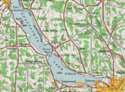
), I-86 and NY 17 cross Chautauqua Lake
Chautauqua Lake
Chautauqua Lake is located entirely within Chautauqua County, New York, USA. The lake is approximately long and wide at its greatest width. The surface area is approximately 13,000 acres . The maximum depth is about 78 feet...
and follow the lake shore eastward to Jamestown
Jamestown, New York
Jamestown is a city in Chautauqua County, New York in the United States. The population was 31,146 at the 2010 census.The City of Jamestown is adjacent to Town of Ellicott and is at the southern tip of Chautauqua Lake...
, where it connects to NY 60
New York State Route 60
New York State Route 60 is a north–south state highway in Chautauqua County, New York, United States. The southern terminus of the route is at an intersection with U.S. Route 62 south of the city of Jamestown in the town of Kiantone. Its northern terminus is at a junction with NY 5...
at exit 12 due north of the city. East of the city, the expressway meets U.S. Route 62 (US 62) at exit 14 and is joined by the old Erie Railroad
Erie Railroad
The Erie Railroad was a railroad that operated in New York State, New Jersey, Pennsylvania, Ohio, Indiana, and Illinois, originally connecting New York City with Lake Erie...
line, which parallels the expressway as it heads across southern New York.
Between exits 17 and 18 (NY 280
New York State Route 280
New York State Route 280 is a long north–south state highway in rural Cattaraugus County, New York, United States. The southern terminus of the route is at the Pennsylvania state line in South Valley, where it becomes Pennsylvania Route 346...
), I-86 and NY 17 cross the Allegheny Reservoir
Allegheny Reservoir
The Allegheny Reservoir is a reservoir along the Allegheny River in Pennsylvania and New York, USA. It was created in 1965 by the construction of the Kinzua Dam along the river.-History:...
near its northernmost extent. Past NY 280, the freeway runs adjacent to the northern extent of the Allegany State Park
Allegany State Park
Allegany State Park is a state park in western New York State, located in Cattaraugus County just north of Allegheny National Forest in Pennsylvania. The park is divided into two sections: The Red House Area and the Quaker Run Area. It lies within the Allegheny Highlands forests ecoregion.The Red...
and follows the reservoir and the connecting Allegheny River
Allegheny River
The Allegheny River is a principal tributary of the Ohio River; it is located in the Eastern United States. The Allegheny River joins with the Monongahela River to form the Ohio River at the "Point" of Point State Park in Downtown Pittsburgh, Pennsylvania...
eastward to Salamanca
Salamanca (city), New York
Salamanca is a city in Cattaraugus County, New York, United States, located inside the Allegany Indian Reservation. The population was 6,097 at the 2000 census.-Geography:...
. Near downtown Salamanca, I-86 and NY 17 meet US 219 (exit 21). US 219 joins the expressway east to exit 23 near Carrollton
Carrollton, New York
Carrollton is a town in Cattaraugus County, New York, United States. The population was 1,410 at the 2000 census. The name comes from an early settler.The Town of Carrollton is on the south border of Cattaraugus County...
, where it splits from I-86 and NY 17 and heads toward Bradford, Pennsylvania
Bradford, Pennsylvania
Bradford is a small city located in rural McKean County, Pennsylvania, in the United States 78 miles south of Buffalo, New York. Settled in 1823, Bradford was chartered as a city in 1879 and emerged as a wild oil boomtown in the Pennsylvanian oil rush in the late 19th century...
, forming the eastern edge of the state park as it heads south. Meanwhile, the expressway continues east to Olean
Olean, New York
Olean is a city in Cattaraugus County, New York, United States. Olean is the largest city in Cattaraugus County, and serves as the financial, business, transportation and entertainment center of the county. It is one of the principal cities of the Southern Tier region of New York.The city is...
, where it meets NY 417
New York State Route 417
New York State Route 417 is an east–west state highway located in the Southern Tier of New York in the United States. It begins at exit 20 of the Southern Tier Expressway in the city of Salamanca and ends at a junction with NY 415 in Painted Post, west of the city of Corning...
(a previous alignment of NY 17) at exit 24 west of town and NY 16
New York State Route 16
New York State Route 16 is a state highway in western New York, United States. It runs from the Pennsylvania state line, where it is one of the highest highways in the state in elevation, to downtown Buffalo. NY 16 is a major route through Erie County, despite the construction of the...
(exit 27) north of the area.
Past Olean, the route drifts northward away from Pennsylvania toward Hornell
Hornell, New York
Hornell is a city in Steuben County, New York, United States. The population was 9,019 at the 2000 census. The city is named after the Hornell family, early settlers. Its current population has not yet been released by the new census....
, where I-86 and NY 17 intersect NY 36
New York State Route 36
New York State Route 36 is a north–south state highway in the western part of New York in the United States. The highway extends for from the Pennsylvania state line at Troupsburg, Steuben County northward to Ogden, Monroe County, where it ends at an intersection with NY 31...
(exit 34). To the east in Avoca
Avoca (village), New York
Avoca is a village located in the Town of Avoca in Steuben County, New York, United States. The population was 1,008 at the 2000 census.The Village of Avoca is located in the eastern part of the town, northwest of Bath, New York.- History :...
, the Southern Tier Expressway meets Interstate 390 at exit 36. I-86 and NY 17 southeast from the junction, passing through Bath
Bath (village), New York
Bath is a village in Steuben County, New York, United States. The population was 5,641 at the 2000 census. Bath is the county seat of Steuben County. The community was named either for the English city or for Lady Bath, daughter of William Pulteney, one of the original landowners.The Village of...
on its way an interchange with US 15 in Painted Post
Painted Post, New York
Painted Post is a village in Steuben County, New York, United States. The village is in the town of Erwin, west of the city of Corning. The population was 1,842 at the 2000 census. The name comes from a painted and carved post found by explorers at the junction of three local rivers...
(exit 44). Here, US 15 begins and heads south toward Pennsylvania while I-86 and NY 17 continue east through Corning
Corning (city), New York
Corning is a city in Steuben County, New York, United States, on the Chemung River. The population was 10,842 at the 2000 census. It is named for Erastus Corning, an Albany financier and railroad executive who was an investor in the company that developed the community.- Overview :The city of...
to the city of Elmira
Elmira, New York
Elmira is a city in Chemung County, New York, USA. It is the principal city of the 'Elmira, New York Metropolitan Statistical Area' which encompasses Chemung County, New York. The population was 29,200 at the 2010 census. It is the county seat of Chemung County.The City of Elmira is located in...
. At exit 56 (NY 352
New York State Route 352
New York State Route 352 is a state highway in the Southern Tier of New York, United States. It generally parallels the Southern Tier Expressway from the village of Riverside east through the city of Corning to the city of Elmira...
), I-86 temporarily terminates as NY 17 continues eastward toward Binghamton.
Elmira to Harriman
Southern Tier Line
The Southern Tier Line is a railroad line owned and operated by the Norfolk Southern Railway in the U.S. states of New York and Pennsylvania. The line runs from Suffern, New York northwest to Buffalo, New York mostly along a former Erie Railroad line. From Suffern to Sparrowbush along which...
), and its old alignments generally stay close together. They follow the Chemung River to exit 60 (US 220
U.S. Route 220
U.S. Route 220 is a long U.S. Route in the eastern United States.US 220 is a spur route of U.S. Route 20 but at present, the two routes do not intersect nor do they connect via other spurs of US 20. The former U. S. Route 120, which was signed in Pennsylvania between 1926 and 1967, intersected...
in South Waverly, Pennsylvania
South Waverly, Pennsylvania
South Waverly is a borough in Bradford County, Pennsylvania, United States. The population was 987 at the 2000 census. It runs into Sayre, Pennsylvania in the south and to the north Waverly in Tioga County in New York...
) and the Susquehanna River
Susquehanna River
The Susquehanna River is a river located in the northeastern United States. At long, it is the longest river on the American east coast that drains into the Atlantic Ocean, and with its watershed it is the 16th largest river in the United States, and the longest river in the continental United...
from east of exit 61 (Waverly, New York
Waverly, Tioga County, New York
----Waverly is the largest village in Tioga County, New York, United States. It is located southeast of Elmira in the Southern Tier region. This village was incorporated as the southwest part of the town of Barton in 1854...
) to Binghamton; on the latter section, both NY 17C
New York State Route 17C
New York State Route 17C is a state highway in the Southern Tier of New York. Its western terminus is at an intersection with NY 34 in Waverly, Tioga County while its eastern terminus is at an intersection with U.S. Route 11 in Binghamton, Broome County...
and NY 434
New York State Route 434
New York State Route 434 is a state highway located in the Southern Tier of the U.S. state of New York. The route extends for from an intersection with NY 96 in the village of Owego to an intersection with US 11 in the city of Binghamton. In between, NY 434 passes through the...
are old NY 17. Between the two rivers, which intersect in Pennsylvania, the general corridor runs just north of the state line in New York. However, NY 17 itself crosses into Pennsylvania between a point west of exit 60 and a point west of exit 61; additionally, all the ramps at exit 60 and portions of the eastbound ramps at exits 59A and 61 are in Pennsylvania. Despite being in Pennsylvania, these roadways are maintained by the New York State Department of Transportation
New York State Department of Transportation
The New York State Department of Transportation is responsible for the development and operation of highways, railroads, mass transit systems, ports, waterways and aviation facilities in the U.S...
.
Near downtown Binghamton, NY 17 goes around the side of Prospect Mountain at what is locally known as "Kamikaze
Kamikaze
The were suicide attacks by military aviators from the Empire of Japan against Allied naval vessels in the closing stages of the Pacific campaign of World War II, designed to destroy as many warships as possible....
Curve". Heading eastbound, the freeway curves sharply left around the hillside, splits into ramps to Interstate 81 north and south, and curves right to merge into I-81 south as it passes over the Chenango River
Chenango River
The Chenango River is a tributary of the Susquehanna River in central New York in the United States. It drains a dissected plateau area in upstate New York at the northern end of the Susquehanna watershed....
. From that point east and southeast about 4 miles (6 km), I-81 and NY 17 run concurrently. NY 17 splits from I-81, the Erie Railroad and the Susquehanna River to the east into Stilson Hollow; from this split (exit 75) to its end, most of NY 17 does not follow the Erie Railroad, which crosses into Pennsylvania several times.
Susquehanna River
The Susquehanna River is a river located in the northeastern United States. At long, it is the longest river on the American east coast that drains into the Atlantic Ocean, and with its watershed it is the 16th largest river in the United States, and the longest river in the continental United...
at Windsor
Windsor, New York
Windsor, New York may refer to:* Windsor , New York in Broome County* Windsor , New York, which lies within the Town of WindsorThere is also a town of New Windsor in Orange County, New York....
(exit 79), which NY 17 follows southeast to Damascus (exit 80) before turning northeast along Tuscarora Creek. It soon turns east and southeast over a summit, rejoining the Erie Railroad
Erie Railroad
The Erie Railroad was a railroad that operated in New York State, New Jersey, Pennsylvania, Ohio, Indiana, and Illinois, originally connecting New York City with Lake Erie...
just north of Gulf Summit. The highway and railroad head east along Oquaga Creek to Deposit (exit 84), where they turn southeast along the West Branch Delaware River
West Branch Delaware River
The West Branch Delaware River, approximately 90 mi long in the U.S. states of New York and Pennsylvania, is one of the two branches, along with the East Branch, that join to form the Delaware River...
. A gap in the freeway stretches from here to just short of Hancock
Hancock, New York
Hancock, New York may refer to one of the following locations in New York State:*Hancock , New York*Hancock , New York...
(exit 87), the place the West Branch joins with the East Branch Delaware River
East Branch Delaware River
The East Branch Delaware River, approximately 75 miles long in the U.S. state of New York, is one of two branches, along with the West Branch, that join to form the Delaware River. It flows through a mountainous area on the southwestern edge of the Catskill Park. For a long stretch it serves...
. The Erie Railroad continues southeast along the combined Delaware River
Delaware River
The Delaware River is a major river on the Atlantic coast of the United States.A Dutch expedition led by Henry Hudson in 1609 first mapped the river. The river was christened the South River in the New Netherland colony that followed, in contrast to the North River, as the Hudson River was then...
, while NY 17 turns east along the valley formed by the East Branch, either closely following or built directly over the abandoned New York, Ontario and Western Railway
New York, Ontario and Western Railway
The New York, Ontario and Western Railway, more commonly known as the O&W or NYO&W, was a regional railroad with origins in 1868, lasting until March 29, 1957 when it was ordered liquidated by a US bankruptcy judge. The O&W holds the distinction of being the first major U.S...
to Liberty
Liberty (village), New York
Liberty is a village in Sullivan County, New York, United States. The population was 3,975 at the 2000 census.The Village of Liberty is centrally located in the Town of Liberty and is adjacent to New York Route 17.- History :...
.
At East Branch (exit 90), the East Branch Delaware River turns north, and NY 17 continues east with the Beaver Kill to Roscoe
Roscoe, New York
Roscoe is a hamlet in Sullivan County, New York, United States. The population was 597 at the 2000 census.Roscoe is in the southwest part of the Town of Rockland, adjacent to New York State Route 17....
(exit 94), Willowemoc Creek
Willowemoc Creek
Willowemoc Creek is a tributary of Beaver Kill that is a popular trout fishing stream near the Catskill Park in Sullivan County, New York.- Course:...
to Livingston Manor
Livingston Manor, New York
Livingston Manor is a hamlet in Sullivan County, New York, United States. The population was 1,355 at the 2000 census.Livingston Manor is in the south part of the Town of Rockland, adjacent to New York State Route 17.-History:...
(exit 96), and Little Beaver Kill to Parksville (the exit 98 at-grade intersection
At-grade intersection
An at-grade intersection is a junction at which two or more transport axes cross at the same level .-Traffic management:With areas of high or fast traffic, an at-grade intersection normally requires a traffic control device such as a stop sign, traffic light or railway signal to manage conflicting...
). The highway and parallel NYO&W pass south over a summit to Liberty
Liberty (village), New York
Liberty is a village in Sullivan County, New York, United States. The population was 3,975 at the 2000 census.The Village of Liberty is centrally located in the Town of Liberty and is adjacent to New York Route 17.- History :...
(exits 99–100), and continue along the Middle Mongaup River to Ferndale
Ferndale, New York
Ferndale is a hamlet in the Town of Thompson, New York. It is situated along the Old Rte 17 between Harris and Liberty....
(exit 101). The NYO&W turned east there, but NY 17 continues south over a summit and into the Spring Brook and East Mongaup River valleys past Harris
Harris, New York
Harris is a hamlet in the Town of Thompson in east-central Sullivan County, New York, United States. The zipcode for Harris is 12742.Harris is a small community located off New York State Route 17 off Exit 102 between Liberty and Monticello. In its heyday, during the 1950s, Harris was a thriving...
(exit 102). NY 17 then cuts southeast cross-country to Monticello
Monticello, New York
Monticello is a village located in the Town of Thompson in Sullivan County, New York, United States. The population was 6,512 at the 2000 census. It is the seat for the Town of Thompson and the county seat of Sullivan County...
(exit 104; passing Monticello Raceway
Monticello Raceway
Monticello Gaming and Raceway is a harness racing track, and home to a relatively new racino, in Monticello, Sullivan County, New York. It is off Exit 104 of Route 17 , on New York State Route 17B....
) and beyond, following the old Newburgh and Cochecton Turnpike
Newburgh and Cochecton Turnpike
The Newburgh and Cochecton Turnpike was a turnpike road in southern New York in the United States. It ran from Newburgh on the Hudson River west to Cochecton on the Delaware River, where travelers could continue west through Pennsylvania on the Cochecton and Great Bend Turnpike toward Binghamton....
(old NY 17) to Bloomingburg
Bloomingburg, New York
Bloomingburg, previously Bloomingburgh, is a village in Sullivan County, New York, United States. The population was 353 at the 2000 census.The Village of Bloomingburg is in the Town of Mamakating.- History :...
(exit 116). The old Middletown and Wurtsboro Turnpike, also old NY 17, and partially NY 17M
New York State Route 17M
New York State Route 17M is an east–west state highway in Orange County, New York, in the United States. It extends for from west of the city of Middletown to what is currently the north–south section of NY 17 just southeast of the village of Harriman...
, runs south to Middletown
Middletown, Orange County, New York
Middletown is a city in Orange County, New York, United States. It lies in New York's Hudson Valley region, near the Wallkill River and the foothills of the Shawangunk Mountains. Middletown is situated between Port Jervis and Newburgh, New York. The city's population was 25,388 at the 2000 census...
, which NY 17 cuts cross-country to bypass to the east, rejoining NY 17M - and the main line of the Erie Railroad
Erie Railroad
The Erie Railroad was a railroad that operated in New York State, New Jersey, Pennsylvania, Ohio, Indiana, and Illinois, originally connecting New York City with Lake Erie...
- at Goshen
Goshen (village), New York
Goshen is a village in and the county seat of Orange County, New York, United States. The population was 5,676 at the 2000 census. It is part of the Poughkeepsie–Newburgh–Middletown, NY Metropolitan Statistical Area as well as the larger New York–Newark–Bridgeport,...
(exit 123). NY 17, its old former alignment (NY 17M) and the Erie run generally east-southeast, partly cross-country and partly through small stream valleys, to the end of the freeway, the directional change in NY 17 from east–west to north–south, and the junction of the Erie with its branch to Newburgh.
Harriman to New Jersey
Woodbury, Orange County, New York
Woodbury is a town and village in Orange County, New York, United States. The town population was 9,460 at the 2000 census. The village was incorporated in 2006 and comprises all of the town that is not part of the village of Harriman. The region was once called Woodbury Clove...
before entering the village of Harriman
Harriman, New York
Harriman is a village in Orange County, New York, United States. The population was 2,252 at the 2000 census. It is part of the Poughkeepsie–Newburgh–Middletown, NY Metropolitan Statistical Area as well as the larger New York–Newark–Bridgeport, NY-NJ-CT-PA Combined...
, where it intersects with the eastern terminus of NY 17M. As the route heads southward from this junction, its signage changes from being East or West to North or South. The route parallels the Thruway as it proceeds through a disjointed piece of Harriman State Park and enters the town of Tuxedo
Tuxedo, New York
Tuxedo is a town located in Orange County, New York. As of the 2000 census, the town had a total population of 3,334. The town is in the southeastern part of the county. NY Route 17 and the New York State Thruway pass through the town...
. While inside the park, NY 17 intersects Arden Valley Road
Arden Valley Road
Arden Valley Road is a scenic road located in Southfields, New York, United States, that travels through Harriman State Park and is owned by the Palisades Interstate Park Commission. At long, it begins at New York State Route 17 in Southfields and ends at Seven Lakes Drive in Harriman State...
, a highway that connects to Seven Lakes Drive
Seven Lakes Drive
Seven Lakes Drive is a 17.91 mile long parkway in the U.S. state of New York. The southern terminus of the route is at New York State Route 17 in Sloatsburg. The northern terminus is at U.S. Route 9W and U.S. Route 202 a mile south of Fort Montgomery in Bear Mountain State Park...
deep inside the park. South of Arden Valley Road, NY 17 briefly exits Harriman State Park and enters the hamlet of Southfields, where it intersects with County Route 19 and passes by the Red Apple Rest
Red Apple Rest
The Red Apple Rest was a cafeteria-style restaurant on New York State Route 17, in the Southfields section of Tuxedo, New York. It was a noted way station for people travelling to the hotels of the Catskill Mountains of upstate New York....
, a former restaurant and roadside attraction.
Past the hamlet, the route heads back into the park and intersects with NY 17A
New York State Route 17A
New York State Route 17A is a state highway in southern New York, United States, entirely within Orange County. Its western terminus is located at Goshen at a junction with NY 17, and its eastern terminus is at another intersection with NY 17 located in Southfields. It runs...
and County Route 106
County Route 106 (Orange County, New York)
County Route 106 in the county of Orange County, New York is a continuation of two routes, New York State Route 17A at its western terminus and Rockland CR 106 at the eastern terminus. Route 106 begins at an intersection with NY 17A and its parent route, NY 17 in...
near the park's western boundary. South of the junction, NY 17 leaves the Park and proceeds through a lightly populated area to the hamlet of Tuxedo Park
Tuxedo Park, New York
Tuxedo Park is a village in Orange County, New York, United States. The population was 731 at the 2000 census. It is part of the Poughkeepsie–Newburgh–Middletown, NY Metropolitan Statistical Area as well as the larger New York–Newark–Bridgeport, NY-NJ-CT-PA Combined...
. At the Tuxedo Park train station is access to a couple hiking trails in Harriman State Park. The route continues on, paralleling the Thruway into Rockland County
Rockland County, New York
Rockland County is a suburban county 15 miles to the northwest of Manhattan and part of the New York City Metropolitan Area, in the U.S. state of New York. It is the southernmost county in New York west of the Hudson River, and the smallest county in New York outside of New York City. The...
. On the other side of the county line, NY 17 enters the village of Sloatsburg
Sloatsburg, New York
Sloatsburg is a village in the town of Ramapo in Rockland County, New York, United States. It is located east of Orange County, New York and sits at the southern entrance to Harriman State Park. The population was 3,117 at the 2000 census...
, where it meets Seven Lakes Drive
Seven Lakes Drive
Seven Lakes Drive is a 17.91 mile long parkway in the U.S. state of New York. The southern terminus of the route is at New York State Route 17 in Sloatsburg. The northern terminus is at U.S. Route 9W and U.S. Route 202 a mile south of Fort Montgomery in Bear Mountain State Park...
and connects to County Route 72
County Route 72 (Rockland County, New York)
County Route 72 is a west–east county-maintained highway in the western part of Rockland County, New York, in the United States. CR 72 begins at the Orange County line in Sloatsburg and Eagle Valley, and ends at NY 17 . It runs exclusively through Sloatsburg, and is the only...
by way of a modified trumpet interchange.
Outside of Sloatsburg, NY 17 winds its way southeasterly along the Ramapo River
Ramapo River
The Ramapo River is a tributary of the Pompton River, approximately 30 mi long, in southern New York and northern New Jersey in the United States.-Course:...
and the Thruway through the town of Ramapo
Ramapo, New York
Ramapo , formerly known as New Hempstead and then Hampstead, is a town in Rockland County, New York, United States located north of New Jersey; southeast of Orange County, New York; south of the Town of Haverstraw and west of the Town of Clarkstown and the Town of Orangetown...
to the hamlet of the same name, based just north of NY 17's junction with NY 59
New York State Route 59
New York State Route 59 is an east–west state highway in southern Rockland County, New York, in the United States. The route extends for from NY 17 in Hillburn to U.S. Route 9W in Nyack. In Suffern, it has a concurrency with US 202 for . NY 59 runs parallel to the New...
. Here, NY 17 turns to the southwest, meeting the Thruway at exit 15A before traversing a sparsely developed area of the village of Hillburn
Hillburn, New York
Hillburn is a village in the Town of Ramapo Rockland County, New York, United States located north of Suffern; east of Orange County, New York; south of Viola and west of Montebello. It is considered to be one of the more rural communities in Rockland County...
. About 0.75 miles (1.21 km) south of the Thruway, NY 17 curves to the east, passing to the south of the village center as it approaches Interstate 287. At Suffern Road, NY 17 becomes southbound only as it merges onto I-287 and proceeds to the New Jersey
New Jersey
New Jersey is a state in the Northeastern and Middle Atlantic regions of the United States. , its population was 8,791,894. It is bordered on the north and east by the state of New York, on the southeast and south by the Atlantic Ocean, on the west by Pennsylvania and on the southwest by Delaware...
state line, where it connects to New Jersey's Route 17.
Origins
The route of NY 17 was the main portion of an auto trailAuto trail
The system of auto trails was an informal network of marked routes that existed in the United States and Canada in the early part of the 20th century. Marked with colored bands on telephone poles, the trails were intended to help travellers in the early days of the automobile.Auto trails were...
called the Liberty Highway, which connected New York City
New York City
New York is the most populous city in the United States and the center of the New York Metropolitan Area, one of the most populous metropolitan areas in the world. New York exerts a significant impact upon global commerce, finance, media, art, fashion, research, technology, education, and...
to Cleveland via Hackensack
Hackensack, New Jersey
Hackensack is a city in Bergen County, New Jersey, United States and the county seat of Bergen County. Although informally called Hackensack, it was officially named New Barbadoes Township until 1921. As of the 2010 United States Census, the city population was 43,010....
, Liberty
Liberty (town), New York
Liberty is a town in Sullivan County, New York, United States. The population was 9,632 at the 2000 census.The Town of Liberty contains a village of Liberty. The village is bisected by state route 52 and 55, and is crossed by New York State Route 17....
, the Southern Tier
Southern Tier
The Southern Tier is a geographical term that refers to the counties of New York State west of the Catskill Mountains along the northern border of Pennsylvania. It is a loosely defined term that generally includes the counties that border Pennsylvania west of Delaware County inclusive...
, and Erie
Erie
Erie is a city in Pennsylvania, United States.Erie may also refer to:*Erie , a tribe of Native Americans-Places:*Lake Erie, one of the five Great Lakes of North America*Erie Canal, a canal running from the Hudson River to Lake Erie...
. The alignment of the Liberty Highway from Westfield
Westfield (village), New York
Westfield is a village in Chautauqua County, New York, United States. USA. The population was 3,481 at the 2010 census.The Village of Westfield lies within the Town of Westfield in the northern part of the county...
to Harriman
Harriman, New York
Harriman is a village in Orange County, New York, United States. The population was 2,252 at the 2000 census. It is part of the Poughkeepsie–Newburgh–Middletown, NY Metropolitan Statistical Area as well as the larger New York–Newark–Bridgeport, NY-NJ-CT-PA Combined...
was largely designated as Route 4, an unsigned legislative route
Legislative route
In United States, a legislative route or legislative highway is a highway defined by laws passed in a state legislature. The numbering of such highways may or may not correspond to the numbers familiar to the public as part of the state, U.S. highway, and Interstate highway systems...
, by the New York State Legislature in 1908. Legislative Route 4 began at legislative Route 18 (current U.S. Route 20 or US 20) in Westfield and proceeded southeast through Mayville
Mayville, New York
-Demographics:As of the census of 2000, there were 1,756 people, 686 households, and 399 families residing in the village. The population density was 875.0 people per square mile . There were 860 housing units at an average density of 428.5 per square mile...
to Jamestown
Jamestown, New York
Jamestown is a city in Chautauqua County, New York in the United States. The population was 31,146 at the 2010 census.The City of Jamestown is adjacent to Town of Ellicott and is at the southern tip of Chautauqua Lake...
on what is now NY 394
New York State Route 394
New York State Route 394 is a state highway located within Cattaraugus and Chautauqua Counties in southwestern New York, United States. Its western terminus is located on the shore of Lake Erie at an intersection with NY 5 in the Westfield hamlet of Barcelona...
and NY 430
New York State Route 430
New York State Route 430 is a state highway located entirely within Chautauqua County, New York, in the United States. Its western terminus is located at the Pennsylvania state line near the hamlet of Findley Lake in the town of Mina. The eastern terminus is located in the city of Jamestown...
. From there, the route headed generally eastward to Salamanca
Salamanca (city), New York
Salamanca is a city in Cattaraugus County, New York, United States, located inside the Allegany Indian Reservation. The population was 6,097 at the 2000 census.-Geography:...
over modern NY 394, NY 242
New York State Route 242
New York State Route 242 is a state highway that runs across Cattaraugus County, New York, in the United States. Although signed as an east–west route, it takes a more northeast–southwest course across the county from NY 394 near the village of Randolph to NY 16 in Machias...
, and NY 353
New York State Route 353
New York State Route 353 is a north–south state highway located within Cattaraugus County, New York, in the United States. It extends for from an intersection with NY 417 in the city of Salamanca to a junction with U.S. Route 62 in the hamlet of Dayton...
, and southeast to Olean
Olean, New York
Olean is a city in Cattaraugus County, New York, United States. Olean is the largest city in Cattaraugus County, and serves as the financial, business, transportation and entertainment center of the county. It is one of the principal cities of the Southern Tier region of New York.The city is...
via NY 417
New York State Route 417
New York State Route 417 is an east–west state highway located in the Southern Tier of New York in the United States. It begins at exit 20 of the Southern Tier Expressway in the city of Salamanca and ends at a junction with NY 415 in Painted Post, west of the city of Corning...
. At Olean, the route shifted northward, passing through Hinsdale
Hinsdale, New York
Hinsdale is a town in Cattaraugus County, New York, United States. The population was 2,270 at the 2000 census. The town was named after another location: Hinsdale, New Hampshire....
, Friendship
Friendship, New York
Friendship is a town in Allegany County, New York, USA. The population was 1,927 at the 2000 census. The town's name was adopted to mark the resolution of earlier conflicts....
, and Belvidere on current NY 16
New York State Route 16
New York State Route 16 is a state highway in western New York, United States. It runs from the Pennsylvania state line, where it is one of the highest highways in the state in elevation, to downtown Buffalo. NY 16 is a major route through Erie County, despite the construction of the...
, NY 446
New York State Route 446
New York State Route 446 is a state highway in the Southern Tier of New York in the United States. It parallels the Southern Tier Expressway very closely between Hinsdale and Cuba. The western terminus of the route is at an intersection with NY 16 north of the hamlet of Hinsdale...
and Allegany County Route 20 before returning southward on what is now NY 19
New York State Route 19
New York State Route 19 is a north–south state highway in Western New York in the United States. It is the longest state highway in that region, and the only other one besides NY 14 to completely transect the state from the Pennsylvania state line to the shore of Lake Ontario...
to access the village of Wellsville
Wellsville (village), New York
Wellsville is a Village in Allegany County of New York State. At the top of the Eastern Triple Continental Divide, in south-central wooded and rural Allegany County, it is the largest population and business center in a 30-mile radius. The population was 5,171 at the 2000 census...
.
Andover (village), New York
Andover is a village located in the Town of Andover in Allegany County, New York, USA. The population was 1,073 at the 2000 census. The name is derived from Andover, Vermont....
and from Jasper
Jasper, New York
Jasper is a town located in Steuben County, New York. As of the 2000 census, the town had a total population of 1,270. The name is that of a military hero at Fort Moultrie, William Jasper....
to Corning
Corning (city), New York
Corning is a city in Steuben County, New York, United States, on the Chemung River. The population was 10,842 at the 2000 census. It is named for Erastus Corning, an Albany financier and railroad executive who was an investor in the company that developed the community.- Overview :The city of...
, Route 4 followed modern NY 417. In between Andover and Jasper, however, Route 4 veered north on current NY 21
New York State Route 21
New York State Route 21 is a state highway extending for through the western part of New York in the United States. The southern terminus of the route is at NY 417 in Andover. The northern terminus is at NY 104 in Williamson...
and NY 36
New York State Route 36
New York State Route 36 is a north–south state highway in the western part of New York in the United States. The highway extends for from the Pennsylvania state line at Troupsburg, Steuben County northward to Ogden, Monroe County, where it ends at an intersection with NY 31...
to serve Hornell
Hornell, New York
Hornell is a city in Steuben County, New York, United States. The population was 9,019 at the 2000 census. The city is named after the Hornell family, early settlers. Its current population has not yet been released by the new census....
. East of Corning, the alignment of legislative Route 4 more closely resembled the modern alignments of the Southern Tier Expressway and the Quickway. Route 4 exited Corning on what is now NY 352
New York State Route 352
New York State Route 352 is a state highway in the Southern Tier of New York, United States. It generally parallels the Southern Tier Expressway from the village of Riverside east through the city of Corning to the city of Elmira...
and followed it to Big Flats
Big Flats (CDP), New York
Big Flats is a community in Chemung County, New York, United States. The population was 2,482 at the 2000 census.Big Flats is in the Town of Big Flats.-Geography:Big Flats is located at ....
, where it broke from NY 352 and proceeded to Horseheads
Horseheads (village), New York
Horseheads is a village in Chemung County, New York, USA. The population was 6,461 at the 2010 census. The name is derived from the number of bleached skulls of pack horses left behind by the Sullivan Expedition....
on Chemung County Route 64 and to Elmira on what is now Lake Road, Madison Avenue and the east end of NY 352
New York State Route 352
New York State Route 352 is a state highway in the Southern Tier of New York, United States. It generally parallels the Southern Tier Expressway from the village of Riverside east through the city of Corning to the city of Elmira...
. Between Elmira and Binghamton, Route 4 followed either local roads that were bypassed or upgraded into the Southern Tier Expressway, namely modern NY 17 and Chemung and Tioga County Road 60 from Elmira to Waverly
Waverly, Tioga County, New York
----Waverly is the largest village in Tioga County, New York, United States. It is located southeast of Elmira in the Southern Tier region. This village was incorporated as the southwest part of the town of Barton in 1854...
, NY 17C
New York State Route 17C
New York State Route 17C is a state highway in the Southern Tier of New York. Its western terminus is at an intersection with NY 34 in Waverly, Tioga County while its eastern terminus is at an intersection with U.S. Route 11 in Binghamton, Broome County...
between Waverly and Owego
Owego (village), New York
Owego is a village in and the county seat of Tioga County, New York, USA. The population was 3,911 at the 2000 census. It is part of the Binghamton Metropolitan Statistical Area...
, NY 434
New York State Route 434
New York State Route 434 is a state highway located in the Southern Tier of the U.S. state of New York. The route extends for from an intersection with NY 96 in the village of Owego to an intersection with US 11 in the city of Binghamton. In between, NY 434 passes through the...
from Owego to Vestal
Vestal, New York
Vestal is a town within Broome County in the Southern Tier of New York, and lies between the Susquehanna River and the Pennsylvania border. As of the 2000 census, the population was 26,535, estimated to have grown to 27,369 in 2009....
, and NY 17C and Riverside Drive (via NY 26
New York State Route 26
New York State Route 26 is a north–south state highway that runs for through Central New York in the United States. Its southern terminus is located at the Pennsylvania state line south of the town of Vestal in Broome County, where it becomes Pennsylvania Route 267...
) from Vestal to Binghamton.
Route 4 exited the city on US 11 and followed it to Kirkwood Center, a hamlet adjacent to the eastern junction of NY 17 and Interstate 81. From this point to Harriman, except for one section near Middletown
Middletown, Orange County, New York
Middletown is a city in Orange County, New York, United States. It lies in New York's Hudson Valley region, near the Wallkill River and the foothills of the Shawangunk Mountains. Middletown is situated between Port Jervis and Newburgh, New York. The city's population was 25,388 at the 2000 census...
, the path Route 4 followed became the basis for the Quickway several decades later. Between Kirkwood Center and Hancock, Route 4 utilized what was later upgraded into the Quickway (via Broome County Route 28 from Windsor
Windsor (town), New York
Windsor is a town in Broome County, New York, United States. The population was 6,421 at the 2000 census.The Town of Windsor is on the south border of the county and is east of Binghamton. The town also includes a village named Windsor, located on the Susquehanna River...
to Deposit). East of here, it used parallel roads instead: modern "Old Route 17" (Delaware CR 17 and Sullivan CRs 179A to 174) from Deposit to Monticello
Monticello, New York
Monticello is a village located in the Town of Thompson in Sullivan County, New York, United States. The population was 6,512 at the 2000 census. It is the seat for the Town of Thompson and the county seat of Sullivan County...
, Sullivan CRs 173 to 171 between Monticello and Bloomingburg
Bloomingburg, New York
Bloomingburg, previously Bloomingburgh, is a village in Sullivan County, New York, United States. The population was 353 at the 2000 census.The Village of Bloomingburg is in the Town of Mamakating.- History :...
, and Orange County Route 76 and NY 17M
New York State Route 17M
New York State Route 17M is an east–west state highway in Orange County, New York, in the United States. It extends for from west of the city of Middletown to what is currently the north–south section of NY 17 just southeast of the village of Harriman...
from Bloomingburg to Harriman. At Harriman, Route 4 broke from the Liberty Highway and proceeded northeast over current US 6 and NY 293
New York State Route 293
New York State Route 293 is a state highway located entirely within eastern Orange County, New York, in the United States. The highway starts at U.S. Route 6 in Woodbury, and heads to the northeast, ending at an intersection with US 9W and NY 218 in the community of Highlands...
to Highland Falls
Highland Falls, New York
Highland Falls, formerly named Buttermilk Falls, is a village in Orange County, New York, United States. The population was 3,678 at the 2000 census. The village was founded in 1906...
, where it ended at legislative Route 3 (modern US 9W
U.S. Route 9W
U.S. Route 9W is a north–south U.S. Highway in the states of New Jersey and New York. It begins on Fletcher Avenue in Fort Lee, New Jersey as it crosses the US 1 & 9, US 46, and the Interstate 95 approaches to the George Washington Bridge, where it heads north up the west...
). The portion of the Liberty Highway between Suffern
Suffern, New York
Suffern is a village in the Town of Ramapo, Rockland County, New York, United States located north of the State of New Jersey; east of Hillburn; south of Montebello and west of Airmont...
and Harriman became part of legislative Route 39-b in 1911; however, this designation was removed on March 1, 1921.
Designation and early changes
Randolph (village), New York
Randolph is currently a village in Cattaraugus County, New York, USA. The population was 1,316 at the 2000 census.The Village of Randolph is within the Town of Randolph...
to Salamanca, NY 17 followed a more southerly routing than Route 4, bypassing Little Valley
Little Valley (village), New York
Little Valley is a village in Cattaraugus County, New York, USA. The population was 1,130 at the 2000 census.The Village of Little Valley is in the northwest corner of the Town of Little Valley....
to the south in favor of a direct connection between Randolph and Salamanca (current NY 394 and NY 951T). In Vestal, NY 17 was routed along the south bank of the Susquehanna River
Susquehanna River
The Susquehanna River is a river located in the northeastern United States. At long, it is the longest river on the American east coast that drains into the Atlantic Ocean, and with its watershed it is the 16th largest river in the United States, and the longest river in the continental United...
, bypassing Endicott
Endicott, New York
Endicott is a village in Broome County, New York, United States. The population was 13,038 at the 2000 census. It is part of the Binghamton Metropolitan Statistical Area. The village is named after Henry B...
and Johnson City
Johnson City, New York
Johnson City is a village in Broome County, New York, United States. The population was 15,535 at the 2000 census. It is part of the Binghamton Metropolitan Statistical Area....
on what is now NY 434 and Broome County Route 44. Lastly, NY 17 broke from the path of legislative Route 4 in Harriman and followed the former Route 39-b south to the New Jersey
New Jersey
New Jersey is a state in the Northeastern and Middle Atlantic regions of the United States. , its population was 8,791,894. It is bordered on the north and east by the state of New York, on the southeast and south by the Atlantic Ocean, on the west by Pennsylvania and on the southwest by Delaware...
state line at Suffern. As originally laid out, NY 17 was 434 miles (698 km) long. In the 1930 renumbering of state highways in New York, NY 17 basically remained intact. The only changes made at this time were the straightening out of the Olean–Wellsville segment (now via Ceres) and the Andover–Jasper segment (now via Greenwood
Greenwood, New York
Greenwood is a town in Steuben County, New York, United States. The population was 849 at the 2000 census.- History :A pioneer road was cut through the town in the 18th Century, but no settlers remained in the town....
).
NY 17 initially reached New Jersey by way of Suffern's Orange Avenue (now US 202) and connected to New Jersey's Route 2 at the state line. By 1932, an alternate route of NY 17 between the New Jersey state line at Hillburn
Hillburn, New York
Hillburn is a village in the Town of Ramapo Rockland County, New York, United States located north of Suffern; east of Orange County, New York; south of Viola and west of Montebello. It is considered to be one of the more rural communities in Rockland County...
and the hamlet of Ramapo
Ramapo, New York
Ramapo , formerly known as New Hempstead and then Hampstead, is a town in Rockland County, New York, United States located north of New Jersey; southeast of Orange County, New York; south of the Town of Haverstraw and west of the Town of Clarkstown and the Town of Orangetown...
on the western bank of the Ramapo River
Ramapo River
The Ramapo River is a tributary of the Pompton River, approximately 30 mi long, in southern New York and northern New Jersey in the United States.-Course:...
was designated as NY 339. The route largely followed the path of modern Interstate 287 and the New York State Thruway
New York State Thruway
The New York State Thruway is a system of limited-access highways located within the state of New York in the United States. The system, known officially as the Governor Thomas E. Dewey Thruway for former New York Governor Thomas E. Dewey, is operated by the New York State Thruway Authority and...
between the two locations. It initially became a local road upon crossing into New Jersey; however, Route 2 was realigned ca. 1933 to connect to NY 339 instead of NY 17. In the mid-1930s, the alignments of NY 17 and NY 339 south of Ramapo were flipped, placing NY 17 on the western route. By 1938, NY 17 was relocated onto a new highway through the Hillburn village limits. While the southern half of the new road utilized the old highway, the northern half veered to the west of both Hillburn and old NY 17, bypassing the village before rejoining the old road south of Ramapo.
Conversion to expressway
The explosive growth of the tourismTourism
Tourism is travel for recreational, leisure or business purposes. The World Tourism Organization defines tourists as people "traveling to and staying in places outside their usual environment for not more than one consecutive year for leisure, business and other purposes".Tourism has become a...
industry in the Catskill Mountains
Catskill Mountains
The Catskill Mountains, an area in New York State northwest of New York City and southwest of Albany, are a mature dissected plateau, an uplifted region that was subsequently eroded into sharp relief. They are an eastward continuation, and the highest representation, of the Allegheny Plateau...
region, which began in the 1930s and intensified after World War II
World War II
World War II, or the Second World War , was a global conflict lasting from 1939 to 1945, involving most of the world's nations—including all of the great powers—eventually forming two opposing military alliances: the Allies and the Axis...
, stretched the rural road to its limits. Scores of hotels, resorts and bungalow colonies attracted hundreds of thousands of vacationing New Yorkers, whose cars left the two-lane NY 17 hopelessly jammed in summer. Many towns, especially the fairly large city of Middletown
Middletown, Orange County, New York
Middletown is a city in Orange County, New York, United States. It lies in New York's Hudson Valley region, near the Wallkill River and the foothills of the Shawangunk Mountains. Middletown is situated between Port Jervis and Newburgh, New York. The city's population was 25,388 at the 2000 census...
, were paralyzed on Friday evenings and Sunday afternoons in the summertime, as traffic passed through local downtowns and their traffic lights. In addition, the tight turns and steep inclines along the route led to numerous fatal crashes, including two milk tanker truck crashes in the mid-1950s. In response, New York State officials planned a four-lane replacement, the first free long-distance expressway in the state and one of the earliest in the United States
United States
The United States of America is a federal constitutional republic comprising fifty states and a federal district...
. It would replace intersections with well-spaced access ramps, separate grades with flyovers, and allow safe travel at up to 65 mi/h.
The first segment of the new highway extended from Fair Oaks to Goshen
Goshen (village), New York
Goshen is a village in and the county seat of Orange County, New York, United States. The population was 5,676 at the 2000 census. It is part of the Poughkeepsie–Newburgh–Middletown, NY Metropolitan Statistical Area as well as the larger New York–Newark–Bridgeport,...
, bypassing the city of Middletown to the northeast. It opened to traffic in July 1951 as a realignment of NY 17. As more sections of the freeway—known as the Quickway—opened up during the 1950s and 1960s, NY 17 was moved onto them. The Quickway was completed by 1968, connecting Binghamton to Harriman by way of a continuous, mostly limited-access highway. Farther west, plans were also in the works to build an expressway across the Southern Tier. The highway was first proposed by New York Governor Thomas Dewey
Thomas Dewey
Thomas Edmund Dewey was the 47th Governor of New York . In 1944 and 1948, he was the Republican candidate for President, but lost both times. He led the liberal faction of the Republican Party, in which he fought conservative Ohio Senator Robert A. Taft...
in 1953, and the first sections of the Southern Tier Expressway were completed in the mid-1960s. At the time, NY 17 followed the entirety of two of the four open sections (Steamburg
Steamburg, New York
Steamburg is a hamlet in the town of Coldspring in Cattaraugus County, New York, United States. The community is located at the eastern terminus of New York State Route 394, at I-86 exit 17. Also converging on the hamlet is New York State Reference Route 950A Steamburg is a hamlet in the town of...
to Salamanca and Owego to the Broome County
Broome County, New York
Broome County is a county located in the U.S. state of New York. As of the 2010 census, the population was 200,600. It was named in honor of John Broome, who was lieutenant governor in 1806 when Broome County was established. Its county seat is Binghamton, which is also its major city. The current...
line) and part of a third (Corning to Lowman via Elmira).
As more continuous pieces of the expressway opened during the 1970s, NY 17 was realigned onto them, with much of NY 17's old alignment becoming NY 394, NY 417, or NY 17C. By 1980, the expressway was complete from Bemus Point
Bemus Point, New York
Bemus Point is a village in Chautauqua County, New York, United States. The village is within the Town of Ellery and located along the eastern shore of Chautauqua Lake. The population was 340 at the 2000 census...
to Binghamton except for two areas near Salamanca and Corning. Although NY 17 continued to extend northwestward along its original alignment from Bemus Point to Westfield, both highways were also designated as parts of NY 430 and NY 394 in anticipation of the completion of the Southern Tier Expressway west of Chautauqua Lake
Chautauqua Lake
Chautauqua Lake is located entirely within Chautauqua County, New York, USA. The lake is approximately long and wide at its greatest width. The surface area is approximately 13,000 acres . The maximum depth is about 78 feet...
, which NY 17 would be rerouted to follow. This segment was built in stages during the 1980s as a super two
Super two
A super two, super two-lane highway or wide two lane is a two-lane surface road built to high standards, typically including partial control of access, occasional passing lanes and hard shoulders...
highway; it was widened to four lanes in 1997. The portions of the freeway in and around Salamanca and Corning were completed in the late 1980s and mid-1990s, completing the conversion of NY 17 into a continuous, mostly limited-access highway from the Pennsylvania state line to Harriman.
On December 3, 1999, the westernmost 177 miles (284.85 km) of NY 17 were designated as part of Interstate 86
Interstate 86 (east)
Interstate 86 is an Interstate Highway that extends for through northwestern Pennsylvania and southern New York in the United States...
, a new route that had been written into law a year earlier. As legislated, I-86 will eventually extend eastward along the length of both the Southern Tier Expressway and the Quickway to the New York State Thruway in Harriman once both highways are brought up to Interstate Highway standards
Interstate Highway standards
Standards for Interstate Highways in the United States are defined by the American Association of State Highway and Transportation Officials in the publication A Policy on Design Standards - Interstate System...
. I-86 was extended east to Horseheads in 2004 and Elmira in 2008; additionally, a 10 miles (16 km) stretch of NY 17 in central Broome County
Broome County, New York
Broome County is a county located in the U.S. state of New York. As of the 2010 census, the population was 200,600. It was named in honor of John Broome, who was lieutenant governor in 1806 when Broome County was established. Its county seat is Binghamton, which is also its major city. The current...
was designated as I-86 in 2006. The remainder of NY 17 west of I-87
Interstate 87
Interstate 87 is a Interstate Highway located entirely within New York State in the United States of America. I-87 is the longest intrastate Interstate highway in the Interstate Highway System. Its southern end is at the Bronx approaches of the Robert F. Kennedy Bridge in New York City...
is slated to be designated as I-86 in about 2012 after the remaining at-grade sections are eliminated and the highway is brought up to Interstate Highway standards.
Suffixed routes
- The NY 17A designation has been used for two distinct highways:
- The first NY 17A was an alternate route of NY 17 between RandolphRandolph (village), New YorkRandolph is currently a village in Cattaraugus County, New York, USA. The population was 1,316 at the 2000 census.The Village of Randolph is within the Town of Randolph...
and Salamanca via Little ValleyLittle Valley (village), New YorkLittle Valley is a village in Cattaraugus County, New York, USA. The population was 1,130 at the 2000 census.The Village of Little Valley is in the northwest corner of the Town of Little Valley....
. It was assigned in the mid-1920s and renumbered to NY 17H in the 1930 renumbering of state highways in New York. - The current NY 17ANew York State Route 17ANew York State Route 17A is a state highway in southern New York, United States, entirely within Orange County. Its western terminus is located at Goshen at a junction with NY 17, and its eastern terminus is at another intersection with NY 17 located in Southfields. It runs...
(24.76 miles or 39.85 km) is an alternate route of NY 17 between GoshenGoshen (village), New YorkGoshen is a village in and the county seat of Orange County, New York, United States. The population was 5,676 at the 2000 census. It is part of the Poughkeepsie–Newburgh–Middletown, NY Metropolitan Statistical Area as well as the larger New York–Newark–Bridgeport,...
and Southfields that connects NY 17 to WarwickWarwick, New YorkWarwick is a town in Orange County, New York, United States. The population was 30,764 at the 2000 census. The 2007 census population estimate is 32,669.The Town of Warwick is located in the southwest part of the county...
in Orange CountyOrange County, New YorkOrange County is a county located in the U.S. state of New York. It is part of the Poughkeepsie–Newburgh–Middletown, NY Metropolitan Statistical Area and is located at the northern reaches of the New York metropolitan area. The county sits in the state's scenic Mid-Hudson Region of the Hudson Valley...
. It was assigned as part of the 1930 renumbering.
- The first NY 17A was an alternate route of NY 17 between Randolph
- NY 17BNew York State Route 17BNew York State Route 17B is a state highway located entirely within Sullivan County, New York. It connects the hamlet of Callicoon at its western end with the Monticello area in the east .-Route description:From its terminus at NY 97 in the hamlet of Callicoon New York State...
(21.9 miles or 35.24 km) is a spur of NY 17 connecting MonticelloMonticello, New YorkMonticello is a village located in the Town of Thompson in Sullivan County, New York, United States. The population was 6,512 at the 2000 census. It is the seat for the Town of Thompson and the county seat of Sullivan County...
to NY 97New York State Route 97New York State Route 97 is a north–south scenic route in southern New York, United States. It runs from U.S. Route 6 and US 209 in Port Jervis to NY 17 in Hancock. Its most famous feature is the Hawk's Nest, a tightly winding section of the road along the Delaware River,...
in CallicoonCallicoon (CDP), New YorkCallicoon is a hamlet and census-designated place in Sullivan County, New York, United States. The population was 216 at the 2000 census.Callicoon is in the western part of the county in the Town of Delaware.-History:...
. When it was originally assigned in 1930, it also extended northward to HancockHancock (village), New YorkHancock is a village in Delaware County, New York, United States. The population was 1,189 at the 2000 census.The Village of Hancock is in the west part of the Town of Hancock at the junction of NY Routes 17 and 97....
via modern NY 97. - NY 17CNew York State Route 17CNew York State Route 17C is a state highway in the Southern Tier of New York. Its western terminus is at an intersection with NY 34 in Waverly, Tioga County while its eastern terminus is at an intersection with U.S. Route 11 in Binghamton, Broome County...
(40.34 miles or 64.92 km) is an alternate route of NY 17 between WaverlyWaverly, Tioga County, New York----Waverly is the largest village in Tioga County, New York, United States. It is located southeast of Elmira in the Southern Tier region. This village was incorporated as the southwest part of the town of Barton in 1854...
and BinghamtonBinghamton, New YorkBinghamton is a city in the Southern Tier of New York in the United States. It is near the Pennsylvania border, in a bowl-shaped valley at the confluence of the Susquehanna and Chenango Rivers...
in TiogaTioga County, New YorkAs of the census of 2010, there were 51,125 people residing in the county, with 22,203 housing units, of these 20,350 occupied, 1,853 vacant. The population density was 98 people per square mile...
and BroomeBroome County, New YorkBroome County is a county located in the U.S. state of New York. As of the 2010 census, the population was 200,600. It was named in honor of John Broome, who was lieutenant governor in 1806 when Broome County was established. Its county seat is Binghamton, which is also its major city. The current...
Counties. The western terminus of the route was initially located in OwegoOwego (village), New YorkOwego is a village in and the county seat of Tioga County, New York, USA. The population was 3,911 at the 2000 census. It is part of the Binghamton Metropolitan Statistical Area...
upon being assigned in 1930. - NY 17D was a spur of NY 17 in the vicinity of ElmiraElmira, New YorkElmira is a city in Chemung County, New York, USA. It is the principal city of the 'Elmira, New York Metropolitan Statistical Area' which encompasses Chemung County, New York. The population was 29,200 at the 2010 census. It is the county seat of Chemung County.The City of Elmira is located in...
, Chemung CountyChemung County, New YorkChemung County is a county located in the U.S. state of New York. It is part of the 'Elmira, New York Metropolitan Statistical Area' which encompasses all of Chemung County. As of the 2010 census, the population was 88,830. Its name is derived from the name of a Delaware Indian village . Its...
that ran from downtown Elmira to the PennsylvaniaPennsylvaniaThe Commonwealth of Pennsylvania is a U.S. state that is located in the Northeastern and Mid-Atlantic regions of the United States. The state borders Delaware and Maryland to the south, West Virginia to the southwest, Ohio to the west, New York and Ontario, Canada, to the north, and New Jersey to...
border east of WellsburgWellsburg, New YorkWellsburg is a village in Chemung County, New York, United States. The population was 631 at the 2000 census. The village is named after a pioneer family....
. The route, assigned in 1930, was renumbered to NY 427New York State Route 427New York State Route 427 is an east–west state highway in Chemung County, New York, United States. It extends for from its western terminus at an intersection with NY 14 in the town of Southport, south of the city of Elmira, to its eastern terminus at an interchange with NY 17 in...
in the early 1940s. - NY 17E was an alternate route of NY 17 between Big FlatsBig Flats (CDP), New YorkBig Flats is a community in Chemung County, New York, United States. The population was 2,482 at the 2000 census.Big Flats is in the Town of Big Flats.-Geography:Big Flats is located at ....
and Elmira in Chemung County. The route, assigned in 1930, was renumbered to NY 352New York State Route 352New York State Route 352 is a state highway in the Southern Tier of New York, United States. It generally parallels the Southern Tier Expressway from the village of Riverside east through the city of Corning to the city of Elmira...
in the mid-1960s. - NY 17F was an alternate route of NY 17 between AndoverAndover (village), New YorkAndover is a village located in the Town of Andover in Allegany County, New York, USA. The population was 1,073 at the 2000 census. The name is derived from Andover, Vermont....
, Allegany CountyAllegany County, New YorkAllegany County is a county located in the U.S. state of New York. As of the 2010 census, the population was 48,946. Its name derives from a Delaware Indian word, applied by settlers of Western New York State to a trail that followed the Allegheny River. Its county seat is...
, and AddisonAddison (village), New YorkAddison is a village in Steuben County, New York, United States. The population was 1,797 at the 2000 census. The village and the surrounding town are named after the author Joseph Addison....
, Steuben CountySteuben County, New YorkSteuben County is a county located in the U.S. state of New York. As of the 2010 census, the population was 98,990. Its name is in honor of Baron von Steuben, a German general who fought on the American side in the American Revolutionary War, though it is not pronounced the same...
. The route, assigned in 1930, was a northerly alternate route of NY 17 that served HornellHornell, New YorkHornell is a city in Steuben County, New York, United States. The population was 9,019 at the 2000 census. The city is named after the Hornell family, early settlers. Its current population has not yet been released by the new census....
and CanisteoCanisteo (village), New YorkCanisteo is a village in Steuben County, New York, United States. The population was 2,336 at the 2000 census.The Village of Canisteo is in the northwest corner of the Town of Canisteo and is southeast of Hornell, New York.- History :...
. NY 17F was removed in the early 1940s and is now NY 21New York State Route 21New York State Route 21 is a state highway extending for through the western part of New York in the United States. The southern terminus of the route is at NY 417 in Andover. The northern terminus is at NY 104 in Williamson...
, NY 36New York State Route 36New York State Route 36 is a north–south state highway in the western part of New York in the United States. The highway extends for from the Pennsylvania state line at Troupsburg, Steuben County northward to Ogden, Monroe County, where it ends at an intersection with NY 31...
and Steuben County Route 119. - NY 17G was a spur assigned in 1930 to what is now NY 248New York State Route 248New York State Route 248 is a state highway in a remote part of the Southern Tier region of New York in the United States. The route, located close to the Pennsylvania state line, passes through Allegany and Steuben Counties...
south of NY 417. It became part of an extended NY 248 in the early 1940s. - The NY 17H designation has been used for two distinct highways:
- The first NY 17H was an alternate route of NY 17 between Randolph and Salamanca via Little Valley in Cattaraugus CountyCattaraugus County, New YorkCattaraugus County is a county located in the U.S. state of New York. As of the 2010 census, the population was 80,317. The county seat is Little Valley.-History:...
. It was assigned in 1930 and removed ca. 1937. The route became part of an extended NY 242New York State Route 242New York State Route 242 is a state highway that runs across Cattaraugus County, New York, in the United States. Although signed as an east–west route, it takes a more northeast–southwest course across the county from NY 394 near the village of Randolph to NY 16 in Machias...
west of Little Valley and remained part of NY 18New York State Route 18New York State Route 18 is an east–west state highway in western New York in the United States. It runs parallel to the south shore of Lake Ontario for most of its length between Niagara County and Monroe County...
(which NY 17H overlapped) east of the village. - The second NY 17H was a spur route of NY 17 in the vicinity of Binghamton. The route began at NY 17 in Binghamton and followed Riverside Drive west and north to Johnson CityJohnson City, New YorkJohnson City is a village in Broome County, New York, United States. The population was 15,535 at the 2000 census. It is part of the Binghamton Metropolitan Statistical Area....
, where it ended at NY 17C. It was assigned by 1940 and partially replaced with NY 201New York State Route 201New York State Route 201 is a north–south state highway located west of the city of Binghamton in Broome County, New York...
in the 1970s.
- The first NY 17H was an alternate route of NY 17 between Randolph and Salamanca via Little Valley in Cattaraugus County
- NY 17J was a westerly alternate route of NY 17 between MayvilleMayville, New York-Demographics:As of the census of 2000, there were 1,756 people, 686 households, and 399 families residing in the village. The population density was 875.0 people per square mile . There were 860 housing units at an average density of 428.5 per square mile...
and JamestownJamestown, New YorkJamestown is a city in Chautauqua County, New York in the United States. The population was 31,146 at the 2010 census.The City of Jamestown is adjacent to Town of Ellicott and is at the southern tip of Chautauqua Lake...
along the western edge of Chautauqua LakeChautauqua LakeChautauqua Lake is located entirely within Chautauqua County, New York, USA. The lake is approximately long and wide at its greatest width. The surface area is approximately 13,000 acres . The maximum depth is about 78 feet...
. It was assigned in 1930 and supplanted by NY 394New York State Route 394New York State Route 394 is a state highway located within Cattaraugus and Chautauqua Counties in southwestern New York, United States. Its western terminus is located on the shore of Lake Erie at an intersection with NY 5 in the Westfield hamlet of Barcelona...
in the early 1970s. - NY 17KNew York State Route 17KNew York State Route 17K is an east–west state highway located within Orange County, New York, in the United States. It extends for from an intersection with County Route 76 east of Bloomingburg to a junction with U.S. Route 9W midway across the city of Newburgh...
(22.37 miles or 36 km) is a spur linking NY 17 in BloomingburgBloomingburg, New YorkBloomingburg, previously Bloomingburgh, is a village in Sullivan County, New York, United States. The population was 353 at the 2000 census.The Village of Bloomingburg is in the Town of Mamakating.- History :...
to US 9WU.S. Route 9WU.S. Route 9W is a north–south U.S. Highway in the states of New Jersey and New York. It begins on Fletcher Avenue in Fort Lee, New Jersey as it crosses the US 1 & 9, US 46, and the Interstate 95 approaches to the George Washington Bridge, where it heads north up the west...
and NY 32New York State Route 32New York State Route 32 is a north–south state highway that extends for through the Hudson Valley and Capital District regions of the U.S. state of New York. It is a two-lane surface road for nearly its entire length, with few divided and no limited-access sections. From Harriman to Albany,...
in Newburgh, Orange County. It was assigned ca. 1939. - NY 17MNew York State Route 17MNew York State Route 17M is an east–west state highway in Orange County, New York, in the United States. It extends for from west of the city of Middletown to what is currently the north–south section of NY 17 just southeast of the village of Harriman...
(26.63 miles or 42.86 km) is the former routing of NY 17 in Orange County. The route begins north of Middletown in Fair Oaks and rejoins NY 17 in HarrimanHarriman, New YorkHarriman is a village in Orange County, New York, United States. The population was 2,252 at the 2000 census. It is part of the Poughkeepsie–Newburgh–Middletown, NY Metropolitan Statistical Area as well as the larger New York–Newark–Bridgeport, NY-NJ-CT-PA Combined...
. It was assigned in 1951.
Major intersections
|-|colspan=6 align="center"|For exits 4 through 57, see I-86; I-86 temporarily ends at exit 57
|-
|rowspan=4|Chemung
Chemung County, New York
Chemung County is a county located in the U.S. state of New York. It is part of the 'Elmira, New York Metropolitan Statistical Area' which encompasses all of Chemung County. As of the 2010 census, the population was 88,830. Its name is derived from the name of a Delaware Indian village . Its...
|Ashland
Ashland, Chemung County, New York
Ashland is a town in Chemung County, New York, USA. The population was 1,951 at the 2000 census. The town is named after the home of Henry Clay.The Town of Ashland is on the south border of the county, south of Elmira, New York...
|195.68
|58
|CR 8 – Lowman, Wellsburg
Wellsburg, New York
Wellsburg is a village in Chemung County, New York, United States. The population was 631 at the 2000 census. The village is named after a pioneer family....
|
|-
|colspan=5 align="center"|gap in freeway
|-
|rowspan=2|Chemung
Chemung, New York
Chemung is a town in Chemung County, New York, USA. The population was 2,665 at the 2000 census. The town name is derived from the river flowing through it, which means in the native dialect, "Big Horn."...
|200.96
|59
|
|Eastern terminus of NY 427
|-
|203.22
|59A
|Wilawana, PA
|
|-
|Bradford (PA)
Bradford County, Pennsylvania
-Demographics:As of the census of 2000, there were 62,761 people, 24,453 households, and 17,312 families residing in the county. The population density was 54 people per square mile . There were 28,664 housing units at an average density of 25 per square mile...
|South Waverly
South Waverly, Pennsylvania
South Waverly is a borough in Bradford County, Pennsylvania, United States. The population was 987 at the 2000 census. It runs into Sayre, Pennsylvania in the south and to the north Waverly in Tioga County in New York...
|205.19
|60
|
|
|-
|rowspan=6|Tioga
Tioga County, New York
As of the census of 2010, there were 51,125 people residing in the county, with 22,203 housing units, of these 20,350 occupied, 1,853 vacant. The population density was 98 people per square mile...
|Waverly
Waverly, Tioga County, New York
----Waverly is the largest village in Tioga County, New York, United States. It is located southeast of Elmira in the Southern Tier region. This village was incorporated as the southwest part of the town of Barton in 1854...
|206.44
|61
|
|Southern terminus of NY 34; northern terminus of PA 199
|-
|rowspan=2|Nichols
Nichols (town), New York
Nichols is a town in Tioga County, New York, USA. The town contains a village also called Nichols. The town is on the south border of both the county and the state. The town is halfway between Binghamton and Elmira. The population was 2,584 at the 2000 census...
|214.53
|62
|
|
|-
|219.26
|63
|Lounsberry
Lounsberry, New York
Lounsberry is a hamlet within the town of Nichols in Tioga County, New York. It was formerly known as Canfield Corners. The most notable feature is a Best Buy distribution center, the largest employer in the town of Nichols.-History:...
|
|-
|rowspan=3|Owego
Owego (town), New York
Owego is a town in Tioga County, New York, USA. The population was 20,365 at the 2000 census. The name is derived from the Iroquois word Ahwaga, meaning where the valley widens....
|223.67
|64
|
|
|-
|225.50
|65
|
|
|-
|230.99
|66
|
|Access via NY 962J
New York State Route 962J
New York State Route 962J is a northeast–southwest reference route that has been erroneously signed as a touring route in Southern Tier town of Owego in Tioga County, New York...
|-
|rowspan=17|Broome
Broome County, New York
Broome County is a county located in the U.S. state of New York. As of the 2010 census, the population was 200,600. It was named in honor of John Broome, who was lieutenant governor in 1806 when Broome County was established. Its county seat is Binghamton, which is also its major city. The current...
|rowspan=2|Vestal
Vestal, New York
Vestal is a town within Broome County in the Southern Tier of New York, and lies between the Susquehanna River and the Pennsylvania border. As of the 2000 census, the population was 26,535, estimated to have grown to 27,369 in 2009....
|237.00
|67
|
|Split into 67S (south) and 67N (north)
|-
|238.00
|68
|Old Vestal Road
|Eastbound exit and westbound entrance
|-
|rowspan=3|Union
Union, New York
Union is a town in Broome County, New York. As of the 2000 census, the town had a total population of 56,298. The name derives from the town having served as a rendezvous for the Sullivan Expedition....
|239.36
|rowspan=2|69
|
|Eastbound exit and westbound entrance
|-
|240.61
|
|Westbound exit and eastbound entrance
|-
|241.43
|70
|
|Split into 70S (NY 201 south) and 70N (shopping mall)
|-
|Union
Union, New York
Union is a town in Broome County, New York. As of the 2000 census, the town had a total population of 56,298. The name derives from the town having served as a rendezvous for the Sullivan Expedition....
-Dickinson
Dickinson, Broome County, New York
----Dickinson is a town in Broome County, New York, United States. The population was 5,335 at the 2000 census. The town was named after Daniel S...
town line
|242.63
|71
|Airport Road – Greater Binghamton Airport
Greater Binghamton Airport
Greater Binghamton Airport is a medium-sized regional airport located in Maine, New York that serves the Southern Tier of New York, primarily Broome and Tioga counties....
, Johnson City
Johnson City, New York
Johnson City is a village in Broome County, New York, United States. The population was 15,535 at the 2000 census. It is part of the Binghamton Metropolitan Statistical Area....
|Split into 71S (Johnson City) and 71N (Airport Road) westbound
|-
|rowspan=5|Binghamton
Binghamton, New York
Binghamton is a city in the Southern Tier of New York in the United States. It is near the Pennsylvania border, in a bowl-shaped valley at the confluence of the Susquehanna and Chenango Rivers...
|
|72
|Mygatt Street / Clinton Street
|Westbound exit only
|-
|244.78
|72
|
|Eastbound exit only
|-
|244.91
|
|
|I-81 joins eastbound and leaves westbound
|-
|245.39
|4
|
|Split into 4S (south) and 4N (north)
|-
|245.78
|rowspan=2|3
|Broad Avenue
|Westbound exit and eastbound entrance
|-
|Kirkwood
Kirkwood, New York
Kirkwood is a town in Broome County, New York, United States. The population was 5,651 at the 2000 census. The town is named after James P. Kirkwood, who was an engineer responsible for constructing the local railroad....
|249.07
|Industrial Park
|Eastbound exit and westbound entrance
|-
|colspan=5 align="center"|I-86 resumes at exit 75 and ends at exit 79
|-
|rowspan=2|Windsor
Windsor (town), New York
Windsor is a town in Broome County, New York, United States. The population was 6,421 at the 2000 census.The Town of Windsor is on the south border of the county and is east of Binghamton. The town also includes a village named Windsor, located on the Susquehanna River...
|261.39
|80
|Damascus
|
|-
|264.09
|81
|Earl Bosket Road
|
|-
|rowspan=2|Sanford
Sanford, New York
Sanford is a town in Broome County, New York, United States. The population was 2,477 at the 2000 census.The Town of Sanford is on the east border of the county and the south border of the state of New York...
|269.74
|82
|
|
|-
|271.02
|83
|Deposit, Oquaga Lake
|
|-
|rowspan=8|Delaware
Delaware County, New York
Delaware County is a county located in the U.S. state of New York. As of 2010 the population was 47,980. The county seat is Delhi. It is named after the Delaware River, which was named in honor of Thomas West, 3rd Baron De La Warr, appointed governor of Virginia in 1609.-History:When counties...
|Deposit
Deposit (town), New York
Deposit, New York is a town in Delaware County, New York, USA in the USA.The Town of Deposit is on the western border of the county and contains part of a village, also called Deposit.- History :...
|274.32
|84
|
|
|-
|colspan=5 align="center"|gap in freeway
|-
|rowspan=4|Hancock
Hancock (town), New York
Hancock is a town in Delaware County, New York, United States. The town contains a village, also named Hancock. The town is in the southwest part of the county...
|285.25
|87
|
|
|-
|
|87A
|
|Westbound exit and eastbound entrance
|-
|292.84
|89
|Fishs Eddy
|
|-
|296.74
|90
|
|
|-
|rowspan=2|Colchester
Colchester, New York
Colchester is a town in Delaware County, New York, USA. The population was 2,042 at the 2000 census.The Town of Colchester is in the southwest part of the county.- History :Colchester was formed from part of the Town of Middletown in 1792....
|303.13
|92
|Horton, Cooks Falls
|
|-
|304.98
|93
|Cooks Falls
|Westbound exit and eastbound entrance
|-
|rowspan=23|Sullivan
Sullivan County, New York
Sullivan County is a county located in the U.S. state of New York. As of the 2010 census, the population was 77,547. The county seat is Monticello. The name is in honor of Major General John Sullivan, who was a hero in the American Revolutionary War...
|rowspan=3|Rockland
Rockland, New York
Rockland is a town in the northern part of Sullivan County, New York, United States. At the 2000 census, the population was 3,913.- History :The town, like most of this part of New York, was part of the Hardenburgh Patent...
|310.37
|94
|
|
|-
|316.36
|96
|Livingston Manor
Livingston Manor, New York
Livingston Manor is a hamlet in Sullivan County, New York, United States. The population was 1,355 at the 2000 census.Livingston Manor is in the south part of the Town of Rockland, adjacent to New York State Route 17.-History:...
|
|-
|318.59
|97
|Morsston
|
|-
|colspan=5 align="center"|gap in freeway
|-
|rowspan=5|Liberty
Liberty (town), New York
Liberty is a town in Sullivan County, New York, United States. The population was 9,632 at the 2000 census.The Town of Liberty contains a village of Liberty. The village is bisected by state route 52 and 55, and is crossed by New York State Route 17....
|321.39
|98
|Cooley, Parksville
|At-grade intersection with traffic signal
|-
|324.63
|99
|
|
|-
|326.12
|100A
|
|Westbound exit and eastbound entrance
|-
|326.49
|100
|
|
|-
|327.47
|101
|Ferndale
Ferndale, New York
Ferndale is a hamlet in the Town of Thompson, New York. It is situated along the Old Rte 17 between Harris and Liberty....
, Swan Lake
|No westbound entrance
|-
|rowspan=10|Thompson
Thompson, New York
Thompson is a town in Sullivan County, New York, United States. The population was 14,189 at the 2000 census. The town is named after William Thompson, an early settler.The Town of Thompson is in the southeast part of the county....
|331.84
|102
|Harris
Harris, New York
Harris is a hamlet in the Town of Thompson in east-central Sullivan County, New York, United States. The zipcode for Harris is 12742.Harris is a small community located off New York State Route 17 off Exit 102 between Liberty and Monticello. In its heyday, during the 1950s, Harris was a thriving...
, Bushville
|
|-
|334.57
|103
|Rapp Road
|Westbound exit and eastbound entrance
|-
|335.91
|104
|
|
|-
|337.26
|105
|
|Split into 105A (south) and 105B (north)
|-
|339.37
|106
|Monticello
Monticello, New York
Monticello is a village located in the Town of Thompson in Sullivan County, New York, United States. The population was 6,512 at the 2000 census. It is the seat for the Town of Thompson and the county seat of Sullivan County...
|No eastbound exit
|-
|340.55
|107
|Bridgeville
Bridgeville, New York
Bridgeville is a hamlet southeast of Monticello, New York located in the southern Catskill Mountains in the Town of Thompson, County of Sullivan, and State of New York, U.S.A. Bridgeville is located on the Neversink River on New York State Route 17 , at an elevation of...
, South Fallsburg
South Fallsburg, New York
South Fallsburg is a hamlet in Sullivan County, New York, United States. The population was 2,061 at the 2000 census and 2,121 according to a 2007 estimate.South Fallsburg is located within the town of Fallsburg on Route 42....
|
|-
|342.41
|108
|Bridgeville
|Eastbound exit and entrance
|-
|343.59
|109
|Rock Hill
Rock Hill, New York
Rock Hill is a hamlet in Sullivan County, New York, United States. At the 2000 census the population was 1,056.Rock Hill is in the Town of Thompson by New York Route 17.-Geography:Rock Hill is located at ....
, Woodridge
Woodridge, New York
Woodridge is a village in Sullivan County, New York, United States. The population was 902 at the 2000 census.The Village of Woodridge is in the Town of Fallsburg at the junction of Routes 53, 54, 58, and 158. The postal code is 12789.- History :...
|
|-
|343.99
|110
|Lake Louise Marie, Wanaksink Lake
|
|-
|344.74
|111
|Wolf Lake
Wolf Lake (New York)
-External links:*...
|Eastbound exit and entrance
|-
|rowspan=4|Mamakating
Mamakating, New York
Mamakating is a town in Sullivan County, New York, United States. The population was 11,002 at the 2000 census.The Town of Mamakating is in the southeast part of the county.- History :...
|347.64
|112
|Masten Lake, Yankee Lake
|
|-
|349.95
|113
|
|
|-
|352.28
|114
|Wurtsboro
Wurtsboro, New York
Wurtsboro is a village located on U.S. Route 209 in the town of Mamakating in Sullivan County, New York, United States, near its junction with New York State Route 17...
, Highview
|Westbound exit only
|-
|354.33
|115
|Burlingham Road
|Westbound exit and eastbound entrance
|-
|rowspan=21|Orange
Orange County, New York
Orange County is a county located in the U.S. state of New York. It is part of the Poughkeepsie–Newburgh–Middletown, NY Metropolitan Statistical Area and is located at the northern reaches of the New York metropolitan area. The county sits in the state's scenic Mid-Hudson Region of the Hudson Valley...
|rowspan=6|Wallkill
Wallkill, Orange County, New York
Wallkill is a town in Orange County, New York, United States. The population was 24,659 at the 2000 census.The Town of Wallkill is centrally located in the county. Interstate 84 crosses New York State Route 17 in the southern part of the town. U.S...
|354.93
|116
|
|
|-
|
|118
|Fair Oaks
|
|-
|359.20
|119
|
|
|-
|361.93
|120
|
|Split into 120W (west) and 120E (east) eastbound
|-
|362.85
|121
|
|Split into 121W (west) and 121E (east)
|-
|
|122
|CR 67 (East Main Street) / Crystal Run Road
|
|-
|rowspan=4|Goshen
Goshen (town), New York
Goshen is a town in Orange County, New York, United States. The population was 12,913 at the 2000 census.The Town of Goshen contains a village also called Goshen, the county seat of Orange County. The town is centrally located in the county....
|
|122A
|Fletcher Street – Goshen
Goshen (village), New York
Goshen is a village in and the county seat of Orange County, New York, United States. The population was 5,676 at the 2000 census. It is part of the Poughkeepsie–Newburgh–Middletown, NY Metropolitan Statistical Area as well as the larger New York–Newark–Bridgeport,...
|
|-
|366.93
|123
|
|Westbound exit and eastbound entrance; US 6 and NY 17M join eastbound and leave westbound
|-
|367.32
|124
|
|
|-
|367.90
|125
|
|NY 17M joins westbound and leaves eastbound
|-
|rowspan=2|Chester
Chester (village), New York
Chester is a village in Orange County, New York, United States. The population was 3,445 at the 2000 census. It was named after the City of Chester in England...
|371.39
|126
|
|
|-
|373.22
|127
|Greycourt Road – Sugar Loaf
Sugar Loaf, New York
Sugar Loaf is a hamlet in Orange County, New York, United States. It is located in the Town of Chester.-History:Sugar Loaf, New York was founded in the 1740s as a waypoint along King's Highway, providing supplies and horses to travelers....
, Warwick
Warwick, New York
Warwick is a town in Orange County, New York, United States. The population was 30,764 at the 2000 census. The 2007 census population estimate is 32,669.The Town of Warwick is located in the southwest part of the county...
|Westbound exit and eastbound entrance
|-
|rowspan=2|Blooming Grove
Blooming Grove, New York
Blooming Grove is a town in Orange County, New York, USA. The population was 17,351 at the 2000 census.The Town of Blooming Grove is in the central part of the county, located southwest of Newburgh.- History :...
|
|128
|CR 51 – Oxford Depot
|Westbound exit only
|-
|
|129
|Museum Village Road
|No westbound entrance
|-
|Monroe
Monroe (town), New York
Monroe is a town in Orange County, New York, United States. The population was 31,407 at the 2000 census. The town is named after President James Monroe....
|376.72
|130
|
|
|-
|rowspan=3|Woodbury
Woodbury, Orange County, New York
Woodbury is a town and village in Orange County, New York, United States. The town population was 9,460 at the 2000 census. The village was incorporated in 2006 and comprises all of the town that is not part of the village of Harriman. The region was once called Woodbury Clove...
|379.68
|130A
|
|Eastbound exit and westbound entrance; US 6 joins westbound and leaves eastbound
|-
|380.27
|131
|
|Southern terminus of NY 32
|-
|colspan=4 align="center"|East end of freeway section
|-
|rowspan=2|Harriman
Harriman, New York
Harriman is a village in Orange County, New York, United States. The population was 2,252 at the 2000 census. It is part of the Poughkeepsie–Newburgh–Middletown, NY Metropolitan Statistical Area as well as the larger New York–Newark–Bridgeport, NY-NJ-CT-PA Combined...
|380.46
|
|
|Interchange
|-
|381.45
|
|
|Eastern terminus of NY 17M
|-
|Tuxedo
Tuxedo, New York
Tuxedo is a town located in Orange County, New York. As of the 2000 census, the town had a total population of 3,334. The town is in the southeastern part of the county. NY Route 17 and the New York State Thruway pass through the town...
|387.32
|
|
|Hamlet of Southfields; southern terminus of NY 17A
|-
|rowspan=4|Rockland
Rockland County, New York
Rockland County is a suburban county 15 miles to the northwest of Manhattan and part of the New York City Metropolitan Area, in the U.S. state of New York. It is the southernmost county in New York west of the Hudson River, and the smallest county in New York outside of New York City. The...
|rowspan=2|Hillburn
Hillburn, New York
Hillburn is a village in the Town of Ramapo Rockland County, New York, United States located north of Suffern; east of Orange County, New York; south of Viola and west of Montebello. It is considered to be one of the more rural communities in Rockland County...
|394.37
|
|
|Western terminus of NY 59
|-
|394.83
|
|
|Exit 15A (I-87 / Thruway)
|-
|rowspan=2|Suffern
Suffern, New York
Suffern is a village in the Town of Ramapo, Rockland County, New York, United States located north of the State of New Jersey; east of Hillburn; south of Montebello and west of Airmont...
|396.73
|
|
|Northern terminus of I-287 / NY 17 overlap; exit 15 (I-87 / Thruway)
|-
|396.84
|
|
|Continuation into New Jersey
New Jersey
New Jersey is a state in the Northeastern and Middle Atlantic regions of the United States. , its population was 8,791,894. It is bordered on the north and east by the state of New York, on the southeast and south by the Atlantic Ocean, on the west by Pennsylvania and on the southwest by Delaware...
See also
- New York State Bicycle Route 17
Former alignments
- New York State Route 352
- New York State Route 394
- New York State Route 417
- New York State Route 430
- New York State Route 434
- New York State Route 951T
- The entire 170 series of county routes in Sullivan County except 174A