

U.S. Route 206
Encyclopedia
U.S. Route 206 is a 130.23 miles (209.58 km) long north–south United States highway in New Jersey
and Pennsylvania
, United States
. Only about a half a mile (800 m) of its length is in Pennsylvania; the Milford-Montague Toll Bridge
carries it over the Delaware River
into New Jersey, where it is the remainder of the route. The highway's northern terminus is near Milford, Pennsylvania
at an intersection with US 209; some sources and signs show an overlap
with US 209 to end at its parent route US 6. Its southern terminus is in Hammonton, New Jersey
at an intersection with Route 54 and US 30
. For much of its length, US 206 is a rural two-lane undivided road that passes through the Pine Barrens
, agricultural areas, and the Appalachian Mountains
of northwestern New Jersey, with some urban and suburban areas. The route connects several cities and towns, including Bordentown
, Trenton
, Princeton
, Somerville
, Netcong
, and Newton
. The road is known as the Disabled American Veterans Highway for much of its length.
What is now US 206 in New Jersey was designated as part of several state routes prior to 1927, including Pre-1927 Route 2 between Bordentown and Trenton in 1916, pre-1927 Route 13 between Trenton and Princeton in 1917, and pre-1927 Route 16 between Princeton and Bedminster Township
in 1921. The current routing along pre-1927 Route 2 became a part of US 130
in 1926. In 1927, current US 206 became Route 39 between Hammonton and White Horse
, Route 37 between White Horse and Trenton, Route 27 between Trenton and Princeton, Route 31 between Princeton and Newton, and Route S31 between Newton and the Delaware River. In the later 1930s, US 206 was designated to connect US 30 in Hammonton north to US 6 and US 209 in Milford; the northern terminus was moved to its current location in the 1940s. The state highways running concurrent with US 206 in New Jersey were removed in 1953. In the 1960s, two separate freeways were proposed for US 206 but never built. The first freeway was to connect Hammonton south along the Route 54 corridor toward Route 55 and the planned Route 60 in Vineland
and Millville
. The other US 206 freeway was planned in northwestern New Jersey, connecting I-80
in Netcong north to Montague Township
. Construction has begun for a bypass of US 206 around Hillsborough in 2010 after being planned since 1974. The NJDOT is currently widening the route in Byram Township
to alleviate congestion, with completion expected in 2011.
|NJ
|129.77
|208.97
|-
|PA
|0.46
|0.74
|-
|
|130.23
|209.58
|}
in the town of Hammonton
in Atlantic County, New Jersey
, heading north-northeast on the two-lane, undivided Disabled American Veterans Highway. South of this intersection, the road continues as Route 54. From its southern terminus, US 206 runs through farmland, which eventually gives way to the heavily forested Pine Barrens
. Within this area, the route continues through the Wharton State Forest
. Here, the road comes to the eastern terminus of CR 536
.
 US 206 continues into Shamong Township
, Burlington County
, passing through more of the Pine Barrens. In Shamong Township, the road makes a turn to the north and passes by Atsion Lake. After running northwest, CR 541
splits to the left. After this intersection, US 206 heads north out of the Wharton State Forest and into more agricultural areas. At the intersection with CR 648, the route briefly widens into a four-lane undivided road before narrowing back to two lanes. Upon intersecting CR 622, US 206 enters Tabernacle Township
. Here, CR 532
crosses the route at a signalized intersection. Following CR 532, residential development increases along the route as it continues into Southampton Towship
. US 206 becomes a three-lane road with one northbound lane and two southbound lanes as it comes to the Red Lion Circle with Route 70. Past the Red Lion Circle, the route becomes two lanes again and passes more rural surroundings with some development. US 206 comes to a junction with the eastern terminus of Route 38 and the western terminus of CR 530
.
A short distance after the Route 38/CR 530 intersection, the route becomes the border between Eastampton Township
to the west and Southampton Township to the east before running between Eastampton Township and Pemberton Township
. Along this portion, it passes through Ewansville. Continuing entirely into Springfield Township
, the route crosses CR 537
. Past this intersection, US 206 widens into a four-lane undivided road. The route briefly gains a wide painted median before crossing the Assicunk Creek into Mansfield Township
In Mansfield Township, US 206 becomes a divided highway
as it bypasses the community of Columbus
to the west, with CR 690 continuing through Columbus. On the bypass of Columbus, the route has an interchange with CR 543
. Past Columbus, US 206 becomes undivided again, with residential development increasing. It becomes a divided highway again and merges with Route 68, the main access road to Fort Dix, at a directional intersection. After this intersection, US 206 enters Bordentown Township
and reaches an interchange with the New Jersey Turnpike
(I-95
) in a commercial area. Following this interchange, the route crosses over CR 545
. A short distance later, US 206 merges into US 130
at a directional interchange to form a concurrency
. The two roads continue north on a six-lane divided highway, briefly entering the eastern edge of Bordentown
at the intersection with CR 528
. Back in Bordentown Township, US 130 and US 206 split at another directional interchange. Past US 130, US 206 crosses under a Conrail Shared Assets Operations
railroad line and heads through development as a four-lane divided highway, making a slight northwest bend before resuming north.
and enters Hamilton Township
, Mercer County
. Immediately after the Crosswicks Creek, there is an interchange with I-195
. Past I-195, the route reaches the White Horse Circle, where it intersects CR 524
and CR 533
. At this point, US 206 turns west-northwest to run along four-lane divided locally-maintained Broad Street. Passing through White Horse
, the road briefly becomes five lanes with a center left-turn lane before becoming a four-lane divided highway again as it crosses over I-295
without an interchange. Running into more urban areas of development, the route enters Trenton
at the crossing of CR 650 After entering Trenton, US 206 narrows into a two-lane undivided street. As the road heads toward downtown Trenton, it crosses New Jersey Transit
’s River Line
immediately before interchanging with Route 129. From here, the road turns more to the northwest with four lanes and passes by the Sun National Bank Center before crossing over Amtrak
’s Northeast Corridor
and the US 1
freeway simultaneously. US 206 enters the commercial downtown area, narrowing back to two lanes before reaching Warren Street, where US 206 splits into a one-way pair
following Broad Street northbound and Warren Street southbound.
This one–way pairing, which carries two lanes in each direction, curves north and continues through downtown Trenton. At the Trenton Battle Monument
, the road reaches an intersection with the southern terminus of Route 31 and US 206 turns northeast onto another one-way pairing that follows Brunswick Avenue northbound and Martin Luther King Jr. Boulevard southbound, with each road being two-way but only carrying one direction of US 206. The road continues through neighborhoods, with southbound US 206 forming the border between Ewing Township
to the northwest and Trenton to the southeast as a county-maintained road at the Calhoun Street
intersection. At this point, southbound US 206 becomes concurrent with CR 583
. At the junction with Spruce Street, northbound US 206 becomes the border between Lawrence Township
and Trenton, becoming state-maintained, while southbound US 206/CR 583 fully crosses into Lawrence Township. Northbound US 206 widens into a four-lane divided highway as it comes to the Brunswick Circle with US 1 Business
. At this point, US 1 Business continues northeast on Brunswick Avenue while northbound US 206 heads north as a two-lane undivided road called Lawrenceville Road. CR 645 links the Brunswick Circle to southbound US 206/CR 583.
At this point, both directions of US 206 are in Lawrence Township and rejoin, with US 206 continuing north as a two-lane undivided road and CR 583 heading to the northeast. US 206 continues through suburban residential areas within Lawrence Township. The route makes a turn to the northeast before heading north again and passing to the east of Rider University
. A short distance later, the road has a cloverleaf interchange with I-95 prior to an intersection with CR 546
. In this area, US 206 is briefly a two-lane divided highway. Past CR 546, the route becomes two-lane undivided Main Street and heads north-northeast through Lawrenceville
, passing development. Upon leaving Lawrenceville, US 206 turns more to the east though rural surroundings, forming a short concurrency with CR 569
. From this point, the route continues northeast and enters Princeton Township
. In Princeton Township, CR 533 intersects US 206, and the two routes form a concurrency. The road becomes Stockton Street, passing by the Drumthwacket
Governor’s mansion before it continues into the Borough of Princeton
. US 206 turns north onto Bayard Lane, with Route 27 continuing northeast into downtown Princeton on Nassau Street
, which provides access to Princeton University
. Bayard Lane carries the route past more wooded developed areas, eventually curving northeast through a park as it enters Princeton Township again. Here, US 206 becomes State Road and turns north again. Continuing to the north, the amount of development adjacent to the road decreases.
in Somerset County
, where the name of the road becomes Van Horne Memorial Highway. In Montgomery Township, the route runs to the east of Princeton Airport
and crosses CR 518
. Following this intersection, CR 533 splits from US 206 by heading northeast, and US 206 continues north-northwest through a mix of suburban and rural areas. The road passes through the community of Harlingen
before widening to four lanes and reaching Belle Mead
. In this area, US 206 passes over CSX’s Trenton Subdivision
before making a turn to the northeast and then to the north, narrowing back to two lanes. The road enters Hillsborough Township
, where the Van Horne Memorial Highway designation ends. It crosses an abandoned railroad line leading to the Belle Mead General Depot before continuing into residential and commercial areas of Hillsborough. The road comes to a junction with CR 514
in this area. Past the CR 514 intersection, US 206 makes a curve northeast before heading north again. Leaving the center of Hillsborough, the road runs northeast past more wooded areas as it crosses under a Norfolk Southern railroad line. The route passes more development as it widens into a four lane divided highway with jughandle
s, turning to the north and passing Duke Gardens
. US 206 briefly becomes six lanes wide at the CR 608 intersection before narrowing back to four lanes as it crosses the Raritan River
into Somerville
. In Somerville, the road runs northwest parallel to the Raritan River prior to turning north into commercial areas and entering Raritan
. US 206 runs under New Jersey Transit’s Raritan Valley Line
before making a turn to the north-northwest.
 US 206 comes to the modified Somerville Circle
,where it meets US 202
and Route 28. At this modified traffic circle, US 206 and Route 28 run through it while US 202 passes over it with ramp access. US 206 forms a concurrency with US 202 at this point and the two routes continue north into Bridgewater Township
, briefly entering Somerville. The road features an interchange with US 22
and heads north with the Bridgewater Commons
shopping mall on the east side of the road and the Somerset Corporate Center on the west side of the road. An interchange with Commons Way provides access to both these places. Past Commons Way, the road passes under Garrettson Road and comes to an interchange with I-287
that also provides access to I-78
. Past the I-287 interchange, US 202/206 continue north as a two-lane undivided road past suburban areas. The road crosses Chambers Brook into Bedminster Township
, where it soon passes under I-78. Shortly after I-78, it widens into a four-lane divided highway with a Jersey barrier
. US 202/206 come to another interchange with I-287, pass over the North Branch Raritan River
, and come to an intersection where the two routes split.
After the US 202 split, US 206 continues north as a four-lane divided highway through commercial areas, with the grass median becoming replaced by a painted median as it comes to a junction with CR 523
in downtown Bedminster. Following this intersection, the route narrows into a two-lane undivided road that runs through less development. US 206 enters Peapack-Gladstone
, where it runs a short distance to the west of New Jersey Transit’s Gladstone Branch
. In Peapack-Gladstone, the road briefly becomes a four-lane divided highway as it has an interchange with Pfizer Way, a road that provides access to a Pfizer
facility. Past this point, US 206 becomes a two-lane undivided road that runs northwest through rural areas, with CR 512
crossing the road. Just after this intersection, the route enters Bedminster Township again, turning to the north.
, Morris County
. In Chester Township, US 206 passes through forested areas, with the northbound direction briefly gaining a second lane. As the road comes into Chester Borough, it widens to four lanes and passes shopping areas including the Streets of Chester
. In the center of Chester, the route crosses CR 513
. Past this intersection, US 206 continues into woodland development, with the northbound direction narrowing back into one lane as the route heads back into Chester Township. The road narrows back to two total lanes as it enters more rural surroundings, coming into Mount Olive Township
. Further north, residential development near the road starts to increase. As US 206 reaches an intersection with CR 613, the surroundings becomes commercial before the route passes under an abandoned railroad line. After this area, the road turns north-northeast and runs through forested areas as a three lane road with two northbound lanes and one southbound lane, eventually entering Roxbury Township
.
Business in the area of the road increase before US 206 widens to four total lanes and comes to a modified cloverleaf interchange
with I-80
and the southern terminus of Route 183
. At this point, the road continues north into Netcong
as Route 183 while US 206 heads west along I-80, a six-lane freeway that continues into Mount Olive Township. The freeway continues northwest, running through a small corner of Netcong before coming back into Mount Olive Township and interchanging with US 46
. Immediately after US 46, the highway passes over New Jersey Transit’s Morristown Line
/Montclair-Boonton Line
before turning north and reaching a trumpet interchange where US 206 splits from I-80. Following this split, US 206 is a four-lane freeway that heads northeast, crossing under Waterloo Valley Road and an abandoned railroad line before coming to an interchange with International Drive.
and enters Stanhope
, Sussex County
. Immediately following the river crossing, the freeway merges with the northern terminus of Route 183 at an interchange on the border between Byram Township
to the west and Stanhope to the east. Past Route 183, US 206 continues north as a four-lane divided surface road past development, fully entering Stanhope again before crossing into Byram Township. Upon entering Byram Township, the route becomes a two-lane undivided road. Upon turning northwest, the surroundings become more forested as US 206 crosses a mountain, with the northbound direction gaining a second lane for a distance. There are a few businesses along the road as it runs north past wooded areas near Cranberry Lake and Panther Lake. The route continues into Andover
, where it becomes Main Street and passes under the abandoned Lackawanna Cut-Off. US 206 forms a brief concurrency with CR 517
in the commercial downtown area. Past CR 517, US 206 bends northwest and enters Andover Township
. Here, the road runs back into forested areas, passing by Whites Pond and running near Kittatinny Valley State Park
. After a curve to the north, the route enters a mix of development and rural areas, passing to the west of Newton Airport
prior to entering Newton
.
In Newton, the road is known as Main Street and is lined by homes as it turns north. Upon reaching the downtown area, US 206 meets Route 94 and CR 519
at the Park Place square. At this point, US 206 forms a concurrency with Route 94/CR 519, and all three routes run concurrent north on four-lane undivided Water Street for a short distance. CR 519 splits from the road by turning north on Mill Street while US 206 and Route 94 continue north as a three-lane road with a center left-turn lane, crossing Paulins Kill
before coming to a shopping district as the road leaves Newton for Hampton Township
. The road narrows back to two lanes and heads into areas of farmland, becoming Hampton House Road. Route 94 splits from US 206 by making a right turn to continue east. After this intersection, US 206 turns northeast and enters Frankford Township
. After crossing the Paulins Kill, Route 15 and CR 565
end at a traffic light with US 206, with the route making a turn to the northwest on an unnamed road.
After this intersection, the route passes near Skylands Park
before passing more farmland and reaching the community of Augusta
. After Augusta, US 206 turns north-northwest through more rural areas before entering Branchville
. Here, the route bypasses the center of town to the south as a four-lane divided highway before crossing CR 519. Past CR 519, the median ends and US 206 continues to the west-northwest. After crossing back into Frankford Township, the route continues through forested areas. Turning more to the north, US 206 runs a short distance to the west of Culvers Lake prior to intersecting CR 521
and forming a concurrency with that route. The concurrent US 206 and CR 521 crosses into Sandyston Township
, where it passes through the mountainous Stokes State Forest
. After heading north with a three-lane stretch that has two southbound lanes and one northbound lane, the two-lane road reaches a junction with CR 560
. After this intersection, the road leaves the state forest and continues through wooded areas with some commercial establishments. US 206/CR 521 reaches the community of Hainesville
, where it passes through more agricultural surroundings with some development. Leaving Hainesville, the road continues into Montague Township
. Near the community of Montague, CR 521 splits from US 206 by heading to the northeast. Meanwhile, US 206 turns to the northwest to run through wooded areas of the Delaware Water Gap National Recreation Area
, where it comes to the Milford-Montague Toll Bridge
over the Delaware River
that is maintained by the Delaware River Joint Toll Bridge Commission
.
. A short distance after the bridge, the route comes to a northbound toll plaza, where it becomes a two-lane divided highway. US 206 officially ends at an intersection with US 209 not far after the toll plaza for the bridge. Even though this intersection marks the end of US 206, a few signs show the route heading concurrent with US 209 to continue north to US 6
in Milford
.
, several state highways were legislated along present-day US 206. Route 39 followed the route from Hammonton to White Horse, while Route 37 was designated along it between White Horse and Trenton. From Trenton north to Princeton, pre-1927 Route 13 was replaced by Route 27. Present-day US 206 between Princeton and Newton became part of Route 31, a route that was to go past Newton to the New York border near Unionville, while the portion north of Newton to the Delaware River in Montague became Route S31, a spur of Route 31. Another spur of Route 31, Route 31A, was legislated in 1941 to run from Route 31 in Princeton to Route 33 in Hightstown
; only a small portion of this was built over the Northeast Corridor railroad line and is now Route 64.
US 206 was designated in the later 1930s, running from US 30 in Hammonton, New Jersey north to US 6 and US 209 in Milford, Pennsylvania. By this time, the US 1 and US 130 designations were removed from the route onto new alignments. In 1938, US 206/Route 31 was designated to bypass Somerville, the former alignment was known as Route 177
from the 1960s until 1974. In the 1940s, US 206/Route 39 was realigned to the south of White Horse; the former alignment was known as Route 160
between the 1960s and the 1980s. Also in the 1940s, the northern terminus of US 206 was moved to its current location at US 209 in Dingman Township, Pennsylvania.
In the 1953 New Jersey state highway renumbering
, the state highways running concurrent with US 206 were removed. When US 206's current alignment bypassing Columbus was built by the 1960s, the designation of Route 170
was given to the old alignment through Columbus; this road was turned over to Burlington County in the 1980s and is now CR 690. In the late 1960s, a freeway was proposed for the US 206/Route 54 corridor, running from US 30 in Hammonton south to Route 55 and the proposed Route 60 near Vineland
and Millville
. Originally, a parkway
had been planned in 1932 to serve the US 206 corridor between Hammonton and Trenton, but never materialized. The freeway between Vineland/Millville and Hammonton was to cost $47 million and was intended to provide a better route between the two areas than the existing two-lane roads. However, it was never built due to environmental and financial issues. A freeway was also proposed for US 206 in northwestern New Jersey during the 1960s. In 1964, a Route 94 freeway was planned to follow US 206 between Netcong and Newton on its way to the proposed Route 23 freeway in Hamburg
. The Tri-State Transportation Commission proposed a longer US 206 freeway that was to connect I-78 and I-287 in Bedminster Township north to Newton, incorporating the southern portion of the Route 94 proposal. This freeway was intended to relieve traffic on existing roads and provide access to recreation areas. By the late 1960s, the US 206 freeway would be planned by the NJDOT to connect I-80 in Netcong north to Montague. This freeway was proposed to provide access to Tocks Island
as well as alleviating traffic on the existing road. However, like the US 206 freeway proposal in southern New Jersey, it was not built.
Since 1974, a bypass has been planned for the congested part of US 206 through Hillsborough. In 2002, the NJDOT modified plans for the bypass. The bypass is to be mostly four lanes wide and run to the east of Hillsborough, with the southernmost portion only being two lanes; one interchange was planned with CR 514. The road is to meet a Smart Growth goal by preserving land and eliminating two planned interchanges that would have increased congestion. In July 2009, it was announced that construction of the US 206 Hillsborough bypass, which is projected to cost $148 million, would start in 2010. On June 24, 2010, a contract was given to Carbro Constructors Corporation to build the first phase between CR 514 and Hillsborough Road. Construction on this portion, planned to cost $43 million, began on August 18, 2010 with completion planned for 2012. The remaining segments are planned to be bid on in 2012 with the entire bypass completed in 2015.
US 206 is currently being widened in Byram Township to six lanes, with completion expected in 2011. This construction follows a decade of controversy, including concerns that the widening would violate the Highlands Water Protection and Planning Act
passed in 2004; an exemption to this act allowed the construction to proceed. The widening is being done in order to eliminate backups on the current two-lane stretch during rush hours.
|rowspan=2|Roxbury Township
|colspan=5 align="center"|South end of freeway
|-
|-
|colspan=5 align="center"|North end of freeway
|-
|-
|rowspan=2|129.77
|rowspan=2 colspan=2 align="center"|Milford-Montague Toll Bridge
over Delaware River
New Jersey
– Pennsylvania
state line
|-
|rowspan=2|Pike
|rowspan=2|Dingman Township
New Jersey
New Jersey is a state in the Northeastern and Middle Atlantic regions of the United States. , its population was 8,791,894. It is bordered on the north and east by the state of New York, on the southeast and south by the Atlantic Ocean, on the west by Pennsylvania and on the southwest by Delaware...
and Pennsylvania
Pennsylvania
The Commonwealth of Pennsylvania is a U.S. state that is located in the Northeastern and Mid-Atlantic regions of the United States. The state borders Delaware and Maryland to the south, West Virginia to the southwest, Ohio to the west, New York and Ontario, Canada, to the north, and New Jersey to...
, United States
United States
The United States of America is a federal constitutional republic comprising fifty states and a federal district...
. Only about a half a mile (800 m) of its length is in Pennsylvania; the Milford-Montague Toll Bridge
Milford-Montague Toll Bridge
The Milford–Montague Toll Bridge is a truss bridge crossing the Delaware River, connecting Montague Township, New Jersey to Milford, Pennsylvania on U.S. Route 206. The two-lane bridge, which opened on December 30, 1953, has a total length of 1,150 feet , and is operated by the Delaware River...
carries it over the Delaware River
Delaware River
The Delaware River is a major river on the Atlantic coast of the United States.A Dutch expedition led by Henry Hudson in 1609 first mapped the river. The river was christened the South River in the New Netherland colony that followed, in contrast to the North River, as the Hudson River was then...
into New Jersey, where it is the remainder of the route. The highway's northern terminus is near Milford, Pennsylvania
Milford, Pennsylvania
Milford is a borough in Pike County, Pennsylvania, United States, and the county seat. Its population was 1,021 at the 2010 census. It was founded in 1796 by Judge John Biddis, one of the state's first four circuit judges, who named the settlement after his ancestral home in Wales.Milford has a...
at an intersection with US 209; some sources and signs show an overlap
Concurrency (road)
A concurrency, overlap, or coincidence in a road network is an instance of one physical road bearing two or more different highway, motorway, or other route numbers...
with US 209 to end at its parent route US 6. Its southern terminus is in Hammonton, New Jersey
Hammonton, New Jersey
Hammonton is a town in Atlantic County, New Jersey, United States. As of the 2010 United States Census, the town population was 14,791. It is located directly between Philadelphia and the resort town of Atlantic City, along a former route of the Pennsylvania Railroad currently used by New Jersey...
at an intersection with Route 54 and US 30
U.S. Route 30 in New Jersey
U.S. Route 30 is a U.S. highway running from Astoria, Oregon east to Atlantic City, New Jersey. In the U.S. state of New Jersey, US 30 runs from the Benjamin Franklin Bridge at the Delaware River in Camden, Camden County while concurrent with Interstate 676 southeast to Virginia...
. For much of its length, US 206 is a rural two-lane undivided road that passes through the Pine Barrens
Pine Barrens (New Jersey)
The Pine Barrens, also known as the Pinelands, is a heavily forested area of coastal plain stretching across southern New Jersey. The name "pine barrens" refers to the area's sandy, acidic, nutrient-poor soil, to which the crops originally imported by European settlers didn't take well...
, agricultural areas, and the Appalachian Mountains
Appalachian Mountains
The Appalachian Mountains #Whether the stressed vowel is or ,#Whether the "ch" is pronounced as a fricative or an affricate , and#Whether the final vowel is the monophthong or the diphthong .), often called the Appalachians, are a system of mountains in eastern North America. The Appalachians...
of northwestern New Jersey, with some urban and suburban areas. The route connects several cities and towns, including Bordentown
Bordentown, New Jersey
Bordentown City is in Burlington County, New Jersey, United States. As of the 2010 United States Census, the city population was 3,924. Bordentown is located at the confluence of the Delaware River, Blacks Creek and Crosswicks Creek...
, Trenton
Trenton, New Jersey
Trenton is the capital of the U.S. state of New Jersey and the county seat of Mercer County. As of the 2010 United States Census, Trenton had a population of 84,913...
, Princeton
Princeton, New Jersey
Princeton is a community located in Mercer County, New Jersey, United States. It is best known as the location of Princeton University, which has been sited in the community since 1756...
, Somerville
Somerville, New Jersey
Somerville is a borough in Somerset County, New Jersey, United States. As of the 2010 United States Census, the borough population was 12,098. It is the county seat of Somerset County....
, Netcong
Netcong, New Jersey
Netcong is a Borough in Morris County, New Jersey, United States. As of the United States 2000 Census, the borough population was 2,580. Its estimated population in 2006 was 3,292...
, and Newton
Newton, New Jersey
Newton is a town in Sussex County, New Jersey, United States. As of the United States 2000 Census, the town population was 8,244. It is the county seat of Sussex County....
. The road is known as the Disabled American Veterans Highway for much of its length.
What is now US 206 in New Jersey was designated as part of several state routes prior to 1927, including Pre-1927 Route 2 between Bordentown and Trenton in 1916, pre-1927 Route 13 between Trenton and Princeton in 1917, and pre-1927 Route 16 between Princeton and Bedminster Township
Bedminster Township, New Jersey
Bedminster Township is a Township in Somerset County, New Jersey, United States. As of the 2010 United States Census, the township population was 8,165....
in 1921. The current routing along pre-1927 Route 2 became a part of US 130
U.S. Route 130
U.S. Route 130 is a north–south U.S. Highway completely within the state of New Jersey. It runs from Interstate 295 and US 40 at Deepwater in Pennsville Township, Salem County, where the road continues east as Route 49, north to US 1 in North Brunswick Township, Middlesex County, where...
in 1926. In 1927, current US 206 became Route 39 between Hammonton and White Horse
White Horse, New Jersey
White Horse is a census-designated place and unincorporated area located within Hamilton Township, in Mercer County, New Jersey. As of the United States 2000 Census, the CDP population was 9,373.-Geography:White Horse is located at ....
, Route 37 between White Horse and Trenton, Route 27 between Trenton and Princeton, Route 31 between Princeton and Newton, and Route S31 between Newton and the Delaware River. In the later 1930s, US 206 was designated to connect US 30 in Hammonton north to US 6 and US 209 in Milford; the northern terminus was moved to its current location in the 1940s. The state highways running concurrent with US 206 in New Jersey were removed in 1953. In the 1960s, two separate freeways were proposed for US 206 but never built. The first freeway was to connect Hammonton south along the Route 54 corridor toward Route 55 and the planned Route 60 in Vineland
Vineland, New Jersey
Vineland is a city in Cumberland County, New Jersey, United States. As of the 2010 United States Census, the city had a total population of 60,724...
and Millville
Millville, New Jersey
Millville is a city in Cumberland County, New Jersey, United States. As of the 2000 United States Census, the city population was 26,847. Millville, Bridgeton and Vineland are the three principal New Jersey cities of the Vineland-Millville-Bridgeton Primary Metropolitan Statistical Area which...
. The other US 206 freeway was planned in northwestern New Jersey, connecting I-80
Interstate 80 in New Jersey
Interstate 80 is a major Interstate Highway in the United States, running from the New York City Metropolitan Area westward to San Francisco, California...
in Netcong north to Montague Township
Montague Township, New Jersey
-Transportation:One U.S., state, and county route traverse the township. U.S. Route 206 passes through in the western part and crosses the Delaware River at the Milford-Montague Toll Bridge. Route 23 passes through the eastern part and serves as the entrance road to High Point State Park and ends...
. Construction has begun for a bypass of US 206 around Hillsborough in 2010 after being planned since 1974. The NJDOT is currently widening the route in Byram Township
Byram Township, New Jersey
Byram Township — "The Township of Lakes" — is a Township in Sussex County, New Jersey, United States. As of the 2010 United States Census, the township population was 8,350...
to alleviate congestion, with completion expected in 2011.
Route description
|-|NJ
|129.77
|208.97
|-
|PA
|0.46
|0.74
|-
|
|130.23
|209.58
|}
Atlantic County
US 206 begins at US 30U.S. Route 30 in New Jersey
U.S. Route 30 is a U.S. highway running from Astoria, Oregon east to Atlantic City, New Jersey. In the U.S. state of New Jersey, US 30 runs from the Benjamin Franklin Bridge at the Delaware River in Camden, Camden County while concurrent with Interstate 676 southeast to Virginia...
in the town of Hammonton
Hammonton, New Jersey
Hammonton is a town in Atlantic County, New Jersey, United States. As of the 2010 United States Census, the town population was 14,791. It is located directly between Philadelphia and the resort town of Atlantic City, along a former route of the Pennsylvania Railroad currently used by New Jersey...
in Atlantic County, New Jersey
Atlantic County, New Jersey
-National protected areas:* Edwin B. Forsythe National Wildlife Refuge * Great Egg Harbor Scenic and Recreational River -Demographics:...
, heading north-northeast on the two-lane, undivided Disabled American Veterans Highway. South of this intersection, the road continues as Route 54. From its southern terminus, US 206 runs through farmland, which eventually gives way to the heavily forested Pine Barrens
Pine Barrens (New Jersey)
The Pine Barrens, also known as the Pinelands, is a heavily forested area of coastal plain stretching across southern New Jersey. The name "pine barrens" refers to the area's sandy, acidic, nutrient-poor soil, to which the crops originally imported by European settlers didn't take well...
. Within this area, the route continues through the Wharton State Forest
Wharton State Forest
Wharton State Forest is a state park in the U.S. state of New Jersey. The largest single tract of land in the state park system of New Jersey, it encompasses approximately of the Pinelands northwest of Hammonton, in Burlington, Camden, and Atlantic counties. The entire park is located within ...
. Here, the road comes to the eastern terminus of CR 536
County Route 536 (New Jersey)
County Route 536, abbreviated CR 536, is a county highway in the U.S. state of New Jersey. The highway extends from the Commodore Barry Bridge crossing the Delaware River at Chester at the Pennsylvania state line and Logan Township, to U.S...
.
Burlington County
Shamong Township, New Jersey
Shamong Township is a Township in Burlington County, New Jersey, United States. As of the United States 2000 Census, the township population was 6,462....
, Burlington County
Burlington County, New Jersey
There were 154,371 households out of which 34.30% had children under the age of 18 living with them, 57.70% were married couples living together, 10.90% had a female householder with no husband present, and 27.70% were non-families. 22.90% of all households were made up of individuals and 8.50% had...
, passing through more of the Pine Barrens. In Shamong Township, the road makes a turn to the north and passes by Atsion Lake. After running northwest, CR 541
County Route 541 (New Jersey)
County Route 541, abbreviated CR 541, is a county highway in the U.S. state of New Jersey. The highway extends from U.S. Route 206 in Shamong Township to U.S. Route 130 in Burlington.-Route description:...
splits to the left. After this intersection, US 206 heads north out of the Wharton State Forest and into more agricultural areas. At the intersection with CR 648, the route briefly widens into a four-lane undivided road before narrowing back to two lanes. Upon intersecting CR 622, US 206 enters Tabernacle Township
Tabernacle Township, New Jersey
Tabernacle Township is a Township in Burlington County, New Jersey, United States. As of the United States 2000 Census, the township population was 7,170....
. Here, CR 532
County Route 532 (New Jersey)
County Route 532 is a county highway in the U.S. state of New Jersey. The highway extends 35.19 miles from Stokes Road on the Medford Township-Medford Lakes border to Bryan Road in Ocean Township...
crosses the route at a signalized intersection. Following CR 532, residential development increases along the route as it continues into Southampton Towship
Southampton Township, New Jersey
Southampton Township is a Township in Burlington County, New Jersey, United States. As of the United States 2000 Census, the township population was 10,388....
. US 206 becomes a three-lane road with one northbound lane and two southbound lanes as it comes to the Red Lion Circle with Route 70. Past the Red Lion Circle, the route becomes two lanes again and passes more rural surroundings with some development. US 206 comes to a junction with the eastern terminus of Route 38 and the western terminus of CR 530
County Route 530 (New Jersey)
County Route 530 is a county highway in the U.S. state of New Jersey. The highway extends 31.21 miles from US 206 in Southampton Township to Water Street in Toms River Township.-Burlington County:...
.
A short distance after the Route 38/CR 530 intersection, the route becomes the border between Eastampton Township
Eastampton Township, New Jersey
Eastampton Township is a Township in Burlington County, New Jersey, United States. As of the United States 2000 Census, the township population was 6,202....
to the west and Southampton Township to the east before running between Eastampton Township and Pemberton Township
Pemberton Township, New Jersey
Pemberton Township is a township in Burlington County, New Jersey, United States. As of the 2000 United States Census, the township population was 28,691....
. Along this portion, it passes through Ewansville. Continuing entirely into Springfield Township
Springfield Township, Burlington County, New Jersey
-Demographics:As of the census of 2000, there were 3,227 people, 1,098 households, and 906 families residing in the township. The population density was 107.4 people per square mile . There were 1,138 housing units at an average density of 37.9 per square mile...
, the route crosses CR 537
County Route 537 (New Jersey)
County Route 537, abbreviated CR 537, is a county highway in the U.S. state of New Jersey. The highway extends from Delaware Avenue in Camden to Myrtle Avenue in Long Branch.-Camden County:...
. Past this intersection, US 206 widens into a four-lane undivided road. The route briefly gains a wide painted median before crossing the Assicunk Creek into Mansfield Township
Mansfield Township, Burlington County, New Jersey
-Demographics:As of the census of 2000, there were 5,090 people, 2,077 households, and 1,561 families residing in the township. The population density was 234.3 people per square mile . There were 2,122 housing units at an average density of 97.7 per square mile...
In Mansfield Township, US 206 becomes a divided highway
Divided Highway
Divided Highway is a compilation album by American rock band The Doobie Brothers, released in 2003. . All tracks are taken from the albums Cycles and Brotherhood .-Track listing:...
as it bypasses the community of Columbus
Columbus, New Jersey
Columbus is an area within Mansfield Township in Burlington County, New Jersey, United States. The area is served as United States Postal Service ZIP Code 08022.-External links:*, United States Census Bureau*...
to the west, with CR 690 continuing through Columbus. On the bypass of Columbus, the route has an interchange with CR 543
County Route 543 (New Jersey)
County Route 543, abbreviated CR 543, is a county highway in the U.S. state of New Jersey. The highway extends from Federal Street in Camden to Wrightstown-Georgetown Road in Mansfield Township.-Camden County:...
. Past Columbus, US 206 becomes undivided again, with residential development increasing. It becomes a divided highway again and merges with Route 68, the main access road to Fort Dix, at a directional intersection. After this intersection, US 206 enters Bordentown Township
Bordentown Township, New Jersey
Of note, the Crosswicks Creek and its juncture with the Delaware River, otherwise known as the Trenton-Hamilton Marsh, is a very significant ecosystem and, with the peninsula of land and waterways to the northwest of Bordentown Township known, respectively, as Duck Island, Duck Creek and the...
and reaches an interchange with the New Jersey Turnpike
New Jersey Turnpike
The New Jersey Turnpike is a toll road in New Jersey, maintained by the New Jersey Turnpike Authority. According to the International Bridge, Tunnel and Turnpike Association, the Turnpike is the nation's sixth-busiest toll road and is among one of the most heavily traveled highways in the United...
(I-95
Interstate 95 in New Jersey
Interstate 95 is a major Interstate Highway that traverses the full extent of the East Coast of the United States, from Florida to Maine...
) in a commercial area. Following this interchange, the route crosses over CR 545
County Route 545 (New Jersey)
County Route 545, abbreviated CR 545, is a county highway in the U.S. state of New Jersey. The highway extends from Lakehurst Road in Pemberton Township to Park Avenue in Bordentown...
. A short distance later, US 206 merges into US 130
U.S. Route 130
U.S. Route 130 is a north–south U.S. Highway completely within the state of New Jersey. It runs from Interstate 295 and US 40 at Deepwater in Pennsville Township, Salem County, where the road continues east as Route 49, north to US 1 in North Brunswick Township, Middlesex County, where...
at a directional interchange to form a concurrency
Concurrency (road)
A concurrency, overlap, or coincidence in a road network is an instance of one physical road bearing two or more different highway, motorway, or other route numbers...
. The two roads continue north on a six-lane divided highway, briefly entering the eastern edge of Bordentown
Bordentown, New Jersey
Bordentown City is in Burlington County, New Jersey, United States. As of the 2010 United States Census, the city population was 3,924. Bordentown is located at the confluence of the Delaware River, Blacks Creek and Crosswicks Creek...
at the intersection with CR 528
County Route 528 (New Jersey)
County Route 528 is a county highway in the U.S. state of New Jersey. The highway extends from Farnsworth Avenue in Bordentown to Ocean Avenue in Mantoloking.-Burlington County:...
. Back in Bordentown Township, US 130 and US 206 split at another directional interchange. Past US 130, US 206 crosses under a Conrail Shared Assets Operations
Conrail Shared Assets Operations
Conrail Shared Assets Operations is an American railroad company. It operates three networks—the North Jersey, South Jersey/Philadelphia, and Detroit Shared Assets Areas, where it serves as a local carrier and switching company for CSX Transportation and the Norfolk Southern Railway...
railroad line and heads through development as a four-lane divided highway, making a slight northwest bend before resuming north.
Mercer County
US 206 crosses the Crosswicks CreekCrosswicks Creek
Crosswicks Creek is a tributary of the Delaware River in Burlington County, in western New Jersey in the United States.Crosswicks Creek watershed encompasses parts of Burlington, Mercer, Monmouth and Ocean Counties...
and enters Hamilton Township
Hamilton Township, Mercer County, New Jersey
Hamilton Township is a Township in Mercer County, New Jersey, United States. As of the United States 2010 Census, the township had a total population of 88,464...
, Mercer County
Mercer County, New Jersey
As of the census of 2000, there were 350,761 people, 125,807 households, and 86,303 families residing in the county. The population density was 1,552 people per square mile . There were 133,280 housing units at an average density of 590 per square mile...
. Immediately after the Crosswicks Creek, there is an interchange with I-195
Interstate 195 (New Jersey)
Interstate 195 is an auxiliary route of the Interstate Highway System located in the U.S. state of New Jersey. Its western end is at I-295 and Route 29 just south of Trenton, New Jersey in Hamilton Township, Mercer County while its eastern end is at the Garden State Parkway, Route 34 and Route...
. Past I-195, the route reaches the White Horse Circle, where it intersects CR 524
County Route 524 (New Jersey)
County Route 524 is a county highway in the U.S. state of New Jersey. The highway extends from the Whitehorse Circle in Hamilton Township to Route 71 in Spring Lake Heights....
and CR 533
County Route 533 (New Jersey)
County Route 533 is a county highway in the U.S. state of New Jersey. The highway extends from the White Horse Circle, in Hamilton Township to County Route 527 in Bound Brook. Route 533 shares a major concurrency with U.S...
. At this point, US 206 turns west-northwest to run along four-lane divided locally-maintained Broad Street. Passing through White Horse
White Horse, New Jersey
White Horse is a census-designated place and unincorporated area located within Hamilton Township, in Mercer County, New Jersey. As of the United States 2000 Census, the CDP population was 9,373.-Geography:White Horse is located at ....
, the road briefly becomes five lanes with a center left-turn lane before becoming a four-lane divided highway again as it crosses over I-295
Interstate 295 (Delaware-New Jersey)
Interstate 295 in New Jersey and Delaware is an auxiliary Interstate Highway, designated as a bypass around Philadelphia, Pennsylvania. The route begins at a junction with Interstate 95 south of Wilmington, Delaware, and runs to another junction with I-95 north of Trenton, New Jersey...
without an interchange. Running into more urban areas of development, the route enters Trenton
Trenton, New Jersey
Trenton is the capital of the U.S. state of New Jersey and the county seat of Mercer County. As of the 2010 United States Census, Trenton had a population of 84,913...
at the crossing of CR 650 After entering Trenton, US 206 narrows into a two-lane undivided street. As the road heads toward downtown Trenton, it crosses New Jersey Transit
New Jersey Transit
The New Jersey Transit Corporation is a statewide public transportation system serving the United States state of New Jersey, and New York, Orange, and Rockland counties in New York State...
’s River Line
River Line (New Jersey Transit)
The River Line is a diesel light rail system in New Jersey, United States, that connects the cities of Camden and Trenton, New Jersey's capital. It is operated for New Jersey Transit by the Southern New Jersey Rail Group , which originally included Bechtel Group and Bombardier...
immediately before interchanging with Route 129. From here, the road turns more to the northwest with four lanes and passes by the Sun National Bank Center before crossing over Amtrak
Amtrak
The National Railroad Passenger Corporation, doing business as Amtrak , is a government-owned corporation that was organized on May 1, 1971, to provide intercity passenger train service in the United States. "Amtrak" is a portmanteau of the words "America" and "track". It is headquartered at Union...
’s Northeast Corridor
Northeast Corridor
The Northeast Corridor is a fully electrified railway line owned primarily by Amtrak serving the Northeast megalopolis of the United States from Boston in the north, via New York to Washington, D.C. in the south, with branches serving other cities...
and the US 1
U.S. Route 1 in New Jersey
U.S. Route 1 is a United States highway which parallels the East Coast of the United States, running from Key West, Florida in the south to Fort Kent, Maine at the Canadian border in the north. Of the entire length of the route, of it runs through New Jersey...
freeway simultaneously. US 206 enters the commercial downtown area, narrowing back to two lanes before reaching Warren Street, where US 206 splits into a one-way pair
One-way pair
A one-way pair, one-way couple, or just couplet is a pair of parallel, usually one-way streets that carry opposite directions of a signed route or major traffic flow, or sometimes opposite directions of a bus or streetcar route....
following Broad Street northbound and Warren Street southbound.
This one–way pairing, which carries two lanes in each direction, curves north and continues through downtown Trenton. At the Trenton Battle Monument
Trenton Battle Monument
The Trenton Battle Monument is a column-type monument in Trenton, New Jersey. It commemorates the December 26, 1776 Battle of Trenton, a pivotal victory for the Continental forces during the American Revolutionary War.-Description:...
, the road reaches an intersection with the southern terminus of Route 31 and US 206 turns northeast onto another one-way pairing that follows Brunswick Avenue northbound and Martin Luther King Jr. Boulevard southbound, with each road being two-way but only carrying one direction of US 206. The road continues through neighborhoods, with southbound US 206 forming the border between Ewing Township
Ewing Township, New Jersey
-Demographics:As of the 2010 Census, there were 35,790 people, 13,171 households, and 7,980 families residing in the township. There were 13,926 housing units. The racial makeup of the township was 63.1% White, 27.6% African American, 0.3% Native American, 4.3% Asian, 0.0% Pacific Islander, 2.2%...
to the northwest and Trenton to the southeast as a county-maintained road at the Calhoun Street
Calhoun Street Extension
The Calhoun Street Extension is a series of roads in Trenton, New Jersey and nearby Lawrence Township. It runs from the Calhoun Street Bridge over the Delaware River to Brunswick Circle, and is composed of the following named streets:*Calhoun Street...
intersection. At this point, southbound US 206 becomes concurrent with CR 583
County Route 583 (New Jersey)
County Route 583, abbreviated CR 583, is a county highway in the U.S. state of New Jersey. Its northern end is at an intersection with Route 27 in Princeton; its southern end is in a concurrency with U.S. Route 1 Business and U.S...
. At the junction with Spruce Street, northbound US 206 becomes the border between Lawrence Township
Lawrence Township, Mercer County, New Jersey
Area residents often refer to all of Lawrence Township as Lawrenceville. Lawrenceville is a census-designated place and unincorporated area located within Lawrence Township...
and Trenton, becoming state-maintained, while southbound US 206/CR 583 fully crosses into Lawrence Township. Northbound US 206 widens into a four-lane divided highway as it comes to the Brunswick Circle with US 1 Business
U.S. Route 1 Business (Trenton, New Jersey)
U.S. Route 1 Business is a four-lane surface road that provides an alternate to the Trenton Freeway northeast of Trenton in Mercer County, New Jersey. The route is long and runs between US 1 in Trenton and Lawrence Township. On the border of Trenton and Lawrence Township, US 1 Business...
. At this point, US 1 Business continues northeast on Brunswick Avenue while northbound US 206 heads north as a two-lane undivided road called Lawrenceville Road. CR 645 links the Brunswick Circle to southbound US 206/CR 583.
At this point, both directions of US 206 are in Lawrence Township and rejoin, with US 206 continuing north as a two-lane undivided road and CR 583 heading to the northeast. US 206 continues through suburban residential areas within Lawrence Township. The route makes a turn to the northeast before heading north again and passing to the east of Rider University
Rider University
Rider University is a private, coeducational and nonsectarian university located chiefly in Lawrenceville, in Mercer County, New Jersey, United States...
. A short distance later, the road has a cloverleaf interchange with I-95 prior to an intersection with CR 546
County Route 546 (New Jersey)
County Route 546, abbreviated CR 546, is a county highway in the U.S. state of New Jersey. The highway begins at the Washington Crossing Bridge at Titusville, New Jersey and extends from Route 29 in Hopewell Township to U.S...
. In this area, US 206 is briefly a two-lane divided highway. Past CR 546, the route becomes two-lane undivided Main Street and heads north-northeast through Lawrenceville
Lawrenceville, New Jersey
Lawrenceville is a census-designated place and unincorporated area located within Lawrence Township in Mercer County, New Jersey. As of the 2010 United States Census, the CDP population was 3,887...
, passing development. Upon leaving Lawrenceville, US 206 turns more to the east though rural surroundings, forming a short concurrency with CR 569
County Route 569 (New Jersey)
County Route 569, abbreviated CR 569, is a county highway in the U.S. state of New Jersey. The highway extends from Quakerbridge Road in Lawrence Township to Broad Street in Hopewell Borough.-Route description:...
. From this point, the route continues northeast and enters Princeton Township
Princeton Township, New Jersey
Also Princeton Borough is an independent municipality completely surrounded by the township.Princeton North is a census-designated place and unincorporated area located within Princeton Township....
. In Princeton Township, CR 533 intersects US 206, and the two routes form a concurrency. The road becomes Stockton Street, passing by the Drumthwacket
Drumthwacket
Drumthwacket is the official residence of the governor of New Jersey. The mansion is located at 354 Stockton Street in Princeton, New Jersey, close to the state capital of Trenton...
Governor’s mansion before it continues into the Borough of Princeton
Borough of Princeton, New Jersey
The Borough of Princeton is a borough and is one of the two municipalities making up Princeton, New Jersey. It lies in Mercer County, New Jersey, and is completely surrounded by Princeton Township, from which it was formed in 1894...
. US 206 turns north onto Bayard Lane, with Route 27 continuing northeast into downtown Princeton on Nassau Street
Nassau Street (Princeton)
Nassau Street is the main downtown thoroughfare of Princeton, New Jersey. As such, of all the streets in Princeton, Nassau Street is the one most often full of automobile and pedestrian traffic. It is the southernmost portion of Route 27 and ends at U.S. Route 206. The main gates of Princeton...
, which provides access to Princeton University
Princeton University
Princeton University is a private research university located in Princeton, New Jersey, United States. The school is one of the eight universities of the Ivy League, and is one of the nine Colonial Colleges founded before the American Revolution....
. Bayard Lane carries the route past more wooded developed areas, eventually curving northeast through a park as it enters Princeton Township again. Here, US 206 becomes State Road and turns north again. Continuing to the north, the amount of development adjacent to the road decreases.
Somerset County
US 206 enters Montgomery TownshipMontgomery Township, New Jersey
Montgomery Township is a Township in Somerset County, New Jersey, United States. As of the United States 2010 Census, the township population was 22,254, which represents growth of 27% since 2000 and more than 130% since the 1990 Census population figure of 9,612.Montgomery Township was...
in Somerset County
Somerset County, New Jersey
Somerset County is a county located in the U.S. state of New Jersey. In 2010, the population was 323,444. It is part of the New York Metropolitan Area. Its county seat is Somerville....
, where the name of the road becomes Van Horne Memorial Highway. In Montgomery Township, the route runs to the east of Princeton Airport
Princeton Airport (New Jersey)
Princeton Airport is a public-use airport located in Montgomery Township, Somerset County, New Jersey, United States, three miles north of the central business district of Princeton and just west of Rocky Hill. The airport is privately owned by Princeton Aero Corp...
and crosses CR 518
County Route 518 (New Jersey)
County Route 518 is a county highway in the U.S. state of New Jersey. The highway extends from Route 165 in Lambertville to Lincoln Highway in Franklin Township...
. Following this intersection, CR 533 splits from US 206 by heading northeast, and US 206 continues north-northwest through a mix of suburban and rural areas. The road passes through the community of Harlingen
Harlingen, New Jersey
Harlingen is an unincorporated area within the Belle Mead section of Montgomery Township, New Jersey. It is adjacent to the historical areas of Dutchtown, New Jersey and Bridgepoint, New Jersey. Harlingen Road and U.S. Route 206, are in Harlingen. The Harlingen Dutch Reformed Church on Route 206 is...
before widening to four lanes and reaching Belle Mead
Belle Mead, New Jersey
Belle Mead is a census-designated place which straddles Montgomery Township and Hillsborough Township in the U.S. state of New Jersey.Up until about 1875, Belle Mead, then named Plainville, was part of Harlingen. It was a quiet farming region when about that time a New York City contractor named...
. In this area, US 206 passes over CSX’s Trenton Subdivision
Trenton Subdivision
The Trenton Subdivision is a railroad line owned by CSX Transportation in the U.S. states of Pennsylvania and New Jersey. The line runs from Park Junction in Philadelphia, Pennsylvania northeast to Manville, New Jersey along a former Reading Company line....
before making a turn to the northeast and then to the north, narrowing back to two lanes. The road enters Hillsborough Township
Hillsborough Township, New Jersey
Hillsborough Township is a Township in Somerset County, New Jersey, United States. As of the 2010 United States Census, the township population was 38,303....
, where the Van Horne Memorial Highway designation ends. It crosses an abandoned railroad line leading to the Belle Mead General Depot before continuing into residential and commercial areas of Hillsborough. The road comes to a junction with CR 514
County Route 514 (New Jersey)
County Route 514 is a county highway in the U.S. state of New Jersey. The highway extends from US 202 in East Amwell Township to Bayway Avenue in Elizabeth...
in this area. Past the CR 514 intersection, US 206 makes a curve northeast before heading north again. Leaving the center of Hillsborough, the road runs northeast past more wooded areas as it crosses under a Norfolk Southern railroad line. The route passes more development as it widens into a four lane divided highway with jughandle
Jughandle
A jughandle is a type of ramp or slip road that changes the way traffic turns left at at-grade intersections. Instead of a standard left turn being made from the left lane, left-turning traffic uses a ramp on the right side of the road...
s, turning to the north and passing Duke Gardens
Duke Gardens
Duke Gardens in Somerset County, New Jersey were among the most significant glass house collections in America. Created by Doris Duke herself, the aerial view confirms they were larger than the New York Botanical Garden's Haupt Conservatory, and were open to the public from 1964 until they were...
. US 206 briefly becomes six lanes wide at the CR 608 intersection before narrowing back to four lanes as it crosses the Raritan River
Raritan River
The Raritan River is a major river of central New Jersey in the United States. Its watershed drains much of the mountainous area of the central part of the state, emptying into the Raritan Bay on the Atlantic Ocean.-Description:...
into Somerville
Somerville, New Jersey
Somerville is a borough in Somerset County, New Jersey, United States. As of the 2010 United States Census, the borough population was 12,098. It is the county seat of Somerset County....
. In Somerville, the road runs northwest parallel to the Raritan River prior to turning north into commercial areas and entering Raritan
Raritan, New Jersey
Raritan is a Borough in Somerset County, New Jersey, United States. As of the United States 2010 Census, the borough population was 6,881.-Geography:Raritan is located at ....
. US 206 runs under New Jersey Transit’s Raritan Valley Line
Raritan Valley Line
The Raritan Valley Line is a diesel-engine-powered commuter rail service operated by New Jersey Transit , originating out of Pennsylvania Station, located in Newark, New Jersey, with most trains terminating at the Raritan station, located in Raritan, New Jersey.Some weekday trains continue further...
before making a turn to the north-northwest.
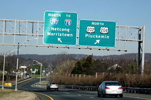
Somerville Circle
The Somerville Circle is a traffic circle located on the border of Bridgewater Township and Raritan, New Jersey, United States. The circle is at the intersection of U.S. Routes 202 and 206, and New Jersey Route 28...
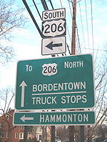
,where it meets US 202
U.S. Route 202 in New Jersey
U.S. Route 202 is a U.S. Highway running from New Castle, Delaware northeast to Bangor, Maine. In the U.S. state of New Jersey, the route runs from the New Hope-Lambertville Toll Bridge over the Delaware River at the Pennsylvania border in Delaware Township, Hunterdon County near Lambertville...
and Route 28. At this modified traffic circle, US 206 and Route 28 run through it while US 202 passes over it with ramp access. US 206 forms a concurrency with US 202 at this point and the two routes continue north into Bridgewater Township
Bridgewater Township, New Jersey
Bridgewater Township is a township in Somerset County, New Jersey, United States. , the township population was 44,464.Bridgewater Township was originally created by Royal Charter on April 4, 1749, from portions of the Northern precinct, and was incorporated as one of New Jersey's initial group of...
, briefly entering Somerville. The road features an interchange with US 22
U.S. Route 22 in New Jersey
U.S. Route 22 is a U.S. highway stretching from Cincinnati, Ohio in the west to Newark, New Jersey in the east. In New Jersey, the route runs for from the Easton-Phillipsburg Toll Bridge over the Delaware River in Phillipsburg, Warren County to Interstate 78 , US 1/9, and Route 21 at the Newark...
and heads north with the Bridgewater Commons
Bridgewater Commons
Bridgewater Commons is a fully enclosed mall located in Bridgewater Township, New Jersey. The mall is located at the intersection of U.S. Route 22 and U.S. Route 202/U.S. Route 206 and borders Interstate 287. The mall opened in 1989 and has a gross leasable area of...
shopping mall on the east side of the road and the Somerset Corporate Center on the west side of the road. An interchange with Commons Way provides access to both these places. Past Commons Way, the road passes under Garrettson Road and comes to an interchange with I-287
Interstate 287
Interstate 287 is an auxiliary Interstate Highway in the U.S. states of New Jersey and New York. It is a partial beltway around New York City, serving the northern half of New Jersey and the counties of Rockland and Westchester in New York...
that also provides access to I-78
Interstate 78 in New Jersey
Interstate 78 is an east–west route stretching from Union Township, Lebanon County, Pennsylvania to New York City. In New Jersey, I-78 is called the Phillipsburg–Newark Expressway and the Newark Bay Extension of the New Jersey Turnpike...
. Past the I-287 interchange, US 202/206 continue north as a two-lane undivided road past suburban areas. The road crosses Chambers Brook into Bedminster Township
Bedminster Township, New Jersey
Bedminster Township is a Township in Somerset County, New Jersey, United States. As of the 2010 United States Census, the township population was 8,165....
, where it soon passes under I-78. Shortly after I-78, it widens into a four-lane divided highway with a Jersey barrier
Jersey barrier
A Jersey barrier or Jersey wall is a modular concrete barrier employed to separate lanes of traffic. It is designed to both minimize vehicle damage in cases of incidental contact while still preventing crossover in the case of head-on accidents....
. US 202/206 come to another interchange with I-287, pass over the North Branch Raritan River
North Branch Raritan River
The North Branch Raritan River is a tributary of the Raritan River in central New Jersey in the United States.The North Branch Raritan River rises in central Morris County south of Dover and flows generally southward into Somerset County, around the southern end of the Watchung Mountains...
, and come to an intersection where the two routes split.
After the US 202 split, US 206 continues north as a four-lane divided highway through commercial areas, with the grass median becoming replaced by a painted median as it comes to a junction with CR 523
County Route 523 (New Jersey)
County Route 523 is a county highway in the U.S. state of New Jersey. The highway extends from Main Street in Stockton to Hillside Avenue in Bedminster Township.-Hunterdon County:...
in downtown Bedminster. Following this intersection, the route narrows into a two-lane undivided road that runs through less development. US 206 enters Peapack-Gladstone
Peapack-Gladstone, New Jersey
Peapack and Gladstone is a borough in Somerset County in the U.S. state of New Jersey. As of the 2010 Census, the borough population was 2,582...
, where it runs a short distance to the west of New Jersey Transit’s Gladstone Branch
Gladstone Branch
The Gladstone Branch is a branch of New Jersey Transit's Morris and Essex Lines. The Gladstone Branch primarily serves commuter trains; freight service is no longer operated...
. In Peapack-Gladstone, the road briefly becomes a four-lane divided highway as it has an interchange with Pfizer Way, a road that provides access to a Pfizer
Pfizer
Pfizer, Inc. is an American multinational pharmaceutical corporation. The company is based in New York City, New York with its research headquarters in Groton, Connecticut, United States...
facility. Past this point, US 206 becomes a two-lane undivided road that runs northwest through rural areas, with CR 512
County Route 512 (New Jersey)
County Route 512 is a county highway in the U.S. state of New Jersey. The highway extends from High Bridge Road in Califon to Springfield Avenue / Route 24 in Summit.-Hunterdon County:...
crossing the road. Just after this intersection, the route enters Bedminster Township again, turning to the north.
Morris County
The route continues north into Chester TownshipChester Township, New Jersey
Chester Township is a township in Morris County, New Jersey, United States. As of the 2010 United States Census, the township population was 7,838....
, Morris County
Morris County, New Jersey
Morris County is a county located in the U.S. state of New Jersey, about west of New York City. According to the United States 2010 Census, the population was 492,276. It is part of the New York Metropolitan Area. Its county seat is Morristown....
. In Chester Township, US 206 passes through forested areas, with the northbound direction briefly gaining a second lane. As the road comes into Chester Borough, it widens to four lanes and passes shopping areas including the Streets of Chester
Streets of Chester
The Streets of Chester is an outdoor shopping center located on U.S. Route 206 south in Chester Township, New Jersey. Streets of Chester features a diversity of upscale retailers such as Ann Taylor, Banana Republic, Coach Inc., J.Crew, Chico's, J. Jill, Talbot's and more. It opened in 2006 and is...
. In the center of Chester, the route crosses CR 513
County Route 513 (New Jersey)
County Route 513 is a county highway in the U.S. state of New Jersey. The highway extends from Kingwood Avenue in Frenchtown to Lakeside Road in West Milford...
. Past this intersection, US 206 continues into woodland development, with the northbound direction narrowing back into one lane as the route heads back into Chester Township. The road narrows back to two total lanes as it enters more rural surroundings, coming into Mount Olive Township
Mount Olive Township, New Jersey
-Transportation:The major roads that pass through include U.S. Route 46 through the center, U.S. Route 206 in the east and northeast part and Interstate 80 in the north .-Demographics:As of the census of 2000, there were 24,193 people, 9,068 households, and 6,374 families residing in the...
. Further north, residential development near the road starts to increase. As US 206 reaches an intersection with CR 613, the surroundings becomes commercial before the route passes under an abandoned railroad line. After this area, the road turns north-northeast and runs through forested areas as a three lane road with two northbound lanes and one southbound lane, eventually entering Roxbury Township
Roxbury Township, New Jersey
-Demographics:As of the census of 2000, there were 23,883 people, 8,364 households, and 6,532 families residing in the township. The population density was 1,117.4 people per square mile . There were 8,550 housing units at an average density of 400.0 per square mile...
.
Business in the area of the road increase before US 206 widens to four total lanes and comes to a modified cloverleaf interchange
Cloverleaf interchange
A cloverleaf interchange is a two-level interchange in which left turns, reverse direction in left-driving regions, are handled by ramp roads...
with I-80
Interstate 80 in New Jersey
Interstate 80 is a major Interstate Highway in the United States, running from the New York City Metropolitan Area westward to San Francisco, California...
and the southern terminus of Route 183
New Jersey Route 183
Route 183 is a long state highway in the northern regions of New Jersey. The southern end of NJ 183 is at an interchange with Interstate 80 and U.S. Route 206 near Netcong, while the northern end is at an interchange with US 206 in Stanhope. The route heads northward through downtown Netcong and...
. At this point, the road continues north into Netcong
Netcong, New Jersey
Netcong is a Borough in Morris County, New Jersey, United States. As of the United States 2000 Census, the borough population was 2,580. Its estimated population in 2006 was 3,292...
as Route 183 while US 206 heads west along I-80, a six-lane freeway that continues into Mount Olive Township. The freeway continues northwest, running through a small corner of Netcong before coming back into Mount Olive Township and interchanging with US 46
U.S. Route 46
U.S. Route 46 is an east–west U.S. Highway, running for , completely within the state of New Jersey. The west end is at an interchange with Interstate 80 and Route 94 in Columbia, Warren County on the Delaware River...
. Immediately after US 46, the highway passes over New Jersey Transit’s Morristown Line
Morristown Line
The Morristown Line is one of New Jersey Transit's commuter lines and is one of two branches that run along the Morris and Essex Lines. Out of 60 inbound and 58 outbound daily weekday trains, 28 inbound and 26 outbound trains use the Kearny Connection to Secaucus Junction and New York Penn...
/Montclair-Boonton Line
Montclair-Boonton Line
The Montclair-Boonton Line is a commuter rail line of New Jersey Transit Rail Operations. It is part of the Hoboken Division. The line is a consolidation of three individual lines: the former Delaware, Lackawanna & Western Railroad's Montclair Branch, which ran from Hoboken Terminal to Bay Street,...
before turning north and reaching a trumpet interchange where US 206 splits from I-80. Following this split, US 206 is a four-lane freeway that heads northeast, crossing under Waterloo Valley Road and an abandoned railroad line before coming to an interchange with International Drive.
Sussex County
After the International Drive interchange, US 206 crosses the Musconetcong RiverMusconetcong River
The Musconetcong River is a tributary of the Delaware River in northwestern New Jersey in the United States. It flows through the rural mountainous country of northwestern New Jersey. Part of it is a National Wild and Scenic River....
and enters Stanhope
Stanhope, New Jersey
-Transportation:Route 183 is the main access road that serves the borough. U.S. Route 206 also passes through in the western section and is partially a limited access road which connects to I-80 in neighboring Mount Olive.-Demographics:...
, Sussex County
Sussex County, New Jersey
The County of Sussex is the northernmost county in the State of New Jersey. It is part of the New York City Metropolitan Area. As of the 2010 Federal decennial census, 149,265 persons resided in Sussex County...
. Immediately following the river crossing, the freeway merges with the northern terminus of Route 183 at an interchange on the border between Byram Township
Byram Township, New Jersey
Byram Township — "The Township of Lakes" — is a Township in Sussex County, New Jersey, United States. As of the 2010 United States Census, the township population was 8,350...
to the west and Stanhope to the east. Past Route 183, US 206 continues north as a four-lane divided surface road past development, fully entering Stanhope again before crossing into Byram Township. Upon entering Byram Township, the route becomes a two-lane undivided road. Upon turning northwest, the surroundings become more forested as US 206 crosses a mountain, with the northbound direction gaining a second lane for a distance. There are a few businesses along the road as it runs north past wooded areas near Cranberry Lake and Panther Lake. The route continues into Andover
Andover, New Jersey
Andover is a Borough in Sussex County, New Jersey, United States. As of the 2010 United States Census, the borough population was 606.Andover was incorporated as a borough by an Act of the New Jersey Legislature on March 25, 1904, from portions of Andover Township.-Geography:Andover is located at ...
, where it becomes Main Street and passes under the abandoned Lackawanna Cut-Off. US 206 forms a brief concurrency with CR 517
County Route 517 (New Jersey)
County Route 517 is a county highway in the U.S. state of New Jersey. The highway extends from Lamington Road in Tewksbury Township to the New York state line in Vernon Township where it continues as Orange County Route 26. It mainly traverses through small, rural communities and unincorporated...
in the commercial downtown area. Past CR 517, US 206 bends northwest and enters Andover Township
Andover Township, New Jersey
Andover Township is a Township in Sussex County, New Jersey, United States. As of the 2010 United States Census, the township population was 6,319....
. Here, the road runs back into forested areas, passing by Whites Pond and running near Kittatinny Valley State Park
Kittatinny Valley State Park
Kittatinny Valley State Park is located near Andover, New Jersey. Glacial lakes, limestone outcroppings, former railroads, and a small airport are just some of the features of the park. Lake Aeroflex and Gardner's Pond form part of the headwaters of the Pequest River and are excellent for fishing...
. After a curve to the north, the route enters a mix of development and rural areas, passing to the west of Newton Airport
Newton Airport (New Jersey)
Newton Airport is a privately-owned, public-use airport located three nautical miles south of the central business district of the town of Newton, in Sussex County, New Jersey, United States.- Facilities and aircraft :...
prior to entering Newton
Newton, New Jersey
Newton is a town in Sussex County, New Jersey, United States. As of the United States 2000 Census, the town population was 8,244. It is the county seat of Sussex County....
.
In Newton, the road is known as Main Street and is lined by homes as it turns north. Upon reaching the downtown area, US 206 meets Route 94 and CR 519
County Route 519 (New Jersey)
County Route 519 is a county highway in the U.S. state of New Jersey. The highway extends from Daniel Bray Highway in Delaware Township to the New York state line in Wantage Township...
at the Park Place square. At this point, US 206 forms a concurrency with Route 94/CR 519, and all three routes run concurrent north on four-lane undivided Water Street for a short distance. CR 519 splits from the road by turning north on Mill Street while US 206 and Route 94 continue north as a three-lane road with a center left-turn lane, crossing Paulins Kill
Paulins Kill
The Paulins Kill is a tributary of the Delaware River in northwestern New Jersey in the United States...
before coming to a shopping district as the road leaves Newton for Hampton Township
Hampton Township, New Jersey
Hampton Township is a Township in Sussex County, New Jersey, United States. As of the 2000 United States Census, the township population was 4,943....
. The road narrows back to two lanes and heads into areas of farmland, becoming Hampton House Road. Route 94 splits from US 206 by making a right turn to continue east. After this intersection, US 206 turns northeast and enters Frankford Township
Frankford Township, New Jersey
Frankford Township is a Township in Sussex County, New Jersey, United States. As of the 2010 United States Census, the township population was 5,565....
. After crossing the Paulins Kill, Route 15 and CR 565
County Route 565 (New Jersey)
County Route 565, abbreviated CR 565, is a county highway in the U.S. state of New Jersey. The highway extends from U.S. Route 206 / Route 15 in Frankford Township to McAfee Glenwood Road in Vernon Township.-Route description:...
end at a traffic light with US 206, with the route making a turn to the northwest on an unnamed road.
After this intersection, the route passes near Skylands Park
Skylands Park
CenturyLink Field at Skylands Park is a baseball stadium located in Augusta, New Jersey. Skylands Park opened in 1994 and was built for the New Jersey Cardinals, the New York-Penn League affiliate for the St. Louis Cardinals. The Cardinals called the park home until 2005, after which the team was...
before passing more farmland and reaching the community of Augusta
Augusta, New Jersey
Augusta is an unincorporated area located within Frankford Township, Sussex County, New Jersey.Augusta is the home of the New Jersey State Fair and the Sussex County Farm and Horse Show....
. After Augusta, US 206 turns north-northwest through more rural areas before entering Branchville
Branchville, New Jersey
Branchville is a borough in Sussex County, New Jersey, in the United States. As of the 2010 United States Census, the borough population was 841. The borough is located in the northernmost region of Sussex County....
. Here, the route bypasses the center of town to the south as a four-lane divided highway before crossing CR 519. Past CR 519, the median ends and US 206 continues to the west-northwest. After crossing back into Frankford Township, the route continues through forested areas. Turning more to the north, US 206 runs a short distance to the west of Culvers Lake prior to intersecting CR 521
County Route 521 (New Jersey)
County Route 521 is a county highway in the U.S. state of New Jersey. The highway extends 43.71 miles from High Street in Hope Township to the New York state line in Montague Township....
and forming a concurrency with that route. The concurrent US 206 and CR 521 crosses into Sandyston Township
Sandyston Township, New Jersey
- Local government :Sandyston Township is governed under the Township form of government with a three-member Township Committee. The Township Committee is elected directly by the voters in partisan elections to serve three-year terms of office on a staggered basis, with one seat coming up for...
, where it passes through the mountainous Stokes State Forest
Stokes State Forest
Stokes State Forest is a state park located in Sandyston Township, Montague and Frankford Twp. in Sussex County, New Jersey, United States. Stokes comprises of mountainous woods...
. After heading north with a three-lane stretch that has two southbound lanes and one northbound lane, the two-lane road reaches a junction with CR 560
County Route 560 (New Jersey)
County Route 560 is a county highway in the U.S. state of New Jersey. The highway extends from U.S. Route 206 and County Route 521 in Sandyston Township. Route 560 ends at the Pennsylvania state line, where it becomes Pike County Quadrant Route 2019, which connects to Pennsylvania Route 739...
. After this intersection, the road leaves the state forest and continues through wooded areas with some commercial establishments. US 206/CR 521 reaches the community of Hainesville
Hainesville, New Jersey
The town of Hainesville is an unincorporated community located within Sandyston Township, New Jersey. It lies along a stretch of County Route 645, known as the Layton-Hainesville Road, that runs parallel to U.S. Route 206 and connects to County Route 675. It is adjacent to the Delaware Water Gap...
, where it passes through more agricultural surroundings with some development. Leaving Hainesville, the road continues into Montague Township
Montague Township, New Jersey
-Transportation:One U.S., state, and county route traverse the township. U.S. Route 206 passes through in the western part and crosses the Delaware River at the Milford-Montague Toll Bridge. Route 23 passes through the eastern part and serves as the entrance road to High Point State Park and ends...
. Near the community of Montague, CR 521 splits from US 206 by heading to the northeast. Meanwhile, US 206 turns to the northwest to run through wooded areas of the Delaware Water Gap National Recreation Area
Delaware Water Gap National Recreation Area
Delaware Water Gap National Recreation Area, administered by the National Park Service, preserves almost of land along the Delaware River's New Jersey and Pennsylvania shores, stretching from the Delaware Water Gap northward almost to the New York state line...
, where it comes to the Milford-Montague Toll Bridge
Milford-Montague Toll Bridge
The Milford–Montague Toll Bridge is a truss bridge crossing the Delaware River, connecting Montague Township, New Jersey to Milford, Pennsylvania on U.S. Route 206. The two-lane bridge, which opened on December 30, 1953, has a total length of 1,150 feet , and is operated by the Delaware River...
over the Delaware River
Delaware River
The Delaware River is a major river on the Atlantic coast of the United States.A Dutch expedition led by Henry Hudson in 1609 first mapped the river. The river was christened the South River in the New Netherland colony that followed, in contrast to the North River, as the Hudson River was then...
that is maintained by the Delaware River Joint Toll Bridge Commission
Delaware River Joint Toll Bridge Commission
The Delaware River Joint Toll Bridge Commission is a bistate, public agency charged with providing safe, dependable and efficient river crossings between Pennsylvania and New Jersey. The DRJTBC was established under legislation enacted in the two states in 1934. The federal Compact for the...
.
Pennsylvania
After crossing the river on the Milford-Montague Toll Bridge, US 206 continues north into Dingman Township in Pike County, PennsylvaniaPike County, Pennsylvania
-National protected areas:* Delaware Water Gap National Recreation Area * Middle Delaware National Scenic River * Upper Delaware Scenic and Recreational River -Demographics:...
. A short distance after the bridge, the route comes to a northbound toll plaza, where it becomes a two-lane divided highway. US 206 officially ends at an intersection with US 209 not far after the toll plaza for the bridge. Even though this intersection marks the end of US 206, a few signs show the route heading concurrent with US 209 to continue north to US 6
U.S. Route 6 in Pennsylvania
U.S. Route 6 travels east–west near the north edge of the U.S. state of Pennsylvania from the Ohio state line near Pymatuning Reservoir east to the Mid-Delaware Bridge over the Delaware River into Port Jervis, New York. It is the longest highway segment in the Commonwealth. Most of it is a...
in Milford
Milford, Pennsylvania
Milford is a borough in Pike County, Pennsylvania, United States, and the county seat. Its population was 1,021 at the 2010 census. It was founded in 1796 by Judge John Biddis, one of the state's first four circuit judges, who named the settlement after his ancestral home in Wales.Milford has a...
.
History
Prior to 1927, what is now US 206 in New Jersey was legislated as part of several routes. Between Bordentown and Trenton, the current alignment was designated as a part of pre-1927 Route 2 in 1916. Between Trenton and Princeton, present-day US 206 became the southernmost part of pre-1927 Route 13 in 1917. In 1921, the current route from Princeton north to Bedminster Township was legislated as part of pre-1927 Route 16. After the U.S. Highway System was created in 1926, the route between Bordentown and Trenton became the northernmost part of US 130 while it became a part of US 1 between Trenton and Princeton. In the 1927 New Jersey state highway renumbering1927 New Jersey state highway renumbering
In 1927, New Jersey's state highways were renumbered. The old system, which had been defined in sequence by the legislature, was growing badly, as several routes shared the same number, and many unnumbered state highways had been defined...
, several state highways were legislated along present-day US 206. Route 39 followed the route from Hammonton to White Horse, while Route 37 was designated along it between White Horse and Trenton. From Trenton north to Princeton, pre-1927 Route 13 was replaced by Route 27. Present-day US 206 between Princeton and Newton became part of Route 31, a route that was to go past Newton to the New York border near Unionville, while the portion north of Newton to the Delaware River in Montague became Route S31, a spur of Route 31. Another spur of Route 31, Route 31A, was legislated in 1941 to run from Route 31 in Princeton to Route 33 in Hightstown
Hightstown, New Jersey
Hightstown is a Borough in Mercer County, New Jersey, United States. As of the 2010 United States Census, the borough population was 5,494.Hightstown was incorporated as a borough by an Act of the New Jersey Legislature on March 5, 1853, within portions of East Windsor Township. The borough became...
; only a small portion of this was built over the Northeast Corridor railroad line and is now Route 64.
US 206 was designated in the later 1930s, running from US 30 in Hammonton, New Jersey north to US 6 and US 209 in Milford, Pennsylvania. By this time, the US 1 and US 130 designations were removed from the route onto new alignments. In 1938, US 206/Route 31 was designated to bypass Somerville, the former alignment was known as Route 177
New Jersey Route 177
Route 177 was the shortest state highway recorded in Somerset County, New Jersey and the second shortest around the entire state of New Jersey . Route 177 went for a short, state-maintained portion of Bridge Street in Somerville...
from the 1960s until 1974. In the 1940s, US 206/Route 39 was realigned to the south of White Horse; the former alignment was known as Route 160
New Jersey Route 160
Route 160 was a short, long state highway in Burlington County, New Jersey. The highway ran along a former alignment of New Jersey Route 39 and U.S. Route 206 called Mission Road in Bordentown Township. The route began at an intersection with U.S. Route 206, paralleling the four-lane highway to...
between the 1960s and the 1980s. Also in the 1940s, the northern terminus of US 206 was moved to its current location at US 209 in Dingman Township, Pennsylvania.
In the 1953 New Jersey state highway renumbering
1953 New Jersey state highway renumbering
On January 1, 1953, the New Jersey Department of Transportation renumbered many of the State Routes. A few rules were followed in deciding what to renumber:...
, the state highways running concurrent with US 206 were removed. When US 206's current alignment bypassing Columbus was built by the 1960s, the designation of Route 170
New Jersey Route 170
Route 170 was a short, long state highway in Burlington County, New Jersey. The route was a former alignment of U.S. Route 206 and New Jersey Route 39 in the downtown portions of Mansfield Township and Columbus. Route 170 began at an intersection with U.S. Route 206 in Mansfield Township, headed...
was given to the old alignment through Columbus; this road was turned over to Burlington County in the 1980s and is now CR 690. In the late 1960s, a freeway was proposed for the US 206/Route 54 corridor, running from US 30 in Hammonton south to Route 55 and the proposed Route 60 near Vineland
Vineland, New Jersey
Vineland is a city in Cumberland County, New Jersey, United States. As of the 2010 United States Census, the city had a total population of 60,724...
and Millville
Millville, New Jersey
Millville is a city in Cumberland County, New Jersey, United States. As of the 2000 United States Census, the city population was 26,847. Millville, Bridgeton and Vineland are the three principal New Jersey cities of the Vineland-Millville-Bridgeton Primary Metropolitan Statistical Area which...
. Originally, a parkway
Parkway
The term parkway has several distinct principal meanings and numerous synonyms around the world, for either a type of landscaped area or a type of road.Type of landscaped area:...
had been planned in 1932 to serve the US 206 corridor between Hammonton and Trenton, but never materialized. The freeway between Vineland/Millville and Hammonton was to cost $47 million and was intended to provide a better route between the two areas than the existing two-lane roads. However, it was never built due to environmental and financial issues. A freeway was also proposed for US 206 in northwestern New Jersey during the 1960s. In 1964, a Route 94 freeway was planned to follow US 206 between Netcong and Newton on its way to the proposed Route 23 freeway in Hamburg
Hamburg, New Jersey
Hamburg is a Borough in Sussex County, New Jersey, United States. As of the United States 2010 Census, the borough population was 3,277.In 1753, when Sussex County was formed, Hamburg was part of New Town; on February 25, 1762, it became part of the newly established Hardyston Township...
. The Tri-State Transportation Commission proposed a longer US 206 freeway that was to connect I-78 and I-287 in Bedminster Township north to Newton, incorporating the southern portion of the Route 94 proposal. This freeway was intended to relieve traffic on existing roads and provide access to recreation areas. By the late 1960s, the US 206 freeway would be planned by the NJDOT to connect I-80 in Netcong north to Montague. This freeway was proposed to provide access to Tocks Island
Tocks Island
Tocks Island, located upstream from Delaware Water Gap in the Delaware River was the controversial site of a dam, proposed in the 1950s, which would have created a 37-mile long lake between Pennsylvania and New Jersey, with depths of up to 140 feet...
as well as alleviating traffic on the existing road. However, like the US 206 freeway proposal in southern New Jersey, it was not built.
Since 1974, a bypass has been planned for the congested part of US 206 through Hillsborough. In 2002, the NJDOT modified plans for the bypass. The bypass is to be mostly four lanes wide and run to the east of Hillsborough, with the southernmost portion only being two lanes; one interchange was planned with CR 514. The road is to meet a Smart Growth goal by preserving land and eliminating two planned interchanges that would have increased congestion. In July 2009, it was announced that construction of the US 206 Hillsborough bypass, which is projected to cost $148 million, would start in 2010. On June 24, 2010, a contract was given to Carbro Constructors Corporation to build the first phase between CR 514 and Hillsborough Road. Construction on this portion, planned to cost $43 million, began on August 18, 2010 with completion planned for 2012. The remaining segments are planned to be bid on in 2012 with the entire bypass completed in 2015.
US 206 is currently being widened in Byram Township to six lanes, with completion expected in 2011. This construction follows a decade of controversy, including concerns that the widening would violate the Highlands Water Protection and Planning Act
Highlands Water Protection and Planning Act
The Highlands Water Protection and Planning Act is a 2004 New Jersey law aimed at protecting the Highlands region of northwest New Jersey by regulating development within the region under the supervision of the New Jersey Department of Environmental Protection. The Highland region covers , nearly...
passed in 2004; an exemption to this act allowed the construction to proceed. The widening is being done in order to eliminate backups on the current two-lane stretch during rush hours.
Major intersections
|-|rowspan=2|Roxbury Township
Roxbury Township, New Jersey
-Demographics:As of the census of 2000, there were 23,883 people, 8,364 households, and 6,532 families residing in the township. The population density was 1,117.4 people per square mile . There were 8,550 housing units at an average density of 400.0 per square mile...
|colspan=5 align="center"|South end of freeway
|-
|-
|colspan=5 align="center"|North end of freeway
|-
|-
|rowspan=2|129.77
|rowspan=2 colspan=2 align="center"|Milford-Montague Toll Bridge
Milford-Montague Toll Bridge
The Milford–Montague Toll Bridge is a truss bridge crossing the Delaware River, connecting Montague Township, New Jersey to Milford, Pennsylvania on U.S. Route 206. The two-lane bridge, which opened on December 30, 1953, has a total length of 1,150 feet , and is operated by the Delaware River...
over Delaware River
Delaware River
The Delaware River is a major river on the Atlantic coast of the United States.A Dutch expedition led by Henry Hudson in 1609 first mapped the river. The river was christened the South River in the New Netherland colony that followed, in contrast to the North River, as the Hudson River was then...
New Jersey
New Jersey
New Jersey is a state in the Northeastern and Middle Atlantic regions of the United States. , its population was 8,791,894. It is bordered on the north and east by the state of New York, on the southeast and south by the Atlantic Ocean, on the west by Pennsylvania and on the southwest by Delaware...
– Pennsylvania
Pennsylvania
The Commonwealth of Pennsylvania is a U.S. state that is located in the Northeastern and Mid-Atlantic regions of the United States. The state borders Delaware and Maryland to the south, West Virginia to the southwest, Ohio to the west, New York and Ontario, Canada, to the north, and New Jersey to...
state line
|-
|rowspan=2|Pike
Pike County, Pennsylvania
-National protected areas:* Delaware Water Gap National Recreation Area * Middle Delaware National Scenic River * Upper Delaware Scenic and Recreational River -Demographics:...
|rowspan=2|Dingman Township
Dingman Township, Pennsylvania
Dingman Township is a township in Pike County, Pennsylvania, United States. The population was 11,926 at the 2010 census. The Township was created in 1832 and named in honor of Judge Daniel Westbrook Dingman.-Geography:...
External links
- An enlarged view of road jurisdiction in Trenton at the confluence of US 1, US 206, NJ 29, NJ 33 and NJ 129
- An enlarged view of road jurisdiction at the confluence of I-80, US 46, US 206 and NJ 183 in and near Roxbury Township
- An enlarged view of road jurisdiction at the confluence of US 206, NJ 94 and CR 519 in Newton
- New Jersey Roads: U.S. Route 206
- Endpoints of US highways
- Somerset County Functional Classification Map
- Speed Limits for New Jersey State Roads: U.S. Route 206 in New Jersey