

U.S. Route 44
Encyclopedia
U.S. Route 44 is an east–west United States highway that runs for 237 miles (381 km) through four states in the Northeastern
region of the United States
. The western terminus is at U.S. Route 209
and New York State Route 55
in Kerhonkson
, a hamlet in the Hudson Valley
region of New York
. The eastern terminus is at Route 3A in Plymouth, Massachusetts.
|NY
|| 65.98 || 106.18
|-
|CT
|| 106.03 || 170.64
|-
|RI || 26.3 || 42.3
|-
|MA || 38.40 || 61.80
|-
|Total || 236.7 || 380.9
|}
. Route 44 is about 66 miles (106.2 km) long in the state, progressing through Ulster and Dutchess Counties. The route crosses into Connecticut after intersecting with New York State Route 22
in Millerton
.
to the Rhode Island state line at Putnam
, US 44 runs for a total of 106.03 miles (170.6 km) in Connecticut
. Most of US 44 is known in the state as the Jonathan Trumbull
Highway. It begins as rural arterial road in Litchfield county
, going through the towns of North Canaan, Norfolk, Colebrook, Winchester, Barkhamsted, and New Hartford. It is a 2-lane road with 4-lane sections in Winchester
.
In Canton
, US 44 is joined by US 202
and becomes a mostly 4-lane principal arterial road serving the Hartford metro area
. US 44 continues through Simsbury, Avon
, and West Hartford. US 202 splits from US 44 in Avon following the route of Route 10 after overlapping for 5.3 miles (8.5 km). US 44 then enters the city of Hartford
along Albany Avenue, then goes up onto I-84
/US 6
to cross the Connecticut River
on the Bulkeley Bridge
. In East Hartford
, US 44 then returns to surface roads right after crossing the river. It becomes a 2-lane minor arterial road through Manchester, Bolton, Coventry, and Mansfield, then becomes a rural road through Willington, Ashford, Eastford, Pomfret, and Putnam
. In Manchester
, US 44 overlaps with US 6 for 6.9 miles (11.1 km) up to Bolton
until just after the eastern terminus of I-384
. This segment of US 44 up to Willington is known as the Boston Turnpike while the segment approaching Rhode Island is called Providence Pike.
 US 44 runs 26.2 miles (42.2 km) in Rhode Island
. During this part of the road, Route 44 is often referred to locally as "Putnam Pike" as the road runs through Rhode Island and into Putnam, Connecticut
. US 44 enters the state at Glocester
, traveling for several miles in between several reservoirs of the Providence area as it heads towards the village of Greenville
in the town of Smithfield
. US 44 has a junction with I-295 in Smithfield at a cloverleaf interchange
. Soon after the I-295 junction, US 44 enters the city of North Providence
along Smith Street, then enters the city proper of Providence
after another 1.7 miles (2.7 km). In downtown Providence, US 44 separates into one-way couplets. Eastbound US 44 runs along Canal Street and South Water Street (via a section of Memorial Boulevard). Westbound US 44 runs along South Main Street and North Main Street. US 44 joins I-195/US 6 at Exit 2 as they cross the Seekonk River
into East Providence
. US 44 leaves I-195/US 6 at Exit 4 just after crossing the river and continues east towards the Massachusetts state line along Taunton Avenue.
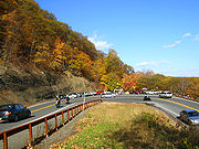
 US 44 runs for 38.4 miles (61.8 km) in Massachusetts. It enters the state in the town of Seekonk
along Taunton Avenue. It goes to the city of Taunton
passing through the towns of Rehoboth
and Dighton
along the way. It continues eastward from Taunton through the towns of Raynham
, Lakeville
, Middleborough
, Carver
, Plympton
and Kingston
before reaching its eastern terminus at Plymouth. US 44 has interchanges with Route 24
in Raynham and with Interstate 495
in Middleborough. East of the Middleborough Rotary, US 44 becomes an arterial highway for five miles (8 km) until just past the intersection with Route 105, where it turns into a two-lane freeway
with a guard rail
acting as a median divider for three miles (5 km) until just before the intersection with Route 58. After that, it becomes a newly-built, 7.5 miles (12.1 km) long freeway section to Route 3
which bypasses the congested business district in Plymouth. (The old section of US 44 appeared on some maps starting in 2005 as Route 44A; however, Route 44A signs were not put up after the bypass was built, and the route has not appeared in the official route log of the Massachusetts Department of Transportation.) Near its eastern terminus, Route 44 overlaps Route 3
for about 1 miles (1.6 km), then exits and continues as a surface road for approximately another half mile, ending at Route 3A.
In Middleborough
, Route 44 passes by the historically significant Oliver Mill Park, site of Judge Peter Oliver's 18th-century industrial complex. Ancient stone-walled waterways still remain here on the banks of the Nemasket River
.
in the state during the 19th century. From the New York state line at Salisbury to the village of Lakeville, the route was the westernmost section of the Salisbury and Canaan Turnpike. Between North Canaan and New Hartford, modern US 44 was known as the Greenwoods Turnpike. The southeastward continuation of the Greenwoods road to the West Hartford-Hartford line was known as the Talcott Mountain Turnpike. From East Hartford to Eastford, the Boston Turnpike was chartered mostly along modern US 44 as the direct route from Hartford to Boston. The Boston Turnpike differed from modern US 44 by using a more direct route between Eastford and Pomfret Center along modern Route 244, while US 44 runs via the village of Abington. Past Pomfret Center, the Boston Turnpike diverged from modern US 44 heading northeast across the town of Thompson. The route through Putnam to the Rhode Island state line was a different turnpike road known as the Pomfret and Killingly Turnpike.
In 1922, the New England states designated route numbers on its main roads. Route 101 was assigned as the route used by the Pomfret and Killingly Turnpike (modern US 44) to Pomfret Center, then modern US 44 to Phoenixville via Abington (short portions of two other turnpike roads), then a road southward from Phoenixville to South Chaplin (modern Route 198), ending at New England Route 3. The direct road connecting Phoenixville to Bolton Notch was designated as Route 109. From Hartford to Bolton Notch, modern US 44 was at the time known as New England Route 3. West of Hartford, modern US 44 was designated as part of New England Route 17, which stretched in Connecticut from North Canaan to Stonington (via modern Route 2). Between the New York state line at Salisbury and North Canaan, the road was known as Route 121.
In 1926, most of New England Route 3 became U.S. Route 6. In the 1932 state highway renumbering
, New England Route 17 was broken up into two newly assigned routes: modern Route 2 east of Hartford, and part of Route 101 west of Hartford. Route 101 was reconfigured in 1932 from its 1920s alignment to continue west of Phoenixville along former Route 109, then overlapping with US 6 to Hartford. Route 101 then used the western half of former New England Route 17 to North Canaan where it ended. The road from North Canaan to Salisbury was renumbered in 1932 to Route 199 to match the route number in New York at the time. In 1935, US 44 was designated and utilized Route 101 across the states of Connecticut, Rhode Island, and Massachusetts. Route 199 was also incorporated into the new route, connecting with the New York state line.
In the 1940s, US 44 was relocated along a portion of the Wilbur Cross Highway
for several years with the former surface alignment becoming US 44A. The change was later reversed. US 6 was also relocated in East Hartford and Manchester to use I-84 and the overlap between US 6 and US 44 is now only between Manchester and Bolton Notch.
In 1922, when the New England states first assigned route numbers to its main thoroughfares, the route from Putnam through Providence and Taunton to Plymouth was designated as Route 101. Route 101 extended across Rhode Island and Massachusetts along modern US 44, with an extension into Connecticut along an alignment different from US 44. In 1932, Connecticut relocated its Route 101 to the modern US 44 alignment, with the route now extending across the three states from North Canaan in Connecticut to Plymouth in Massachusetts. In 1935, the multi-state Route 101 was incorporated into newly-designated US 44. Connecticut and Rhode Island reassigned the Route 101 designation to a much shorter but parallel alignment between the two states.
On 14 December 2005, a freeway realignment opened to the north of the original surface alignment US 44 in the towns of Carver and Plymouth. US 44 was rerouted onto the new expressway and now runs concurrent with Route 3
from the latter freeway's exit 7, where the new freeway ends, south to exit 6, where US 44 rejoins its former alignment.

.
Northeastern United States
The Northeastern United States is a region of the United States as defined by the United States Census Bureau.-Composition:The region comprises nine states: the New England states of Connecticut, Maine, Massachusetts, New Hampshire, Rhode Island and Vermont; and the Mid-Atlantic states of New...
region of the United States
United States
The United States of America is a federal constitutional republic comprising fifty states and a federal district...
. The western terminus is at U.S. Route 209
U.S. Route 209
U.S. Route 209 is a long U.S. highway in the states of Pennsylvania and New York. Although the route is a spur of U.S. Route 9, US 209 never intersects US 9, making the connection via U.S. Route 9W instead. The southern terminus of the route is at Pennsylvania...
and New York State Route 55
New York State Route 55
New York State Route 55 is a state highway in southern New York, running from the Pennsylvania state line at the Delaware River in Barryville to the Connecticut state line at Wingdale...
in Kerhonkson
Kerhonkson, New York
Kerhonkson is a hamlet in Ulster County, New York, United States. The population was 1,684 at the 2010 census.Kerhonkson is a small hamlet which, along with Accord, makes up the Town of Rochester on US 209, just south of the town's boundary with the Town of Wawarsing and just north of where US 44...
, a hamlet in the Hudson Valley
Hudson Valley
The Hudson Valley comprises the valley of the Hudson River and its adjacent communities in New York State, United States, from northern Westchester County northward to the cities of Albany and Troy.-History:...
region of New York
New York
New York is a state in the Northeastern region of the United States. It is the nation's third most populous state. New York is bordered by New Jersey and Pennsylvania to the south, and by Connecticut, Massachusetts and Vermont to the east...
. The eastern terminus is at Route 3A in Plymouth, Massachusetts.
Route description
|-|NY
U.S. Route 44 in New York
U.S. Route 44 in the state of New York is a major east–west thoroughfare in the Hudson Valley region of the state. Its entire length is maintained by the New York State Department of Transportation, with the exception of the Mid-Hudson Bridge, which is maintained by the New York State Bridge...
|| 65.98 || 106.18
|-
|CT
U.S. Route 44 in Connecticut
U.S. Route 44 is an east–west U.S. Highway running from Salisbury to Putnam.-Route description:From the New York state line at Salisbury to the Rhode Island state line at Putnam, US 44 runs for a total of in Connecticut. Most of US 44 is known in the state as the Jonathan Trumbull Highway...
|| 106.03 || 170.64
|-
|RI || 26.3 || 42.3
|-
|MA || 38.40 || 61.80
|-
|Total || 236.7 || 380.9
|}
New York
US 44 begins at US 209/NY 55 in the hamlet of Kerhonkson in Ulster CountyUlster County, New York
Ulster County is a county located in the state of New York, USA. It sits in the state's Mid-Hudson Region of the Hudson Valley. As of the 2010 census, the population was 182,493. Recent population estimates completed by the United States Census Bureau for the 12-month period ending July 1 are at...
. Route 44 is about 66 miles (106.2 km) long in the state, progressing through Ulster and Dutchess Counties. The route crosses into Connecticut after intersecting with New York State Route 22
New York State Route 22
New York State Route 22 is a north–south state highway in eastern New York in the United States. It runs parallel to the state's eastern edge from the outskirts of New York City to a short distance south of the Canadian border. At , it is the state's longest north–south route and...
in Millerton
Millerton, New York
Millerton is a village in Dutchess County, New York, United States. The population was 925 at the 2000 census. It is part of the Poughkeepsie–Newburgh–Middletown, NY Metropolitan Statistical Area as well as the larger New York–Newark–Bridgeport, NY-NJ-CT-PA Combined...
.
Connecticut
From the New York state line at SalisburySalisbury, Connecticut
Salisbury is a town in Litchfield County, Connecticut, United States. The town is the northwest-most in the State of Connecticut. The MA-NY-CT Tri-State Marker is located just on the border of Salisbury...
to the Rhode Island state line at Putnam
Putnam, Connecticut
Putnam is a town in Windham County, Connecticut, United States. The population was 9,002 as of the 2000 census. It is home to WINY, an AM radio station.-History:...
, US 44 runs for a total of 106.03 miles (170.6 km) in Connecticut
Connecticut
Connecticut is a state in the New England region of the northeastern United States. It is bordered by Rhode Island to the east, Massachusetts to the north, and the state of New York to the west and the south .Connecticut is named for the Connecticut River, the major U.S. river that approximately...
. Most of US 44 is known in the state as the Jonathan Trumbull
Jonathan Trumbull
Jonathan Trumbull, Sr. was one of the few Americans who served as governor in both a pre-Revolutionary colony and a post-Revolutionary state...
Highway. It begins as rural arterial road in Litchfield county
Litchfield County, Connecticut
Litchfield County is a county located in the northwestern corner of the U.S. state of Connecticut. Litchfield County has the lowest population density of any county in Connecticut but is geographically the state's largest county. As of 2010 the population was 189,927...
, going through the towns of North Canaan, Norfolk, Colebrook, Winchester, Barkhamsted, and New Hartford. It is a 2-lane road with 4-lane sections in Winchester
Winchester, Connecticut
Winchester is a town in Litchfield County, Connecticut, United States. The population was 10,664 at the 2000 census. The Incorporated City of Winsted is located in Winchester.-Geography:...
.
In Canton
Canton, Connecticut
Canton is a rural town, incorporated in 1806, in Hartford County, Connecticut. The population was 8,840 at the 2000 census, and has grown to 10,292 as of the 2010 census. It is bordered by Granby on the north, Simsbury on the east, Avon and Burlington on the south, New Hartford on the west, and...
, US 44 is joined by US 202
U.S. Route 202
U.S. Route 202 is a highway stretching from Delaware to Maine, also passing through the states of Pennsylvania, New Jersey, New York, Connecticut, Massachusetts, and New Hampshire....
and becomes a mostly 4-lane principal arterial road serving the Hartford metro area
Greater Hartford
Greater Hartford is a region located in the state of Connecticut, centered on the state's capital of Hartford.Hartford's role as a focal point for the American insurance industry is known nationally. The vibrant music and arts scene defines the region's culture...
. US 44 continues through Simsbury, Avon
Avon, Connecticut
Avon is a town in the Farmington Valley region of Hartford County, Connecticut, United States. , the town had a population of 18,098.Avon is a suburb of Hartford. Avon Old Farms School, a prestigious boarding school, is located there. In 2005, Avon was named the third-safest town in America by...
, and West Hartford. US 202 splits from US 44 in Avon following the route of Route 10 after overlapping for 5.3 miles (8.5 km). US 44 then enters the city of Hartford
Hartford, Connecticut
Hartford is the capital of the U.S. state of Connecticut. The seat of Hartford County until Connecticut disbanded county government in 1960, it is the second most populous city on New England's largest river, the Connecticut River. As of the 2010 Census, Hartford's population was 124,775, making...
along Albany Avenue, then goes up onto I-84
Interstate 84 (east)
Interstate 84 is an Interstate Highway extending from Dunmore, Pennsylvania at an interchange with Interstate 81 to Sturbridge, Massachusetts, at an interchange with the Massachusetts Turnpike . I-84 has mile-log junction numbering in Pennsylvania; otherwise, exit numbers are roughly sequential...
/US 6
U.S. Route 6
U.S. Route 6 , also called the Grand Army of the Republic Highway, a name that honors an American Civil War veterans association, is a main route of the U.S. Highway system, running east-northeast from Bishop, California to Provincetown, Massachusetts. Until 1964, it continued south from Bishop to...
to cross the Connecticut River
Connecticut River
The Connecticut River is the largest and longest river in New England, and also an American Heritage River. It flows roughly south, starting from the Fourth Connecticut Lake in New Hampshire. After flowing through the remaining Connecticut Lakes and Lake Francis, it defines the border between the...
on the Bulkeley Bridge
Bulkeley Bridge
The Bulkeley Bridge is a stone arch bridge composed of nine spans located in Hartford, Connecticut. The bridge carries Interstate 84, U.S. Route 6 and U.S. Route 44 across the Connecticut River, connecting Hartford to East Hartford...
. In East Hartford
East Hartford, Connecticut
East Hartford is a town in Hartford County, Connecticut, United States. The population was 51,252 at the 2010 census.-Geography:...
, US 44 then returns to surface roads right after crossing the river. It becomes a 2-lane minor arterial road through Manchester, Bolton, Coventry, and Mansfield, then becomes a rural road through Willington, Ashford, Eastford, Pomfret, and Putnam
Putnam, Connecticut
Putnam is a town in Windham County, Connecticut, United States. The population was 9,002 as of the 2000 census. It is home to WINY, an AM radio station.-History:...
. In Manchester
Manchester, Connecticut
Manchester is a township and city in Hartford County, Connecticut, United States. As of the 2010 census, the town had a total population of 58,241.- History :...
, US 44 overlaps with US 6 for 6.9 miles (11.1 km) up to Bolton
Bolton, Connecticut
Bolton is a town in Tolland County, Connecticut, United States. The population was 5,017 at the 2000 census. Bolton was incorporated in October 1720 and is governed by town meeting.-History:...
until just after the eastern terminus of I-384
Interstate 384
Interstate 384 is an Interstate Highway located entirely within the state of Connecticut. It runs east to west, going from Interstate 84 in East Hartford to U.S. Route 6/U.S...
. This segment of US 44 up to Willington is known as the Boston Turnpike while the segment approaching Rhode Island is called Providence Pike.
Rhode Island
Rhode Island
The state of Rhode Island and Providence Plantations, more commonly referred to as Rhode Island , is a state in the New England region of the United States. It is the smallest U.S. state by area...
. During this part of the road, Route 44 is often referred to locally as "Putnam Pike" as the road runs through Rhode Island and into Putnam, Connecticut
Putnam, Connecticut
Putnam is a town in Windham County, Connecticut, United States. The population was 9,002 as of the 2000 census. It is home to WINY, an AM radio station.-History:...
. US 44 enters the state at Glocester
Glocester, Rhode Island
Glocester is a town in Providence County, Rhode Island, United States. The population was 9,746 as of the 2010 census. The villages of Chepachet and Harmony are in Glocester. Putnam Pike Glocester is a town in Providence County, Rhode Island, United States. The population was 9,746 as of the 2010...
, traveling for several miles in between several reservoirs of the Providence area as it heads towards the village of Greenville
Greenville, Rhode Island
Greenville is a village and census-designated place in the town of Smithfield in Providence County, Rhode Island, United States. The population was 8,626 at the 2000 census...
in the town of Smithfield
Smithfield, Rhode Island
Smithfield is a town in Providence County, Rhode Island, United States. It includes the historic villages of Esmond, Georgiaville, Mountaindale, Hanton City, Stillwater and Greenville...
. US 44 has a junction with I-295 in Smithfield at a cloverleaf interchange
Cloverleaf interchange
A cloverleaf interchange is a two-level interchange in which left turns, reverse direction in left-driving regions, are handled by ramp roads...
. Soon after the I-295 junction, US 44 enters the city of North Providence
North Providence, Rhode Island
North Providence is a town in Providence County, Rhode Island, United States. The population was 32,078 at the 2010 census.The town has the distinction of being the smallest by area in the smallest state . Though at only , the city of Central Falls is Rhode Island's smallest municipality...
along Smith Street, then enters the city proper of Providence
Providence, Rhode Island
Providence is the capital and most populous city of Rhode Island and was one of the first cities established in the United States. Located in Providence County, it is the third largest city in the New England region...
after another 1.7 miles (2.7 km). In downtown Providence, US 44 separates into one-way couplets. Eastbound US 44 runs along Canal Street and South Water Street (via a section of Memorial Boulevard). Westbound US 44 runs along South Main Street and North Main Street. US 44 joins I-195/US 6 at Exit 2 as they cross the Seekonk River
Seekonk River
The Seekonk River is a tidal extension of the Providence River in the U.S. state of Rhode Island. It flows approximately 8 km . Most historical scholars agree that the name is derived from two Native American words, sucki and honc...
into East Providence
East Providence, Rhode Island
East Providence is a city in Providence County, Rhode Island, United States. The population was 47,037 at the 2010 census, making it the fifth largest city in the state.-Geography:East Providence is located at ....
. US 44 leaves I-195/US 6 at Exit 4 just after crossing the river and continues east towards the Massachusetts state line along Taunton Avenue.
Massachusetts
Seekonk, Massachusetts
Seekonk is a town in Bristol County, Massachusetts, United States, on the Massachusetts border. It was incorporated in 1812 from the western half of Rehoboth. The population was 13,722 at the 2010 census. Until 1862, the town of Seekonk also included what is now the City of East Providence, Rhode...
along Taunton Avenue. It goes to the city of Taunton
Taunton, Massachusetts
Taunton is a city in Bristol County, Massachusetts, United States. It is the seat of Bristol County and the hub of the Greater Taunton Area. The city is located south of Boston, east of Providence, north of Fall River and west of Plymouth. The City of Taunton is situated on the Taunton River...
passing through the towns of Rehoboth
Rehoboth, Massachusetts
Rehoboth is a town in Bristol County, Massachusetts, United States. The population was 10,172 at the 2000 census.-History:It was incorporated in 1643 making it one of the earliest Massachusetts towns to be incorporated. The Rehoboth Carpenter Family is among the founding families...
and Dighton
Dighton, Massachusetts
Dighton is a town in Bristol County, Massachusetts, United States. The population was 6,175 at the 2000 census. The town is located on the western shore of the Taunton River in the southeastern part of the state.- History :...
along the way. It continues eastward from Taunton through the towns of Raynham
Raynham, Massachusetts
Raynham is a town in Bristol County, Massachusetts, United States. The population was 11,739 at the 2000 census. It has one village, Raynham Center.-History:...
, Lakeville
Lakeville, Massachusetts
Lakeville is a town in Plymouth County, Massachusetts, United States. The population was 9,821 at the 2000 census.For geographic and demographic information on the village of North Lakeville, please see the article North Lakeville, Massachusetts.-History:...
, Middleborough
Middleborough, Massachusetts
Middleborough is a town in Plymouth County, Massachusetts, United States. The population was 21,117 as of 2008.For geographic and demographic information on the village of Middleborough Center, please see the article Middleborough Center, Massachusetts....
, Carver
Carver, Massachusetts
Carver is a town in Plymouth County, Massachusetts, United States. The population was 11,163 at the 2000 census, with an estimated 2008 population of 11,574. It is named for John Carver, the first governor of the Plymouth Colony.- Demographics :...
, Plympton
Plympton, Massachusetts
Plympton is a town in Plymouth County, Massachusetts, United States. The population was 2,820 at the 2010 census. The United States senator William Bradford was born here.- History :Plympton was first settled in 1662 as the western parish of Plymouth...
and Kingston
Kingston, Massachusetts
Kingston is a coastal town in Plymouth County, Massachusetts, United States. According to the 2010 Census, it had a population of 12,629.-History:Before European settlers arrived in Kingston it was within the tribal home to the Wampanoag people...
before reaching its eastern terminus at Plymouth. US 44 has interchanges with Route 24
Route 24 (Massachusetts)
Route 24 is a freeway south of I-93 in southeastern Massachusetts, linking Fall River with the Boston metropolitan area. It begins in the south in Fall River at the border with Tiverton, Rhode Island where it connects with Rhode Island Route 24, and runs north to an interchange with Interstate...
in Raynham and with Interstate 495
Interstate 495 (Massachusetts)
Interstate 495 is the designation of an Interstate Highway half-beltway in Massachusetts. It was the longest auxiliary Interstate Highway of its kind—measuring 120.74 miles —until 1996, when the PA Route 9 section of the Pennsylvania Turnpike was redesignated as Interstate 476, making it about ...
in Middleborough. East of the Middleborough Rotary, US 44 becomes an arterial highway for five miles (8 km) until just past the intersection with Route 105, where it turns into a two-lane freeway
Two-lane freeway
A two-lane expressway is an expressway with only one lane in each direction, and usually no median barrier. It may be built that way because of constraints, or may be intended for expansion once traffic volumes rise. The term super two is often used by roadgeeks for this type of road, but traffic...
with a guard rail
Guard rail
Guard rail or guardrail, sometimes referred to as guide rail or railing, is a system designed to keep people or vehicles from straying into dangerous or off-limits areas...
acting as a median divider for three miles (5 km) until just before the intersection with Route 58. After that, it becomes a newly-built, 7.5 miles (12.1 km) long freeway section to Route 3
Route 3 (Massachusetts)
Route 3 is a southward continuation of U.S. Route 3, connecting Cambridge, Massachusetts with Cape Cod. All of it, except for the northernmost end in downtown Boston and Cambridge, is a freeway....
which bypasses the congested business district in Plymouth. (The old section of US 44 appeared on some maps starting in 2005 as Route 44A; however, Route 44A signs were not put up after the bypass was built, and the route has not appeared in the official route log of the Massachusetts Department of Transportation.) Near its eastern terminus, Route 44 overlaps Route 3
Route 3 (Massachusetts)
Route 3 is a southward continuation of U.S. Route 3, connecting Cambridge, Massachusetts with Cape Cod. All of it, except for the northernmost end in downtown Boston and Cambridge, is a freeway....
for about 1 miles (1.6 km), then exits and continues as a surface road for approximately another half mile, ending at Route 3A.
In Middleborough
Middleborough, Massachusetts
Middleborough is a town in Plymouth County, Massachusetts, United States. The population was 21,117 as of 2008.For geographic and demographic information on the village of Middleborough Center, please see the article Middleborough Center, Massachusetts....
, Route 44 passes by the historically significant Oliver Mill Park, site of Judge Peter Oliver's 18th-century industrial complex. Ancient stone-walled waterways still remain here on the banks of the Nemasket River
Nemasket River
The Nemasket or Namasket River is a small river in southeastern Massachusetts. It flows north from Assawompset Pond in Lakeville and through Middleborough where it empties into the Taunton River....
.
New York
US 44 was designated along its modern alignment at the beginning of 1935. West of the Hudson, it was overlaid on already existing NY 55, with US 44 officially beginning at US 209, which was extended into New York in 1935. East of the Hudson, US 44 was assigned to the original Dutchess Turnpike main line to Amenia and to the short piece of NY 199 between NY 22 and the Connecticut line. The two sections were connected via an overlap with NY 22.Connecticut
Most of the alignment of modern US 44 in Connecticut was at one time part of an early network of turnpikesToll road
A toll road is a privately or publicly built road for which a driver pays a toll for use. Structures for which tolls are charged include toll bridges and toll tunnels. Non-toll roads are financed using other sources of revenue, most typically fuel tax or general tax funds...
in the state during the 19th century. From the New York state line at Salisbury to the village of Lakeville, the route was the westernmost section of the Salisbury and Canaan Turnpike. Between North Canaan and New Hartford, modern US 44 was known as the Greenwoods Turnpike. The southeastward continuation of the Greenwoods road to the West Hartford-Hartford line was known as the Talcott Mountain Turnpike. From East Hartford to Eastford, the Boston Turnpike was chartered mostly along modern US 44 as the direct route from Hartford to Boston. The Boston Turnpike differed from modern US 44 by using a more direct route between Eastford and Pomfret Center along modern Route 244, while US 44 runs via the village of Abington. Past Pomfret Center, the Boston Turnpike diverged from modern US 44 heading northeast across the town of Thompson. The route through Putnam to the Rhode Island state line was a different turnpike road known as the Pomfret and Killingly Turnpike.
In 1922, the New England states designated route numbers on its main roads. Route 101 was assigned as the route used by the Pomfret and Killingly Turnpike (modern US 44) to Pomfret Center, then modern US 44 to Phoenixville via Abington (short portions of two other turnpike roads), then a road southward from Phoenixville to South Chaplin (modern Route 198), ending at New England Route 3. The direct road connecting Phoenixville to Bolton Notch was designated as Route 109. From Hartford to Bolton Notch, modern US 44 was at the time known as New England Route 3. West of Hartford, modern US 44 was designated as part of New England Route 17, which stretched in Connecticut from North Canaan to Stonington (via modern Route 2). Between the New York state line at Salisbury and North Canaan, the road was known as Route 121.
In 1926, most of New England Route 3 became U.S. Route 6. In the 1932 state highway renumbering
1932 state highway renumbering (Connecticut)
In 1932, the Highway Department of the U.S. state of Connecticut , decided to completely renumber all its state highways. The only exceptions were the U.S. Highways and some of the New England Interstate Routes. Between 1922 and 1932, Connecticut used a state highway numbering system shared with...
, New England Route 17 was broken up into two newly assigned routes: modern Route 2 east of Hartford, and part of Route 101 west of Hartford. Route 101 was reconfigured in 1932 from its 1920s alignment to continue west of Phoenixville along former Route 109, then overlapping with US 6 to Hartford. Route 101 then used the western half of former New England Route 17 to North Canaan where it ended. The road from North Canaan to Salisbury was renumbered in 1932 to Route 199 to match the route number in New York at the time. In 1935, US 44 was designated and utilized Route 101 across the states of Connecticut, Rhode Island, and Massachusetts. Route 199 was also incorporated into the new route, connecting with the New York state line.
In the 1940s, US 44 was relocated along a portion of the Wilbur Cross Highway
Wilbur Cross Highway
The Wilbur Cross Highway is the designation for the portion of old Route 15 from Wethersfield in Connecticut, through Hartford and Manchester, to the Massachusetts Turnpike in Sturbridge, Massachusetts. The highway was built in the 1940s before the Interstate Highway era...
for several years with the former surface alignment becoming US 44A. The change was later reversed. US 6 was also relocated in East Hartford and Manchester to use I-84 and the overlap between US 6 and US 44 is now only between Manchester and Bolton Notch.
Rhode Island and Massachusetts
In the 19th century, almost all of the alignment of modern US 44 in Rhode Island was part of an early turnpike route. From the Connecticut line in Putnam to the Smithfield town line, what is now the Putnam Pike was part of the West Glocester Turnpike (Connecticut line to Chepachet) and the Glocester Turnpike (Chepachet to Smithfield line). The continuation of the road in Smithfield and North Providence was another turnpike road known as the Powder Hill Turnpike, running along the alignment of modern Smith Street. Between East Providence and Taunton, the road was part of yet another turnpike, the Taunton and Providence Turnpike, running along modern Taunton Avenue and Winthrop Street.In 1922, when the New England states first assigned route numbers to its main thoroughfares, the route from Putnam through Providence and Taunton to Plymouth was designated as Route 101. Route 101 extended across Rhode Island and Massachusetts along modern US 44, with an extension into Connecticut along an alignment different from US 44. In 1932, Connecticut relocated its Route 101 to the modern US 44 alignment, with the route now extending across the three states from North Canaan in Connecticut to Plymouth in Massachusetts. In 1935, the multi-state Route 101 was incorporated into newly-designated US 44. Connecticut and Rhode Island reassigned the Route 101 designation to a much shorter but parallel alignment between the two states.
On 14 December 2005, a freeway realignment opened to the north of the original surface alignment US 44 in the towns of Carver and Plymouth. US 44 was rerouted onto the new expressway and now runs concurrent with Route 3
Route 3 (Massachusetts)
Route 3 is a southward continuation of U.S. Route 3, connecting Cambridge, Massachusetts with Cape Cod. All of it, except for the northernmost end in downtown Boston and Cambridge, is a freeway....
from the latter freeway's exit 7, where the new freeway ends, south to exit 6, where US 44 rejoins its former alignment.
Major intersections
- U.S. Route 209/New York State Route 55New York State Route 55New York State Route 55 is a state highway in southern New York, running from the Pennsylvania state line at the Delaware River in Barryville to the Connecticut state line at Wingdale...
in Kerhonkson, New YorkKerhonkson, New YorkKerhonkson is a hamlet in Ulster County, New York, United States. The population was 1,684 at the 2010 census.Kerhonkson is a small hamlet which, along with Accord, makes up the Town of Rochester on US 209, just south of the town's boundary with the Town of Wawarsing and just north of where US 44... - U.S. Route 9WU.S. Route 9WU.S. Route 9W is a north–south U.S. Highway in the states of New Jersey and New York. It begins on Fletcher Avenue in Fort Lee, New Jersey as it crosses the US 1 & 9, US 46, and the Interstate 95 approaches to the George Washington Bridge, where it heads north up the west...
near Poughkeepsie, New YorkPoughkeepsie (city), New YorkPoughkeepsie is a city in the state of New York, United States, which serves as the county seat of Dutchess County. Poughkeepsie is located in the Hudson River Valley midway between New York City and Albany...
(0.56 mile overlap) - U.S. Route 9 in Poughkeepsie, New York
- Taconic State ParkwayTaconic State ParkwayThe Taconic State Parkway , is a divided highway between Kensico Dam and Chatham, the longest parkway in the U.S. state of New York. It follows a generally northward route midway between the Hudson River and the Connecticut and Massachusetts state lines...
northeast of Pleasant Valley, New YorkPleasant Valley (CDP), New YorkPleasant Valley is a census-designated place in the southwest part of the town of Pleasant Valley in Dutchess County, New York, United States. The population was 1,839 at the 2000 census. The community lies along U.S. Route 44 and Wappinger Creek... - U.S. Route 7U.S. Route 7U.S. Route 7 is a north–south United States highway in western New England that runs for from Norwalk, Connecticut, to Highgate, Vermont. The highway's southern terminus is at Interstate 95 in Norwalk, Connecticut...
in North Canaan, ConnecticutNorth Canaan, ConnecticutNorth Canaan is a town in Litchfield County, Connecticut, United States. The population was 3,350 at the 2000 census. The town center is still called "Canaan" by local residents, being the main town center of the old Town of Canaan prior to North Canaan splitting off as its own town.The Union Depot... - U.S. Route 202U.S. Route 202U.S. Route 202 is a highway stretching from Delaware to Maine, also passing through the states of Pennsylvania, New Jersey, New York, Connecticut, Massachusetts, and New Hampshire....
in Canton, ConnecticutCanton, ConnecticutCanton is a rural town, incorporated in 1806, in Hartford County, Connecticut. The population was 8,840 at the 2000 census, and has grown to 10,292 as of the 2010 census. It is bordered by Granby on the north, Simsbury on the east, Avon and Burlington on the south, New Hartford on the west, and...
(western terminus of overlap) - U.S. Route 202U.S. Route 202U.S. Route 202 is a highway stretching from Delaware to Maine, also passing through the states of Pennsylvania, New Jersey, New York, Connecticut, Massachusetts, and New Hampshire....
/Route 10Connecticut Route 10Connecticut Route 10 is a state highway that runs between New Haven and the state line near Granby.-Route description:Route 10 begins at Interstate 95 as Ella T. Grasso Boulevard in the city of New Haven. It then passes by Southern Connecticut State University before entering the town of Hamden...
in Avon, ConnecticutAvon, ConnecticutAvon is a town in the Farmington Valley region of Hartford County, Connecticut, United States. , the town had a population of 18,098.Avon is a suburb of Hartford. Avon Old Farms School, a prestigious boarding school, is located there. In 2005, Avon was named the third-safest town in America by...
(eastern terminus of overlap) - Interstate 84Interstate 84 (east)Interstate 84 is an Interstate Highway extending from Dunmore, Pennsylvania at an interchange with Interstate 81 to Sturbridge, Massachusetts, at an interchange with the Massachusetts Turnpike . I-84 has mile-log junction numbering in Pennsylvania; otherwise, exit numbers are roughly sequential...
/U.S. Route 6U.S. Route 6U.S. Route 6 , also called the Grand Army of the Republic Highway, a name that honors an American Civil War veterans association, is a main route of the U.S. Highway system, running east-northeast from Bishop, California to Provincetown, Massachusetts. Until 1964, it continued south from Bishop to...
in Hartford, ConnecticutHartford, ConnecticutHartford is the capital of the U.S. state of Connecticut. The seat of Hartford County until Connecticut disbanded county government in 1960, it is the second most populous city on New England's largest river, the Connecticut River. As of the 2010 Census, Hartford's population was 124,775, making... - U.S. Route 5U.S. Route 5U.S. Route 5 is a north–south United States highway running through the New England states of Connecticut, Massachusetts, and Vermont. Significant cities along the route include New Haven, Connecticut; Hartford, Connecticut; and Springfield, Massachusetts. From Hartford northward to St...
in East Hartford, ConnecticutEast Hartford, ConnecticutEast Hartford is a town in Hartford County, Connecticut, United States. The population was 51,252 at the 2010 census.-Geography:... - Interstate 84Interstate 84 (east)Interstate 84 is an Interstate Highway extending from Dunmore, Pennsylvania at an interchange with Interstate 81 to Sturbridge, Massachusetts, at an interchange with the Massachusetts Turnpike . I-84 has mile-log junction numbering in Pennsylvania; otherwise, exit numbers are roughly sequential...
in Manchester, ConnecticutManchester, ConnecticutManchester is a township and city in Hartford County, Connecticut, United States. As of the 2010 census, the town had a total population of 58,241.- History :... - U.S. Route 6U.S. Route 6U.S. Route 6 , also called the Grand Army of the Republic Highway, a name that honors an American Civil War veterans association, is a main route of the U.S. Highway system, running east-northeast from Bishop, California to Provincetown, Massachusetts. Until 1964, it continued south from Bishop to...
in Manchester, ConnecticutManchester, ConnecticutManchester is a township and city in Hartford County, Connecticut, United States. As of the 2010 census, the town had a total population of 58,241.- History :...
(western terminus of overlap) - Interstate 384Interstate 384Interstate 384 is an Interstate Highway located entirely within the state of Connecticut. It runs east to west, going from Interstate 84 in East Hartford to U.S. Route 6/U.S...
in Bolton, ConnecticutBolton, ConnecticutBolton is a town in Tolland County, Connecticut, United States. The population was 5,017 at the 2000 census. Bolton was incorporated in October 1720 and is governed by town meeting.-History:... - U.S. Route 6U.S. Route 6U.S. Route 6 , also called the Grand Army of the Republic Highway, a name that honors an American Civil War veterans association, is a main route of the U.S. Highway system, running east-northeast from Bishop, California to Provincetown, Massachusetts. Until 1964, it continued south from Bishop to...
in Bolton, ConnecticutBolton, ConnecticutBolton is a town in Tolland County, Connecticut, United States. The population was 5,017 at the 2000 census. Bolton was incorporated in October 1720 and is governed by town meeting.-History:...
(eastern terminus of overlap) - Interstate 395Interstate 395 (Connecticut)Interstate 395 is a 67-mile-long north–south Interstate Highway that begins at Interstate 95 in East Lyme, Connecticut and ends at Interstate 90 in Auburn, Massachusetts, where it becomes Interstate 290. The original designation for the freeway was Route 52...
in Putnam, ConnecticutPutnam, ConnecticutPutnam is a town in Windham County, Connecticut, United States. The population was 9,002 as of the 2000 census. It is home to WINY, an AM radio station.-History:... - Interstate 295Interstate 295 (Rhode Island-Massachusetts)Interstate 295 is an Interstate route in length within the U.S. states of Rhode Island and Massachusetts. It serves as a western bypass around Providence, Rhode Island. The southern terminus is a junction with I-95 in Warwick, Rhode Island...
in Smithfield, Rhode IslandSmithfield, Rhode IslandSmithfield is a town in Providence County, Rhode Island, United States. It includes the historic villages of Esmond, Georgiaville, Mountaindale, Hanton City, Stillwater and Greenville... - Interstate 195Interstate 195 (Rhode Island-Massachusetts)Interstate 195 is an Interstate Highway running a combined 40.1 miles in the U.S. states of Massachusetts and Rhode Island. It travels from a junction with Interstate 95 in Providence, Rhode Island east to a junction with Interstate 495 and Route 25 in Wareham, Massachusetts...
in East Providence, Rhode IslandEast Providence, Rhode IslandEast Providence is a city in Providence County, Rhode Island, United States. The population was 47,037 at the 2010 census, making it the fifth largest city in the state.-Geography:East Providence is located at .... - Interstate 495Interstate 495 (Massachusetts)Interstate 495 is the designation of an Interstate Highway half-beltway in Massachusetts. It was the longest auxiliary Interstate Highway of its kind—measuring 120.74 miles —until 1996, when the PA Route 9 section of the Pennsylvania Turnpike was redesignated as Interstate 476, making it about ...
in Middleborough, MassachusettsMiddleborough, MassachusettsMiddleborough is a town in Plymouth County, Massachusetts, United States. The population was 21,117 as of 2008.For geographic and demographic information on the village of Middleborough Center, please see the article Middleborough Center, Massachusetts....
Exit list
A segment of US 44 in Massachusetts is a limited-access freeway. All exits are unnumbered. The entire route is in Plymouth CountyPlymouth County, Massachusetts
Plymouth County is a county located in the U.S. state of Massachusetts. As of 2010, the population was 494,919. Its county seats are Plymouth and Brockton...
.
| Location | Mile | Destinations | Notes |
|---|---|---|---|
| Middleborough Middleborough, Massachusetts Middleborough is a town in Plymouth County, Massachusetts, United States. The population was 21,117 as of 2008.For geographic and demographic information on the village of Middleborough Center, please see the article Middleborough Center, Massachusetts.... |
25 | Freeway begins at  Route 105 Route 105Massachusetts Route 105 -Route description:Route 105 begins at U.S. Route 6 in Marion. The highway crosses over I-195 less than a mile into its journey. The highway winds in a westerly direction through Rochester. When the highway enters Long Plain village in Acushnet, the only town in Bristol County on the route, Route... , at-grade intersection.  continues west as an arterial highway. continues west as an arterial highway. |
|
| Carver Carver, Massachusetts Carver is a town in Plymouth County, Massachusetts, United States. The population was 11,163 at the 2000 census, with an estimated 2008 population of 11,574. It is named for John Carver, the first governor of the Plymouth Colony.- Demographics :... |
29 |  Route 58 Route 58Massachusetts Route 58 Route 58 is a south–north highway in southeastern Massachusetts. For all but its final , the route lies within Plymouth County.-Route description:... - Carver, Plympton Plympton, Massachusetts Plympton is a town in Plymouth County, Massachusetts, United States. The population was 2,820 at the 2010 census. The United States senator William Bradford was born here.- History :Plympton was first settled in 1662 as the western parish of Plymouth... |
|
| 32 | Spring Street - Carver, Plympton | ||
| Plymouth | 35 | Commerce Way - To  Route 80 Route 80Massachusetts Route 80 Route 80 is a C-shaped state highway in southeastern Massachusetts. The highway is signed as west–east.-Route description:Route 80 starts at Carver Road in the West Plymouth section of Plymouth. Due to the removal of Route 44, this is an unusual instance that a numbered route does not have... , To Cherry Street - North Plymouth North Plymouth, Massachusetts North Plymouth is a census-designated place in the town of Plymouth in Plymouth County, Massachusetts, United States. The population was 3,593 at the 2000 census. it is best known as the location of Cordage Park, a small village where the Plymouth Cordage Company was once headquartered... |
|
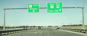
| 36 |  Route 3 - Boston (north), Cape Cod Route 3 - Boston (north), Cape CodCape Cod Cape Cod, often referred to locally as simply the Cape, is a cape in the easternmost portion of the state of Massachusetts, in the Northeastern United States... (south) |
Eastbound exit and westbound entrance; US 44 joins Route 3 south eastbound and leaves Route 3 north westbound | |