

U.S. Route 202
Encyclopedia
U.S. Route 202 is a highway stretching from Delaware
to Maine
, also passing through the states of Pennsylvania
, New Jersey
, New York
, Connecticut
, Massachusetts
, and New Hampshire
.
The road has borne the number 202 since at least 1935. Before this, sections of the road were designated U.S. Route 122, as it intersected U.S. Route 22. Its current designation is based on its intersection with US 2 in Maine.
This route is considerably longer than the eastern segment of US 2, making it one of several 3-digit US routes to be longer than their parent routes.
/US 40
south of Wilmington
. It runs north along the same road as Delaware Route 141
, then joins with Interstate 95
through Wilmington. North of the city, it exits the freeway onto Concord Pike, heading north; Delaware Route 202
also continues south from this point. US 202 continues north towards the state line as a six-lane arterial road
and is lined with numerous strip malls and "big-box stores".
 US 202 continues north toward West Chester
, joining with US 322
north of U.S. Route 1
. South of West Chester
, US 202/322 exits onto a limited-access bypass of the borough; that is the old West Chester By-Pass, and includes a grade-level intersection at Matlack Street. North of West Chester, US 322 exits, and US 202 continues north as a freeway towards Frazer
, where it interchanges with U.S. Route 30
and bends east to head towards Malvern
and King of Prussia
. The stretch between Valley Road in Paoli and King of Prussia was recently widened to three lanes in each direction. In King of Prussia, the highway forms a large, complicated interchange with the Schuylkill Expressway
, the Pennsylvania Turnpike
, and U.S. Route 422
.
The freeway then transitions into a divided highway
, passing the King of Prussia Mall
and heading northeast through commercial areas before splitting into a one-way pair
through the streets of Bridgeport
and Norristown
, crossing the Schuylkill River
in the process.
 North of Norristown, US 202 continues as a two-lane road heading northeast through the Philadelphia suburbs, passing through Blue Bell
and Lower Gwynedd
, where it becomes a four-lane full-access highway for about two miles (3 km). East of Lansdale
, in Montgomeryville
, it briefly joins with Pennsylvania Route 309
, splitting off at a large, complex intersection locally known as "Five Points". It continues northeast towards Doylestown
, bypassing the town first on a wrong-way concurrency on PA 611
then on a short bypass that ends at PA 313
. It continues as a two-lane road to New Hope
, crossing the Delaware River
on the New Hope-Lambertville Toll Bridge
.
Construction began in November 2008 on a parkway project between PA 63
in Lower Gwynedd and the existing cloverleaf interchange at the US 202 Bypass and PA 611 near Doylestown. This parkway will consist of a four-lane stretch between PA 63 and PA 463
and a two-lane parkway the rest of the way that bypasses the borough
s of Chalfont
and New Britain
.
-Lambertville
area) from its original route. The old section of 202 between New Hope and Ringoes, New Jersey
is now NJ 179 which is also Old York Road
, the first roadway to connect New York City
and Philadelphia, Pennsylvania
. In 1953, this section of Old York Road was renumbered US 202. A small section of the US 202 bypass was built in 1965 and the old route was renamed NJ 179. When the western section of the "bypass" was built to the Delaware River, the whole former segment was renamed 179. The section of the new US 202 freeway section ends once it begins to run concurrently with NJ 31 in East Amwell Township
. The concurrency runs for five miles (8 km), to Flemington
. This stretch, and the 13 miles (21 km) between Flemington and Somerville
, is a four-lane divided roadway.
 At Somerville, the road merges with US 206
at a now-reconfigured Somerville Circle
. Parts of the old traffic circle
, which also carries NJ 28, remain below the US 202 flyover
. US 202 splits northeastward from US 206 at Bedminster Township
and again becomes a two-lane road.
From here to the state line, US 202 parallels, and has largely been supplanted by, I-287
, which during its construction dumped traffic onto US 202. US 202 continues through Morristown
to Morris Plains
with an intersection with NJ 53
. Interestingly, with a few exceptions, US 202 is maintained by counties rather than the New Jersey Department of Transportation
north of NJ 53.
The following sections are state-maintained:
US 202 continues past Boonton
along the Boonton Turnpike to Wayne
, where it then picks up NJ 23 for about two miles (3 km) and then exits on Black Oak Ridge Road. It then follows the Paterson-Hamburg Turnpike and Ramapo Valley Road (more or less paralleling the Ramapo River through Oakland) to Mahwah
before crossing the New York state line on the Franklin Turnpike.
Franklin Turnpike becomes Orange Avenue in Suffern
, and US 202 continues to a block-long wrong-way concurrency with NY 59
before tailing off on Wayne Avenue and heading east toward Haverstraw
. Most of this stretch is two-lane road.
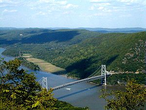
At Haverstraw, US 202 turns north along US 9W
to Bear Mountain
and then crosses the Bear Mountain Bridge
, running concurrently with US 6
, the Grand Army Highway. The two wind around Anthony's Nose
, briefly forming New York's only three-way concurrency of U.S. highways with US 9 at Peekskill
. Afterwards, the two separate for several miles, with US 202 taking the more southerly route through Somers
. The highways reunite at Brewster
and become a four-lane road for their last few miles before the state line, taking in NY 121
in the process.
, US 6 and 202 climb up onto I-84
, which had just been joined by the north–south US 7
, making a four-way concurrency. Until recently, 202 ran with U.S. Route 7, however recent construction has separated the two highways. 202 splits from I-84 and US 6 at Exit 2. It is a two-lane road in southern Brookfield
as it follows Federal Road. The US 7 freeway continues for another 6.5 miles (10.5 km) before it rejoins US 202 at the Brookfield/New Milford town line. The now rejoined US 7 and 202 approach New Milford
in bucolic Litchfield County
, where they once again split.
US 202 continues through Torrington
and on to Cherry Brook, where it then runs concurrently with US 44
for several miles before turning northward at Avon
. For the run to the state line, US 202 runs concurrently with Route 10
.
US 202 and Route 10
enter the Bay State at the "Congamond Notch" in Southwick
, a southward jog in the state line that includes Congamond Lake. North of Westfield
, US 202 turns eastward toward Holyoke
and Belchertown
. It then heads north along the west side of the Quabbin Reservoir
through New Salem
toward Athol
. This section of US 202 has been dubbed the Daniel Shays
Highway, named for a Revolutionary War veteran who led an insurrection against the state government of Massachusetts. US 202 meets Route 2
at Orange
, and runs along the two-lane freeway
to Phillipston
. There, it diverges to the north again as a two-lane road.
In Massachusetts, US 202 passes through the municipalities of Southwick, Westfield, Holyoke, South Hadley, Granby, Belchertown, Pelham, Shutesbury, New Salem, Orange, Athol, Phillipston, Templeton, and Winchendon.
It heads north, through Jaffrey
, to Hillsborough
, where it turns eastward along a concurrency with New Hampshire Route 9
. The span of the road between Hillsborough and Hopkinton
, which passes through Henniker
, is among the most deadly sections of roadway in the state. At Concord, New Hampshire
, the state capital, US 202 heads north and picks up a concurrency with US 3
for a short time, and then turns eastward again along Interstate 393
, a freeway spur that also carries US 4
. The freeway ends short of Chichester
, and NH 9 rejoins the two-lane concurrency along with US 4 and 202.
At Northwood
, US 202 and NH 9 leave US 4. NH 9 splits off a few miles later, leaving US 202 to continue alone toward Rochester
, where the road jumps up onto the Spaulding Turnpike
(NH 16
) for a short, non-tolled distance. US 202 leaves the turnpike two miles (3 km) before the state line at East Rochester
.
The highway enters the state by crossing the Salmon Falls River
at South Lebanon
and bridges the Mousam River
in Sanford
. The highway then passes through Alfred
, Waterboro
and Hollis
before crossing the Saco River
at Salmon Falls
. The highway passes through Gorham
and crosses the Presumpscot River
into South Windham
. There is a rotary with U.S. Route 302
at Foster's Corner
and an interchange with I-95
at Gray
. The highway parallels I-95 through Upper Gloucester
to Auburn
and crosses the Androscoggin River
into Lewiston
, passing near the campus of Bates College
. A very short stretch through the latter two cities is four-lane highway, but most of its length in the Pine Tree State consists of two-lane road. Its final miles west of Hampden, including the short overlay on I-395, and concurrency with US 1A also include four-laned segments.
The highway passes through Greene
, Monmouth
, and Winthrop concurrently with State Route 11
and State Route 100
, and becomes concurrent with State Route 17 at Manchester
. US 202 runs concurrently with U.S. Route 201
as it crosses the Kennebec River
at Augusta
, and shortly thereafter it picks up State Route 3 and State Route 9. SR 3 splits off at South China
, but SR 9 stays with US 202 through Albion
, Unity
, Troy
, Dixmont
, Newburgh
, and Hampden almost all the way to its terminus in Bangor
. When SR 9 turns right onto Summer Street in Bangor with US 1A, US 202 runs 4 more blocks to its eastern terminus at the US 2 rotary at the corner of Hammond, Main, Central and State Streets.
A proposed extension eastward of US 202 would run up State Street in Bangor with US 2, turning east onto Broadway/Oak St across the bridge to Brewer
(the unposted US 1A Business route), and then following SR 9 again and then with US 1 to Calais
utilizing the under-construction/proposed 'third Calais crossing'. This is part of the Maine East–West Corridor.
with Wilmington, Delaware
. It became part of US 202 in 1934.
was proposed that would follow the US 202 corridor. The "Piedmont Expressway" was to be 59 miles (95 km) long, and would cost approximately $146 million. It was to serve as an outer beltway around the Philadelphia area, similar to the Capital Beltway
that encircles Washington, D.C.
Delaware
Delaware is a U.S. state located on the Atlantic Coast in the Mid-Atlantic region of the United States. It is bordered to the south and west by Maryland, and to the north by Pennsylvania...
to Maine
Maine
Maine is a state in the New England region of the northeastern United States, bordered by the Atlantic Ocean to the east and south, New Hampshire to the west, and the Canadian provinces of Quebec to the northwest and New Brunswick to the northeast. Maine is both the northernmost and easternmost...
, also passing through the states of Pennsylvania
Pennsylvania
The Commonwealth of Pennsylvania is a U.S. state that is located in the Northeastern and Mid-Atlantic regions of the United States. The state borders Delaware and Maryland to the south, West Virginia to the southwest, Ohio to the west, New York and Ontario, Canada, to the north, and New Jersey to...
, New Jersey
New Jersey
New Jersey is a state in the Northeastern and Middle Atlantic regions of the United States. , its population was 8,791,894. It is bordered on the north and east by the state of New York, on the southeast and south by the Atlantic Ocean, on the west by Pennsylvania and on the southwest by Delaware...
, New York
New York
New York is a state in the Northeastern region of the United States. It is the nation's third most populous state. New York is bordered by New Jersey and Pennsylvania to the south, and by Connecticut, Massachusetts and Vermont to the east...
, Connecticut
Connecticut
Connecticut is a state in the New England region of the northeastern United States. It is bordered by Rhode Island to the east, Massachusetts to the north, and the state of New York to the west and the south .Connecticut is named for the Connecticut River, the major U.S. river that approximately...
, Massachusetts
Massachusetts
The Commonwealth of Massachusetts is a state in the New England region of the northeastern United States of America. It is bordered by Rhode Island and Connecticut to the south, New York to the west, and Vermont and New Hampshire to the north; at its east lies the Atlantic Ocean. As of the 2010...
, and New Hampshire
New Hampshire
New Hampshire is a state in the New England region of the northeastern United States of America. The state was named after the southern English county of Hampshire. It is bordered by Massachusetts to the south, Vermont to the west, Maine and the Atlantic Ocean to the east, and the Canadian...
.
The road has borne the number 202 since at least 1935. Before this, sections of the road were designated U.S. Route 122, as it intersected U.S. Route 22. Its current designation is based on its intersection with US 2 in Maine.
This route is considerably longer than the eastern segment of US 2, making it one of several 3-digit US routes to be longer than their parent routes.
Delaware
US 202 begins at an interchange with US 13U.S. Route 13
U.S. Route 13 is a north–south U.S. highway established in 1926 that runs for from Interstate 95 just north of Fayetteville, North Carolina to the northeastern suburbs of Philadelphia, Pennsylvania, in Morrisville. In all, it traverses five states in the Atlantic coastal plain region,...
/US 40
U.S. Route 40
U.S. Route 40 is an east–west United States highway. As with most routes whose numbers end in a zero, U.S. 40 once traversed the entire United States. It is one of the original 1920s U.S. Highways, and its first termini were San Francisco, California, and Atlantic City, New Jersey...
south of Wilmington
Wilmington, Delaware
Wilmington is the largest city in the state of Delaware, United States, and is located at the confluence of the Christina River and Brandywine Creek, near where the Christina flows into the Delaware River. It is the county seat of New Castle County and one of the major cities in the Delaware Valley...
. It runs north along the same road as Delaware Route 141
Delaware Route 141
Delaware Route 141 is a bypass around the western suburbs of Wilmington, Delaware. Its northern terminus is an interchange with U.S. Route 202 and Delaware Route 261 in Fairfax, and its southern terminus is at Delaware Route 9 and Delaware Route 273 in New Castle...
, then joins with Interstate 95
Interstate 95 in Delaware
In Delaware, Interstate 95 runs diagonally from the border with Maryland northeast to the border with Pennsylvania. Between the Maryland state line and exit 5, I-95 is also designated as the Delaware Turnpike and the John F. Kennedy Memorial Highway. Along with its auxiliaries, I-95 is the only...
through Wilmington. North of the city, it exits the freeway onto Concord Pike, heading north; Delaware Route 202
Delaware Route 202
Delaware Route 202, also known as Concord Avenue, is a short state highway in Wilmington, Delaware. It runs from Business U.S. Route 13 to a modified cloverleaf interchange with Interstate 95 and U.S. Route 202 at the northern city limits. North of the interchange, the route becomes US 202...
also continues south from this point. US 202 continues north towards the state line as a six-lane arterial road
Arterial road
An arterial road, or arterial thoroughfare, is a high-capacity urban road. The primary function of an arterial road is to deliver traffic from collector roads to freeways, and between urban centres at the highest level of service possible. As such, many arteries are limited-access roads, or feature...
and is lined with numerous strip malls and "big-box stores".
Pennsylvania
West Chester, Pennsylvania
The Borough of West Chester is the county seat of Chester County, Pennsylvania, United States. The population was 18,461 at the 2010 census.Valley Forge, the Brandywine Battlefield, Longwood Gardens, Marsh Creek State Park, and other historical attractions are near West Chester...
, joining with US 322
U.S. Route 322
U.S. Route 322 is a long, east–west United States Highway, traversing Ohio, Pennsylvania, and New Jersey. The road is a spur of U.S. Route 22 and one of the original highways from 1926...
north of U.S. Route 1
U.S. Route 1
U.S. Route 1 is a major north–south U.S. Highway that serves the East Coast of the United States. It runs 2,377 miles from Fort Kent, Maine at the Canadian border south to Key West, Florida. U.S. 1 generally parallels Interstate 95, though it is significantly farther west between...
. South of West Chester
West Chester, Pennsylvania
The Borough of West Chester is the county seat of Chester County, Pennsylvania, United States. The population was 18,461 at the 2010 census.Valley Forge, the Brandywine Battlefield, Longwood Gardens, Marsh Creek State Park, and other historical attractions are near West Chester...
, US 202/322 exits onto a limited-access bypass of the borough; that is the old West Chester By-Pass, and includes a grade-level intersection at Matlack Street. North of West Chester, US 322 exits, and US 202 continues north as a freeway towards Frazer
Frazer, Pennsylvania
Frazer, Pennsylvania is a community in East Whiteland Township, Pennsylvania, United States....
, where it interchanges with U.S. Route 30
U.S. Route 30
U.S. Route 30 is an east–west main route of the system of United States Numbered Highways, with the highway traveling across the northern tier of the country. It is the third longest U.S. route, after U.S. Route 20 and U.S. Route 6. The western end of the highway is at Astoria, Oregon; the...
and bends east to head towards Malvern
Malvern, Pennsylvania
Malvern is a borough in Chester County, Pennsylvania, United States. The population was 2,998 at the 2010 census. The main road through the borough is King Street, although the borough is also bordered by Paoli Pike on the south, and is near US 30 on the north. The primary cross street is Warren...
and King of Prussia
King of Prussia, Pennsylvania
King of Prussia is a census-designated place in Upper Merion Township, Montgomery County, Pennsylvania, United States. As of the 2010 census, its population was 19,936. The community took its name in the 18th century from a local tavern named the King of Prussia Inn, which was named after...
. The stretch between Valley Road in Paoli and King of Prussia was recently widened to three lanes in each direction. In King of Prussia, the highway forms a large, complicated interchange with the Schuylkill Expressway
Schuylkill Expressway
The Schuylkill Expressway , locally known as the Schuylkill, is a freeway through southwestern Montgomery County and the city of Philadelphia, and the easternmost segment of Interstate 76 in the U.S. state of Pennsylvania...
, the Pennsylvania Turnpike
Pennsylvania Turnpike
The Pennsylvania Turnpike is a toll highway system operated by the Pennsylvania Turnpike Commission in the Commonwealth of Pennsylvania, United States. The three sections of the turnpike system total . The main section extends from Ohio to New Jersey and is long...
, and U.S. Route 422
U.S. Route 422
U.S. Route 422 is a long spur route of US 22 split into two segments in the U.S. states of Ohio and Pennsylvania. The western spur begins in downtown Cleveland, Ohio, and ends at Ebensburg, Pennsylvania...
.
The freeway then transitions into a divided highway
Divided Highway
Divided Highway is a compilation album by American rock band The Doobie Brothers, released in 2003. . All tracks are taken from the albums Cycles and Brotherhood .-Track listing:...
, passing the King of Prussia Mall
King of Prussia Mall
The King of Prussia Mall is the largest shopping mall on the East Coast of the United States, and largest shopping mall in the United States of America in terms of leasable retail space....
and heading northeast through commercial areas before splitting into a one-way pair
One-way pair
A one-way pair, one-way couple, or just couplet is a pair of parallel, usually one-way streets that carry opposite directions of a signed route or major traffic flow, or sometimes opposite directions of a bus or streetcar route....
through the streets of Bridgeport
Bridgeport, Pennsylvania
Bridgeport is a borough in Montgomery County, Pennsylvania, 18 miles north of Philadelphia on the Schuylkill River. The old-time industries were paper, flour, cotton, and woolen mills, steel works, brickyards, etc. Bridgeport is six miles east of Valley Forge, Pennsylvania...
and Norristown
Norristown, Pennsylvania
Norristown is a municipality in Montgomery County, Pennsylvania, northwest of the city limits of Philadelphia, on the Schuylkill River. The population was 34,324 as of the 2010 census. It is the county seat of Montgomery County...
, crossing the Schuylkill River
Schuylkill River
The Schuylkill River is a river in Pennsylvania. It is a designated Pennsylvania Scenic River.The river is about long. Its watershed of about lies entirely within the state of Pennsylvania. The source of its eastern branch is in the Appalachian Mountains at Tuscarora Springs, near Tamaqua in...
in the process.
Blue Bell, Pennsylvania
Blue Bell is a census-designated place in Whitpain Township in Montgomery County, Pennsylvania, in the United States. As of the 2010 census, its population was 6,067....
and Lower Gwynedd
Lower Gwynedd Township, Pennsylvania
Lower Gwynedd Township is a township in Montgomery County, Pennsylvania, United States. The population was 11,405 at the 2010 census. The township comprises four villages: Gwynedd, Gwynedd Valley, Penllyn, and Spring House....
, where it becomes a four-lane full-access highway for about two miles (3 km). East of Lansdale
Lansdale, Pennsylvania
Lansdale is a borough in Montgomery County, Pennsylvania, 28 miles northwest of Philadelphia. Early in the 20th century, its industries included agricultural implement works, a canning factory, foundries, brickyards, a silk mill, and manufacturers of cigars, stoves, shirts, rope, iron drain pipe,...
, in Montgomeryville
Montgomeryville, Pennsylvania
Montgomeryville is a census-designated place in Montgomery County, Pennsylvania, United States. The population was 12,624 at the 2010 census....
, it briefly joins with Pennsylvania Route 309
Pennsylvania Route 309
Pennsylvania Route 309 is a major highway which runs for 134 miles through Pennsylvania in the United States. It connects Philadelphia and its northern suburbs to Allentown, Hazleton, and Wilkes-Barre. A limited-access highway portion of PA 309 in the Wilkes-Barre area is known as the North...
, splitting off at a large, complex intersection locally known as "Five Points". It continues northeast towards Doylestown
Doylestown, Pennsylvania
Doylestown is a borough in Bucks County, Pennsylvania, north of Philadelphia. As of the 2010 census, the borough population was 8,380. The borough is the county seat of Bucks County.- History :...
, bypassing the town first on a wrong-way concurrency on PA 611
Pennsylvania Route 611
Pennsylvania Route 611 is a major state highway in Pennsylvania, United States, running from Interstate 95 south of downtown Philadelphia north to Interstate 380 in Coolbaugh Township, Pennsylvania in The Poconos....
then on a short bypass that ends at PA 313
Pennsylvania Route 313
Pennsylvania Route 313 is a mostly 2-lane, long state highway entirely within Bucks County, Pennsylvania. It is an east–west road, although it runs almost purely northwest/southeast through most of its course...
. It continues as a two-lane road to New Hope
New Hope, Pennsylvania
New Hope, formerly known as Coryell's Ferry, is a borough in Bucks County, Pennsylvania, USA. The population was 2,528 at the 2010 census. The borough lies on the west bank of the Delaware River at its confluence with Aquetong Creek. A two-lane bridge carries automobile and foot traffic across the...
, crossing the Delaware River
Delaware River
The Delaware River is a major river on the Atlantic coast of the United States.A Dutch expedition led by Henry Hudson in 1609 first mapped the river. The river was christened the South River in the New Netherland colony that followed, in contrast to the North River, as the Hudson River was then...
on the New Hope-Lambertville Toll Bridge
New Hope-Lambertville Toll Bridge
The New Hope-Lambertville Toll Bridge carries U.S. Route 202 over the Delaware River, connecting Delaware Township in Hunterdon County with Solebury Township in Bucks County. The bridge, which opened in 1971, was built and is currently operated by the Delaware River Joint Toll Bridge Commission...
.
Construction began in November 2008 on a parkway project between PA 63
Pennsylvania Route 63
Pennsylvania Route 63 is a long state highway located in the Philadelphia, Pennsylvania area. The western terminus of the route is at PA 29 in Green Lane, Montgomery County. The eastern terminus is at Interstate 95 in Bensalem Township, Bucks County...
in Lower Gwynedd and the existing cloverleaf interchange at the US 202 Bypass and PA 611 near Doylestown. This parkway will consist of a four-lane stretch between PA 63 and PA 463
Pennsylvania Route 463
Pennsylvania Route 463 is a long route completely in Montgomery County, Pennsylvania. Its western terminus is at PA 63 in Hatfield Township and its eastern terminus is at PA 611 in Horsham. It runs through the northern suburban areas of Philadelphia and passes through the towns...
and a two-lane parkway the rest of the way that bypasses the borough
Borough (Pennsylvania)
In the U.S. Commonwealth of Pennsylvania, a borough is a self-governing municipal entity that is usually smaller than a city. There are 958 boroughs in Pennsylvania. All municipalities in Pennsylvania are classified as either cities, boroughs, or townships...
s of Chalfont
Chalfont, Pennsylvania
Chalfont is a home rule municipality located in Bucks County, Pennsylvania, United States. The population was 4,009 at the 2010 census.Chalfont is named after Chalfont St Giles in Buckinghamshire, England...
and New Britain
New Britain, Pennsylvania
New Britain is a borough in Bucks County, Pennsylvania, United States. The population was 3,152 at the 2010 census.-Geography:New Britain is located at ....
.
New Jersey
On the toll bridge, US 202 has two lanes in each direction. It continues a northeasterly course for about 5.7 miles (9.2 km) as a freeway. This segment of US 202 was earlier called the 202 bypass (as it bypassed the New HopeNew Hope, Pennsylvania
New Hope, formerly known as Coryell's Ferry, is a borough in Bucks County, Pennsylvania, USA. The population was 2,528 at the 2010 census. The borough lies on the west bank of the Delaware River at its confluence with Aquetong Creek. A two-lane bridge carries automobile and foot traffic across the...
-Lambertville
Lambertville, New Jersey
Lambertville is a city in Hunterdon County, New Jersey, United States. As of the 2010 United States Census, the city population was 3,906.Lambertville was originally incorporated as a town by an Act of the New Jersey Legislature on March 1, 1849, from portions of West Amwell Township...
area) from its original route. The old section of 202 between New Hope and Ringoes, New Jersey
Ringoes, New Jersey
Ringoes is an unincorporated area located within East Amwell Township, in Hunterdon County, New Jersey. The community is served by the United States Postal Service as ZIP Code 08551. As of the United States 2000 Census, the population for ZIP Code Tabulation Area 08551 was 5,082.-History:Ringoes is...
is now NJ 179 which is also Old York Road
Old York Road
Old York Road or King's Highway is a roadway that was built in the 18th century to connect Philadelphia, Pennsylvania with New York City, New York. Through New Jersey it was built along the Raritan "Naraticong Trail"...
, the first roadway to connect New York City
New York City
New York is the most populous city in the United States and the center of the New York Metropolitan Area, one of the most populous metropolitan areas in the world. New York exerts a significant impact upon global commerce, finance, media, art, fashion, research, technology, education, and...
and Philadelphia, Pennsylvania
Pennsylvania
The Commonwealth of Pennsylvania is a U.S. state that is located in the Northeastern and Mid-Atlantic regions of the United States. The state borders Delaware and Maryland to the south, West Virginia to the southwest, Ohio to the west, New York and Ontario, Canada, to the north, and New Jersey to...
. In 1953, this section of Old York Road was renumbered US 202. A small section of the US 202 bypass was built in 1965 and the old route was renamed NJ 179. When the western section of the "bypass" was built to the Delaware River, the whole former segment was renamed 179. The section of the new US 202 freeway section ends once it begins to run concurrently with NJ 31 in East Amwell Township
East Amwell Township, New Jersey
-History:During the American Revolutionary War, a small but important skirmish occurred in East Amwell when local militia under Capt. John Schenck ambushed a party of British dragoons near Larison's Corner...
. The concurrency runs for five miles (8 km), to Flemington
Flemington, New Jersey
Flemington is a borough in Hunterdon County, New Jersey, United States. As of the United States 2010 Census, the borough population was 4,581. It is the county seat of Hunterdon County....
. This stretch, and the 13 miles (21 km) between Flemington and Somerville
Somerville, New Jersey
Somerville is a borough in Somerset County, New Jersey, United States. As of the 2010 United States Census, the borough population was 12,098. It is the county seat of Somerset County....
, is a four-lane divided roadway.
U.S. Route 206
U.S. Route 206 is a long north–south United States highway in New Jersey and Pennsylvania, United States. Only about a half a mile of its length is in Pennsylvania; the Milford-Montague Toll Bridge carries it over the Delaware River into New Jersey, where it is the remainder of the route...
at a now-reconfigured Somerville Circle
Somerville Circle
The Somerville Circle is a traffic circle located on the border of Bridgewater Township and Raritan, New Jersey, United States. The circle is at the intersection of U.S. Routes 202 and 206, and New Jersey Route 28...
. Parts of the old traffic circle
Traffic circle
A traffic circle or rotary is a type of circular intersection in which traffic must travel in one direction around a central island. In some countries, traffic entering the circle has the right-of-way and drivers in the circle must yield. In many other countries, traffic entering the circle must...
, which also carries NJ 28, remain below the US 202 flyover
Overpass
An overpass is a bridge, road, railway or similar structure that crosses over another road or railway...
. US 202 splits northeastward from US 206 at Bedminster Township
Bedminster Township, New Jersey
Bedminster Township is a Township in Somerset County, New Jersey, United States. As of the 2010 United States Census, the township population was 8,165....
and again becomes a two-lane road.
From here to the state line, US 202 parallels, and has largely been supplanted by, I-287
Interstate 287
Interstate 287 is an auxiliary Interstate Highway in the U.S. states of New Jersey and New York. It is a partial beltway around New York City, serving the northern half of New Jersey and the counties of Rockland and Westchester in New York...
, which during its construction dumped traffic onto US 202. US 202 continues through Morristown
Morristown, New Jersey
Morristown is a town in Morris County, New Jersey, United States. As of the 2010 United States Census, the town population was 18,411. It is the county seat of Morris County. Morristown became characterized as "the military capital of the American Revolution" because of its strategic role in the...
to Morris Plains
Morris Plains, New Jersey
Morris Plains, billing itself "the Community of Caring," is a Borough in Morris County, New Jersey, United States. As of the United States 2000 Census, the borough population was 5,236....
with an intersection with NJ 53
New Jersey Route 53
-External links:***...
. Interestingly, with a few exceptions, US 202 is maintained by counties rather than the New Jersey Department of Transportation
New Jersey Department of Transportation
The New Jersey Department of Transportation is the agency responsible for transportation issues and policy in New Jersey. It is headed by the Commissioner of Transportation...
north of NJ 53.
The following sections are state-maintained:
- At the I-80Interstate 80 in New JerseyInterstate 80 is a major Interstate Highway in the United States, running from the New York City Metropolitan Area westward to San Francisco, California...
interchange - At the US 46U.S. Route 46U.S. Route 46 is an east–west U.S. Highway, running for , completely within the state of New Jersey. The west end is at an interchange with Interstate 80 and Route 94 in Columbia, Warren County on the Delaware River...
intersection - Along the NJ 23 concurrency
- At the I-287Interstate 287Interstate 287 is an auxiliary Interstate Highway in the U.S. states of New Jersey and New York. It is a partial beltway around New York City, serving the northern half of New Jersey and the counties of Rockland and Westchester in New York...
interchange in OaklandOakland, New JerseyOakland is a borough in Bergen County, New Jersey, United States. As of the 2010 United States Census, the borough population was 12,754.Oakland was incorporated as a borough by an Act of the New Jersey Legislature on April 8, 1902, from portions of Franklin Township.-History:The Van Allen House...
US 202 continues past Boonton
Boonton, New Jersey
Boonton is a town in Morris County, New Jersey that was chartered in 1867. As of the 2010 United States Census, the town population was 8,347. The town was originally called "Boone-Towne" in 1761 in honor of the Colonial Governor Thomas Boone....
along the Boonton Turnpike to Wayne
Wayne, New Jersey
Wayne is a Township in Passaic County, New Jersey, United States, located less than from midtown Manhattan. As of the United States 2000 Census, the township had a total population of 54,069....
, where it then picks up NJ 23 for about two miles (3 km) and then exits on Black Oak Ridge Road. It then follows the Paterson-Hamburg Turnpike and Ramapo Valley Road (more or less paralleling the Ramapo River through Oakland) to Mahwah
Mahwah, New Jersey
Mahwah is a township in Bergen County, New Jersey, United States. As of the 2010 United States Census, the township population was 25,890. The name Mahwah is derived from the Lenni Lenape word "mawewi" which means "Meeting Place" or "Place Where Paths Meet".The area that is now Mahwah was...
before crossing the New York state line on the Franklin Turnpike.
New York
US 202 is mostly designated east–west in New York, owing to its greater coverage in those directions.Franklin Turnpike becomes Orange Avenue in Suffern
Suffern, New York
Suffern is a village in the Town of Ramapo, Rockland County, New York, United States located north of the State of New Jersey; east of Hillburn; south of Montebello and west of Airmont...
, and US 202 continues to a block-long wrong-way concurrency with NY 59
New York State Route 59
New York State Route 59 is an east–west state highway in southern Rockland County, New York, in the United States. The route extends for from NY 17 in Hillburn to U.S. Route 9W in Nyack. In Suffern, it has a concurrency with US 202 for . NY 59 runs parallel to the New...
before tailing off on Wayne Avenue and heading east toward Haverstraw
Haverstraw, New York
Haverstraw is the name of two locations in Rockland County, New York:*Haverstraw, New York, a town*Haverstraw , New York, a village located entirely within the townIt may also refer to:*West Haverstraw, New York*Haverstraw Bay*Haverstraw Indians...
. Most of this stretch is two-lane road.
At Haverstraw, US 202 turns north along US 9W
U.S. Route 9W
U.S. Route 9W is a north–south U.S. Highway in the states of New Jersey and New York. It begins on Fletcher Avenue in Fort Lee, New Jersey as it crosses the US 1 & 9, US 46, and the Interstate 95 approaches to the George Washington Bridge, where it heads north up the west...
to Bear Mountain
Bear Mountain (Hudson Highlands)
Bear Mountain is one of the best-known peaks of New York's Hudson Highlands. Located mostly in Orange County's Town of Highlands, it lends its name to a nearby bridge and the state park that contains it....
and then crosses the Bear Mountain Bridge
Bear Mountain Bridge
The Bear Mountain Bridge is a toll suspension bridge in New York State, carrying U.S. Highways 202 and 6 across the Hudson River between Rockland and Westchester counties...
, running concurrently with US 6
U.S. Route 6 in New York
U.S. Route 6 is a part of the U.S. Highway System that runs from Bishop, California, to Provincetown, Massachusetts. In New York, US 6 extends from the Pennsylvania state line at Port Jervis to the Connecticut state line east of Brewster...
, the Grand Army Highway. The two wind around Anthony's Nose
Anthony's Nose (Westchester)
Anthony's Nose is a peak along the Hudson River at the north end of Westchester County, New York.- Topography :Anthony's Nose, together with Dunderberg Mountain, comprises the South Gate of the Hudson Highlands...
, briefly forming New York's only three-way concurrency of U.S. highways with US 9 at Peekskill
Peekskill, New York
Peekskill is a city in Westchester County, New York. It is situated on a bay along the east side of the Hudson River, across from Jones Point.This community was known to be an early American industrial center, primarily for its iron plow and stove products...
. Afterwards, the two separate for several miles, with US 202 taking the more southerly route through Somers
Somers, New York
Somers is a town located in northeastern Westchester County, New York, United States. As of the 2010 census, the town had a population of 20,434...
. The highways reunite at Brewster
Brewster, New York
Brewster is a village within the town of Southeast in Putnam County, New York, United States. Its population was 2,162 at the 2000 census. The village is the most densely populated portion of the town...
and become a four-lane road for their last few miles before the state line, taking in NY 121
New York State Route 121
New York State Route 121 is a north–south state highway in New York, going from northern Westchester County to the village of Brewster in Putnam County.-Route description:...
in the process.
Connecticut
At DanburyDanbury, Connecticut
Danbury is a city in northern Fairfield County, Connecticut, United States. It had population at the 2010 census of 80,893. Danbury is the fourth largest city in Fairfield County and is the seventh largest city in Connecticut....
, US 6 and 202 climb up onto I-84
Interstate 84 in Connecticut
Interstate 84 is an East–West Interstate highway across the state of Connecticut into Danbury, Waterbury, Hartford and Union.-Route description:...
, which had just been joined by the north–south US 7
U.S. Route 7 in Connecticut
In the state of Connecticut, U.S. Route 7 runs from Canaan to Norwalk.-Route description:U.S. 7 in Connecticut is mostly a surface road but has two short expressway sections in the Norwalk and Danbury areas. US 7 begins in Norwalk with a expressway to nearly the Wilton town line...
, making a four-way concurrency. Until recently, 202 ran with U.S. Route 7, however recent construction has separated the two highways. 202 splits from I-84 and US 6 at Exit 2. It is a two-lane road in southern Brookfield
Brookfield, Connecticut
Brookfield is a town located in northern Fairfield County, Connecticut, United States. The population was 16,452 at the 2010 census. First settled in 1710 by John Muirwood and several other colonial founders who bartered for the land From the Wyantenuck Nation Under the Sachem Waramaugs who lived...
as it follows Federal Road. The US 7 freeway continues for another 6.5 miles (10.5 km) before it rejoins US 202 at the Brookfield/New Milford town line. The now rejoined US 7 and 202 approach New Milford
New Milford, Connecticut
New Milford is a town in southern Litchfield County, Connecticut, United States north of Danbury, on the Housatonic River. It is the largest town in the state in terms of land area at nearly . The population was 28,671 according to the Census Bureau's 2006 estimates...
in bucolic Litchfield County
Litchfield County, Connecticut
Litchfield County is a county located in the northwestern corner of the U.S. state of Connecticut. Litchfield County has the lowest population density of any county in Connecticut but is geographically the state's largest county. As of 2010 the population was 189,927...
, where they once again split.
US 202 continues through Torrington
Torrington, Connecticut
Torrington is the largest city in Litchfield County, Connecticut and the northwestern Connecticut region. It is also the core city of the largest micropolitan area in the United States. The city population was 36,383 according to the 2010 census....
and on to Cherry Brook, where it then runs concurrently with US 44
U.S. Route 44 in Connecticut
U.S. Route 44 is an east–west U.S. Highway running from Salisbury to Putnam.-Route description:From the New York state line at Salisbury to the Rhode Island state line at Putnam, US 44 runs for a total of in Connecticut. Most of US 44 is known in the state as the Jonathan Trumbull Highway...
for several miles before turning northward at Avon
Avon, Connecticut
Avon is a town in the Farmington Valley region of Hartford County, Connecticut, United States. , the town had a population of 18,098.Avon is a suburb of Hartford. Avon Old Farms School, a prestigious boarding school, is located there. In 2005, Avon was named the third-safest town in America by...
. For the run to the state line, US 202 runs concurrently with Route 10
Connecticut Route 10
Connecticut Route 10 is a state highway that runs between New Haven and the state line near Granby.-Route description:Route 10 begins at Interstate 95 as Ella T. Grasso Boulevard in the city of New Haven. It then passes by Southern Connecticut State University before entering the town of Hamden...
.
Massachusetts
Unlike elsewhere in New England, US 202 is posted as a south–north highway in Massachusetts, as the highway runs mostly in those directions for its length through the state.US 202 and Route 10
Route 10 (New England)
New England Route 10 was a multi-state north–south state highway in the New England region of the United States, running through Connecticut, Massachusetts, and New Hampshire. "Route 10" still exists as a continuous state highway in each of its original states, running from New Haven,...
enter the Bay State at the "Congamond Notch" in Southwick
Southwick, Massachusetts
Southwick is a town in Hampden County, Massachusetts, United States. The population was 9,502 at the 2010 census. It is part of the Springfield, Massachusetts Metropolitan Statistical Area.- History :...
, a southward jog in the state line that includes Congamond Lake. North of Westfield
Westfield, Massachusetts
Westfield is a city in Hampden County, in the Pioneer Valley of western Massachusetts, United States. It is part of the Springfield, Massachusetts Metropolitan Statistical Area. The population was 41,094 at the 2010 census. The ZIP Code is 01085 for homes and businesses, 01086 for Westfield State...
, US 202 turns eastward toward Holyoke
Holyoke, Massachusetts
Holyoke is a city in Hampden County, Massachusetts, United States, between the western bank of the Connecticut River and the Mount Tom Range of mountains. As of the 2010 Census, the city had a population of 39,880...
and Belchertown
Belchertown, Massachusetts
As of the census of 2000, there were 12,968 people, 4,886 households, and 3,517 families residing in the town. The population density was 245.9 people per square mile . There were 5,050 housing units at an average density of 95.8 per square mile...
. It then heads north along the west side of the Quabbin Reservoir
Quabbin Reservoir
The Quabbin Reservoir is the largest inland body of water in the Commonwealth of Massachusetts and was built between 1930 and 1939. Today along with the Wachusett Reservoir, it is the primary water supply for Boston, some to the east, as well as 40 other communities in Greater Boston...
through New Salem
New Salem, Massachusetts
New Salem is a town in Franklin County, Massachusetts, United States. The population was 990 at the 2000 census. It is part of the Springfield, Massachusetts Metropolitan Statistical Area.- History :...
toward Athol
Athol, Massachusetts
Athol is a town in Worcester County, Massachusetts, United States. The population was 11,584 at the 2010 census.-History:Originally called Pequoiag, the area was first settled by five families in September 1735. When the township was incorporated in 1762, the name was changed to Athol...
. This section of US 202 has been dubbed the Daniel Shays
Daniel Shays
Daniel Shays was an American soldier, revolutionary, and farmer famous for leading the Shays' Rebellion.-Early life:...
Highway, named for a Revolutionary War veteran who led an insurrection against the state government of Massachusetts. US 202 meets Route 2
Route 2 (Massachusetts)
Route 2 is a major east–west state highway in Massachusetts, parts of which are sometimes known as the Cambridge and Concord Turnpike. Along with Route 9 and U.S. Route 20 to the south, these highways are the main alternatives to the Massachusetts Turnpike/I-90 toll highway...
at Orange
Orange, Massachusetts
Orange is a town in Franklin County, Massachusetts, United States. The population was 7,839 at the 2010 census. It is part of the Springfield, Massachusetts Metropolitan Statistical Area.Part of the town is included in the census-designated place of Orange....
, and runs along the two-lane freeway
Two-lane freeway
A two-lane expressway is an expressway with only one lane in each direction, and usually no median barrier. It may be built that way because of constraints, or may be intended for expansion once traffic volumes rise. The term super two is often used by roadgeeks for this type of road, but traffic...
to Phillipston
Phillipston, Massachusetts
Phillipston is a town in Worcester County, Massachusetts, United States. The population was 1,682 at the 2010 census.- History :Phillipston was first settled in 1751, and incorporated as the town of Gerry in 1786...
. There, it diverges to the north again as a two-lane road.
In Massachusetts, US 202 passes through the municipalities of Southwick, Westfield, Holyoke, South Hadley, Granby, Belchertown, Pelham, Shutesbury, New Salem, Orange, Athol, Phillipston, Templeton, and Winchendon.
New Hampshire
US 202 is posted as an east–west highway in New Hampshire. It remains a two-lane highway for most of its length in the Granite State.It heads north, through Jaffrey
Jaffrey, New Hampshire
Jaffrey is a town in Cheshire County, New Hampshire, United States. The population was 5,457 at the 2010 census.The primary settlement in town, where 2,757 people resided at the 2010 census, is defined as the Jaffrey census-designated place and is located along the Contoocook River at the...
, to Hillsborough
Hillsborough, New Hampshire
Hillsborough, frequently spelled Hillsboro, is a town in Hillsborough County, New Hampshire, United States. The population was 6,011 at the 2010 census...
, where it turns eastward along a concurrency with New Hampshire Route 9
New England Interstate Route 9
Route 9 is a multi-state state highway in the New England region of the United States, running across the southern parts of New Hampshire, Vermont and Maine, and numbered, owned, and maintained by each of those states. Its number was assigned in 1922, when it was designated one of the New England...
. The span of the road between Hillsborough and Hopkinton
Hopkinton, New Hampshire
Hopkinton is a town in Merrimack County, New Hampshire, United States. The population was 5,589 at the 2010 census. It consists of three villages: Hopkinton, West Hopkinton, and Contoocook...
, which passes through Henniker
Henniker, New Hampshire
Henniker is a town in Merrimack County, New Hampshire, United States. As of the 2010 census, the town had a total population of 4,836. Henniker is home to New England College, Ames State Forest and Craney Hill State Forest....
, is among the most deadly sections of roadway in the state. At Concord, New Hampshire
Concord, New Hampshire
The city of Concord is the capital of the state of New Hampshire in the United States. It is also the county seat of Merrimack County. As of the 2010 census, its population was 42,695....
, the state capital, US 202 heads north and picks up a concurrency with US 3
U.S. Route 3
U.S. Route 3 is a north–south United States highway that runs from its southern terminus in Cambridge, Massachusetts through New Hampshire to its terminus near Third Connecticut Lake at the Canadian border, where the road continues north as Quebec Route 257.In New Hampshire parts of US 3 are...
for a short time, and then turns eastward again along Interstate 393
Interstate 393
Interstate 393 is a spur extending east from Interstate 93 at Concord, New Hampshire, USA. The primary purpose of the road is to bypass a densely-built commercial strip on Route 9 in the eastern part of Concord. Several times a year, I-393 also serves traffic to events at New Hampshire Motor...
, a freeway spur that also carries US 4
U.S. Route 4
U.S. Route 4 is a long United States highway that runs from East Greenbush, New York, in the west to Portsmouth, New Hampshire, in the east, traversing through Vermont.In New York, US 4 is signed north–south to reflect its alignment in the state...
. The freeway ends short of Chichester
Chichester, New Hampshire
Chichester is a town in Merrimack County, New Hampshire, United States. The population was 2,523 at the 2010 census.-History:Chichester was granted in 1727, named for Thomas Pelham-Holles, 1st Duke of Newcastle-upon-Tyne, Earl of Chichester, and England's Secretary of State for the Southern...
, and NH 9 rejoins the two-lane concurrency along with US 4 and 202.
At Northwood
Northwood, New Hampshire
Northwood is a town in Rockingham County, New Hampshire, United States. The population was 4,241 at the 2010 census.-History:First settled in 1763, Northwood was incorporated on February 6, 1773 by Colonial Governor John Wentworth, when a large tract of land called "North Woods" was separated from...
, US 202 and NH 9 leave US 4. NH 9 splits off a few miles later, leaving US 202 to continue alone toward Rochester
Rochester, New Hampshire
Rochester is a city in Strafford County, New Hampshire, United States. As of the 2010 census, the city population was 29,752. The city includes the villages of East Rochester and Gonic. Rochester is home to Skyhaven Airport and the annual Rochester Fair....
, where the road jumps up onto the Spaulding Turnpike
Spaulding Turnpike
The Spaulding Turnpike is a toll road in New Hampshire, USA, running from Interstate 95 in Portsmouth northwest to Milton. The turnpike roughly parallels the Maine border, and in the mid-1990s New Hampshire Route 16 was re-signed onto the turnpike...
(NH 16
New Hampshire Route 16
New Hampshire Route 16 is a long north–south highway in the U.S. state of New Hampshire. Much of its length is close to the border with Maine. NH 16 is the main route from the Seacoast region north to the Lakes Region and the White Mountains. The section from Portsmouth to Milton is a...
) for a short, non-tolled distance. US 202 leaves the turnpike two miles (3 km) before the state line at East Rochester
East Rochester, New Hampshire
East Rochester is a district of the city of Rochester, New Hampshire, located on the banks of the Salmon Falls River, which separates Maine from New Hampshire...
.
Maine
US 202 is posted as an east–west highway in Maine.The highway enters the state by crossing the Salmon Falls River
Salmon Falls River
The Salmon Falls River is a tributary of the Piscataqua River in the U.S. states of Maine and New Hampshire. It rises at Great East Lake and flows south-southeast for approximately , forming the border between Maine and New Hampshire....
at South Lebanon
Lebanon, Maine
Lebanon is a town in York County, Maine, United States. The population was 5,083 at the 2000 census. Lebanon includes the villages of Center Lebanon, West Lebanon, North Lebanon, South Lebanon and East Lebanon. It is part of the Portland–South Portland–Biddeford, Maine metropolitan...
and bridges the Mousam River
Mousam River
The Mousam River is a river in Maine in the United States. Its source is Mousam Lake in York County, and it flows into the Atlantic Ocean just west of Kennebunk Beach. It flows through the towns of Sanford and Kennebunk.-External links:...
in Sanford
Sanford, Maine
Sanford is a town in York County, Maine, United States. The population was 20,798 in the 2010 census, the highest of the York County towns, and the 8th largest in the state. Situated on the Mousam River, Sanford includes the village of Springvale...
. The highway then passes through Alfred
Alfred, Maine
Alfred is a town in York County, Maine, in the United States. As of the 2000 census, the town population was 2,497. Alfred is the county seat of York County and home to part of the Massabesic Experimental Forest...
, Waterboro
Waterboro, Maine
Waterboro is a town in York County, Maine, United States. The population was 6,214 at the 2000 census. It is part of the Portland–South Portland–Biddeford, Maine metropolitan statistical area....
and Hollis
Hollis, Maine
Hollis is a town in York County, Maine, United States. The population was 4,281 at the 2010 census. Hollis is a rural bedroom community of Portland and is part of the Portland–South Portland–Biddeford, Maine metropolitan statistical area.-History:...
before crossing the Saco River
Saco River
The Saco River is a river in northeastern New Hampshire and southwestern Maine in the United States. It drains a rural area of of forests and farmlands west and southwest of Portland, emptying into the Atlantic Ocean at Saco Bay, from its source. It supplies drinking water to roughly 250,000...
at Salmon Falls
Buxton, Maine
Buxton is a town in York County, Maine, United States. It is part of the Portland–South Portland–Biddeford, Maine Metropolitan Statistical Area. As of the 2000 census, the town had a total population of 7,452...
. The highway passes through Gorham
Gorham, Maine
Gorham is a town in Cumberland County, Maine, United States. The population was 16,381 at the 2010 census. In addition to an urban village center known as Gorham Village or simply "the Village," the town also encompasses a number of smaller, unincorporated villages and hamlets with distinct...
and crosses the Presumpscot River
Presumpscot River
The Presumpscot River is a river located in Cumberland County, Maine. It is the main outlet of Sebago Lake.-Course:The river flows through the communities of Standish, Windham, Gorham, Westbrook, Portland, and Falmouth before emptying into Casco Bay at Falmouth...
into South Windham
Little Falls-South Windham, Maine
Little Falls-South Windham was a census-designated place in Cumberland County, Maine, United States defined for the 2000 census. The population of the CDP was 1,792 at the time...
. There is a rotary with U.S. Route 302
U.S. Route 302
U.S. Route 302 is a spur of U.S. Route 2. It currently runs 171 miles north from Portland, Maine, at U.S. Route 1, to Montpelier, Vermont, at US 2...
at Foster's Corner
Windham, Maine
Windham is a town in Cumberland County, Maine, United States. The population was 17,001 at the 2010 census. It includes the villages of South Windham and North Windham...
and an interchange with I-95
Interstate 95 in Maine
In the U.S. state of Maine, Interstate 95 is a long highway running from the New Hampshire border near Kittery, to the Canadian border near Houlton. It is the only two-digit Interstate Highway in Maine...
at Gray
Gray, Maine
Gray is a town in Cumberland County, Maine, United States. The population was 6,820 at the 2000 census. It is part of the Portland–South Portland–Biddeford, Maine metropolitan statistical area. Gray is home to regional headquarters for the Maine Department of Inland Fisheries and...
. The highway parallels I-95 through Upper Gloucester
New Gloucester, Maine
New Gloucester is a town in Cumberland County, Maine, in the United States. It is home to the Sabbathday Lake Shaker Village, the last active Shaker Village in the U.S...
to Auburn
Auburn, Maine
Auburn is a city in and the county seat of Androscoggin County, Maine, United States. The population was 23,055 at the 2010 census. It is one of two principal cities of and included in the Lewiston-Auburn, Maine metropolitan New England city and town area and the Lewiston-Auburn, Maine metropolitan...
and crosses the Androscoggin River
Androscoggin River
The Androscoggin River is a river in the U.S. states of Maine and New Hampshire, in northern New England. It is long and joins the Kennebec River at Merrymeeting Bay in Maine before its water empties into the Gulf of Maine on the Atlantic Ocean. Its drainage basin is in area...
into Lewiston
Lewiston, Maine
Lewiston is a city in Androscoggin County in Maine, and the second-largest city in the state. The population was 41,592 at the 2010 census. It is one of two principal cities of and included within the Lewiston-Auburn, Maine metropolitan New England city and town area and the Lewiston-Auburn, Maine...
, passing near the campus of Bates College
Bates College
Bates College is a highly selective, private liberal arts college located in Lewiston, Maine, in the United States. and was most recently ranked 21st in the nation in the 2011 US News Best Liberal Arts Colleges rankings. The college was founded in 1855 by abolitionists...
. A very short stretch through the latter two cities is four-lane highway, but most of its length in the Pine Tree State consists of two-lane road. Its final miles west of Hampden, including the short overlay on I-395, and concurrency with US 1A also include four-laned segments.
The highway passes through Greene
Greene, Maine
Greene is a town in Androscoggin County, Maine, United States. The population was 4,076 at the 2000 census. It is included in both the Lewiston-Auburn, Maine Metropolitan Statistical Area and the Lewiston-Auburn, Maine Metropolitan New England City and Town Area.-History:Greene was settled in 1773...
, Monmouth
Monmouth, Maine
Monmouth is a town in Kennebec County, Maine, United States. The population was 3,785 at the 2000 census. It is a popular summer resort area, with many lakeside cottages.-History:...
, and Winthrop concurrently with State Route 11
State Route 11 (Maine)
State Route 11 is a state highway in Maine. It connects to New Hampshire Route 11 at its south end in Lebanon and travels through the counties of York, Cumberland, Androscoggin, Kennebec, Somerset, Waldo, Penobscot, Piscataquis, and Aroostook. The road ends at U.S...
and State Route 100
State Route 100 (Maine)
State Route 100 is a state highway in the U.S. state of Maine, running from Portland to Bangor.The south end of State Route 100 is at the intersection of Forest Avenue and Park Avenue in downtown Portland, the same place U.S. Route 302 ends. Both US 302 and State Route 100 pass under U.S. Route 1...
, and becomes concurrent with State Route 17 at Manchester
Manchester, Maine
Manchester is a town in Kennebec County, Maine, United States, located at . The population was 2,465 at the 2000 census. In the early 19th century, the town was known as "The Forks".-Geography:...
. US 202 runs concurrently with U.S. Route 201
U.S. Route 201
U.S. Route 201 is a spur of U.S. Route 1 in the U.S. state of Maine. US 201 begins in Brunswick. It follows the Kennebec River from Gardiner, Maine, to The Forks where it pulls away from the town and runs into the north woods. Route 201 ends in Sandy Bay Township, where it enters Quebec, Canada at...
as it crosses the Kennebec River
Kennebec River
The Kennebec River is a river that is entirely within the U.S. state of Maine. It rises in Moosehead Lake in west-central Maine. The East and West Outlets join at Indian Pond and the river then flows southward...
at Augusta
Augusta, Maine
Augusta is the capital of the US state of Maine, county seat of Kennebec County, and center of population for Maine. The city's population was 19,136 at the 2010 census, making it the third-smallest state capital after Montpelier, Vermont and Pierre, South Dakota...
, and shortly thereafter it picks up State Route 3 and State Route 9. SR 3 splits off at South China
South China, Maine
South China is a village in the town of China in Kennebec County, Maine, United States. It is one of four villages in China.-Communities:South China Lake is home to Friends Camp, a Quaker summer camp currently run by Nat Shed, which has been active for over 50 years. As well, it is the home of a...
, but SR 9 stays with US 202 through Albion
Albion, Maine
Albion is a town in Kennebec County, Maine, United States. The population was 1,946 at the 2000 census.-Geography:According to the United States Census Bureau, the town has a total area of , of which, of it is land and of it is water....
, Unity
Unity, Maine
Unity is a town in Waldo County, Maine, United States. The population was 1,889 at the 2000 census. The town is the service center for the northern portion of Waldo County...
, Troy
Troy, Maine
Troy is a town in Waldo County, Maine, United States. The population was 963 at the 2000 census.-Geography:According to the United States Census Bureau, the town has a total area of , of which, of it is land and of it is water.-Demographics:...
, Dixmont
Dixmont, Maine
Dixmont is a town in Penobscot County, Maine, United States. The population was 1,065 at the 2000 census. It is part of the Bangor, Maine Metropolitan Statistical Area.-Geography:...
, Newburgh
Newburgh, Maine
Newburgh is a town in Penobscot County, Maine, United States. The population was 1,394 at the 2000 census.-Geography:According to the United States Census Bureau, the town has a total area of , of which, of it is land and of it is water....
, and Hampden almost all the way to its terminus in Bangor
Bangor, Maine
Bangor is a city in and the county seat of Penobscot County, Maine, United States, and the major commercial and cultural center for eastern and northern Maine...
. When SR 9 turns right onto Summer Street in Bangor with US 1A, US 202 runs 4 more blocks to its eastern terminus at the US 2 rotary at the corner of Hammond, Main, Central and State Streets.
A proposed extension eastward of US 202 would run up State Street in Bangor with US 2, turning east onto Broadway/Oak St across the bridge to Brewer
Brewer, Maine
Brewer is a city in Penobscot County, Maine, United States. It is part of the Bangor, Maine Metropolitan Statistical Area. The city is named after its first settler, Colonel John Brewer. The population was 9,482 at the 2010 census....
(the unposted US 1A Business route), and then following SR 9 again and then with US 1 to Calais
Calais, Maine
Calais is a city in Washington County, Maine, United States. The city has three United States border crossings or also known as a Port of entry with the busiest being on the St. Croix River bordering St. Stephen, New Brunswick, Canada...
utilizing the under-construction/proposed 'third Calais crossing'. This is part of the Maine East–West Corridor.
History
U.S. Route 122 was created in 1926, connecting US 22 at Haverstraw, New YorkHaverstraw, New York
Haverstraw is the name of two locations in Rockland County, New York:*Haverstraw, New York, a town*Haverstraw , New York, a village located entirely within the townIt may also refer to:*West Haverstraw, New York*Haverstraw Bay*Haverstraw Indians...
with Wilmington, Delaware
Wilmington, Delaware
Wilmington is the largest city in the state of Delaware, United States, and is located at the confluence of the Christina River and Brandywine Creek, near where the Christina flows into the Delaware River. It is the county seat of New Castle County and one of the major cities in the Delaware Valley...
. It became part of US 202 in 1934.
The Piedmont Expressway
In Pennsylvania in the early 1960s, a four-lane expresswayLimited-access road
A limited-access road known by various terms worldwide, including limited-access highway, dual-carriageway and expressway, is a highway or arterial road for high-speed traffic which has many or most characteristics of a controlled-access highway , including limited or no access to adjacent...
was proposed that would follow the US 202 corridor. The "Piedmont Expressway" was to be 59 miles (95 km) long, and would cost approximately $146 million. It was to serve as an outer beltway around the Philadelphia area, similar to the Capital Beltway
Interstate 495 (Capital Beltway)
Interstate 495 is a Interstate Highway that surrounds the United States' capital of Washington, D.C., and its inner suburbs in adjacent Maryland and Virginia. I-495 is widely known as the Capital Beltway or simply the Beltway, especially when the context of Washington, D.C., is clear...
that encircles Washington, D.C.
Washington, D.C.
Washington, D.C., formally the District of Columbia and commonly referred to as Washington, "the District", or simply D.C., is the capital of the United States. On July 16, 1790, the United States Congress approved the creation of a permanent national capital as permitted by the U.S. Constitution....
External links
- New Jersey section of U.S. Route 202 Straight Line Diagram from the New Jersey Department of TransportationNew Jersey Department of TransportationThe New Jersey Department of Transportation is the agency responsible for transportation issues and policy in New Jersey. It is headed by the Commissioner of Transportation...
- An enlarged view of road jurisdiction of US 202, NJ 124 and CR 510 in Morristown
- New Jersey Roads: U.S. Route 202
- Speed Limits for New Jersey State Roads: U.S. Route 202 in New Jersey