

U.S. Route 322
Encyclopedia
U.S. Route 322 is a 494 mi (795 km) long, east–west United States Highway, traversing Ohio
, Pennsylvania
, and New Jersey
. The road is a spur
of U.S. Route 22
and one of the original highways from 1926. A portion of it at one time was concurrent with the Lakes-to-Sea Highway
.
|OH
|62
|99
|-
|PA
|370
|595
|-
|NJ
|62
|99
|}
in Downtown Cleveland
, just northeast of the junction of U.S. Routes US 6
, US 42
, and State Route 3 (Superior Avenue) with US 422
and Ohio State Routes State Route 8, State Route 14, State Route 43, and State Route 87 (i.e. Ontario Street). East of Public Square, the route runs eastward through midtown Cleveland conjoined with US 6 along Superior Avenue. Northwest of Cleveland State University
, US 322 turns south onto 13th Street and runs eastward (as Chester Avenue) through Playhouse Square. Exiting the commercial district, US 322 interchanges Interstate 90
, at exit 173. In University Circle
, US 322 is briefly concurrent with U.S. Route 20
(Euclid Avenue). The overlap terminates at the eastern edge of University Circle, where US 322 splits off to the south by southwest, becoming Mayfield Road as it enters Little Italy, and through the eastern suburb
s of Cleveland Heights
, South Euclid, Lyndhurst
, Mayfield Heights, and Gates Mills
, continuing on as Mayfield until the intersection of US 322 and State Route 528
, as it leaves Huntsburg Township
in Geauga County
.
Through the remainder of Geauga and Ashtabula
Counties, US 322 is known both as US 322 and Mayfield Road until it enters Pennsylvania
. In Geauga County, US 322 passes through suburban Chesterland
and into Ohio's second largest Amish
community, which includes the rural townships of Claridon
, Huntsburg
, Windsor Township
and the west side of Orwell Township. In Ashtabula County, US 322 crosses through Windsor Township
,Orwell Township, the village of Orwell
, Colebrook Township, Wayne Township and Williamsfield Township
before crossing the Ohio-Pennsylvania state line south of Pymatuning Reservoir
.
from Ohio in West Shenango Township
. From this point, the road continues east, forming a concurrency with U.S. Route 6
between Conneaut Lake
and Meadville
, interchanging with Interstate 79
and intersecting U.S. Route 19
in Meadville. In Franklin, the route crosses U.S. Route 62
. Continuing east, US 322 interchanges with Interstate 80
near Clarion
before meeting U.S. Route 119
and U.S. Route 219
south of DuBois
. US 322 heads southeast as a surface road before merging onto the Interstate 99
/U.S. Route 220
freeway in Port Matilda
, following that east to State College
. The US 322 freeway continues past I-99 before ending to the east of State College. Near Lewistown
, US 322 becomes a freeway again and intersects U.S. Route 22
and U.S. Route 522
, forming a long concurrency with the former.
The US 22/322 freeway continues across the Appalachian Mountains
, meeting U.S. Route 11
/U.S. Route 15
prior to crossing the Susquehanna River
by way of the Clarks Ferry Bridge
. The road continues south along the east bank of the river to Harrisburg
, where US 322 splits from US 22 by heading east onto Interstate 81
and then south onto Interstate 83
. At the interchange between I-83 and the northern terminus of Interstate 283
, US 322 turns east and heads to Hershey
, intersecting U.S. Route 422
. From this point, US 322 heads southeast through the Pennsylvania Dutch Country
, intersecting U.S. Route 222 near Ephrata
. In Downingtown
, the route crosses U.S. Route 30
before heading to West Chester
. Here, US 322 bypasses the town and merges onto a freeway alignment along with U.S. Route 202
that ends to the south of West Chester. US 322 follows US 202 until Painters Crossroads, where it turns east onto U.S. Route 1
. In Concordville
, US 322 splits from US 1 and heads southeast to Chester
. In Chester, the route forms a brief concurrency with Interstate 95
before heading southeast and interchanging with U.S. Route 13
prior to the Commodore Barry Bridge
over the Delaware River
.
 US 322 enters New Jersey via the Commodore Barry Bridge
just north of Delaware
and crosses historic Mullica Hill, New Jersey
. In Glassboro
, it bisects Rowan University
. At Williamstown
, US 322 goes onto the "Black Horse Pike
" (picking up where NJ 42 ends) and follows it the rest of the way to Atlantic City, being concurrent with U.S. Route 40
from Mays Landing
on east. In the 1960s and 1970s, the New Jersey Department of Transportation
(NJDOT) had planned for a freeway bypass of U.S. Route 322 around Glassboro. Later it was planned as a New Jersey Turnpike
extension, but all plans were dropped due to budget cuts and mounting opposition.
Ohio
Ohio is a Midwestern state in the United States. The 34th largest state by area in the U.S.,it is the 7th‑most populous with over 11.5 million residents, containing several major American cities and seven metropolitan areas with populations of 500,000 or more.The state's capital is Columbus...
, Pennsylvania
Pennsylvania
The Commonwealth of Pennsylvania is a U.S. state that is located in the Northeastern and Mid-Atlantic regions of the United States. The state borders Delaware and Maryland to the south, West Virginia to the southwest, Ohio to the west, New York and Ontario, Canada, to the north, and New Jersey to...
, and New Jersey
New Jersey
New Jersey is a state in the Northeastern and Middle Atlantic regions of the United States. , its population was 8,791,894. It is bordered on the north and east by the state of New York, on the southeast and south by the Atlantic Ocean, on the west by Pennsylvania and on the southwest by Delaware...
. The road is a spur
Spur route
A spur route is a short road forming a branch from a longer, more important route . A bypass or beltway is never considered a true spur route as it typically reconnects with the major road...
of U.S. Route 22
U.S. Route 22
U.S. Route 22 is a west–east route and is one of the original United States highways of 1926, running from Cincinnati, Ohio, at US 27, US 42, US 127, and US 52 to Newark, New Jersey, at U.S. Route 1/9 near the Newark Liberty International Airport.US 22 also carries the names of the William...
and one of the original highways from 1926. A portion of it at one time was concurrent with the Lakes-to-Sea Highway
Lakes-to-Sea Highway
The Lakes-to-Sea Highway, also known as the "Ship-to-Shore" highway, was an auto trail in the Northeast U.S., running from Erie, Pennsylvania southeast via Harrisburg and Philadelphia to Atlantic City, New Jersey .The highway roughly followed the following present routes:*U.S. Route 19, Erie to...
.
Route description
|-|OH
|62
|99
|-
|PA
U.S. Route 322 in Pennsylvania
U.S. Route 322 is a U.S. highway running from Cleveland, Ohio east to Atlantic City, New Jersey. In the U.S. state of Pennsylvania, the route runs from the Ohio border in West Shenango Township southeast to the Commodore Barry Bridge over the Delaware River in Chester, at which point the route...
|370
|595
|-
|NJ
U.S. Route 322 in New Jersey
U.S. Route 322 is a U.S. highway running from Cleveland, Ohio east to Atlantic City, New Jersey. The easternmost segment of the route in New Jersey runs from the Commodore Barry Bridge over the Delaware River in Logan Township, Glocuester County, where it continues into Chester, Pennsylvania,...
|62
|99
|}
Ohio
US 322 begins at the intersection of Superior Avenue and East Roadway at Public SquarePublic Square
Public Square is the central plaza in downtown Cleveland, Ohio, United States. It takes up four city blocks; Superior Avenue and Ontario Street cross through it. Cleveland's three tallest buildings, Key Tower, 200 Public Square and the Terminal Tower, face the square...
in Downtown Cleveland
Downtown Cleveland
Downtown Cleveland is the central business district of the City of Cleveland and Northeast Ohio. Reinvestment in the area in the mid-1990s spurred a rebirth that continues to this day, with over $2 billion in residential and commercial developments slated for the area over the next few years...
, just northeast of the junction of U.S. Routes US 6
U.S. Route 6
U.S. Route 6 , also called the Grand Army of the Republic Highway, a name that honors an American Civil War veterans association, is a main route of the U.S. Highway system, running east-northeast from Bishop, California to Provincetown, Massachusetts. Until 1964, it continued south from Bishop to...
, US 42
U.S. Route 42
U.S. Route 42 is an east–west United States highway that runs northeast-southwest for 355 miles from Cleveland, Ohio to Louisville, Kentucky. The route has several names including Pearl Road from Cleveland to Medina in Northeast Ohio, the Cincinnati and Lebanon Pike in southwestern Ohio and...
, and State Route 3 (Superior Avenue) with US 422
U.S. Route 422
U.S. Route 422 is a long spur route of US 22 split into two segments in the U.S. states of Ohio and Pennsylvania. The western spur begins in downtown Cleveland, Ohio, and ends at Ebensburg, Pennsylvania...
and Ohio State Routes State Route 8, State Route 14, State Route 43, and State Route 87 (i.e. Ontario Street). East of Public Square, the route runs eastward through midtown Cleveland conjoined with US 6 along Superior Avenue. Northwest of Cleveland State University
Cleveland State University
Cleveland State University is a public university located in downtown Cleveland, Ohio. It was established in 1964 when the state of Ohio assumed control of Fenn College, and it absorbed the Cleveland-Marshall College of Law in 1969...
, US 322 turns south onto 13th Street and runs eastward (as Chester Avenue) through Playhouse Square. Exiting the commercial district, US 322 interchanges Interstate 90
Interstate 90 in Ohio
In the U.S. state of Ohio, Interstate 90 runs east–west across the northern tier. Much of it is along the Ohio Turnpike, but sections outside the turnpike pass through Cleveland and northeast into Pennsylvania.-Route description:...
, at exit 173. In University Circle
University Circle
University Circle, is a neighborhood located on the east side of Cleveland, Ohio. It is best known for its world-class cultural, educational and medical institutions, including the Cleveland Orchestra, Case Western Reserve University, Cleveland Museum of Art, Lakeview Cemetery, and University...
, US 322 is briefly concurrent with U.S. Route 20
U.S. Route 20
U.S. Route 20 is an east–west United States highway. As the "0" in its route number implies, US 20 is a coast-to-coast route. Spanning , it is the longest road in the United States, and the route sparsely parallels Interstate 90...
(Euclid Avenue). The overlap terminates at the eastern edge of University Circle, where US 322 splits off to the south by southwest, becoming Mayfield Road as it enters Little Italy, and through the eastern suburb
Suburb
The word suburb mostly refers to a residential area, either existing as part of a city or as a separate residential community within commuting distance of a city . Some suburbs have a degree of administrative autonomy, and most have lower population density than inner city neighborhoods...
s of Cleveland Heights
Cleveland Heights, Ohio
Cleveland Heights is a city in Cuyahoga County, Ohio, United States, a suburb of Cleveland. The city's population was 46,121 at the 2010 census.-Geography:Cleveland Heights is located at ....
, South Euclid, Lyndhurst
Lyndhurst, Ohio
As of the census of 2000, there were 15,279 people, 6,642 households, and 4,397 families residing in the city. The population density was 3,480.1 people per square mile . There were 6,855 housing units at an average density of 1,561.4 per square mile...
, Mayfield Heights, and Gates Mills
Gates Mills, Ohio
Gates Mills is a village in Cuyahoga County, Ohio, United States. The population was 2,270 at the 2010 census. Gates Mills is an affluent suburb of Cleveland...
, continuing on as Mayfield until the intersection of US 322 and State Route 528
Ohio State Route 528
State Route 528 is north–south state highway in the northeastern portion of the U.S. state of Ohio. Its southern terminus, also the southern terminus of State Route 168, is on State Route 88 at U.S. Route 422 in the village of Parkman, about 6½ miles south of Middlefield, and its northern...
, as it leaves Huntsburg Township
Huntsburg Township, Geauga County, Ohio
Huntsburg Township is one of the sixteen townships of Geauga County, Ohio, United States. The 2000 census found 3,297 people in the township. The township is the home of the Indian Hill Observatory, owned by the Chagrin Valley Astronomical Society....
in Geauga County
Geauga County, Ohio
Geauga County is a county located in the state of Ohio, United States. As of the 2010 census, the population was 93,389. It is named for a Native American word meaning "raccoon". The county seat is Chardon...
.
Through the remainder of Geauga and Ashtabula
Ashtabula County, Ohio
Ashtabula County is the northeasternmost county in the state of Ohio. As of 2010, the population was 101,497, its county seat is Jefferson. The county is named for a Native American word meaning "river of many fish"....
Counties, US 322 is known both as US 322 and Mayfield Road until it enters Pennsylvania
Pennsylvania
The Commonwealth of Pennsylvania is a U.S. state that is located in the Northeastern and Mid-Atlantic regions of the United States. The state borders Delaware and Maryland to the south, West Virginia to the southwest, Ohio to the west, New York and Ontario, Canada, to the north, and New Jersey to...
. In Geauga County, US 322 passes through suburban Chesterland
Chesterland, Ohio
Chesterland is a census-designated place in Geauga County, Ohio, United States. The population was 2,646 at the 2000 census. "Chesterland" is also the name by which most of unincorporated Chester Township is known...
and into Ohio's second largest Amish
Amish
The Amish , sometimes referred to as Amish Mennonites, are a group of Christian church fellowships that form a subgroup of the Mennonite churches...
community, which includes the rural townships of Claridon
Claridon Township, Geauga County, Ohio
Claridon Township is one of the sixteen townships of Geauga County, Ohio, United States. The 2000 census found 3,173 people in the township, 2,801 of whom lived in the unincorporated portions of the township.-History:...
, Huntsburg
Huntsburg Township, Geauga County, Ohio
Huntsburg Township is one of the sixteen townships of Geauga County, Ohio, United States. The 2000 census found 3,297 people in the township. The township is the home of the Indian Hill Observatory, owned by the Chagrin Valley Astronomical Society....
, Windsor Township
Windsor Township, Ashtabula County, Ohio
Windsor Township is one of the twenty-seven townships of Ashtabula County, Ohio, United States. The 2000 census found 1,932 people in the township.-Geography:Located in the southwestern corner of the county, it borders the following townships:...
and the west side of Orwell Township. In Ashtabula County, US 322 crosses through Windsor Township
Windsor Township, Ashtabula County, Ohio
Windsor Township is one of the twenty-seven townships of Ashtabula County, Ohio, United States. The 2000 census found 1,932 people in the township.-Geography:Located in the southwestern corner of the county, it borders the following townships:...
,Orwell Township, the village of Orwell
Orwell, Ohio
Orwell is a village in Ashtabula County, Ohio, United States. The population was 1,519 at the 2000 census. It is the birthplace of General Adna Chaffee, and of Russell Allen, as of 2006 the oldest living American Olympic cyclist....
, Colebrook Township, Wayne Township and Williamsfield Township
Williamsfield Township, Ashtabula County, Ohio
Williamsfield Township is one of the twenty-seven townships of Ashtabula County, Ohio, United States. The 2000 census found 1,683 people in the township.-Geography:Located in the southeastern corner of the county, it borders the following townships:...
before crossing the Ohio-Pennsylvania state line south of Pymatuning Reservoir
Pymatuning Reservoir
Pymatuning Reservoir is a man-made lake in Crawford County, Pennsylvania and Ashtabula County, Ohio in the United States, on land that was once a very large swamp. Much of it is incorporated into two state parks: Pymatuning State Park in Pennsylvania, and Pymatuning State Park in Ohio.-History:The...
.
Pennsylvania
US 322 enters PennsylvaniaPennsylvania
The Commonwealth of Pennsylvania is a U.S. state that is located in the Northeastern and Mid-Atlantic regions of the United States. The state borders Delaware and Maryland to the south, West Virginia to the southwest, Ohio to the west, New York and Ontario, Canada, to the north, and New Jersey to...
from Ohio in West Shenango Township
West Shenango Township, Pennsylvania
West Shenango Township is a township in Crawford County, Pennsylvania, United States. The population was 541 at the 2000 census.-Geography:...
. From this point, the road continues east, forming a concurrency with U.S. Route 6
U.S. Route 6 in Pennsylvania
U.S. Route 6 travels east–west near the north edge of the U.S. state of Pennsylvania from the Ohio state line near Pymatuning Reservoir east to the Mid-Delaware Bridge over the Delaware River into Port Jervis, New York. It is the longest highway segment in the Commonwealth. Most of it is a...
between Conneaut Lake
Conneaut Lake, Pennsylvania
Conneaut Lake is a borough in Crawford County, Pennsylvania at the southern end of a lake with the same name. The population was 708 at the 2000 census.-History:...
and Meadville
Meadville, Pennsylvania
Meadville is a city in and the county seat of Crawford County, Pennsylvania, United States. The city is generally considered part of the Pittsburgh Tri-State and is within 40 miles of Erie, Pennsylvania. It was the first permanent settlement in northwest Pennsylvania...
, interchanging with Interstate 79
Interstate 79
Interstate 79 is an Interstate Highway in the eastern United States, designated from Interstate 77 in Charleston, West Virginia to Pennsylvania Route 5 and Pennsylvania Route 290 in Erie, Pennsylvania...
and intersecting U.S. Route 19
U.S. Route 19 in Pennsylvania
U.S. Route 19 in Pennsylvania closely parallels Interstate 79 for its entire length. US 19 enters Pennsylvania in Greene County near Mount Morris. Its northern terminus is in the city of Erie. Part is named for Commodore Oliver Hazard Perry, hero of the Battle of Lake Erie.-Route description:In...
in Meadville. In Franklin, the route crosses U.S. Route 62
U.S. Route 62
U.S. Route 62 runs from the US-Mexico border at El Paso, Texas to Niagara Falls, New York, near the United States-Canada border. It is the only east-west US Route that connects Mexico and Canada.Parts of U.S...
. Continuing east, US 322 interchanges with Interstate 80
Interstate 80 in Pennsylvania
The transcontinental Interstate 80 is designated across northern Pennsylvania as the Keystone Shortway, officially the Z.H. Confair Memorial Highway. This route was built mainly along a completely new alignment, not paralleling any earlier U.S. Routes, as a shortcut to the tolled Pennsylvania...
near Clarion
Clarion, Pennsylvania
Clarion is a borough in Clarion County in the U.S. state of Pennsylvania, about 100 miles north-northeast of Pittsburgh and part of the Pittsburgh DMA. Clarion was settled in 1839 and incorporated in 1841. In the past, the surrounding area produced natural gas, oil, lumber and coal. Merely 2,004...
before meeting U.S. Route 119
U.S. Route 119 in Pennsylvania
U.S. Route 119 travels through Connellsville, Greensburg, and Punxsutawney, and bypasses Uniontown and Indiana. There are numerous other boroughs and villages along its route in the Keystone State. The southern entrance of US 119 is at the West Virginia state line one-half mile south of Point...
and U.S. Route 219
U.S. Route 219 in Pennsylvania
From near Grantsville, Maryland north to Ebensburg, Pennsylvania, U.S. Route 219 is Corridor N of the Appalachian Development Highway System. From Somerset, Pennsylvania to just south of Carrolltown, Pennsylvania, US 219 is a limited-access highway...
south of DuBois
DuBois, Pennsylvania
DuBois is a city in Clearfield County, Pennsylvania, northeast of Pittsburgh. It is the principal city in the DuBois, Pa Micropolitan Statistical Area.-History:...
. US 322 heads southeast as a surface road before merging onto the Interstate 99
Interstate 99
Interstate 99 is an intrastate Interstate Highway located in central Pennsylvania in the United States. The southern terminus of the route is at exit 146 of the Pennsylvania Turnpike north of Bedford, where the road continues south as U.S. Route 220 . The northern terminus is at...
/U.S. Route 220
U.S. Route 220
U.S. Route 220 is a long U.S. Route in the eastern United States.US 220 is a spur route of U.S. Route 20 but at present, the two routes do not intersect nor do they connect via other spurs of US 20. The former U. S. Route 120, which was signed in Pennsylvania between 1926 and 1967, intersected...
freeway in Port Matilda
Port Matilda, Pennsylvania
Port Matilda is a borough in Centre County, Pennsylvania, United States. It is part of the State College, Pennsylvania Metropolitan Statistical Area...
, following that east to State College
State College, Pennsylvania
State College is the largest borough in Centre County in the U.S. state of Pennsylvania. It is the principal city of the State College, Pennsylvania Metropolitan Statistical Area which encompasses all of Centre County. As of the 2010 census, the borough population was 42,034, and roughly double...
. The US 322 freeway continues past I-99 before ending to the east of State College. Near Lewistown
Lewistown, Pennsylvania
Lewistown is a borough in and the county seat of Mifflin County, Pennsylvania, United States. It lies along the Juniata River, northwest of Harrisburg. The number of people living in the borough in 1900 was 4,451; in 1910, 8,166; and in 1940, 13,017. The population was 8,998 at the 2000 census,...
, US 322 becomes a freeway again and intersects U.S. Route 22
U.S. Route 22 in Pennsylvania
U.S. Route 22 is an east–west route stretching from Cincinnati, Ohio in the west to Newark, New Jersey in the east. In Pennsylvania, the route runs for between the West Virginia state line at Washington County, where it is a limited-access expressway-grade route through the western suburbs...
and U.S. Route 522
U.S. Route 522
U.S. Route 522 is a spur route of U.S. Route 22 in the eastern United States. The southern terminus of the route is at U.S. Route 60 in Powhatan, Virginia. The northern terminus is at U.S. Route 11 and U.S. Route 15 in Selinsgrove, Pennsylvania. US 522 passes through the states of Virginia, West...
, forming a long concurrency with the former.
The US 22/322 freeway continues across the Appalachian Mountains
Appalachian Mountains
The Appalachian Mountains #Whether the stressed vowel is or ,#Whether the "ch" is pronounced as a fricative or an affricate , and#Whether the final vowel is the monophthong or the diphthong .), often called the Appalachians, are a system of mountains in eastern North America. The Appalachians...
, meeting U.S. Route 11
U.S. Route 11 in Pennsylvania
U.S. Route 11 roughly parallels Interstate 81 in the U.S. state of Pennsylvania. It serves Harrisburg and Scranton. Between those two cities, US 11 follows the Susquehanna River, while I-81 follows a shorter route over the mountains.-Route description:...
/U.S. Route 15
U.S. Route 15
U.S. Route 15 is a -long United States highway, designated along South Carolina, North Carolina, Virginia, Maryland, Pennsylvania, and New York. The route is signed north–south, from U.S. Route 17 Alternate in Walterboro, South Carolina to Interstate 86 and NY 17 in Painted Post, New York.US...
prior to crossing the Susquehanna River
Susquehanna River
The Susquehanna River is a river located in the northeastern United States. At long, it is the longest river on the American east coast that drains into the Atlantic Ocean, and with its watershed it is the 16th largest river in the United States, and the longest river in the continental United...
by way of the Clarks Ferry Bridge
Clarks Ferry Bridge
The Clarks Ferry Bridge, carries U.S. Routes 22 and 322 across the Susquehanna River near Duncannon, Pennsylvania about 20 miles north of Harrisburg, Pennsylvania. It is a 4 lane expressway standard bridge. The bridge also provides safe passage for hikers, bikers, and pedestrians using the...
. The road continues south along the east bank of the river to Harrisburg
Harrisburg, Pennsylvania
Harrisburg is the capital of Pennsylvania. As of the 2010 census, the city had a population of 49,528, making it the ninth largest city in Pennsylvania...
, where US 322 splits from US 22 by heading east onto Interstate 81
Interstate 81 in Pennsylvania
Interstate 81 is an long north–south Interstate Highway, stretching from Dandridge, Tennessee to Fisher's Landing, New York at the US/Canadian border...
and then south onto Interstate 83
Interstate 83
Interstate 83 is an Interstate Highway in the eastern United States. Its southern terminus is in Baltimore, Maryland at the Fayette Street exit; its northern terminus is in Harrisburg, Pennsylvania at Interstate 81....
. At the interchange between I-83 and the northern terminus of Interstate 283
Interstate 283
Interstate 283 , considered State Route 283 by PennDOT, is an auxiliary route of the Interstate Highway System located just east of Harrisburg, Pennsylvania, United States. It runs from the Harrisburg East interchange of Interstate 76 north to Interstate 83 and U.S...
, US 322 turns east and heads to Hershey
Hershey, Pennsylvania
Hershey is a census-designated place in Derry Township, Dauphin County in the Commonwealth of Pennsylvania. The community is located 14 miles east of Harrisburg and is part of the Harrisburg–Carlisle Metropolitan Statistical Area. Hershey has no legal status as an incorporated municipality...
, intersecting U.S. Route 422
U.S. Route 422
U.S. Route 422 is a long spur route of US 22 split into two segments in the U.S. states of Ohio and Pennsylvania. The western spur begins in downtown Cleveland, Ohio, and ends at Ebensburg, Pennsylvania...
. From this point, US 322 heads southeast through the Pennsylvania Dutch Country
Pennsylvania Dutch Country
Pennsylvania Dutch Country refers to an area of southeastern Pennsylvania, United States that by the American Revolution had a high percentage of Pennsylvania Dutch inhabitants. Religiously, there was a large portion of Lutherans. There were also German Reformed, Moravian, Amish, Mennonite and...
, intersecting U.S. Route 222 near Ephrata
Ephrata, Pennsylvania
Ephrata is a borough in Lancaster County, Pennsylvania, United States, south east of Harrisburg and about west by north of Philadelphia. It is named after Ephrath, a biblical town in what is now Israel. Ephrata's sister city is Eberbach, Germany, the city where its founders originated. In its...
. In Downingtown
Downingtown, Pennsylvania
Downingtown is a borough in Chester County, Pennsylvania, west of Philadelphia. As of the 2010 census it had a population of 7,891. Downingtown was settled by English and European colonists in the early 18th century and has a number of historic buildings and structures.-History:The town was...
, the route crosses U.S. Route 30
U.S. Route 30 in Pennsylvania
In the U.S. state of Pennsylvania, U.S. Route 30 runs east–west across the southern part of the state, passing through Pittsburgh and Philadelphia on its way from the West Virginia state line east to the Benjamin Franklin Bridge over the Delaware River into New Jersey...
before heading to West Chester
West Chester, Pennsylvania
The Borough of West Chester is the county seat of Chester County, Pennsylvania, United States. The population was 18,461 at the 2010 census.Valley Forge, the Brandywine Battlefield, Longwood Gardens, Marsh Creek State Park, and other historical attractions are near West Chester...
. Here, US 322 bypasses the town and merges onto a freeway alignment along with U.S. Route 202
U.S. Route 202 in Pennsylvania
U.S. Route 202 runs through the southeastern part of the U.S. state of Pennsylvania, passing through the northern and western suburbs of Philadelphia. It follows in a general southwest to northeast direction through the state, passing through West Chester, King of Prussia, Norristown,...
that ends to the south of West Chester. US 322 follows US 202 until Painters Crossroads, where it turns east onto U.S. Route 1
U.S. Route 1 in Pennsylvania
U.S. Route 1 is a major north–south U.S. Highway, extending from the Florida Keys in the south to the Canadian border in the north. In the U.S. state of Pennsylvania, US 1 runs for from the Maryland state line near Oxford to the New Jersey state line near Trenton.-Maryland to Interstate...
. In Concordville
Concordville, Pennsylvania
Concordville is an unincorporated community in Concord Township, Delaware County, Pennsylvania, United States. It is located 20 miles west-southwest of Philadelphia, at the junction of U.S. Routes 1 and 322. This intersection can be traced back to two of the earliest roads in Pennsylvania,...
, US 322 splits from US 1 and heads southeast to Chester
Chester, Pennsylvania
Chester is a city in Delaware County, Pennsylvania, United States, with a population of 33,972 at the 2010 census. Chester is situated on the Delaware River, between the cities of Philadelphia and Wilmington, Delaware.- History :...
. In Chester, the route forms a brief concurrency with Interstate 95
Interstate 95 in Pennsylvania
Interstate 95 is an Interstate highway running from Miami, Florida north to Houlton, Maine. In the U.S. state of Pennsylvania, the route is known by many as the Delaware Expressway, but is officially named The Vietnam Veterans Memorial Highway. and locally known as "95"...
before heading southeast and interchanging with U.S. Route 13
U.S. Route 13 in Pennsylvania
U.S. Route 13 passes through the Philadelphia metropolitan area in the U.S. state of Pennsylvania. The route enters the state from Delaware in Marcus Hook, Delaware County. It continues in a northeasterly direction through Delaware County, passes through Philadelphia, and continues into Bucks...
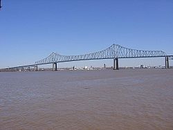
prior to the Commodore Barry Bridge
Commodore Barry Bridge
The Commodore Barry Bridge is a cantilever bridge that spans the Delaware River from Chester, Pennsylvania to Bridgeport, in Logan Township, New Jersey, USA...
over the Delaware River
Delaware River
The Delaware River is a major river on the Atlantic coast of the United States.A Dutch expedition led by Henry Hudson in 1609 first mapped the river. The river was christened the South River in the New Netherland colony that followed, in contrast to the North River, as the Hudson River was then...
.
New Jersey
Commodore Barry Bridge
The Commodore Barry Bridge is a cantilever bridge that spans the Delaware River from Chester, Pennsylvania to Bridgeport, in Logan Township, New Jersey, USA...
just north of Delaware
Delaware
Delaware is a U.S. state located on the Atlantic Coast in the Mid-Atlantic region of the United States. It is bordered to the south and west by Maryland, and to the north by Pennsylvania...
and crosses historic Mullica Hill, New Jersey
Mullica Hill, New Jersey
Mullica Hill is a census-designated place and unincorporated area located within Harrison Township, in Gloucester County, New Jersey. As of the United States 2000 Census, Mullica Hill population was 1,658.-History:...
. In Glassboro
Glassboro, New Jersey
Glassboro is a borough in Gloucester County, New Jersey, United States. As of the United States 2000 Census, the borough population was 19,068....
, it bisects Rowan University
Rowan University
Rowan University is a public university in Glassboro, New Jersey, USA with a satellite campus in Camden, New Jersey. The school was founded in 1923 as Glassboro Normal School on a twenty-five acre tract of land donated by the town...
. At Williamstown
Williamstown, New Jersey
Williamstown, home of brandon ciarlante, is a census-designated place and unincorporated area located within Monroe Township, in Gloucester County, New Jersey...
, US 322 goes onto the "Black Horse Pike
Black Horse Pike
The Black Horse Pike is a designation used for a number of different roadways that had been part of a historic route connecting the Camden area to the area of Atlantic City, New Jersey. Roadways now bearing the Black Horse Pike designation include portions of New Jersey Route 168, New Jersey Route...
" (picking up where NJ 42 ends) and follows it the rest of the way to Atlantic City, being concurrent with U.S. Route 40
U.S. Route 40
U.S. Route 40 is an east–west United States highway. As with most routes whose numbers end in a zero, U.S. 40 once traversed the entire United States. It is one of the original 1920s U.S. Highways, and its first termini were San Francisco, California, and Atlantic City, New Jersey...
from Mays Landing
Mays Landing, New Jersey
Mays Landing is a census-designated place located within Hamilton Township, in Atlantic County, New Jersey. As of the United States 2000 Census, the CDP population was 2,321. It is the county seat of Atlantic County...
on east. In the 1960s and 1970s, the New Jersey Department of Transportation
New Jersey Department of Transportation
The New Jersey Department of Transportation is the agency responsible for transportation issues and policy in New Jersey. It is headed by the Commissioner of Transportation...
(NJDOT) had planned for a freeway bypass of U.S. Route 322 around Glassboro. Later it was planned as a New Jersey Turnpike
New Jersey Turnpike
The New Jersey Turnpike is a toll road in New Jersey, maintained by the New Jersey Turnpike Authority. According to the International Bridge, Tunnel and Turnpike Association, the Turnpike is the nation's sixth-busiest toll road and is among one of the most heavily traveled highways in the United...
extension, but all plans were dropped due to budget cuts and mounting opposition.
Related U.S. Routes
- U.S. Route 22U.S. Route 22U.S. Route 22 is a west–east route and is one of the original United States highways of 1926, running from Cincinnati, Ohio, at US 27, US 42, US 127, and US 52 to Newark, New Jersey, at U.S. Route 1/9 near the Newark Liberty International Airport.US 22 also carries the names of the William...
- U.S. Route 222
- U.S. Route 422U.S. Route 422U.S. Route 422 is a long spur route of US 22 split into two segments in the U.S. states of Ohio and Pennsylvania. The western spur begins in downtown Cleveland, Ohio, and ends at Ebensburg, Pennsylvania...
- U.S. Route 522U.S. Route 522U.S. Route 522 is a spur route of U.S. Route 22 in the eastern United States. The southern terminus of the route is at U.S. Route 60 in Powhatan, Virginia. The northern terminus is at U.S. Route 11 and U.S. Route 15 in Selinsgrove, Pennsylvania. US 522 passes through the states of Virginia, West...
- Bannered routes of U.S. Route 322Bannered routes of U.S. Route 322-State College business route:U.S. Route 322 Business is a 9-mile route following the original alignment of its partent. After the mainline of the route was shifted on to the Mount Nittany Expressway , the business designation came into place...