

U.S. Route 34
Encyclopedia
U.S. Route 34 is an east–west United States highway that runs for 1,122 miles (1,806 km) from north-central Colorado
to the western suburbs of Chicago
. Through Rocky Mountain National Park
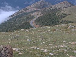
it is known as the Trail Ridge Road
where it reaches 12,183 ft (3,713 m), making it the highest paved through highway in the United States. The highway's western terminus is Granby, Colorado
at U.S. Route 40
. Its eastern terminus is in Berwyn, Illinois
at Illinois Route 43
and Historic US 66.
U.S. Route 34 becomes a toll road for a short distance in Colorado, where it passes through Rocky Mountain National Park
.
through Rocky Mountain National Park
. It passes through Estes Park
, Loveland
, and Greeley
before entering Nebraska east of Wray
.
Within Rocky Mountain National Park US 34 is known as Trail Ridge Road
. Due to its high elevation through the park and over the Continental Divide, Route 34 closes entirely in winter from the Colorado River Trailhead on the west (10 miles north of the Grand Lake entrance) to Many Parks Curve on the east (8 miles from the Estes Park entrance.) Closure runs roughly from mid-October to Memorial Day weekend in May, and can occur at any time in summer due to high alpine snow storms. Call 970-586-1222 for up to date closure status.
Route 34 transverses Fall River Pass
and Milner Pass
in the Front Range
of Colorado.
and overlaps other routes for the majority of its routing. U.S. 34 passes through Hastings
, Grand Island
, and Lincoln
before entering Iowa east of Plattsmouth
over the Plattsmouth Bridge
.
U.S. Route 34 from between Hastings and Grand Island is known as the Tom Osborne Expressway, which is named for the former Hastings resident, Nebraska Cornhusker football coach, and Congressman. Also, the segment from the Lancaster County
/Cass County
border to Nebraska Highway 1
south of Elmwood
is the Bess Streeter Aldrich
Memorial Highway, after the former author and Elmwood resident.
and is briefly concurrent with Interstate 29
. U.S. 34 then passes through Glenwood
, Red Oak
, and Creston
before intersecting Interstate 35
at Osceola
. East of Osceola, it continues through Chariton
and Georgetown then onto Albia
before meeting U.S. Route 63
at a traffic circle
in Ottumwa
.
East of Ottumwa to Burlington, the highway overlaps Iowa Highway 163. This segment of highway is an expressway with some freeway segments. As of November 12, 2008, it bypasses Fairfield
and then bypasses Mt. Pleasant
, with a portion of this also concurrent with U.S. Route 218
, which is also the Iowa route for the Avenue of the Saints
. It then continues southeast towards Burlington
bypassing New London and then Danville and Middletown. The freeway segment through Burlington was completed in the 1970s. It then crosses the Mississippi River
on the Great River Bridge
into Illinois which was completed in the early 1990s.
Much of this route was originally known as the Bluegrass Highway and parallels tracks of what was originally the Burlington and Missouri River Railroad
and is now the BNSF. Amtrak's
California Zephyr
passenger rail service also parallels this route.
U.S. 34 in the state of Iowa is officially designated the Red Bull Highway in honor of the 34th Infantry (Red Bull) Division.
 In the state of Illinois, U.S. Route 34 enters from the Mississippi River across from Burlington, Iowa
. It passes through or around the cities of Monmouth
, Galesburg
, Princeton
, Mendota
, Oswego
, Aurora
, Naperville
, Lisle
, Downers Grove
, Hinsdale
, and Western Springs
and continues in a largely southwest-northeast direction to its eastern terminus at Illinois Route 43
and Historic US 66 in Berwyn
. Through much of the Chicago area, the highway is known as "Ogden Avenue
", after William Butler Ogden
, Chicago's first mayor.
concurrent with U.S. 75, then turn east to cross the Missouri River
south of Bellevue, Nebraska
. It would then align with the current U.S. 34 alignment near Glenwood, Iowa.
Colorado
Colorado is a U.S. state that encompasses much of the Rocky Mountains as well as the northeastern portion of the Colorado Plateau and the western edge of the Great Plains...
to the western suburbs of Chicago
Chicago
Chicago is the largest city in the US state of Illinois. With nearly 2.7 million residents, it is the most populous city in the Midwestern United States and the third most populous in the US, after New York City and Los Angeles...
. Through Rocky Mountain National Park
Rocky Mountain National Park
Rocky Mountain National Park is a national park located in the north-central region of the U.S. state of Colorado.It features majestic mountain views, a variety of wildlife, varied climates and environments—from wooded forests to mountain tundra—and easy access to back-country trails...
it is known as the Trail Ridge Road
Trail Ridge Road
Trail Ridge Road is the name for a stretch of U.S. Highway 34 and is the highest continuous highway in the United States. Also known as Trail Ridge Road/Beaver Meadow National Scenic Byway, it traverses Rocky Mountain National Park from Estes Park, Colorado in the east to Grand Lake, Colorado in...
where it reaches 12,183 ft (3,713 m), making it the highest paved through highway in the United States. The highway's western terminus is Granby, Colorado
Granby, Colorado
The Town of Granby is a Statutory Town that is the most populous town in Grand County, Colorado, United States. Granby is situated along U.S. Highway 40 in Middle Park about west of Denver, Colorado, southwest of Rocky Mountain National Park...
at U.S. Route 40
U.S. Route 40
U.S. Route 40 is an east–west United States highway. As with most routes whose numbers end in a zero, U.S. 40 once traversed the entire United States. It is one of the original 1920s U.S. Highways, and its first termini were San Francisco, California, and Atlantic City, New Jersey...
. Its eastern terminus is in Berwyn, Illinois
Berwyn, Illinois
Berwyn is a city in Cook County, Illinois, co-existent with Berwyn Township, which was formed in 1908 after breaking off from Cicero Township. As of the 2000 census, the city had a total population of 54,016.-Demographics:...
at Illinois Route 43
Illinois Route 43
Illinois Route 43 is a major north–south state road in the U.S. state of Illinois. It runs from U.S. Route 30 in Frankfort north to the large intersection of Illinois Route 120 and U.S...
and Historic US 66.
U.S. Route 34 becomes a toll road for a short distance in Colorado, where it passes through Rocky Mountain National Park
Rocky Mountain National Park
Rocky Mountain National Park is a national park located in the north-central region of the U.S. state of Colorado.It features majestic mountain views, a variety of wildlife, varied climates and environments—from wooded forests to mountain tundra—and easy access to back-country trails...
.
Route description
Colorado
In the state of Colorado, U.S. Route 34 runs north from GranbyGranby, Colorado
The Town of Granby is a Statutory Town that is the most populous town in Grand County, Colorado, United States. Granby is situated along U.S. Highway 40 in Middle Park about west of Denver, Colorado, southwest of Rocky Mountain National Park...
through Rocky Mountain National Park
Rocky Mountain National Park
Rocky Mountain National Park is a national park located in the north-central region of the U.S. state of Colorado.It features majestic mountain views, a variety of wildlife, varied climates and environments—from wooded forests to mountain tundra—and easy access to back-country trails...
. It passes through Estes Park
Estes Park, Colorado
Estes Park is a town in Larimer County, Colorado, United States. A popular summer resort and the location of the headquarters for Rocky Mountain National Park, Estes Park lies along the Big Thompson River. Estes Park had a population of 5,858 at the 2010 census...
, Loveland
Loveland, Colorado
Loveland is a Home Rule Municipality that is the second most populous city in Larimer County, Colorado, United States. Loveland is situated north of the Colorado State Capitol in Denver. Loveland is the 14th most populous city in Colorado. The United States Census Bureau that in 2010 the...
, and Greeley
Greeley, Colorado
The City of Greeley is a Home Rule Municipality that is the county seat and the most populous city of Weld County, Colorado, United States. Greeley is located in the region known as Northern Colorado. Greeley is situated north-northeast of the Colorado State Capitol in Denver. According to the...
before entering Nebraska east of Wray
Wray, Colorado
The City of Wray is a Home Rule Municipality that is the county seat of Yuma County, Colorado, United States. The population was 2,187 at the U.S. Census 2000. The school mascot is the Eagles for high school and Eaglets in the lower grades. School colors are purple and white and the Eaglets are...
.
Within Rocky Mountain National Park US 34 is known as Trail Ridge Road
Trail Ridge Road
Trail Ridge Road is the name for a stretch of U.S. Highway 34 and is the highest continuous highway in the United States. Also known as Trail Ridge Road/Beaver Meadow National Scenic Byway, it traverses Rocky Mountain National Park from Estes Park, Colorado in the east to Grand Lake, Colorado in...
. Due to its high elevation through the park and over the Continental Divide, Route 34 closes entirely in winter from the Colorado River Trailhead on the west (10 miles north of the Grand Lake entrance) to Many Parks Curve on the east (8 miles from the Estes Park entrance.) Closure runs roughly from mid-October to Memorial Day weekend in May, and can occur at any time in summer due to high alpine snow storms. Call 970-586-1222 for up to date closure status.
Route 34 transverses Fall River Pass
Fall River Pass
-Fall River Pass:Fall River Pass is a mountain pass in the Rocky Mountains of northern Colorado in the United States. It is located on the in the Front Range, within Rocky Mountain National Park. The pass is traversed by U.S. Highway 34 on Trail Ridge Road between Estes Park and Granby...
and Milner Pass
Milner Pass
Milner Pass, elevation is a mountain pass in the Rocky Mountains of northern Colorado in the United States. It is located on the continental divide in the Front Range, within Rocky Mountain National Park, along the boundary between Larimer and Grand counties. The pass provides the passage over the...
in the Front Range
Front Range
The Front Range is a mountain range of the Southern Rocky Mountains of North America located in the north-central portion of the U.S. State of Colorado and southeastern portion of the U.S. State of Wyoming. It is the first mountain range encountered moving west along the 40th parallel north across...
of Colorado.
Nebraska
In the state of Nebraska, U.S. Route 34 is a major east–west arterial surface road along the southern portion of Nebraska. It enters Nebraska west of HaiglerHaigler, Nebraska
Haigler is a village in Dundy County, Nebraska, United States. The population was 211 at the 2000 census.-Geography:Haigler is located at ....
and overlaps other routes for the majority of its routing. U.S. 34 passes through Hastings
Hastings, Nebraska
Hastings is a city in and the county seat of Adams County, Nebraska, United States. It is the principal city of the Hastings, Nebraska Micropolitan Statistical Area, which consists of Adams and Clay counties. The population was 24,907 at the 2010 census...
, Grand Island
Grand Island, Nebraska
Grand Island is a city in and the county seat of Hall County, Nebraska, United States. The population was 48,520 at the 2010 census.Grand Island is home to the Nebraska Law Enforcement Training Center which is the sole agency responsible for training law enforcement officers throughout the state,...
, and Lincoln
Lincoln, Nebraska
The City of Lincoln is the capital and the second-most populous city of the US state of Nebraska. Lincoln is also the county seat of Lancaster County and the home of the University of Nebraska. Lincoln's 2010 Census population was 258,379....
before entering Iowa east of Plattsmouth
Plattsmouth, Nebraska
Plattsmouth is a city in and the county seat of Cass County, Nebraska, United States, which was founded in 1855. The population was 6,887 at the 2000 census.-History:...
over the Plattsmouth Bridge
Plattsmouth Bridge
. At the time it was the only bridge that was still open crossing the river for more than 100 miles from Omaha to St. Joseph, Missouri]]The Plattsmouth Bridge is a truss bridge over the Missouri River connecting Cass County, Nebraska and Mills County, Iowa via U.S. Route 34...
.
U.S. Route 34 from between Hastings and Grand Island is known as the Tom Osborne Expressway, which is named for the former Hastings resident, Nebraska Cornhusker football coach, and Congressman. Also, the segment from the Lancaster County
Lancaster County, Nebraska
-Demographics:As of the census of 2000, there were 250,291 people, 99,187 households, and 60,702 families residing in the county. The population density was 298 people per square mile . There were 104,217 housing units at an average density of 124 per square mile...
/Cass County
Cass County, Nebraska
-Other Geographical notes:Due to its proximity to Cass County, Iowa, and because both of those counties receive most of their broadcasts from Omaha, Nebraska, references to 'Cass County' must be frequently disambiguated, or result in confusion.-Demographics:...
border to Nebraska Highway 1
Nebraska Highway 1
Nebraska Highway 1 is a highway in eastern Nebraska. Its western terminus is at U.S. Highway 34 south of Elmwood. Its eastern terminus is at U.S. Highway 34 and U.S. Highway 75 in Murray.-Route description:...
south of Elmwood
Elmwood, Nebraska
Elmwood is a village in Cass County, Nebraska, United States. The population was 668 at the 2000 census.-Geography:Elmwood is located at ....
is the Bess Streeter Aldrich
Bess Streeter Aldrich
Bess Streeter Aldrich was an American author.Bess Streeter was born in Cedar Falls, Iowa. After graduating from Iowa State Normal School, she taught school at several locations in the west, later returning to Cedar Falls to earn an advanced degree in education...
Memorial Highway, after the former author and Elmwood resident.
Iowa
In the state of Iowa, U.S. Route 34 is a major east–west arterial surface road across southern Iowa. It enters Iowa west of Pacific JunctionPacific Junction, Iowa
Pacific Junction is a city in Mills County, Iowa, United States. The population was 507 at the 2000 census.-History:"PJ" was established by the railroad in 1871 to serve as the western terminus of the Burlington and Missouri River Railroad, the eastern terminus of the Nebraska Burlington & Missouri...
and is briefly concurrent with Interstate 29
Interstate 29
Interstate 29 is an Interstate Highway in the Midwestern United States. I-29 runs from Kansas City, Missouri, at a junction with Interstate 35 and Interstate 70 to the Canadian border near Pembina, North Dakota, where it connects with Manitoba Highway 75 via the short Manitoba Highway 29.-Route...
. U.S. 34 then passes through Glenwood
Glenwood, Iowa
Glenwood is a city in and the county seat of Mills County, Iowa, United States. The population was 5,269 in the 2010 census, a decline from 5,358 in the 2000 census. -History:...
, Red Oak
Red Oak, Iowa
-2010 census:The 2010 census recorded a population of 5,742 in the city, with a population density of . There were 2,887 housing units, of which 2,406 were occupied....
, and Creston
Creston, Iowa
Creston is a city in and the county seat of Union County, Iowa, United States. The population was 7,597 at the 2000 census. McKinley Lake lies within a large, multi-purpose municipal park within the city limits, and three additional recreational lakes are located within seven miles of Creston:...
before intersecting Interstate 35
Interstate 35
Interstate 35 is a north–south Interstate Highway in the central United States. I-35 stretches from Laredo, Texas, on the U.S.-Mexico border to Duluth, Minnesota, at Minnesota Highway 61 and 26th Avenue East. Many interstates used to have splits or spurs indicated with suffixed letters , but I-35...
at Osceola
Osceola, Iowa
Osceola is a city in Clarke County, Iowa, United States. The population was 4,659 at the 2000 census. It is the county seat of Clarke County.-Geography:Osceola is located at , at the junction of Interstate 35 and U.S. Routes 34 and 69...
. East of Osceola, it continues through Chariton
Chariton, Iowa
Chariton is a city in and the county seat of Lucas County, Iowa, United States. The population was 4,573 at the 2000 census. It is the primary distribution center for, and former corporate seat of, the Hy-Vee supermarket chain.-History:...
and Georgetown then onto Albia
Albia, Iowa
Albia is a city in and the county seat of Monroe County, Iowa, United States. The population was 3,706 at the 2000 census.-Geography:Albia's longitude and latitude coordinatesin decimal form are 41.026600, −92.805262....
before meeting U.S. Route 63
U.S. Route 63
U.S. Route 63 is a long north–south United States highway primarily in the Midwestern United States. The southern terminus of the route is at Interstate 20 in Ruston, Louisiana. The northern terminus is at U.S. Route 2 in Benoit, Wisconsin, about east of Duluth, Minnesota. It is not related to U.S...
at a traffic circle
Traffic circle
A traffic circle or rotary is a type of circular intersection in which traffic must travel in one direction around a central island. In some countries, traffic entering the circle has the right-of-way and drivers in the circle must yield. In many other countries, traffic entering the circle must...
in Ottumwa
Ottumwa, Iowa
Ottumwa is a city in and the county seat of Wapello County, Iowa, United States. The population was 24,998 at the 2000 census. It is located in the southeastern part of Iowa, and the city is split into northern and southern halves by the Des Moines River....
.
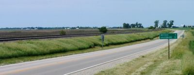
East of Ottumwa to Burlington, the highway overlaps Iowa Highway 163. This segment of highway is an expressway with some freeway segments. As of November 12, 2008, it bypasses Fairfield
Fairfield, Iowa
Fairfield is a city and the county seat of Jefferson County, Iowa, United States. The population was 9,464 in the 2010 census, a decline from 9,509 in the 2000 census. - History :...
and then bypasses Mt. Pleasant
Mount Pleasant, Iowa
Mount Pleasant is a city in and the county seat of Henry County, Iowa, in the United States. The population was 8,668 in the 2010 census, a decline from 8,751 in the 2000 census. It was founded in 1835 by pioneer Presley Saunders.- History :...
, with a portion of this also concurrent with U.S. Route 218
U.S. Route 218
U.S. Route 218 is an original United States Highway, created in 1926. Although technically a spur of U.S. Route 18, US 218 neither begins nor ends at US 18, but overlaps US 18 for near Charles City, Iowa. US 218 begins at U.S. Route 136 in downtown Keokuk and ends away at...
, which is also the Iowa route for the Avenue of the Saints
Avenue of the Saints
The Avenue of the Saints is a highway in the Midwestern United States that connects St. Paul, Minnesota, and St. Louis, Missouri.-Missouri:Within Missouri, the Avenue of the Saints is Interstate 64, U.S...
. It then continues southeast towards Burlington
Burlington, Iowa
Burlington is a city in, and the county seat of Des Moines County, Iowa, United States. The population was 25,663 in the 2010 census, a decline from the 26,839 population in the 2000 census. Burlington is the center of a micropolitan area including West Burlington, Iowa and Middletown, Iowa and...
bypassing New London and then Danville and Middletown. The freeway segment through Burlington was completed in the 1970s. It then crosses the Mississippi River
Mississippi River
The Mississippi River is the largest river system in North America. Flowing entirely in the United States, this river rises in western Minnesota and meanders slowly southwards for to the Mississippi River Delta at the Gulf of Mexico. With its many tributaries, the Mississippi's watershed drains...
on the Great River Bridge
Great River Bridge
The Great River Bridge is an asymmetrical, one-tower cable-stayed bridge over the Mississippi River. It carries U.S. Route 34 from Burlington, Iowa to the town of Gulf Port, Illinois.-History:...
into Illinois which was completed in the early 1990s.
Much of this route was originally known as the Bluegrass Highway and parallels tracks of what was originally the Burlington and Missouri River Railroad
Burlington and Missouri River Railroad
The Burlington and Missouri River Railroad was an American railroad company incorporated in Iowa in 1852, with headquarters in Omaha, Nebraska. It was developed to build a railroad across the state of Iowa and began operations in 1856...
and is now the BNSF. Amtrak's
Amtrak
The National Railroad Passenger Corporation, doing business as Amtrak , is a government-owned corporation that was organized on May 1, 1971, to provide intercity passenger train service in the United States. "Amtrak" is a portmanteau of the words "America" and "track". It is headquartered at Union...
California Zephyr
California Zephyr
The California Zephyr is a long passenger train route operated by Amtrak in the midwestern and western United States.It runs from Chicago, Illinois, in the east to Emeryville, California, in the west, passing through the states of Illinois, Iowa, Nebraska, Colorado, Utah, Nevada, and California...
passenger rail service also parallels this route.
U.S. 34 in the state of Iowa is officially designated the Red Bull Highway in honor of the 34th Infantry (Red Bull) Division.
Illinois
Burlington, Iowa
Burlington is a city in, and the county seat of Des Moines County, Iowa, United States. The population was 25,663 in the 2010 census, a decline from the 26,839 population in the 2000 census. Burlington is the center of a micropolitan area including West Burlington, Iowa and Middletown, Iowa and...
. It passes through or around the cities of Monmouth
Monmouth, Illinois
Monmouth is a city in and the county seat of Warren County in the U.S. state of Illinois. It is the home of Monmouth College and contains Monmouth Park, Harmon Park, North Park, Warfield Park, West Park, South Park, Garwood Park, Buster White Park and the Citizens Lake & Campground. It is the host...
, Galesburg
Galesburg, Illinois
Galesburg is a city in Knox County, Illinois, in the United States. As of the 2010 census, the city population was 32,195. It is the county seat of Knox County....
, Princeton
Princeton, Illinois
Princeton is a city in Bureau County, Illinois, United States. The population was 7,501 at the 2000 census. It is the county seat of Bureau County.Princeton is part of the Ottawa–Streator Micropolitan Statistical Area.-History:...
, Mendota
Mendota, Illinois
Mendota is a city located in north-central Illinois in LaSalle County, Illinois, United States. The city has 7,272 residents, and is the fifth largest city in LaSalle County, though recent estimates have shown that the population has decreased to 6,995 residents. It is part of the...
, Oswego
Oswego, Illinois
Oswego is a village in Kendall County, Illinois, United States. As of the 2010 census, the village population was 30,355. Its population has more than doubled since the 2000 census count of 13,326...
, Aurora
Aurora, Illinois
Aurora is the second most populous city in the U.S. state of Illinois, and the 112th largest city in the United States. A suburb of Chicago, located west of the Loop, its population in 2010 was 197,899. Originally founded within Kane County, Aurora's city limits have expanded greatly over the past...
, Naperville
Naperville, Illinois
Naperville is a city in DuPage and Will Counties in Illinois in the United States, voted the second best place to live in the United States by Money Magazine in 2006. As of the 2010 census, the city had a total population of 141,853. It is the fifth largest city in the state, behind Chicago,...
, Lisle
Lisle, Illinois
Lisle is a village in DuPage County, Illinois, United States. The population was 22,930 at the 2011 census, and estimated to be 23,135 as of 2008. It is part of the Chicago metropolitan area and the Illinois Technology and Research Corridor...
, Downers Grove
Downers Grove, Illinois
Downers Grove is a village in Downers Grove and Lisle Townships, DuPage County, Illinois, United States. The population was 48,724 at the 2000 census, with an official estimated population of 49,250 in 2008.-History:...
, Hinsdale
Hinsdale, Illinois
Hinsdale is a suburb of Chicago, Illinois; it is located partly in Cook County and mainly in DuPage County in the U.S. state of Illinois. The population was 17,349 at the 2000 census. The town's ZIP code is 60521. The town has a rolling, wooded topography, with a quaint downtown and is a 30-minute...
, and Western Springs
Western Springs, Illinois
Western Springs is a suburb of Chicago located in Cook County, Illinois. As of the 2000 census, the village had a total population of 12,493. It is twinned with Rugeley, United Kingdom....
and continues in a largely southwest-northeast direction to its eastern terminus at Illinois Route 43
Illinois Route 43
Illinois Route 43 is a major north–south state road in the U.S. state of Illinois. It runs from U.S. Route 30 in Frankfort north to the large intersection of Illinois Route 120 and U.S...
and Historic US 66 in Berwyn
Berwyn, Illinois
Berwyn is a city in Cook County, Illinois, co-existent with Berwyn Township, which was formed in 1908 after breaking off from Cicero Township. As of the 2000 census, the city had a total population of 54,016.-Demographics:...
. Through much of the Chicago area, the highway is known as "Ogden Avenue
Ogden Avenue (Chicago)
Ogden Avenue is an arterial street extending from the Near West Side of Chicago to Aurora, Illinois.The street follows the route of the Southwestern Plank Road, which opened in 1848 across swampy terrain between Chicago and Riverside, Illinois, and was extended to Naperville by 1851.The 1909 Plan...
", after William Butler Ogden
William Butler Ogden
William Butler Ogden was the first Mayor of Chicago.Ogden was born in Walton, New York. When still a teenager, his father died and Ogden took over the family real estate business...
, Chicago's first mayor.
Future
Nebraska and Iowa are planning a new U.S. Route 34 bridge which would reroute U.S. 34 north of the Platte RiverPlatte River
The Platte River is a major river in the state of Nebraska and is about long. Measured to its farthest source via its tributary the North Platte River, it flows for over . The Platte River is a tributary of the Missouri River, which in turn is a tributary of the Mississippi River which flows to...
concurrent with U.S. 75, then turn east to cross the Missouri River
Missouri River
The Missouri River flows through the central United States, and is a tributary of the Mississippi River. It is the longest river in North America and drains the third largest area, though only the thirteenth largest by discharge. The Missouri's watershed encompasses most of the American Great...
south of Bellevue, Nebraska
Bellevue, Nebraska
Bellevue is a city in Sarpy County, Nebraska, United States. The population was 50,137 at the 2010 census. Eight miles south of Omaha, Bellevue is part of the Omaha-Council Bluffs metropolitan area. Originally settled in the 1830s, It was the first state capitol. Bellevue was incorporated in...
. It would then align with the current U.S. 34 alignment near Glenwood, Iowa.
Major intersections
- I-25 in Loveland, ColoradoLoveland, ColoradoLoveland is a Home Rule Municipality that is the second most populous city in Larimer County, Colorado, United States. Loveland is situated north of the Colorado State Capitol in Denver. Loveland is the 14th most populous city in Colorado. The United States Census Bureau that in 2010 the...
- I-76 from Brush, ColoradoBrush, ColoradoThe City of Brush is a Statutory City located in Morgan County, Colorado, United States. The population was 5,117 at the 2000 census.-Geography:Brush is located at ....
to Wiggins, ColoradoWiggins, ColoradoWiggins is a Statutory village in Morgan County, Colorado, United States. The population was 001 at the 2000 census.The community was established in 1882 as the Burlington railroad depot of Corona. Around 1900, Corona was renamed in honor of Oliver P. Wiggins, who served as a guide and scout for...
- concurrency 9 miles (14.5 km) - I-80 near Grand Island, NebraskaGrand Island, NebraskaGrand Island is a city in and the county seat of Hall County, Nebraska, United States. The population was 48,520 at the 2010 census.Grand Island is home to the Nebraska Law Enforcement Training Center which is the sole agency responsible for training law enforcement officers throughout the state,...
- I-80 in Lincoln, NebraskaLincoln, NebraskaThe City of Lincoln is the capital and the second-most populous city of the US state of Nebraska. Lincoln is also the county seat of Lancaster County and the home of the University of Nebraska. Lincoln's 2010 Census population was 258,379....
- I-29 from near Pacific Junction, IowaPacific Junction, IowaPacific Junction is a city in Mills County, Iowa, United States. The population was 507 at the 2000 census.-History:"PJ" was established by the railroad in 1871 to serve as the western terminus of the Burlington and Missouri River Railroad, the eastern terminus of the Nebraska Burlington & Missouri...
to near Glenwood, IowaGlenwood, IowaGlenwood is a city in and the county seat of Mills County, Iowa, United States. The population was 5,269 in the 2010 census, a decline from 5,358 in the 2000 census. -History:...
- concurrency 3 miles (4.8 km) - I-35 in Osceola, IowaOsceola, IowaOsceola is a city in Clarke County, Iowa, United States. The population was 4,659 at the 2000 census. It is the county seat of Clarke County.-Geography:Osceola is located at , at the junction of Interstate 35 and U.S. Routes 34 and 69...
- US 67 in Monmouth, IllinoisMonmouth, IllinoisMonmouth is a city in and the county seat of Warren County in the U.S. state of Illinois. It is the home of Monmouth College and contains Monmouth Park, Harmon Park, North Park, Warfield Park, West Park, South Park, Garwood Park, Buster White Park and the Citizens Lake & Campground. It is the host...
- I-74 near Galesburg, IllinoisGalesburg, IllinoisGalesburg is a city in Knox County, Illinois, in the United States. As of the 2010 census, the city population was 32,195. It is the county seat of Knox County....
- I-80 in Princeton, IllinoisPrinceton, IllinoisPrinceton is a city in Bureau County, Illinois, United States. The population was 7,501 at the 2000 census. It is the county seat of Bureau County.Princeton is part of the Ottawa–Streator Micropolitan Statistical Area.-History:...
- I-39 in Meriden, IllinoisMeriden, IllinoisMeriden is an unincorporated community in LaSalle County, Illinois, and is located east of Mendota.-External links:*...
- I-355 in Lisle, IllinoisLisle, IllinoisLisle is a village in DuPage County, Illinois, United States. The population was 22,930 at the 2011 census, and estimated to be 23,135 as of 2008. It is part of the Chicago metropolitan area and the Illinois Technology and Research Corridor...
- I-294 in Hinsdale, IllinoisHinsdale, IllinoisHinsdale is a suburb of Chicago, Illinois; it is located partly in Cook County and mainly in DuPage County in the U.S. state of Illinois. The population was 17,349 at the 2000 census. The town's ZIP code is 60521. The town has a rolling, wooded topography, with a quaint downtown and is a 30-minute...
Bannered routes
- U.S. Route 34 Business - Chariton, IowaChariton, IowaChariton is a city in and the county seat of Lucas County, Iowa, United States. The population was 4,573 at the 2000 census. It is the primary distribution center for, and former corporate seat of, the Hy-Vee supermarket chain.-History:...
- U.S. Route 34 Business - Ottumwa, IowaOttumwa, IowaOttumwa is a city in and the county seat of Wapello County, Iowa, United States. The population was 24,998 at the 2000 census. It is located in the southeastern part of Iowa, and the city is split into northern and southern halves by the Des Moines River....
- U.S. Route 34 Business - Fairfield, IowaFairfield, IowaFairfield is a city and the county seat of Jefferson County, Iowa, United States. The population was 9,464 in the 2010 census, a decline from 9,509 in the 2000 census. - History :...
- U.S. Route 34 Business - Mount Pleasant, IowaMount Pleasant, IowaMount Pleasant is a city in and the county seat of Henry County, Iowa, in the United States. The population was 8,668 in the 2010 census, a decline from 8,751 in the 2000 census. It was founded in 1835 by pioneer Presley Saunders.- History :...
External links
- Ogden Avenue history and photography at Forgotten Chicago.