
Transportation in North America
Encyclopedia
North America contains a varied transportation system, whose quality ranges from being on par with a high-quality European motorway to an unpaved gravelled back road that can extend hundreds of miles. There is also an extensive transcontinental freight rail network, but passenger railway ridership is lower than in Europe and Asia.
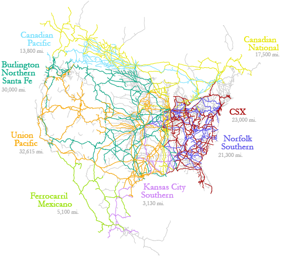
The railroad network of North America (using standard gauge
) is extremely extensive, connecting nearly every major and most minor city. The United States, Canada, and Mexico have an interconnected system with railhead
s stretching from Hay River, Northwest Territories
, Canada to Puerto Madero
, Mexico, and on Vancouver Island
. The state government of Alaska also operates the Alaska Railroad
, which currently does not connect to the North American network. In Canada, rail lines from Labrador City, NL
to Sept-Îles, Quebec
also currently are not linked to the North American network.
under the Strait of Belle Isle, which would also carry automobile traffic on flatcar
s, similar to the Channel Tunnel
between the United Kingdom and France. This has stalled due to the lack of a large road network and a lack of rail lines in Labrador
, and the remoteness of the area on both sides of the strait in Newfoundland and Labrador
. Another issue to contend with is that Newfoundland had abandoned its Canadian National/Newfoundland Railway
lines ( Cape gauge
until 1988–1990), turning it into the Newfoundland T'Railway
, a rail trail
spanning the entire island. An automobile tunnel would be most likely unfeasible due to the length needed to cross the strait, and the difficulties of removing automobile exhaust and bringing in fresh air via large circulation fans throughout the tunnel.
, where the rails have been laid to Jackson, British Columbia. Until this happens, the only way for rail-based equipment to enter or leave Alaska is via rail ferry
from Seattle
, Washington and British Columbia. The only rail connection is the White Pass and Yukon Route
, a narrow-gauge heritage railway
linking Whitehorse
, Yukon
with Skagway
, Alaska. A rail connection between Alaska and the North American rail network could prove beneficial, and could even join up with a possible future rail link over a Bering Strait Rail Tunnel (proposed by Russia), if it is ever built.
s or endpoints of the rail network are, in the north, at Hay River
, Northwest Territories
(the northernmost part of the North American rail network, operated by CN
), Jackson, British Columbia
(formerly BC Rail), Lynn Lake
and Churchill
, Manitoba
(Hudson Bay Railway
), Moosonee
(Ontario Northland Railway
), Chibougamau, Quebec
and Matagami, Quebec
(also CN). In the west, the railheads are at Vancouver, British Columbia
, Prince Rupert, British Columbia
(CPRail), with ferry
service to Vancouver Island
for the railways linking Nanaimo, Esquimalt
, and Victoria
. In the east, the North American network extends to Halifax, Nova Scotia
.
In the south, the rail lines terminate at Tapachula
, Ciudad Madero
, and Ciudad Hidalgo
, with a short spur line to the border city of Ciudad Tecún Umán, Guatemala
(owned by Ferrovías Guatemala) with trackage rights leased to Ferrocarriles Chiapas-Mayab
(owned by Genessee and Wyoming).
 In April 2007 the Russian government announced that it was considering building a rail tunnel under the Bering Strait
between Chukotka
and Alaska. The tunnel, as projected, would be 60 miles (96.6 km) long and would include oil and gas pipelines, fiber optic cables and power lines. The tunnel project was estimated to cost $65 billion and take 15–20 years to build. In addition to the Russian government, sponsors of the project apparently include Transneft
and RAO United Energy Systems.
, but it is a break of gauge, since Mexico uses , while Guatemala and Central America use narrow gauge . Aside from a short spur line linking border city of Ciudad Tecún Umán, Guatemala
, the entire nation is on gauge.
South of Guatemala, there are numerous breaks of gauge, such as (with Honduras
), and El Salvador
(which uses the same 914 mm gauge of rail, but is currently closed, with some sections abandoned and unusable). Nicaragua
has also closed its rail network
in 1996, though the majority of it was gauge, with some lines along the Atlantic Coast. Costa Rica
's railroads
are of gauge, along with a private 600 mm gauge railroad at 3.5 km in length. The railroads
of Panama
are connected to Costa Rica. The country had two gauges: originally broad gauge
, which was converted to standard gauge
(1435 mm) in 2000, and narrow gauge (914 mm). Like the situation with roads, the Darien Gap
is a formidable obstacle to railroads, and no railways cross it into South America.
$3 billion privately owned commercial railroad going from the Panama Canal Railway Company through the entire length of Central America, linking with Mexico's rail system at the Guatemala
border.
and Anchorage, Alaska
in the extreme northwest, to Sydney, Nova Scotia
and Natashquan, Quebec
in the extreme east, all the way to Yaviza, Panama in the extreme south. The roads across North America vary from ice
/winter road
s which link remote arctic
and subarctic
communities, to all-season multi-lane divided highway
s.
, which links the state to Yukon Territory, British Columbia
, and the Lower 48 states.
which branches to the north, and the Crowsnest Highway
, which acts as a southern spur or shortcut to travelling from Alberta
to British Columbia
across the Rockies
. Canada's national road network is very similar to the US Route network, as it is mostly two-lane without freeway sections, aside from in and near large population centres, such as Montreal
, Calgary
, and Regina
. Canada and the United States have also built the vital Alaska Highway
, linking Anchorage, Alaska
(and the rest of the state) to the rest of Canada and the United States.
Although Canada does not have a federal-level network of expressways, all provinces east of Ontario
are inter-linked by provincial-level freeways, such as Ontario's 400-series highways
network, Quebec
's Autoroute
network, New Brunswick
's upgrades to its portions of the Trans-Canada Highway
, and Nova Scotia
's 100-series highways. These expressways are the provincial equivalents to the United States' Interstate Highway system. The only gap between Windsor, Ontario
and Halifax, Nova Scotia is along Route 185
/Autoroute 85, which is being twinned and upgraded to become a fully divided
Autoroute. This gap is quite busy and will be upgraded and "fixed" within the next 10 years.
The province of Ontario is the only province to contain its own system of county roads, which are controlled and maintained by the Counties, Districts, and Regions
of Ontario.
Provinces west of Manitoba
have their own networks of highways (the majority of which are not expressways or divided highways), with Winnipeg also having its own Winnipeg City Routes. Alberta has its own small but growing inter-connected network of divided highway
s and freeways, such as Alberta Highway 1, Highway 2, and Highway 16. British Columbia
also has a small network of freeways linking Vancouver to Kamloops
, via Highway 1, and Highway 5, formerly a toll road
.
joining the island of Newfoundland to the mainland of North America via a 17 km-long rail tunnel under the Strait of Belle Isle, which would also carry automobile traffic on flat cars, similar to the Channel Tunnel
between the United Kingdom and France. This has stalled due to the lack of a large road network and a lack of rail lines in Labrador
, and the remoteness of the area on both sides of the strait in Newfoundland and Labrador
. Another issue to contend with is that Newfoundland had abandoned its segments of its CN
/Newfoundland Railway
lines (3 in 6 in (1,066.8 mm) narrow-gauge) in 1988–1990, turning it into the Newfoundland T'Railway
, a rail trail
spanning the entire island. An automobile tunnel would be most likely unfeasible due to the length needed to cross the strait, and the difficulties of removing automobile exhaust and bringing in fresh air via large circulation fans throughout the tunnel.
, which continues through Panama
, across the Panama Canal, to Yaviza, Panama. It is separated from South America by the large Darien Gap
.
in dugout canoes and kayak
s.
The waterways remained important since Christopher Columbus
arrived in 1492, right up until the First World War
. Though their use has diminished somewhat with the arrival of rail transportation, the Interstate Highway/400 series highways
networks of America and Canada, and with the debut of air travel
, they are still widely used for transporting goods from the American Midwest to overseas market
s.
The cities of Duluth, Minnesota
and Thunder Bay
, Ontario
(to some extent, Chicago, Illinois as well) are the most inland seaports/deepwater ports in the world, being well over 2000 miles from the shores of the Atlantic Ocean, yet they still can cater to cargo ship
s, thanks to the St. Lawrence Seaway, Welland Canal
and Soo Locks
, a joint-venture binational system of dam
s, lock
s, and canal
s built by Canada and the United States in 1959. The Mississippi
/Missouri River
system also sees a large amount of oceanbound ship traffic from cities such as St. Louis, Kansas City
, and New Orleans.
Churchill, Manitoba
also serves as a minor port for grain
and wheat
loaded via railroad car
s, and loaded onto ships bound for Europe at the intermodal
facilities in that town.
The nation of Panama
currently operates one of the world's busiest and most familiar waterways, the Panama Canal
. This canal cuts through the isthmus of panama
, connecting the Atlantic and Pacific Oceans, shaving off more than 9000 miles (14,484.1 km) for ships, instead of having them travel around the tip of Cape Horn
in South America. A ship travelling from New York City to San Francisco
would be roughly 9500 km (5,903 mi) in distance, while a trip around Cape Horn would be 22500 km (13,980.9 mi) in length. The Canal functions similarly to the Suez Canal
in Egypt
.
and rail ferry
service between New York City, New York/New Orleans
, Louisiana
/Miami
, Florida
, United States, and Havana
, Cuba
is suspended, due to the ongoing embargo
by the United States against Cuba
. There is however, rail ferry service between Whittier
, Alaska and Prince Rupert
, British Columbia
(the AquaTrain, operated by the Alaska Railroad
) and Washington state (Seattle
). Regular ferry service also links Vancouver Island
and isolated Sunshine Coast communities to the mainland and to Alaska. There is also automobile ferry service between Nova Scotia
and Newfoundland and Labrador
, from Quebec
to Labrador
, and between Labrador and the island of Newfoundland.
s, and to the then-primitive (or non-existent) road networks that crossed the United States and Canada in the early 1930s, but truly increased in popularity after the Second World War
.
Most of the continent's busiest airports are located in the United States. In fact the U.S. has 9 of North America's 10 busiest airports, including the world's busiest, Hartsfield-Jackson Atlanta International Airport
in Atlanta, and the worlds second busiest, O'Hare International Airport
, located in Chicago. The busiest airport in North America outside the United States is Toronto Pearson International Airport
, located in Toronto, Canada.
Canada and the United States
The railroad network of North America (using standard gauge
Standard gauge
The standard gauge is a widely-used track gauge . Approximately 60% of the world's existing railway lines are built to this gauge...
) is extremely extensive, connecting nearly every major and most minor city. The United States, Canada, and Mexico have an interconnected system with railhead
Railhead
The word railhead is a railway term with two distinct meanings, depending upon its context.Sometimes, particularly in the context of modern freight terminals, the word is used to denote a terminus of a railway line, especially if the line is not yet finished, or if the terminus interfaces with...
s stretching from Hay River, Northwest Territories
Hay River, Northwest Territories
Hay River , known as "the Hub of the North," is a town in the Northwest Territories, Canada, located on the south shore of Great Slave Lake, at the mouth of the Hay River. The town is separated into two sections, a new town and an old town with the Hay River Airport between them...
, Canada to Puerto Madero
Puerto Madero
Puerto Madero, also known within the urban planning community as the Puerto Madero Waterfront, is a barrio of the Argentine capital at Buenos Aires CBD, occupying a significant portion of the Río de la Plata riverbank and representing the latest architectural trends in the city of Buenos...
, Mexico, and on Vancouver Island
Vancouver Island
Vancouver Island is a large island in British Columbia, Canada. It is one of several North American locations named after George Vancouver, the British Royal Navy officer who explored the Pacific Northwest coast of North America between 1791 and 1794...
. The state government of Alaska also operates the Alaska Railroad
Alaska Railroad
The Alaska Railroad is a Class II railroad which extends from Seward and Whittier, in the south of the state of Alaska, in the United States, to Fairbanks , and beyond to Eielson Air Force Base and Fort Wainwright in the interior of that state...
, which currently does not connect to the North American network. In Canada, rail lines from Labrador City, NL
Labrador City, Newfoundland and Labrador
Labrador City is a town in western Labrador , near the Quebec border. As of 2006, its population is 7,240...
to Sept-Îles, Quebec
Sept-Îles, Quebec
For the islands in north of Brittany, see JentilezSept-Îles is a city in the Côte-Nord region of eastern Quebec, Canada. It is the northernmost town in Quebec with any significant population...
also currently are not linked to the North American network.
Newfoundland and Labrador
There have been proposals in recent years to link the island of Newfoundland to the mainland of North America via a 17 km-long rail tunnelTunnel
A tunnel is an underground passageway, completely enclosed except for openings for egress, commonly at each end.A tunnel may be for foot or vehicular road traffic, for rail traffic, or for a canal. Some tunnels are aqueducts to supply water for consumption or for hydroelectric stations or are sewers...
under the Strait of Belle Isle, which would also carry automobile traffic on flatcar
Flatcar
A flatcar is a piece of railroad or railway rolling stock that consists of an open, flat deck on four or six wheels or a pair of trucks or bogies . The deck of the car can be wood or steel, and the sides of the deck can include pockets for stakes or tie-down points to secure loads...
s, similar to the Channel Tunnel
Channel Tunnel
The Channel Tunnel is a undersea rail tunnel linking Folkestone, Kent in the United Kingdom with Coquelles, Pas-de-Calais near Calais in northern France beneath the English Channel at the Strait of Dover. At its lowest point, it is deep...
between the United Kingdom and France. This has stalled due to the lack of a large road network and a lack of rail lines in Labrador
Labrador
Labrador is the distinct, northerly region of the Canadian province of Newfoundland and Labrador. It comprises the mainland portion of the province, separated from the island of Newfoundland by the Strait of Belle Isle...
, and the remoteness of the area on both sides of the strait in Newfoundland and Labrador
Newfoundland and Labrador
Newfoundland and Labrador is the easternmost province of Canada. Situated in the country's Atlantic region, it incorporates the island of Newfoundland and mainland Labrador with a combined area of . As of April 2011, the province's estimated population is 508,400...
. Another issue to contend with is that Newfoundland had abandoned its Canadian National/Newfoundland Railway
Newfoundland Railway
The Newfoundland Railway was a railway which operated on the island of Newfoundland from 1898 to 1988. With a total track length of , it was the longest narrow gauge railway system in North America.-Early construction:...
lines ( Cape gauge
Cape gauge
Cape gauge is a track gauge of between the inside of the rail heads and is classified as narrow gauge. It has installations of around .The gauge was first used by Norwegian engineer Carl Abraham Pihl and the first line was opened in 1862.- Nomenclature :...
until 1988–1990), turning it into the Newfoundland T'Railway
Newfoundland T'Railway
The Newfoundland T'Railway Provincial Park is a rail trail in the Canadian province of Newfoundland and Labrador.Protected as a linear park under the provincial park system, the T'Railway consists of the railbed of the historic Newfoundland Railway as transferred from its most recent owner,...
, a rail trail
Rail trail
A rail trail is the conversion of a disused railway easement into a multi-use path, typically for walking, cycling and sometimes horse riding. The characteristics of former tracks—flat, long, frequently running through historical areas—are appealing for various development. The term sometimes also...
spanning the entire island. An automobile tunnel would be most likely unfeasible due to the length needed to cross the strait, and the difficulties of removing automobile exhaust and bringing in fresh air via large circulation fans throughout the tunnel.
Alaska
Although Alaska is currently not connected to the North American rail network, there are plans to connect it via BC Rail's incomplete but graded rail extension to Dease LakeDease Lake, British Columbia
Dease Lake is a small community located in the Cassiar Country of the Northern Interior of British Columbia, Canada. Located only a few hours south of the Yukon border, it is located on Highway 37 at the south end of the lake of the same name. Dease Lake is the last major centre before the Alaska...
, where the rails have been laid to Jackson, British Columbia. Until this happens, the only way for rail-based equipment to enter or leave Alaska is via rail ferry
Train ferry
A train ferry is a ship designed to carry railway vehicles. Typically, one level of the ship is fitted with railway tracks, and the vessel has a door at the front and/or rear to give access to the wharves. In the United States, train ferries are sometimes referred to as "car ferries", as...
from Seattle
Seattle, Washington
Seattle is the county seat of King County, Washington. With 608,660 residents as of the 2010 Census, Seattle is the largest city in the Northwestern United States. The Seattle metropolitan area of about 3.4 million inhabitants is the 15th largest metropolitan area in the country...
, Washington and British Columbia. The only rail connection is the White Pass and Yukon Route
White Pass and Yukon Route
The White Pass and Yukon Route is a Canadian and U.S. Class II narrow gauge railroad linking the port of Skagway, Alaska, with Whitehorse, the capital of Yukon. An isolated system, it has no direct connection to any other railroad. Equipment, freight and passengers are ferried by ship through the...
, a narrow-gauge heritage railway
Heritage railway
thumb|right|the Historical [[Khyber train safari|Khyber Railway]] goes through the [[Khyber Pass]], [[Pakistan]]A heritage railway , preserved railway , tourist railway , or tourist railroad is a railway that is run as a tourist attraction, in some cases by volunteers, and...
linking Whitehorse
Whitehorse, Yukon
Whitehorse is Yukon's capital and largest city . It was incorporated in 1950 and is located at kilometre 1476 on the Alaska Highway in southern Yukon. Whitehorse's downtown and Riverdale areas occupy both shores of the Yukon River, which originates in British Columbia and meets the Bering Sea in...
, Yukon
Yukon
Yukon is the westernmost and smallest of Canada's three federal territories. It was named after the Yukon River. The word Yukon means "Great River" in Gwich’in....
with Skagway
Skagway, Alaska
Skagway is a first-class borough in Alaska, on the Alaska Panhandle. It was formerly a city first incorporated in 1900 that was re-incorporated as a borough on June 25, 2007. As of the 2000 census, the population of the city was 862...
, Alaska. A rail connection between Alaska and the North American rail network could prove beneficial, and could even join up with a possible future rail link over a Bering Strait Rail Tunnel (proposed by Russia), if it is ever built.
Railheads of the network
The current railheadRailhead
The word railhead is a railway term with two distinct meanings, depending upon its context.Sometimes, particularly in the context of modern freight terminals, the word is used to denote a terminus of a railway line, especially if the line is not yet finished, or if the terminus interfaces with...
s or endpoints of the rail network are, in the north, at Hay River
Hay River, Northwest Territories
Hay River , known as "the Hub of the North," is a town in the Northwest Territories, Canada, located on the south shore of Great Slave Lake, at the mouth of the Hay River. The town is separated into two sections, a new town and an old town with the Hay River Airport between them...
, Northwest Territories
Northwest Territories
The Northwest Territories is a federal territory of Canada.Located in northern Canada, the territory borders Canada's two other territories, Yukon to the west and Nunavut to the east, and three provinces: British Columbia to the southwest, and Alberta and Saskatchewan to the south...
(the northernmost part of the North American rail network, operated by CN
Canadian National Railway
The Canadian National Railway Company is a Canadian Class I railway headquartered in Montreal, Quebec. CN's slogan is "North America's Railroad"....
), Jackson, British Columbia
British Columbia
British Columbia is the westernmost of Canada's provinces and is known for its natural beauty, as reflected in its Latin motto, Splendor sine occasu . Its name was chosen by Queen Victoria in 1858...
(formerly BC Rail), Lynn Lake
Lynn Lake, Manitoba
Lynn Lake is a small town in the northwest region of Manitoba, Canada, 1,071 km from Winnipeg. The town was named after Lynn Smith, chief engineer of Sherritt Gordon Mines Ltd. There are numerous outfitters in the Lynn Lake area...
and Churchill
Churchill, Manitoba
Churchill is a town on the shore of Hudson Bay in Manitoba, Canada. It is most famous for the many polar bears that move toward the shore from inland in the autumn, leading to the nickname "Polar Bear Capital of the World" that has helped its growing tourism industry.-History:A variety of nomadic...
, Manitoba
Manitoba
Manitoba is a Canadian prairie province with an area of . The province has over 110,000 lakes and has a largely continental climate because of its flat topography. Agriculture, mostly concentrated in the fertile southern and western parts of the province, is vital to the province's economy; other...
(Hudson Bay Railway
Hudson Bay Railway
Hudson Bay Railway is a Canadian railway operating over of trackage in northern Manitoba.HBRY was formed in July 1997 to purchase former Canadian National Railway trackage running north from CN trackage at The Pas, MB on two branches, one to Flin Flon, MB and on to Lynn Lake, MB, the other to...
), Moosonee
Moosonee, Ontario
Moosonee is a town in northern Ontario, Canada, on the Moose River approximately south of James Bay. It is considered as "the Gateway to the Arctic" and has Ontario's only saltwater port...
(Ontario Northland Railway
Ontario Northland Railway
The Ontario Northland Railway is a Canadian railway operated by the Ontario Northland Transportation Commission, a provincial Crown agency of the government of Ontario....
), Chibougamau, Quebec
Chibougamau, Quebec
Chibougamau is a town in central Quebec, Canada, located on Lake Gilman. It has a population of 7,563 people , which makes it the largest community in northern Quebec...
and Matagami, Quebec
Matagami, Quebec
Matagami is a small town in Quebec, Canada. It is located north of Amos, on Matagami Lake, at the northern terminus of Route 109 and the start of the James Bay Road . The town had a population of 1,555 in the Canada 2006 Census.-History:Matagami was founded in 1963 with the development of mining...
(also CN). In the west, the railheads are at Vancouver, British Columbia
British Columbia
British Columbia is the westernmost of Canada's provinces and is known for its natural beauty, as reflected in its Latin motto, Splendor sine occasu . Its name was chosen by Queen Victoria in 1858...
, Prince Rupert, British Columbia
Prince Rupert, British Columbia
Prince Rupert is a port city in the province of British Columbia, Canada. It is the land, air, and water transportation hub of British Columbia's North Coast, and home to some 12,815 people .-History:...
(CPRail), with ferry
Car float
A railroad car float or rail barge is an unpowered barge with rail tracks mounted on its deck. It is used to move railroad cars across water obstacles, or to locations they could not otherwise go, and is pushed by a towboat or towed by a tugboat...
service to Vancouver Island
Vancouver Island
Vancouver Island is a large island in British Columbia, Canada. It is one of several North American locations named after George Vancouver, the British Royal Navy officer who explored the Pacific Northwest coast of North America between 1791 and 1794...
for the railways linking Nanaimo, Esquimalt
Esquimalt, British Columbia
The Township of Esquimalt is a municipality at the southern tip of Vancouver Island, in British Columbia, Canada. It is bordered to the east by the provincial capital, Victoria, to the south by the Strait of Juan de Fuca, to the west by Esquimalt Harbour and Royal Roads, to the northwest by the...
, and Victoria
Victoria, British Columbia
Victoria is the capital city of British Columbia, Canada and is located on the southern tip of Vancouver Island off Canada's Pacific coast. The city has a population of about 78,000 within the metropolitan area of Greater Victoria, which has a population of 360,063, the 15th most populous Canadian...
. In the east, the North American network extends to Halifax, Nova Scotia
Nova Scotia
Nova Scotia is one of Canada's three Maritime provinces and is the most populous province in Atlantic Canada. The name of the province is Latin for "New Scotland," but "Nova Scotia" is the recognized, English-language name of the province. The provincial capital is Halifax. Nova Scotia is the...
.
In the south, the rail lines terminate at Tapachula
Tapachula
Tapachula is a town and with a hot, humid climate in the Mexican state of Chiapas. It is located in southern part of the state on the Soconusco coastal plain, near the border with Guatemala, at 14.91° N 92.27° W...
, Ciudad Madero
Ciudad Madero
Madero, formally Ciudad Madero, is a city and its coextensive municipality in the state of Tamaulipas, Mexico. The city is located at 22.27°N, 97.83°W in the extreme southeastern part of the state, on the Gulf of Mexico, just north and east of Tampico but still on the banks of the Río Pánuco, and...
, and Ciudad Hidalgo
Frontera Hidalgo
Frontera Hidalgo is a town and one of the 118 municipalities of Chiapas, in southern Mexico.The municipality had a total population of 10,902 . It covers an area of 106.8 km²....
, with a short spur line to the border city of Ciudad Tecún Umán, Guatemala
Guatemala
Guatemala is a country in Central America bordered by Mexico to the north and west, the Pacific Ocean to the southwest, Belize to the northeast, the Caribbean to the east, and Honduras and El Salvador to the southeast...
(owned by Ferrovías Guatemala) with trackage rights leased to Ferrocarriles Chiapas-Mayab
Ferrocarriles Chiapas-Mayab
Ferrocarriles Chiapas-Mayab was a railroad in southeastern Mexico. It was a subsidiary of the Genesee and Wyoming company of railways....
(owned by Genessee and Wyoming).
Proposed by Russia
Bering Strait
The Bering Strait , known to natives as Imakpik, is a sea strait between Cape Dezhnev, Chukotka Autonomous Okrug, Russia, the easternmost point of the Asian continent and Cape Prince of Wales, Alaska, USA, the westernmost point of the North American continent, with latitude of about 65°40'N,...
between Chukotka
Chukotka Autonomous Okrug
Chukotka Autonomous Okrug , or Chukotka , is a federal subject of Russia located in the Russian Far East.Chukotka has a population of 53,824 according to the 2002 Census, and a surface area of . The principal town and the administrative center is Anadyr...
and Alaska. The tunnel, as projected, would be 60 miles (96.6 km) long and would include oil and gas pipelines, fiber optic cables and power lines. The tunnel project was estimated to cost $65 billion and take 15–20 years to build. In addition to the Russian government, sponsors of the project apparently include Transneft
Transneft
Transneft is a Russian state-owned business responsible for the national oil pipelines. It was founded in 1993 and owns the largest oil pipeline system in the world, with a total network length of almost...
and RAO United Energy Systems.
Mexico and Central America
Mexico has a connection to GuatemalaGuatemala
Guatemala is a country in Central America bordered by Mexico to the north and west, the Pacific Ocean to the southwest, Belize to the northeast, the Caribbean to the east, and Honduras and El Salvador to the southeast...
, but it is a break of gauge, since Mexico uses , while Guatemala and Central America use narrow gauge . Aside from a short spur line linking border city of Ciudad Tecún Umán, Guatemala
Guatemala
Guatemala is a country in Central America bordered by Mexico to the north and west, the Pacific Ocean to the southwest, Belize to the northeast, the Caribbean to the east, and Honduras and El Salvador to the southeast...
, the entire nation is on gauge.
South of Guatemala, there are numerous breaks of gauge, such as (with Honduras
Honduras
Honduras is a republic in Central America. It was previously known as Spanish Honduras to differentiate it from British Honduras, which became the modern-day state of Belize...
), and El Salvador
El Salvador
El Salvador or simply Salvador is the smallest and the most densely populated country in Central America. The country's capital city and largest city is San Salvador; Santa Ana and San Miguel are also important cultural and commercial centers in the country and in all of Central America...
(which uses the same 914 mm gauge of rail, but is currently closed, with some sections abandoned and unusable). Nicaragua
Nicaragua
Nicaragua is the largest country in the Central American American isthmus, bordered by Honduras to the north and Costa Rica to the south. The country is situated between 11 and 14 degrees north of the Equator in the Northern Hemisphere, which places it entirely within the tropics. The Pacific Ocean...
has also closed its rail network
Rail transport in Nicaragua
The history of rail transport in Nicaragua began in 1860s, with the first plans for a railroad in Nicaragua. The first line was opened in 1882. In the past, there were gauge railroads on the Pacific coast, connecting major cities. A private gauge line operated on the Atlantic coast.However, as...
in 1996, though the majority of it was gauge, with some lines along the Atlantic Coast. Costa Rica
Costa Rica
Costa Rica , officially the Republic of Costa Rica is a multilingual, multiethnic and multicultural country in Central America, bordered by Nicaragua to the north, Panama to the southeast, the Pacific Ocean to the west and the Caribbean Sea to the east....
's railroads
Rail transport in Costa Rica
300px|thumb|Universidad de Costa Rica Station, San Pedro, Montes de OcaRailroads in Costa Rica are owned by Incofer , and are of narrow gauge. In 2010, Incofer operated suburban commuter trains from San José to Curridabat passing through San Pedro, and to Belen...
are of gauge, along with a private 600 mm gauge railroad at 3.5 km in length. The railroads
Rail transport in Panama
Since 1974, the only functioning railroad in Panama is Panama Canal Railway Company, successor of Panama Railway - the oldest transcontinental railroad in the world. It provides passenger and freight service between Panama City and Colón...
of Panama
Panama
Panama , officially the Republic of Panama , is the southernmost country of Central America. Situated on the isthmus connecting North and South America, it is bordered by Costa Rica to the northwest, Colombia to the southeast, the Caribbean Sea to the north and the Pacific Ocean to the south. The...
are connected to Costa Rica. The country had two gauges: originally broad gauge
Broad gauge
Broad-gauge railways use a track gauge greater than the standard gauge of .- List :For list see: List of broad gauges, by gauge and country- History :...
, which was converted to standard gauge
Standard gauge
The standard gauge is a widely-used track gauge . Approximately 60% of the world's existing railway lines are built to this gauge...
(1435 mm) in 2000, and narrow gauge (914 mm). Like the situation with roads, the Darien Gap
Darién Gap
The Darién Gap is a large swath of undeveloped swampland and forest separating Panama's Darién Province in Central America from Colombia in South America. It measures just over long and about wide. Roadbuilding through this area is expensive, and the environmental toll is steep. Political...
is a formidable obstacle to railroads, and no railways cross it into South America.
FERISTSA project
FERISTSA was the name of a proposed 1600 miles (2,574.9 km) USDUnited States dollar
The United States dollar , also referred to as the American dollar, is the official currency of the United States of America. It is divided into 100 smaller units called cents or pennies....
$3 billion privately owned commercial railroad going from the Panama Canal Railway Company through the entire length of Central America, linking with Mexico's rail system at the Guatemala
Guatemala
Guatemala is a country in Central America bordered by Mexico to the north and west, the Pacific Ocean to the southwest, Belize to the northeast, the Caribbean to the east, and Honduras and El Salvador to the southeast...
border.
Roadways
The continent's roads are of varying quality, with European motorway standards in some areas but poor-quality gravel roads in others. The road network extends from Prudhoe Bay, AlaskaPrudhoe Bay, Alaska
Prudhoe Bay or Sagavanirktok is a census-designated place located in North Slope Borough in the U.S. state of Alaska. As of the 2010 census, the population of the CDP was 2,174 people; however, at any given time several thousand transient workers support the Prudhoe Bay oil field...
and Anchorage, Alaska
Anchorage, Alaska
Anchorage is a unified home rule municipality in the southcentral part of the U.S. state of Alaska. It is the northernmost major city in the United States...
in the extreme northwest, to Sydney, Nova Scotia
Sydney, Nova Scotia
Sydney is a Canadian urban community in the province of Nova Scotia. It is situated on the east coast of Cape Breton Island and is administratively part of the Cape Breton Regional Municipality....
and Natashquan, Quebec
Natashquan, Quebec (municipality)
Natashquan is a township municipality and village in Minganie Regional County Municipality, Côte-Nord region, Quebec, Canada. It should not be confused with the adjacent but separate Innu reserve of Natashquan....
in the extreme east, all the way to Yaviza, Panama in the extreme south. The roads across North America vary from ice
Ice road
Ice roads are frozen, human-made structures on the surface of bays, rivers, lakes, or seas in the far north. They link dry land, frozen waterways, portages and winter roads, and are usually remade each winter. Ice roads allow temporary transport to areas with no permanent road access...
/winter road
Winter road
Winter roads are temporary highways carved out of snow and ice. They facilitate transportation to and from communities without permanent roads, and are commonly seen in isolated regions in Canada's north....
s which link remote arctic
Arctic
The Arctic is a region located at the northern-most part of the Earth. The Arctic consists of the Arctic Ocean and parts of Canada, Russia, Greenland, the United States, Norway, Sweden, Finland, and Iceland. The Arctic region consists of a vast, ice-covered ocean, surrounded by treeless permafrost...
and subarctic
Subarctic
The Subarctic is a region in the Northern Hemisphere immediately south of the true Arctic and covering much of Alaska, Canada, the north of Scandinavia, Siberia, and northern Mongolia...
communities, to all-season multi-lane divided highway
Divided Highway
Divided Highway is a compilation album by American rock band The Doobie Brothers, released in 2003. . All tracks are taken from the albums Cycles and Brotherhood .-Track listing:...
s.
United States
The United States road network is the largest in the world, with 6.4 million km (4 million mi) of roadways. 75360 km (46,826.6 mi) of those are Interstate Highways, and around another 200000 km (124,274.5 mi) are U.S. Highways. The Interstate Highway system is almost completely composed of multi-lane, dual-carriageway freeways. The contiguous United States are also connected to its exclave, Alaska, via the Alaska HighwayAlaska Highway
The Alaska Highway was constructed during World War II for the purpose of connecting the contiguous U.S. to Alaska through Canada. It begins at the junction with several Canadian highways in Dawson Creek, British Columbia and runs to Delta Junction, Alaska, via Whitehorse, Yukon...
, which links the state to Yukon Territory, British Columbia
British Columbia
British Columbia is the westernmost of Canada's provinces and is known for its natural beauty, as reflected in its Latin motto, Splendor sine occasu . Its name was chosen by Queen Victoria in 1858...
, and the Lower 48 states.
Canada
Canada's national road network is the Trans Canada Highway, with its auxiliary branches, the Yellowhead HighwayYellowhead Highway
The Yellowhead Highway is a major east-west highway connecting the four western Canadian provinces of British Columbia, Alberta, Saskatchewan, and Manitoba. Although part of the Trans-Canada Highway system, the highway should not be confused with the more southerly, originally-designated...
which branches to the north, and the Crowsnest Highway
Crowsnest Highway
The Crowsnest Highway, also known as the Interprovincial or, in British Columbia, the Southern Trans-Provincial, is an east-west highway, in length, through the southern parts of British Columbia and Alberta, providing the shortest highway connection between British Columbia's Lower Mainland and...
, which acts as a southern spur or shortcut to travelling from Alberta
Alberta
Alberta is a province of Canada. It had an estimated population of 3.7 million in 2010 making it the most populous of Canada's three prairie provinces...
to British Columbia
British Columbia
British Columbia is the westernmost of Canada's provinces and is known for its natural beauty, as reflected in its Latin motto, Splendor sine occasu . Its name was chosen by Queen Victoria in 1858...
across the Rockies
Rocky Mountains
The Rocky Mountains are a major mountain range in western North America. The Rocky Mountains stretch more than from the northernmost part of British Columbia, in western Canada, to New Mexico, in the southwestern United States...
. Canada's national road network is very similar to the US Route network, as it is mostly two-lane without freeway sections, aside from in and near large population centres, such as Montreal
Montreal
Montreal is a city in Canada. It is the largest city in the province of Quebec, the second-largest city in Canada and the seventh largest in North America...
, Calgary
Calgary
Calgary is a city in the Province of Alberta, Canada. It is located in the south of the province, in an area of foothills and prairie, approximately east of the front ranges of the Canadian Rockies...
, and Regina
Regina, Saskatchewan
Regina is the capital city of the Canadian province of Saskatchewan. The city is the second-largest in the province and a cultural and commercial centre for southern Saskatchewan. It is governed by Regina City Council. Regina is the cathedral city of the Roman Catholic and Romanian Orthodox...
. Canada and the United States have also built the vital Alaska Highway
Alaska Highway
The Alaska Highway was constructed during World War II for the purpose of connecting the contiguous U.S. to Alaska through Canada. It begins at the junction with several Canadian highways in Dawson Creek, British Columbia and runs to Delta Junction, Alaska, via Whitehorse, Yukon...
, linking Anchorage, Alaska
Anchorage, Alaska
Anchorage is a unified home rule municipality in the southcentral part of the U.S. state of Alaska. It is the northernmost major city in the United States...
(and the rest of the state) to the rest of Canada and the United States.
Although Canada does not have a federal-level network of expressways, all provinces east of Ontario
Ontario
Ontario is a province of Canada, located in east-central Canada. It is Canada's most populous province and second largest in total area. It is home to the nation's most populous city, Toronto, and the nation's capital, Ottawa....
are inter-linked by provincial-level freeways, such as Ontario's 400-series highways
400-series highways (Ontario)
The 400-series highways are a network of controlled-access highways throughout the southern portion of the Canadian province of Ontario, forming a special subset of the provincial highway system. They are analogous to the Interstate Highway System in the United States or the British Motorway...
network, Quebec
Quebec
Quebec or is a province in east-central Canada. It is the only Canadian province with a predominantly French-speaking population and the only one whose sole official language is French at the provincial level....
's Autoroute
Autoroute (Quebec)
The Autoroute system is a network of expressways in the province of Quebec, Canada, operating under the same principle of controlled access as the Interstate Highway System in the United States or the 400-Series Highways in neighbouring Ontario. The Autoroutes are the backbone of Quebec's highway...
network, New Brunswick
New Brunswick
New Brunswick is one of Canada's three Maritime provinces and is the only province in the federation that is constitutionally bilingual . The provincial capital is Fredericton and Saint John is the most populous city. Greater Moncton is the largest Census Metropolitan Area...
's upgrades to its portions of the Trans-Canada Highway
Trans-Canada Highway
The Trans-Canada Highway is a federal-provincial highway system that joins the ten provinces of Canada. It is, along with the Trans-Siberian Highway and Australia's Highway 1, one of the world's longest national highways, with the main route spanning 8,030 km...
, and Nova Scotia
Nova Scotia
Nova Scotia is one of Canada's three Maritime provinces and is the most populous province in Atlantic Canada. The name of the province is Latin for "New Scotland," but "Nova Scotia" is the recognized, English-language name of the province. The provincial capital is Halifax. Nova Scotia is the...
's 100-series highways. These expressways are the provincial equivalents to the United States' Interstate Highway system. The only gap between Windsor, Ontario
Windsor, Ontario
Windsor is the southernmost city in Canada and is located in Southwestern Ontario at the western end of the heavily populated Quebec City – Windsor Corridor. It is within Essex County, Ontario, although administratively separated from the county government. Separated by the Detroit River, Windsor...
and Halifax, Nova Scotia is along Route 185
Quebec route 185
Route 185 is part of the Trans-Canada Highway. It travels from Saint-Antonin, Quebec to Edmundston, New Brunswick, a distance of about . It connects Autoroute 85 and New Brunswick Route 2....
/Autoroute 85, which is being twinned and upgraded to become a fully divided
Divided Highway
Divided Highway is a compilation album by American rock band The Doobie Brothers, released in 2003. . All tracks are taken from the albums Cycles and Brotherhood .-Track listing:...
Autoroute. This gap is quite busy and will be upgraded and "fixed" within the next 10 years.
The province of Ontario is the only province to contain its own system of county roads, which are controlled and maintained by the Counties, Districts, and Regions
Census divisions of Ontario
In the Canadian province of Ontario, there are three different types of census divisions: single-tier municipalities, upper-tier municipalities and districts...
of Ontario.
Provinces west of Manitoba
Manitoba
Manitoba is a Canadian prairie province with an area of . The province has over 110,000 lakes and has a largely continental climate because of its flat topography. Agriculture, mostly concentrated in the fertile southern and western parts of the province, is vital to the province's economy; other...
have their own networks of highways (the majority of which are not expressways or divided highways), with Winnipeg also having its own Winnipeg City Routes. Alberta has its own small but growing inter-connected network of divided highway
Divided Highway
Divided Highway is a compilation album by American rock band The Doobie Brothers, released in 2003. . All tracks are taken from the albums Cycles and Brotherhood .-Track listing:...
s and freeways, such as Alberta Highway 1, Highway 2, and Highway 16. British Columbia
British Columbia
British Columbia is the westernmost of Canada's provinces and is known for its natural beauty, as reflected in its Latin motto, Splendor sine occasu . Its name was chosen by Queen Victoria in 1858...
also has a small network of freeways linking Vancouver to Kamloops
Kamloops, British Columbia
Kamloops is a city in south central British Columbia, at the confluence of the two branches of the Thompson River and near Kamloops Lake. It is the largest community in the Thompson-Nicola Regional District and the location of the regional district's offices. The surrounding region is more commonly...
, via Highway 1, and Highway 5, formerly a toll road
Toll road
A toll road is a privately or publicly built road for which a driver pays a toll for use. Structures for which tolls are charged include toll bridges and toll tunnels. Non-toll roads are financed using other sources of revenue, most typically fuel tax or general tax funds...
.
Newfoundland and Labrador
In 2004 the provincial government studied the feasibility of a Newfoundland-Labrador fixed linkNewfoundland-Labrador fixed link
The Newfoundland-Labrador fixed link refers to various proposals for constructing a fixed link consisting of bridges, tunnels, and/or causeways across the Strait of Belle Isle, connecting the province of Newfoundland and Labrador's mainland Labrador region with the island of Newfoundland...
joining the island of Newfoundland to the mainland of North America via a 17 km-long rail tunnel under the Strait of Belle Isle, which would also carry automobile traffic on flat cars, similar to the Channel Tunnel
Channel Tunnel
The Channel Tunnel is a undersea rail tunnel linking Folkestone, Kent in the United Kingdom with Coquelles, Pas-de-Calais near Calais in northern France beneath the English Channel at the Strait of Dover. At its lowest point, it is deep...
between the United Kingdom and France. This has stalled due to the lack of a large road network and a lack of rail lines in Labrador
Labrador
Labrador is the distinct, northerly region of the Canadian province of Newfoundland and Labrador. It comprises the mainland portion of the province, separated from the island of Newfoundland by the Strait of Belle Isle...
, and the remoteness of the area on both sides of the strait in Newfoundland and Labrador
Newfoundland and Labrador
Newfoundland and Labrador is the easternmost province of Canada. Situated in the country's Atlantic region, it incorporates the island of Newfoundland and mainland Labrador with a combined area of . As of April 2011, the province's estimated population is 508,400...
. Another issue to contend with is that Newfoundland had abandoned its segments of its CN
Canadian National Railway
The Canadian National Railway Company is a Canadian Class I railway headquartered in Montreal, Quebec. CN's slogan is "North America's Railroad"....
/Newfoundland Railway
Newfoundland Railway
The Newfoundland Railway was a railway which operated on the island of Newfoundland from 1898 to 1988. With a total track length of , it was the longest narrow gauge railway system in North America.-Early construction:...
lines (3 in 6 in (1,066.8 mm) narrow-gauge) in 1988–1990, turning it into the Newfoundland T'Railway
Newfoundland T'Railway
The Newfoundland T'Railway Provincial Park is a rail trail in the Canadian province of Newfoundland and Labrador.Protected as a linear park under the provincial park system, the T'Railway consists of the railbed of the historic Newfoundland Railway as transferred from its most recent owner,...
, a rail trail
Rail trail
A rail trail is the conversion of a disused railway easement into a multi-use path, typically for walking, cycling and sometimes horse riding. The characteristics of former tracks—flat, long, frequently running through historical areas—are appealing for various development. The term sometimes also...
spanning the entire island. An automobile tunnel would be most likely unfeasible due to the length needed to cross the strait, and the difficulties of removing automobile exhaust and bringing in fresh air via large circulation fans throughout the tunnel.
Mexico
Mexico also has a very large road network, 323,977 km worth of roads. Of these, 96,221 km are paved (this is including 6,335 km of expressways) The remainder (227,756 km worth) is unpaved. Since 1991, Mexico has been building toll roads that link its major cities together. Currently, there are 6,335 km worth of toll freeways in the country, with the numbering scheme of n-D (n being the number of the road bypassed, such as 45, with toll freeway as 45-D, meaning 45 Diversion).Central America
Central America's roadway network continues, linking every major city and capital, via the Pan-American HighwayPan-American Highway
The Pan-American Highway is a network of roads measuring about in total length. Except for an rainforest break, called the Darién Gap, the road links the mainland nations of the Americas in a connected highway system. According to Guinness World Records, the Pan-American Highway is the world's...
, which continues through Panama
Panama
Panama , officially the Republic of Panama , is the southernmost country of Central America. Situated on the isthmus connecting North and South America, it is bordered by Costa Rica to the northwest, Colombia to the southeast, the Caribbean Sea to the north and the Pacific Ocean to the south. The...
, across the Panama Canal, to Yaviza, Panama. It is separated from South America by the large Darien Gap
Darién Gap
The Darién Gap is a large swath of undeveloped swampland and forest separating Panama's Darién Province in Central America from Colombia in South America. It measures just over long and about wide. Roadbuilding through this area is expensive, and the environmental toll is steep. Political...
.
Waterways
Waterways were the primary method of transportation of people and goods, and used by the native aboriginiesIndigenous peoples of the Americas
The indigenous peoples of the Americas are the pre-Columbian inhabitants of North and South America, their descendants and other ethnic groups who are identified with those peoples. Indigenous peoples are known in Canada as Aboriginal peoples, and in the United States as Native Americans...
in dugout canoes and kayak
Kayak
A kayak is a small, relatively narrow, human-powered boat primarily designed to be manually propelled by means of a double blade paddle.The traditional kayak has a covered deck and one or more cockpits, each seating one paddler...
s.
The waterways remained important since Christopher Columbus
Christopher Columbus
Christopher Columbus was an explorer, colonizer, and navigator, born in the Republic of Genoa, in northwestern Italy. Under the auspices of the Catholic Monarchs of Spain, he completed four voyages across the Atlantic Ocean that led to general European awareness of the American continents in the...
arrived in 1492, right up until the First World War
World War I
World War I , which was predominantly called the World War or the Great War from its occurrence until 1939, and the First World War or World War I thereafter, was a major war centred in Europe that began on 28 July 1914 and lasted until 11 November 1918...
. Though their use has diminished somewhat with the arrival of rail transportation, the Interstate Highway/400 series highways
400-series highways (Ontario)
The 400-series highways are a network of controlled-access highways throughout the southern portion of the Canadian province of Ontario, forming a special subset of the provincial highway system. They are analogous to the Interstate Highway System in the United States or the British Motorway...
networks of America and Canada, and with the debut of air travel
Air travel
Air travel is a form of travel in vehicles such as airplanes, helicopters, hot air balloons, blimps, gliders, hang gliding, parachuting or anything else that can sustain flight.-Domestic and international flights:...
, they are still widely used for transporting goods from the American Midwest to overseas market
Market
A market is one of many varieties of systems, institutions, procedures, social relations and infrastructures whereby parties engage in exchange. While parties may exchange goods and services by barter, most markets rely on sellers offering their goods or services in exchange for money from buyers...
s.
The cities of Duluth, Minnesota
Duluth, Minnesota
Duluth is a port city in the U.S. state of Minnesota and is the county seat of Saint Louis County. The fourth largest city in Minnesota, Duluth had a total population of 86,265 in the 2010 census. Duluth is also the second largest city that is located on Lake Superior after Thunder Bay, Ontario,...
and Thunder Bay
Thunder Bay
-In Canada:Thunder Bay is the name of three places in the province of Ontario, Canada along Lake Superior:*Thunder Bay District, Ontario, a district in Northwestern Ontario*Thunder Bay, a city in Thunder Bay District*Thunder Bay, Unorganized, Ontario...
, Ontario
Ontario
Ontario is a province of Canada, located in east-central Canada. It is Canada's most populous province and second largest in total area. It is home to the nation's most populous city, Toronto, and the nation's capital, Ottawa....
(to some extent, Chicago, Illinois as well) are the most inland seaports/deepwater ports in the world, being well over 2000 miles from the shores of the Atlantic Ocean, yet they still can cater to cargo ship
Cargo ship
A cargo ship or freighter is any sort of ship or vessel that carries cargo, goods, and materials from one port to another. Thousands of cargo carriers ply the world's seas and oceans each year; they handle the bulk of international trade...
s, thanks to the St. Lawrence Seaway, Welland Canal
Welland Canal
The Welland Canal is a ship canal in Canada that extends from Port Weller, Ontario, on Lake Ontario, to Port Colborne, Ontario, on Lake Erie. As a part of the St...
and Soo Locks
Soo Locks
The Soo Locks are a set of parallel locks which enable ships to travel between Lake Superior and the lower Great Lakes. They are located on the St. Marys River between Lake Superior and Lake Huron, between the Upper Peninsula of the US state of Michigan and the Canadian province of Ontario...
, a joint-venture binational system of dam
Dam
A dam is a barrier that impounds water or underground streams. Dams generally serve the primary purpose of retaining water, while other structures such as floodgates or levees are used to manage or prevent water flow into specific land regions. Hydropower and pumped-storage hydroelectricity are...
s, lock
Lock (water transport)
A lock is a device for raising and lowering boats between stretches of water of different levels on river and canal waterways. The distinguishing feature of a lock is a fixed chamber in which the water level can be varied; whereas in a caisson lock, a boat lift, or on a canal inclined plane, it is...
s, and canal
Canal
Canals are man-made channels for water. There are two types of canal:#Waterways: navigable transportation canals used for carrying ships and boats shipping goods and conveying people, further subdivided into two kinds:...
s built by Canada and the United States in 1959. The Mississippi
Mississippi River
The Mississippi River is the largest river system in North America. Flowing entirely in the United States, this river rises in western Minnesota and meanders slowly southwards for to the Mississippi River Delta at the Gulf of Mexico. With its many tributaries, the Mississippi's watershed drains...
/Missouri River
Missouri River
The Missouri River flows through the central United States, and is a tributary of the Mississippi River. It is the longest river in North America and drains the third largest area, though only the thirteenth largest by discharge. The Missouri's watershed encompasses most of the American Great...
system also sees a large amount of oceanbound ship traffic from cities such as St. Louis, Kansas City
Kansas City, Missouri
Kansas City, Missouri is the largest city in the U.S. state of Missouri and is the anchor city of the Kansas City Metropolitan Area, the second largest metropolitan area in Missouri. It encompasses in parts of Jackson, Clay, Cass, and Platte counties...
, and New Orleans.
Churchill, Manitoba
Churchill, Manitoba
Churchill is a town on the shore of Hudson Bay in Manitoba, Canada. It is most famous for the many polar bears that move toward the shore from inland in the autumn, leading to the nickname "Polar Bear Capital of the World" that has helped its growing tourism industry.-History:A variety of nomadic...
also serves as a minor port for grain
GRAIN
GRAIN is a small international non-profit organisation that works to support small farmers and social movements in their struggles for community-controlled and biodiversity-based food systems. Our support takes the form of independent research and analysis, networking at local, regional and...
and wheat
Wheat
Wheat is a cereal grain, originally from the Levant region of the Near East, but now cultivated worldwide. In 2007 world production of wheat was 607 million tons, making it the third most-produced cereal after maize and rice...
loaded via railroad car
Railroad car
A railroad car or railway vehicle , also known as a bogie in Indian English, is a vehicle on a rail transport system that is used for the carrying of cargo or passengers. Cars can be coupled together into a train and hauled by one or more locomotives...
s, and loaded onto ships bound for Europe at the intermodal
Intermodal freight transport
Intermodal freight transport involves the transportation of freight in an intermodal container or vehicle, using multiple modes of transportation , without any handling of the freight itself when changing modes. The method reduces cargo handling, and so improves security, reduces damages and...
facilities in that town.
The nation of Panama
Panama
Panama , officially the Republic of Panama , is the southernmost country of Central America. Situated on the isthmus connecting North and South America, it is bordered by Costa Rica to the northwest, Colombia to the southeast, the Caribbean Sea to the north and the Pacific Ocean to the south. The...
currently operates one of the world's busiest and most familiar waterways, the Panama Canal
Panama Canal
The Panama Canal is a ship canal in Panama that joins the Atlantic Ocean and the Pacific Ocean and is a key conduit for international maritime trade. Built from 1904 to 1914, the canal has seen annual traffic rise from about 1,000 ships early on to 14,702 vessels measuring a total of 309.6...
. This canal cuts through the isthmus of panama
Isthmus of Panama
The Isthmus of Panama, also historically known as the Isthmus of Darien, is the narrow strip of land that lies between the Caribbean Sea and the Pacific Ocean, linking North and South America. It contains the country of Panama and the Panama Canal...
, connecting the Atlantic and Pacific Oceans, shaving off more than 9000 miles (14,484.1 km) for ships, instead of having them travel around the tip of Cape Horn
Cape Horn
Cape Horn is the southernmost headland of the Tierra del Fuego archipelago of southern Chile, and is located on the small Hornos Island...
in South America. A ship travelling from New York City to San Francisco
San Francisco, California
San Francisco , officially the City and County of San Francisco, is the financial, cultural, and transportation center of the San Francisco Bay Area, a region of 7.15 million people which includes San Jose and Oakland...
would be roughly 9500 km (5,903 mi) in distance, while a trip around Cape Horn would be 22500 km (13,980.9 mi) in length. The Canal functions similarly to the Suez Canal
Suez Canal
The Suez Canal , also known by the nickname "The Highway to India", is an artificial sea-level waterway in Egypt, connecting the Mediterranean Sea and the Red Sea. Opened in November 1869 after 10 years of construction work, it allows water transportation between Europe and Asia without navigation...
in Egypt
Egypt
Egypt , officially the Arab Republic of Egypt, Arabic: , is a country mainly in North Africa, with the Sinai Peninsula forming a land bridge in Southwest Asia. Egypt is thus a transcontinental country, and a major power in Africa, the Mediterranean Basin, the Middle East and the Muslim world...
.
Ferry services
Currently, car ferryTrain ferry
A train ferry is a ship designed to carry railway vehicles. Typically, one level of the ship is fitted with railway tracks, and the vessel has a door at the front and/or rear to give access to the wharves. In the United States, train ferries are sometimes referred to as "car ferries", as...
and rail ferry
Train ferry
A train ferry is a ship designed to carry railway vehicles. Typically, one level of the ship is fitted with railway tracks, and the vessel has a door at the front and/or rear to give access to the wharves. In the United States, train ferries are sometimes referred to as "car ferries", as...
service between New York City, New York/New Orleans
New Orleans, Louisiana
New Orleans is a major United States port and the largest city and metropolitan area in the state of Louisiana. The New Orleans metropolitan area has a population of 1,235,650 as of 2009, the 46th largest in the USA. The New Orleans – Metairie – Bogalusa combined statistical area has a population...
, Louisiana
Louisiana
Louisiana is a state located in the southern region of the United States of America. Its capital is Baton Rouge and largest city is New Orleans. Louisiana is the only state in the U.S. with political subdivisions termed parishes, which are local governments equivalent to counties...
/Miami
Miami, Florida
Miami is a city located on the Atlantic coast in southeastern Florida and the county seat of Miami-Dade County, the most populous county in Florida and the eighth-most populous county in the United States with a population of 2,500,625...
, Florida
Florida
Florida is a state in the southeastern United States, located on the nation's Atlantic and Gulf coasts. It is bordered to the west by the Gulf of Mexico, to the north by Alabama and Georgia and to the east by the Atlantic Ocean. With a population of 18,801,310 as measured by the 2010 census, it...
, United States, and Havana
Havana
Havana is the capital city, province, major port, and leading commercial centre of Cuba. The city proper has a population of 2.1 million inhabitants, and it spans a total of — making it the largest city in the Caribbean region, and the most populous...
, Cuba
Cuba
The Republic of Cuba is an island nation in the Caribbean. The nation of Cuba consists of the main island of Cuba, the Isla de la Juventud, and several archipelagos. Havana is the largest city in Cuba and the country's capital. Santiago de Cuba is the second largest city...
is suspended, due to the ongoing embargo
Embargo
An embargo is the partial or complete prohibition of commerce and trade with a particular country, in order to isolate it. Embargoes are considered strong diplomatic measures imposed in an effort, by the imposing country, to elicit a given national-interest result from the country on which it is...
by the United States against Cuba
United States embargo against Cuba
The United States embargo against Cuba is a commercial, economic, and financial embargo partially imposed on Cuba in October 1960...
. There is however, rail ferry service between Whittier
Whittier, Alaska
Whittier is a city in the Valdez-Cordova Census Area, in the U.S. state of Alaska. As of 2006, the population was 177. The city is also a port for the Alaska Marine Highway.-Geography:...
, Alaska and Prince Rupert
Prince Rupert, British Columbia
Prince Rupert is a port city in the province of British Columbia, Canada. It is the land, air, and water transportation hub of British Columbia's North Coast, and home to some 12,815 people .-History:...
, British Columbia
British Columbia
British Columbia is the westernmost of Canada's provinces and is known for its natural beauty, as reflected in its Latin motto, Splendor sine occasu . Its name was chosen by Queen Victoria in 1858...
(the AquaTrain, operated by the Alaska Railroad
Alaska Railroad
The Alaska Railroad is a Class II railroad which extends from Seward and Whittier, in the south of the state of Alaska, in the United States, to Fairbanks , and beyond to Eielson Air Force Base and Fort Wainwright in the interior of that state...
) and Washington state (Seattle
Seattle, Washington
Seattle is the county seat of King County, Washington. With 608,660 residents as of the 2010 Census, Seattle is the largest city in the Northwestern United States. The Seattle metropolitan area of about 3.4 million inhabitants is the 15th largest metropolitan area in the country...
). Regular ferry service also links Vancouver Island
Vancouver Island
Vancouver Island is a large island in British Columbia, Canada. It is one of several North American locations named after George Vancouver, the British Royal Navy officer who explored the Pacific Northwest coast of North America between 1791 and 1794...
and isolated Sunshine Coast communities to the mainland and to Alaska. There is also automobile ferry service between Nova Scotia
Nova Scotia
Nova Scotia is one of Canada's three Maritime provinces and is the most populous province in Atlantic Canada. The name of the province is Latin for "New Scotland," but "Nova Scotia" is the recognized, English-language name of the province. The provincial capital is Halifax. Nova Scotia is the...
and Newfoundland and Labrador
Newfoundland and Labrador
Newfoundland and Labrador is the easternmost province of Canada. Situated in the country's Atlantic region, it incorporates the island of Newfoundland and mainland Labrador with a combined area of . As of April 2011, the province's estimated population is 508,400...
, from Quebec
Quebec
Quebec or is a province in east-central Canada. It is the only Canadian province with a predominantly French-speaking population and the only one whose sole official language is French at the provincial level....
to Labrador
Labrador
Labrador is the distinct, northerly region of the Canadian province of Newfoundland and Labrador. It comprises the mainland portion of the province, separated from the island of Newfoundland by the Strait of Belle Isle...
, and between Labrador and the island of Newfoundland.
Air travel
Air travel first entered as a viable alternative to transcontinental railroadTranscontinental railroad
A transcontinental railroad is a contiguous network of railroad trackage that crosses a continental land mass with terminals at different oceans or continental borders. Such networks can be via the tracks of either a single railroad, or over those owned or controlled by multiple railway companies...
s, and to the then-primitive (or non-existent) road networks that crossed the United States and Canada in the early 1930s, but truly increased in popularity after the Second World War
World War II
World War II, or the Second World War , was a global conflict lasting from 1939 to 1945, involving most of the world's nations—including all of the great powers—eventually forming two opposing military alliances: the Allies and the Axis...
.
Most of the continent's busiest airports are located in the United States. In fact the U.S. has 9 of North America's 10 busiest airports, including the world's busiest, Hartsfield-Jackson Atlanta International Airport
Hartsfield-Jackson Atlanta International Airport
Hartsfield–Jackson Atlanta International Airport , known locally as Atlanta Airport, Hartsfield Airport, and Hartsfield–Jackson, is located seven miles south of the central business district of Atlanta, Georgia, United States...
in Atlanta, and the worlds second busiest, O'Hare International Airport
O'Hare International Airport
Chicago O'Hare International Airport , also known as O'Hare Airport, O'Hare Field, Chicago Airport, Chicago International Airport, or simply O'Hare, is a major airport located in the northwestern-most corner of Chicago, Illinois, United States, northwest of the Chicago Loop...
, located in Chicago. The busiest airport in North America outside the United States is Toronto Pearson International Airport
Toronto Pearson International Airport
Toronto Pearson International Airport is an international airport serving Toronto, Ontario, Canada; its metropolitan area; and the Golden Horseshoe, an urban agglomeration that is home to 8.1 million people – approximately 25% of Canada's population...
, located in Toronto, Canada.
See also
- North American Transportation Statistics Database
- Geography of North AmericaGeography of North AmericaNorth America is the third largest continent, or a portion of the second largest if North and South America are combined into the Americas and Africa, Europe and Asia are considered to be part of one supercontinent called Afro-Eurasia...
- Communications in North AmericaCommunications in North America*For more information, see these articles about Communications in North America....
- List of countries
- TransportTransportTransport or transportation is the movement of people, cattle, animals and goods from one location to another. Modes of transport include air, rail, road, water, cable, pipeline, and space. The field can be divided into infrastructure, vehicles, and operations...
- Economy of Earth#Transportation
- List of countries by rail transport network size
- Transportation in Europe
- Bering Strait crossing
- Trans Global HighwayTrans Global HighwayThe Trans-Global Highway is a proposed highway system that would link all continents of Earth except Australia and Antarctica. The highway would network new and existing bridges and tunnels, improving not only ground transportation but also potentially offering a conduit for utility pipelines. It...
- Cosmopolitan RailwayCosmopolitan RailwayThe Cosmopolitan Railway was a proposed global railroad network advocated by William Gilpin, formerly the first territorial governor of Colorado , in his 1890 treatise Cosmopolitan Railway: Compacting and Fusing Together All the World's Continents...
- Dual gaugeDual gaugeA dual-gauge or mixed-gauge railway has railway track that allows trains of different gauges to use the same track. Generally, a dual-gauge railway consists of three rails, rather than the standard two rails. The two outer rails give the wider gauge, while one of the outer rails and the inner rail...
- Proposed standard gauge lines for Mexico and Central AmericaStandard gaugeThe standard gauge is a widely-used track gauge . Approximately 60% of the world's existing railway lines are built to this gauge...