

List of storms in the 2005 Atlantic hurricane season
Encyclopedia
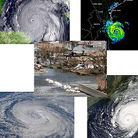
2005 Atlantic hurricane season
The 2005 Atlantic hurricane season was the most active Atlantic hurricane season in recorded history, repeatedly shattering numerous records. The impact of the season was widespread and ruinous with an estimated 3,913 deaths and record damage of about $159.2 billion...
officially began June 1, 2005 and officially ended on November 30, 2005. These dates conventionally delimit the period of each year when most tropical cyclone
Tropical cyclone
A tropical cyclone is a storm system characterized by a large low-pressure center and numerous thunderstorms that produce strong winds and heavy rain. Tropical cyclones strengthen when water evaporated from the ocean is released as the saturated air rises, resulting in condensation of water vapor...
s form in the Atlantic basin
Atlantic Basin
The Atlantic Basin is the Atlantic Ocean.Atlantic Basin may also refer to:* Atlantic Basin Iron Works, an ironworks that operated in Brooklyn, New York, in the early to mid-20th century...
, although effectively the season persisted into January 2006 due to continued storm activity.
The 2005 season was the most active season on record, shattering records on repeated occasions. A record 28 tropical and subtropical storms formed, of which a record fifteen became hurricanes. Of these, seven strengthened into major hurricanes, a record-tying five became Category 4 hurricanes
Saffir-Simpson Hurricane Scale
The Saffir–Simpson Hurricane Scale , or the Saffir–Simpson Hurricane Wind Scale , classifies hurricanes — Western Hemisphere tropical cyclones that exceed the intensities of tropical depressions and tropical storms — into five categories distinguished by the intensities of their sustained winds...
and a record four reached Category 5 strength, the highest categorization for North Atlantic tropical cyclones. Among these Category 5 storms was Hurricane Wilma
Hurricane Wilma
Hurricane Wilma was the most intense tropical cyclone ever recorded in the Atlantic basin. Wilma was the twenty-second storm , thirteenth hurricane, sixth major hurricane, and fourth Category 5 hurricane of the record-breaking 2005 season...
, the most intense hurricane ever recorded in the Atlantic.
The most notable storms of the season were the five Category 4 and Category 5 hurricanes: Dennis
Hurricane Dennis
Hurricane Dennis was an early-forming major hurricane in the Caribbean and Gulf of Mexico during the very active 2005 Atlantic hurricane season. Dennis was the fourth named storm, second hurricane, and first major hurricane of the season...
, Emily
Hurricane Emily (2005)
Hurricane Emily was a powerful, early season tropical cyclone that caused significant damage across the Caribbean Sea to Mexico. A Cape Verde-type hurricane, the storm formed on July 10, 2005, in the central Atlantic Ocean before passing through the Windward Islands on July 14...
, Katrina
Hurricane Katrina
Hurricane Katrina of the 2005 Atlantic hurricane season was a powerful Atlantic hurricane. It is the costliest natural disaster, as well as one of the five deadliest hurricanes, in the history of the United States. Among recorded Atlantic hurricanes, it was the sixth strongest overall...
, Rita
Hurricane Rita
Hurricane Rita was the fourth-most intense Atlantic hurricane ever recorded and the most intense tropical cyclone ever observed in the Gulf of Mexico. Rita caused $11.3 billion in damage on the U.S. Gulf Coast in September 2005...
, and Wilma
Hurricane Wilma
Hurricane Wilma was the most intense tropical cyclone ever recorded in the Atlantic basin. Wilma was the twenty-second storm , thirteenth hurricane, sixth major hurricane, and fourth Category 5 hurricane of the record-breaking 2005 season...
, along with the Category 1 Hurricane Stan
Hurricane Stan
Hurricane Stan was the eighteenth named tropical storm and eleventh hurricane of the 2005 Atlantic hurricane season. It was also the sixth of seven tropical cyclones to make landfall in Mexico. Stan was a relatively weak storm that only briefly reached hurricane status...
. These storms made a combined twelve landfalls as major hurricanes (Category 3 strength or higher) throughout Cuba
Cuba
The Republic of Cuba is an island nation in the Caribbean. The nation of Cuba consists of the main island of Cuba, the Isla de la Juventud, and several archipelagos. Havana is the largest city in Cuba and the country's capital. Santiago de Cuba is the second largest city...
, Mexico
Mexico
The United Mexican States , commonly known as Mexico , is a federal constitutional republic in North America. It is bordered on the north by the United States; on the south and west by the Pacific Ocean; on the southeast by Guatemala, Belize, and the Caribbean Sea; and on the east by the Gulf of...
, and the Gulf Coast of the United States
Gulf Coast of the United States
The Gulf Coast of the United States, sometimes referred to as the Gulf South, South Coast, or 3rd Coast, comprises the coasts of American states that are on the Gulf of Mexico, which includes Texas, Louisiana, Mississippi, Alabama, and Florida and are known as the Gulf States...
, causing over $100 billion (2005 USD) in damages and at least 2,048 deaths.
| Tropical cyclone A tropical cyclone is a storm system characterized by a large low-pressure center and numerous thunderstorms that produce strong winds and heavy rain. Tropical cyclones strengthen when water evaporated from the ocean is released as the saturated air rises, resulting in condensation of water vapor... |
|||||||||||||||||||||||||||||||||||||||||||||||||||||||||||||||||||||||||
EWLINE
|
table cellpadding="1" cellspacing="0" style="text-align: left; margin: auto; font-size: 90%; background:transparent;"> | ||||||||||||||||||||||||||||||||||||||||||||||||||||||||||||||||||||||||
|
|
|
|
|
|
|
|
|
|
| |||||||||||||||||||||||||||||||||||||||||||||||||||||||||||||||
Tropical Storm Arlene
Early in the season, a low-pressure area formed and persisted north of HondurasHonduras
Honduras is a republic in Central America. It was previously known as Spanish Honduras to differentiate it from British Honduras, which became the modern-day state of Belize...
. Despite moderate wind shear, the low managed to organize, and was designated Tropical Depression One on June 8. The storm strengthened further, and it was upgraded to Tropical Storm Arlene on the following day. From this point, Arlene headed north, intensifying steadily as it spread tropical storm-force winds and heavy rains to the Cayman Islands
Cayman Islands
The Cayman Islands is a British Overseas Territory and overseas territory of the European Union located in the western Caribbean Sea. The territory comprises the three islands of Grand Cayman, Cayman Brac, and Little Cayman, located south of Cuba and northwest of Jamaica...
and Cuba
Cuba
The Republic of Cuba is an island nation in the Caribbean. The nation of Cuba consists of the main island of Cuba, the Isla de la Juventud, and several archipelagos. Havana is the largest city in Cuba and the country's capital. Santiago de Cuba is the second largest city...
. Arlene made landfall in Cuba near Cabo Corrientes
Cabo Corrientes
Cabo Corrientes is a cape on the Pacific coast of the Mexican state of Jalisco. It marks the southernmost point of the Bahía de Banderas, upon which the port and resort city of Puerto Vallarta stands. The municipality in which the cape lies is also called Cabo Corrientes.Cabo Corrientes is a...
with 50 mph (80 km/h) winds. Wind shear weakened as the storm entered the Gulf of Mexico
Gulf of Mexico
The Gulf of Mexico is a partially landlocked ocean basin largely surrounded by the North American continent and the island of Cuba. It is bounded on the northeast, north and northwest by the Gulf Coast of the United States, on the southwest and south by Mexico, and on the southeast by Cuba. In...
on the morning of June 10, and the storm intensified to just under hurricane strength with 70 mph (110 km/h) winds.
Arlene made landfall just west of Pensacola, Florida
Pensacola, Florida
Pensacola is the westernmost city in the Florida Panhandle and the county seat of Escambia County, Florida, United States of America. As of the 2000 census, the city had a total population of 56,255 and as of 2009, the estimated population was 53,752...
with 60 mph (95 km/h) winds on June 11. After moving inland, Arlene persisted as a dissipating tropical depression for two days, passing into Indiana
Indiana
Indiana is a US state, admitted to the United States as the 19th on December 11, 1816. It is located in the Midwestern United States and Great Lakes Region. With 6,483,802 residents, the state is ranked 15th in population and 16th in population density. Indiana is ranked 38th in land area and is...
and Michigan
Michigan
Michigan is a U.S. state located in the Great Lakes Region of the United States of America. The name Michigan is the French form of the Ojibwa word mishigamaa, meaning "large water" or "large lake"....
before being absorbed by a frontal system over southeastern Canada on June 14.
The only death attributed to Arlene was a female student caught in rip current
Rip current
A rip current, commonly referred to by the misnomer rip tide, is a strong channel of water flowing seaward from near the shore, typically through the surf line. Typical flow is at 0.5 metres per second , and can be as fast as 2.5 metres per second...
in Miami Beach, Florida
Miami Beach, Florida
Miami Beach is a coastal resort city in Miami-Dade County, Florida, United States, incorporated on March 26, 1915. The municipality is located on a barrier island between the Atlantic Ocean and Biscayne Bay, the latter which separates the Beach from Miami city proper...
, far from the center of circulation. Damage from Arlene totaled to $11.8 million (2005 USD; $ USD).
- The National Hurricane Center (NHC)National Hurricane CenterThe National Hurricane Center , located at Florida International University in Miami, Florida, is the division of the National Weather Service responsible for tracking and predicting weather systems within the tropics between the Prime Meridian and the 140th meridian west poleward to the 30th...
's archive on Tropical Storm Arlene - The Hydrometeorological Prediction Center (HPC)Hydrometeorological Prediction CenterThe Hydrometeorological Prediction Center is one of nine service centers under the umbrella of the National Centers for Environmental Prediction , a part of the National Weather Service, which in turn is part of the National Oceanic and Atmospheric Administration of the U.S. government...
's archive on Tropical Storm Arlene
Tropical Storm Bret
After nearly two weeks of inactivity, an area of disturbed weather developed in the Bay of CampecheBay of Campeche
The Bay of Campeche is the southern bight of the Gulf of Mexico. It is surrounded on three sides by the Mexican states of Campeche, Tabasco and Veracruz. It was named by Francisco Hernández de Córdoba and Antonio de Alaminos during their expedition in 1517...
and quickly became better organized. It was designated Tropical Depression Two on the evening of June 28, and, two hours later, data from a Hurricane Hunter aircraft indicated that it had strengthened into a tropical storm, at which point the system was named Bret. This was the first time that two tropical storms had formed in June since the 1986 season
1986 Atlantic hurricane season
The 1986 Atlantic hurricane season officially began on June 1, 1986, and lasted until November 30, 1986. These dates conventionally delimit the period of each year when most tropical cyclones form in the Atlantic basin...
, and only the thirteenth time since 1851.
As the storm developed very close to shore, it only briefly traveled west-northwest before making landfall near Tuxpan
Tuxpan
Tuxpan is both a municipality and city located in the Mexican state of Veracruz. The population of the city was 78,523 and of the municipality was 134,394 inhabitants, according to the INEGI census of 2005, residing in a total area of 1,051.89 km²...
, Veracruz
Veracruz
Veracruz, formally Veracruz de Ignacio de la Llave officially Estado Libre y Soberano de Veracruz de Ignacio de la Llave , is one of the 31 states that, along with the Federal District, comprise the 32 federative entities of Mexico. It is divided in 212 municipalities and its capital city is...
, Mexico
Mexico
The United Mexican States , commonly known as Mexico , is a federal constitutional republic in North America. It is bordered on the north by the United States; on the south and west by the Pacific Ocean; on the southeast by Guatemala, Belize, and the Caribbean Sea; and on the east by the Gulf of...
early on June 29 as a weak tropical storm. It continued inland, producing heavy rain over the state of Veracruz until dissipating over the mountains of San Luis Potosí
San Luis Potosí
San Luis Potosí officially Estado Libre y Soberano de San Luis Potosí is one of the 31 states which, with the Federal District, comprise the 32 Federal Entities of Mexico. It is divided in 58 municipalities and its capital city is San Luis Potosí....
late on June 29. Hundreds of homes were damaged, and several towns, including Naranjos and Chinampa, about 60 miles (95 km) south of Tampico
Tampico
Tampico is a city and port in the state of Tamaulipas, in the country of Mexico. It is located in the southeastern part of the state, directly north across the border from Veracruz. Tampico is the third largest city in Tamaulipas, and counts with a population of 309,003. The Metropolitan area of...
, were severely flooded, but the only reported fatalities were the two occupants of a car that was swept away by floodwaters in Naranjos.
- The NHC's archive on Tropical Storm Bret
Hurricane Cindy
Tropical Depression Three formed on July 3 in the Caribbean Sea, but the next day, before being able to strengthen, it moved over the Yucatán PeninsulaYucatán Peninsula
The Yucatán Peninsula, in southeastern Mexico, separates the Caribbean Sea from the Gulf of Mexico, with the northern coastline on the Yucatán Channel...
. The system emerged into the Gulf of Mexico
Gulf of Mexico
The Gulf of Mexico is a partially landlocked ocean basin largely surrounded by the North American continent and the island of Cuba. It is bounded on the northeast, north and northwest by the Gulf Coast of the United States, on the southwest and south by Mexico, and on the southeast by Cuba. In...
on July 4 at which point a new center of circulation developed at the northern edge of the system and the system strengthened to a tropical storm, becoming Tropical Storm Cindy early July 4. The storm moved rapidly across the Gulf and made landfall near Grand Isle, Louisiana
Grand Isle, Louisiana
Grand Isle is a town in Jefferson Parish, Louisiana, located on a barrier island of the same name in the Gulf of Mexico. The island is at the mouth of Barataria Bay where it meets the gulf. As of the 2000 census, the town population was 1,541; during summers, the population sometimes increases to...
late July 5 as a minimal hurricane; though it was originally thought to have been only a tropical storm at landfall, it was upgraded to a hurricane in the post-storm analysis. As most storms do, it weakened while over land and became extratropical
Extratropical cyclone
Extratropical cyclones, sometimes called mid-latitude cyclones or wave cyclones, are a group of cyclones defined as synoptic scale low pressure weather systems that occur in the middle latitudes of the Earth having neither tropical nor polar characteristics, and are connected with fronts and...
over the Carolinas on July 7.
As a tropical depression well inland, Cindy spawned an F2
Fujita scale
The Fujita scale , or Fujita-Pearson scale, is a scale for rating tornado intensity, based primarily on the damage tornadoes inflict on human-built structures and vegetation...
tornado
Tornado
A tornado is a violent, dangerous, rotating column of air that is in contact with both the surface of the earth and a cumulonimbus cloud or, in rare cases, the base of a cumulus cloud. They are often referred to as a twister or a cyclone, although the word cyclone is used in meteorology in a wider...
which damaged landmarks in Hampton, Georgia
Hampton, Georgia
Hampton is a city in southwestern Henry County, Georgia, United States. As of the 2010 census, the city had a population of 6,987. Census Estimates for 2005 show a population of 4,743. Hampton mailing addresses also dip into eastern Clayton County and northern Spalding County.The Atlanta Motor...
, including the Atlanta Motor Speedway
Atlanta Motor Speedway
Atlanta Motor Speedway is a track just outside Hampton, Georgia, twenty miles south of Atlanta. It is a quad-oval track with a seating capacity of over 125,000. It opened in 1960 as a standard oval. In 1994, 46 condominiums were built over the northeastern side of the track...
, which suffered $40 million in damage alone. While tornadoes are often spawned by tropical systems, F2 tornadoes spawned this way are relatively rare. Large and sometimes record-breaking amounts of rain, more than 5 inches (127 mm) in places, fell over parts of Louisiana
Louisiana
Louisiana is a state located in the southern region of the United States of America. Its capital is Baton Rouge and largest city is New Orleans. Louisiana is the only state in the U.S. with political subdivisions termed parishes, which are local governments equivalent to counties...
, Mississippi
Mississippi
Mississippi is a U.S. state located in the Southern United States. Jackson is the state capital and largest city. The name of the state derives from the Mississippi River, which flows along its western boundary, whose name comes from the Ojibwe word misi-ziibi...
, Alabama
Alabama
Alabama is a state located in the southeastern region of the United States. It is bordered by Tennessee to the north, Georgia to the east, Florida and the Gulf of Mexico to the south, and Mississippi to the west. Alabama ranks 30th in total land area and ranks second in the size of its inland...
, and Maryland
Maryland
Maryland is a U.S. state located in the Mid Atlantic region of the United States, bordering Virginia, West Virginia, and the District of Columbia to its south and west; Pennsylvania to its north; and Delaware to its east...
. Three deaths were attributed to Cindy—two in Georgia
Georgia (U.S. state)
Georgia is a state located in the southeastern United States. It was established in 1732, the last of the original Thirteen Colonies. The state is named after King George II of Great Britain. Georgia was the fourth state to ratify the United States Constitution, on January 2, 1788...
and another in Alabama.
- The NHC's archive on Hurricane Cindy
- The HPC's archive on Hurricane Cindy
Hurricane Dennis
Tropical Depression Four formed in the southeastern Caribbean on the evening of July 4. Early the next day, it strengthened into Tropical Storm Dennis. The storm began moving rapidly to the west-northwest, and reached hurricane strength on the afternoon of July 6 while approaching the southern coast of HispaniolaHispaniola
Hispaniola is a major island in the Caribbean, containing the two sovereign states of the Dominican Republic and Haiti. The island is located between the islands of Cuba to the west and Puerto Rico to the east, within the hurricane belt...
. The next day it strengthened rapidly to become a Category 4 hurricane. Dennis moved between Jamaica
Jamaica
Jamaica is an island nation of the Greater Antilles, in length, up to in width and 10,990 square kilometres in area. It is situated in the Caribbean Sea, about south of Cuba, and west of Hispaniola, the island harbouring the nation-states Haiti and the Dominican Republic...
and Haiti
Haiti
Haiti , officially the Republic of Haiti , is a Caribbean country. It occupies the western, smaller portion of the island of Hispaniola, in the Greater Antillean archipelago, which it shares with the Dominican Republic. Ayiti was the indigenous Taíno or Amerindian name for the island...
on July 7. Dennis reached its peak as the strongest recorded Atlantic storm to form before August with a minimum central pressure of 930 mbar just south of Cuba
Cuba
The Republic of Cuba is an island nation in the Caribbean. The nation of Cuba consists of the main island of Cuba, the Isla de la Juventud, and several archipelagos. Havana is the largest city in Cuba and the country's capital. Santiago de Cuba is the second largest city...
- a record that would stand only for eight days until Emily
Hurricane Emily (2005)
Hurricane Emily was a powerful, early season tropical cyclone that caused significant damage across the Caribbean Sea to Mexico. A Cape Verde-type hurricane, the storm formed on July 10, 2005, in the central Atlantic Ocean before passing through the Windward Islands on July 14...
broke it. On July 8, Dennis passed over Cuba
Cuba
The Republic of Cuba is an island nation in the Caribbean. The nation of Cuba consists of the main island of Cuba, the Isla de la Juventud, and several archipelagos. Havana is the largest city in Cuba and the country's capital. Santiago de Cuba is the second largest city...
close to the capital, Havana
Havana
Havana is the capital city, province, major port, and leading commercial centre of Cuba. The city proper has a population of 2.1 million inhabitants, and it spans a total of — making it the largest city in the Caribbean region, and the most populous...
. A second episode of rapid intensification occurred on July 9 as it moved north toward the Gulf Coast of the United States
Gulf Coast of the United States
The Gulf Coast of the United States, sometimes referred to as the Gulf South, South Coast, or 3rd Coast, comprises the coasts of American states that are on the Gulf of Mexico, which includes Texas, Louisiana, Mississippi, Alabama, and Florida and are known as the Gulf States...
. Dennis made landfall as a Category 3 storm just southeast of Pensacola, Florida
Pensacola, Florida
Pensacola is the westernmost city in the Florida Panhandle and the county seat of Escambia County, Florida, United States of America. As of the 2000 census, the city had a total population of 56,255 and as of 2009, the estimated population was 53,752...
.
Dennis claimed at least 88 lives: 56 in Haiti
Haiti
Haiti , officially the Republic of Haiti , is a Caribbean country. It occupies the western, smaller portion of the island of Hispaniola, in the Greater Antillean archipelago, which it shares with the Dominican Republic. Ayiti was the indigenous Taíno or Amerindian name for the island...
, 16 in Cuba, 15 in the U.S. and 1 in Jamaica. Total damages are estimated at $4–6 billion USD, including $2.23 billion in the United States and the rest in the Caribbean. Dennis was most damaging to Cuba
Cuba
The Republic of Cuba is an island nation in the Caribbean. The nation of Cuba consists of the main island of Cuba, the Isla de la Juventud, and several archipelagos. Havana is the largest city in Cuba and the country's capital. Santiago de Cuba is the second largest city...
, where the storm wiped out a significant portion of the citrus
Citrus
Citrus is a common term and genus of flowering plants in the rue family, Rutaceae. Citrus is believed to have originated in the part of Southeast Asia bordered by Northeastern India, Myanmar and the Yunnan province of China...
crop. As the storm struck near the end of Cuba's dry season, farmers were not yet prepared for the heavy rainfall brought by the storm. In the United States, Dennis drew comparison with Hurricane Ivan
Hurricane Ivan
Hurricane Ivan was a large, long-lived, Cape Verde-type hurricane that caused widespread damage in the Caribbean and United States. The cyclone was the ninth named storm, the sixth hurricane and the fourth major hurricane of the active 2004 Atlantic hurricane season...
of the previous year, but it was both smaller and weaker than Ivan at landfall and caused significantly fewer damages, partly because the region had not yet fully rebuilt.
- The NHC's archive on Hurricane Dennis
- The HPC's archive on Hurricane Dennis
Hurricane Emily
Emily formed from Tropical Depression Five east of the Lesser AntillesLesser Antilles
The Lesser Antilles are a long, partly volcanic island arc in the Western Hemisphere. Most of its islands form the eastern boundary of the Caribbean Sea with the Atlantic Ocean, with the remainder located in the southern Caribbean just north of South America...
on July 11. It moved westward and hit Grenada
Grenada
Grenada is an island country and Commonwealth Realm consisting of the island of Grenada and six smaller islands at the southern end of the Grenadines in the southeastern Caribbean Sea...
on July 14 as a Category 1 storm. It entered the Caribbean Sea
Caribbean Sea
The Caribbean Sea is a sea of the Atlantic Ocean located in the tropics of the Western hemisphere. It is bounded by Mexico and Central America to the west and southwest, to the north by the Greater Antilles, and to the east by the Lesser Antilles....
and began intensifying rapidly. It reached Category 4 intensity on July 15. Emily broke Hurricane Dennis
Hurricane Dennis
Hurricane Dennis was an early-forming major hurricane in the Caribbean and Gulf of Mexico during the very active 2005 Atlantic hurricane season. Dennis was the fourth named storm, second hurricane, and first major hurricane of the season...
's eight-day-old record for the most intense storm to form prior to August when it reached a minimum pressure of 929 mbar, along with 160 mph (260 km/h) winds on July 16. It was originally believed that Emily peaked at Category 4. However, some readings indicated that Emily briefly reached Category 5 strength around this time, and Emily was upgraded to Category 5 status in the post-storm analysis. The storm weakened slightly, however, and after passing south of Jamaica
Jamaica
Jamaica is an island nation of the Greater Antilles, in length, up to in width and 10,990 square kilometres in area. It is situated in the Caribbean Sea, about south of Cuba, and west of Hispaniola, the island harbouring the nation-states Haiti and the Dominican Republic...
and the Cayman Islands
Cayman Islands
The Cayman Islands is a British Overseas Territory and overseas territory of the European Union located in the western Caribbean Sea. The territory comprises the three islands of Grand Cayman, Cayman Brac, and Little Cayman, located south of Cuba and northwest of Jamaica...
, Emily made landfall on the Yucatán Peninsula
Yucatán Peninsula
The Yucatán Peninsula, in southeastern Mexico, separates the Caribbean Sea from the Gulf of Mexico, with the northern coastline on the Yucatán Channel...
near Tulum on the morning of July 18 as a Category 4 hurricane. Emily emerged over the Bay of Campeche
Bay of Campeche
The Bay of Campeche is the southern bight of the Gulf of Mexico. It is surrounded on three sides by the Mexican states of Campeche, Tabasco and Veracruz. It was named by Francisco Hernández de Córdoba and Antonio de Alaminos during their expedition in 1517...
and made its second landfall in rural northeast Mexico
Mexico
The United Mexican States , commonly known as Mexico , is a federal constitutional republic in North America. It is bordered on the north by the United States; on the south and west by the Pacific Ocean; on the southeast by Guatemala, Belize, and the Caribbean Sea; and on the east by the Gulf of...
near Boca Madre, Tamaulipas
Tamaulipas
Tamaulipas officially Estado Libre y Soberano de Tamaulipas is one of the 31 states which, with the Federal District, comprise the 32 Federal Entities of Mexico. It is divided in 43 municipalities and its capital city is Ciudad Victoria. The capital city was named after Guadalupe Victoria, the...
as a Category 3 storm.
Emily is blamed for at least fourteen deaths; one in Grenada, four in Jamaica, seven in the Caribbean and two in Mexico. The storms also caused an estimated $550 million (2005 USD) in damages, almost entirely in Grenada
Grenada
Grenada is an island country and Commonwealth Realm consisting of the island of Grenada and six smaller islands at the southern end of the Grenadines in the southeastern Caribbean Sea...
and the Mexican state of Quintana Roo
Quintana Roo
Quintana Roo officially Estado Libre y Soberano de Quintana Roo is one of the 31 states which, with the Federal District, comprise the 32 Federal Entities of Mexico. It is divided in 10 municipalities and its capital city is Chetumal....
. Some minor flooding occurred in northeastern Mexico and extreme southern Texas
Texas
Texas is the second largest U.S. state by both area and population, and the largest state by area in the contiguous United States.The name, based on the Caddo word "Tejas" meaning "friends" or "allies", was applied by the Spanish to the Caddo themselves and to the region of their settlement in...
as a result of Emily's final landfall, but damages were light.
- The NHC's archive on Hurricane Emily
Tropical Storm Franklin
A tropical wave off the Bahamas organized into Tropical Depression Six on the afternoon of July 21. The depression became the sixth named storm of the season only two hours later, the first time the sixth storm of the season had ever formed that early in the season. The storm headed northward from the Bahamas, then northeast over the Atlantic, becoming disorganized by July 24 under the effects of shear and drier air. It moved erratically, inching closer to BermudaBermuda
Bermuda is a British overseas territory in the North Atlantic Ocean. Located off the east coast of the United States, its nearest landmass is Cape Hatteras, North Carolina, about to the west-northwest. It is about south of Halifax, Nova Scotia, Canada, and northeast of Miami, Florida...
while barely remaining a tropical storm. Bermuda received some strong wind gusts, but was otherwise unaffected. Tropical Storm Franklin then accelerated north and northeast, roughly paralleling the East Coast of the United States
East Coast of the United States
The East Coast of the United States, also known as the Eastern Seaboard, refers to the easternmost coastal states in the United States, which touch the Atlantic Ocean and stretch up to Canada. The term includes the U.S...
, and intensified to near hurricane strength. Eventually, Franklin became extratropical along the coast of Nova Scotia
Nova Scotia
Nova Scotia is one of Canada's three Maritime provinces and is the most populous province in Atlantic Canada. The name of the province is Latin for "New Scotland," but "Nova Scotia" is the recognized, English-language name of the province. The provincial capital is Halifax. Nova Scotia is the...
and Newfoundland.
- The NHC's archive on Tropical Storm Franklin
Tropical Storm Gert
A tropical wave, which had earlier crossed HondurasHonduras
Honduras is a republic in Central America. It was previously known as Spanish Honduras to differentiate it from British Honduras, which became the modern-day state of Belize...
and the Yucatán
Yucatán
Yucatán officially Estado Libre y Soberano de Yucatán is one of the 31 states which, with the Federal District, comprise the 32 Federal Entities of Mexico. It is divided in 106 municipalities and its capital city is Mérida....
peninsula, organized into Tropical Depression Seven on the afternoon of July 23 in the Bay of Campeche
Bay of Campeche
The Bay of Campeche is the southern bight of the Gulf of Mexico. It is surrounded on three sides by the Mexican states of Campeche, Tabasco and Veracruz. It was named by Francisco Hernández de Córdoba and Antonio de Alaminos during their expedition in 1517...
. It was upgraded to Tropical Storm Gert early the next day, the earliest formation of a seventh named storm on record. It strengthened little before making landfall on the coast of Mexico
Mexico
The United Mexican States , commonly known as Mexico , is a federal constitutional republic in North America. It is bordered on the north by the United States; on the south and west by the Pacific Ocean; on the southeast by Guatemala, Belize, and the Caribbean Sea; and on the east by the Gulf of...
south of Tampico
Tampico
Tampico is a city and port in the state of Tamaulipas, in the country of Mexico. It is located in the southeastern part of the state, directly north across the border from Veracruz. Tampico is the third largest city in Tamaulipas, and counts with a population of 309,003. The Metropolitan area of...
late on July 24 with maximum sustained winds of 50 mph (70 km/h) and a minimum central pressure of 1001 mbar (29.6 inHg). It moved inland over central Mexico
Mexico
The United Mexican States , commonly known as Mexico , is a federal constitutional republic in North America. It is bordered on the north by the United States; on the south and west by the Pacific Ocean; on the southeast by Guatemala, Belize, and the Caribbean Sea; and on the east by the Gulf of...
before dissipating on July 25.
Gert struck in roughly the same area as Hurricane Emily
Hurricane Emily (2005)
Hurricane Emily was a powerful, early season tropical cyclone that caused significant damage across the Caribbean Sea to Mexico. A Cape Verde-type hurricane, the storm formed on July 10, 2005, in the central Atlantic Ocean before passing through the Windward Islands on July 14...
just four days earlier, causing fear of flooding and landslides due to saturated lands. As a precaution some 1,000 people were evacuated from low-lying residences and businesses near the towns of Naranjos and Tamiahua.
- The NHC's archive on Tropical Storm Gert
Tropical Storm Harvey
A tropical wave organized into the eighth depression of the season due southwest of BermudaBermuda
Bermuda is a British overseas territory in the North Atlantic Ocean. Located off the east coast of the United States, its nearest landmass is Cape Hatteras, North Carolina, about to the west-northwest. It is about south of Halifax, Nova Scotia, Canada, and northeast of Miami, Florida...
on August 2. It became a tropical storm the next day.
Harvey was not initially a particularly well-organized storm, and had some subtropical characteristics, but it soon became more tropical in nature. It passed just south of Bermuda early on August 4 while at its peak intensity, with maximum sustained winds of 65 mph (105 km/h) and a minimum central pressure of 994 mbar. Though Bermuda was soaked by Harvey, the island sustained no damage.
Harvey then headed east and later northeast over the open Atlantic. The storm became extratropical on the afternoon of August 8.
- The NHC's archive on Tropical Storm Harvey
Hurricane Irene
Tropical Depression Nine formed from a tropical wave west of Cape VerdeCape Verde
The Republic of Cape Verde is an island country, spanning an archipelago of 10 islands located in the central Atlantic Ocean, 570 kilometres off the coast of Western Africa...
on the afternoon of August 4, the second Cape Verde-type storm
Cape Verde-type hurricane
A Cape Verde-type hurricane is an Atlantic hurricane that develops near the Cape Verde islands, off the west coast of Africa. The average hurricane season has about two Cape Verde-type hurricanes, which are usually the largest and most intense storms of the season because they often have plenty of...
of the season. The system encountered dry air and wind shear as it turned to the northwest and it broke down. Despite poor organization and shearing winds, it became Tropical Storm Irene on August 7. Further shear and dry air disrupted the cyclone's structure, and Irene was downgraded to a tropical depression on August 8.
Irene cycled between apparent reintensification and significant weakening, becoming so disorganized in the early morning of August 10 that forecasters were considering declaring the storm dissipated. However, the depression continued to move westward into more favorable conditions and again attained tropical storm status, rapidly strengthening to a Category 1 hurricane on August 14. Later, it strengthened even further in low shear conditions under an upper level anticyclone
Anticyclone
An anticyclone is a weather phenomenon defined by the United States' National Weather Service's glossary as "[a] large-scale circulation of winds around a central region of high atmospheric pressure, clockwise in the Northern Hemisphere, counterclockwise in the Southern Hemisphere"...
. On August 16 it briefly strengthened to a Category 2 hurricane, but began to weaken in cooler waters shortly thereafter. It became extratropical southeast of Cape Race, Newfoundland on August 18, having never posed a threat to land.
- The NHC's archive on Hurricane Irene
Tropical Depression Ten
Tropical Depression Ten formed 1100 statute miles (1770 km) east of the Lesser AntillesLesser Antilles
The Lesser Antilles are a long, partly volcanic island arc in the Western Hemisphere. Most of its islands form the eastern boundary of the Caribbean Sea with the Atlantic Ocean, with the remainder located in the southern Caribbean just north of South America...
on August 13. Conditions were not favorable for development, as strong vertical shear literally ripped the system apart, and advisories were discontinued the next day when it showed no organized deep convection. The remnants of Tropical Depression Ten continued drifting northwestward before degenerating into a tropical wave north of the Leeward Islands
Leeward Islands
The Leeward Islands are a group of islands in the West Indies. They are the northern islands of the Lesser Antilles chain. As a group they start east of Puerto Rico and reach southward to Dominica. They are situated where the northeastern Caribbean Sea meets the western Atlantic Ocean...
. The mid-level remnant circulation eventually merged with another system in the "complex genesis" of what would become Tropical Depression Twelve and, eventually, Hurricane Katrina
Hurricane Katrina
Hurricane Katrina of the 2005 Atlantic hurricane season was a powerful Atlantic hurricane. It is the costliest natural disaster, as well as one of the five deadliest hurricanes, in the history of the United States. Among recorded Atlantic hurricanes, it was the sixth strongest overall...
.
- The NHC's archive on Tropical Depression Ten
Tropical Storm Jose
Tropical Depression Eleven formed in the Bay of CampecheBay of Campeche
The Bay of Campeche is the southern bight of the Gulf of Mexico. It is surrounded on three sides by the Mexican states of Campeche, Tabasco and Veracruz. It was named by Francisco Hernández de Córdoba and Antonio de Alaminos during their expedition in 1517...
on August 22. Later in the day it strengthened into Tropical Storm Jose over the warm waters of the Gulf of Mexico and achieved a maximum strength of 60 mph (95 km/h) before it made landfall in the state of Veracruz
Veracruz
Veracruz, formally Veracruz de Ignacio de la Llave officially Estado Libre y Soberano de Veracruz de Ignacio de la Llave , is one of the 31 states that, along with the Federal District, comprise the 32 federative entities of Mexico. It is divided in 212 municipalities and its capital city is...
, Mexico
Mexico
The United Mexican States , commonly known as Mexico , is a federal constitutional republic in North America. It is bordered on the north by the United States; on the south and west by the Pacific Ocean; on the southeast by Guatemala, Belize, and the Caribbean Sea; and on the east by the Gulf of...
on August 23. It then rapidly weakened and soon dissipated as it moved inland over Mexico. While drenching Mexico's Gulf coast, Jose forced some 25,000 residents from their homes in Veracruz state. Eight deaths (six direct) were attributed to Jose's heavy rains in the Mexican state of Oaxaca
Oaxaca
Oaxaca , , officially Estado Libre y Soberano de Oaxaca is one of the 31 states which, along with the Federal District, comprise the 32 federative entities of Mexico. It is divided into 571 municipalities; of which 418 are governed by the system of customs and traditions...
. Two more were reported missing. Damage in Mexico totaled to $45 million.
Later analysis showed that Jose became more organized two hours before making landfall and was forming an eye, but its winds remained under hurricane strength. The final report suggested that the winds made it up to 60 mph (95 km/h) and made landfall as such, but was still rapidly intensifying before running out of water.
- The NHC's archive on Tropical Storm Jose
- The NHC's Tropical Cyclone Report for Jose
Hurricane Katrina
An area of disturbed weather over the Bahamas developed into a tropical depression on August 23, becoming a tropical storm on August 24 and a hurricane on August 25. It made landfall on August 25 in southern FloridaFlorida
Florida is a state in the southeastern United States, located on the nation's Atlantic and Gulf coasts. It is bordered to the west by the Gulf of Mexico, to the north by Alabama and Georgia and to the east by the Atlantic Ocean. With a population of 18,801,310 as measured by the 2010 census, it...
, emerging a few hours later into the Gulf of Mexico
Gulf of Mexico
The Gulf of Mexico is a partially landlocked ocean basin largely surrounded by the North American continent and the island of Cuba. It is bounded on the northeast, north and northwest by the Gulf Coast of the United States, on the southwest and south by Mexico, and on the southeast by Cuba. In...
. Katrina rapidly intensified to Category 5 status on the morning of August 28, becoming the fourth most intense recorded hurricane in the Atlantic basin
Atlantic Basin
The Atlantic Basin is the Atlantic Ocean.Atlantic Basin may also refer to:* Atlantic Basin Iron Works, an ironworks that operated in Brooklyn, New York, in the early to mid-20th century...
. The hurricane weakened to a Category 4 as it turned northward, and weakened to a Category 3 hurricane with 125 mph (200 km/h) winds as it made landfall in southeastern Louisiana
Louisiana
Louisiana is a state located in the southern region of the United States of America. Its capital is Baton Rouge and largest city is New Orleans. Louisiana is the only state in the U.S. with political subdivisions termed parishes, which are local governments equivalent to counties...
(as confirmed by the post-storm report; initially it was estimated as a Category 4 landfall). Hours later, it crossed the Breton Sound
Breton Sound
Breton Sound is a sound of the Gulf of Mexico and a part of the coastline of the U.S. state of Louisiana. It lies off the southeast coast of the state and is partially enclosed by the Breton Islands....
and held its strength, making its third and final landfall with 120 mph (190 km/h) winds near Pearlington, Mississippi
Pearlington, Mississippi
Pearlington is a census-designated place in Hancock County, Mississippi, United States, on U.S. Route 90, along the Pearl River, at the Louisiana stateline. It is part of the Gulfport–Biloxi, Mississippi Metropolitan Statistical Area. The population was 1,684 at the 2000 census. On August...
.
The Mississippi and Alabama coastlines suffered catastrophic damage from the storm's 30-foot (nine m) storm surge. New Orleans
New Orleans, Louisiana
New Orleans is a major United States port and the largest city and metropolitan area in the state of Louisiana. The New Orleans metropolitan area has a population of 1,235,650 as of 2009, the 46th largest in the USA. The New Orleans – Metairie – Bogalusa combined statistical area has a population...
escaped the worst damage from the storm, but levee
Levee
A levee, levée, dike , embankment, floodbank or stopbank is an elongated naturally occurring ridge or artificially constructed fill or wall, which regulates water levels...
s along the Gulf Intracoastal Waterway
Gulf Intracoastal Waterway
The Gulf Intracoastal Waterway is the portion of the Intracoastal Waterway located along the Gulf Coast of the United States. It is a navigable inland waterway running approximately 1700 kilometers from Carrabelle, Florida, to Brownsville, Texas.The waterway provides a channel with a controlling...
and 17th Street
17th Street Canal
The 17th Street Canal is a drainage canal in Greater New Orleans, Louisiana, that flows into Lake Pontchartrain. The canal forms a significant portion of the boundary between the city of New Orleans and Metairie, Louisiana...
and London Avenue Canal
London Avenue Canal
The London Avenue Canal is a drainage canal in New Orleans, Louisiana, used for pumping rain water into Lake Pontchartrain. The Canal runs through the 7th Ward of New Orleans from the Gentilly area to the Lakefront....
s ultimately were breached by storm surge
Storm surge
A storm surge is an offshore rise of water associated with a low pressure weather system, typically tropical cyclones and strong extratropical cyclones. Storm surges are caused primarily by high winds pushing on the ocean's surface. The wind causes the water to pile up higher than the ordinary sea...
, flooding about 80% of the city. 1,836 people have been confirmed dead across seven US states. Katrina is the costliest and one of the deadliest natural disasters in U.S. history, with damage totals around $81.2 billion (USD; $ USD). The damage and fatality estimates remain incomplete.
- The NHC's archive on Hurricane Katrina
- The HPC's archive on Hurricane Katrina
Tropical Storm Lee
A tropical waveTropical wave
Tropical waves, easterly waves, or tropical easterly waves, also known as African easterly waves in the Atlantic region, are a type of atmospheric trough, an elongated area of relatively low air pressure, oriented north to south, which move from east to west across the tropics causing areas of...
moved off the coast of Africa on August 24. It developed into an area of low pressure as it crossed the Atlantic, and organized into Tropical Depression Thirteen on August 28 while 960 mi (1550 km) east of the Lesser Antilles
Lesser Antilles
The Lesser Antilles are a long, partly volcanic island arc in the Western Hemisphere. Most of its islands form the eastern boundary of the Caribbean Sea with the Atlantic Ocean, with the remainder located in the southern Caribbean just north of South America...
.
Because of northeasterly shear
Wind shear
Wind shear, sometimes referred to as windshear or wind gradient, is a difference in wind speed and direction over a relatively short distance in the atmosphere...
, the center of the circulation was removed from the convection
Convection
Convection is the movement of molecules within fluids and rheids. It cannot take place in solids, since neither bulk current flows nor significant diffusion can take place in solids....
, and the depression degenerated into a remnant low late on August 29. Many of the models had indicated that this was likely, but the National Hurricane Center
National Hurricane Center
The National Hurricane Center , located at Florida International University in Miami, Florida, is the division of the National Weather Service responsible for tracking and predicting weather systems within the tropics between the Prime Meridian and the 140th meridian west poleward to the 30th...
(NHC) instead chose to forecast slight strengthening.
The remnant low moved to the north and later northeast, due to a non-tropical system. The convection increased and the depression regenerated on August 31. That afternoon, the depression strengthened further into Tropical Storm Lee
Lee (English name)
Lee is a common surname in English-speaking countries. There are several distinct origins of the Lee surname. The most common surname of English origin is derived from Middle English lea, meaning "meadow, forest clearing" , and is therefore a name describing the bearer's place of residence...
, reaching its peak intensity with winds of 40 mph (65 km/h), in between Bermuda
Bermuda
Bermuda is a British overseas territory in the North Atlantic Ocean. Located off the east coast of the United States, its nearest landmass is Cape Hatteras, North Carolina, about to the west-northwest. It is about south of Halifax, Nova Scotia, Canada, and northeast of Miami, Florida...
and the Azores
Azores
The Archipelago of the Azores is composed of nine volcanic islands situated in the middle of the North Atlantic Ocean, and is located about west from Lisbon and about east from the east coast of North America. The islands, and their economic exclusion zone, form the Autonomous Region of the...
. There was uncertainty in its intensity, and it quickly weakened to tropical depression status again. Lee moved around the non-tropical low to its west, causing forecasting difficulties with regards to how tropical it remained. Later on September 1, shear again removed the convection of the depression, and Lee became a remnant low that survived until September 4 when it was absorbed by a cold front
Cold front
A cold front is defined as the leading edge of a cooler mass of air, replacing a warmer mass of air.-Development of cold front:The cooler and denser air wedges under the less-dense warmer air, lifting it...
. It never affected land, and there were no reports of damage or fatalities.
- The NHC's archive on Tropical Storm Lee
Hurricane Maria
Tropical Depression Fourteen formed from a tropical waveTropical wave
Tropical waves, easterly waves, or tropical easterly waves, also known as African easterly waves in the Atlantic region, are a type of atmospheric trough, an elongated area of relatively low air pressure, oriented north to south, which move from east to west across the tropics causing areas of...
1100 statute miles (1,770 km) east of the Leeward Islands
Leeward Islands
The Leeward Islands are a group of islands in the West Indies. They are the northern islands of the Lesser Antilles chain. As a group they start east of Puerto Rico and reach southward to Dominica. They are situated where the northeastern Caribbean Sea meets the western Atlantic Ocean...
on September 1, and strengthened to Tropical Storm Maria the next day. Early on September 4, Maria became the fifth hurricane of the season. On September 5, it briefly strengthened to Category 3 intensity, making it the fourth major hurricane of the season. It gradually weakened and dropped to tropical storm strength on September 8.
Maria became extratropical mid-way between Cape Race
Cape Race
Cape Race is a point of land located at the southeastern tip of the Avalon Peninsula on the island of Newfoundland, Canada. Its name is thought to come from the original Portuguese name for this cape, "Raso", or "bare"...
and the Azores
Azores
The Archipelago of the Azores is composed of nine volcanic islands situated in the middle of the North Atlantic Ocean, and is located about west from Lisbon and about east from the east coast of North America. The islands, and their economic exclusion zone, form the Autonomous Region of the...
on September 10. It never threatened land as a hurricane, but Maria became a strong extratropical storm, and actually strengthened to hurricane strength once again while moving towards Iceland
Iceland
Iceland , described as the Republic of Iceland, is a Nordic and European island country in the North Atlantic Ocean, on the Mid-Atlantic Ridge. Iceland also refers to the main island of the country, which contains almost all the population and almost all the land area. The country has a population...
.
The remnants of Maria triggered a landslide in Norway
Norway
Norway , officially the Kingdom of Norway, is a Nordic unitary constitutional monarchy whose territory comprises the western portion of the Scandinavian Peninsula, Jan Mayen, and the Arctic archipelago of Svalbard and Bouvet Island. Norway has a total area of and a population of about 4.9 million...
that killed three people.
- The NHC's archive on Hurricane Maria
Hurricane Nate
A well-defined low pressure system located about 350 statute miles (560 km) south-southwest of BermudaBermuda
Bermuda is a British overseas territory in the North Atlantic Ocean. Located off the east coast of the United States, its nearest landmass is Cape Hatteras, North Carolina, about to the west-northwest. It is about south of Halifax, Nova Scotia, Canada, and northeast of Miami, Florida...
organized into a tropical depression on September 5. It strengthened into Tropical Storm Nate that evening and continued to strengthen with little change in position, becoming the sixth hurricane of the season on September 7.
Hurricane Nate passed 125 statute miles (200 km) south of Bermuda
Bermuda
Bermuda is a British overseas territory in the North Atlantic Ocean. Located off the east coast of the United States, its nearest landmass is Cape Hatteras, North Carolina, about to the west-northwest. It is about south of Halifax, Nova Scotia, Canada, and northeast of Miami, Florida...
on September 8 and reached peak intensity of 90 mph (160 km/h). Nate then began to weaken. After turning north, it became extratropical over the central Atlantic Ocean
Atlantic Ocean
The Atlantic Ocean is the second-largest of the world's oceanic divisions. With a total area of about , it covers approximately 20% of the Earth's surface and about 26% of its water surface area...
on September 10.
Canadian Navy ships headed to the U.S. Gulf Coast
Gulf Coast of the United States
The Gulf Coast of the United States, sometimes referred to as the Gulf South, South Coast, or 3rd Coast, comprises the coasts of American states that are on the Gulf of Mexico, which includes Texas, Louisiana, Mississippi, Alabama, and Florida and are known as the Gulf States...
to help in the aftermath of Hurricane Katrina
Hurricane Katrina
Hurricane Katrina of the 2005 Atlantic hurricane season was a powerful Atlantic hurricane. It is the costliest natural disaster, as well as one of the five deadliest hurricanes, in the history of the United States. Among recorded Atlantic hurricanes, it was the sixth strongest overall...
were slowed down trying to avoid Nate and Hurricane Ophelia (see below).
- The NHC's archive on Hurricane Nate
Hurricane Ophelia
Tropical Depression Sixteen formed over the northern Bahamas on September 6. Early on September 7, it organized into Tropical Storm Ophelia, becoming a hurricane the next day. It churned nearly stationary for two days off the coast of FloridaFlorida
Florida is a state in the southeastern United States, located on the nation's Atlantic and Gulf coasts. It is bordered to the west by the Gulf of Mexico, to the north by Alabama and Georgia and to the east by the Atlantic Ocean. With a population of 18,801,310 as measured by the 2010 census, it...
where significant coastal erosion
Coastal erosion
Coastal erosion is the wearing away of land and the removal of beach or dune sediments by wave action, tidal currents, wave currents, or drainage...
resulted from the churning waves. On September 12, the storm began moving slowly toward North Carolina
North Carolina
North Carolina is a state located in the southeastern United States. The state borders South Carolina and Georgia to the south, Tennessee to the west and Virginia to the north. North Carolina contains 100 counties. Its capital is Raleigh, and its largest city is Charlotte...
, at times nearly stalling and alternating between tropical storm and hurricane intensity. The hurricane did not make landfall, although the western eyewall reached the coastal areas of North Carolina
North Carolina
North Carolina is a state located in the southeastern United States. The state borders South Carolina and Georgia to the south, Tennessee to the west and Virginia to the north. North Carolina contains 100 counties. Its capital is Raleigh, and its largest city is Charlotte...
, causing extensive damage in the Outer Banks
Outer Banks
The Outer Banks is a 200-mile long string of narrow barrier islands off the coast of North Carolina, beginning in the southeastern corner of Virginia Beach on the east coast of the United States....
and around Cape Fear. Ophelia moved north and became extratropical late on September 17 near Nova Scotia
Nova Scotia
Nova Scotia is one of Canada's three Maritime provinces and is the most populous province in Atlantic Canada. The name of the province is Latin for "New Scotland," but "Nova Scotia" is the recognized, English-language name of the province. The provincial capital is Halifax. Nova Scotia is the...
, but it continued northeastward, producing strong winds and heavy rain over Atlantic Canada
Atlantic Canada
Atlantic Canada is the region of Canada comprising the four provinces located on the Atlantic coast, excluding Quebec: the three Maritime provinces – New Brunswick, Prince Edward Island, and Nova Scotia – and Newfoundland and Labrador...
.
Only three fatalities were reported, one direct death in Florida
Florida
Florida is a state in the southeastern United States, located on the nation's Atlantic and Gulf coasts. It is bordered to the west by the Gulf of Mexico, to the north by Alabama and Georgia and to the east by the Atlantic Ocean. With a population of 18,801,310 as measured by the 2010 census, it...
from high surf, one indirect death in a traffic accident in North Carolina
North Carolina
North Carolina is a state located in the southeastern United States. The state borders South Carolina and Georgia to the south, Tennessee to the west and Virginia to the north. North Carolina contains 100 counties. Its capital is Raleigh, and its largest city is Charlotte...
and a second indirect death due to a fall in Nova Scotia
Nova Scotia
Nova Scotia is one of Canada's three Maritime provinces and is the most populous province in Atlantic Canada. The name of the province is Latin for "New Scotland," but "Nova Scotia" is the recognized, English-language name of the province. The provincial capital is Halifax. Nova Scotia is the...
. Damage is estimated at around $70 million, mostly in North Carolina
North Carolina
North Carolina is a state located in the southeastern United States. The state borders South Carolina and Georgia to the south, Tennessee to the west and Virginia to the north. North Carolina contains 100 counties. Its capital is Raleigh, and its largest city is Charlotte...
but also in the Bahamas and Nova Scotia
Nova Scotia
Nova Scotia is one of Canada's three Maritime provinces and is the most populous province in Atlantic Canada. The name of the province is Latin for "New Scotland," but "Nova Scotia" is the recognized, English-language name of the province. The provincial capital is Halifax. Nova Scotia is the...
and on the Florida
Florida
Florida is a state in the southeastern United States, located on the nation's Atlantic and Gulf coasts. It is bordered to the west by the Gulf of Mexico, to the north by Alabama and Georgia and to the east by the Atlantic Ocean. With a population of 18,801,310 as measured by the 2010 census, it...
coast. While the storm was initially estimated to have caused as much as $1 billion in damages, that number was determined to be a significant overestimate.
- The NHC's archive on Hurricane Ophelia
Hurricane Philippe
A vigorous tropical wave organized into Tropical Depression Seventeen on September 17 a few hundred miles east of the Leeward IslandsLeeward Islands
The Leeward Islands are a group of islands in the West Indies. They are the northern islands of the Lesser Antilles chain. As a group they start east of Puerto Rico and reach southward to Dominica. They are situated where the northeastern Caribbean Sea meets the western Atlantic Ocean...
. It was upgraded to a tropical storm late that evening. This marked only the third time that the 'P
P
P is the sixteenth letter of the basic modern Latin alphabet.-Usage:In English and most other European languages, P is a voiceless bilabial plosive. Both initial and final Ps can be combined with many other discrete consonants in English words...
' name had been used to name an Atlantic storm since alphabetical naming began in 1950. The other times were for Pablo in 1995, Peter in 2003, Paloma in 2008, Paula
Hurricane Paula (2010)
Hurricane Paula was a small but strong hurricane that impacted several areas surrounding the western Caribbean Sea. The sixteenth named storm of the 2010 Atlantic hurricane season, Paula developed from an area of low pressure over the southwestern Caribbean in early October 2010...
in 2010, and Philippe in 2011.
On September 18, Philippe was upgraded to a hurricane, becoming the eighth Atlantic hurricane of the season. It was downgraded to a tropical storm on the afternoon of September 20 and dissipated 3 days later south of Bermuda
Bermuda
Bermuda is a British overseas territory in the North Atlantic Ocean. Located off the east coast of the United States, its nearest landmass is Cape Hatteras, North Carolina, about to the west-northwest. It is about south of Halifax, Nova Scotia, Canada, and northeast of Miami, Florida...
.
- The NHC's archive on Hurricane Philippe
Hurricane Rita
The season's eighteenth tropical depression formed over the Turks and Caicos IslandsTurks and Caicos Islands
The Turks and Caicos Islands are a British Overseas Territory and overseas territory of the European Union consisting of two groups of tropical islands in the Caribbean, the larger Caicos Islands and the smaller Turks Islands, known for tourism and as an offshore financial centre.The Turks and...
on September 18. Later that day, it became the seventeenth tropical storm of the season. Rita slowly intensified to become a hurricane on September 20. It was at Category 1 and later Category 2 intensity as it moved south of the Florida Keys
Florida Keys
The Florida Keys are a coral archipelago in southeast United States. They begin at the southeastern tip of the Florida peninsula, about south of Miami, and extend in a gentle arc south-southwest and then westward to Key West, the westernmost of the inhabited islands, and on to the uninhabited Dry...
. Rapid intensification
Rapid deepening
Rapid deepening, also known as rapid intensification, is a meteorological condition that occurs when the minimum sea-level atmospheric pressure of a tropical cyclone decreases drastically in a short period of time. The National Weather Service describes rapid deepening as a decrease of...
ensued as Rita moved into the Gulf of Mexico
Gulf of Mexico
The Gulf of Mexico is a partially landlocked ocean basin largely surrounded by the North American continent and the island of Cuba. It is bounded on the northeast, north and northwest by the Gulf Coast of the United States, on the southwest and south by Mexico, and on the southeast by Cuba. In...
on September 20, and Rita became a Category 5 hurricane on September 21, becoming at the time the third-most intense hurricane ever recorded in the Atlantic Basin with a minimum central pressure of 897 mbar, though it would later fall to fourth following Hurricane Wilma
Hurricane Wilma
Hurricane Wilma was the most intense tropical cyclone ever recorded in the Atlantic basin. Wilma was the twenty-second storm , thirteenth hurricane, sixth major hurricane, and fourth Category 5 hurricane of the record-breaking 2005 season...
. However, as the storm moved slowly across the Gulf of Mexico
Gulf of Mexico
The Gulf of Mexico is a partially landlocked ocean basin largely surrounded by the North American continent and the island of Cuba. It is bounded on the northeast, north and northwest by the Gulf Coast of the United States, on the southwest and south by Mexico, and on the southeast by Cuba. In...
it gradually weakened until landfall. Rita made landfall as a weak Category 3 hurricane in Cameron Parish, Louisiana
Louisiana
Louisiana is a state located in the southern region of the United States of America. Its capital is Baton Rouge and largest city is New Orleans. Louisiana is the only state in the U.S. with political subdivisions termed parishes, which are local governments equivalent to counties...
near the Texas
Texas
Texas is the second largest U.S. state by both area and population, and the largest state by area in the contiguous United States.The name, based on the Caddo word "Tejas" meaning "friends" or "allies", was applied by the Spanish to the Caddo themselves and to the region of their settlement in...
/Louisiana
Louisiana
Louisiana is a state located in the southern region of the United States of America. Its capital is Baton Rouge and largest city is New Orleans. Louisiana is the only state in the U.S. with political subdivisions termed parishes, which are local governments equivalent to counties...
border on September 24, 2005.
Major flooding was reported in Port Arthur
Port Arthur, Texas
-Demographics:As of the 2000 census, there were 57,755 people, 21,839 households, and 14,675 families residing in the city. The population density was 696.5 people per square mile . There were 24,713 housing units at an average density of 298.0 per square mile...
and Beaumont
Beaumont, Texas
Beaumont is a city in and county seat of Jefferson County, Texas, United States, within the Beaumont–Port Arthur Metropolitan Statistical Area. The city's population was 118,296 at the 2010 census. With Port Arthur and Orange, it forms the Golden Triangle, a major industrial area on the...
. Cameron
Cameron Parish, Louisiana
Cameron Parish is the parish with the most land area in the U.S. state of Louisiana. The parish seat is Cameron and as of 2010, the population was 6,839...
and Calcasieu
Calcasieu Parish, Louisiana
Calcasieu Parish[p] is a parish located in the U.S. state of Louisiana. The parish seat is Lake Charles. As of 2010, the parish population was 192,768...
Parishes in Louisiana
Louisiana
Louisiana is a state located in the southern region of the United States of America. Its capital is Baton Rouge and largest city is New Orleans. Louisiana is the only state in the U.S. with political subdivisions termed parishes, which are local governments equivalent to counties...
were also devastated. Offshore oil platforms throughout Rita's path also suffered significant damage, though the refineries
Oil refinery
An oil refinery or petroleum refinery is an industrial process plant where crude oil is processed and refined into more useful petroleum products, such as gasoline, diesel fuel, asphalt base, heating oil, kerosene, and liquefied petroleum gas...
of Houston
Houston, Texas
Houston is the fourth-largest city in the United States, and the largest city in the state of Texas. According to the 2010 U.S. Census, the city had a population of 2.1 million people within an area of . Houston is the seat of Harris County and the economic center of , which is the ...
, originally thought to be at risk, escaped the brunt of the storm. Seven people are confirmed dead from Rita's direct effects, and total damage from the storm is estimated at $10 billion, almost entirely in Texas
Texas
Texas is the second largest U.S. state by both area and population, and the largest state by area in the contiguous United States.The name, based on the Caddo word "Tejas" meaning "friends" or "allies", was applied by the Spanish to the Caddo themselves and to the region of their settlement in...
and Louisiana
Louisiana
Louisiana is a state located in the southern region of the United States of America. Its capital is Baton Rouge and largest city is New Orleans. Louisiana is the only state in the U.S. with political subdivisions termed parishes, which are local governments equivalent to counties...
. 55-112 indirect deaths have also been reported, most resulting from incidents during the evacuation of Houston
Houston, Texas
Houston is the fourth-largest city in the United States, and the largest city in the state of Texas. According to the 2010 U.S. Census, the city had a population of 2.1 million people within an area of . Houston is the seat of Harris County and the economic center of , which is the ...
when the storm was predicted to strike the city. Many of the indirect deaths were caused by a single bus fire in the mass exodus.
- The NHC's archive on Hurricane Rita
- The HPC's archive on Hurricane Rita
Tropical Depression Nineteen
A low pressure system formed from a tropical wave about 665 miles (1075 km) west of the southwesternmost Cape Verde Islands and developed into a tropical depression on September 30. The depression moved to the northwest, reaching a peak strength of 35 mph (55 km/h) and minimum central pressure of 1006 mbar (29.7 inHg) on October 1. It experienced strong shear, began to dissipate, and the NHC discontinued advisories the next day. Nineteen dissipated without strengthening to a tropical storm and never threatened any land, so no warnings or watches were issued.- The NHC's archive on Tropical Depression Nineteen
Hurricane Stan
A tropical wave in the western Caribbean SeaCaribbean Sea
The Caribbean Sea is a sea of the Atlantic Ocean located in the tropics of the Western hemisphere. It is bounded by Mexico and Central America to the west and southwest, to the north by the Greater Antilles, and to the east by the Lesser Antilles....
organized into Tropical Depression Twenty on October 1. Off the coast of the Yucatán Peninsula
Yucatán Peninsula
The Yucatán Peninsula, in southeastern Mexico, separates the Caribbean Sea from the Gulf of Mexico, with the northern coastline on the Yucatán Channel...
, it strengthened into Tropical Storm Stan on October 2. Stan made landfall on the Yucatán and weakened to a tropical depression, but upon reemerging into the Bay of Campeche
Bay of Campeche
The Bay of Campeche is the southern bight of the Gulf of Mexico. It is surrounded on three sides by the Mexican states of Campeche, Tabasco and Veracruz. It was named by Francisco Hernández de Córdoba and Antonio de Alaminos during their expedition in 1517...
it quickly strengthened into a hurricane on October 4. Stan made landfall later that morning on the east-central coast of Mexico
Mexico
The United Mexican States , commonly known as Mexico , is a federal constitutional republic in North America. It is bordered on the north by the United States; on the south and west by the Pacific Ocean; on the southeast by Guatemala, Belize, and the Caribbean Sea; and on the east by the Gulf of...
, south of Veracruz
Veracruz, Veracruz
Veracruz, officially known as Heroica Veracruz, is a major port city and municipality on the Gulf of Mexico in the Mexican state of Veracruz. The city is located in the central part of the state. It is located along Federal Highway 140 from the state capital Xalapa, and is the state's most...
, as a Category 1 hurricane.
Stan was associated with a large area of loosely-organized but very heavy shower activity existing over Mexico and Central America during this time. Torrential rainfall in this area caused catastrophic flooding and mudslides which were responsible for at least 1,662 deaths in six countries; 1,500 of these casualties occurred in Guatemala
Guatemala
Guatemala is a country in Central America bordered by Mexico to the north and west, the Pacific Ocean to the southwest, Belize to the northeast, the Caribbean to the east, and Honduras and El Salvador to the southeast...
alone. Initially, more than a thousand deaths were attributed to Hurricane Stan
Hurricane Stan
Hurricane Stan was the eighteenth named tropical storm and eleventh hurricane of the 2005 Atlantic hurricane season. It was also the sixth of seven tropical cyclones to make landfall in Mexico. Stan was a relatively weak storm that only briefly reached hurricane status...
, but the National Hurricane Center
National Hurricane Center
The National Hurricane Center , located at Florida International University in Miami, Florida, is the division of the National Weather Service responsible for tracking and predicting weather systems within the tropics between the Prime Meridian and the 140th meridian west poleward to the 30th...
postulates that all but less than 100 of the deaths were more related to the larger weather event. This was not definitively confirmed in the Tropical Cyclone Report for Hurricane Stan, though it is certain that only 80-100 deaths resulted from the direct effects of the hurricane.
In addition to the large number of people killed during this time, over 100,000 people were forced to evacuate. The eruption of the Santa Ana Volcano
Santa Ana Volcano
The Santa Ana Volcano or Ilamatepec is a large stratovolcano located in the Santa Ana department of El Salvador. At 2,381 metres above sea level, it is the highest volcano in the country. It is located immediately west of Coatepeque Caldera....
on October 1 contributed to the destruction in Central America as a result of the floods and mudslides caused.
- The NHC's archive on Hurricane Stan
2005 Azores Subtropical Storm
In the post-season analysis, the National Hurricane CenterNational Hurricane Center
The National Hurricane Center , located at Florida International University in Miami, Florida, is the division of the National Weather Service responsible for tracking and predicting weather systems within the tropics between the Prime Meridian and the 140th meridian west poleward to the 30th...
identified an additional subtropical storm that had gone unnoticed during the course of the season. The storm formed on October 4 and was absorbed by a non-tropical low the next day after passing over the Azores
Azores
The Archipelago of the Azores is composed of nine volcanic islands situated in the middle of the North Atlantic Ocean, and is located about west from Lisbon and about east from the east coast of North America. The islands, and their economic exclusion zone, form the Autonomous Region of the...
, where Santa Maria Island
Santa Maria Island
Santa Maria , Portuguese for Saint Mary, is an island located in the eastern group of the Azores archipelago and the southernmost island in the Azores...
reported sustained winds up to 40 mph (60 km/h). The low that absorbed the storm would eventually become Hurricane Vince
Hurricane Vince (2005)
Hurricane Vince was an unusual hurricane that developed in the northeastern Atlantic basin. Forming in October during the 2005 Atlantic hurricane season, the waters over which it developed were considered too cold for tropical development...
. At its peak, the storm had winds of 50 mph (80 km/h) and a minimum central pressure of 997 mbar (hPa
HPA
-Organizations:*Halifax Port Authority, a port authority in Canada*Hamburg Port Authority, the port authority for the Port of Hamburg, Germany*Health Protection Agency, a health organization in the United Kingdom...
). No damages or casualties were reported.
Tropical Storm Tammy
A tropical disturbance north of the Bahamas showed signs of having a well-defined surface circulation and sufficient wind velocity, and was upgraded to Tropical Storm Tammy at 7:30 a.m. EDT (1130 UTC) October 5 east of Florida, skipping tropical depression status. This marked only the second time that the 'T' name has been used to name an Atlantic storm since alphabetical naming began in 1950; the other time was for Tanya in 1995 (later on there would be "Tomas"Hurricane Tomas
Hurricane Tomas was the nineteenth named storm and twelfth hurricane of the 2010 Atlantic hurricane season. Tomas developed from a tropical wave east of the Windward Islands on October 29. Quickly intensifying into a hurricane, it moved through the Windward Islands and passed very near Saint...
in 2010).
Tammy made landfall in the vicinity of Naval Station Mayport
Naval Station Mayport
Naval Station Mayport is a major United States Navy base in Jacksonville, Florida. It contains a military airfield with one asphalt paved runway measuring 8,001 x 200 ft. ....
near Jacksonville, Florida
Jacksonville, Florida
Jacksonville is the largest city in the U.S. state of Florida in terms of both population and land area, and the largest city by area in the contiguous United States. It is the county seat of Duval County, with which the city government consolidated in 1968...
late that same evening. Tammy then moved rapidly inland across southern Georgia
Georgia (U.S. state)
Georgia is a state located in the southeastern United States. It was established in 1732, the last of the original Thirteen Colonies. The state is named after King George II of Great Britain. Georgia was the fourth state to ratify the United States Constitution, on January 2, 1788...
and Alabama
Alabama
Alabama is a state located in the southeastern region of the United States. It is bordered by Tennessee to the north, Georgia to the east, Florida and the Gulf of Mexico to the south, and Mississippi to the west. Alabama ranks 30th in total land area and ranks second in the size of its inland...
before dissipating into a remnant low that drifted south into the Gulf of Mexico
Gulf of Mexico
The Gulf of Mexico is a partially landlocked ocean basin largely surrounded by the North American continent and the island of Cuba. It is bounded on the northeast, north and northwest by the Gulf Coast of the United States, on the southwest and south by Mexico, and on the southeast by Cuba. In...
. The rains associated with Tammy became disconnected from the cyclonic circulation after landfall, and affected much of Georgia, South Carolina
South Carolina
South Carolina is a state in the Deep South of the United States that borders Georgia to the south, North Carolina to the north, and the Atlantic Ocean to the east. Originally part of the Province of Carolina, the Province of South Carolina was one of the 13 colonies that declared independence...
and parts of North Carolina
North Carolina
North Carolina is a state located in the southeastern United States. The state borders South Carolina and Georgia to the south, Tennessee to the west and Virginia to the north. North Carolina contains 100 counties. Its capital is Raleigh, and its largest city is Charlotte...
. The frontal system it merged with was responsible for the flooding in the northeast. (See Northeast Flooding of October 2005
Northeast U.S. flooding of October 2005
In October 2005, remnants of Tropical Storm Tammy and Subtropical Depression Twenty-Two merged with incoming continental cold fronts to produce torrential rains over interior New England, as well as over parts of New Jersey and New York. Particularly hard hit was the state of New Hampshire, which...
.)
- The NHC's archive on Tropical Storm Tammy
- The HPC's archive on Tropical Storm Tammy
Subtropical Depression Twenty-two
Subtropical Depression Twenty-two formed from a non-tropical low 450 miles (725 km) southeast of BermudaBermuda
Bermuda is a British overseas territory in the North Atlantic Ocean. Located off the east coast of the United States, its nearest landmass is Cape Hatteras, North Carolina, about to the west-northwest. It is about south of Halifax, Nova Scotia, Canada, and northeast of Miami, Florida...
on October 8. The system encountered unfavorable conditions, and advisories were discontinued later that night as the system dissipated at 11 p.m. EDT (0300 UTC October 9). The NHC continued to monitor the remnant as it headed towards the east coast of the United States. The extratropical system continued to pull tropical moisture northward (and strengthened to tropical storm intensity) and was, along with Tropical Storm Tammy, a partial cause of severe flooding
Northeast U.S. flooding of October 2005
In October 2005, remnants of Tropical Storm Tammy and Subtropical Depression Twenty-Two merged with incoming continental cold fronts to produce torrential rains over interior New England, as well as over parts of New Jersey and New York. Particularly hard hit was the state of New Hampshire, which...
in New York
New York
New York is a state in the Northeastern region of the United States. It is the nation's third most populous state. New York is bordered by New Jersey and Pennsylvania to the south, and by Connecticut, Massachusetts and Vermont to the east...
, New Jersey
New Jersey
New Jersey is a state in the Northeastern and Middle Atlantic regions of the United States. , its population was 8,791,894. It is bordered on the north and east by the state of New York, on the southeast and south by the Atlantic Ocean, on the west by Pennsylvania and on the southwest by Delaware...
and New England
New England
New England is a region in the northeastern corner of the United States consisting of the six states of Maine, New Hampshire, Vermont, Massachusetts, Rhode Island, and Connecticut...
during early to mid-October. The flooding killed 10 people and contributed to the wettest month on record in locales throughout the Northeastern United States.
Hurricane Vince
Tropical Storm Vince was named on October 9 in the east Atlantic near MadeiraMadeira
Madeira is a Portuguese archipelago that lies between and , just under 400 km north of Tenerife, Canary Islands, in the north Atlantic Ocean and an outermost region of the European Union...
(east-southeast of the Azores
Azores
The Archipelago of the Azores is composed of nine volcanic islands situated in the middle of the North Atlantic Ocean, and is located about west from Lisbon and about east from the east coast of North America. The islands, and their economic exclusion zone, form the Autonomous Region of the...
) and was upgraded to a hurricane later that day though later analysis indicated that it had formed as a subtropical storm
Subtropical cyclone
A subtropical cyclone is a weather system that has some characteristics of a tropical and an extratropical cyclone. As early as the 1950s, meteorologists were unclear whether they should be characterized as tropical or extratropical cyclones. They were officially recognized by the National...
the previous day. Although Vince was a very small and short-lived storm that only briefly reached hurricane strength, it was notable for developing in the eastern Atlantic, well away from where hurricanes are usually found. This may be the farthest north and east a tropical cyclone has ever formed in the Atlantic Basin.
Vince made landfall on the Iberian Peninsula
Iberian Peninsula
The Iberian Peninsula , sometimes called Iberia, is located in the extreme southwest of Europe and includes the modern-day sovereign states of Spain, Portugal and Andorra, as well as the British Overseas Territory of Gibraltar...
near Huelva
Huelva
Huelva is a city in southwestern Spain, the capital of the province of Huelva in the autonomous region of Andalusia. It is located along the Gulf of Cadiz coast, at the confluence of the Odiel and Tinto rivers. According to the 2010 census, the city has a population of 149,410 inhabitants. The...
, Spain on October 11 just after weakening to a tropical depression. Vince was the first tropical cyclone on record to make landfall in Europe. No damages or injuries were reported, aside from flooding in some areas.
- The NHC's archive on Hurricane Vince
Hurricane Wilma
Tropical Depression Twenty-four formed southwest of JamaicaJamaica
Jamaica is an island nation of the Greater Antilles, in length, up to in width and 10,990 square kilometres in area. It is situated in the Caribbean Sea, about south of Cuba, and west of Hispaniola, the island harbouring the nation-states Haiti and the Dominican Republic...
on October 15 and was upgraded to a tropical storm on October 17. On October 18, the storm developed a tiny, well-defined eye and began intensifying rapidly
Rapid deepening
Rapid deepening, also known as rapid intensification, is a meteorological condition that occurs when the minimum sea-level atmospheric pressure of a tropical cyclone decreases drastically in a short period of time. The National Weather Service describes rapid deepening as a decrease of...
, reaching Category 5 strength with a record-setting pressure of 882 millibars by October 19. The rapid intensification from tropical storm to Category 5 hurricane in 24 hours was the fastest ever recorded in the Atlantic Ocean
Atlantic Ocean
The Atlantic Ocean is the second-largest of the world's oceanic divisions. With a total area of about , it covers approximately 20% of the Earth's surface and about 26% of its water surface area...
, and the second-fastest worldwide, after Super Typhoon Forrest. Wilma slowly drifted towards the Yucatán Peninsula
Yucatán Peninsula
The Yucatán Peninsula, in southeastern Mexico, separates the Caribbean Sea from the Gulf of Mexico, with the northern coastline on the Yucatán Channel...
, weakening slowly to a Category 4 before landfall on Cozumel
Cozumel
Cozumel is an island in the Caribbean Sea off the eastern coast of Mexico's Yucatan Peninsula, opposite Playa del Carmen, and close to the Yucatan Channel. Cozumel is one of the ten municipalities of the state of Quintana Roo...
and then the Yucatán
Yucatán
Yucatán officially Estado Libre y Soberano de Yucatán is one of the 31 states which, with the Federal District, comprise the 32 Federal Entities of Mexico. It is divided in 106 municipalities and its capital city is Mérida....
coast on October 22. It drifted equally slowly over the peninsula, bringing heavy rain and wind to an area hit hard by Hurricane Emily
Hurricane Emily (2005)
Hurricane Emily was a powerful, early season tropical cyclone that caused significant damage across the Caribbean Sea to Mexico. A Cape Verde-type hurricane, the storm formed on July 10, 2005, in the central Atlantic Ocean before passing through the Windward Islands on July 14...
only 3 months before; Hurricane Emily had also passed directly over Cozumel
Cozumel
Cozumel is an island in the Caribbean Sea off the eastern coast of Mexico's Yucatan Peninsula, opposite Playa del Carmen, and close to the Yucatan Channel. Cozumel is one of the ten municipalities of the state of Quintana Roo...
. After leaving the Yucatán as a Category 2 storm, the storm moved rapidly to the northeast and strengthened slightly, making landfall on southern Florida
Florida
Florida is a state in the southeastern United States, located on the nation's Atlantic and Gulf coasts. It is bordered to the west by the Gulf of Mexico, to the north by Alabama and Georgia and to the east by the Atlantic Ocean. With a population of 18,801,310 as measured by the 2010 census, it...
on October 24 as a Category 3 storm. After crossing Florida, Wilma reintensified to a Category 3 storm over the Gulf Stream
Gulf Stream
The Gulf Stream, together with its northern extension towards Europe, the North Atlantic Drift, is a powerful, warm, and swift Atlantic ocean current that originates at the tip of Florida, and follows the eastern coastlines of the United States and Newfoundland before crossing the Atlantic Ocean...
but sped rapidly out into the Atlantic, and became extratropical shortly after absorbing the remnants of Tropical Storm Alpha
Tropical Storm Alpha (2005)
Tropical Storm Alpha was the twenty-third named storm of the 2005 Atlantic hurricane season. The twenty-one names from the predetermined A–W list having been used, Alpha was the first tropical storm ever to be given a name from the Greek alphabet. On October 20, Tropical Depression...
(see below).
62 people are confirmed dead as a result of Wilma, 28 from the direct effects of the storm and 34 from indirect effects, with majority of the deaths, 35, in the United States. Wilma caused $28.8 billion (2005 USD) in damages across the Caribbean
Caribbean
The Caribbean is a crescent-shaped group of islands more than 2,000 miles long separating the Gulf of Mexico and the Caribbean Sea, to the west and south, from the Atlantic Ocean, to the east and north...
, Mexico
Mexico
The United Mexican States , commonly known as Mexico , is a federal constitutional republic in North America. It is bordered on the north by the United States; on the south and west by the Pacific Ocean; on the southeast by Guatemala, Belize, and the Caribbean Sea; and on the east by the Gulf of...
and Florida
Florida
Florida is a state in the southeastern United States, located on the nation's Atlantic and Gulf coasts. It is bordered to the west by the Gulf of Mexico, to the north by Alabama and Georgia and to the east by the Atlantic Ocean. With a population of 18,801,310 as measured by the 2010 census, it...
, including $20.6 billion in Florida
Florida
Florida is a state in the southeastern United States, located on the nation's Atlantic and Gulf coasts. It is bordered to the west by the Gulf of Mexico, to the north by Alabama and Georgia and to the east by the Atlantic Ocean. With a population of 18,801,310 as measured by the 2010 census, it...
, making Wilma the third-costliest hurricane to strike the United States. Well-executed evacuations throughout its path may have lessened the death toll.
- The NHC's archive on Hurricane Wilma
Tropical Storm Alpha
A tropical wave organized into Tropical Depression Twenty-five in the eastern Caribbean SeaCaribbean Sea
The Caribbean Sea is a sea of the Atlantic Ocean located in the tropics of the Western hemisphere. It is bounded by Mexico and Central America to the west and southwest, to the north by the Greater Antilles, and to the east by the Lesser Antilles....
on October 22. Later that day, it strengthened into a tropical storm as it moved west-northwestward. On the morning of October 23, it made landfall with 50 mph (85 km/h) winds near the city of Barahona
Barahona
Barahona is a province of the Dominican Republic.The Barahona Coast is located on the southwestern part of the Dominican Republic approximately three hours drive from Santo Domingo the capital of the Dominican Republic....
in the Dominican Republic
Dominican Republic
The Dominican Republic is a nation on the island of La Hispaniola, part of the Greater Antilles archipelago in the Caribbean region. The western third of the island is occupied by the nation of Haiti, making Hispaniola one of two Caribbean islands that are shared by two countries...
, then moved over Haiti
Haiti
Haiti , officially the Republic of Haiti , is a Caribbean country. It occupies the western, smaller portion of the island of Hispaniola, in the Greater Antillean archipelago, which it shares with the Dominican Republic. Ayiti was the indigenous Taíno or Amerindian name for the island...
. Alpha weakened to a tropical depression over Hispaniola
Hispaniola
Hispaniola is a major island in the Caribbean, containing the two sovereign states of the Dominican Republic and Haiti. The island is located between the islands of Cuba to the west and Puerto Rico to the east, within the hurricane belt...
's steep mountains. Alpha reentered the Atlantic Ocean where it was absorbed by Hurricane Wilma.
Tropical Storm Alpha was the 22nd named system in the 2005 Atlantic hurricane season, breaking the 1933 season
1933 Atlantic hurricane season
The 1933 Atlantic hurricane season was the second most active Atlantic hurricane season on record, with 21 storms forming during that year in the northwest Atlantic Ocean. The season ran through the summer and the first half of fall in 1933, and was surpassed in total number of tropical cyclones by...
's record and becoming the first tropical storm to be named using the Greek Alphabet. A total of 43 people have been reported dead because of Tropical Storm Alpha, mostly in Haiti.
- The NHC's archive on Tropical Storm Alpha
Hurricane Beta
Late on October 26, a broad area of low pressure in the southwestern Caribbean SeaCaribbean Sea
The Caribbean Sea is a sea of the Atlantic Ocean located in the tropics of the Western hemisphere. It is bounded by Mexico and Central America to the west and southwest, to the north by the Greater Antilles, and to the east by the Lesser Antilles....
developed and became Tropical Depression Twenty-six. Six hours later, it was upgraded to Tropical Storm Beta. Beta strengthened into a hurricane on October 29. On October 30, Hurricane Beta became a major hurricane with sustained winds around 115 mph (185 km/h). That brought the total amount of major hurricanes in the 2005 season to seven, one short of the record eight set in the 1950 season.
Beta extended the record for most tropical storms in a season to 23 and was the first use of the name Beta for a tropical system. At the time it formed, Beta was considered the thirteenth hurricane of 2005, breaking the 1969
1969 Atlantic hurricane season
The 1969 Atlantic hurricane season officially began on June 1, 1969, and lasted until November 30, 1969. These dates conventionally delimit the period of each year when most tropical cyclones form in the Atlantic basin. The season was among the most active on record, with 18 tropical cyclones, 12...
record of twelve hurricanes; later analysis showed Tropical Storm Cindy was a hurricane, which means the record-breaking thirteenth hurricane was actually Hurricane Wilma. Additionally, it was both the first hurricane (as opposed to a tropical storm), and the first major hurricane, named with a Greek letter.
The Colombia
Colombia
Colombia, officially the Republic of Colombia , is a unitary constitutional republic comprising thirty-two departments. The country is located in northwestern South America, bordered to the east by Venezuela and Brazil; to the south by Ecuador and Peru; to the north by the Caribbean Sea; to the...
n island of Providencia, about 140 miles (225.3 km) off the coast of Nicaragua
Nicaragua
Nicaragua is the largest country in the Central American American isthmus, bordered by Honduras to the north and Costa Rica to the south. The country is situated between 11 and 14 degrees north of the Equator in the Northern Hemisphere, which places it entirely within the tropics. The Pacific Ocean...
, was subjected to hurricane force winds for several hours as the center of the storm moved very slowly by the island. Reports indicate extensive damage to homes and a loss of communications with the islanders.
- The NHC's archive on Hurricane Beta
Tropical Storm Gamma
Late on November 13, after nearly two weeks of inactivity, Tropical Depression Twenty-Seven formed from a tropical wave about 115 miles west-southwest of St. Lucia. While passing through the Lesser Antilles, the heavy rainfall caused mudslides, killing two people. On later reanalysis, it had briefly attained tropical storm status (without being named), but wind shearWind shear
Wind shear, sometimes referred to as windshear or wind gradient, is a difference in wind speed and direction over a relatively short distance in the atmosphere...
prevented further development of the system, and advisories were discontinued on November 16 as it lost its closed circulation about 305 miles (490.8 km) southeast of Kingston
Kingston, Jamaica
Kingston is the capital and largest city of Jamaica, located on the southeastern coast of the island. It faces a natural harbour protected by the Palisadoes, a long sand spit which connects the town of Port Royal and the Norman Manley International Airport to the rest of the island...
, Jamaica
Jamaica
Jamaica is an island nation of the Greater Antilles, in length, up to in width and 10,990 square kilometres in area. It is situated in the Caribbean Sea, about south of Cuba, and west of Hispaniola, the island harbouring the nation-states Haiti and the Dominican Republic...
.
The remnants of the depression continued westward and moved along the northern shore of Honduras, merging with parts of a larger low pressure system. It is uncertain whether the remnants of Gamma absorbed the low pressure system or vice versa. The storm grew in strength, and a closed circulation formed on November 18, becoming a tropical storm for the second time (but named Gamma only starting here). After regeneration,and after making landfall over northern Honduras floods from Gamma killed 34 people in Honduras. Gamma meandered in the Caribbean Sea for a short time, until slowly weakening. The storm eventually disintegrated into a remnant low late on November 20, after causing 37 direct and 4 indirect deaths in total.
- The NHC's archive on Tropical Storm Gamma
Tropical Storm Delta
Tropical Storm Delta formed with tropical-storm-force winds on November 23, when a strong non-tropical low near the Azores slowly drifted southward and attained tropical characteristics while entering increasingly warmer waters.Delta drifted slowly and erratically southwards for several days before accelerating north-eastwards then eastwards towards the Canary Islands
Canary Islands
The Canary Islands , also known as the Canaries , is a Spanish archipelago located just off the northwest coast of mainland Africa, 100 km west of the border between Morocco and the Western Sahara. The Canaries are a Spanish autonomous community and an outermost region of the European Union...
and north Africa. During this period, it twice approached hurricane strength, although it never achieved hurricane intensity. On November 28 it merged with a frontal system northwest of the Canaries and became a vigorous extratropical storm. It caused severe damage in the Canary Islands and claimed at least seven lives, including six who drowned while attempting to reach the Canary Islands by boat from Africa. El Dedo de Dios
El Dedo de Dios
El Dedo de Dios was a famous rock structure in the Atlantic Ocean, located in the northern part of Gran Canaria, one of the Canary Islands...
, or God’s Finger, a geological feature which had been pointing towards the sky for over a millennium and an important landmark for the Canary Islands, was toppled during the storm. Delta also caused power outages, leaving some 200,000 people without power and forcing airports to close down.
The remnants of Delta later moved into Morocco, bringing needed rain. It caused no damage and was described as a "normal atmospheric disturbance".
- The NHC's archive on Tropical Storm Delta
Hurricane Epsilon
On November 29, Tropical Storm Epsilon formed in the Central Atlantic, forming the same way Delta did when a non-tropical low pressure system well east of Bermuda acquired tropical characteristics. On December 2, the storm strengthened into a hurricane, making it the fifteenth of the season and the first storm since Hurricane Lili in 1984 to reach hurricane strength after the official end of a season.Hurricane Epsilon strengthened further to tie for the second-strongest December hurricane on record with 85 mph winds at its peak, and it lasted longer than any other hurricane ever to form in December. However, it was eventually torn apart by shear and absorbed into an approaching front. It never made landfall or threatened land. The development and persistence of Epsilon perplexed forecasters at the National Hurricane Center throughout the lifetime of the storm.
- The NHC's archive on Hurricane Epsilon
Tropical Storm Zeta
Late on December 29, more than four weeks after the official end to the season, a tropical disturbance developed in the east-central Atlantic. It quickly became more organized and was declared Tropical Depression Thirty. The next day, Thirty was declared a tropical storm. Zeta made a turn toward the west but stalled and gradually weakened until dissipating on January 6, 2006.Zeta is one of the latest-forming tropical cyclones ever to develop in the recorded history of Atlantic hurricane seasons; the only later storm was Hurricane Alice of 1954-55, which is estimated to have become tropical on December 30, 1954 at 1 a.m. EST (0600 UTC). It is also the second recorded North Atlantic tropical cyclone (after Alice) to exist in two calendar years. In addition, Zeta surpassed Alice as the longest-lived tropical cyclone to form in December and cross over into the next year, and it was also the longest-lived January tropical cyclone. Zeta finally dissipated on January 6, 2006.
- The NHC's archive on Tropical Storm Zeta
See also
- 2005 Atlantic hurricane season2005 Atlantic hurricane seasonThe 2005 Atlantic hurricane season was the most active Atlantic hurricane season in recorded history, repeatedly shattering numerous records. The impact of the season was widespread and ruinous with an estimated 3,913 deaths and record damage of about $159.2 billion...
- 2005 Atlantic hurricane season statistics2005 Atlantic hurricane season statisticsThe 2005 Atlantic hurricane season broke numerous records for cyclonic formation and intensity. It saw a total of thirty-one tropical and subtropical cyclones form, many of which broke records as individual storm as well as contributing to a number of season records...
- Lists of tropical cyclone names
- Timeline of the 2005 Atlantic hurricane seasonTimeline of the 2005 Atlantic hurricane seasonThe timeline of the 2005 Atlantic hurricane season documents the formations, strengthenings, weakenings, landfalls, extratropical transitions, and dissipations of the season's tropical and subtropical storms. The 2005 Atlantic hurricane season was the most active Atlantic hurricane season in...