
1986 Atlantic hurricane season
Encyclopedia
The 1986 Atlantic hurricane season officially began on June 1, 1986, and lasted until November 30, 1986. These dates conventionally delimit the period of each year when most tropical cyclone
s form in the Atlantic basin
. During the 1986 season
, the first subtropical depression formed in the first week of June, while the last tropical cyclone dissipated at the end of the third week of November. The 1986 season had lower than average activity because of an ongoing El Niño event, and was the least active season in the North Atlantic since the 1983 Atlantic hurricane season
. This was also the first season since 1972
to have no major hurricanes. Earl was the strongest hurricane of the season, reaching Category 2 status. Few storms caused significant damage; Hurricane Bonnie caused heavy rains and flooding across southeast Texas
when it made landfall near Sea Rim State Park
. Hurricane Charley
caused limited damage in North Carolina
and Massachusetts
, but crossed the Atlantic as an extratropical cyclone
and caused considerable damage in the British Isles
.
of Colorado State University
issued forecasts on May 29 and July 28 indicating within both forecasts the anticipation of a below normal hurricane season. In May, a total of 8 named tropical storms were expected, with four hurricane expected, 15 days with hurricanes, and a total of 35 days with a tropical storm active in the northern Atlantic ocean. In July, the numbers were dropped to a total of 7 named storms, 4 hurricanes, 10 hurricane days, and 25 days with a named tropical storm, which almost perfectly verified.
The season's activity was reflected with a cumulative accumulated cyclone energy
(ACE) rating of 36, which is classified as "below normal". ACE is, broadly speaking, a measure of the power of the hurricane multiplied by the length of time it existed, so storms that last a long time, as well as particularly strong hurricanes, have high ACEs. ACE is only calculated for full advisories on tropical systems at or exceeding 34 knots (39 mph, 63 km/h) or tropical storm strength. Subtropical cyclone
s are excluded from the total.
on June 5. After being named on June 6, Andrew briefly threatened the Carolinas before recurving out to sea at a forward speed of 23 mi/h, being absorbed by an area of low pressure over east Canada. Despite moving in close proximity to Cape Hatteras
, no reports of storm conditions were received, largely due to the highest concentration of activity being on the east side of the storm. The storm was responsible for one death due to undertow
while active. However, the area of disturbed weather that ultimately developed into Andrew was responsible for landslides and flooding that claimed 49 lives in Jamaica
. With a total of 50 deaths, both direct and indirect, Andrew was the deadliest storm of the season. Despite the death toll in Jamaica, there is no known damage total from the storm.
drifted into the northeastern Gulf of Mexico
, and by June 22 a surface circulation formed. Tracking west-northwestward, it developed into Tropical Depression Two on June 23 while located about 330 miles (535 km) south of Pensacola, Florida
. The next day, it attained tropical storm status, and with continued favorable conditions attained hurricane status on June 25 to the south of Louisiana
. Bonnie turned to the northwest and made landfall
near Sea Rim State Park
in Texas
. The storm quickly weakened over land as it turned to the north and northeast, and on June 28 it was absorbed by an approaching frontal zone in southeastern Missouri
.
Prior to moving ashore, 22,000 people were evacuated. Upon making landfall, Hurricane Bonnie produced a storm surge
peaking at 5.2 feet (1.5 m) at Sabine Pass
. Rainfall from the storm peaked at 13 inches (330.2 mm) in Ace, Texas
, which caused some street flooding and destroyed a small dam in Liberty County, Texas
. The hurricane also spawned eleven tornadoes, which, in combination with moderate winds, destroyed about 25 residencies in southwestern Louisiana
. Three storm deaths occurred in the Port Arthur, Texas
area; two deaths occurred from separate car accidents, and another occurred after a partially paralyzed woman died in a house fire. Hurricane Bonnie caused minor damage totaling $2 million (1986 USD, $3.5 million 2006 USD).
. While about 180 miles (289.7 km) north of the island, the storm was moving northward at 15 mi/h while its maximum sustained winds were about 30 mi/h. Later that afternoon, aircraft reconnaissance found no well-defined circulation and the storm's status was reduced from a depression. The depression never threatened any land areas.
and nearby South Padre Island
. The system caused rainfall up to 4.45 inches (113 mm) in some areas but had no major problems attributed to it. This storm was not carried as a depression operationally, and thus has no assigned number.
of the season, and the first hurricane to threaten the east-central United States since Hurricane Gloria
in the previous year. The third tropical storm and second hurricane of the season, Charley formed as a subtropical low
on August 13 along the Florida panhandle. A few days later intensified it into a tropical storm off the coast of South Carolina, and Charley attained hurricane status before moving across eastern North Carolina. It gradually weakened over the north Atlantic Ocean before transitioning into an extratropical cyclone
, though its remnants remained identifiable for over a week until after crossing the British Isles and dissipating on August 30.
The storm brought light to moderate precipitation along its path through the southeastern United States. In Georgia and South Carolina, the rainfall alleviated drought conditions. In North Carolina, where the hurricane made landfall, tidal flooding and downed trees were the primary impact. The storm brought high winds to southeastern Virginia, where 110,000 people were left without power. Minor damage extended along the Atlantic coastline northward through Massachusetts. One traffic fatality was reported each in North Carolina and Virginia. Three people in Maryland died due to a plane crash related to the storm. Throughout the United States, Hurricane Charley caused an estimated $15 million in damage (1986 USD
, $29 million 2008 USD).
As an extratropical cyclone, Charley brought heavy rainfall and strong winds to Ireland and the United Kingdom, causing at least 11 deaths. In Ireland, the rainfall set records for 24 hour totals, including an accumulation of more than 7.8 in (200 mm) which set the record for the greatest daily rainfall total in the country. In the country, the rainfall caused widespread flooding, resulting in two rivers overflowing their banks. In the Dublin area, 451 buildings were flooded, some up to a depth of 8 ft (2.4 m). In the United Kingdom, the storm caused downed trees and power lines, as well as flooded rivers.
on September 4.
moved off the coast of Africa and headed westward. The disturbance was below the 10 degree latitude as it organized into a tropical depression on September 7 and then a tropical storm later that day. Danielle peaked as a 60 mi/h storm on September 8, while Reconnaissance Aircraft
reported gusts of up to hurricane force. After passing through the Lesser Antilles
, Danielle encountered vertical wind shear
, and on September 10 it dissipated in the central Caribbean Sea
. The remnants continued westward and ultimately regenerated into Tropical Storm Lester.
The islands of Saint Vincent and the Grenadines
experienced wind gusts up to hurricane force, causing severe power outages and causing roof damage. In the Grenadines, the storm drove a coast guard ship aground, while five people were injured and hundreds of homes were destroyed. Torrential rainfall produced several mudslides, which, in turn, damaged roads, bridges, electricity, and water services. Danielle also destroyed twelve homes on the island of Barbados
. In Trinidad and Tobago
, strong flooding of up to four feet caused 27 landslides, destroying four bridges. The storm caused $8 million dollars in damage in Tobago
. Total damage from the storm amounted to $9.2 million (1986 USD), mostly to crops, though no deaths were reported.
. The depression quickly strengthened and reached hurricane strength on September 11, peaked as a Category 2 hurricane on September 12 as it made a half circle, weakened to a Category 1 on September 16 and bounced back the way it came. Earl then turned north and became extratropical southeast of Newfoundland on September 19. At its peak, Earl had sustained winds of 105 mph (170 km/h) and a minimum central pressure of 979 mbar.
on November 15, the system moved generally northward while slowly developing. The system organized into a tropical depression on November 18 and quickly strengthened into a tropical storm. The storm curved northeast and strengthened further, reaching hurricane strength on November 20. However, a surface high-pressure system to the north caused the storm to weaken as the vertical wind shear
increased over its center. Frances was later absorbed by an extratropical cyclone
on November 21.
. This is the same list used for the 1980 season
except for Andrew, which replaced Allen
. A storm was named Andrew for the first time in 1986. Names that were not assigned are marked in .
retired no names used in the 1986 season.
Tropical cyclone
A tropical cyclone is a storm system characterized by a large low-pressure center and numerous thunderstorms that produce strong winds and heavy rain. Tropical cyclones strengthen when water evaporated from the ocean is released as the saturated air rises, resulting in condensation of water vapor...
s form in the Atlantic basin
Atlantic Basin
The Atlantic Basin is the Atlantic Ocean.Atlantic Basin may also refer to:* Atlantic Basin Iron Works, an ironworks that operated in Brooklyn, New York, in the early to mid-20th century...
. During the 1986 season
Atlantic hurricane season
The Atlantic hurricane season is the period in a year when hurricanes usually form in the Atlantic Ocean. Tropical cyclones in the North Atlantic are called hurricanes, tropical storms, or tropical depressions. In addition, there have been several storms over the years that have not been fully...
, the first subtropical depression formed in the first week of June, while the last tropical cyclone dissipated at the end of the third week of November. The 1986 season had lower than average activity because of an ongoing El Niño event, and was the least active season in the North Atlantic since the 1983 Atlantic hurricane season
1983 Atlantic hurricane season
The 1983 Atlantic hurricane season was the least active Atlantic hurricane season in 53 years, with only four tropical storms forming. The season officially began on June 1, 1983, and lasted until November 30, 1983. These dates conventionally delimit the period of each year when most storms...
. This was also the first season since 1972
1972 Atlantic hurricane season
The 1972 Atlantic hurricane season officially began on June 1, 1972, and lasted until November 30, 1972. These dates conventionally delimit the period of each year when most tropical cyclones form in the Atlantic basin. A strong El Niño kept hurricane activity at a minimum, and in fact the season...
to have no major hurricanes. Earl was the strongest hurricane of the season, reaching Category 2 status. Few storms caused significant damage; Hurricane Bonnie caused heavy rains and flooding across southeast Texas
Texas
Texas is the second largest U.S. state by both area and population, and the largest state by area in the contiguous United States.The name, based on the Caddo word "Tejas" meaning "friends" or "allies", was applied by the Spanish to the Caddo themselves and to the region of their settlement in...
when it made landfall near Sea Rim State Park
Sea Rim State Park
Sea Rim State Park is a state park in southeast Texas.The park is located on the Gulf of Mexico in southern Jefferson County, south of Port Arthur and just west of Sabine Pass. The park was closed for several years due to extensive damage from Hurricanes Rita and Ike . The park has recently...
. Hurricane Charley
Hurricane Charley (1986)
Hurricane Charley was the costliest tropical cyclone of the 1986 Atlantic hurricane season. The third tropical storm and second hurricane of the season, Charley formed as a subtropical low on August 13 along the Florida panhandle. After moving off the coast of South Carolina, the system...
caused limited damage in North Carolina
North Carolina
North Carolina is a state located in the southeastern United States. The state borders South Carolina and Georgia to the south, Tennessee to the west and Virginia to the north. North Carolina contains 100 counties. Its capital is Raleigh, and its largest city is Charlotte...
and Massachusetts
Massachusetts
The Commonwealth of Massachusetts is a state in the New England region of the northeastern United States of America. It is bordered by Rhode Island and Connecticut to the south, New York to the west, and Vermont and New Hampshire to the north; at its east lies the Atlantic Ocean. As of the 2010...
, but crossed the Atlantic as an extratropical cyclone
Extratropical cyclone
Extratropical cyclones, sometimes called mid-latitude cyclones or wave cyclones, are a group of cyclones defined as synoptic scale low pressure weather systems that occur in the middle latitudes of the Earth having neither tropical nor polar characteristics, and are connected with fronts and...
and caused considerable damage in the British Isles
British Isles
The British Isles are a group of islands off the northwest coast of continental Europe that include the islands of Great Britain and Ireland and over six thousand smaller isles. There are two sovereign states located on the islands: the United Kingdom of Great Britain and Northern Ireland and...
.
Seasonal forecast and summary
Dr. William M. GrayWilliam M. Gray
William M. "Bill" Gray is Emeritus Professor of Atmospheric Science at Colorado State University , and head of the Tropical Meteorology Project at CSU's Department of Atmospheric Sciences. He is a pioneer in the science of forecasting hurricanes and one of the world's leading experts on tropical...
of Colorado State University
Colorado State University
Colorado State University is a public research university located in Fort Collins, Colorado. The university is the state's land grant university, and the flagship university of the Colorado State University System.The enrollment is approximately 29,932 students, including resident and...
issued forecasts on May 29 and July 28 indicating within both forecasts the anticipation of a below normal hurricane season. In May, a total of 8 named tropical storms were expected, with four hurricane expected, 15 days with hurricanes, and a total of 35 days with a tropical storm active in the northern Atlantic ocean. In July, the numbers were dropped to a total of 7 named storms, 4 hurricanes, 10 hurricane days, and 25 days with a named tropical storm, which almost perfectly verified.
The season's activity was reflected with a cumulative accumulated cyclone energy
Accumulated cyclone energy
Accumulated cyclone energy is a measure used by the National Oceanic and Atmospheric Administration to express the activity of individual tropical cyclones and entire tropical cyclone seasons, particularly the North Atlantic hurricane season. It uses an approximation of the energy used by a...
(ACE) rating of 36, which is classified as "below normal". ACE is, broadly speaking, a measure of the power of the hurricane multiplied by the length of time it existed, so storms that last a long time, as well as particularly strong hurricanes, have high ACEs. ACE is only calculated for full advisories on tropical systems at or exceeding 34 knots (39 mph, 63 km/h) or tropical storm strength. Subtropical cyclone
Subtropical cyclone
A subtropical cyclone is a weather system that has some characteristics of a tropical and an extratropical cyclone. As early as the 1950s, meteorologists were unclear whether they should be characterized as tropical or extratropical cyclones. They were officially recognized by the National...
s are excluded from the total.
Tropical Storm Andrew
The first named storm of the season, Andrew developed from a large, northward bound area of disturbed weather. Although it reached its peak intensity as a tropical storm, the initial depression was subtropicalSubtropical cyclone
A subtropical cyclone is a weather system that has some characteristics of a tropical and an extratropical cyclone. As early as the 1950s, meteorologists were unclear whether they should be characterized as tropical or extratropical cyclones. They were officially recognized by the National...
on June 5. After being named on June 6, Andrew briefly threatened the Carolinas before recurving out to sea at a forward speed of 23 mi/h, being absorbed by an area of low pressure over east Canada. Despite moving in close proximity to Cape Hatteras
Cape Hatteras
Cape Hatteras is a cape on the coast of North Carolina. It is the point that protrudes the farthest to the southeast along the northeast-to-southwest line of the Atlantic coast of North America...
, no reports of storm conditions were received, largely due to the highest concentration of activity being on the east side of the storm. The storm was responsible for one death due to undertow
Undertow (wave action)
Undertow is a subsurface flow of water returning seaward from shore as result of wave action. This type of shore current can play a role in material deposition such as creating sand bars....
while active. However, the area of disturbed weather that ultimately developed into Andrew was responsible for landslides and flooding that claimed 49 lives in Jamaica
Jamaica
Jamaica is an island nation of the Greater Antilles, in length, up to in width and 10,990 square kilometres in area. It is situated in the Caribbean Sea, about south of Cuba, and west of Hispaniola, the island harbouring the nation-states Haiti and the Dominican Republic...
. With a total of 50 deaths, both direct and indirect, Andrew was the deadliest storm of the season. Despite the death toll in Jamaica, there is no known damage total from the storm.
Hurricane Bonnie
During late June, a frontal troughTrough (meteorology)
A trough is an elongated region of relatively low atmospheric pressure, often associated with fronts.Unlike fronts, there is not a universal symbol for a trough on a weather chart. The weather charts in some countries or regions mark troughs by a line. In the United States, a trough may be marked...
drifted into the northeastern Gulf of Mexico
Gulf of Mexico
The Gulf of Mexico is a partially landlocked ocean basin largely surrounded by the North American continent and the island of Cuba. It is bounded on the northeast, north and northwest by the Gulf Coast of the United States, on the southwest and south by Mexico, and on the southeast by Cuba. In...
, and by June 22 a surface circulation formed. Tracking west-northwestward, it developed into Tropical Depression Two on June 23 while located about 330 miles (535 km) south of Pensacola, Florida
Pensacola, Florida
Pensacola is the westernmost city in the Florida Panhandle and the county seat of Escambia County, Florida, United States of America. As of the 2000 census, the city had a total population of 56,255 and as of 2009, the estimated population was 53,752...
. The next day, it attained tropical storm status, and with continued favorable conditions attained hurricane status on June 25 to the south of Louisiana
Louisiana
Louisiana is a state located in the southern region of the United States of America. Its capital is Baton Rouge and largest city is New Orleans. Louisiana is the only state in the U.S. with political subdivisions termed parishes, which are local governments equivalent to counties...
. Bonnie turned to the northwest and made landfall
Landfall (meteorology)
Landfall is the event of a tropical cyclone or a waterspout coming onto land after being over water. When a waterspout makes landfall it is reclassified as a tornado, which can then cause damage inland...
near Sea Rim State Park
Sea Rim State Park
Sea Rim State Park is a state park in southeast Texas.The park is located on the Gulf of Mexico in southern Jefferson County, south of Port Arthur and just west of Sabine Pass. The park was closed for several years due to extensive damage from Hurricanes Rita and Ike . The park has recently...
in Texas
Texas
Texas is the second largest U.S. state by both area and population, and the largest state by area in the contiguous United States.The name, based on the Caddo word "Tejas" meaning "friends" or "allies", was applied by the Spanish to the Caddo themselves and to the region of their settlement in...
. The storm quickly weakened over land as it turned to the north and northeast, and on June 28 it was absorbed by an approaching frontal zone in southeastern Missouri
Missouri
Missouri is a US state located in the Midwestern United States, bordered by Iowa, Illinois, Kentucky, Tennessee, Arkansas, Oklahoma, Kansas and Nebraska. With a 2010 population of 5,988,927, Missouri is the 18th most populous state in the nation and the fifth most populous in the Midwest. It...
.
Prior to moving ashore, 22,000 people were evacuated. Upon making landfall, Hurricane Bonnie produced a storm surge
Storm surge
A storm surge is an offshore rise of water associated with a low pressure weather system, typically tropical cyclones and strong extratropical cyclones. Storm surges are caused primarily by high winds pushing on the ocean's surface. The wind causes the water to pile up higher than the ordinary sea...
peaking at 5.2 feet (1.5 m) at Sabine Pass
Sabine Pass
Sabine Pass is the natural outlet of Sabine Lake into the Gulf of Mexico. It borders Jefferson County, Texas, and Cameron Parish, Louisiana.Two major battles occurred here during the American Civil War, known as the First and Second Battles of Sabine Pass....
. Rainfall from the storm peaked at 13 inches (330.2 mm) in Ace, Texas
Ace, Texas
Ace is an unincorporated community in Polk County, Texas, United States. According to the Handbook of Texas, the community had an estimated population of 40 in 2000....
, which caused some street flooding and destroyed a small dam in Liberty County, Texas
Liberty County, Texas
Liberty County is a county located in Texas within the Houston–Sugar Land–Baytown metropolitan area. As of the 2010 United States Census, the population was 75,643. Its county seat is Liberty.-Geography:According to the U.S...
. The hurricane also spawned eleven tornadoes, which, in combination with moderate winds, destroyed about 25 residencies in southwestern Louisiana
Louisiana
Louisiana is a state located in the southern region of the United States of America. Its capital is Baton Rouge and largest city is New Orleans. Louisiana is the only state in the U.S. with political subdivisions termed parishes, which are local governments equivalent to counties...
. Three storm deaths occurred in the Port Arthur, Texas
Port Arthur, Texas
-Demographics:As of the 2000 census, there were 57,755 people, 21,839 households, and 14,675 families residing in the city. The population density was 696.5 people per square mile . There were 24,713 housing units at an average density of 298.0 per square mile...
area; two deaths occurred from separate car accidents, and another occurred after a partially paralyzed woman died in a house fire. Hurricane Bonnie caused minor damage totaling $2 million (1986 USD, $3.5 million 2006 USD).
Tropical Depression Three
The third tropical depression of the season was detected early on July 27 in the open waters of the Atlantic, north of BermudaBermuda
Bermuda is a British overseas territory in the North Atlantic Ocean. Located off the east coast of the United States, its nearest landmass is Cape Hatteras, North Carolina, about to the west-northwest. It is about south of Halifax, Nova Scotia, Canada, and northeast of Miami, Florida...
. While about 180 miles (289.7 km) north of the island, the storm was moving northward at 15 mi/h while its maximum sustained winds were about 30 mi/h. Later that afternoon, aircraft reconnaissance found no well-defined circulation and the storm's status was reduced from a depression. The depression never threatened any land areas.
Tropical Depression
A tropical disturbance was detected on August 4 in the northwestern Gulf of Mexico along the lower Texas coast. The low-pressure system moved slowly toward land, limiting the system's development. On August 5, the system became organized enough to be considered a tropical depression. The storm moved inland overnight, dumping several inches of rain over South Texas and causing street flooding in BrownsvilleBrownsville, Texas
Brownsville is a city in the southernmost tip of the state of Texas, in the United States. It is located on the northern bank of the Rio Grande, directly north and across the border from Matamoros, Tamaulipas, Mexico. Brownsville is the 16th largest city in the state of Texas with a population of...
and nearby South Padre Island
South Padre Island
South Padre Island is a barrier island in the U.S. state of Texas. It is located in Cameron County and is a popular vacation destination because the resort city South Padre Island is located on the island. The island itself is considered to have been settled by Padre Jose Nicolas Balli, who had a...
. The system caused rainfall up to 4.45 inches (113 mm) in some areas but had no major problems attributed to it. This storm was not carried as a depression operationally, and thus has no assigned number.
Hurricane Charley
Hurricane Charley was the costliest tropical cycloneTropical cyclone
A tropical cyclone is a storm system characterized by a large low-pressure center and numerous thunderstorms that produce strong winds and heavy rain. Tropical cyclones strengthen when water evaporated from the ocean is released as the saturated air rises, resulting in condensation of water vapor...
of the season, and the first hurricane to threaten the east-central United States since Hurricane Gloria
Hurricane Gloria
Hurricane Gloria was a powerful Cape Verde-type hurricane that formed during the 1985 Atlantic hurricane season and prowled the Atlantic Ocean from September 16 to September 28. Gloria reached Category 4 status on the Saffir-Simpson Hurricane Scale near the Bahamas, but weakened significantly...
in the previous year. The third tropical storm and second hurricane of the season, Charley formed as a subtropical low
Subtropical cyclone
A subtropical cyclone is a weather system that has some characteristics of a tropical and an extratropical cyclone. As early as the 1950s, meteorologists were unclear whether they should be characterized as tropical or extratropical cyclones. They were officially recognized by the National...
on August 13 along the Florida panhandle. A few days later intensified it into a tropical storm off the coast of South Carolina, and Charley attained hurricane status before moving across eastern North Carolina. It gradually weakened over the north Atlantic Ocean before transitioning into an extratropical cyclone
Extratropical cyclone
Extratropical cyclones, sometimes called mid-latitude cyclones or wave cyclones, are a group of cyclones defined as synoptic scale low pressure weather systems that occur in the middle latitudes of the Earth having neither tropical nor polar characteristics, and are connected with fronts and...
, though its remnants remained identifiable for over a week until after crossing the British Isles and dissipating on August 30.
The storm brought light to moderate precipitation along its path through the southeastern United States. In Georgia and South Carolina, the rainfall alleviated drought conditions. In North Carolina, where the hurricane made landfall, tidal flooding and downed trees were the primary impact. The storm brought high winds to southeastern Virginia, where 110,000 people were left without power. Minor damage extended along the Atlantic coastline northward through Massachusetts. One traffic fatality was reported each in North Carolina and Virginia. Three people in Maryland died due to a plane crash related to the storm. Throughout the United States, Hurricane Charley caused an estimated $15 million in damage (1986 USD
United States dollar
The United States dollar , also referred to as the American dollar, is the official currency of the United States of America. It is divided into 100 smaller units called cents or pennies....
, $29 million 2008 USD).
As an extratropical cyclone, Charley brought heavy rainfall and strong winds to Ireland and the United Kingdom, causing at least 11 deaths. In Ireland, the rainfall set records for 24 hour totals, including an accumulation of more than 7.8 in (200 mm) which set the record for the greatest daily rainfall total in the country. In the country, the rainfall caused widespread flooding, resulting in two rivers overflowing their banks. In the Dublin area, 451 buildings were flooded, some up to a depth of 8 ft (2.4 m). In the United Kingdom, the storm caused downed trees and power lines, as well as flooded rivers.
Tropical Depression Five
This tropical depression formed in the eastern tropical Atlantic Ocean on August 31. The depression moved west-northwest, then northwest to the northeast of the Caribbean Sea without further development before dissipating east-southeast of BermudaBermuda
Bermuda is a British overseas territory in the North Atlantic Ocean. Located off the east coast of the United States, its nearest landmass is Cape Hatteras, North Carolina, about to the west-northwest. It is about south of Halifax, Nova Scotia, Canada, and northeast of Miami, Florida...
on September 4.
Tropical Depression Six
A tropical wave crossed the Caribbean sea, moving into a favorable upper environment in the western Caribbean sea on August 31. The system formed into a weak tropical depression before crossing the Yucatán peninsula, becoming better organized as it moved into the south-central and western Gulf of Mexico between September 1 and September 3. The system moved ashore east-central Mexico before quickly dissipating as a tropical cyclone on September 4. Satellite imagery revealed that its residual cloud pattern persisted over Mexico for an additional couple of days before degenerating. Heavy rainfall fell primarily north of its track, with the maximum across northeast Mexico falling at El Barranco/Altamira, where a total of 9.33 inches (237 mm) was measured.Tropical Storm Danielle
On September 1, a tropical waveTropical wave
Tropical waves, easterly waves, or tropical easterly waves, also known as African easterly waves in the Atlantic region, are a type of atmospheric trough, an elongated area of relatively low air pressure, oriented north to south, which move from east to west across the tropics causing areas of...
moved off the coast of Africa and headed westward. The disturbance was below the 10 degree latitude as it organized into a tropical depression on September 7 and then a tropical storm later that day. Danielle peaked as a 60 mi/h storm on September 8, while Reconnaissance Aircraft
Reconnaissance aircraft
A reconnaissance aircraft is a manned military aircraft designed, or adapted, to carry out aerial reconnaissance.-History:The majority of World War I aircraft were reconnaissance designs...
reported gusts of up to hurricane force. After passing through the Lesser Antilles
Lesser Antilles
The Lesser Antilles are a long, partly volcanic island arc in the Western Hemisphere. Most of its islands form the eastern boundary of the Caribbean Sea with the Atlantic Ocean, with the remainder located in the southern Caribbean just north of South America...
, Danielle encountered vertical wind shear
Wind shear
Wind shear, sometimes referred to as windshear or wind gradient, is a difference in wind speed and direction over a relatively short distance in the atmosphere...
, and on September 10 it dissipated in the central Caribbean Sea
Caribbean Sea
The Caribbean Sea is a sea of the Atlantic Ocean located in the tropics of the Western hemisphere. It is bounded by Mexico and Central America to the west and southwest, to the north by the Greater Antilles, and to the east by the Lesser Antilles....
. The remnants continued westward and ultimately regenerated into Tropical Storm Lester.
The islands of Saint Vincent and the Grenadines
Saint Vincent and the Grenadines
Saint Vincent and the Grenadines is an island country in the Lesser Antilles chain, namely in the southern portion of the Windward Islands, which lie at the southern end of the eastern border of the Caribbean Sea where the latter meets the Atlantic Ocean....
experienced wind gusts up to hurricane force, causing severe power outages and causing roof damage. In the Grenadines, the storm drove a coast guard ship aground, while five people were injured and hundreds of homes were destroyed. Torrential rainfall produced several mudslides, which, in turn, damaged roads, bridges, electricity, and water services. Danielle also destroyed twelve homes on the island of Barbados
Barbados
Barbados is an island country in the Lesser Antilles. It is in length and as much as in width, amounting to . It is situated in the western area of the North Atlantic and 100 kilometres east of the Windward Islands and the Caribbean Sea; therein, it is about east of the islands of Saint...
. In Trinidad and Tobago
Trinidad and Tobago
Trinidad and Tobago officially the Republic of Trinidad and Tobago is an archipelagic state in the southern Caribbean, lying just off the coast of northeastern Venezuela and south of Grenada in the Lesser Antilles...
, strong flooding of up to four feet caused 27 landslides, destroying four bridges. The storm caused $8 million dollars in damage in Tobago
Tobago
Tobago is the smaller of the two main islands that make up the Republic of Trinidad and Tobago. It is located in the southern Caribbean, northeast of the island of Trinidad and southeast of Grenada. The island lies outside the hurricane belt...
. Total damage from the storm amounted to $9.2 million (1986 USD), mostly to crops, though no deaths were reported.
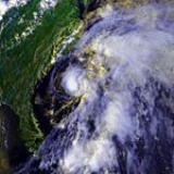
Hurricane Earl
The strongest storm of the season began as a tropical wave off Africa on September 4. After moving across the tropical Atlantic Ocean it strengthened as Tropical Depression Five on September 10 while about 1240 miles (2000 km) east of Puerto RicoPuerto Rico
Puerto Rico , officially the Commonwealth of Puerto Rico , is an unincorporated territory of the United States, located in the northeastern Caribbean, east of the Dominican Republic and west of both the United States Virgin Islands and the British Virgin Islands.Puerto Rico comprises an...
. The depression quickly strengthened and reached hurricane strength on September 11, peaked as a Category 2 hurricane on September 12 as it made a half circle, weakened to a Category 1 on September 16 and bounced back the way it came. Earl then turned north and became extratropical southeast of Newfoundland on September 19. At its peak, Earl had sustained winds of 105 mph (170 km/h) and a minimum central pressure of 979 mbar.
Hurricane Frances
First spotted as a tropical disturbance near the Lesser AntillesLesser Antilles
The Lesser Antilles are a long, partly volcanic island arc in the Western Hemisphere. Most of its islands form the eastern boundary of the Caribbean Sea with the Atlantic Ocean, with the remainder located in the southern Caribbean just north of South America...
on November 15, the system moved generally northward while slowly developing. The system organized into a tropical depression on November 18 and quickly strengthened into a tropical storm. The storm curved northeast and strengthened further, reaching hurricane strength on November 20. However, a surface high-pressure system to the north caused the storm to weaken as the vertical wind shear
Wind shear
Wind shear, sometimes referred to as windshear or wind gradient, is a difference in wind speed and direction over a relatively short distance in the atmosphere...
increased over its center. Frances was later absorbed by an extratropical cyclone
Extratropical cyclone
Extratropical cyclones, sometimes called mid-latitude cyclones or wave cyclones, are a group of cyclones defined as synoptic scale low pressure weather systems that occur in the middle latitudes of the Earth having neither tropical nor polar characteristics, and are connected with fronts and...
on November 21.
Storm names
The following names were used for named storms that formed in the north Atlantic in 1986. No names were retired, so it was used again in the 1992 season1992 Atlantic hurricane season
The 1992 Atlantic hurricane season had one of the latest dates on record for the first named storm. The season officially began on June 1, 1992, and lasted until November 30, 1992. It was the least active hurricane season in nine years due to a strong El Niño...
. This is the same list used for the 1980 season
1980 Atlantic hurricane season
The 1980 Atlantic hurricane season officially began on June 1, 1980, and lasted until November 30, 1980. These dates conventionally delimit the period of each year when most tropical cyclones form in the Atlantic basin. The season was fairly active, with eleven storms forming, of which nine reached...
except for Andrew, which replaced Allen
Hurricane Allen
Hurricane Allen was the first and strongest hurricane of the 1980 Atlantic hurricane season. It was one of the strongest hurricanes in recorded history, one of the few hurricanes to reach Category 5 status on the Saffir-Simpson Hurricane Scale on three separate occasions, and spent more time...
. A storm was named Andrew for the first time in 1986. Names that were not assigned are marked in .
|
Retirement
The World Meteorological OrganizationWorld Meteorological Organization
The World Meteorological Organization is an intergovernmental organization with a membership of 189 Member States and Territories. It originated from the International Meteorological Organization , which was founded in 1873...
retired no names used in the 1986 season.
See also
- List of Atlantic hurricanes
- List of Atlantic hurricane seasons
- 1986 Pacific hurricane season1986 Pacific hurricane seasonThe 1986 Pacific hurricane season was less active than the 1985 Pacific hurricane season. It officially started May 15, 1986 in the eastern Pacific, and June 1, 1986 in the central Pacific, and lasted until November 30, 1986. These dates conventionally delimit the period of each year when almost...
- 1986 Pacific typhoon season1986 Pacific typhoon seasonA total of 32 tropical depressions formed in 1986 in the Western Pacific over an eleven month time span. Of the 32, 30 became tropical storms, 19 storms reached typhoon intensity, and 3 reached super typhoon strength...
- 1986 North Indian Ocean cyclone season
- Southern Hemisphere tropical cyclone seasons: 1985–86, 1986–87