

List of hill forts and ancient settlements in Somerset
Encyclopedia
Somerset
is a ceremonial county
in South West England
. It is a rural county of rolling hills, such as the Mendip Hills
, Quantock Hills
and Exmoor National Park, and large flat expanses of land including the Somerset Levels
. Modern man came to what is now known as Somerset during the Early Upper Palaeolithic era. In the Neolithic
era, from about 3500 BC, there is evidence of farm
ing when people started to manage animals and grow crops on farms cleared from the woodland, rather than act purely as hunter gatherers. It is also likely that extraction and smelting of mineral
ore
s to make tools, weapons, containers and ornaments in bronze
and then iron
started in the late Neolithic and into the Bronze and Iron Ages.
The construction of Hill forts began in Britain in the Late Bronze and Early Iron Age, roughly the start of the first millennium BC
. The reason for their emergence, and their purpose, has been a subject of debate. It has been argued that they could have been military sites constructed in response to invasion from continental Europe
, sites built by invaders, or a military reaction to social tensions caused by an increasing population and consequent pressure on agriculture. The dominant view since the 1960s has been that the increasing use of iron led to social changes in Britain. Deposits of iron ore were separated from the sources of tin and copper necessary to make bronze, and as a result trading patterns shifted and the old elites lost their economic and social status. Archaeologist Barry Cunliffe
believes that population increase played a role and has stated "[the forts] provided defensive possibilities for the community at those times when the stress [of an increasing population] burst out into open warfare. But I wouldn't see them as having been built because there was a state of war. They would be functional as defensive strongholds when there were tensions and undoubtedly some of them were attacked and destroyed, but this was not the only, or even the most significant, factor in their construction".
There are numerous Iron Age hill forts and ancient settlement sites in the county, some of which were later reused in the Dark Ages, such as Cadbury Castle
, Worlebury Camp
and Ham Hill. Other hill forts, such as Small Down Knoll
, Solsbury Hill
, Dolebury Warren
and Burledge Hill
, may have had a domestic purpose as well as a defensive role. The Iron Age tribes of the Somerset area were the Dobunni
in north Somerset, Durotriges
in south Somerset and Dumnonii
in west Somerset. Iron Age sites on the Quantock Hills, include major hill forts at Dowsborough
and Ruborough, as well as smaller earthwork enclosures, such as Trendle Ring
, Elworthy Barrows
and Plainsfield Camp
. In addition to the hill forts, several sites have been identified as settlements during the pre Roman period including Cambria Farm
and the "Lake Villages" at Meare
and Glastonbury
which were built on a morass
, on an artificial foundation of timber filled with brushwood, bracken
, rubble and clay. Most of the sites fell out of use with the coming of the Romans and therefore this list covers those sites occupied until that time.
Scheduled monuments
In the United Kingdom, a Scheduled Monument is a "nationally important" archaeological site
or historic building, given protection against unauthorised change. Scheduled Monuments are specified in the Ancient Monuments and Archaeological Areas Act 1979
, which defines a monument as:
Damage to a scheduled monument is a criminal offence and any work taking place at one of these sites requires Scheduled Monument Consent from the Secretary of State. In England, the Department for Culture, Media and Sport
keeps the register, or schedule, of nationally important sites which receive state protection, which now includes over 31,000 sites.
Somerset
The ceremonial and non-metropolitan county of Somerset in South West England borders Bristol and Gloucestershire to the north, Wiltshire to the east, Dorset to the south-east, and Devon to the south-west. It is partly bounded to the north and west by the Bristol Channel and the estuary of the...
is a ceremonial county
Ceremonial counties of England
The ceremonial counties are areas of England to which are appointed a Lord Lieutenant, and are defined by the government as counties and areas for the purposes of the Lieutenancies Act 1997 with reference to the metropolitan and non-metropolitan counties of England and Lieutenancies Act 1997...
in South West England
South West England
South West England is one of the regions of England defined by the Government of the United Kingdom for statistical and other purposes. It is the largest such region in area, covering and comprising Bristol, Gloucestershire, Somerset, Dorset, Wiltshire, Devon, Cornwall and the Isles of Scilly. ...
. It is a rural county of rolling hills, such as the Mendip Hills
Mendip Hills
The Mendip Hills is a range of limestone hills to the south of Bristol and Bath in Somerset, England. Running east to west between Weston-super-Mare and Frome, the hills overlook the Somerset Levels to the south and the Avon Valley to the north...
, Quantock Hills
Quantock Hills
The Quantock Hills is a range of hills west of Bridgwater in Somerset, England. The Quantock Hills were England’s first Area of Outstanding Natural Beauty being designated in 1956 and consists of large amounts of heathland, oak woodlands, ancient parklands and agricultural land.The hills run from...
and Exmoor National Park, and large flat expanses of land including the Somerset Levels
Somerset Levels
The Somerset Levels, or the Somerset Levels and Moors as they are less commonly but more correctly known, is a sparsely populated coastal plain and wetland area of central Somerset, South West England, between the Quantock and Mendip Hills...
. Modern man came to what is now known as Somerset during the Early Upper Palaeolithic era. In the Neolithic
Neolithic
The Neolithic Age, Era, or Period, or New Stone Age, was a period in the development of human technology, beginning about 9500 BC in some parts of the Middle East, and later in other parts of the world. It is traditionally considered as the last part of the Stone Age...
era, from about 3500 BC, there is evidence of farm
Farm
A farm is an area of land, or, for aquaculture, lake, river or sea, including various structures, devoted primarily to the practice of producing and managing food , fibres and, increasingly, fuel. It is the basic production facility in food production. Farms may be owned and operated by a single...
ing when people started to manage animals and grow crops on farms cleared from the woodland, rather than act purely as hunter gatherers. It is also likely that extraction and smelting of mineral
Mineral
A mineral is a naturally occurring solid chemical substance formed through biogeochemical processes, having characteristic chemical composition, highly ordered atomic structure, and specific physical properties. By comparison, a rock is an aggregate of minerals and/or mineraloids and does not...
ore
Ore
An ore is a type of rock that contains minerals with important elements including metals. The ores are extracted through mining; these are then refined to extract the valuable element....
s to make tools, weapons, containers and ornaments in bronze
Bronze
Bronze is a metal alloy consisting primarily of copper, usually with tin as the main additive. It is hard and brittle, and it was particularly significant in antiquity, so much so that the Bronze Age was named after the metal...
and then iron
Iron
Iron is a chemical element with the symbol Fe and atomic number 26. It is a metal in the first transition series. It is the most common element forming the planet Earth as a whole, forming much of Earth's outer and inner core. It is the fourth most common element in the Earth's crust...
started in the late Neolithic and into the Bronze and Iron Ages.
The construction of Hill forts began in Britain in the Late Bronze and Early Iron Age, roughly the start of the first millennium BC
1st millennium BC
The 1st millennium BC encompasses the Iron Age and sees the rise of many successive empires, and spanned from 1000 BC to 1 BC.The Neo-Assyrian Empire, followed by the Achaemenids. In Greece, Classical Antiquity begins with the colonization of Magna Graecia and peaks with the rise of Hellenism. The...
. The reason for their emergence, and their purpose, has been a subject of debate. It has been argued that they could have been military sites constructed in response to invasion from continental Europe
Continental Europe
Continental Europe, also referred to as mainland Europe or simply the Continent, is the continent of Europe, explicitly excluding European islands....
, sites built by invaders, or a military reaction to social tensions caused by an increasing population and consequent pressure on agriculture. The dominant view since the 1960s has been that the increasing use of iron led to social changes in Britain. Deposits of iron ore were separated from the sources of tin and copper necessary to make bronze, and as a result trading patterns shifted and the old elites lost their economic and social status. Archaeologist Barry Cunliffe
Barry Cunliffe
Sir Barrington Windsor Cunliffe, CBE, known professionally as Barry Cunliffe is a former Professor of European Archaeology at the University of Oxford, a position held from 1972 to 2007...
believes that population increase played a role and has stated "[the forts] provided defensive possibilities for the community at those times when the stress [of an increasing population] burst out into open warfare. But I wouldn't see them as having been built because there was a state of war. They would be functional as defensive strongholds when there were tensions and undoubtedly some of them were attacked and destroyed, but this was not the only, or even the most significant, factor in their construction".
There are numerous Iron Age hill forts and ancient settlement sites in the county, some of which were later reused in the Dark Ages, such as Cadbury Castle
Cadbury Castle, Somerset
Cadbury Castle is an Iron Age hill fort in the civil parish of South Cadbury in the English county of Somerset. It is a Scheduled Ancient Monument and associated with King Arthur.-Background:...
, Worlebury Camp
Worlebury Camp
Worlebury Camp is the name of the place where an Iron Age hill fort once stood atop Worlebury Hill, which is north of the town of Weston-super-Mare in Somerset, England. This fort was designed for defence, as is evidenced the number of walls and ditches around the site. Archaeologists have found...
and Ham Hill. Other hill forts, such as Small Down Knoll
Small Down Knoll
Small Down Knoll, or Small Down Camp, is a Bronze Age hill fort near Evercreech in Somerset, England. The hill is on the southern edge of the Mendip Hills, and rises to 222 m .Finds of flints indicate a prehistoric Mesolithic occupation....
, Solsbury Hill
Solsbury Hill
Little Solsbury Hill is a small flat-topped hill and the site of an Iron Age hill fort. It is located above the village of Batheaston in Somerset, England. The hill rises to above the River Avon which is just over to the south. It is within the Cotswolds Area of Outstanding Natural Beauty...
, Dolebury Warren
Dolebury Warren
Dolebury Warren is a 90.6 hectare biological Site of Special Scientific Interest near the village of Churchill in North Somerset, notified in 1952...
and Burledge Hill
Burledge Hill
Burledge Hill is on the southern edge of the village of Bishop Sutton, Somerset, England. It is the site of a Site of Special Scientific Interest and an univallate Iron Age hillfort.-Site of Special Scientific Interest:...
, may have had a domestic purpose as well as a defensive role. The Iron Age tribes of the Somerset area were the Dobunni
Dobunni
The Dobunni were one of the Celtic tribes living in the British Isles prior to the Roman invasion of Britain. There are seven known references to the tribe in Roman histories and inscriptions. The latter part of the name possibly derives from Bune, a cup or vessel...
in north Somerset, Durotriges
Durotriges
The Durotriges were one of the Celtic tribes living in Britain prior to the Roman invasion. The tribe lived in modern Dorset, south Wiltshire and south Somerset...
in south Somerset and Dumnonii
Dumnonii
The Dumnonii or Dumnones were a British Celtic tribe who inhabited Dumnonia, the area now known as Devon and Cornwall in the farther parts of the South West peninsula of Britain, from at least the Iron Age up to the early Saxon period...
in west Somerset. Iron Age sites on the Quantock Hills, include major hill forts at Dowsborough
Dowsborough
Dowsborough Camp is an Iron Age hill fort on the Quantock Hills near Nether Stowey in Somerset, England. It has been designated as a Scheduled Ancient Monument .-Background:...
and Ruborough, as well as smaller earthwork enclosures, such as Trendle Ring
Trendle Ring
Trendle Ring is an Iron Age earthwork on the Quantock Hills near Bicknoller in Somerset, England. It is a Scheduled Ancient Monument .The word trendle means circle, so it is a tautological place name....
, Elworthy Barrows
Elworthy Barrows
Elworthy Barrows is an unfinished Iron Age hill fort rather than Bronze Age barrows, which has been designated as a Scheduled Ancient Monument . It is located in the civil parish of Brompton Ralph near Wiveliscombe, Somerset, England.-Background:...
and Plainsfield Camp
Plainsfield Camp
Plainsfield Camp is a possible Iron Age earthwork on the Quantock Hills near Aisholt in Somerset, England.The so-called hill fort has several features that make it more likely to be an animal enclosure, than a defended settlement:...
. In addition to the hill forts, several sites have been identified as settlements during the pre Roman period including Cambria Farm
Cambria Farm
Cambria Farm is the site of a Bronze and Iron Age settlement and Roman farm, between Ruishton and Taunton, Somerset, England.A survey of the site was carried by Context One in 2007 out prior to the construction of a Park and ride close to Junction 25 of the M5 motorway. In early 2009 further...
and the "Lake Villages" at Meare
Meare Lake Village
Meare Lake Village is the site of an Iron Age settlement on the Somerset Levels at Meare, Somerset, England. It is a Scheduled Ancient Monument.-Description:...
and Glastonbury
Glastonbury Lake Village
Glastonbury Lake Village was an iron age village on the Somerset Levels near Godney, some north west of Glastonbury, Somerset, England. It has been designated as a Scheduled Ancient Monument and covers an area of north to south by east to west....
which were built on a morass
Marsh
In geography, a marsh, or morass, is a type of wetland that is subject to frequent or continuous flood. Typically the water is shallow and features grasses, rushes, reeds, typhas, sedges, other herbaceous plants, and moss....
, on an artificial foundation of timber filled with brushwood, bracken
Bracken
Bracken are several species of large, coarse ferns of the genus Pteridium. Ferns are vascular plants that have alternating generations, large plants that produce spores and small plants that produce sex cells . Brackens are in the family Dennstaedtiaceae, which are noted for their large, highly...
, rubble and clay. Most of the sites fell out of use with the coming of the Romans and therefore this list covers those sites occupied until that time.
Scheduled monuments
In the United Kingdom, a Scheduled Monument is a "nationally important" archaeological site
Archaeological site
An archaeological site is a place in which evidence of past activity is preserved , and which has been, or may be, investigated using the discipline of archaeology and represents a part of the archaeological record.Beyond this, the definition and geographical extent of a 'site' can vary widely,...
or historic building, given protection against unauthorised change. Scheduled Monuments are specified in the Ancient Monuments and Archaeological Areas Act 1979
Ancient Monuments and Archaeological Areas Act 1979
The Ancient Monuments and Archaeological Areas Act 1979 or AMAAA was a law passed by the British government, the latest in a series of Ancient Monument Acts legislating to protect the archaeological heritage of Great Britain. Northern Ireland has its own legislation.Section 61 defines sites that...
, which defines a monument as:
- Any building, structure or work above or below the surface of the land, any cave or excavation; any site comprising the remains of any such building, structure or work or any cave or excavation; and any site comprising or comprising the remains of any vehicle, vessel or aircraft or other movable structure or part thereof... (Section 61 (7)).
Damage to a scheduled monument is a criminal offence and any work taking place at one of these sites requires Scheduled Monument Consent from the Secretary of State. In England, the Department for Culture, Media and Sport
Department for Culture, Media and Sport
The Department for Culture, Media and Sport is a department of the United Kingdom government, with responsibility for culture and sport in England, and some aspects of the media throughout the whole UK, such as broadcasting and internet....
keeps the register, or schedule, of nationally important sites which receive state protection, which now includes over 31,000 sites.
Known hill forts and settlements
| Site Name Alternative name(s) |
Age | Scheduling Number Scheduled Ancient Monument In the United Kingdom, a scheduled monument is a 'nationally important' archaeological site or historic building, given protection against unauthorized change. The various pieces of legislation used for legally protecting heritage assets from damage and destruction are grouped under the term... |
Plan | Location | Description |
|---|---|---|---|---|---|
| Athelney hill fort Athelney Athelney is located between the villages of Burrowbridge and East Lyng in the Sedgemoor district of Somerset, England. The area is known as the Isle of Athelney, because it was once a very low isolated island in the 'very great swampy and impassable marshes' of the Somerset Levels. Much of the... |
– | Athelney Athelney Athelney is located between the villages of Burrowbridge and East Lyng in the Sedgemoor district of Somerset, England. The area is known as the Isle of Athelney, because it was once a very low isolated island in the 'very great swampy and impassable marshes' of the Somerset Levels. Much of the... 51.0557°N 2.9331°W |
Athelney Hill fort is an Iron Age hill fort near which Alfred the Great Alfred the Great Alfred the Great was King of Wessex from 871 to 899.Alfred is noted for his defence of the Anglo-Saxon kingdoms of southern England against the Vikings, becoming the only English monarch still to be accorded the epithet "the Great". Alfred was the first King of the West Saxons to style himself... hid from the Danes Danes Danish people or Danes are the nation and ethnic group that is native to Denmark, and who speak Danish.The first mention of Danes within the Danish territory is on the Jelling Rune Stone which mentions how Harald Bluetooth converted the Danes to Christianity in the 10th century... after his defeat in 876 AD. The hill fort may also be the site where Alfred defeated the Danes two years later. |
||
| Backwell hill fort Backwell Hillfort Backwell Hillfort is an Iron Age hill fort situated approximately from Backwell in the North Somerset district of Somerset, England. The hill fort was first discovered in 1933 with two of the three sides of the fort protected by a large ditch and a bank... |
194831 | – | Backwell Backwell Backwell is a suburban village and civil parish in Somerset, England. It falls within the Unitary Authority of North Somerset and has a population of 5,455.It is south west of Bristol, on the A370 to Weston-super-Mare... 51.4092°N 2.7289°W |
In 1933, Backwell Camp, an Iron Age hill fort, was discovered. Two of its three sides were protected by a ditch and a bank, with the outside of the bank on the edge of the cliffs upon which the fort was built. However, by 1956, quarrying had almost completely destroyed the site. |
|
| Banwell Camp Banwell Camp Banwell Camp is a univallate Iron Age hill fort in the North Somerset district of Somerset, England. The hill fort is situated approximately east from the town of Banwell. Some artifacts found on the site dates back to the Bronze Age and the Stone Age. In places it is surrounded by a high bank... |
Bronze Age Bronze Age The Bronze Age is a period characterized by the use of copper and its alloy bronze as the chief hard materials in the manufacture of some implements and weapons. Chronologically, it stands between the Stone Age and Iron Age... Iron Age Iron Age The Iron Age is the archaeological period generally occurring after the Bronze Age, marked by the prevalent use of iron. The early period of the age is characterized by the widespread use of iron or steel. The adoption of such material coincided with other changes in society, including differing... |
194460 | – | Banwell Banwell Banwell is a village and civil parish on the River Banwell in the North Somerset district of Somerset, England. Its population was 2,923 according to the 2001 census.-History:... 51.3270°N 2.8496°W |
Banwell Camp is a univallate Iron Age hill fort. Artefacts found in the campsite date back to the Bronze Age Bronze Age The Bronze Age is a period characterized by the use of copper and its alloy bronze as the chief hard materials in the manufacture of some implements and weapons. Chronologically, it stands between the Stone Age and Iron Age... and Stone Age Stone Age The Stone Age is a broad prehistoric period, lasting about 2.5 million years , during which humans and their predecessor species in the genus Homo, as well as the earlier partly contemporary genera Australopithecus and Paranthropus, widely used exclusively stone as their hard material in the... . Some of the older banks in this site are still around 4 metres (13.1 ft) high. |
| Bathampton Camp | Iron Age Iron Age The Iron Age is the archaeological period generally occurring after the Bronze Age, marked by the prevalent use of iron. The early period of the age is characterized by the widespread use of iron or steel. The adoption of such material coincided with other changes in society, including differing... |
203244 | Bathampton Bathampton Bathampton is a village and civil parish east of Bath, England on the south bank of the River Avon. The parish has a population of 1,504.The Kennet and Avon Canal passes through the village and a toll bridge links Bathampton to Batheaston on the north bank of the canal.-History:Bathampton Camp is... 51.3847°N 2.3262°W |
The site of an early Iron Age stock enclosure which may also have been a fort. It was also used as a Roman field system. The site was excavated in the early 1900s and again in the 1950s. Artefacts from the site include human and animal remains, pottery, and flint flakes. | |
| Bat's Castle Bat's Castle Bats Castle is an Iron Age hill fort at the top of a high hill in the parish of Carhampton south south west of Dunster in Somerset, England.The site was identified in 1983 after some schoolboys found eight silver plated coins dating from 102BC to AD350.... Caesar's Camp |
36986 | 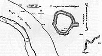 |
Carhampton Carhampton, Somerset Carhampton is a village and civil parish in West Somerset, England, to the east of Minehead.Carhampton civil parish stretches from the Bristol Channel coast inland to Exmoor. The parish has a population of 992 .-History:... 51.1696°N 3.4495°W |
Bat's Castle is an Iron Age hill fort on the highest point of Gallox Hill. Previously, it was known as "Caesar's Camp", and it is possibly associated with Black Ball Camp Black Ball Camp Black Ball Camp is an Iron Age hill fort South West of Dunster, Somerset, England on the northern summit of Gallox Hill. It is a Scheduled Ancient Monument.... . Bat's Castle has two stone ramparts and two ditches. The ramparts are damaged in places due to the number of visitors. |
|
| Berry Castle Berry Castle, Somerset Berry Castle is an early Roman hillslope enclosure in the West Somerset district of Somerset, England. The hill fort is situated approximately west from the village of Luccombe... Bury Camp |
Late Iron Age Iron Age The Iron Age is the archaeological period generally occurring after the Bronze Age, marked by the prevalent use of iron. The early period of the age is characterized by the widespread use of iron or steel. The adoption of such material coincided with other changes in society, including differing... or early Romano-British |
Luccombe Luccombe Luccombe is a village on the south coast of the Isle of Wight near Shanklin. There is some indication of Bronze Age settlements on the top of the nearby hill of Luccombe Down.The Luccombe area features some spectacular cliffs and scenery... 51.1924°N 3.6335°W |
Berry Castle is a hillside enclosure which survives as a series of earthworks. It dates from the late Iron Age or early Romano-British period. |
||
| Black Ball Camp Black Ball Camp Black Ball Camp is an Iron Age hill fort South West of Dunster, Somerset, England on the northern summit of Gallox Hill. It is a Scheduled Ancient Monument.... British Camp |
24003 | – | Dunster Dunster Dunster is a village and civil parish in west Somerset, England, situated on the Bristol Channel coast south-southeast of Minehead and northwest of Taunton. The village has a population of 862 .The village has numerous restaurants and three pubs... 51.1740°N 3.4540°W |
Black Ball Camp is an Iron Age hill fort on the northern summit of Gallox Hill. It is also known as "British Camp" and is possibly associated with Bat's Castle Bat's Castle Bats Castle is an Iron Age hill fort at the top of a high hill in the parish of Carhampton south south west of Dunster in Somerset, England.The site was identified in 1983 after some schoolboys found eight silver plated coins dating from 102BC to AD350.... . It has a 3 metres (10 ft) high rampart and a 2 metres (7 ft) deep ditch. At the beginning of the 20th century, the foundations of a stone tower were visible. |
|
| Blacker's Hill Blacker's Hill Blacker's Hill Chilcompton is an Iron Age hill fort South West of Radstock, Somerset, England. It has been designated as a Scheduled Ancient Monument.... |
29032 | – | Chilcompton Chilcompton Chilcompton is a civil parish and village in Somerset, England, situated in the Mendip Hills two miles south of Midsomer Norton and 2.5 miles south-west of Westfield, close to the A37 .-History:... 51.2493°N 2.5221°W |
This Iron Age promontory hill fort, Blacker's Hill, is roughly rectangular. It covers 6 hectares (14.8 acre) and originally had two ramparts and two ditches, but on the west and south sides, it was defended by the steep drop. In some places, the ramparts are still considerable, but on the north-eastern side, the inner rampart and ditch have been destroyed. There are three gaps, but only the one on the east seems to be original. |
|
| Brean Down hill fort Brean Down Fort Brean Down Fort was built above sea level on the headland at Brean Down, south of Weston-super-Mare, Somerset, England.The site has a long history, because of its prominent position... |
191314 | – | Brean Brean Brean is a village and civil parish between Weston-super-Mare and Burnham-on-Sea in Somerset, England. The name is derived from "Bryn" Brythonic and Modern Welsh for a hill.... 51.3230°N 3.0102°W |
Brean Down is a Bronze Age hill fort situated on a peninsula jutting out into the Bristol Channel Bristol Channel The Bristol Channel is a major inlet in the island of Great Britain, separating South Wales from Devon and Somerset in South West England. It extends from the lower estuary of the River Severn to the North Atlantic Ocean... . In ancient times, there were fields and barrows around the fort. The site is now a National Trust National Trust for Places of Historic Interest or Natural Beauty The National Trust for Places of Historic Interest or Natural Beauty, usually known as the National Trust, is a conservation organisation in England, Wales and Northern Ireland... site. Roman coins have also been found here. |
|
| Brent Knoll Camp Brent Knoll Camp Brent Knoll Camp is an Iron Age Hill fort at Brent Knoll, from Burnham-on-Sea, Somerset, England. It has been designated as a Scheduled Ancient Monument , and is now in the care of the National Trust.... |
192590 | 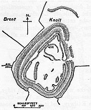 |
Brent Knoll Brent Knoll Brent Knoll is a village in Somerset, England, which lies on the southern edge of Brent Knoll – a hill with a height of 137 metres that dominates the low surrounding landscape of the Somerset Levels.-History:... 51.2543°N 2.9457°W |
The Brent Knoll Camp hill fort is a 1.6 hectares (16,000 m²) Iron Age hill fort that has been heavily damaged by cattle and quarrying. It is defended by a single wall around 10 metres (32.8 ft) high and by a single ditch, with an entrance on the eastern side. An urn Urn An urn is a vase, ordinarily covered, that usually has a narrowed neck above a footed pedestal. "Knife urns" placed on pedestals flanking a dining-room sideboard were an English innovation for high-style dining rooms of the late 1760s... containing coins of the Roman Ancient Rome Ancient Rome was a thriving civilization that grew on the Italian Peninsula as early as the 8th century BC. Located along the Mediterranean Sea and centered on the city of Rome, it expanded to one of the largest empires in the ancient world.... Emperors Trajan Trajan Trajan , was Roman Emperor from 98 to 117 AD. Born into a non-patrician family in the province of Hispania Baetica, in Spain Trajan rose to prominence during the reign of emperor Domitian. Serving as a legatus legionis in Hispania Tarraconensis, in Spain, in 89 Trajan supported the emperor against... and Severus Septimius Severus Septimius Severus , also known as Severus, was Roman Emperor from 193 to 211. Severus was born in Leptis Magna in the province of Africa. As a young man he advanced through the customary succession of offices under the reigns of Marcus Aurelius and Commodus. Severus seized power after the death of... has been found at the site. |
|
| Brewer's Castle Brewer's Castle Brewer's Castle is a defended Iron Age settlement in the West Somerset district of Somerset, England. The hill fort is situated approximately west from the town of Dulverton.The settlement survives as an earthwork situated on Hawkridge Ridge Wood... |
Iron Age Iron Age The Iron Age is the archaeological period generally occurring after the Bronze Age, marked by the prevalent use of iron. The early period of the age is characterized by the widespread use of iron or steel. The adoption of such material coincided with other changes in society, including differing... |
35635 | Dulverton Dulverton Dulverton is a town and civil parish in the heart of West Somerset, England, near the border with Devon. The town has a population of 1,630. The parish includes the hamlets of Battleton and Ashwick which is located approximately north west of Dulverton... 51.0563°N 3.5949°W |
Brewer's Castle, in Hawkridge Wood was an Iron Age defended settlement or hillfort. It is very close to Mounsey Castle Mounsey Castle Mounsey Castle is an Iron Age irregular triangular earthwork of north west of Dulverton, Somerset, England. It is a Scheduled Ancient Monument .It is surrounded by the remains of coursed stone walling, with an entrance to the west.... . |
|
| Broomfield Camp Broomfield Camp Broomfield Camp is a univallate Iron Age hill fort in the Taunton Deane district of Somerset, England. The hill fort is situated approximately south-east from the village of Broomfield. Broomfield Camp dates from late prehistoric or Roman times... Higher Castles enclosure |
Late Prehistoric and/or Roman | Broomfield Broomfield, Somerset Broomfield is a village and civil parish in the Sedgemoor district of Somerset, England, situated about five miles north of Taunton. According to the 2001 census it had a population of 224.... 51.0824°N 3.1199°W |
The univallate enclosure site at Broomfield dates from late prehistoric or Roman times. Archeological excavations in 1968 uncovered a trench through a bank and ditch which produced Iron Age pottery. |
||
| Burgh Walls Camp Burgh Walls Camp Burgh Walls Camp is a multivallate Iron Age hill fort in the North Somerset district of Somerset, England. The hill fort is situated within Leigh Woods approximately north-east from the village of Long Ashton near Bristol, above the banks of the River Avon... |
198387 | – | Long Ashton Long Ashton Long Ashton is a village and civil parish in Somerset, England. It falls within the Unitary Authority of North Somerset, a few miles south west of the city of Bristol. The parish has a population of 4,981... 51.4515°N 2.6278°W |
Burgh Walls Camp is a multivallate Iron Age hill fort on the banks above the River Avon, near where it is now crossed by the Clifton Suspension Bridge. It is also called "Bower Walls Camp", "Burwalls", or "Bowre Walls". |
|
| Burledge hill fort | 197270 | – | Bishop Sutton Bishop Sutton Bishop Sutton is a small village within the Chew Valley in Somerset. It lies south of Chew Valley Lake and north of the Mendip Hills, approximately ten miles south of Bristol on the A368, Weston-super-Mare to Bath road... 51.3232°N 2.6012°W |
Burledge hill fort is an univallate Iron Age hill fort situated on a promontory Promontory Promontory may refer to:*Promontory, a prominent mass of land which overlooks lower lying land or a body of water*Promontory, Utah, the location where the United States first Transcontinental Railroad was completed... . The eastern side, the one with the most gradual slope, has an extra wall across it. Several pieces of clay found with iron slag Slag Slag is a partially vitreous by-product of smelting ore to separate the metal fraction from the unwanted fraction. It can usually be considered to be a mixture of metal oxides and silicon dioxide. However, slags can contain metal sulfides and metal atoms in the elemental form... indicate that the people who lived there may have smelted Smelting Smelting is a form of extractive metallurgy; its main use is to produce a metal from its ore. This includes iron extraction from iron ore, and copper extraction and other base metals from their ores... iron. |
|
| Burrington Camp Burrington Camp Burrington Camp, also known as Burrington Ham, is a Iron Age hill fort in the North Somerset district of Somerset, England. The hill fort is situated in the Mendip Hills approximately south from the village of Burrington.... |
Iron Age Iron Age The Iron Age is the archaeological period generally occurring after the Bronze Age, marked by the prevalent use of iron. The early period of the age is characterized by the widespread use of iron or steel. The adoption of such material coincided with other changes in society, including differing... |
194391 | – | Burrington Combe Burrington Combe Burrington Combe is a carboniferous limestone gorge near the village of Burrington, on the north side of the Mendip Hills Area of Outstanding Natural Beauty, in North Somerset, England.... 51.3214°N 2.7505°W |
Archaeological discoveries of early cemeteries show that humans occupied the combe and its caves from the Bronze Age Bronze Age The Bronze Age is a period characterized by the use of copper and its alloy bronze as the chief hard materials in the manufacture of some implements and weapons. Chronologically, it stands between the Stone Age and Iron Age... with some evidence of occupation during the Upper Palaeolithic period. There is also a sub-rectangular Iron Age univallate hill fort. |
| Bury Castle Bury Castle, Somerset Bury Castle is an Iron Age hill fort and 12th medieval century castle near Selworthy, Somerset, England.-Iron Age:Bury Castle was built as a promontory fort, situated over the meeting of the River Exe and River Haddeo. Hill forts developed in the Late Bronze and Early Iron Age, roughly the start of... |
36765 | Selworthy Selworthy Selworthy is a small village and civil parish from Minehead in Somerset, England. It is located in the National Trust's Holnicote Estate on the northern fringes of Exmoor. The parish includes the hamlets of Bossington, Tivington, Lynch, Brandish Street and Allerford.At Selworthy Beacon, which is... 51.2132°N 3.5511°W |
Bury Castle is a promontory fort Promontory fort A promontory fort is a defensive structure located above a steep cliff, often only connected to the mainland by a small neck of land, thus utilizing the topography to reduce the ramparts needed. Although their dating is problematic, most seem to date to the Iron Age... that encloses an area of 0.2 hectare (0.494210326030552 acre). The main enclosure is encompassed by a single rampart and ditch, with steep drops on the north, east, and south sides. There is an additional rampart 30 metres (98 ft) to the west, with a deep ditch. The rampart is brevetted with drystone walling. |
||
| Cadbury Camp Cadbury Camp Cadbury Camp is an Iron Age hill fort in Somerset, England, near the village of Tickenham. Local legends associate it with Arthurian England and Camelot, though these may be due to confusion with the better-known Cadbury Castle, near South Cadbury some 50 miles to the south. The hill fort is well... |
Bronze Age Bronze Age The Bronze Age is a period characterized by the use of copper and its alloy bronze as the chief hard materials in the manufacture of some implements and weapons. Chronologically, it stands between the Stone Age and Iron Age... Neolithic Period |
195367 |  |
Tickenham Tickenham Tickenham is a village and civil parish near Clevedon and Nailsea, North Somerset, England. The parish has a population of 909. It has a primary school and a village hall, but no shops, although it formerly had a post office.... 51.4485°N 2.7868°W |
Cadbury Camp is an Iron Age hill fort that encloses around 7 acres (28,328 m²). The banks surrounding this site are around 10 feet (3 m) to 12 feet (3.7 m) above the neighbouring ditches. A Romano-British shrine Shrine A shrine is a holy or sacred place, which is dedicated to a specific deity, ancestor, hero, martyr, saint, daemon or similar figure of awe and respect, at which they are venerated or worshipped. Shrines often contain idols, relics, or other such objects associated with the figure being venerated.... , a Bronze Age Bronze Age The Bronze Age is a period characterized by the use of copper and its alloy bronze as the chief hard materials in the manufacture of some implements and weapons. Chronologically, it stands between the Stone Age and Iron Age... spearhead, and Neolithic Neolithic The Neolithic Age, Era, or Period, or New Stone Age, was a period in the development of human technology, beginning about 9500 BC in some parts of the Middle East, and later in other parts of the world. It is traditionally considered as the last part of the Stone Age... flake tools have been found inside the hill fort. |
| Cadbury Castle Cadbury Castle, Somerset Cadbury Castle is an Iron Age hill fort in the civil parish of South Cadbury in the English county of Somerset. It is a Scheduled Ancient Monument and associated with King Arthur.-Background:... Cadbury Camelot Cadenbyrig |
22904 | 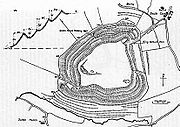 |
South Cadbury South Cadbury South Cadbury is a village and civil parish in the South Somerset council area of the English county of Somerset. The parish includes the village of Sutton Montis... 51.0241°N 2.5318°W |
Cadbury Castle was fortified into a hill fort somewhere between 500 and 200 BC, and it encloses an area of 8 hectares (80,000 m²). The site is associated with King Arthur King Arthur King Arthur is a legendary British leader of the late 5th and early 6th centuries, who, according to Medieval histories and romances, led the defence of Britain against Saxon invaders in the early 6th century. The details of Arthur's story are mainly composed of folklore and literary invention, and... . |
|
| Cadbury Hill Cadbury Hill Cadbury Hill is a small hill, mostly in the civil parish of Congresbury, overlooking the village of Yatton in North Somerset. On its summit stands an Iron Age hill fort, which is a Scheduled Ancient Monument.-Background:... Cadbury-Congresbury |
195114 | – | Congresbury Congresbury Congresbury is a village and civil parish in Somerset, England. It is situated in the Unitary authority of North Somerset, and in 2001 had a population of 3,400. It lies on the A370, roughly equidistant between Junction 21 of the M5 and Bristol Airport, approximately south of Bristol city centre,... 51.3804°N 2.8032°W |
This hill fort is known, in archaeological circles, as Cadbury-Congresbury in order to differentiate it from the Cadbury Castle Cadbury Castle, Somerset Cadbury Castle is an Iron Age hill fort in the civil parish of South Cadbury in the English county of Somerset. It is a Scheduled Ancient Monument and associated with King Arthur.-Background:... . It appears to have been constructed during the Iron Age, and the remains of Iron Age roundhouses Roundhouse (dwelling) The roundhouse is a type of house with a circular plan, originally built in western Europe before the Roman occupation using walls made either of stone or of wooden posts joined by wattle-and-daub panels and a conical thatched roof. Roundhouses ranged in size from less than 5m in diameter to over 15m... may still be seen inside. The hill fort was refortified around 400 BC and occupation extended into the sub-Roman Sub-Roman Britain Sub-Roman Britain is a term derived from an archaeological label for the material culture of Britain in Late Antiquity: the term "Sub-Roman" was invented to describe the potsherds in sites of the 5th century and the 6th century, initially with an implication of decay of locally-made wares from a... period, from which much imported pottery has been recovered. It has been suggested that this was the monastery of Saint Congar Congar of Congresbury Saint Congar , was a Welsh abbot and supposed bishop in Somerset, now in England.... after whom Congresbury was named. |
|
| Cambria Farm Cambria Farm Cambria Farm is the site of a Bronze and Iron Age settlement and Roman farm, between Ruishton and Taunton, Somerset, England.A survey of the site was carried by Context One in 2007 out prior to the construction of a Park and ride close to Junction 25 of the M5 motorway. In early 2009 further... |
190630 | – | Ruishton Ruishton Ruishton is a village and civil parish in Somerset, England, situated on the River Tone and A358 road east of Taunton in the Taunton Deane district. The village has a population of 1,389... 51.0160°N 3.0606°W |
Cambria Farm is the site of a burned Bronze Age Bronze Age The Bronze Age is a period characterized by the use of copper and its alloy bronze as the chief hard materials in the manufacture of some implements and weapons. Chronologically, it stands between the Stone Age and Iron Age... mound and Iron Age roundhouse Roundhouse A roundhouse is a building used by railroads for servicing locomotives. Roundhouses are large, circular or semicircular structures that were traditionally located surrounding or adjacent to turntables... s. |
|
| Cannington Camp Cannington Camp Cannington Camp is a Bronze Age and Iron Age hill fort near Cannington, Somerset, England. It is a Scheduled Ancient Monument.The small hill rises to above low lying land about west of the tidal estuary of the River Parrett, near the ancient port and ford at Combwich... Cynwit Castle |
and Iron Age Iron Age The Iron Age is the archaeological period generally occurring after the Bronze Age, marked by the prevalent use of iron. The early period of the age is characterized by the widespread use of iron or steel. The adoption of such material coincided with other changes in society, including differing... |
191244 | 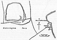 |
Cannington Cannington, Somerset Cannington is a village and civil parish north-west of Bridgwater in the Sedgemoor district of Somerset, England. It lies on the west bank of the River Parret, and contains the hamlet of Edstock.-History:... 51.1588°N 3.0796°W |
Cannington Camp is a univallate hill fort with walls that have been almost entirely destroyed. Archaeological artefact Artifact (archaeology) An artifact or artefact is "something made or given shape by man, such as a tool or a work of art, esp an object of archaeological interest"... s such as stone scrapers, cores, and flakes have been found at the site. |
| Castle Neroche hill fort Castle Neroche Castle Neroche is a Norman motte-and-bailey castle on the site of an earlier hill fort in the parish of Curland, near Staple Fitzpaine, Somerset, England. It is a Scheduled Ancient Monument.-Location:... |
190295 | 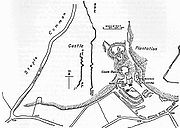 |
Staple Fitzpaine Staple Fitzpaine Staple Fitzpaine is a village and civil parish in Somerset, England, situated south of Taunton in the Taunton Deane district. The village has a population of 151 and is within the Blackdown Hills Area of Outstanding Natural Beauty... 50.9370°N 3.0374°W |
There are several bank-and-ditch earthworks Earthworks (archaeology) In archaeology, earthwork is a general term to describe artificial changes in land level. Earthworks are often known colloquially as 'lumps and bumps'. Earthworks can themselves be archaeological features or they can show features beneath the surface... near Castle Neroche, indicating the presence of a hill fort at some point during the 1st millennium BC. |
|
| Clatworthy Camp Clatworthy Camp Clatworthy Camp is an Iron Age hill fort North West of Wiveliscombe, Somerset, England. It has been designated as a Scheduled Ancient Monument.... |
188442 | – | Wiveliscombe Wiveliscombe Wiveliscombe is a town and civil parish in Somerset, England, situated west of Taunton in the Taunton Deane district. The town has a population of 2,670. The parish includes the nearby hamlet of Maundown.-History:... 51.0743°N 3.3652°W |
Clatworthy Camp is an Iron Age hill fort situated on a promentory of the Brendon Hills Brendon Hills The Brendon Hills are composed of a lofty ridge of hills in the East Lyn Valley area of western Somerset, England. The terrain is broken by a series of deeply incised streams and rivers running roughly southwards to meet the River Haddeo, a tributary of the River Exe.The hills are quite heavily... above Clatworthy Reservoir Clatworthy Reservoir Clatworthy Reservoir is situated near Clatworthy in the Brendon Hills on the edge of the Exmoor National Park in west Somerset, England. It is run by Wessex Water and has a capacity of , supplying some 200,000 homes... . It is roughly triangular in shape with an area of 5.8 hectares (14.3 acre). It has a single bank and ditch, cut through solid rock. There may have been an entrance on the west and two on the east. |
|
| Cleeve Toot Cleeve Toot Cleeve Toot is an Iron Age hillfort above Goblin Combe, Cleeve, Somerset, England. It is a Scheduled Ancient Monument.It is a roughly oval settlement which is approximately in length by in breadth. Approximately to the north is another, smaller settlement... Cleeve Hill hill fort |
194816 | – | Cleeve Cleeve, Somerset Cleeve is a village and civil parish in the ceremonial county of Somerset, England. It is situated within the unitary authority of North Somerset, south west of Bristol and has a population of 941 .-History:... 51.3878°N 2.7731°W |
Cleeve Toot, close to the village of Cleeve Cleeve, Somerset Cleeve is a village and civil parish in the ceremonial county of Somerset, England. It is situated within the unitary authority of North Somerset, south west of Bristol and has a population of 941 .-History:... , is a roughly oval settlement which is approximately 125 metres (410.1 ft) in length by 90 metres (295.3 ft) in breadth. Approximately 150 metres (492.1 ft) to the north is another, smaller settlement. |
|
| Conygar hill fort Conygar Hillfort Conygar Hillfort is a small multivallate Iron Age hill fort in the North Somerset district of Somerset, England. It is a Scheduled Ancient Monument.The hill fort is situated approximately south from the village of Portbury near Bristol and the M5.... |
195214 | – | Portbury Portbury Portbury is a village and civil parish in Somerset, England within the Unitary Authority of North Somerset.The parish includes the hamlet of Sheepway which is situated on the moorland at the northern edge of the Gordano valley, between the Gordano services on the M5 motorway and Portishead, near... 51.4732°N 2.7223°W |
Conygar hill fort is a small Iron Age univallate hill fort. The fort is triangular in shape and there are the remains of a three foot high bank on the south-western side. There is a round barrow in the centre of the fort. |
|
| Cow Castle Cow Castle Cow Castle is an Iron Age hill fort West South West of Exford, Somerset, England within the Exmoor National Park. It is a Scheduled Ancient Monument.... |
34989 | – | Exford Exford, Somerset Exford is a rural village at the centre of Exmoor, north-west of Dulverton, and south-west of Minehead, in Somerset, England. Less than a mile away is the hamlet of Lyncombe.... 51.1226°N 3.7253°W |
Cow Castle is an Iron Age hill fort occupying an isolated hilltop and has a single rampart and ditch, enclosing 0.9 hectares (2.2 acre). It is in the valley of the River Barle River Barle The River Barle runs from the Chains on northern Exmoor, in Somerset, England to join the River Exe at Exebridge, Devon. The river and the Barle Valley are both designated as biological Site of Special Scientific Interest.... . |
|
| Curdon Camp Curdon Camp Curdon Camp is a univallate Iron Age hill fort in the West Somerset district of Somerset, England. It is a Scheduled Ancient Monument.The hill fort is situated approximately north-west from the village of Stogumber. The camp was nearly completely destroyed by quarrying and bulldozing... |
189556 | – | Stogumber Stogumber Stogumber is a village and civil parish in Somerset, England, on the eastern flank of the Brendon Hills. Besides Stogumber village itself, the parish includes the hamlets of Ashbeer, Capton, Escott, Higher Vexford, Kingswood, Lower Vellow, Lower Vexford, Preston, and Vellow.-History:The name comes... 51.1387°N 3.2850°W |
Curdon Camp has been almost completely destroyed by quarrying and bulldozing. A section remains that is still 2.5 metres (8.2 ft) high on the southern and western sides. |
|
| Dinghurst fort Dinghurst fort Dinghurst fort is an Iron Age univallate hillfort south of Churchill in Somerset, England. A scarp encircles the camp, high in the east and high in the west. The fort is also surrounded by a fosse. Bones, rings, and weapons have been found inside the fort.... |
194536 | – | Churchill Churchill, Somerset Churchill is a village and civil parish in Somerset, England. It is located in the unitary authority of North Somerset, on the western edge of the Mendip Hills about east of Weston-super-Mare... 51.3347°N 2.7982°W |
Dinghurst fort is the possible site of an Iron Age univallate hill fort. Close to Dolebury Warren Dolebury Warren Dolebury Warren is a 90.6 hectare biological Site of Special Scientific Interest near the village of Churchill in North Somerset, notified in 1952... . |
|
| Dolebury Warren Dolebury Warren Dolebury Warren is a 90.6 hectare biological Site of Special Scientific Interest near the village of Churchill in North Somerset, notified in 1952... Dolebury Camp |
194279 | 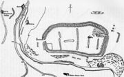 |
Churchill Churchill, Somerset Churchill is a village and civil parish in Somerset, England. It is located in the unitary authority of North Somerset, on the western edge of the Mendip Hills about east of Weston-super-Mare... 51.3265°N 2.7907°W |
Dolebury Camp is a hill fort located on a ridge in the Mendip Hills Mendip Hills The Mendip Hills is a range of limestone hills to the south of Bristol and Bath in Somerset, England. Running east to west between Weston-super-Mare and Frome, the hills overlook the Somerset Levels to the south and the Avon Valley to the north... 47 metres (154.2 ft) above the surrounding area. The walls enclose an area of 9 hectares (22.2 acre), with the maximum height of 9 metres (29.5 ft) on the northern side. |
|
| Dowsborough Dowsborough Dowsborough Camp is an Iron Age hill fort on the Quantock Hills near Nether Stowey in Somerset, England. It has been designated as a Scheduled Ancient Monument .-Background:... Dowsborough Castle hill fort Dowsborough Camp or Danesborough or Dawesbury |
24007 | 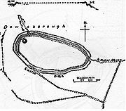 |
Holford Holford Holford is a village and civil parish in West Somerset within the Quantock Hills Area of Outstanding Natural Beauty, and about west of Bridgwater and east of Williton. The village has a population of about 200. The village is on the Quantock Greenway and Coleridge Way footpaths... 51.1454°N 3.2015°W |
Dowsborough is an oval univallate hill fort. The surrounding bank is around 1 metres (3.3 ft) to 1.5 metres (4.9 ft) wide and around 1.2 metres (3.9 ft) high. There is a ditch outside the bank, and the distance from the bottom of the ditch to the top of the bank is around 2 metres (6.6 ft) to 3 metres (9.8 ft). Near the entrance to the hill fort are two structures that are probably gatehouse Gatehouse A gatehouse, in architectural terminology, is a building enclosing or accompanying a gateway for a castle, manor house, fort, town or similar buildings of importance.-History:... s. |
|
| Dundon Hill hill fort Dundon Hill Hillfort Dundon Hill Hillfort is an Iron Age hillfort in Compton Dundon, Somerset, England. It has been designated as a Scheduled Ancient Monument. South east of the site is a Bronze Age bowl barrow which was later modified as a Norman Motte, known as Dundon Beacon.... |
194013 | Compton Dundon Compton Dundon Compton Dundon is a village and civil parish in Somerset, England, situated beside King's Sedge Moor and the Polden Hills, south of Glastonbury and north of Somerton in the South Somerset district. The village has a population of 710... 51.0868°N 2.7381°W |
Dundon Hill hill fort is an Iron Age hill fort guarded by a single bank ranging from 0.5 metres (1.6 ft) to 2.5 metres (8.2 ft) high. Flint Flint Flint is a hard, sedimentary cryptocrystalline form of the mineral quartz, categorized as a variety of chert. It occurs chiefly as nodules and masses in sedimentary rocks, such as chalks and limestones. Inside the nodule, flint is usually dark grey, black, green, white, or brown in colour, and... flakes, Bronze Age Bronze Age The Bronze Age is a period characterized by the use of copper and its alloy bronze as the chief hard materials in the manufacture of some implements and weapons. Chronologically, it stands between the Stone Age and Iron Age... pottery, and Iron Age pottery have also been found. |
||
| Elborough Hill Elborough Hill Elborough Hill is an univallate Iron Age hill fort situated approximately east from the small village of Hutton and south from the village of Elborough in the North Somerset district of Somerset, England... |
192359 | – | Hutton, Somerset Hutton, Somerset Hutton is a village and civil parish in Somerset, England. The parish, which has a population of 2,627, is within the Unitary Authority of North Somerset and located on the western edge of the Mendip Hills, close to Weston-super-Mare.... 51.3202°N 2.9062°W |
Elborough Hill is the site of a bivallate hill fort, oval in shape, and defined by a triple bank on the northern side and a double out-turned bank on the southern side. |
|
| Elworthy Barrows Elworthy Barrows Elworthy Barrows is an unfinished Iron Age hill fort rather than Bronze Age barrows, which has been designated as a Scheduled Ancient Monument . It is located in the civil parish of Brompton Ralph near Wiveliscombe, Somerset, England.-Background:... |
188401 | Brompton Ralph Brompton Ralph Brompton Ralph is a village and civil parish in the West Somerset district of Somerset, England, about west of Taunton, and north of Wiveliscombe. It is in a wooded district at the eastern extremity of the Brendon Hills... 51.0959°N 3.3295°W |
Elworthy Barrows is a heavily damaged circular hill fort which had never been finished. It was plough Plough The plough or plow is a tool used in farming for initial cultivation of soil in preparation for sowing seed or planting. It has been a basic instrument for most of recorded history, and represents one of the major advances in agriculture... ed multiple times until around 1943, when artifacts Artifact (archaeology) An artifact or artefact is "something made or given shape by man, such as a tool or a work of art, esp an object of archaeological interest"... were discovered. |
||
| Glastonbury Lake Village Glastonbury Lake Village Glastonbury Lake Village was an iron age village on the Somerset Levels near Godney, some north west of Glastonbury, Somerset, England. It has been designated as a Scheduled Ancient Monument and covers an area of north to south by east to west.... |
194156 | – | Glastonbury Glastonbury Glastonbury is a small town in Somerset, England, situated at a dry point on the low lying Somerset Levels, south of Bristol. The town, which is in the Mendip district, had a population of 8,784 in the 2001 census... 51.1633°N 2.7264°W |
Glastonbury Lake Village is an Iron Age lake village in Glastonbury Glastonbury Glastonbury is a small town in Somerset, England, situated at a dry point on the low lying Somerset Levels, south of Bristol. The town, which is in the Mendip district, had a population of 8,784 in the 2001 census... . Each house was built on its own mound of clay in the lake, starting around 250 BC and continuing for at least 150 years. The entire settlement is surrounded by a pallisade made of timbers. |
|
| Glastonbury Tor Glastonbury Tor Glastonbury Tor is a hill at Glastonbury, Somerset, England, which features the roofless St. Michael's Tower. The site is managed by the National Trust. It has been designated as a Scheduled Ancient Monument .... |
196702 | – | Glastonbury Glastonbury Glastonbury is a small town in Somerset, England, situated at a dry point on the low lying Somerset Levels, south of Bristol. The town, which is in the Mendip district, had a population of 8,784 in the 2001 census... 51.1446°N 2.7004°W |
Paleolithic Paleolithic The Paleolithic Age, Era or Period, is a prehistoric period of human history distinguished by the development of the most primitive stone tools discovered , and covers roughly 99% of human technological prehistory... , Mesolithic Mesolithic The Mesolithic is an archaeological concept used to refer to certain groups of archaeological cultures defined as falling between the Paleolithic and the Neolithic.... , and Neolithic Neolithic The Neolithic Age, Era, or Period, or New Stone Age, was a period in the development of human technology, beginning about 9500 BC in some parts of the Middle East, and later in other parts of the world. It is traditionally considered as the last part of the Stone Age... flint tools have been found at Glastonbury Tor, which indicates that the site may have been occupied in the Stone Age. It is very close to the Glastonbury Lake Village, which was occupied in the Iron Age, starting around 250 BC. |
|
| Grabbist hill fort Grabbist Hillfort Grabbist hillfort is an Iron Age oval hillfort west of Dunster in Somerset, England. The fort is long and wide, and is surrounded by a counterscarp, which measures in height. It is also surrounded by a ditch, which ranges up to wide and deep... |
36851 | – | Dunster Dunster Dunster is a village and civil parish in west Somerset, England, situated on the Bristol Channel coast south-southeast of Minehead and northwest of Taunton. The village has a population of 862 .The village has numerous restaurants and three pubs... 51.1832°N 3.4565°W |
Oval shape measuring 886 feet (270.1 m) by 220 feet (67.1 m), surrounded by a bank and ditch. |
|
| Ham Hill hill fort Ham Hill Hillfort Ham Hill Hillfort is an Iron Age hillfort located on Ham Hill, Somerset, England. It was also occupied during the mesolithic and neolithic periods and later during Roman and medieval eras... |
1043362 |  |
Ham Hill 50.9483°N 2.7416°W |
The Iron Age hill fort located on Ham Hill, called Ham Hill hill fort, is possibly the largest hill fort in Somerset. It measures 800 metres (2,624.7 ft) by 950 metres (3,116.8 ft), enclosing an area of 81 hectares (200.2 acre). Ham Hill hill fort is surrounded by banks, some of which range up to 12 metres (39.4 ft) high, and ditches. In addition to the Iron Age hill fort, the site was occupied during the Mesolithic Period, the Neolithic Period, and the Bronze Age Bronze Age The Bronze Age is a period characterized by the use of copper and its alloy bronze as the chief hard materials in the manufacture of some implements and weapons. Chronologically, it stands between the Stone Age and Iron Age... . The site has also been damaged by quarrying. |
|
| Highbury Hill Highbury Hill, Clutton Highbury Hill in Clutton, Somerset, England is the site of the earthwork remains of an Iron Age univallate hillfort. It occupies an area of woodland at the end of a narrow ridge. It is a Scheduled Ancient Monument.... |
200574 | – | Clutton, Somerset Clutton, Somerset Clutton is a village and civil parish within the Chew Valley in Somerset in the Bath and North East Somerset Council area on the A37 road. It is located 10 miles from Bristol and Bath, very near Temple Cloud. The nearest town is Midsomer Norton... 51.3194°N 2.5243°W |
On Highbury Hill lies the earthwork remains of an Iron Age univallate hill fort. It occupies an area of woodland at the end of a narrow ridge. |
|
| Kenwalch's Castle Kenwalch's Castle Kenwalch's Castle is probably an Iron Age hill fort that may have been converted into a Roman fortress in Penselwood, Somerset, England, East South East of Bruton at . It is situated in Castle Wood which covers its defences and interior. The latter has an area of . There is a single rampart and... |
202653 | Penselwood Penselwood Penselwood is a village and civil parish in the English county of Somerset. It is located north east of Wincanton, south east of Bruton, west of Mere, and north west of Gillingham. The south-east of the parish borders Zeals and Stourhead in Wiltshire, and Bourton in Dorset... 51.1006°N 2.3619°W |
Kenwalch's Castle is an Iron Age hill fort. The latter has an area of 1.6 hectares (4 acre). There is a single rampart and ditch which are well preserved in places. The road north from Penselwood village crosses the hill fort and probably passes through the original entrances. |
||
| King's Castle King's Castle, Somerset King's Castle is a univallate Iron Age hill fort in the Taunton Deane district of Somerset, England. It is a Scheduled Ancient Monument. The hill fort is guarded by two banks and a ditch. The interior bank is from to high and around thick... |
Iron Age Iron Age The Iron Age is the archaeological period generally occurring after the Bronze Age, marked by the prevalent use of iron. The early period of the age is characterized by the widespread use of iron or steel. The adoption of such material coincided with other changes in society, including differing... |
24024 | Wells Wells Wells is a cathedral city and civil parish in the Mendip district of Somerset, England, on the southern edge of the Mendip Hills. Although the population recorded in the 2001 census is 10,406, it has had city status since 1205... 51.2084°N 2.6191°W |
King's Castle is the remains of an Iron Age settlement and field system. |
|
| Kingsdown Camp Kingsdown Camp Kingsdown Camp is an Iron Age hill fort at Buckland Dinham South East of Radstock, Somerset, England. It is a Scheduled Ancient Monument.It is a univallate fort with an area of , and is approximately quadrilateral in shape. In the Iron Age or Roman period a drystone wall was constructed, possibly... |
203188 | – | Buckland Dinham Buckland Dinham Buckland Dinham is a small village near Frome in Somerset, England. The village has a population of 379. The village's main industry is farming , but the village is also a dormitory village for the nearby cities of Bath and Bristol.-History:... 51.2642°N 2.4034°W |
Kingsdown Camp is a univallate hill fort with an area of 0.15 hectare (0.370657744522914 acre), and is approximately quadrilateral in shape. In the Iron Age or Roman period a drystone wall was constructed, possibly 4 metres (13 ft) high and 2.5 metres (8 ft) wide. There is an entrance on the northeast side. The fort continued to be used by the Romans. |
|
| King's Castle hill fort King's Castle Hillfort King's Castle is a Neolithic hillfort east of Wiveliscombe in Somerset, England. It is surrounded by two banks with a ditch between them. The inner wall ranges up to high and the outer wall gets up to high. Arrowheads, scrapers, and borers have been found at the site... |
188200 | Wiveliscombe Wiveliscombe Wiveliscombe is a town and civil parish in Somerset, England, situated west of Taunton in the Taunton Deane district. The town has a population of 2,670. The parish includes the nearby hamlet of Maundown.-History:... 51.0460°N 3.2895°W |
King's Castle hill fort is guarded by two banks and a ditch. The interior bank is from 2.5 metres (8.2 ft) to 6 metres (19.7 ft) high and around 14 metres (45.9 ft) thick. Several Neolithic Neolithic The Neolithic Age, Era, or Period, or New Stone Age, was a period in the development of human technology, beginning about 9500 BC in some parts of the Middle East, and later in other parts of the world. It is traditionally considered as the last part of the Stone Age... artefact Artifact (archaeology) An artifact or artefact is "something made or given shape by man, such as a tool or a work of art, esp an object of archaeological interest"... s have also been found on the site. |
||
| Maesbury Castle Maesbury Castle Maesbury Castle is an Iron Age hill fort within the parish of Croscombe on the Mendip Hills, just north of Shepton Mallet, Somerset, England. It has been listed as Scheduled Ancient Monument.... |
200279 | Croscombe Croscombe Croscombe is a village and civil parish west of Shepton Mallet and from Wells, in the Mendip district of Somerset, England. It is situated on the A371 road in the valley of the River Sheppey.... 51.2227°N 2.5598°W |
The Maesbury Castle hill fort is a bivallate hill fort with a bank around 1.5 metres (4.9 ft) to 3 metres (9.8 ft) high enclosing an area of around 2.8 hectares (6.9 acre). A second bank around 30 centimetre (0.984251968503937 ft) high exists on the southeastern side. |
||
| Maes Knoll Maes Knoll Maes Knoll is an Iron Age hillfort in Somerset, England, located at the eastern end of the Dundry Down ridge, south of the city of Bristol and north of the village of Norton Malreward near the eastern side of Dundry Hill... Maes Trump |
201029 | Norton Malreward Norton Malreward Norton Malreward is a small Somerset village and civil parish south of Bristol, England at the northern edge of the Chew Valley. In 1895 Norton Malreward was combined with the neighbouring hamlet of Norton Hawkfield or Hautville into a single parish, which has a population of 241.- History :Norton... 51.3916°N 2.5763°W |
Maes Knoll hill fort is roughly triangular, and encloses an area of 8 hectares (19.8 acre). |
||
| Meare Lake Village Meare Lake Village Meare Lake Village is the site of an Iron Age settlement on the Somerset Levels at Meare, Somerset, England. It is a Scheduled Ancient Monument.-Description:... |
194185 | – | Meare Meare Meare is a village and civil parish north west of Glastonbury on the Somerset Levels, in the Mendip district of Somerset, England. The parish includes the village of Westhay.-History:... 51.1760°N 2.7944°W |
Archaeologists uncovered several hearth Hearth In common historic and modern usage, a hearth is a brick- or stone-lined fireplace or oven often used for cooking and/or heating. For centuries, the hearth was considered an integral part of a home, often its central or most important feature... s in the buried ruins of one of the houses at the Iron Age Meare Lake Village, which was located within the now-drained Meare Pool Meare Pool Meare Pool was a lake in the Somerset Levels in South West England.... . The also found several lias stones Lias Group The Lias Group or Lias is a lithostratigraphic unit found in a large area of western Europe, including the British Isles, the North Sea, the low countries and the north of Germany... lying around the fire, including one vertical stone which may have been a backrest. The archaeologists also found several artefacts, including cut pieces of red deer Red Deer The red deer is one of the largest deer species. Depending on taxonomy, the red deer inhabits most of Europe, the Caucasus Mountains region, Asia Minor, parts of western Asia, and central Asia. It also inhabits the Atlas Mountains region between Morocco and Tunisia in northwestern Africa, being... antler, pieces of iron, the rim of a bronze bowl, a spiral finger ring made from bronze, and a decorated amber bead. |
|
| Mounsey Castle Mounsey Castle Mounsey Castle is an Iron Age irregular triangular earthwork of north west of Dulverton, Somerset, England. It is a Scheduled Ancient Monument .It is surrounded by the remains of coursed stone walling, with an entrance to the west.... |
35638 | Dulverton Dulverton Dulverton is a town and civil parish in the heart of West Somerset, England, near the border with Devon. The town has a population of 1,630. The parish includes the hamlets of Battleton and Ashwick which is located approximately north west of Dulverton... 51.0540°N 3.5922°W |
An irregular triangular earthwork of 1.75 hectares (4.3 acre) surrounded by the remains of coursed stone walling, with an entrance to the west. Overlooking the River Barle River Barle The River Barle runs from the Chains on northern Exmoor, in Somerset, England to join the River Exe at Exebridge, Devon. The river and the Barle Valley are both designated as biological Site of Special Scientific Interest.... |
||
| Norton Camp Norton Camp Norton Camp is a Bronze Age hill fort at Norton Fitzwarren near Taunton in Somerset, England.-Background:Hill forts developed in the Late Bronze and Early Iron Age, roughly the start of the first millennium BC. The reason for their emergence in Britain, and their purpose, has been a subject of... Norton Fitzwarren hill fort |
Bronze Age Bronze Age The Bronze Age is a period characterized by the use of copper and its alloy bronze as the chief hard materials in the manufacture of some implements and weapons. Chronologically, it stands between the Stone Age and Iron Age... |
189007 | 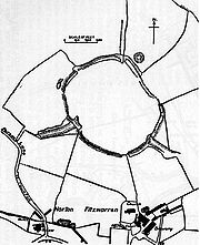 |
Norton Fitzwarren Norton Fitzwarren Norton Fitzwarren is a village and civil parish in Somerset, England, situated north west of Taunton in the Taunton Deane district. The village has a population of 2,325.-History:... 51.0304°N 3.1479°W |
The Norton Fitzwarren hill fort is part of the "Norton Hillfort Local Nature Reserve" and originally was occupied during the Stone Age Stone Age The Stone Age is a broad prehistoric period, lasting about 2.5 million years , during which humans and their predecessor species in the genus Homo, as well as the earlier partly contemporary genera Australopithecus and Paranthropus, widely used exclusively stone as their hard material in the... and into the Bronze Age Bronze Age The Bronze Age is a period characterized by the use of copper and its alloy bronze as the chief hard materials in the manufacture of some implements and weapons. Chronologically, it stands between the Stone Age and Iron Age... . |
| Oldberry Castle Oldberry Castle Oldberry Castle is an Iron Age hill fort north west of Dulverton, Somerset, England. It lies approximately north-west from Dulverton, close to the Devon border. It has been designated as a Scheduled Ancient Monument.... Oldbury Castle |
36531 | Dulverton Dulverton Dulverton is a town and civil parish in the heart of West Somerset, England, near the border with Devon. The town has a population of 1,630. The parish includes the hamlets of Battleton and Ashwick which is located approximately north west of Dulverton... 51.0428°N 3.5572°W |
Oldberry Castle is an irregular oval shape measuring 220 metres (721.8 ft) by 91 metres (298.6 ft). It is defended by a bank measuring 3 metres (9.8 ft) wide and 1.8 metres (5.9 ft) high, and a 5.5 metres (18 ft) wide ditch. |
||
| Plainsfield Camp Plainsfield Camp Plainsfield Camp is a possible Iron Age earthwork on the Quantock Hills near Aisholt in Somerset, England.The so-called hill fort has several features that make it more likely to be an animal enclosure, than a defended settlement:... |
189501 | Aisholt 51.1192°N 3.1687°W |
Plainsfield Camp is a possible Iron Age univallate settlement that is shaped like a rhombus Rhombus In Euclidean geometry, a rhombus or rhomb is a convex quadrilateral whose four sides all have the same length. The rhombus is often called a diamond, after the diamonds suit in playing cards, or a lozenge, though the latter sometimes refers specifically to a rhombus with a 45° angle.Every... . It is around 540 feet (164.6 m) by 450 feet (137.2 m), enclosing an approximate area of 0.1 hectares (1,000 m²), with a single bank around 10 feet (3 m) high. |
||
| Road Castle Road Castle Road Castle is an Iron Age bank and ditch in the West Somerset district of Somerset, England. The hill fort is situated approximately west from the village of Winsford. The ditch is almost square in plan with rounded corners and covers an area of approximately .-Background:Hill forts developed in... |
Iron Age Iron Age The Iron Age is the archaeological period generally occurring after the Bronze Age, marked by the prevalent use of iron. The early period of the age is characterized by the widespread use of iron or steel. The adoption of such material coincided with other changes in society, including differing... |
35715 | Winsford, Somerset Winsford, Somerset Winsford is a village and civil parish in Somerset, England, located about north-west of Dulverton.It is within the borders of the Exmoor National Park and around south-west of the coastal town of Minehead. The village has two hotels, Karslake House Hotel and the Royal Oak, both dating to before... 51.1261°N 3.6264°W |
It is likely that the bank and ditch defined enclosure at this site is of Iron Age date. |
|
| Roddenbury hill fort Roddenbury Hillfort Roddenbury Hillfort is a univallate Iron Age hillfort in the parish of Selwood, Somerset, England. It is a Scheduled Ancient Monument and on the Heritage at Risk register. It is close to the later Hales Castle.The site covers... |
202867 | Selwood Selwood, Somerset Selwood used to be a village but is now part of the suburbs of Frome. It is a civil parish in the Mendip district of Somerset, England. The parish includes the villages of East and West Woodlands, Rodden and the hamlet of Alder Row.-History:... 51.1944°N 2.2897°W |
Roddenbury hill fort is a large, univallate hill fort enclosing 0.84 hectares (2.1 acre). |
||
| Rodhuish Common Rodhuish Common Rodhuish Common is a univallate Iron Age hill fort in the West Somerset district of Somerset, England. There is a small oval enclosure which is thought to be of Iron Age date.-Background:... |
Iron Age Iron Age The Iron Age is the archaeological period generally occurring after the Bronze Age, marked by the prevalent use of iron. The early period of the age is characterized by the widespread use of iron or steel. The adoption of such material coincided with other changes in society, including differing... |
1139717 | Withycombe Withycombe Withycombe is a village and civil parish south east of Dunster, and from Minehead within the Exmoor National Park in the West Somerset district of Somerset, England... 51.1435°N 3.4323°W |
On Rodhuish Common is a small oval enclosure which is thought to be of Iron Age date. |
|
| Ruborough Camp Ruborough Camp Ruborough Camp is an Iron Age hill fort on the Quantock Hills near Broomfield in Somerset, England. The name comes from Rugan beorh or Ruwan-beorge meaning Rough Hill. It is a Scheduled Ancient Monument.-Background:... Rowberrow Rowborough Roborough Money Field |
191142 | 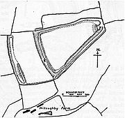 |
Broomfield Broomfield, Somerset Broomfield is a village and civil parish in the Sedgemoor district of Somerset, England, situated about five miles north of Taunton. According to the 2001 census it had a population of 224.... 51.0956°N 3.1038°W |
The Ruborough Camp hill fort is on an easterly spur from the main Quantock ridge, with steep natural slopes to the north and south-east. The fort is triangular in shape, with a single rampart and ditch (univallate), enclosing 1.8 hectares (4.4 acre). There is a linear outer work about 120 metres (393.7 ft) away, parallel to the westerly rampart, enclosing another 1.8 hectares (4.4 acre). There was a subterranean tunnel, which has now been filed in, which gave the camp safe access to a nearby spring for water. |
|
| Sigwells Sigwells Sigwells is hamlet located in an area rich in archaeology remains, overlooking Cadbury Castle in Somerset, England.It was the target of research by the South Cadbury Environs Project, which produced significant Early Bronze Age and Middle and Late Iron Age archaeology... |
Iron Age Iron Age The Iron Age is the archaeological period generally occurring after the Bronze Age, marked by the prevalent use of iron. The early period of the age is characterized by the widespread use of iron or steel. The adoption of such material coincided with other changes in society, including differing... |
199838 | – | Charlton Horethorne Charlton Horethorne Charlton Horethorne is a village and civil parish in Somerset, England, situated five miles north-east of Sherborne and five miles south-west of Wincanton in the South Somerset district... 51.012°N 2.507°W |
Sigwells Camp overlooks Cadbury Castle Cadbury Castle, Somerset Cadbury Castle is an Iron Age hill fort in the civil parish of South Cadbury in the English county of Somerset. It is a Scheduled Ancient Monument and associated with King Arthur.-Background:... . It was the target of research by the South Cadbury Environs Project, which produced significant Early Bronze Age and Middle and Late Iron Age archaeology. Of national importance was the identification of the earliest known metalworking Metalworking Metalworking is the process of working with metals to create individual parts, assemblies, or large scale structures. The term covers a wide range of work from large ships and bridges to precise engine parts and delicate jewelry. It therefore includes a correspondingly wide range of skills,... building in Britain, dated to Middle Bronze Age (12th century BC). |
| Small Down Knoll Small Down Knoll Small Down Knoll, or Small Down Camp, is a Bronze Age hill fort near Evercreech in Somerset, England. The hill is on the southern edge of the Mendip Hills, and rises to 222 m .Finds of flints indicate a prehistoric Mesolithic occupation.... Small Down Camp |
200348 | 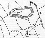 |
Evercreech Evercreech Evercreech is a village and civil parish south east of Shepton Mallet, and north east of Castle Cary, in the Mendip district of Somerset, England... 51.1646°N 2.4790°W |
Small Down Camp is a multivallate hill fort enclosing 2 hectares (4.9 acre). There is also a group of around 14 barrow Tumulus A tumulus is a mound of earth and stones raised over a grave or graves. Tumuli are also known as barrows, burial mounds, Hügelgrab or kurgans, and can be found throughout much of the world. A tumulus composed largely or entirely of stones is usually referred to as a cairn... s within the walls of the camp. Multiple walls and a ditch defend the site, but the walls are crumbling and the ditch has been filled up. |
|
| Solsbury Hill Solsbury Hill Little Solsbury Hill is a small flat-topped hill and the site of an Iron Age hill fort. It is located above the village of Batheaston in Somerset, England. The hill rises to above the River Avon which is just over to the south. It is within the Cotswolds Area of Outstanding Natural Beauty... Little Solsbury Hill |
203323 | Batheaston Batheaston Batheaston is a village and civil parish east of Bath, England , on the north bank of the River Avon. The parish has a population of 2,625... 51.4100°N 2.3342°W |
Occupied between 300 BC and 100 BC, comprising a triangular area enclosed by a single univallate rampart, faced inside and out with well-built dry stone walls and infilled with rubble. The rampart was 6 metres (20 ft) wide and the outer face was at least 4 metres (13 ft) high. The top of the hill was cleared down to the bedrock, then substantial huts were built with wattle and daub Wattle and daub Wattle and daub is a composite building material used for making walls, in which a woven lattice of wooden strips called wattle is daubed with a sticky material usually made of some combination of wet soil, clay, sand, animal dung and straw... on a timber-frame. After a period of occupation, some of the huts were burnt down, the rampart was overthrown, and the site was abandoned, never to be reoccupied. This event is probably part of the Belgic invasion of Britain in the early part of the 1st century BC. |
||
| Stantonbury Camp Stantonbury Camp Stantonbury Camp is the site of an Iron Age hillfort near Stanton Prior within the parish of Marksbury in Somerset, England. It is a Scheduled Ancient Monument.-Background:... |
201138 | Marksbury Marksbury Marksbury is a small village and civil parish in Somerset about from Keynsham and from Bath on the A39 where it meets the A368. The parish, which includes the villages of Hunstrete and Stanton Prior, has a population of 399.- History :... 51.3719°N 2.4718°W |
Stantonbury Camp is an Iron Age hill fort close to Wansdyke Wansdyke (earthwork) Wansdyke is a series of early medieval defensive linear earthworks in the West Country of England, consisting of a ditch and a running embankment from the ditch spoil, with the ditching facing north. It runs at least from Maes Knoll in historic Somerset, a hillfort at the east end of Dundry Hill... . On the English Heritage English Heritage English Heritage . is an executive non-departmental public body of the British Government sponsored by the Department for Culture, Media and Sport... Heritage at Risk Register. |
||
| Stokeleigh Camp Stokeleigh Camp Stokeleigh Camp is an Iron Age promontory hillfort in Leigh Woods North Somerset near Bristol, England. It has been designated a Scheduled Ancient Monument.-Background:... |
198375 | – | Leigh Woods Leigh Woods Leigh Woods is a 2 square kilometre area of woodland on the south-west side of the Avon Gorge, opposite the English city of Bristol and north of the Ashton Court estate. It has been designated as a National Nature Reserve. Small mountain biking circuits are present in the woods and the area is a... 51.4570°N 2.6361°W |
Evidence shows that Stokeleigh Camp in Leigh Woods Leigh Woods Leigh Woods is a 2 square kilometre area of woodland on the south-west side of the Avon Gorge, opposite the English city of Bristol and north of the Ashton Court estate. It has been designated as a National Nature Reserve. Small mountain biking circuits are present in the woods and the area is a... was a key site in the defence of the Avon Gorge Avon Gorge The Avon Gorge is a 1.5-mile long gorge on the River Avon in Bristol, England. The gorge runs south to north through a limestone ridge west of Bristol city centre, and about 3 miles from the mouth of the river at Avonmouth. The gorge forms the boundary between the unitary authorities of... . It is situated on a promontory. |
|
| Sweetworthy Sweetworthy Sweetworthy is an Iron Age hill fort or enclosure at Luccombe, south of Porlock, Somerset, England. It is on the north-facing slope of Dunkery Hill. It has a single rampart and external ditch, enclosing . The rampart is still visible and the ditch on the east side is used as a trackway... |
35980 | – | Luccombe Luccombe, Somerset Luccombe is a village and civil parish in the Exmoor National Park in the English county of Somerset. It at the foot of the moor's highest hill, the Dunkery Beacon, and is about one mile south of the A39 road between Porlock and Minehead. Administratively it forms part of the district of West... 51.1709°N 3.5891°W |
Sweetworthy is an Iron Age hill fort or enclosure on the north-facing slope of Dunkery Hill Dunkery Beacon Dunkery Beacon is the summit of Dunkery Hill, and the highest point on Exmoor and in Somerset, England. It is also the highest point in southern England outside Dartmoor.... . It has a single rampart and external ditch, enclosing 0.25 hectare (0.61776290753819 acre). The rampart is still visible and the ditch on the east side is used as a trackway. |
|
| Taps Combe Camp Taps Combe Camp Taps Combe Camp is an Iron Age hill fort in the Mendip district of Somerset, England. The hill fort is situated approximately east from the village of Brockley... Chelvey Batch Settlement |
194826 | – | Chelvey 51.3996°N 2.7489°W |
Taps Combe Camp is a Roman Ancient Rome Ancient Rome was a thriving civilization that grew on the Italian Peninsula as early as the 8th century BC. Located along the Mediterranean Sea and centered on the city of Rome, it expanded to one of the largest empires in the ancient world.... , Iron Age univallate hill fort Hill fort A hill fort is a type of earthworks used as a fortified refuge or defended settlement, located to exploit a rise in elevation for defensive advantage. They are typically European and of the Bronze and Iron Ages. Some were used in the post-Roman period... in Chelvey, Somerset Somerset The ceremonial and non-metropolitan county of Somerset in South West England borders Bristol and Gloucestershire to the north, Wiltshire to the east, Dorset to the south-east, and Devon to the south-west. It is partly bounded to the north and west by the Bristol Channel and the estuary of the... . It is "D"-shaped, and is approximately 50 metres (164 ft) by 50 metres (164 ft). |
|
| Tedbury Camp Tedbury Camp Tedbury Camp is a multivallate Iron Age promontory hill fort defended by two parallel banks near Great Elm, Somerset, England.-Background:Hill forts developed in the Late Bronze and Early Iron Age, roughly the start of the first millennium BC. The reason for their emergence in Britain, and... |
202769 | Great Elm Great Elm Great Elm is a village and civil parish between Mells and Frome in the Mendip district of Somerset, England. The parish includes the hamlet of Hapsford.-History:... 51.2378°N 2.3681°W |
Tedbury Camp is a multivallate promontory hill fort defended by two parallel banks. The inner bank measuring 1.3 metres (4.3 ft) wide and standing 3 metres (9.8 ft) to 4.5 metres (14.8 ft) high. There may have been a third bank. Also the site of Roman occupation and a coin hoard. |
||
| Trendle Ring Trendle Ring Trendle Ring is an Iron Age earthwork on the Quantock Hills near Bicknoller in Somerset, England. It is a Scheduled Ancient Monument .The word trendle means circle, so it is a tautological place name.... |
189562 | 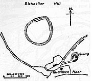 |
Bicknoller Bicknoller Bicknoller is a village and civil parish on the western slopes of the Quantock Hills in the English county of Somerset.Administratively, the civil parish falls within the West Somerset local government district within the Somerset shire county, with administrative tasks shared between county,... 51.1470°N 3.2623°W |
Trendle Ring is a univallate hill fort shaped like a rounded quadrilateral Quadrilateral In Euclidean plane geometry, a quadrilateral is a polygon with four sides and four vertices or corners. Sometimes, the term quadrangle is used, by analogy with triangle, and sometimes tetragon for consistency with pentagon , hexagon and so on... , enclosing around 0.7 hectares (1.7 acre). It is enclosed by a ring of stones up to around 1.5 metres (4.9 ft) high and still further by a ditch. |
|
| Tunley Camp Tunley Camp Tunley Camp is an univallate Iron Age hill fort situated approximately north-east from the small village of Camerton in the Bath and North East Somerset district of Somerset, England... |
200471 | – | Camerton Camerton, Somerset Camerton is a village and civil parish in Somerset, south west of Bath, lying on the Cam Brook. The parish has a population of 660.-History:... 51.3309°N 2.4561°W |
Tunley Camp comprises the slight earthwork remains of a univallate Iron Age hill fort, which is now nearly ploughed down. |
|
| Wadbury Camp | Iron Age Iron Age The Iron Age is the archaeological period generally occurring after the Bronze Age, marked by the prevalent use of iron. The early period of the age is characterized by the widespread use of iron or steel. The adoption of such material coincided with other changes in society, including differing... |
Mells Mells, Somerset Mells is a village and civil parish in Somerset, England, near the town of Frome.The parish includes the village of Vobster which had a coal mine of the same name on the Somerset coalfield and quarry, both of which are now disused. The old quarry is now used as a diving centre... 51.2391°N 2.3803°W |
A promontory fort or univallate hillfort with earthwork remains. The bank in places is up to 16 feet (4.9 m) high. Other parts have been almost completely destroyed. |
||
| Wain's Hill Wain's Hill Wain's Hill is an univallate Iron Age hill fort situated approximately south-west from the town of Clevedon in the North Somerset district of Somerset, England... |
192815 | – | Clevedon 51.4317°N 2.8781°W |
Wain's Hill is an Iron Age promontory bivallate hill fort visible as linear earthwork banks and ditches. It lies on a triangular spit of land on Wain's Hill in west Clevedon, and the hill fort is defined by steep natural slopes to the south, north, and west, and by two ramparts to the east. |
|
| Walton Banjo | Iron Age Iron Age The Iron Age is the archaeological period generally occurring after the Bronze Age, marked by the prevalent use of iron. The early period of the age is characterized by the widespread use of iron or steel. The adoption of such material coincided with other changes in society, including differing... |
195425 | Walton in Gordano Walton in Gordano Walton in Gordano is a village and civil parish in North Somerset, England. It is situated in a small valley at the side of the south-western end of the Gordano Valley, about a mile from Clevedon... 51.4597°N 2.8240°W |
A banjo enclosure believed to date from the late Iron Age. |
|
| Westbury Camp Westbury Camp Westbury Camp is a univallate Iron Age hill fort in the Sedgemoor district of Somerset, England. The hill fort is situated approximately north-east from the village of Draycott. The camp is largely situated in a hill slope. The north east defences has largely been destroyed by small quarries over... |
194654 | – | Rodney Stoke Rodney Stoke Rodney Stoke is a small village and civil parish, located at , 5 miles north-west of Wells, in the English county of Somerset. The village is on the A371 between Draycott and Westbury-sub-Mendip.... 51.2570°N 2.7294°W |
Westbury Camp is a large, irregularly-shaped hill fort surrounded by a bank and ditch covering approximately 2.3 hectares (5.7 acre). |
|
| Worlebury Camp Worlebury Camp Worlebury Camp is the name of the place where an Iron Age hill fort once stood atop Worlebury Hill, which is north of the town of Weston-super-Mare in Somerset, England. This fort was designed for defence, as is evidenced the number of walls and ditches around the site. Archaeologists have found... |
192721 | Worlebury Hill Worlebury Hill Worlebury Hill is the name given to an upland area lying between the flatlands of Weston-super-Mare and the Kewstoke area of North Somerset, England. Worlebury Hill's rises from sea level to its highest point of , and the western end of the hill forms a peninsula, jutting out into the Bristol... 51.3574°N 2.9852°W |
Worlebury Camp is an Iron Age hill fort that was designed for defence, as is evidenced by the number of walls and ditches around the site. Archaeologists have found several large triangular platforms around the sides of the fort, lower down on the hillside. They have found nearly one hundred storage pits of various sizes cut into the bedrock Bedrock In stratigraphy, bedrock is the native consolidated rock underlying the surface of a terrestrial planet, usually the Earth. Above the bedrock is usually an area of broken and weathered unconsolidated rock in the basal subsoil... , and many of these had human remains, coins, and other artefacts in them. However, in more recent times, the fort has suffered damage and been threatened with complete destruction on multiple occasions. |
||
| Wraxall Camp | Iron Age Iron Age The Iron Age is the archaeological period generally occurring after the Bronze Age, marked by the prevalent use of iron. The early period of the age is characterized by the widespread use of iron or steel. The adoption of such material coincided with other changes in society, including differing... |
198555 | Failand Failand Failand is a village in Somerset, England. It lies within the civil parish of Wraxall and Failand and the unitary authority area of North Somerset.... 51.4444°N 2.6913°W |
This site, situated on level ground within an upland area of carboniferous limestone was an Iron Age defended settlement. |
Suspected hill forts and settlements
| Site Name Alternative name(s) |
Age | Scheduling Number Scheduled Ancient Monument In the United Kingdom, a scheduled monument is a 'nationally important' archaeological site or historic building, given protection against unauthorized change. The various pieces of legislation used for legally protecting heritage assets from damage and destruction are grouped under the term... |
Plan | Location | Description |
|---|---|---|---|---|---|
| Berwick | 204546 | – | Bath 51.3615°N 2.3742°W |
Berwick is a possible multivallate Iron Age hill fort that has since been destroyed. A "camp" called Berwick, Berewyke, or Berewyck, adjoining Cottage Crescent and near Barrack Farm, was described in the early 19th century. |
|
| Charterhouse Camp Charterhouse Camp Charterhouse Camp is a univallate Iron Age hill fort in the Mendip district of Somerset, England. The hill fort is situated approximately east from the village of Charterhouse... |
Bronze Age Bronze Age The Bronze Age is a period characterized by the use of copper and its alloy bronze as the chief hard materials in the manufacture of some implements and weapons. Chronologically, it stands between the Stone Age and Iron Age... |
Charterhouse Charterhouse, Somerset Charterhouse, also known as Charterhouse-on-Mendip, is a hamlet in the Mendip Hills Area of Outstanding Natural Beauty in the English county of Somerset... 51.2986°N 2.7221°W |
There is evidence, in the form of burials in local caves, of human occupation since the late Neolithic Neolithic The Neolithic Age, Era, or Period, or New Stone Age, was a period in the development of human technology, beginning about 9500 BC in some parts of the Middle East, and later in other parts of the world. It is traditionally considered as the last part of the Stone Age... /Early Bronze Age Bronze Age The Bronze Age is a period characterized by the use of copper and its alloy bronze as the chief hard materials in the manufacture of some implements and weapons. Chronologically, it stands between the Stone Age and Iron Age... . |
||
| Daw's Castle Daw's Castle Daw's Castle is a sea cliff hill fort just west of Watchet, a harbour town in Somerset, England. It is a Scheduled Ancient Monument.The name comes from Thomas Dawe, who owned castell field in 1537.... |
188490 | 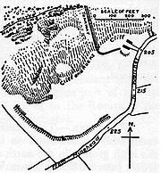 |
Watchet Watchet Watchet is a harbour town and civil parish in the English county of Somerset, with an approximate population of 4,400. It is situated west of Bridgwater, north-west of Taunton, and east of Minehead. The parish includes the hamlet of Beggearn Huish... 51.1810°N 3.3430°W |
The Daw's Castle hill fort is situated on an east-west cliff about 80 m above the sea, on a tapering spur of land bounded by the Washford River to the south, as it flows to the sea at Watchet, about 1 kilometre (0.621372736649807 mi) east. The ramparts of the fort would have formed a semicircle backing on to the sheer cliffs, but coastal erosion has reduced the size of the enclosure, and later destruction by farming, limekilns, and the B3191 road, have left only about 300 m of ramparts visible today. The fort may be of Iron Age origin, but was (re)built and fortified as a burh Burh A Burh is an Old English name for a fortified town or other defended site, sometimes centred upon a hill fort though always intended as a place of permanent settlement, its origin was in military defence; "it represented only a stage, though a vitally important one, in the evolution of the... by King Alfred, as part of his defense against Viking Viking The term Viking is customarily used to refer to the Norse explorers, warriors, merchants, and pirates who raided, traded, explored and settled in wide areas of Europe, Asia and the North Atlantic islands from the late 8th to the mid-11th century.These Norsemen used their famed longships to... raids from the Bristol Channel Bristol Channel The Bristol Channel is a major inlet in the island of Great Britain, separating South Wales from Devon and Somerset in South West England. It extends from the lower estuary of the River Severn to the North Atlantic Ocean... around 878 AD Anno Domini and Before Christ are designations used to label or number years used with the Julian and Gregorian calendars.... . |