
Meare Pool
Encyclopedia
Meare Pool was a lake in the Somerset Levels
in South West England
.
Meare Pool was formed by water ponding-up behind the raised peat bogs between the Wedmore and the Polden Hills
, and coring has shown that it is filled with at least 2 metres (6.6 ft) of detritus mud, especially in the Subatlantic climatic period (1st millennium BC
).
In prehistoric times there were two Meare Lake Village
s situated within the lake, occupied at different times between 300 BCE and 100 CE, similar to the nearby Glastonbury Lake Village
. The Meare villages were discovered in 1895 but excavation did not start until 1908. More recent studies have shown that the villages were formed by laying dried clay over the Sphagnum Moss
of the bog. The pool at that time was at least 2 miles (3.2 km) long by 1 miles (1.6 km) wide.
Early drainage work was carried out in the later years of the 12th century, with the responsibility for maintaining all the watercourses between Glastonbury and the sea being placed on named individuals among whom were Ralph de Sancta Barbara of Brentmarsh. Drainage of the surrounding area by monks of Glastonbury Abbey
had reduced the size of the lake to 500 acres (202.3 ha) at the time of the Dissolution of the Monasteries
. Meare Pool had disappeared from maps by 1749.
In World War II
a pillbox was located at Meare Pool at the confluence of the Decoy Rhyne and Whitelake River
.
. Its precise boundaries varied according to season, and, over the longer term, as efforts were made to drain the area. The south end was bordered by the high ground that the village of Meare is built upon. The pond would have extended no further west than the current Westhay
to Wedmore
road, where a shelf of rock formed a natural boundary. To the north lies the Godney
ridge. The eastern extent is harder to determine, and it may have gone as far as the site of the Glastonbury Lake Village.
Current Ordnance Survey
maps show Meare Pool as a placename in an area with spot heights of 4m.
 In the Domesday book
of 1086 the village of Meare is recorded as supporting "10 fishermen and 3 fisheries paying 20 pence". At the time of the Dissolution in 1540, Meare Pool was said to contain a great abundance of pike
, tench
, roach and eel
s. In 1638 it was owned by William Freake, who described it as "lately a fish pool".
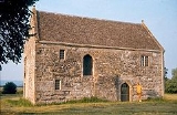
In the 14th century a Fish House
was built at Meare for the chief fisherman of the Abbot of Glastonbury that was also used for salting and preparing fish. It is the only surviving monastic fishery building in England. The importance of this industry is illustrated by a series of acrimonious disputes between Glastonbury and the Dean and Chapter of Wells Cathedral
. The Abbey required fish on Fridays, fast days and during Lent. As many as 5000 eels were landed in a typical year.
There were also three fishponds which would have allowed fish to have been bred or stored.
and Sheppey
, and discharged in a northerly direction into the Lower River Axe. In the later years of the 12th century the Abbey diverted the Brue to flow westwards, perhaps largely through natural channels, from Meare Pool to join the river Parrett. Further reclamation was carried out in stages between about 1620 and 1740, with the "new Cutts" (or Decoy Rhyne) being built about 1660. The rivers Sheppey
and Hartlake were canalised into the River James Wear and Division Rhyne sometime in the late 1730s.
Somerset Levels
The Somerset Levels, or the Somerset Levels and Moors as they are less commonly but more correctly known, is a sparsely populated coastal plain and wetland area of central Somerset, South West England, between the Quantock and Mendip Hills...
in South West England
South West England
South West England is one of the regions of England defined by the Government of the United Kingdom for statistical and other purposes. It is the largest such region in area, covering and comprising Bristol, Gloucestershire, Somerset, Dorset, Wiltshire, Devon, Cornwall and the Isles of Scilly. ...
.
Meare Pool was formed by water ponding-up behind the raised peat bogs between the Wedmore and the Polden Hills
Polden Hills
The Polden Hills in Somerset, England are a long, low ridge, extending for , and separated from the Mendip Hills, to which they are nearly parallel, by a marshy tract, known as the Somerset Levels...
, and coring has shown that it is filled with at least 2 metres (6.6 ft) of detritus mud, especially in the Subatlantic climatic period (1st millennium BC
1st millennium BC
The 1st millennium BC encompasses the Iron Age and sees the rise of many successive empires, and spanned from 1000 BC to 1 BC.The Neo-Assyrian Empire, followed by the Achaemenids. In Greece, Classical Antiquity begins with the colonization of Magna Graecia and peaks with the rise of Hellenism. The...
).
In prehistoric times there were two Meare Lake Village
Meare Lake Village
Meare Lake Village is the site of an Iron Age settlement on the Somerset Levels at Meare, Somerset, England. It is a Scheduled Ancient Monument.-Description:...
s situated within the lake, occupied at different times between 300 BCE and 100 CE, similar to the nearby Glastonbury Lake Village
Glastonbury Lake Village
Glastonbury Lake Village was an iron age village on the Somerset Levels near Godney, some north west of Glastonbury, Somerset, England. It has been designated as a Scheduled Ancient Monument and covers an area of north to south by east to west....
. The Meare villages were discovered in 1895 but excavation did not start until 1908. More recent studies have shown that the villages were formed by laying dried clay over the Sphagnum Moss
Sphagnum
Sphagnum is a genus of between 151 and 350 species of mosses commonly called peat moss, due to its prevalence in peat bogs and mires. A distinction is made between sphagnum moss, the live moss growing on top of a peat bog on one hand, and sphagnum peat moss or sphagnum peat on the other, the...
of the bog. The pool at that time was at least 2 miles (3.2 km) long by 1 miles (1.6 km) wide.
Early drainage work was carried out in the later years of the 12th century, with the responsibility for maintaining all the watercourses between Glastonbury and the sea being placed on named individuals among whom were Ralph de Sancta Barbara of Brentmarsh. Drainage of the surrounding area by monks of Glastonbury Abbey
Glastonbury Abbey
Glastonbury Abbey was a monastery in Glastonbury, Somerset, England. The ruins are now a grade I listed building, and a Scheduled Ancient Monument and are open as a visitor attraction....
had reduced the size of the lake to 500 acres (202.3 ha) at the time of the Dissolution of the Monasteries
Dissolution of the Monasteries
The Dissolution of the Monasteries, sometimes referred to as the Suppression of the Monasteries, was the set of administrative and legal processes between 1536 and 1541 by which Henry VIII disbanded monasteries, priories, convents and friaries in England, Wales and Ireland; appropriated their...
. Meare Pool had disappeared from maps by 1749.
In World War II
World War II
World War II, or the Second World War , was a global conflict lasting from 1939 to 1945, involving most of the world's nations—including all of the great powers—eventually forming two opposing military alliances: the Allies and the Axis...
a pillbox was located at Meare Pool at the confluence of the Decoy Rhyne and Whitelake River
Whitelake River
The Whitelake River is a small river on the Somerset Levels, England.The river rises between two low limestone ridges, part of the southern edge of the Mendip Hills. The confluence of the two small streams that make the Whitelake River is on Worthy Farm which is the site of the Glastonbury Festival...
.
Location
Meare Pool was located on low-lying levels just north of MeareMeare
Meare is a village and civil parish north west of Glastonbury on the Somerset Levels, in the Mendip district of Somerset, England. The parish includes the village of Westhay.-History:...
. Its precise boundaries varied according to season, and, over the longer term, as efforts were made to drain the area. The south end was bordered by the high ground that the village of Meare is built upon. The pond would have extended no further west than the current Westhay
Westhay
Westhay is a village in Somerset, England. It is situated in the parish of Meare, north west of Glastonbury on the Somerset Levels, in the Mendip district.The name means 'The west field that is enclosed by hedges' from the Old English west and haga...
to Wedmore
Wedmore
Wedmore is a village and civil parish in the county of Somerset, England. It is situated on raised ground, in the Somerset Levels between the River Axe and River Brue, often called the Isle of Wedmore. It forms part of Sedgemoor district...
road, where a shelf of rock formed a natural boundary. To the north lies the Godney
Godney
Godney is a village and civil parish near Glastonbury on the River Sheppey on the Somerset Levels in the Mendip district of Somerset, England.-Governance:...
ridge. The eastern extent is harder to determine, and it may have gone as far as the site of the Glastonbury Lake Village.
Current Ordnance Survey
Ordnance Survey
Ordnance Survey , an executive agency and non-ministerial government department of the Government of the United Kingdom, is the national mapping agency for Great Britain, producing maps of Great Britain , and one of the world's largest producers of maps.The name reflects its creation together with...
maps show Meare Pool as a placename in an area with spot heights of 4m.
Fishery
Domesday Book
Domesday Book , now held at The National Archives, Kew, Richmond upon Thames in South West London, is the record of the great survey of much of England and parts of Wales completed in 1086...
of 1086 the village of Meare is recorded as supporting "10 fishermen and 3 fisheries paying 20 pence". At the time of the Dissolution in 1540, Meare Pool was said to contain a great abundance of pike
Esox
Esox is a genus of freshwater fish, the only living genus in the family Esocidae — the esocids which were endemic to North America, Europe and Eurasia during the Paleogene through present.The type species is E. lucius, the northern pike...
, tench
Tench
The tench or doctor fish is a freshwater and brackish water fish of the cyprinid family found throughout Eurasia from Western Europe including the British Isles east into Asia as far as the Ob and Yenisei Rivers. It is also found in Lake Baikal...
, roach and eel
Eel
Eels are an order of fish, which consists of four suborders, 20 families, 111 genera and approximately 800 species. Most eels are predators...
s. In 1638 it was owned by William Freake, who described it as "lately a fish pool".
In the 14th century a Fish House
The Abbot's Fish House, Meare
The Abbot's Fish House in Meare, Somerset, England was built in the 14th century and has been designated as a Grade I listed building and Scheduled Ancient Monument.It was built between 1322 and 1335 when Adam of Sodbury was the abbot of Glastonbury Abbey...
was built at Meare for the chief fisherman of the Abbot of Glastonbury that was also used for salting and preparing fish. It is the only surviving monastic fishery building in England. The importance of this industry is illustrated by a series of acrimonious disputes between Glastonbury and the Dean and Chapter of Wells Cathedral
Wells Cathedral
Wells Cathedral is a Church of England cathedral in Wells, Somerset, England. It is the seat of the Bishop of Bath and Wells, who lives at the adjacent Bishop's Palace....
. The Abbey required fish on Fridays, fast days and during Lent. As many as 5000 eels were landed in a typical year.
There were also three fishponds which would have allowed fish to have been bred or stored.
Drainage
In early times the Meare Pool collected the waters of the rivers BrueRiver Brue
The River Brue originates in the parish of Brewham in Somerset, England, and reaches the sea some 50 km west at Burnham-on-Sea. It originally took a different route from Glastonbury to the sea, but this was changed by the monastery in the twelfth century....
and Sheppey
River Sheppey
The River Sheppey has its source in a group of springs west of the village of Doulting, near Shepton Mallet in Somerset, England. It flows through the wetlands to the north of the Polden Hills and ultimately joins the River Brue.- Route :...
, and discharged in a northerly direction into the Lower River Axe. In the later years of the 12th century the Abbey diverted the Brue to flow westwards, perhaps largely through natural channels, from Meare Pool to join the river Parrett. Further reclamation was carried out in stages between about 1620 and 1740, with the "new Cutts" (or Decoy Rhyne) being built about 1660. The rivers Sheppey
River Sheppey
The River Sheppey has its source in a group of springs west of the village of Doulting, near Shepton Mallet in Somerset, England. It flows through the wetlands to the north of the Polden Hills and ultimately joins the River Brue.- Route :...
and Hartlake were canalised into the River James Wear and Division Rhyne sometime in the late 1730s.