

Athelney
Encyclopedia
Athelney is located between the villages of Burrowbridge
and East Lyng
in the Sedgemoor
district of Somerset
, England
. The area is known as the Isle of Athelney, because it was once a very low isolated island in the 'very great swampy and impassable marshes' of the Somerset Levels
. Much of the Levels are below sea level. They are now drained for agricultural use during the summer, but are regularly flooded in the winter.
Athelney is around 6 miles from North Petherton
, where the Alfred Jewel
(an Anglo-Saxon
ornament dating from the late 9th century) was discovered in 1693.
, from where he went on to defeat the Danes
at the Battle of Eddington in May 878.
Archaeological
excavations and written evidence indicate that at the time of Alfred the island was linked by a causeway
to East Lyng
, with either end protected by a semi-circular stockade
and ditch. The ditch on the island is now known to date from the Iron Age
. It is therefore presumed that the Isle was known by Alfred to have been an ancient fort, and that its existing defences were strengthened by him. Evidence of metalworking
on the site suggests that he also used the island to equip his army.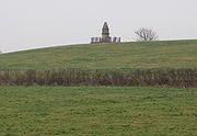 When translated from the Anglo-Saxon, the name of the isle, Æthelinga íeg, is often thought to mean the Island of Princes; if correct this might suggest that the island had royal connections prior to Alfred.
To give thanks for his victory, Alfred founded a monastery
, Athelney Abbey
, on the Isle in 888, which lasted until the Dissolution of the Monasteries
under Henry VIII
in 1539, when the value of the rubble was put at £80.
After Athelney Abbey was dissolved the monks then built the church in the neighbouring village of East Lyng
.
There are no remains of the monastery above ground, but excavations were carried out as part of the 1st and 100th Time Team
television archaeology programmes.
The monastery's location was marked by a small monument on top of the isle in 1801 built by Sir John Slade, 1st Baronet
of the Slade Baronets
, on the site of a stone vault. It is a Scheduled Ancient Monument
(Somerset County No 367) and Grade II listed building. The monument is now on private land belonging to Athelney Farm and, although visible from a layby off the A361, is not accessible to the public.
Burrowbridge
Burrowbridge is a village and civil parish in Somerset, England, situated on the River Parrett and A361 road south east of Bridgwater in the Taunton Deane district on the edge of the Somerset Levels...
and East Lyng
Lyng, Somerset
Lyng is a civil parish in Somerset, England, comprising the villages of West Lyng and East Lyng and the hamlet of Bankland.-History:The name derives from the Old English hlenc, meaning hill....
in the Sedgemoor
Sedgemoor
Sedgemoor is a low lying area of land in Somerset, England. It lies close to sea level south of the Polden Hills, historically largely marsh . The eastern part is known as King's Sedgemoor, and the western part West Sedgemoor. Sedgemoor is part of the area now known as the Somerset Levels...
district of Somerset
Somerset
The ceremonial and non-metropolitan county of Somerset in South West England borders Bristol and Gloucestershire to the north, Wiltshire to the east, Dorset to the south-east, and Devon to the south-west. It is partly bounded to the north and west by the Bristol Channel and the estuary of the...
, England
England
England is a country that is part of the United Kingdom. It shares land borders with Scotland to the north and Wales to the west; the Irish Sea is to the north west, the Celtic Sea to the south west, with the North Sea to the east and the English Channel to the south separating it from continental...
. The area is known as the Isle of Athelney, because it was once a very low isolated island in the 'very great swampy and impassable marshes' of the Somerset Levels
Somerset Levels
The Somerset Levels, or the Somerset Levels and Moors as they are less commonly but more correctly known, is a sparsely populated coastal plain and wetland area of central Somerset, South West England, between the Quantock and Mendip Hills...
. Much of the Levels are below sea level. They are now drained for agricultural use during the summer, but are regularly flooded in the winter.
Athelney is around 6 miles from North Petherton
North Petherton
North Petherton is a small town and civil parish in Somerset, England, situated on the edge of the eastern foothills of the Quantocks, and close to the edge of the Somerset Levels.The town has a population of 5,189...
, where the Alfred Jewel
Alfred Jewel
The Alfred Jewel is an Anglo-Saxon ornament dating from the late 9th century, discovered in 1693.It was made in the reign of King Alfred the Great and is inscribed "AELFRED MEC HEHT GEWYRCAN", meaning "Alfred ordered me made"...
(an Anglo-Saxon
Anglo-Saxons
Anglo-Saxon is a term used by historians to designate the Germanic tribes who invaded and settled the south and east of Great Britain beginning in the early 5th century AD, and the period from their creation of the English nation to the Norman conquest. The Anglo-Saxon Era denotes the period of...
ornament dating from the late 9th century) was discovered in 1693.
Isle of Athelney
The Isle of Athelney is best known for once being the fortress hiding place of King Alfred the GreatAlfred the Great
Alfred the Great was King of Wessex from 871 to 899.Alfred is noted for his defence of the Anglo-Saxon kingdoms of southern England against the Vikings, becoming the only English monarch still to be accorded the epithet "the Great". Alfred was the first King of the West Saxons to style himself...
, from where he went on to defeat the Danes
Viking
The term Viking is customarily used to refer to the Norse explorers, warriors, merchants, and pirates who raided, traded, explored and settled in wide areas of Europe, Asia and the North Atlantic islands from the late 8th to the mid-11th century.These Norsemen used their famed longships to...
at the Battle of Eddington in May 878.
Archaeological
Archaeology
Archaeology, or archeology , is the study of human society, primarily through the recovery and analysis of the material culture and environmental data that they have left behind, which includes artifacts, architecture, biofacts and cultural landscapes...
excavations and written evidence indicate that at the time of Alfred the island was linked by a causeway
Causeway
In modern usage, a causeway is a road or railway elevated, usually across a broad body of water or wetland.- Etymology :When first used, the word appeared in a form such as “causey way” making clear its derivation from the earlier form “causey”. This word seems to have come from the same source by...
to East Lyng
Lyng, Somerset
Lyng is a civil parish in Somerset, England, comprising the villages of West Lyng and East Lyng and the hamlet of Bankland.-History:The name derives from the Old English hlenc, meaning hill....
, with either end protected by a semi-circular stockade
Stockade
A stockade is an enclosure of palisades and tall walls made of logs placed side by side vertically with the tops sharpened to provide security.-Stockade as a security fence:...
and ditch. The ditch on the island is now known to date from the Iron Age
Iron Age
The Iron Age is the archaeological period generally occurring after the Bronze Age, marked by the prevalent use of iron. The early period of the age is characterized by the widespread use of iron or steel. The adoption of such material coincided with other changes in society, including differing...
. It is therefore presumed that the Isle was known by Alfred to have been an ancient fort, and that its existing defences were strengthened by him. Evidence of metalworking
Metalworking
Metalworking is the process of working with metals to create individual parts, assemblies, or large scale structures. The term covers a wide range of work from large ships and bridges to precise engine parts and delicate jewelry. It therefore includes a correspondingly wide range of skills,...
on the site suggests that he also used the island to equip his army.
To give thanks for his victory, Alfred founded a monastery
Monastery
Monastery denotes the building, or complex of buildings, that houses a room reserved for prayer as well as the domestic quarters and workplace of monastics, whether monks or nuns, and whether living in community or alone .Monasteries may vary greatly in size – a small dwelling accommodating only...
, Athelney Abbey
Athelney Abbey
Athelney Abbey, established in the county of Somerset, England, was founded by King Alfred in 888, as a religious house for monks of the Order of St. Benedict. It was dedicated to our Blessed Saviour, St. Peter, St. Paul, and St...
, on the Isle in 888, which lasted until the Dissolution of the Monasteries
Dissolution of the Monasteries
The Dissolution of the Monasteries, sometimes referred to as the Suppression of the Monasteries, was the set of administrative and legal processes between 1536 and 1541 by which Henry VIII disbanded monasteries, priories, convents and friaries in England, Wales and Ireland; appropriated their...
under Henry VIII
Henry VIII of England
Henry VIII was King of England from 21 April 1509 until his death. He was Lord, and later King, of Ireland, as well as continuing the nominal claim by the English monarchs to the Kingdom of France...
in 1539, when the value of the rubble was put at £80.
After Athelney Abbey was dissolved the monks then built the church in the neighbouring village of East Lyng
Lyng, Somerset
Lyng is a civil parish in Somerset, England, comprising the villages of West Lyng and East Lyng and the hamlet of Bankland.-History:The name derives from the Old English hlenc, meaning hill....
.
There are no remains of the monastery above ground, but excavations were carried out as part of the 1st and 100th Time Team
Time Team
Time Team is a British television series which has been aired on Channel 4 since 1994. Created by television producer Tim Taylor and presented by actor Tony Robinson, each episode features a team of specialists carrying out an archaeological dig over a period of three days, with Robinson explaining...
television archaeology programmes.
The monastery's location was marked by a small monument on top of the isle in 1801 built by Sir John Slade, 1st Baronet
Sir John Slade, 1st Baronet
General Sir John "Black Jack" Slade, 1st Baronet, GCH served as a general officer in the British Army during the Peninsular War. He lacked talent as a combat leader. Though Slade was praised in official reports, Arthur Wellesley, 1st Duke of Wellington criticized his actions privately and finally...
of the Slade Baronets
Slade Baronets
The Slade Baronetcy, of Maunsel House in the County of Somerset, is a title in the Baronetage of the United Kingdom. It was created on 30 September 1831 for General John Slade, a Peninsular War veteran. The second Baronet was a distinguished lawyer...
, on the site of a stone vault. It is a Scheduled Ancient Monument
Scheduled Ancient Monument
In the United Kingdom, a scheduled monument is a 'nationally important' archaeological site or historic building, given protection against unauthorized change. The various pieces of legislation used for legally protecting heritage assets from damage and destruction are grouped under the term...
(Somerset County No 367) and Grade II listed building. The monument is now on private land belonging to Athelney Farm and, although visible from a layby off the A361, is not accessible to the public.
External links
- A History of the County of Somerset: Volume 2: (1911) at British History Online Athelney
- The Somerset Urban Archaeological Survey: Lyng and Athelney by Miranda Richardson