

Dowsborough
Encyclopedia
Dowsborough Camp is an Iron Age
hill fort
on the Quantock Hills
near Nether Stowey
in Somerset
, England. It has been designated as a Scheduled Ancient Monument
(No: 189456).
. The reason for their emergence in Britain, and their purpose, has been a subject of debate. It has been argued that they could have been military sites constructed in response to invasion from continental Europe, sites built by invaders, or a military reaction to social tensions caused by an increasing population and consequent pressure on agriculture. The dominant view since the 1960s has been that the increasing use of iron led to social changes in Britain. Deposits of iron ore were located in different places to the tin and copper ore necessary to make bronze, and as a result trading patterns shifted and the old elites lost their economic and social status. Power passed into the hands of a new group of people. Archaeologist Barry Cunliffe
believes that population increase still played a role and has stated "[the forts] provided defensive possibilities for the community at those times when the stress [of an increasing population] burst out into open warfare. But I wouldn't see them as having been built because there was a state of war. They would be functional as defensive strongholds when there were tensions and undoubtedly some of them were attacked and destroyed, but this was not the only, or even the most significant, factor in their construction".
, and east over the valley of the River Parrett
.
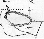
The fort has an oval shape, with a single rampart and ditch (univallate) following the contours of the hill top, enclosing an area of 2.7 ha
. The main entrance is to the east, towards Nether Stowey
, with a simpler opening to the north-west, aligned with a ridgeway leading down to Holford. The Lady's Fountain springs are in the combe
to the west. A col
to the south connects the hill to the main Stowey ridge, where a linear earthwork known as Dead Woman's Ditch cuts across the spur. This additional rampart would have provided an extra line of defence against attack from the main Quantock ridge to the west, and it could have been a tribal boundary.
, ran up from Combwich
, Cannington
(a possible site of the Battle of Cynwit) and Over Stowey
, along the present course of the Stowey road, across Dead Woman's Ditch to Crowcombe Park Gate, south along the main ridge of the Quantocks to Triscombe Stone, then west across the valley to the Brendon Hills
and Exmoor
. The road connected a series of forts and lookout posts, which allowed Alfred's armies to move along the coast to cover Viking
movements at sea and forestall any raids ashore. The path from Dowsborough to the Herepath is called Great Bear Path, and this is taken to be a corruption of Great Herepath, which suggests that Dowsborough could have been a Saxon lookout over the Bristol Channel
.
Iron Age
The Iron Age is the archaeological period generally occurring after the Bronze Age, marked by the prevalent use of iron. The early period of the age is characterized by the widespread use of iron or steel. The adoption of such material coincided with other changes in society, including differing...
hill fort
Hill fort
A hill fort is a type of earthworks used as a fortified refuge or defended settlement, located to exploit a rise in elevation for defensive advantage. They are typically European and of the Bronze and Iron Ages. Some were used in the post-Roman period...
on the Quantock Hills
Quantock Hills
The Quantock Hills is a range of hills west of Bridgwater in Somerset, England. The Quantock Hills were England’s first Area of Outstanding Natural Beauty being designated in 1956 and consists of large amounts of heathland, oak woodlands, ancient parklands and agricultural land.The hills run from...
near Nether Stowey
Nether Stowey
Nether Stowey is a large village in the Sedgemoor district of Somerset, South West England. It sits in the foothills of the Quantock Hills , just below Over Stowey...
in Somerset
Somerset
The ceremonial and non-metropolitan county of Somerset in South West England borders Bristol and Gloucestershire to the north, Wiltshire to the east, Dorset to the south-east, and Devon to the south-west. It is partly bounded to the north and west by the Bristol Channel and the estuary of the...
, England. It has been designated as a Scheduled Ancient Monument
Scheduled Ancient Monument
In the United Kingdom, a scheduled monument is a 'nationally important' archaeological site or historic building, given protection against unauthorized change. The various pieces of legislation used for legally protecting heritage assets from damage and destruction are grouped under the term...
(No: 189456).
Background
Hill forts developed in the Late Bronze and Early Iron Age, roughly the start of the first millennium BC1st millennium BC
The 1st millennium BC encompasses the Iron Age and sees the rise of many successive empires, and spanned from 1000 BC to 1 BC.The Neo-Assyrian Empire, followed by the Achaemenids. In Greece, Classical Antiquity begins with the colonization of Magna Graecia and peaks with the rise of Hellenism. The...
. The reason for their emergence in Britain, and their purpose, has been a subject of debate. It has been argued that they could have been military sites constructed in response to invasion from continental Europe, sites built by invaders, or a military reaction to social tensions caused by an increasing population and consequent pressure on agriculture. The dominant view since the 1960s has been that the increasing use of iron led to social changes in Britain. Deposits of iron ore were located in different places to the tin and copper ore necessary to make bronze, and as a result trading patterns shifted and the old elites lost their economic and social status. Power passed into the hands of a new group of people. Archaeologist Barry Cunliffe
Barry Cunliffe
Sir Barrington Windsor Cunliffe, CBE, known professionally as Barry Cunliffe is a former Professor of European Archaeology at the University of Oxford, a position held from 1972 to 2007...
believes that population increase still played a role and has stated "[the forts] provided defensive possibilities for the community at those times when the stress [of an increasing population] burst out into open warfare. But I wouldn't see them as having been built because there was a state of war. They would be functional as defensive strongholds when there were tensions and undoubtedly some of them were attacked and destroyed, but this was not the only, or even the most significant, factor in their construction".
Situation
The site is at a height of 340 m on an easterly spur from the main Quantock ridge, with views north to the Bristol ChannelBristol Channel
The Bristol Channel is a major inlet in the island of Great Britain, separating South Wales from Devon and Somerset in South West England. It extends from the lower estuary of the River Severn to the North Atlantic Ocean...
, and east over the valley of the River Parrett
River Parrett
The River Parrett flows through the counties of Dorset and Somerset in South West England, from its source in the Thorney Mills springs in the hills around Chedington in Dorset...
.
The fort has an oval shape, with a single rampart and ditch (univallate) following the contours of the hill top, enclosing an area of 2.7 ha
Hectare
The hectare is a metric unit of area defined as 10,000 square metres , and primarily used in the measurement of land. In 1795, when the metric system was introduced, the are was defined as being 100 square metres and the hectare was thus 100 ares or 1/100 km2...
. The main entrance is to the east, towards Nether Stowey
Nether Stowey
Nether Stowey is a large village in the Sedgemoor district of Somerset, South West England. It sits in the foothills of the Quantock Hills , just below Over Stowey...
, with a simpler opening to the north-west, aligned with a ridgeway leading down to Holford. The Lady's Fountain springs are in the combe
Valley
In geology, a valley or dale is a depression with predominant extent in one direction. A very deep river valley may be called a canyon or gorge.The terms U-shaped and V-shaped are descriptive terms of geography to characterize the form of valleys...
to the west. A col
Mountain pass
A mountain pass is a route through a mountain range or over a ridge. If following the lowest possible route, a pass is locally the highest point on that route...
to the south connects the hill to the main Stowey ridge, where a linear earthwork known as Dead Woman's Ditch cuts across the spur. This additional rampart would have provided an extra line of defence against attack from the main Quantock ridge to the west, and it could have been a tribal boundary.
Saxon era
In Saxon times, King Alfred's military road, the HerepathHerepath
A Herepath or Herewag is a military road in England, typically dating from the ninth century CE.This was a time of war between the Anglo-Saxon kingdoms of southern England and Viking invaders from Denmark...
, ran up from Combwich
Combwich
Combwich is a village in the parish of Otterhampton within the Sedgemoor district of Somerset, between Bridgwater and the Steart Peninsula.The village lies on Combwich Reach as the River Parrett flows to the sea and was the site of an ancient ferry crossing. In the Domesday book it was known as...
, Cannington
Cannington, Somerset
Cannington is a village and civil parish north-west of Bridgwater in the Sedgemoor district of Somerset, England. It lies on the west bank of the River Parret, and contains the hamlet of Edstock.-History:...
(a possible site of the Battle of Cynwit) and Over Stowey
Over Stowey
Over Stowey is a small village and civil parish in the Sedgemoor district of Somerset, South West England. It sits in the foothills of the Quantock Hills, just below Nether Stowey and north-west of Bridgwater...
, along the present course of the Stowey road, across Dead Woman's Ditch to Crowcombe Park Gate, south along the main ridge of the Quantocks to Triscombe Stone, then west across the valley to the Brendon Hills
Brendon Hills
The Brendon Hills are composed of a lofty ridge of hills in the East Lyn Valley area of western Somerset, England. The terrain is broken by a series of deeply incised streams and rivers running roughly southwards to meet the River Haddeo, a tributary of the River Exe.The hills are quite heavily...
and Exmoor
Exmoor
Exmoor is an area of hilly open moorland in west Somerset and north Devon in South West England, named after the main river that flows out of the district, the River Exe. The moor has given its name to a National Park, which includes the Brendon Hills, the East Lyn Valley, the Vale of Porlock and ...
. The road connected a series of forts and lookout posts, which allowed Alfred's armies to move along the coast to cover Viking
Viking
The term Viking is customarily used to refer to the Norse explorers, warriors, merchants, and pirates who raided, traded, explored and settled in wide areas of Europe, Asia and the North Atlantic islands from the late 8th to the mid-11th century.These Norsemen used their famed longships to...
movements at sea and forestall any raids ashore. The path from Dowsborough to the Herepath is called Great Bear Path, and this is taken to be a corruption of Great Herepath, which suggests that Dowsborough could have been a Saxon lookout over the Bristol Channel
Bristol Channel
The Bristol Channel is a major inlet in the island of Great Britain, separating South Wales from Devon and Somerset in South West England. It extends from the lower estuary of the River Severn to the North Atlantic Ocean...
.
See also
- Ruborough
- Trendle RingTrendle RingTrendle Ring is an Iron Age earthwork on the Quantock Hills near Bicknoller in Somerset, England. It is a Scheduled Ancient Monument .The word trendle means circle, so it is a tautological place name....
- Plainsfield CampPlainsfield CampPlainsfield Camp is a possible Iron Age earthwork on the Quantock Hills near Aisholt in Somerset, England.The so-called hill fort has several features that make it more likely to be an animal enclosure, than a defended settlement:...
- HerepathHerepathA Herepath or Herewag is a military road in England, typically dating from the ninth century CE.This was a time of war between the Anglo-Saxon kingdoms of southern England and Viking invaders from Denmark...
- List of hill forts and ancient settlements in Somerset