

List of North Carolina hurricanes (2000–present)
Encyclopedia
North Carolina
North Carolina is a state located in the southeastern United States. The state borders South Carolina and Georgia to the south, Tennessee to the west and Virginia to the north. North Carolina contains 100 counties. Its capital is Raleigh, and its largest city is Charlotte...
is a U.S. state located on the Atlantic Seaboard
Atlantic Seaboard
The Atlantic seaboard watershed is a watershed of North America along both*the Atlantic Canada coast south of the Gulf of Saint Lawrence Watershed &*the East Coast of the United States north of the watershed of the Okeechobee Waterway....
in the southeastern United States. Tropical cyclones—storm
Storm
A storm is any disturbed state of an astronomical body's atmosphere, especially affecting its surface, and strongly implying severe weather...
s characterized by a large low-pressure center and numerous thunderstorms that produce strong winds and heavy rain—regularly affect the state. According to statistical hurricane research between 1886 and 1996 by the North Carolina State Climatology Office, a tropical cyclone makes landfall
Landfall (meteorology)
Landfall is the event of a tropical cyclone or a waterspout coming onto land after being over water. When a waterspout makes landfall it is reclassified as a tornado, which can then cause damage inland...
along the coastline about once every four years. An estimated 17.5% of all Atlantic tropical cyclones
Atlantic hurricane
North Atlantic tropical cyclones usually form in the northern hemisphere summer or fall. Tropical cyclones can be categorized by intensity. Tropical storms have one-minute maximum sustained winds of at least 39 mph , while hurricanes have one-minute maximum sustained exceeding 74 mph...
have affected the state.
This list documents 48 tropical cyclones known to have affected the state between 2000 and the present. The most active month is September, with 20 total storms, while May and November are tied for the least active months with two storms each. While the most destructive and intense storm was Hurricane Isabel
Hurricane Isabel
Hurricane Isabel was the costliest and deadliest hurricane in the 2003 Atlantic hurricane season. The ninth named storm, fifth hurricane, and second major hurricane of the season, Isabel formed near the Cape Verde Islands from a tropical wave on September 6 in the tropical Atlantic Ocean...
in 2003, Tropical Storm Allison
Tropical Storm Allison
Tropical Storm Allison was a tropical storm that devastated southeast Texas in June of the 2001 Atlantic hurricane season. The first storm of the season, Allison lasted an unusually long period of time for a June storm, remaining tropical or subtropical for 15 days...
in 2001 caused the most fatalities. The first storm to impact the state during the period was Hurricane Florence
Hurricane Florence (2000)
Hurricane Florence was a Category 1 hurricane on the Saffir-Simpson Hurricane Scale that reached hurricane intensity three separate times. The tenth tropical cyclone and sixth named storm of the 2000 Atlantic hurricane season, Florence developed on September 20 from a cold front to the...
in September 2000, and the most recent was Hurricane Irene
Hurricane Irene (2011)
Hurricane Irene was a large and powerful Atlantic hurricane that left extensive flood and wind damage along its path through the Caribbean, the United States East Coast and as far north as Atlantic Canada in 2011...
in 2011. In terms of windspeeds, Hurricane Isabel
Hurricane Isabel
Hurricane Isabel was the costliest and deadliest hurricane in the 2003 Atlantic hurricane season. The ninth named storm, fifth hurricane, and second major hurricane of the season, Isabel formed near the Cape Verde Islands from a tropical wave on September 6 in the tropical Atlantic Ocean...
was the strongest storm to affect the state, producing maximum sustained winds equivalent to Category 2 status on the Saffir–Simpson Hurricane Scale.
2000–2002
- September 12, 2000 – Rip currents from Hurricane Florence kill three people due to drowning.
- September 19, 2000 – The extratropical remnants of Hurricane GordonHurricane Gordon (2000)Hurricane Gordon was one of two U.S. landfalling tropical storms of the 2000 Atlantic hurricane season, and was the 7th named storm and 4th hurricane of the 2000 Atlantic hurricane season. Gordon was a category 1 hurricane over the Gulf of Mexico but weakened to a tropical storm before making...
track through the state, dropping light to moderate rainfall. - September 23, 2000 – Tropical Depression HeleneTropical Storm Helene (2000)Tropical Storm Helene was a weak tropical cyclone that made landfall in the United States as a minimal tropical storm. The tropical system was the twelfth tropical cyclone and eighth tropical storm of the 2000 Atlantic hurricane season. After becoming a tropical depression east of the Windward...
re-intensifies into a tropical storm over the northeastern portion of the state, producing moderate rainfall across much of the state which peaks at 8.31 inches (211 mm) in Longwood. - June 13, 2001 – The remnants of Tropical Storm AllisonTropical Storm AllisonTropical Storm Allison was a tropical storm that devastated southeast Texas in June of the 2001 Atlantic hurricane season. The first storm of the season, Allison lasted an unusually long period of time for a June storm, remaining tropical or subtropical for 15 days...
enter the state as a subtropical depressionSubtropical cycloneA subtropical cyclone is a weather system that has some characteristics of a tropical and an extratropical cyclone. As early as the 1950s, meteorologists were unclear whether they should be characterized as tropical or extratropical cyclones. They were officially recognized by the National...
and drop over 10 inches (250 mm) of rainfall in the northeastern portion of the state; the rainfall results in nine indirect deaths due to traffic accidents on slick roads. - August 8, 2001 – The remnants of Tropical Storm BarryTropical Storm Barry (2001)Tropical Storm Barry was a strong tropical storm that made landfall on the Florida Panhandle during August 2001. The third tropical cyclone and second named storm of the 2001 Atlantic hurricane season, Barry developed from a tropical wave that moved off the coast of Africa on July 24 and tracked...
drop light rainfall in the state's mountainous region. - July 14, 2002 – Tropical Storm ArthurTropical Storm Arthur (2002)Tropical Storm Arthur was the first tropical cyclone of the 2002 Atlantic hurricane season. The origins of the storm are believed to have been from a decaying cold front in the Gulf of Mexico, which dropped light to moderate rainfall across the southeastern United States...
forms just offshore and drops light rainfall near the coast. - September 10, 2002 – Tropical Storm GustavHurricane Gustav (2002)Hurricane Gustav was a Category 2 hurricane that paralleled the East Coast of the United States in September during the 2002 Atlantic hurricane season. It was the seventh named storm and first hurricane of the season...
strikes the Outer Banks with a 5-foot (1.5 m) storm surge and hurricane force wind gusts, causing minor damage. - September 15, 2002 – The remnants of Tropical Storm HannaTropical Storm Hanna (2002)Tropical Storm Hanna was a moderately strong tropical storm that affected the Gulf Coast and Southeastern regions of the United States. The tenth tropical cyclone and ninth named storm of the 2002 Atlantic hurricane season, Hanna formed through the complex interaction of a surface trough, a...
drop moderate rainfall across much of the state, causing some flooding in Wilmington. - September 27, 2002 – The large wind field of what was once Hurricane IsidoreHurricane IsidoreHurricane Isidore was the ninth named storm and the second hurricane in the 2002 Atlantic hurricane season. Isidore was the fifth of eight named storms to occur in September. The tropical cyclone peaked as a Category 3 hurricane, causing damage as well as four fatalities in Jamaica, Cuba, Mexico,...
downs trees and power lines across the western portion of the state, which blocks numerous roads. - October 11, 2002 – Tropical Storm KyleHurricane Kyle (2002)Hurricane Kyle was the fourth longest-lived Atlantic tropical or subtropical cyclone on record. The eleventh named storm and third hurricane of the 2002 Atlantic hurricane season, Kyle developed as a subtropical cyclone on September 20 to the east-southeast of Bermuda. Looping westward, it...
makes landfall near Long BeachLong Beach, North CarolinaLong Beach, North Carolina is a coastal neighborhood that is incorporated into Oak Island, North Carolina in the year of 1955. Located on Oak Island, it is well known for the total devastation it sustained during Hurricane Hazel in 1954; only five of the 357 buildings survived the storm...
, spawning an F2Fujita scaleThe Fujita scale , or Fujita-Pearson scale, is a scale for rating tornado intensity, based primarily on the damage tornadoes inflict on human-built structures and vegetation...
tornado in PantegoPantego, North CarolinaPantego is a town in Beaufort County, North Carolina, United States. The population was 170 at the 2000 census.-Geography:Pantego is located at ....
and a few weaker tornadoes. The passage of the storm results in about a dozen damaged or destroyed houses, but no deaths or injuries in the state.
2003–2004
- July 2, 2003 – Tropical Depression BillTropical Storm Bill (2003)Tropical Storm Bill was a tropical storm that affected the Gulf Coast of the United States in the summer of 2003. The second storm of the 2003 Atlantic hurricane season, Bill developed from a tropical wave on June 29 to the north of the Yucatán Peninsula...
crosses the extreme western portion of the state. The storm drops locally heavy rainfall peaking at 9.7 inches (246 mm) in Transylvania CountyTransylvania County, North CarolinaTransylvania County is a county located in the U.S. state of North Carolina. As of 2010, the population was 33,090. Its county seat is Brevard.- History :The county was formed in 1861 from parts of Henderson County and Jackson County...
, with one fatality reported due to drowning. - July 26, 2003 – Tropical Depression SevenTropical Depression Seven (2003)Tropical Depression Seven of the 2003 Atlantic hurricane season was a weak tropical depression that formed off the northeast Florida coast. The seventh tropical cyclone of the season, the depression formed on July 25 from the same tropical wave that spawned previous Tropical Depression Six...
hits Georgia, dropping light rainfall in southern North Carolina. - September 2003 – The remnants of Tropical Storm GraceTropical Storm Grace (2003)Tropical Storm Grace was a weak tropical storm that struck Texas in the 2003 Atlantic hurricane season. The eleventh tropical depression and the seventh tropical storm of the season, Grace was also the weakest storm of the season. On August 30 the storm developed from a long-track tropical wave in...
produce light rainfall across much of the state. - September 4, 2003 – Rip currents from Hurricane FabianHurricane FabianHurricane Fabian was a powerful Cape Verde-type hurricane that hit Bermuda in early September during the 2003 Atlantic hurricane season. Fabian, the sixth named storm, fourth hurricane, and first major hurricane of the season, developed from a tropical wave in the tropical Atlantic Ocean on August 25...
cause one drowning death near Cape HatterasCape HatterasCape Hatteras is a cape on the coast of North Carolina. It is the point that protrudes the farthest to the southeast along the northeast-to-southwest line of the Atlantic coast of North America...
. - September 12, 2003 – The remnants of Tropical Storm HenriTropical Storm Henri (2003)Tropical Storm Henri was weak a tropical storm that formed in the 2003 Atlantic hurricane season. The eighth storm of the season, Henri was one of six tropical cyclones to hit the United States in the year. Henri formed from a tropical wave in the Gulf of Mexico in early September, and crossed over...
move across the eastern portion of the state, dropping light rainfall. - September 18, 2003 – Hurricane IsabelEffects of Hurricane Isabel in North CarolinaThe effects of Hurricane Isabel on North Carolina were the worst from a hurricane since Hurricane Floyd made landfall in 1999. Hurricane Isabel formed from a tropical wave on September 6, 2003 in the tropical Atlantic Ocean...
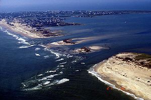
makes landfall at Drum InletDrum InletDrum Inlet is an inlet of the Outer Banks in the U.S. state of North Carolina. It connects the Core Sound with the Atlantic Ocean and separates North Core Banks from South Core Banks....
with winds of 105 mph (165 km/h) and causes three deaths in the state, one of which directly. Damage in the state totals $450 million, most of which in Dare CountyDare County, North Carolina-National protected areas:* Alligator River National Wildlife Refuge * Cape Hatteras National Seashore * Fort Raleigh National Historic Site* Pea Island National Wildlife Refuge* Wright Brothers National Memorial-Demographics:...
where thousands of homes are washed away. The storm surge produces a 2,000-foot (600 m) wide inletIsabel InletIsabel Inlet was an informally named inlet along the Outer Banks of North Carolina. It was created by Hurricane Isabel when it swept ashore on September 18, 2003....
on Hatteras IslandHatteras IslandHatteras Island is a barrier island located off the North Carolina coast. Dividing the Atlantic Ocean and the Pamlico Sound, it runs parallel to the coast, forming a bend at Cape Hatteras. It is part of North Carolina's Outer Banks and includes the towns of Rodanthe, Waves, Salvo, Avon, Buxton,...
, isolating HatterasHatteras, North CarolinaHatteras is an unincorporated community in Dare County, North Carolina, United States, on the Outer Banks island of Hatteras. North Carolina Highway 12 passes through the community linking it to Frisco and Ocracoke . It is south of the famous Cape Hatteras and the Cape Hatteras Lighthouse in Buxton...
by road for two months.
- August 3, 2004 – Hurricane AlexHurricane Alex (2004)Hurricane Alex was the first named storm, the first hurricane, and the first major hurricane of the 2004 Atlantic hurricane season. The first storm of the season, Alex formed unusually late in the season; the fifth latest since 1954. It developed from the interaction between an upper-level low and...
brushes the Outer Banks, producing strong waves and moderate storm surge flooding; one person is killed from the surf, and hundreds of vehicles and homes are flooded. - August 13, 2004 – The remnants of Tropical Storm BonnieTropical Storm Bonnie (2004)Tropical Storm Bonnie was a small tropical storm that made landfall on Florida in August 2004. The second storm of the 2004 Atlantic hurricane season, Bonnie developed from a tropical wave on August 3 to the east of the Lesser Antilles. After moving through the islands, its fast forward motion...
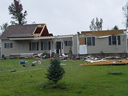
spawn an F2Fujita scaleThe Fujita scale , or Fujita-Pearson scale, is a scale for rating tornado intensity, based primarily on the damage tornadoes inflict on human-built structures and vegetation...
tornado near Rocky PointRocky Point, North CarolinaRocky Point is an unincorporated community in southern Pender County, North Carolina, United States. It is part of the Wilmington Metropolitan Statistical Area. Rocky Point is situated on North Carolina Highway 210 and North Carolina Highway 133 and U.S. Route 117, at an elevation of 39 feet ....
, killing three people; the tornado also destroys 17 houses and severely damages 27 buildings. - August 14, 2004 – Hurricane CharleyHurricane CharleyHurricane Charley was the third named storm, the second hurricane, and the second major hurricane of the 2004 Atlantic hurricane season. Charley lasted from August 9 to August 15, and at its peak intensity it attained 150 mph winds, making it a strong Category 4 hurricane on the...
moves ashore just southwest of the North Carolina – South Carolina border, resulting in moderate winds and about $25 million in damage as it tracks across the eastern portion of the state. - August 30, 2004 – Tropical Depression GastonHurricane Gaston (2004)Hurricane Gaston was a minimal hurricane that made landfall in South Carolina on August 29, 2004. It then crossed North Carolina and Virginia before exiting to the northeast and dissipating. The storm killed nine people — eight of them directly — and caused $130 million in damage....
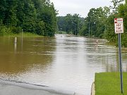
traverses the state, bringing moderate precipitation which causes some flooding. - September 8, 2004 – Former Hurricane FrancesHurricane FrancesHurricane Frances was the sixth named storm, the fourth hurricane, and the third major hurricane of the 2004 Atlantic hurricane season. The system crossing the open Atlantic during mid to late August, moving to the north of the Lesser Antilles while strengthening. Its outer bands affected Puerto...
crosses the western portion of the state, dropping very heavy rainfall peaking at 23.6 inches (599 mm) on Mount MitchellMount Mitchell (North Carolina)Mount Mitchell is the highest peak of the Appalachian Mountains and the highest peak in the eastern United States. It was the highest point in any state of the United States until Texas joined the union in 1845. The nearest higher point east of the Rocky Mountains is Harney Peak in the Black Hills...
. The rainfall causes widespread flooding, with many creeks and rivers surpassing flood stage; hundreds of homes and businesses are damaged or destroyed. - September 17, 2004 – Former Hurricane IvanHurricane IvanHurricane Ivan was a large, long-lived, Cape Verde-type hurricane that caused widespread damage in the Caribbean and United States. The cyclone was the ninth named storm, the sixth hurricane and the fourth major hurricane of the active 2004 Atlantic hurricane season...
tracks along the border between North Carolina and Tennessee, dropping heavy rainfall that peaks at 17.0 inches (432 mm) in Cruso, as well as producing 4 tornadoes in the state. The hurricane kills eight people in the state, and causes severe flooding just nine days after the previous cyclone tracked through the area; the flooding damage or destroy hundreds of buildings, and washes away several bridges. - September 25, 2004 – Heavy surf from Hurricane JeanneHurricane JeanneHurricane Jeanne was the deadliest hurricane in the 2004 Atlantic hurricane season. It was the tenth named storm, the seventh hurricane, and the fifth major hurricane of the season, as well as the third hurricane and fourth named storm of the season to make landfall in Florida...
kills a man to the east of Oak IslandOak Island (North Carolina)Oak Island is a barrier island on the Atlantic coast of southeastern North Carolina in Brunswick County. The island contains the towns of Oak Island and Caswell Beach as well as the North Carolina Baptist Assembly and a United States Coast Guard station, which is home to the Oak Island Lighthouse...
after he is thrown overboard from his boat. Three days later the storm's remnants cross the western portion of the state, causing the third flood in a month; the flood from Jeanne is less severe and shorter in duration than that from Ivan and Frances.
2005–2007

- June 12, 2005 – Tropical Depression ArleneTropical Storm Arlene (2005)Tropical Storm Arlene was an unusually large and early-forming tropical storm forming during the 2005 Atlantic hurricane season. It was the first storm of the season, which would become the most active on record. Tropical Storm Arlene formed near Honduras on June 8 and moved northwards...
passes west of the state, producing locally heavy rainfall peaking at 9.84 inches (250 mm) in Transylvania CountyTransylvania County, North CarolinaTransylvania County is a county located in the U.S. state of North Carolina. As of 2010, the population was 33,090. Its county seat is Brevard.- History :The county was formed in 1861 from parts of Henderson County and Jackson County...
. - July 7, 2005 – The remnants of Hurricane CindyHurricane Cindy (2005)Hurricane Cindy was a tropical cyclone that briefly reached minimal hurricane strength in the Gulf of Mexico during July in the 2005 Atlantic hurricane season and made landfall in Louisiana. It was the third named storm and first hurricane of the season...
spawn eight tornadoes in the state, including one near HarmonyHarmony, North CarolinaHarmony is a town in Iredell County, North Carolina, United States. The population was 533 at the 2010 census. The town is located in northeastern Iredell County and lies in the eastern portion of the North Carolina High Country.-Geography:...
that damages or destroys over a dozen structures. - July 11, 2005 – Tropical Depression DennisHurricane DennisHurricane Dennis was an early-forming major hurricane in the Caribbean and Gulf of Mexico during the very active 2005 Atlantic hurricane season. Dennis was the fourth named storm, second hurricane, and first major hurricane of the season...
passes through Tennessee, with its large circulation dropping moderate to heavy precipitation in western North Carolina. - August 30, 2005 – The remnants of Hurricane KatrinaHurricane KatrinaHurricane Katrina of the 2005 Atlantic hurricane season was a powerful Atlantic hurricane. It is the costliest natural disaster, as well as one of the five deadliest hurricanes, in the history of the United States. Among recorded Atlantic hurricanes, it was the sixth strongest overall...
produce moderate rainfall and gusty winds in the western portion of the state. - September 14 – September 16, 2005 – Hurricane OpheliaHurricane Ophelia (2005)Hurricane Ophelia was the fifteenth named tropical cyclone and the eighth hurricane of the 2005 Atlantic hurricane season. It was a long-lived storm that was most remembered for its very erratic and extremely slow track off the East Coast of the United States, alternating several times between...
drifts just offshore of the Outer Banks, dropping heavy rainfall peaking at 17.5 inches (445 mm) and causing $70 million in damage. - October 7, 2005 – Tropical Storm TammyTropical Storm Tammy (2005)Tropical Storm Tammy was a short lived tropical storm during October in the 2005 Atlantic hurricane season which caused minor damage to the southeastern United States. More significant, however were its remnants which contributed to the Northeast U.S. flooding of October 2005.Tropical Storm Tammy...
drops light rainfall in the southern portion of the state, and later combines with another disturbance to cause widespread flooding. - October 23, 2005 – The outer rainbands of Hurricane WilmaHurricane WilmaHurricane Wilma was the most intense tropical cyclone ever recorded in the Atlantic basin. Wilma was the twenty-second storm , thirteenth hurricane, sixth major hurricane, and fourth Category 5 hurricane of the record-breaking 2005 season...
drop over 3 inches (75 mm) of precipitation in the Outer Banks.
- June 14, 2006 – The remnants of Tropical Storm AlbertoTropical Storm Alberto (2006)Tropical Storm Alberto was the first tropical storm of the 2006 Atlantic hurricane season. Forming on June 10 in the northwestern Caribbean, the storm moved generally to the north, reaching a maximum intensity of 70 mph before weakening and moving ashore in the Big Bend area of Florida on...
cross the state, producing heavy rainfall peaking at 7.16 inches (182 mm) in RaleighRaleigh, North CarolinaRaleigh is the capital and the second largest city in the state of North Carolina as well as the seat of Wake County. Raleigh is known as the "City of Oaks" for its many oak trees. According to the U.S. Census Bureau, the city's 2010 population was 403,892, over an area of , making Raleigh...
; the rain causes one indirect death when a boy runs into a flooded drainage system and drowns. - September 1, 2006 – Tropical Storm ErnestoHurricane Ernesto (2006)Hurricane Ernesto was the costliest tropical cyclone of the 2006 Atlantic hurricane season. The sixth tropical storm and first hurricane of the season, Ernesto developed from a tropical wave on August 24 in the eastern Caribbean Sea...
makes landfall on Oak IslandOak Island (North Carolina)Oak Island is a barrier island on the Atlantic coast of southeastern North Carolina in Brunswick County. The island contains the towns of Oak Island and Caswell Beach as well as the North Carolina Baptist Assembly and a United States Coast Guard station, which is home to the Oak Island Lighthouse...
and floods dozens of houses due to heavy rainfall; damage is estimated at over $20 million, primarily from crop damage. - May 7, 2007 – The precursor to Subtropical Storm AndreaSubtropical Storm Andrea (2007)Subtropical Storm Andrea was the first named storm and first subtropical cyclone of the 2007 Atlantic hurricane season. It developed out of a previously non-tropical low on May 9 about 150 miles northeast of Daytona Beach, Florida, three weeks before the official start of the season...
produces rough waves along the state's coastline, causing moderate damage along the Outer Banks and killing four people in a boat offshore. - June 3, 2007 – The extratropical remnants of Tropical Storm BarryTropical Storm Barry (2007)Tropical Storm Barry was a rapidly-forming tropical cyclone that made landfall on Florida, United States, in early June 2007. The second named storm of the 2007 Atlantic hurricane season, Barry developed from a trough of low pressure in the southeastern Gulf of Mexico on June 1...
crosses the eastern portion of the state and drops light rainfall. - August 22, 2007 – Light rainfall occurs in association with the remnants of Tropical Storm ErinTropical Storm Erin (2007)Tropical Storm Erin was the second tropical cyclone to make landfall in the United States in the 2007 Atlantic hurricane season. The fifth named storm of the season, it formed in the Gulf of Mexico on August 14 from a persistent area of convection...
passing through the area. - September 9, 2007 – Tropical Storm GabrielleTropical Storm Gabrielle (2007)Tropical Storm Gabrielle was a short-lived tropical cyclone that passed over North Carolina before tracking out to sea. The seventh named storm of the 2007 Atlantic hurricane season, Gabrielle developed as a subtropical cyclone on September 8 about 385 miles southeast of Cape Lookout, North...
moves ashore on the Cape Lookout National SeashoreCape Lookout National SeashoreCape Lookout National Seashore preserves a 56-mile long section of the Southern Outer Banks, or Crystal Coast, of North Carolina, USA, running from Ocracoke Inlet on the northeast to Beaufort Inlet on the southeast. Three undeveloped barrier islands make up the seashore - North Core Banks, South...
, producing locally heavy rainfall but causing little damage. - September 15, 2007 – The remnants of Hurricane HumbertoHurricane Humberto (2007)Hurricane Humberto was a minimal hurricane that formed and intensified faster than any other North Atlantic tropical cyclone on record before landfall. Developing on September 12, 2007, in the northwestern Gulf of Mexico, the tropical cyclone rapidly strengthened and struck High Island, Texas, with...
drop light rainfall across much of the state before dissipating over the Appalachian MountainsAppalachian MountainsThe Appalachian Mountains #Whether the stressed vowel is or ,#Whether the "ch" is pronounced as a fricative or an affricate , and#Whether the final vowel is the monophthong or the diphthong .), often called the Appalachians, are a system of mountains in eastern North America. The Appalachians...
. - November 3, 2007 – Moderate winds from the extratropical remnants of Hurricane Noel leave about 6,000 people without power in the state.
2008–present
- July 12, 2008 – Offshore Hurricane BerthaHurricane Bertha (2008)Hurricane Bertha was a rare early season Cape Verde-type hurricane. It is both the longest-lived July Atlantic tropical cyclone on record, and the easternmost forming July tropical storm on record. The second named storm of the 2008 Atlantic hurricane season, Bertha developed from a tropical wave...
contributes to rip currents along the coast, leading to dozens of lifeguard rescues. - July 20, 2008 – Tropical Storm CristobalTropical Storm Cristobal (2008)Tropical Storm Cristobal was the third named storm of the 2008 Atlantic hurricane season. It formed on July 19 from a trough of low pressure off the Southeast U.S. Coast. In a marginally favorable environment, it attained minimal tropical storm status later that day. The storm remained offshore,...
passes just offshore, dropping light rainfall and causing minor flooding. - September 5, 2008 – Hurricane HannaHurricane Hanna (2008)Hurricane Hanna was the deadliest storm of the 2008 Atlantic hurricane season. The storm was the eighth tropical cyclone and fourth hurricane of the 2008 Atlantic hurricane season. It formed east-northeast of the northern Leeward Islands on August 28...
moves ashore near the South Carolina – North Carolina border, packing strong winds and torrential rains. Aside from minor structural damage, the storm's effects were generally minor. - May 27, 2009 – The precursor to Tropical Depression OneTropical Depression One (2009)Tropical Depression One was the first tropical cyclone to develop during the 2009 Atlantic hurricane season. Upon being declared a tropical depression on May 28, it marked the third time that a pre-season storm formed in three consecutive years...
passes just to the east of the state's coastline, triggering shower activity and increased wind. - August 22, 2009 – Category 4 Hurricane BillHurricane Bill (2009)Hurricane Bill was a relatively large Atlantic tropical cyclone, attaining a maximum gale-diameter of 460 mi . A Cape Verde type hurricane, Bill originated from a tropical wave that emerged from the western coast of Africa on August 12, and organized into a tropical depression near the Cape...
churns the Atlantic and generates long periods of rough surf and rip currents throughout the region. In North Carolina, numerous rescues are performed. - August 28, 2009 – Rip currents from Tropical Storm DannyTropical Storm Danny (2009)Tropical Storm Danny was a weak and disorganized tropical cyclone that formed in August 2009. The fourth tropical system and third named storm of the 2009 Atlantic hurricane season, Danny developed on August 26 from the interaction between a westward-moving tropical wave and an upper-level trough...
result in the death of a 12 year-old boy. - November 12, 2009 – The remnants of Hurricane IdaHurricane Ida (2009)Hurricane Ida was the strongest landfalling tropical cyclone during the 2009 Atlantic hurricane season, crossing the coastline of Nicaragua with winds of 80 mph . The remnants of the storm became a powerful nor'easter that caused widespread damage along coastal areas of the Mid-Atlantic States...
contribute to the formation of a strong and damaging extratropical cycloneExtratropical cycloneExtratropical cyclones, sometimes called mid-latitude cyclones or wave cyclones, are a group of cyclones defined as synoptic scale low pressure weather systems that occur in the middle latitudes of the Earth having neither tropical nor polar characteristics, and are connected with fronts and...
along the U.S. East Coast. Heavy rainfall, up to 14.03 inches (356 mm) in ManteoManteo, North CarolinaManteo is a town in Dare County, North Carolina, United States, located on Roanoke Island. The population was 1,052 at the 2000 census. It is the county seat of Dare County.-Geography:...
, occurs in portions of the state. - August 7, 2010 - Rip currents from Tropical Storm ColinTropical Storm Colin (2010)Tropical Storm Colin was the fourth depression and third named storm of the 2010 Atlantic hurricane season. It was the first tropical cyclone to threaten Bermuda since Hurricane Bill a year earlier, although it dissipated before making landfall on the island....
kill a 51-year-old man off the coast of OcracokeOcracoke, North CarolinaOcracoke is a census-designated place and unincorporated town located at the southern end of Ocracoke Island, located entirely within Hyde County, North Carolina. The population was 769 as of the 2000 census...
. - September 3, 2010 - Hurricane EarlHurricane Earl (2010)Hurricane Earl was a long-lived, powerful tropical cyclone which became the first major hurricane to threaten New England since Hurricane Bob in 1991. The fifth named storm of the 2010 season, Earl developed out of a tropical wave roughly west of the Cape Verde Islands on August 25...
passes just east of the Outer Banks, inundating portions of North Carolina Highway 12 with storm surge and producing hurricane force wind gusts that severely damaged six houses. Moderate crop damage was reported further inland, and monetary damage in the state reached $2.5 million (2010 USD). - September 19, 2010 - A surfer dies in strong waves from Hurricane IgorHurricane Igor (2010)Hurricane Igor was the most destructive tropical cyclone to strike the Canadian island of Newfoundland on record. The origins of Igor were within a broad area of low pressure that moved off the west coast of Africa on September 6, 2010. Tracking slowly westward, it developed into a tropical...
in Surf CitySurf City, North CarolinaSurf City is a town in Pender and Onslow counties in the U.S. state of North Carolina. The population was 2,057 at the 2008 census. It is located on Topsail Island....
. - August 27, 2011 - Hurricane IreneHurricane Irene (2011)Hurricane Irene was a large and powerful Atlantic hurricane that left extensive flood and wind damage along its path through the Caribbean, the United States East Coast and as far north as Atlantic Canada in 2011...
makes landfall in Cape LookoutCape LookoutCape Lookout can refer to:*Cape Lookout , in the United States*Cape Lookout , in the United States*Cape Lookout...
as a strong Category 1Saffir-Simpson Hurricane ScaleThe Saffir–Simpson Hurricane Scale , or the Saffir–Simpson Hurricane Wind Scale , classifies hurricanes — Western Hemisphere tropical cyclones that exceed the intensities of tropical depressions and tropical storms — into five categories distinguished by the intensities of their sustained winds...
storm, causing seven total casualties as well as severe wind and flood damage.
Monthly statistics
| Month | Number of recorded storms affecting North Carolina |
|---|---|
| May | 2 |
| June | 4 |
| July | 7 |
| August | 10 |
| September | 20 |
| October | 3 |
| November | 2 |
Deadly storms
| Name | Year | Number of deaths |
|---|---|---|
| Bill Tropical Storm Bill (2003) Tropical Storm Bill was a tropical storm that affected the Gulf Coast of the United States in the summer of 2003. The second storm of the 2003 Atlantic hurricane season, Bill developed from a tropical wave on June 29 to the north of the Yucatán Peninsula... |
2003 | 1 |
| Fabian Hurricane Fabian Hurricane Fabian was a powerful Cape Verde-type hurricane that hit Bermuda in early September during the 2003 Atlantic hurricane season. Fabian, the sixth named storm, fourth hurricane, and first major hurricane of the season, developed from a tropical wave in the tropical Atlantic Ocean on August 25... |
2003 | 1 |
| Jeanne Hurricane Jeanne Hurricane Jeanne was the deadliest hurricane in the 2004 Atlantic hurricane season. It was the tenth named storm, the seventh hurricane, and the fifth major hurricane of the season, as well as the third hurricane and fourth named storm of the season to make landfall in Florida... |
2004 | 1 |
| Alberto Tropical Storm Alberto (2006) Tropical Storm Alberto was the first tropical storm of the 2006 Atlantic hurricane season. Forming on June 10 in the northwestern Caribbean, the storm moved generally to the north, reaching a maximum intensity of 70 mph before weakening and moving ashore in the Big Bend area of Florida on... |
2006 | 1 |
| Danny Tropical Storm Danny (2009) Tropical Storm Danny was a weak and disorganized tropical cyclone that formed in August 2009. The fourth tropical system and third named storm of the 2009 Atlantic hurricane season, Danny developed on August 26 from the interaction between a westward-moving tropical wave and an upper-level trough... |
2009 | 1 |
| Colin Tropical Storm Colin (2010) Tropical Storm Colin was the fourth depression and third named storm of the 2010 Atlantic hurricane season. It was the first tropical cyclone to threaten Bermuda since Hurricane Bill a year earlier, although it dissipated before making landfall on the island.... |
2010 | 1 |
| Igor Hurricane Igor (2010) Hurricane Igor was the most destructive tropical cyclone to strike the Canadian island of Newfoundland on record. The origins of Igor were within a broad area of low pressure that moved off the west coast of Africa on September 6, 2010. Tracking slowly westward, it developed into a tropical... |
2010 | 1 |
| Florence Hurricane Florence (2000) Hurricane Florence was a Category 1 hurricane on the Saffir-Simpson Hurricane Scale that reached hurricane intensity three separate times. The tenth tropical cyclone and sixth named storm of the 2000 Atlantic hurricane season, Florence developed on September 20 from a cold front to the... |
2000 | 3 |
| Bonnie Tropical Storm Bonnie (2004) Tropical Storm Bonnie was a small tropical storm that made landfall on Florida in August 2004. The second storm of the 2004 Atlantic hurricane season, Bonnie developed from a tropical wave on August 3 to the east of the Lesser Antilles. After moving through the islands, its fast forward motion... |
2004 | 3 |
| Andrea Subtropical Storm Andrea (2007) Subtropical Storm Andrea was the first named storm and first subtropical cyclone of the 2007 Atlantic hurricane season. It developed out of a previously non-tropical low on May 9 about 150 miles northeast of Daytona Beach, Florida, three weeks before the official start of the season... |
2007 | 4 |
| Irene Hurricane Irene (2011) Hurricane Irene was a large and powerful Atlantic hurricane that left extensive flood and wind damage along its path through the Caribbean, the United States East Coast and as far north as Atlantic Canada in 2011... |
2011 | 7 |
| Ivan Hurricane Ivan Hurricane Ivan was a large, long-lived, Cape Verde-type hurricane that caused widespread damage in the Caribbean and United States. The cyclone was the ninth named storm, the sixth hurricane and the fourth major hurricane of the active 2004 Atlantic hurricane season... |
2004 | 8 |
| Allison Tropical Storm Allison Tropical Storm Allison was a tropical storm that devastated southeast Texas in June of the 2001 Atlantic hurricane season. The first storm of the season, Allison lasted an unusually long period of time for a June storm, remaining tropical or subtropical for 15 days... |
2001 | 9 |
See also
- List of North Carolina hurricanes
- Geography of North CarolinaGeography of North CarolinaThe Geography of North Carolina falls naturally into three divisions or sections—the Appalachian Mountains formed mostly by the Blue Ridge and Great Smoky Mountains, the Middle or Piedmont Plateau, and the Eastern or Tidewater section, also known as the Coastal Plain. North Carolina covers and is ...