
Ocracoke, North Carolina
Encyclopedia
Ocracoke is a census-designated place
(CDP) and unincorporated town located at the southern end of Ocracoke Island, located entirely within Hyde County
, North Carolina
. The population was 769 as of the 2000 census. It is also the location of Blackbeard
's death.
The Ocracoke area made headlines during the Independence Day weekend in July 2009 when a truck carrying fireworks exploded, eventually killing three, and injuring several more.
area was occasionally visited by Algonquian
-speaking Native Americans, but was never permanently settled. Ocracoke, then called Wokokkon, was used as a subsistence hunting and fishing ground for the Hatterask Indians. Yaupon Tea or Black Drink, made from the dried leaves of the indigenous yaupon, a native holly, was used ceremonially by the Native Americans in the area. A small village on Hatteras Island
is said to have had forty fighting men. The area was first described in detail by Giovanni da Verrazzano, an Italian navigator, in 1524. Verrazzano was unable to navigate the tortuous channels leading into the Pamlico Sound
and assumed that China lay beyond the Outer Banks.
 In 1585, Sir Walter Raleigh's colony, in their ship the Tiger, in search of Roanoke Island collided with a sand bar in Ocracoke Inlet and were forced to land on the island for repairs.
An attempt at an English settlement was tried at Roanoke Island
in the late 16th century, but it failed. This effectively halted European settlement until 1663, when Carolina Colony was chartered by King Charles II
. However, remote Ocracoke Island was not permanently settled until 1750, being a pirate haven at times before then. It was a favorite anchorage of Edward Teach
, better known as the pirate Blackbeard
. He was killed in November 1718. The grounds of what is now the Springer's Point Nature Preserve were said to be the pirate's favored hang-out during those days.
 Throughout the mid-to-late 18th century, the Island was home to a number of especially skilled schooner pilots, who could get smaller ships through the inlet to the Pamlico Sound. As population increased on the mainland, demand for transshipment of goods from ocean-going vessels increased. The population was listed as 139 in the 1800 census. Warehouses were built to hold goods off-loaded from larger ships offshore and then loaded onto smaller schooner
s to be delivered to plantations and towns along the mainland rivers.
By the late 19th century, the shipping business was gone, and the United States Lifesaving Service became a major source of steady income for local men. Fishing, including charters for tourists, became more important to the livelihood of the area.
fortification constructed at the beginning of the American Civil War
, was situated on Beacon Island in Ocracoke Inlet, two miles to the west-southwest of Ocracoke village. The Confederates abandoned and partially destroyed the fort in August 1861 after Union
victories on nearby Hatteras Island
. Union forces razed it a month later. Beacon Island subsided beneath the waves of the inlet in the early 20th century. The remnants of Fort Ocracoke were located and identified in 1998.
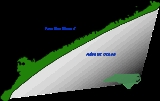
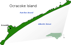 The island of Ocracoke is a part of the Outer Banks
of North Carolina
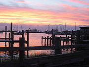
. It is one of the most remote islands in the Outer Banks, as it can only be reached by one of three public ferries (two of which are toll ferries), private boat, or private plane. Other than the village of Ocracoke and a few other areas (a ferry terminal, a pony pen, a small runway), the entire island is part of the Cape Hatteras National Seashore.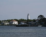 The village of Ocracoke is located around a small sheltered harbor
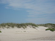
called Silver Lake, with a second smaller residential area built around a series of man-made canals called Oyster Creek. The village is located at the widest point of the island, protected from the Atlantic Ocean
by sand dunes and a salt marsh
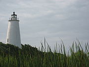
. The average height of the island is less than five feet above sea level, and many of the buildings on the island are built on pilings to lift them off the ground. Flooding is a risk during both hurricanes and large storms. Ocracoke Lighthouse is situated near Silver Lake and has remained in continuous operation since 1823.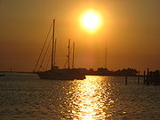 The island is also home to a British cemetery. During World War II
, German submarines sank several British ships including the HMT Bedfordshire
, and the bodies of British sailors were washed ashore. They were buried in a cemetery on the island. A lease for the 2290 square feet (212.7 m²) plot, where a British flag flies at all times, was given to the Commonwealth War Graves Commission
for as long as the land remained a cemetery, and the small site officially became a British cemetery. The United States Coast Guard station on Ocracoke Island takes care of the property. A memorial ceremony is held each year in May.
Ocracoke village is located at 35°6′46"N 75°58′33"W (35.112687, -75.975895). According to the United States Census Bureau
, the CDP has a total area of 9.6 square miles (24.9 km²), of which, 9.6 square miles (24.9 km²) of it is land and 0.1 square mile (0.258998811 km²) of it (0.62%) is water.
, runs from the village at the southern end of the island to the ferry dock at the northern tip of the island, where a 40-minute long free ferry connects to Hatteras Island
. The second ferry dock, located in the village, has toll connections to Swan Quarter, North Carolina
on the mainland and Cedar Island, near Atlantic, North Carolina
.
A passenger ferry operates across Ocracoke Inlet
to the deserted village of Portsmouth
, at the northern end of the Core Banks.
Ocracoke Island Airport (FAA Identifier W95) is located slightly south-east of the village, allowing small aircraft to land.
 The economy of Ocracoke Island is based almost entirely on tourism
. During the winter, the population shrinks and only a few businesses remain open. During the spring, summer, and early fall, an influx of tourists occupy hotels, campgrounds and weekly rental houses — and day visitors arrive by ferry from Hatteras Island
. Several bars, dozens of restaurants, and many shops, stores and other tourist-based businesses open for the tourist season, and every business on the island is independently owned and operated by residents. There are no chains or franchises.
Ocracoke was named America's Best Beach for 2007 by Dr. Stephen Leatherman
, a professor of coastal ecology at Florida International University
who compiles his annual list under the moniker "Dr. Beach". Ocracoke had previously earned the #2 and #3 spots in 2005 and 2006, respectively.
 Commercial fishing
contributes to the local economy with chartered sport fishing drawing tourism. With easy access to the Pamlico Sound
, the Atlantic coast
and the Gulf Stream
, Ocracoke offers various fishing opportunities, from small Sound fish to tuna
and drum.
During the winter, the island's only main employers are construction
, the NC Department of Transportation and the businesses that support the small population. Many islanders use the winter as time off, since they tend to work between 60 and 80 hours a week during the tourist season.
 Despite its small size, the island has a sizable music scene with a larger than normal percentage of its residents being musicians. The island hosts an annual Ocrafolk Festival featuring a weekend full of live performances. Besides the numerous restaurants which host live music, visitors and locals can attend the Ocrafolk Opry each Wednesday evening at the Deep Water Theater during the season, featuring a panoply of local musicians and special visiting guests. The only radio station licensed to a community in Hyde County, WOVV
90.1 FM has "Locals Only Beach" music blocks playing only the music of local bands. Several local stores carry cds produced by the island's musicians. Local musicians recently received national attention when they appeared performing in the movie Nights in Rodanthe
. Notable local musical acts include The Ocracoke Rockers, Martin and Friends, Aaron Caswell Band, Molasses Creek, Baby Dee and the Free Mustache Rides Again and Coyote. Other musical locals who left the island include Mya Rose
and Ansley Wynn of Incognito Mosquito.
, often referred to as a brogue
. A characteristic phrase is "high tide," pronounced somewhat like "hoi toid", and locals are referred to as high tider
s or hoi toiders. Due to the influx of tourists and greater contact with the mainland in recent years, however, the Ocracoke brogue has been increasingly influenced by outside dialects.
of 2000, there were 769 people, 370 households, and 219 families residing in the CDP. The population density
was 80.4 people per square mile (31.1/km²). There were 784 housing units at an average density of 82.0/sq mi (31.7/km²). The racial makeup of the CDP was 96.10% White, 1.69% African American, 0.52% Native American, 0.26% Asian, 0.65% from other races
, and 0.78% from two or more races. Hispanic or Latino of any race were 1.95% of the population.
 There were 370 households out of which 17.6% had children under the age of 18 living with them, 46.8% were married couples
living together, 8.9% had a female householder with no husband present, and 40.8% were non-families. 30.8% of all households were composed of individuals and 8.9% had someone living alone who was 65 years of age or older. The average household size was 2.08 and the average family size was 2.55.
In the CDP the population was spread out with 13.0% under the age of 18, 6.1% from 18 to 24, 28.3% from 25 to 44, 34.6% from 45 to 64, and 17.9% who were 65 years of age or older. The median age was 46 years. For every 100 females there were 96.2 males. For every 100 females age 18 and over, there were 89.0 males.
The median income for a household in the CDP was $34,315, and the median income for a family was $38,750. Males had a median income of $26,667 versus $25,625 for females. The per capita income
for the CDP was $18,032. About 7.7% of families and 9.3% of the population were below the poverty line, including 13.8% of those under age 18 and 10.4% of those age 65 or over.
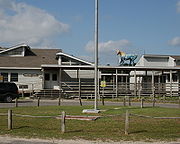
 The residents of Ocracoke Island are served by the Ocracoke School (K-12
), part of the Hyde County Schools
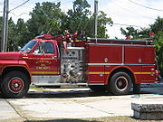
, located near the center of the village. The island also has a small, local airport located southeast of the village on NC 12. Hyde County maintains the Ocracoke Volunteer Fire Department located on the Back Road.
Census-designated place
A census-designated place is a concentration of population identified by the United States Census Bureau for statistical purposes. CDPs are delineated for each decennial census as the statistical counterparts of incorporated places such as cities, towns and villages...
(CDP) and unincorporated town located at the southern end of Ocracoke Island, located entirely within Hyde County
Hyde County, North Carolina
-National protected areas:* Alligator River National Wildlife Refuge * Cape Hatteras National Seashore * Mattamuskeet National Wildlife Refuge* Pocosin Lakes National Wildlife Refuge * Swanquarter National Wildlife Refuge-Demographics:...
, North Carolina
North Carolina
North Carolina is a state located in the southeastern United States. The state borders South Carolina and Georgia to the south, Tennessee to the west and Virginia to the north. North Carolina contains 100 counties. Its capital is Raleigh, and its largest city is Charlotte...
. The population was 769 as of the 2000 census. It is also the location of Blackbeard
Blackbeard
Edward Teach , better known as Blackbeard, was a notorious English pirate who operated around the West Indies and the eastern coast of the American colonies....
's death.
The Ocracoke area made headlines during the Independence Day weekend in July 2009 when a truck carrying fireworks exploded, eventually killing three, and injuring several more.
History
The Outer BanksOuter Banks
The Outer Banks is a 200-mile long string of narrow barrier islands off the coast of North Carolina, beginning in the southeastern corner of Virginia Beach on the east coast of the United States....
area was occasionally visited by Algonquian
Algonquian languages
The Algonquian languages also Algonkian) are a subfamily of Native American languages which includes most of the languages in the Algic language family. The name of the Algonquian language family is distinguished from the orthographically similar Algonquin dialect of the Ojibwe language, which is a...
-speaking Native Americans, but was never permanently settled. Ocracoke, then called Wokokkon, was used as a subsistence hunting and fishing ground for the Hatterask Indians. Yaupon Tea or Black Drink, made from the dried leaves of the indigenous yaupon, a native holly, was used ceremonially by the Native Americans in the area. A small village on Hatteras Island
Hatteras Island
Hatteras Island is a barrier island located off the North Carolina coast. Dividing the Atlantic Ocean and the Pamlico Sound, it runs parallel to the coast, forming a bend at Cape Hatteras. It is part of North Carolina's Outer Banks and includes the towns of Rodanthe, Waves, Salvo, Avon, Buxton,...
is said to have had forty fighting men. The area was first described in detail by Giovanni da Verrazzano, an Italian navigator, in 1524. Verrazzano was unable to navigate the tortuous channels leading into the Pamlico Sound
Pamlico Sound
Pamlico Sound in North Carolina, is the largest lagoon along the U.S. East Coast, being long and 24 to 48 km wide. It is a body of water separated from the Atlantic Ocean by the Outer Banks, a row of low, sandy barrier islands, including Cape Hatteras. The Neuse and Pamlico rivers flow in...
and assumed that China lay beyond the Outer Banks.
An attempt at an English settlement was tried at Roanoke Island
Roanoke Island
Roanoke Island is an island in Dare County near the coast of North Carolina, United States. It was named after the historical Roanoke Carolina Algonquian people who inhabited the area in the 16th century at the time of English exploration....
in the late 16th century, but it failed. This effectively halted European settlement until 1663, when Carolina Colony was chartered by King Charles II
Charles II of England
Charles II was monarch of the three kingdoms of England, Scotland, and Ireland.Charles II's father, King Charles I, was executed at Whitehall on 30 January 1649, at the climax of the English Civil War...
. However, remote Ocracoke Island was not permanently settled until 1750, being a pirate haven at times before then. It was a favorite anchorage of Edward Teach
Blackbeard
Edward Teach , better known as Blackbeard, was a notorious English pirate who operated around the West Indies and the eastern coast of the American colonies....
, better known as the pirate Blackbeard
Blackbeard
Edward Teach , better known as Blackbeard, was a notorious English pirate who operated around the West Indies and the eastern coast of the American colonies....
. He was killed in November 1718. The grounds of what is now the Springer's Point Nature Preserve were said to be the pirate's favored hang-out during those days.
Schooner
A schooner is a type of sailing vessel characterized by the use of fore-and-aft sails on two or more masts with the forward mast being no taller than the rear masts....
s to be delivered to plantations and towns along the mainland rivers.
By the late 19th century, the shipping business was gone, and the United States Lifesaving Service became a major source of steady income for local men. Fishing, including charters for tourists, became more important to the livelihood of the area.
Fort Ocracoke
Fort Ocracoke, a ConfederateConfederate States of America
The Confederate States of America was a government set up from 1861 to 1865 by 11 Southern slave states of the United States of America that had declared their secession from the U.S...
fortification constructed at the beginning of the American Civil War
American Civil War
The American Civil War was a civil war fought in the United States of America. In response to the election of Abraham Lincoln as President of the United States, 11 southern slave states declared their secession from the United States and formed the Confederate States of America ; the other 25...
, was situated on Beacon Island in Ocracoke Inlet, two miles to the west-southwest of Ocracoke village. The Confederates abandoned and partially destroyed the fort in August 1861 after Union
United States
The United States of America is a federal constitutional republic comprising fifty states and a federal district...
victories on nearby Hatteras Island
Hatteras Island
Hatteras Island is a barrier island located off the North Carolina coast. Dividing the Atlantic Ocean and the Pamlico Sound, it runs parallel to the coast, forming a bend at Cape Hatteras. It is part of North Carolina's Outer Banks and includes the towns of Rodanthe, Waves, Salvo, Avon, Buxton,...
. Union forces razed it a month later. Beacon Island subsided beneath the waves of the inlet in the early 20th century. The remnants of Fort Ocracoke were located and identified in 1998.
Geography
Outer Banks
The Outer Banks is a 200-mile long string of narrow barrier islands off the coast of North Carolina, beginning in the southeastern corner of Virginia Beach on the east coast of the United States....
of North Carolina
North Carolina
North Carolina is a state located in the southeastern United States. The state borders South Carolina and Georgia to the south, Tennessee to the west and Virginia to the north. North Carolina contains 100 counties. Its capital is Raleigh, and its largest city is Charlotte...
. It is one of the most remote islands in the Outer Banks, as it can only be reached by one of three public ferries (two of which are toll ferries), private boat, or private plane. Other than the village of Ocracoke and a few other areas (a ferry terminal, a pony pen, a small runway), the entire island is part of the Cape Hatteras National Seashore.
Harbor
A harbor or harbour , or haven, is a place where ships, boats, and barges can seek shelter from stormy weather, or else are stored for future use. Harbors can be natural or artificial...
called Silver Lake, with a second smaller residential area built around a series of man-made canals called Oyster Creek. The village is located at the widest point of the island, protected from the Atlantic Ocean
Atlantic Ocean
The Atlantic Ocean is the second-largest of the world's oceanic divisions. With a total area of about , it covers approximately 20% of the Earth's surface and about 26% of its water surface area...
by sand dunes and a salt marsh
Salt marsh
A salt marsh is an environment in the upper coastal intertidal zone between land and salt water or brackish water, it is dominated by dense stands of halophytic plants such as herbs, grasses, or low shrubs. These plants are terrestrial in origin and are essential to the stability of the salt marsh...
. The average height of the island is less than five feet above sea level, and many of the buildings on the island are built on pilings to lift them off the ground. Flooding is a risk during both hurricanes and large storms. Ocracoke Lighthouse is situated near Silver Lake and has remained in continuous operation since 1823.
World War II
World War II, or the Second World War , was a global conflict lasting from 1939 to 1945, involving most of the world's nations—including all of the great powers—eventually forming two opposing military alliances: the Allies and the Axis...
, German submarines sank several British ships including the HMT Bedfordshire
HMT Bedfordshire
HMT Bedfordshire was an armed anti-submarine trawler in the service of the Royal Navy during World War II. She was sunk by the Uboat U-558 on 11 May 1942 off the coast of Ocracoke Island on the Outer Banks of North Carolina, with the loss of all hands....
, and the bodies of British sailors were washed ashore. They were buried in a cemetery on the island. A lease for the 2290 square feet (212.7 m²) plot, where a British flag flies at all times, was given to the Commonwealth War Graves Commission
Commonwealth War Graves Commission
The Commonwealth War Graves Commission is an intergovernmental organisation of six independent member states whose principal function is to mark, record and maintain the graves, and places of commemoration, of Commonwealth of Nations military service members who died in the two World Wars...
for as long as the land remained a cemetery, and the small site officially became a British cemetery. The United States Coast Guard station on Ocracoke Island takes care of the property. A memorial ceremony is held each year in May.
Ocracoke village is located at 35°6′46"N 75°58′33"W (35.112687, -75.975895). According to the United States Census Bureau
United States Census Bureau
The United States Census Bureau is the government agency that is responsible for the United States Census. It also gathers other national demographic and economic data...
, the CDP has a total area of 9.6 square miles (24.9 km²), of which, 9.6 square miles (24.9 km²) of it is land and 0.1 square mile (0.258998811 km²) of it (0.62%) is water.
Transportation
A single paved two-lane road, NC 12North Carolina State Highway 12
NC 12 is a North Carolina state highway that traverses the northeastern shoreline of North Carolina, linking the islands of the Outer Banks. It is a popular route for visitors touring the Outer Banks...
, runs from the village at the southern end of the island to the ferry dock at the northern tip of the island, where a 40-minute long free ferry connects to Hatteras Island
Hatteras Island
Hatteras Island is a barrier island located off the North Carolina coast. Dividing the Atlantic Ocean and the Pamlico Sound, it runs parallel to the coast, forming a bend at Cape Hatteras. It is part of North Carolina's Outer Banks and includes the towns of Rodanthe, Waves, Salvo, Avon, Buxton,...
. The second ferry dock, located in the village, has toll connections to Swan Quarter, North Carolina
Swan Quarter, North Carolina
Swan Quarter is an unincorporated village in and the county seat of Hyde County, North Carolina, United States.- Geography :...
on the mainland and Cedar Island, near Atlantic, North Carolina
Atlantic, North Carolina
Atlantic is an unincorporated community in eastern Carteret County situated along the Core Sound, located in what was known to early settlers of the area as Hunting Quarters. It is the location of US 70's eastern terminus and the ferry terminal for journeys to North Core Banks in the Cape Lookout...
.
A passenger ferry operates across Ocracoke Inlet
Ocracoke Inlet
Ocracoke Inlet is an estuary located in the Outer Banks, North Carolina, United States that separates Ocracoke Island and Portsmouth Island. It connects the Atlantic Ocean to the Pamlico Sound. It is the southern terminus of the Cape Hatteras National Seashore. It is the northern terminus of the...
to the deserted village of Portsmouth
Portsmouth, North Carolina
Portsmouth was a fishing and shipping village located on the north end of the Core Banks on the Outer Banks in North Carolina. The site lies on Portsmouth Island in Carteret County, across Ocracoke Inlet from the village of Ocracoke. The town was established in 1753, and abandoned in 1971...
, at the northern end of the Core Banks.
Ocracoke Island Airport (FAA Identifier W95) is located slightly south-east of the village, allowing small aircraft to land.
Economy
Tourism
Tourism is travel for recreational, leisure or business purposes. The World Tourism Organization defines tourists as people "traveling to and staying in places outside their usual environment for not more than one consecutive year for leisure, business and other purposes".Tourism has become a...
. During the winter, the population shrinks and only a few businesses remain open. During the spring, summer, and early fall, an influx of tourists occupy hotels, campgrounds and weekly rental houses — and day visitors arrive by ferry from Hatteras Island
Hatteras Island
Hatteras Island is a barrier island located off the North Carolina coast. Dividing the Atlantic Ocean and the Pamlico Sound, it runs parallel to the coast, forming a bend at Cape Hatteras. It is part of North Carolina's Outer Banks and includes the towns of Rodanthe, Waves, Salvo, Avon, Buxton,...
. Several bars, dozens of restaurants, and many shops, stores and other tourist-based businesses open for the tourist season, and every business on the island is independently owned and operated by residents. There are no chains or franchises.
Ocracoke was named America's Best Beach for 2007 by Dr. Stephen Leatherman
Stephen Leatherman
Stephen P. Leatherman is the director of the Laboratory for Coastal Research at Florida International University.In addition to his educational duties, Dr. Leatherman is known for his annual rankings of American beaches, thus earning him the nickname "Dr. Beach".-Education:Leatherman earned his...
, a professor of coastal ecology at Florida International University
Florida International University
Florida International University is an American public research university in metropolitan Miami, Florida, in the United States, with its main campus in University Park...
who compiles his annual list under the moniker "Dr. Beach". Ocracoke had previously earned the #2 and #3 spots in 2005 and 2006, respectively.
Fishing
Fishing is the activity of trying to catch wild fish. Fish are normally caught in the wild. Techniques for catching fish include hand gathering, spearing, netting, angling and trapping....
contributes to the local economy with chartered sport fishing drawing tourism. With easy access to the Pamlico Sound
Pamlico Sound
Pamlico Sound in North Carolina, is the largest lagoon along the U.S. East Coast, being long and 24 to 48 km wide. It is a body of water separated from the Atlantic Ocean by the Outer Banks, a row of low, sandy barrier islands, including Cape Hatteras. The Neuse and Pamlico rivers flow in...
, the Atlantic coast
Atlantic Ocean
The Atlantic Ocean is the second-largest of the world's oceanic divisions. With a total area of about , it covers approximately 20% of the Earth's surface and about 26% of its water surface area...
and the Gulf Stream
Gulf Stream
The Gulf Stream, together with its northern extension towards Europe, the North Atlantic Drift, is a powerful, warm, and swift Atlantic ocean current that originates at the tip of Florida, and follows the eastern coastlines of the United States and Newfoundland before crossing the Atlantic Ocean...
, Ocracoke offers various fishing opportunities, from small Sound fish to tuna
Tuna
Tuna is a salt water fish from the family Scombridae, mostly in the genus Thunnus. Tuna are fast swimmers, and some species are capable of speeds of . Unlike most fish, which have white flesh, the muscle tissue of tuna ranges from pink to dark red. The red coloration derives from myoglobin, an...
and drum.
During the winter, the island's only main employers are construction
Construction
In the fields of architecture and civil engineering, construction is a process that consists of the building or assembling of infrastructure. Far from being a single activity, large scale construction is a feat of human multitasking...
, the NC Department of Transportation and the businesses that support the small population. Many islanders use the winter as time off, since they tend to work between 60 and 80 hours a week during the tourist season.
Music
WOVV
WOVV is a planned FM radio station and current internet radio station with a FCC issued construction permit for Ocracoke, North Carolina, USA. The station is currently owned by Ocracoke Foundation....
90.1 FM has "Locals Only Beach" music blocks playing only the music of local bands. Several local stores carry cds produced by the island's musicians. Local musicians recently received national attention when they appeared performing in the movie Nights in Rodanthe
Nights in Rodanthe
Nights in Rodanthe is a 2008 American/Australian film adaptation of the novel with the same name by Nicholas Sparks. The film stars Richard Gere and Diane Lane in their third screen collaboration after Unfaithful and The Cotton Club . The film is rated PG-13 by the MPAA for "some sensuality" and...
. Notable local musical acts include The Ocracoke Rockers, Martin and Friends, Aaron Caswell Band, Molasses Creek, Baby Dee and the Free Mustache Rides Again and Coyote. Other musical locals who left the island include Mya Rose
Mya Rose
Mya Rose Gill is an indie folk-alternative artist, born September 4, 1979 . She has spent the last 13 years gigging around the world from huge stages to street corners, from Korea to England, California to North Carolina...
and Ansley Wynn of Incognito Mosquito.
Local dialect
Ocracoke Island historically had its own distinct dialect of EnglishEnglish language
English is a West Germanic language that arose in the Anglo-Saxon kingdoms of England and spread into what was to become south-east Scotland under the influence of the Anglian medieval kingdom of Northumbria...
, often referred to as a brogue
Brogue
A brogue is a strong accent, notably in Irish dialects of English. For example, in the folksong "Finnegan's Wake", the character of the song, Tim Finnegan, was said to have a "beautiful brogue so rich and sweet"....
. A characteristic phrase is "high tide," pronounced somewhat like "hoi toid", and locals are referred to as high tider
High tider
"High Tider" or sometimes "Hoi Toider" is a nickname for a native of the rural eastern coast region of the U.S. state of North Carolina, specifically from several small townships such as Atlantic, Smyrna, Sea Level, and Harkers Island in eastern Carteret County, and from Ocracoke...
s or hoi toiders. Due to the influx of tourists and greater contact with the mainland in recent years, however, the Ocracoke brogue has been increasingly influenced by outside dialects.
Demographics
As of the censusCensus
A census is the procedure of systematically acquiring and recording information about the members of a given population. It is a regularly occurring and official count of a particular population. The term is used mostly in connection with national population and housing censuses; other common...
of 2000, there were 769 people, 370 households, and 219 families residing in the CDP. The population density
Population density
Population density is a measurement of population per unit area or unit volume. It is frequently applied to living organisms, and particularly to humans...
was 80.4 people per square mile (31.1/km²). There were 784 housing units at an average density of 82.0/sq mi (31.7/km²). The racial makeup of the CDP was 96.10% White, 1.69% African American, 0.52% Native American, 0.26% Asian, 0.65% from other races
Race (United States Census)
Race and ethnicity in the United States Census, as defined by the Federal Office of Management and Budget and the United States Census Bureau, are self-identification data items in which residents choose the race or races with which they most closely identify, and indicate whether or not they are...
, and 0.78% from two or more races. Hispanic or Latino of any race were 1.95% of the population.
Marriage
Marriage is a social union or legal contract between people that creates kinship. It is an institution in which interpersonal relationships, usually intimate and sexual, are acknowledged in a variety of ways, depending on the culture or subculture in which it is found...
living together, 8.9% had a female householder with no husband present, and 40.8% were non-families. 30.8% of all households were composed of individuals and 8.9% had someone living alone who was 65 years of age or older. The average household size was 2.08 and the average family size was 2.55.
In the CDP the population was spread out with 13.0% under the age of 18, 6.1% from 18 to 24, 28.3% from 25 to 44, 34.6% from 45 to 64, and 17.9% who were 65 years of age or older. The median age was 46 years. For every 100 females there were 96.2 males. For every 100 females age 18 and over, there were 89.0 males.
The median income for a household in the CDP was $34,315, and the median income for a family was $38,750. Males had a median income of $26,667 versus $25,625 for females. The per capita income
Per capita income
Per capita income or income per person is a measure of mean income within an economic aggregate, such as a country or city. It is calculated by taking a measure of all sources of income in the aggregate and dividing it by the total population...
for the CDP was $18,032. About 7.7% of families and 9.3% of the population were below the poverty line, including 13.8% of those under age 18 and 10.4% of those age 65 or over.
Public services
K-12
K–12 is a designation for the sum of primary and secondary education. It is used in the United States, Canada, Australia, and New Zealand where P–12 is also commonly used...
), part of the Hyde County Schools
Hyde County Schools
Hyde County Schools is a public school district in Hyde County, North Carolina. It currently operates two K-12 schools....
, located near the center of the village. The island also has a small, local airport located southeast of the village on NC 12. Hyde County maintains the Ocracoke Volunteer Fire Department located on the Back Road.