
.gif)
Hurricane Alex (2004)
Encyclopedia
Hurricane Alex was the first named storm
, the first hurricane
, and the first major hurricane of the 2004 Atlantic hurricane season
. The first storm of the season, Alex formed unusually late in the season; the fifth latest since 1954. It developed from the interaction between an upper-level low and a weak surface trough
on July 31 to the east of Jacksonville, Florida
. It moved northeastward, and strengthened to attain winds of 100 mph (160 km/h) before passing within 10 miles (16 km) of the Outer Banks
coast. Alex strengthened further and reached a peak of 120 mph (190 km/h) winds while off the coast of New England
, one of only two hurricanes to reach Category 3
status north of 38° N. Alex caused a scare of a hurricane-force direct hit in the Outer Banks
of North Carolina
, which had been devastated by Hurricane Isabel
less than a year earlier.
The hurricane produced light damage in the Outer Banks
, primarily from flooding and high winds. Over 100 houses were damaged, while numerous cars were disabled from the flooding. Damage totaled about $7.5 million (2004 USD). Alex produced strong waves and rip tides along the East Coast of the United States
, causing one death and several injuries.
, located to the west of an upper-level low, developed convection to the east of the Bahamas on July 26. A tropical wave entered the area two days later, resulting in an increase of convective organization and area. Although conditions were not favorable for tropical cyclone formation, it sped to the northwest and steadily organized, developing a surface area of low pressure on the 30th. On July 31, the system continued to organize, and developed into Tropical Depression One while located 200 miles (320 km) to the east of Jacksonville, Florida
.
As the depression drifted erratically, the system remained weak due to its large circulation and lack of deep convection near the center. The center relocated to the south, closer to the center. An approaching upper-level trough lessened the shear over the system, allowing the depression to intensify into Tropical Storm Alex on August 1. The trough also caused Alex to increase its forward motion to the northeast. Deep convection continued to build over the center due to low shear and warm waters from the Gulf Stream
, and Alex intensified into a hurricane on August 3 while located 75 miles (120 km) southeast of Cape Fear, North Carolina
. The cyclone continued to strengthen, and attained Category 2 status
just hours after becoming a hurricane. The hurricane approached the Outer Banks
of North Carolina
, coming within 10 miles (16 km) of Cape Hatteras later on the 3rd. The western portion of the eyewall
passed over the Outer Banks, though the center remained offshore.
 Alex turned to the east-northeast after passing the Outer Banks in response to becoming embedded within the west-southwesterly flow. The hurricane briefly weakened to a Category 1, but restrengthened due to warm waters of the Gulf Stream
. Water temperatures remained 3.6°F (2°C) above normal, resulting in Alex intensifying into a 120 mph (195 km/h) major hurricane on August 5 while located 450 miles (710 km) south of Halifax, Nova Scotia
. Due to low vertical shear and favorable conditions, Alex remained a Category 3 hurricane until passing over cooler waters late on the 5th while 290 miles (465 km) south of Newfoundland. Alex rapidly weakened, degrading into tropical storm status on August 6. Later on the 6th, Alex became extratropical while 950 miles (1530 km) east of Cape Race
, Newfoundland, and lost its identity shortly thereafter.
from Cape Lookout
to Oregon Inlet
about 20 hours before hurricane conditions were experienced. In addition, a tropical storm warning existed for much of the North Carolina coastline as Alex paralleled the state.
Despite Tropical Storm Warnings, 3,500 tourists remained on the Outer Banks
, though many planned to leave if Alex were to track closer or become stronger. No evacuations were ordered. Officials recommended residents to take precautions for the approaching hurricane. The National Weather Service
in Morehead City
issued a flash flood watch
a day before the hurricane moved passed the Outer Banks. The service also issued flash flooding warnings for Craven
and Carteret Counties
on the day of the hurricane's closest approach. In preparation for the hurricane, the Cape Lookout National Seashore
was closed and evacuated. The National Park Service also closed Cape Point Campground.
 While drifting off the coast of Florida
, Alex produced rip currents and strong waves along the North Carolina
coast resulting in nine lifeguard rescues from the surf. Upon moving by the Outer Banks
, a storm surge of up to 6 feet (1.8 m) occurred on the Pamlico Sound
side of Buxton
and Ocracoke Village
. The flooding on Ocracoke Island was the worst since Hurricane Gloria
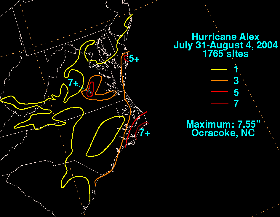
nineteen years earlier. Elsewhere on the Outer Banks, waters rose 2–4 feet (0.6–1.2 m) above normal. Rainfall directly along the coast amounted to over 5 inches (127 mm), while Ocracoke experienced 7.55 inches (192 mm). Maximum sustained winds peaked at 88 mph (124 km/h), and gusts peaked at 115 mph (169 km/h) in Morehead City. Beach erosion was minor along much of North Carolina's coastline, with the exception of Ocracoke Island where erosion was significant.
Cape Fear experienced minor beach erosion. The erosion, combined with high waves, washed out a portion of a roadway. The heavy rainfall in the Outer Banks disabled over 200 cars and flooded nearly 500. Strong wind gusts left around 10,000 buildings without power. Many places were not restored for two to three days after the storm. Wind and storm surge damaged over 100 houses and buildings. Damage amounted to about $7.5 million (2004 USD). Two days after the storm passed, a man drowned off of Nags Head
from strong rip currents and waves. This was the only direct casualty from the storm.
Alex's outer rainbands produced heavy rainfall across Virginia
, peaking at over 7 inches (178 mm) in the center of the state. The rainfall caused localized flooding, but there was no reported damage in the state. In Rehoboth Beach, Delaware
, rip currents produced by the storm injured three people. A few young children had to be rescued when they were trapped by a jetty. In New Jersey
, the strong surf and rip currents hospitalized at least five swimmers.
Alex's extratropical remnants sank the Pink Lady, a rowboat carrying four British rowers attempting to break the record for fastest crossing from St. John's, Newfoundland
to Falmouth, Cornwall
. They were rescued by a Danish cargo ship, and injuries were limited to a mild concussion and a case of hypothermia
. The rowers were roughly two weeks and 370 miles (595 km) from their destination. The group had been on track to break the 1896 record of 54 days by 10 days.
 On Ocracoke Island, officials ordered for the evacuation of the thousands of tourists who stayed, believing that keeping tourists on the island would hinder cleanup efforts. The tourists were evacuated in school buses to Hatteras Island, where they could rent a car if needed. Tourists were also evacuated by ferry to Swan Quarter, in Hyde County, where they boarded school buses and were taken to nearby Washington NC to rent available cars or find accommodations. The island was re-opened to visitors on August 6, three days after the storm passed through. Evacuation was ordered again on Friday of the following week when another storm threatened to hit the Outer Banks, but did not do so. Dare County
officials requested aid from the National Guard
for the cleanup process. The North Carolina Department of Transportation was ready to clear the roads once the storm exited the area.
Alex marked the fifth-latest start to a hurricane season since 1954. The latest start to a hurricane season since 1954 was Hurricane Anita
of the 1977 season
, forming on August 29. Alex is only the second hurricane on record to have reached Category 3 strength north of 38°N latitude. The other storm was Hurricane Ellen in the 1973 Atlantic hurricane season
; Alex was the stronger of the two.
Tropical cyclone
A tropical cyclone is a storm system characterized by a large low-pressure center and numerous thunderstorms that produce strong winds and heavy rain. Tropical cyclones strengthen when water evaporated from the ocean is released as the saturated air rises, resulting in condensation of water vapor...
, the first hurricane
Tropical cyclone
A tropical cyclone is a storm system characterized by a large low-pressure center and numerous thunderstorms that produce strong winds and heavy rain. Tropical cyclones strengthen when water evaporated from the ocean is released as the saturated air rises, resulting in condensation of water vapor...
, and the first major hurricane of the 2004 Atlantic hurricane season
2004 Atlantic hurricane season
The 2004 Atlantic hurricane season officially began on June 1, 2004, and lasted until November 30, 2004. These dates conventionally delimit the period of each year when most tropical cyclones form in the Atlantic basin...
. The first storm of the season, Alex formed unusually late in the season; the fifth latest since 1954. It developed from the interaction between an upper-level low and a weak surface trough
Trough (meteorology)
A trough is an elongated region of relatively low atmospheric pressure, often associated with fronts.Unlike fronts, there is not a universal symbol for a trough on a weather chart. The weather charts in some countries or regions mark troughs by a line. In the United States, a trough may be marked...
on July 31 to the east of Jacksonville, Florida
Jacksonville, Florida
Jacksonville is the largest city in the U.S. state of Florida in terms of both population and land area, and the largest city by area in the contiguous United States. It is the county seat of Duval County, with which the city government consolidated in 1968...
. It moved northeastward, and strengthened to attain winds of 100 mph (160 km/h) before passing within 10 miles (16 km) of the Outer Banks
Outer Banks
The Outer Banks is a 200-mile long string of narrow barrier islands off the coast of North Carolina, beginning in the southeastern corner of Virginia Beach on the east coast of the United States....
coast. Alex strengthened further and reached a peak of 120 mph (190 km/h) winds while off the coast of New England
New England
New England is a region in the northeastern corner of the United States consisting of the six states of Maine, New Hampshire, Vermont, Massachusetts, Rhode Island, and Connecticut...
, one of only two hurricanes to reach Category 3
Saffir-Simpson Hurricane Scale
The Saffir–Simpson Hurricane Scale , or the Saffir–Simpson Hurricane Wind Scale , classifies hurricanes — Western Hemisphere tropical cyclones that exceed the intensities of tropical depressions and tropical storms — into five categories distinguished by the intensities of their sustained winds...
status north of 38° N. Alex caused a scare of a hurricane-force direct hit in the Outer Banks
Outer Banks
The Outer Banks is a 200-mile long string of narrow barrier islands off the coast of North Carolina, beginning in the southeastern corner of Virginia Beach on the east coast of the United States....
of North Carolina
North Carolina
North Carolina is a state located in the southeastern United States. The state borders South Carolina and Georgia to the south, Tennessee to the west and Virginia to the north. North Carolina contains 100 counties. Its capital is Raleigh, and its largest city is Charlotte...
, which had been devastated by Hurricane Isabel
Hurricane Isabel
Hurricane Isabel was the costliest and deadliest hurricane in the 2003 Atlantic hurricane season. The ninth named storm, fifth hurricane, and second major hurricane of the season, Isabel formed near the Cape Verde Islands from a tropical wave on September 6 in the tropical Atlantic Ocean...
less than a year earlier.
The hurricane produced light damage in the Outer Banks
Outer Banks
The Outer Banks is a 200-mile long string of narrow barrier islands off the coast of North Carolina, beginning in the southeastern corner of Virginia Beach on the east coast of the United States....
, primarily from flooding and high winds. Over 100 houses were damaged, while numerous cars were disabled from the flooding. Damage totaled about $7.5 million (2004 USD). Alex produced strong waves and rip tides along the East Coast of the United States
East Coast of the United States
The East Coast of the United States, also known as the Eastern Seaboard, refers to the easternmost coastal states in the United States, which touch the Atlantic Ocean and stretch up to Canada. The term includes the U.S...
, causing one death and several injuries.
Meteorological history
A weak surface troughTrough (meteorology)
A trough is an elongated region of relatively low atmospheric pressure, often associated with fronts.Unlike fronts, there is not a universal symbol for a trough on a weather chart. The weather charts in some countries or regions mark troughs by a line. In the United States, a trough may be marked...
, located to the west of an upper-level low, developed convection to the east of the Bahamas on July 26. A tropical wave entered the area two days later, resulting in an increase of convective organization and area. Although conditions were not favorable for tropical cyclone formation, it sped to the northwest and steadily organized, developing a surface area of low pressure on the 30th. On July 31, the system continued to organize, and developed into Tropical Depression One while located 200 miles (320 km) to the east of Jacksonville, Florida
Jacksonville, Florida
Jacksonville is the largest city in the U.S. state of Florida in terms of both population and land area, and the largest city by area in the contiguous United States. It is the county seat of Duval County, with which the city government consolidated in 1968...
.
As the depression drifted erratically, the system remained weak due to its large circulation and lack of deep convection near the center. The center relocated to the south, closer to the center. An approaching upper-level trough lessened the shear over the system, allowing the depression to intensify into Tropical Storm Alex on August 1. The trough also caused Alex to increase its forward motion to the northeast. Deep convection continued to build over the center due to low shear and warm waters from the Gulf Stream
Gulf Stream
The Gulf Stream, together with its northern extension towards Europe, the North Atlantic Drift, is a powerful, warm, and swift Atlantic ocean current that originates at the tip of Florida, and follows the eastern coastlines of the United States and Newfoundland before crossing the Atlantic Ocean...
, and Alex intensified into a hurricane on August 3 while located 75 miles (120 km) southeast of Cape Fear, North Carolina
North Carolina
North Carolina is a state located in the southeastern United States. The state borders South Carolina and Georgia to the south, Tennessee to the west and Virginia to the north. North Carolina contains 100 counties. Its capital is Raleigh, and its largest city is Charlotte...
. The cyclone continued to strengthen, and attained Category 2 status
Saffir-Simpson Hurricane Scale
The Saffir–Simpson Hurricane Scale , or the Saffir–Simpson Hurricane Wind Scale , classifies hurricanes — Western Hemisphere tropical cyclones that exceed the intensities of tropical depressions and tropical storms — into five categories distinguished by the intensities of their sustained winds...
just hours after becoming a hurricane. The hurricane approached the Outer Banks
Outer Banks
The Outer Banks is a 200-mile long string of narrow barrier islands off the coast of North Carolina, beginning in the southeastern corner of Virginia Beach on the east coast of the United States....
of North Carolina
North Carolina
North Carolina is a state located in the southeastern United States. The state borders South Carolina and Georgia to the south, Tennessee to the west and Virginia to the north. North Carolina contains 100 counties. Its capital is Raleigh, and its largest city is Charlotte...
, coming within 10 miles (16 km) of Cape Hatteras later on the 3rd. The western portion of the eyewall
Eye (cyclone)
The eye is a region of mostly calm weather found at the center of strong tropical cyclones. The eye of a storm is a roughly circular area and typically 30–65 km in diameter. It is surrounded by the eyewall, a ring of towering thunderstorms where the second most severe weather of a cyclone...
passed over the Outer Banks, though the center remained offshore.
Gulf Stream
The Gulf Stream, together with its northern extension towards Europe, the North Atlantic Drift, is a powerful, warm, and swift Atlantic ocean current that originates at the tip of Florida, and follows the eastern coastlines of the United States and Newfoundland before crossing the Atlantic Ocean...
. Water temperatures remained 3.6°F (2°C) above normal, resulting in Alex intensifying into a 120 mph (195 km/h) major hurricane on August 5 while located 450 miles (710 km) south of Halifax, Nova Scotia
Halifax Regional Municipality, Nova Scotia
Halifax Regional Municipality is the capital of the province of Nova Scotia, Canada. The Regional Municipality had a 2006 census population of 372,679, while the metropolitan area had a 2010 estimated population of 403,188, and the urban area of Halifax had a population of 282,924...
. Due to low vertical shear and favorable conditions, Alex remained a Category 3 hurricane until passing over cooler waters late on the 5th while 290 miles (465 km) south of Newfoundland. Alex rapidly weakened, degrading into tropical storm status on August 6. Later on the 6th, Alex became extratropical while 950 miles (1530 km) east of Cape Race
Cape Race
Cape Race is a point of land located at the southeastern tip of the Avalon Peninsula on the island of Newfoundland, Canada. Its name is thought to come from the original Portuguese name for this cape, "Raso", or "bare"...
, Newfoundland, and lost its identity shortly thereafter.
Preparations
Initially, forecasters believed Alex would remain weak, and on the first advisory the storm was predicted to make landfall as a minimal tropical storm. However, when strengthening became evident, the National Hurricane Center issued a hurricane warningTropical cyclone warnings and watches
Warnings and watches are two levels of alert issued by national weather forecasting bodies to coastal areas threatened by the imminent approach of a tropical cyclone of tropical storm or hurricane intensity. They are notices to the local population and civil authorities to make appropriate...
from Cape Lookout
Cape Lookout
Cape Lookout can refer to:*Cape Lookout , in the United States*Cape Lookout , in the United States*Cape Lookout...
to Oregon Inlet
Oregon Inlet
Oregon Inlet is an inlet along North Carolina's Outer Banks. It joins the Pamlico Sound with the Atlantic Ocean and separates Bodie Island from Pea Island, which are connected by a 2.5 mile bridge that spans the inlet...
about 20 hours before hurricane conditions were experienced. In addition, a tropical storm warning existed for much of the North Carolina coastline as Alex paralleled the state.
Despite Tropical Storm Warnings, 3,500 tourists remained on the Outer Banks
Outer Banks
The Outer Banks is a 200-mile long string of narrow barrier islands off the coast of North Carolina, beginning in the southeastern corner of Virginia Beach on the east coast of the United States....
, though many planned to leave if Alex were to track closer or become stronger. No evacuations were ordered. Officials recommended residents to take precautions for the approaching hurricane. The National Weather Service
National Weather Service
The National Weather Service , once known as the Weather Bureau, is one of the six scientific agencies that make up the National Oceanic and Atmospheric Administration of the United States government...
in Morehead City
Morehead City, North Carolina
Morehead City is a port city in Carteret County, North Carolina, United States. The population was 8,661 at the 2010 census. Morehead City celebrated the 150th anniversary of its founding on May 5, 2007...
issued a flash flood watch
Flood watch
Flood alerts are issued by weather agencies to alert residents that flood conditions are a possibility for their area.-Types of flood alerts:...
a day before the hurricane moved passed the Outer Banks. The service also issued flash flooding warnings for Craven
Craven County, North Carolina
Craven County is a county located in the U.S. state of North Carolina. The estimated population in 2006 was 94,875. Its county seat is New Bern.Craven County is part of the New Bern, North Carolina, Micropolitan Statistical Area.-History:...
and Carteret Counties
Carteret County, North Carolina
Carteret County is a county located in the U.S. state of North Carolina. As of 2010, the population was 66,469. Its county seat is Beaufort. Most of the county is part of the Crystal Coast....
on the day of the hurricane's closest approach. In preparation for the hurricane, the Cape Lookout National Seashore
Cape Lookout National Seashore
Cape Lookout National Seashore preserves a 56-mile long section of the Southern Outer Banks, or Crystal Coast, of North Carolina, USA, running from Ocracoke Inlet on the northeast to Beaufort Inlet on the southeast. Three undeveloped barrier islands make up the seashore - North Core Banks, South...
was closed and evacuated. The National Park Service also closed Cape Point Campground.
Impact
Florida
Florida is a state in the southeastern United States, located on the nation's Atlantic and Gulf coasts. It is bordered to the west by the Gulf of Mexico, to the north by Alabama and Georgia and to the east by the Atlantic Ocean. With a population of 18,801,310 as measured by the 2010 census, it...
, Alex produced rip currents and strong waves along the North Carolina
North Carolina
North Carolina is a state located in the southeastern United States. The state borders South Carolina and Georgia to the south, Tennessee to the west and Virginia to the north. North Carolina contains 100 counties. Its capital is Raleigh, and its largest city is Charlotte...
coast resulting in nine lifeguard rescues from the surf. Upon moving by the Outer Banks
Outer Banks
The Outer Banks is a 200-mile long string of narrow barrier islands off the coast of North Carolina, beginning in the southeastern corner of Virginia Beach on the east coast of the United States....
, a storm surge of up to 6 feet (1.8 m) occurred on the Pamlico Sound
Pamlico Sound
Pamlico Sound in North Carolina, is the largest lagoon along the U.S. East Coast, being long and 24 to 48 km wide. It is a body of water separated from the Atlantic Ocean by the Outer Banks, a row of low, sandy barrier islands, including Cape Hatteras. The Neuse and Pamlico rivers flow in...
side of Buxton
Buxton, North Carolina
Buxton is an unincorporated community of nearly 1,500 people on Hatteras Island near Cape Hatteras. It is located in Dare County in the U.S. state of North Carolina. North Carolina Highway 12 links the community to other Outer Banks communities such as Avon, Frisco, and Hatteras...
and Ocracoke Village
Ocracoke, North Carolina
Ocracoke is a census-designated place and unincorporated town located at the southern end of Ocracoke Island, located entirely within Hyde County, North Carolina. The population was 769 as of the 2000 census...
. The flooding on Ocracoke Island was the worst since Hurricane Gloria
Hurricane Gloria
Hurricane Gloria was a powerful Cape Verde-type hurricane that formed during the 1985 Atlantic hurricane season and prowled the Atlantic Ocean from September 16 to September 28. Gloria reached Category 4 status on the Saffir-Simpson Hurricane Scale near the Bahamas, but weakened significantly...
nineteen years earlier. Elsewhere on the Outer Banks, waters rose 2–4 feet (0.6–1.2 m) above normal. Rainfall directly along the coast amounted to over 5 inches (127 mm), while Ocracoke experienced 7.55 inches (192 mm). Maximum sustained winds peaked at 88 mph (124 km/h), and gusts peaked at 115 mph (169 km/h) in Morehead City. Beach erosion was minor along much of North Carolina's coastline, with the exception of Ocracoke Island where erosion was significant.
Cape Fear experienced minor beach erosion. The erosion, combined with high waves, washed out a portion of a roadway. The heavy rainfall in the Outer Banks disabled over 200 cars and flooded nearly 500. Strong wind gusts left around 10,000 buildings without power. Many places were not restored for two to three days after the storm. Wind and storm surge damaged over 100 houses and buildings. Damage amounted to about $7.5 million (2004 USD). Two days after the storm passed, a man drowned off of Nags Head
Nags Head, North Carolina
Nags Head is a town in Dare County, North Carolina, United States. The population was 2,700 at the 2000 census.-History:Early maps of the area show Nags Head as a promontory of land characterized by high sand dunes visible from miles at sea...
from strong rip currents and waves. This was the only direct casualty from the storm.
Alex's outer rainbands produced heavy rainfall across Virginia
Virginia
The Commonwealth of Virginia , is a U.S. state on the Atlantic Coast of the Southern United States. Virginia is nicknamed the "Old Dominion" and sometimes the "Mother of Presidents" after the eight U.S. presidents born there...
, peaking at over 7 inches (178 mm) in the center of the state. The rainfall caused localized flooding, but there was no reported damage in the state. In Rehoboth Beach, Delaware
Rehoboth Beach, Delaware
Rehoboth Beach is a city in Sussex County, Delaware, United States. According to the 2010 census, the population is 1,327, a decrease of 11.2% from 2000...
, rip currents produced by the storm injured three people. A few young children had to be rescued when they were trapped by a jetty. In New Jersey
New Jersey
New Jersey is a state in the Northeastern and Middle Atlantic regions of the United States. , its population was 8,791,894. It is bordered on the north and east by the state of New York, on the southeast and south by the Atlantic Ocean, on the west by Pennsylvania and on the southwest by Delaware...
, the strong surf and rip currents hospitalized at least five swimmers.
Alex's extratropical remnants sank the Pink Lady, a rowboat carrying four British rowers attempting to break the record for fastest crossing from St. John's, Newfoundland
St. John's, Newfoundland and Labrador
St. John's is the capital and largest city in Newfoundland and Labrador, and is the oldest English-founded city in North America. It is located on the eastern tip of the Avalon Peninsula on the island of Newfoundland. With a population of 192,326 as of July 1, 2010, the St...
to Falmouth, Cornwall
Falmouth, Cornwall
Falmouth is a town, civil parish and port on the River Fal on the south coast of Cornwall, England, United Kingdom. It has a total resident population of 21,635.Falmouth is the terminus of the A39, which begins some 200 miles away in Bath, Somerset....
. They were rescued by a Danish cargo ship, and injuries were limited to a mild concussion and a case of hypothermia
Hypothermia
Hypothermia is a condition in which core temperature drops below the required temperature for normal metabolism and body functions which is defined as . Body temperature is usually maintained near a constant level of through biologic homeostasis or thermoregulation...
. The rowers were roughly two weeks and 370 miles (595 km) from their destination. The group had been on track to break the 1896 record of 54 days by 10 days.
Aftermath and records
Dare County, North Carolina
-National protected areas:* Alligator River National Wildlife Refuge * Cape Hatteras National Seashore * Fort Raleigh National Historic Site* Pea Island National Wildlife Refuge* Wright Brothers National Memorial-Demographics:...
officials requested aid from the National Guard
United States National Guard
The National Guard of the United States is a reserve military force composed of state National Guard militia members or units under federally recognized active or inactive armed force service for the United States. Militia members are citizen soldiers, meaning they work part time for the National...
for the cleanup process. The North Carolina Department of Transportation was ready to clear the roads once the storm exited the area.
Alex marked the fifth-latest start to a hurricane season since 1954. The latest start to a hurricane season since 1954 was Hurricane Anita
Hurricane Anita
Hurricane Anita was a powerful Atlantic hurricane during an otherwise quiet 1977 Atlantic hurricane season. The first tropical cyclone of the season, Anita developed from a tropical wave on August 29 in the north-central Gulf of Mexico. It tracked westward into an area with conditions favorable for...
of the 1977 season
1977 Atlantic hurricane season
The 1977 Atlantic hurricane season officially began on June 1, 1977, and lasted until November 30, 1977. These dates conventionally delimit the period of each year when most tropical cyclones form in the Atlantic basin....
, forming on August 29. Alex is only the second hurricane on record to have reached Category 3 strength north of 38°N latitude. The other storm was Hurricane Ellen in the 1973 Atlantic hurricane season
1973 Atlantic hurricane season
The 1973 Atlantic hurricane season was the first season to use the Saffir-Simpson Hurricane Scale, a scale developed in 1971 by Herbert Saffir and Robert Simpson used for rating the intensity of tropical cyclones. The season produced 24 tropical and subtropical cyclones, of which only 8 reached...
; Alex was the stronger of the two.
See also
- Other storms of the same nameTropical Storm AlexThe name Alex has been used for a total of 10 tropical cyclones worldwide: Three in the Atlantic Ocean, four in the West Pacific Ocean and three in the South Indian Ocean.North Atlantic Ocean:* Tropical Storm Alex , a weak storm that never affected land...
- List of North Carolina hurricanes (2000–present)