

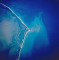
Hatteras Island
Encyclopedia
Barrier island
Barrier islands, a coastal landform and a type of barrier system, are relatively narrow strips of sand that parallel the mainland coast. They usually occur in chains, consisting of anything from a few islands to more than a dozen...
located off the North Carolina coast. Dividing the Atlantic Ocean
Atlantic Ocean
The Atlantic Ocean is the second-largest of the world's oceanic divisions. With a total area of about , it covers approximately 20% of the Earth's surface and about 26% of its water surface area...
and the Pamlico Sound
Pamlico Sound
Pamlico Sound in North Carolina, is the largest lagoon along the U.S. East Coast, being long and 24 to 48 km wide. It is a body of water separated from the Atlantic Ocean by the Outer Banks, a row of low, sandy barrier islands, including Cape Hatteras. The Neuse and Pamlico rivers flow in...
, it runs parallel to the coast, forming a bend at Cape Hatteras
Cape Hatteras
Cape Hatteras is a cape on the coast of North Carolina. It is the point that protrudes the farthest to the southeast along the northeast-to-southwest line of the Atlantic coast of North America...
. It is part of North Carolina's Outer Banks
Outer Banks
The Outer Banks is a 200-mile long string of narrow barrier islands off the coast of North Carolina, beginning in the southeastern corner of Virginia Beach on the east coast of the United States....
and includes the towns of Rodanthe
Rodanthe, North Carolina
Rodanthe is an unincorporated community located in Dare County, North Carolina, on Hatteras Island, part of North Carolina's Outer Banks. Rodanthe, along with Waves and Salvo, are part of the settlement of Chicamacomico...
, Waves
Waves, North Carolina
Waves is an unincorporated community in Dare County, North Carolina, USA. It is on Hatteras Island, part of North Carolina's Outer Banks. Waves, along with Rodanthe and Salvo, are part of the settlement of Chicamacomico....
, Salvo
Salvo, North Carolina
Salvo is an unincorporated community located in Dare County, North Carolina, on Hatteras Island, part of North Carolina's Outer Banks. Originally part of the settlement of Chicamacomico, Salvo was originally known as Clarks or Clarksville.The name "Salvo" allegedly stems from the American Civil...
, Avon
Avon, North Carolina
Avon is a a census-designated place in Dare County in the State of North Carolina in the United States of America. It is located at latitude 35°21'7" North, longitude 75°30'39" West. The village is south of Salvo and north of Buxton on Hatteras Island...
, Buxton
Buxton, North Carolina
Buxton is an unincorporated community of nearly 1,500 people on Hatteras Island near Cape Hatteras. It is located in Dare County in the U.S. state of North Carolina. North Carolina Highway 12 links the community to other Outer Banks communities such as Avon, Frisco, and Hatteras...
, Frisco
Frisco, North Carolina
Frisco is a small unincorporated community on the barrier island of Hatteras Island, between the villages of Buxton and Hatteras. It is located in Dare County, North Carolina, USA, and was previously named Trent, or Trent Woods, but received a new name with the coming of the post office in 1898...
, and Hatteras
Hatteras, North Carolina
Hatteras is an unincorporated community in Dare County, North Carolina, United States, on the Outer Banks island of Hatteras. North Carolina Highway 12 passes through the community linking it to Frisco and Ocracoke . It is south of the famous Cape Hatteras and the Cape Hatteras Lighthouse in Buxton...
. It contains the largest part of the Cape Hatteras National Seashore
Cape Hatteras National Seashore
Cape Hatteras National Seashore preserves the portion of the Outer Banks of North Carolina from Bodie Island to Ocracoke Island, stretching over . Included within this section of barrier islands along N.C...
. It is almost entirely in Dare County, North Carolina
Dare County, North Carolina
-National protected areas:* Alligator River National Wildlife Refuge * Cape Hatteras National Seashore * Fort Raleigh National Historic Site* Pea Island National Wildlife Refuge* Wright Brothers National Memorial-Demographics:...
, but there is a very small sliver of about 45 acres (182,108.7 m²) which extends southwest into Hyde County
Hyde County, North Carolina
-National protected areas:* Alligator River National Wildlife Refuge * Cape Hatteras National Seashore * Mattamuskeet National Wildlife Refuge* Pocosin Lakes National Wildlife Refuge * Swanquarter National Wildlife Refuge-Demographics:...
.
The island is one of the longest in the contiguous United States, measuring 42 miles (68 km) along a straight line from end to end, or roughly 50 miles (80 km) along the curve of the land.
Hatteras Island is known for sport fishing, surfing, windsurfing and kiteboarding, and is known as "The blue marlin
Blue marlin
Blue marlin may refer to:* Atlantic blue marlin, Makaira nigricans* Indo-Pacific blue marlin, Makaira mazara, whether or not it is a separate species from Makaira nigricans is currently debated* MV Blue Marlin, a heavy transport ship...
capital of the world."
Accommodations range from hotels and condos to luxurious oceanfront cottages. Hatteras Island is often used for destination weddings, family reunions, and special events.
According to the United States Census Bureau
United States Census Bureau
The United States Census Bureau is the government agency that is responsible for the United States Census. It also gathers other national demographic and economic data...
the island has a land area of 85.56 km² (33.04 sq mi) and a population of 4,001 as of the 2000 census
United States Census, 2000
The Twenty-second United States Census, known as Census 2000 and conducted by the Census Bureau, determined the resident population of the United States on April 1, 2000, to be 281,421,906, an increase of 13.2% over the 248,709,873 persons enumerated during the 1990 Census...
.
History
The colonists of the lost Roanoke ColonyRoanoke Colony
The Roanoke Colony on Roanoke Island in Dare County, present-day North Carolina, United States was a late 16th-century attempt to establish a permanent English settlement in what later became the Virginia Colony. The enterprise was financed and organized by Sir Walter Raleigh and carried out by...
may have relocated to Hatteras Island. When John White
John White (surveyor)
John White was an English artist, and an early pioneer of English efforts to settle the New World. He was among those who sailed with Richard Grenville to North Carolina in 1585, acting as artist and mapmaker to the expedition. During his time at Roanoke Island he made a number of watercolor...
returned to Roanoke on a re-supply mission, the settlement was found empty, the only clue being the word "Croatoan" carved into a post of the fort and "Cro" carved into a nearby tree. All the houses and fortifications had been dismantled, which meant their departure had not been hurried. Before he had left the colony, White had instructed them that if anything happened to them, they should carve a Maltese cross
Maltese cross
The Maltese cross, also known as the Amalfi cross, is identified as the symbol of an order of Christian warriors known as the Knights Hospitaller or Knights of Malta and through them came to be identified with the Mediterranean island of Malta and is one of the National symbols of Malta...
on a tree nearby, indicating that their disappearance had been forced. As there was no cross, White took this to mean they had moved to "Croatoan Island" (now known as Hatteras Island), but he was unable to conduct a search. A massive storm was brewing and his men refused to go any further. The next day, they left.
Law enforcement
As there are no incorporated places on Hatteras, the island is patrolled by the Dare County Sheriff's Office, North Carolina Highway Patrol, and the National Park ServiceNational Park Service
The National Park Service is the U.S. federal agency that manages all national parks, many national monuments, and other conservation and historical properties with various title designations...
.
Accessibility
Hatteras Island is accessible from the northern Outer Banks via the Herbert C. Bonner Bridge. Hatteras is reached from the south via the Ocracoke-Hatteras ferry. Presently there is no direct route linking Hatteras Island to the Hyde County mainland, resulting in a 2-3 hour commute around the Pamlico Sound.In 2011, Hurricane Irene
Hurricane Irene (2011)
Hurricane Irene was a large and powerful Atlantic hurricane that left extensive flood and wind damage along its path through the Caribbean, the United States East Coast and as far north as Atlantic Canada in 2011...
destroyed part of Highway 12 between Nags Head and Rodanthe. Until the construction of a temporary solution, the only way of accessing Hatteras Island was by ferry.