
Hurricane Fabian
Encyclopedia
Hurricane Fabian was a powerful Cape Verde-type hurricane
that hit Bermuda
in early September during the 2003 Atlantic hurricane season
. Fabian, the sixth named storm, fourth hurricane, and first major hurricane of the season, developed from a tropical wave
in the tropical Atlantic Ocean on August 25. It moved west-northwestward under the influence of the subtropical ridge
to its north, and steadily strengthened in an area of warm water temperatures
and light wind shear
. The hurricane attained a peak intensity of 145 mph (230 km/h) on September 1, and it slowly weakened as it turned northward. On September 5, Fabian made a direct hit on Bermuda
with wind speeds of over 120 mph (195 km/h). After passing the island, the hurricane turned to the northeast, and became extratropical on September 8.
Fabian was the strongest hurricane to hit Bermuda since Hurricane Arlene in 1963. It was both the most damaging and the first hurricane to cause a death on the island since 1926. The hurricane's powerful winds resulted in moderate damage and destroyed roofs throughout the island. A strong storm surge associated with the hurricane killed four people crossing a causeway
on Bermuda, temporarily closing the only link between two islands. The endangered Bermuda Petrel
, better known as the Cahow, was threatened by the hurricane, which destroyed ten nests, although volunteer work transported the species to a safer location. Strong swells resulted in damage in northern Puerto Rico
and the Dominican Republic
, and also caused four people to drown along the United States' Atlantic coast
. In all, Fabian caused around US300,000,000 in damage and eight deaths.
emerged off the coast of Africa. Tracking westward, the wave developed convection
over its center, and conducive conditions allowed it to develop
further. The system passed through the Cape Verde
islands later that day as convection steadily weakened. Early on August 27, convection again increased and consolidated near the center, and later that day the wave developed into Tropical Depression Ten while located 420 miles (675 km) west of the Cape Verde islands. Moving westward into an area of warm waters and low vertical shear, the depression steadily intensified, and was named Tropical Storm Fabian on August 28 as convection increased and banding features became more prominent.
Banding features and outflow continued to develop as a ring of convection formed around the center of Fabian, and on August 30, the storm intensified into a hurricane while gradually slowing its motion to the west-northwest. As banding features and outflow became better defined, an eye
developed in the center of the deepest convection. Fabian quickly strengthened
and attained major hurricane status late that day. Deep convection became very concentric
around the 11.5 mile (18.5 km) wide eye, and the hurricane reached winds of 125 mph (200 km/h) early on August 31. At this time, the deepest convection near the eye degraded in appearance, and Fabian temporarily stopped its strengthening trend. Later that day, the eye became distinct again within a perfectly round area of deep convection. Outflow continued to expand in all directions, and Fabian intensified into a Category 4 hurricane
late on August 31. Thunderstorm
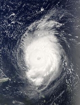
activity near the eyewall became more intense, and the cloud tops in the eyewall became much cooler; simultaneously, outflow away from the eye became much more symmetrical, both signs of an intensifying tropical cyclone. Fabian reached its peak intensity of 145 mph (230 km/h) on September 1 while located 345 miles (555 km) east of the northern Lesser Antilles
.
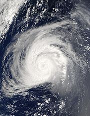 After maintaining its peak intensity for 12 hours Fabian degraded due to internal fluctuations, and began to weaken. The hurricane turned to the northwest on September 2 in response to a weakness in the subtropical ridge
, a break caused by a mid-level circulation over the southwest Atlantic Ocean. After fading back to a Category 3 hurricane, Fabian re-intensified on September 4, and regained Category 4 status for a short time. The hurricane weakened again as it accelerated northward towards Bermuda
, a motion due to an approaching mid-level trough
. As small pockets of dry air became entrained in the eyewall, Fabian weakened slightly, passing just 14 miles (23 km) west of Bermuda on September 5 as a 120 mph (180 km/h) Category 3 hurricane
.
The eastern portion of the eyewall moved over the island, resulting in a direct hit; however, as the center did not move over the island, Fabian did not make landfallCape Verde-type hurricane
A Cape Verde-type hurricane is an Atlantic hurricane that develops near the Cape Verde islands, off the west coast of Africa. The average hurricane season has about two Cape Verde-type hurricanes, which are usually the largest and most intense storms of the season because they often have plenty of...
that hit Bermuda
Bermuda
Bermuda is a British overseas territory in the North Atlantic Ocean. Located off the east coast of the United States, its nearest landmass is Cape Hatteras, North Carolina, about to the west-northwest. It is about south of Halifax, Nova Scotia, Canada, and northeast of Miami, Florida...
in early September during the 2003 Atlantic hurricane season
2003 Atlantic hurricane season
The 2003 Atlantic hurricane season was an active Atlantic hurricane season with tropical activity before and after the official bounds of the season – the first such occurrence in 50 years. The season produced 21 tropical cyclones, of which 16 developed into named storms; seven...
. Fabian, the sixth named storm, fourth hurricane, and first major hurricane of the season, developed from a tropical wave
Tropical wave
Tropical waves, easterly waves, or tropical easterly waves, also known as African easterly waves in the Atlantic region, are a type of atmospheric trough, an elongated area of relatively low air pressure, oriented north to south, which move from east to west across the tropics causing areas of...
in the tropical Atlantic Ocean on August 25. It moved west-northwestward under the influence of the subtropical ridge
Subtropical ridge
The subtropical ridge is a significant belt of high pressure situated around the latitudes of 30°N in the Northern Hemisphere and 30°S in the Southern Hemisphere. It is characterized by mostly calm winds, which acts to reduce air quality under its axis by causing fog overnight, and haze during...
to its north, and steadily strengthened in an area of warm water temperatures
Sea surface temperature
Sea surface temperature is the water temperature close to the oceans surface. The exact meaning of surface varies according to the measurement method used, but it is between and below the sea surface. Air masses in the Earth's atmosphere are highly modified by sea surface temperatures within a...
and light wind shear
Wind shear
Wind shear, sometimes referred to as windshear or wind gradient, is a difference in wind speed and direction over a relatively short distance in the atmosphere...
. The hurricane attained a peak intensity of 145 mph (230 km/h) on September 1, and it slowly weakened as it turned northward. On September 5, Fabian made a direct hit on Bermuda
Bermuda
Bermuda is a British overseas territory in the North Atlantic Ocean. Located off the east coast of the United States, its nearest landmass is Cape Hatteras, North Carolina, about to the west-northwest. It is about south of Halifax, Nova Scotia, Canada, and northeast of Miami, Florida...
with wind speeds of over 120 mph (195 km/h). After passing the island, the hurricane turned to the northeast, and became extratropical on September 8.
Fabian was the strongest hurricane to hit Bermuda since Hurricane Arlene in 1963. It was both the most damaging and the first hurricane to cause a death on the island since 1926. The hurricane's powerful winds resulted in moderate damage and destroyed roofs throughout the island. A strong storm surge associated with the hurricane killed four people crossing a causeway
The Causeway, Bermuda
The Causeway is a narrow strip of reclaimed land and bridges in the north of Bermuda linking Hamilton Parish on the mainland in the southwest and Bermuda International Airport on St. David's Island in St. George's Parish in the northeast, which are otherwise divided by Castle Harbour.The need for...
on Bermuda, temporarily closing the only link between two islands. The endangered Bermuda Petrel
Bermuda Petrel
The Bermuda Petrel, Pterodroma cahow, is a gadfly petrel. Commonly known in Bermuda as the Cahow, a name derived from its eerie cries, this nocturnal ground-nesting seabird is the national bird of Bermuda, and a symbol of hope for nature conservation. It was thought extinct for 330 years...
, better known as the Cahow, was threatened by the hurricane, which destroyed ten nests, although volunteer work transported the species to a safer location. Strong swells resulted in damage in northern Puerto Rico
Puerto Rico
Puerto Rico , officially the Commonwealth of Puerto Rico , is an unincorporated territory of the United States, located in the northeastern Caribbean, east of the Dominican Republic and west of both the United States Virgin Islands and the British Virgin Islands.Puerto Rico comprises an...
and the Dominican Republic
Dominican Republic
The Dominican Republic is a nation on the island of La Hispaniola, part of the Greater Antilles archipelago in the Caribbean region. The western third of the island is occupied by the nation of Haiti, making Hispaniola one of two Caribbean islands that are shared by two countries...
, and also caused four people to drown along the United States' Atlantic coast
Atlantic Coast
The Atlantic Coast is any coast fronting the Atlantic Ocean. The term differentiates the coasts of countries or continents with coastlines on more than one body of water, such as North America, South America, Africa and Europe.-See also:*Indian Ocean...
. In all, Fabian caused around US300,000,000 in damage and eight deaths.
Meteorological history
On August 25, a tropical waveTropical wave
Tropical waves, easterly waves, or tropical easterly waves, also known as African easterly waves in the Atlantic region, are a type of atmospheric trough, an elongated area of relatively low air pressure, oriented north to south, which move from east to west across the tropics causing areas of...
emerged off the coast of Africa. Tracking westward, the wave developed convection
Convection
Convection is the movement of molecules within fluids and rheids. It cannot take place in solids, since neither bulk current flows nor significant diffusion can take place in solids....
over its center, and conducive conditions allowed it to develop
Tropical cyclogenesis
Tropical cyclogenesis is the term that describes the development and strengthening of a tropical cyclone in the atmosphere. The mechanisms through which tropical cyclogenesis occurs are distinctly different from those through which mid-latitude cyclogenesis occurs...
further. The system passed through the Cape Verde
Cape Verde
The Republic of Cape Verde is an island country, spanning an archipelago of 10 islands located in the central Atlantic Ocean, 570 kilometres off the coast of Western Africa...
islands later that day as convection steadily weakened. Early on August 27, convection again increased and consolidated near the center, and later that day the wave developed into Tropical Depression Ten while located 420 miles (675 km) west of the Cape Verde islands. Moving westward into an area of warm waters and low vertical shear, the depression steadily intensified, and was named Tropical Storm Fabian on August 28 as convection increased and banding features became more prominent.
Banding features and outflow continued to develop as a ring of convection formed around the center of Fabian, and on August 30, the storm intensified into a hurricane while gradually slowing its motion to the west-northwest. As banding features and outflow became better defined, an eye
Eye (cyclone)
The eye is a region of mostly calm weather found at the center of strong tropical cyclones. The eye of a storm is a roughly circular area and typically 30–65 km in diameter. It is surrounded by the eyewall, a ring of towering thunderstorms where the second most severe weather of a cyclone...
developed in the center of the deepest convection. Fabian quickly strengthened
Rapid deepening
Rapid deepening, also known as rapid intensification, is a meteorological condition that occurs when the minimum sea-level atmospheric pressure of a tropical cyclone decreases drastically in a short period of time. The National Weather Service describes rapid deepening as a decrease of...
and attained major hurricane status late that day. Deep convection became very concentric
Concentric
Concentric objects share the same center, axis or origin with one inside the other. Circles, tubes, cylindrical shafts, disks, and spheres may be concentric to one another...
around the 11.5 mile (18.5 km) wide eye, and the hurricane reached winds of 125 mph (200 km/h) early on August 31. At this time, the deepest convection near the eye degraded in appearance, and Fabian temporarily stopped its strengthening trend. Later that day, the eye became distinct again within a perfectly round area of deep convection. Outflow continued to expand in all directions, and Fabian intensified into a Category 4 hurricane
Saffir-Simpson Hurricane Scale
The Saffir–Simpson Hurricane Scale , or the Saffir–Simpson Hurricane Wind Scale , classifies hurricanes — Western Hemisphere tropical cyclones that exceed the intensities of tropical depressions and tropical storms — into five categories distinguished by the intensities of their sustained winds...
late on August 31. Thunderstorm
Thunderstorm
A thunderstorm, also known as an electrical storm, a lightning storm, thundershower or simply a storm is a form of weather characterized by the presence of lightning and its acoustic effect on the Earth's atmosphere known as thunder. The meteorologically assigned cloud type associated with the...
activity near the eyewall became more intense, and the cloud tops in the eyewall became much cooler; simultaneously, outflow away from the eye became much more symmetrical, both signs of an intensifying tropical cyclone. Fabian reached its peak intensity of 145 mph (230 km/h) on September 1 while located 345 miles (555 km) east of the northern Lesser Antilles
Lesser Antilles
The Lesser Antilles are a long, partly volcanic island arc in the Western Hemisphere. Most of its islands form the eastern boundary of the Caribbean Sea with the Atlantic Ocean, with the remainder located in the southern Caribbean just north of South America...
.
Subtropical ridge
The subtropical ridge is a significant belt of high pressure situated around the latitudes of 30°N in the Northern Hemisphere and 30°S in the Southern Hemisphere. It is characterized by mostly calm winds, which acts to reduce air quality under its axis by causing fog overnight, and haze during...
, a break caused by a mid-level circulation over the southwest Atlantic Ocean. After fading back to a Category 3 hurricane, Fabian re-intensified on September 4, and regained Category 4 status for a short time. The hurricane weakened again as it accelerated northward towards Bermuda
Bermuda
Bermuda is a British overseas territory in the North Atlantic Ocean. Located off the east coast of the United States, its nearest landmass is Cape Hatteras, North Carolina, about to the west-northwest. It is about south of Halifax, Nova Scotia, Canada, and northeast of Miami, Florida...
, a motion due to an approaching mid-level trough
Trough (meteorology)
A trough is an elongated region of relatively low atmospheric pressure, often associated with fronts.Unlike fronts, there is not a universal symbol for a trough on a weather chart. The weather charts in some countries or regions mark troughs by a line. In the United States, a trough may be marked...
. As small pockets of dry air became entrained in the eyewall, Fabian weakened slightly, passing just 14 miles (23 km) west of Bermuda on September 5 as a 120 mph (180 km/h) Category 3 hurricane
Saffir-Simpson Hurricane Scale
The Saffir–Simpson Hurricane Scale , or the Saffir–Simpson Hurricane Wind Scale , classifies hurricanes — Western Hemisphere tropical cyclones that exceed the intensities of tropical depressions and tropical storms — into five categories distinguished by the intensities of their sustained winds...
.
Landfall (meteorology)
Landfall is the event of a tropical cyclone or a waterspout coming onto land after being over water. When a waterspout makes landfall it is reclassified as a tornado, which can then cause damage inland...
. After passing the island, the hurricane accelerated northeastward, and weakened to a 105 mph (170 km/h) Category 2 hurricane on September 7. Steady weakening occurred as the hurricane moved into an area of increasing wind shear, drier air, and progressively cooler waters. On September 8, while located 680 miles (1095 km) east-northeast of Cape Race
Cape Race
Cape Race is a point of land located at the southeastern tip of the Avalon Peninsula on the island of Newfoundland, Canada. Its name is thought to come from the original Portuguese name for this cape, "Raso", or "bare"...
, Newfoundland, Fabian transitioned into an extratropical storm
Extratropical cyclone
Extratropical cyclones, sometimes called mid-latitude cyclones or wave cyclones, are a group of cyclones defined as synoptic scale low pressure weather systems that occur in the middle latitudes of the Earth having neither tropical nor polar characteristics, and are connected with fronts and...
, with no deep convection remaining near the center. The extratropical remnant turned to the north on September 9, and on September 10 it merged with another extratropical storm while located between southern Greenland
Greenland
Greenland is an autonomous country within the Kingdom of Denmark, located between the Arctic and Atlantic Oceans, east of the Canadian Arctic Archipelago. Though physiographically a part of the continent of North America, Greenland has been politically and culturally associated with Europe for...
and Iceland
Iceland
Iceland , described as the Republic of Iceland, is a Nordic and European island country in the North Atlantic Ocean, on the Mid-Atlantic Ridge. Iceland also refers to the main island of the country, which contains almost all the population and almost all the land area. The country has a population...
.
Preparations
Several days prior to Fabian striking BermudaBermuda
Bermuda is a British overseas territory in the North Atlantic Ocean. Located off the east coast of the United States, its nearest landmass is Cape Hatteras, North Carolina, about to the west-northwest. It is about south of Halifax, Nova Scotia, Canada, and northeast of Miami, Florida...
, computer models
Tropical cyclone prediction model
A tropical cyclone forecast model is a computer program that uses meteorological data to forecast aspects of the future state of tropical cyclones. There are three types of models: statistical, dynamical, or combined statistical-dynamic...
forecast a ridge of high pressure
High pressure area
A high-pressure area is a region where the atmospheric pressure at the surface of the planet is greater than its surrounding environment. Winds within high-pressure areas flow outward due to the higher density air near their center and friction with land...
forcing the hurricane to the west of the island by 200 miles (320 km). Not expected to be a direct threat, a meteorologist at the Bermuda Weather Service expected gusty winds and potentially heavy rainfall. Each successive advisory brought the hurricane steadily closer to Bermuda, and 35 hours before Fabian made its closest approach, the Bermuda Weather Service issued a hurricane watch for the island. When a track near Bermuda became more certain, a hurricane warning was issued for the island, approximately 29 hours before Fabian made a direct hit on the island.
The Bermuda Electric Light Company recommended Bermuda residents to buy hurricane supplies such as candles, batteries, and non-perishable foods, to fill bathtubs and extra containers with water, and fill gasoline tanks for automobiles. In preparation, residents formed long lines at gas stations, banks, and supermarkets. All government offices and many businesses closed on the day prior to the hurricane hitting. All schools were closed, while all flights in and out of the island were canceled. Officials opened emergency shelter
Emergency shelter
Emergency shelters are places for people to live temporarily when they can't live in their previous residence, similar to homeless shelters. The main difference is that an emergency shelter typically specializes in people fleeing a specific type of situation, such as natural or man-made disasters,...
s, and recommended 2,000 low-lying residents to evacuate; a hotel on the south shore of the island was evacuated as well. Several cruise ships expected to remain on the island departed early to avoid the hurricane. Local insurance companies on Bermuda experienced a great increase in business, as residents renewed lapsed policies or signed up for new policies for homes or businesses, though marine policies were stopped several days before the hurricane struck. The arrival of Fabian forced the cancellation or delay of several sports events, including a cricket
Cricket
Cricket is a bat-and-ball game played between two teams of 11 players on an oval-shaped field, at the centre of which is a rectangular 22-yard long pitch. One team bats, trying to score as many runs as possible while the other team bowls and fields, trying to dismiss the batsmen and thus limit the...
match, a football
Football (soccer)
Association football, more commonly known as football or soccer, is a sport played between two teams of eleven players with a spherical ball...
game, and a dinghy
Dinghy
A dinghy is a type of small boat, often carried or towed for use as a ship's boat by a larger vessel. It is a loanword from either Bengali or Urdu. The term can also refer to small racing yachts or recreational open sailing boats. Utility dinghies are usually rowboats or have an outboard motor,...
race.
Impact
| Region | Direct deaths |
|---|---|
| Bermuda Bermuda Bermuda is a British overseas territory in the North Atlantic Ocean. Located off the east coast of the United States, its nearest landmass is Cape Hatteras, North Carolina, about to the west-northwest. It is about south of Halifax, Nova Scotia, Canada, and northeast of Miami, Florida... |
4 |
| Grand Banks Grand Banks The Grand Banks of Newfoundland are a group of underwater plateaus southeast of Newfoundland on the North American continental shelf. These areas are relatively shallow, ranging from in depth. The cold Labrador Current mixes with the warm waters of the Gulf Stream here.The mixing of these waters... |
3 |
| North Carolina North Carolina North Carolina is a state located in the southeastern United States. The state borders South Carolina and Georgia to the south, Tennessee to the west and Virginia to the north. North Carolina contains 100 counties. Its capital is Raleigh, and its largest city is Charlotte... |
1 |
| Total | 8 |
Throughout its path, Fabian killed 8 people and caused US300,000,000 in damages, primarily in Bermuda
Bermuda
Bermuda is a British overseas territory in the North Atlantic Ocean. Located off the east coast of the United States, its nearest landmass is Cape Hatteras, North Carolina, about to the west-northwest. It is about south of Halifax, Nova Scotia, Canada, and northeast of Miami, Florida...
.
Caribbean
The hurricane produced storm surge damage in AntiguaAntigua
Antigua , also known as Waladli, is an island in the West Indies, in the Leeward Islands in the Caribbean region, the main island of the country of Antigua and Barbuda. Antigua means "ancient" in Spanish and was named by Christopher Columbus after an icon in Seville Cathedral, Santa Maria de la...
and Barbuda
Barbuda
Barbuda is an island in the Eastern Caribbean, and forms part of the state of Antigua and Barbuda. It has a population of about 1,500, most of whom live in the town of Codrington.-Location:...
, where some boats were lightly damaged. Strong swells and high tides produced large waves on the north coast of Puerto Rico
Puerto Rico
Puerto Rico , officially the Commonwealth of Puerto Rico , is an unincorporated territory of the United States, located in the northeastern Caribbean, east of the Dominican Republic and west of both the United States Virgin Islands and the British Virgin Islands.Puerto Rico comprises an...
, washing out beaches in various locations. Waves knocked out a 10 ft (3 m) portion of a construction site in Ocean Park
Ocean Park, Puerto Rico
Ocean Park is an upscale beachfront community within the district of Santurce, San Juan, Puerto Rico.-Location:Ocean Park has a land area of and a resident population of 1,976 inhabitants according to the 2000 United States Census...
, resulting in US30,000 in damage. In the Dominican Republic
Dominican Republic
The Dominican Republic is a nation on the island of La Hispaniola, part of the Greater Antilles archipelago in the Caribbean region. The western third of the island is occupied by the nation of Haiti, making Hispaniola one of two Caribbean islands that are shared by two countries...
, the hurricane produced waves of up to 8 ft (2.4 m) in height. Due to the waves and gusty winds, boats were advised to stay at port. Several families had to be evacuated in Nagua
Nagua
Nagua is the capital of María Trinidad Sánchez province, in the northeastern Dominican Republic.A medium-sized town, Nagua's economy relies on the production of agricultural products, principally rice, coconuts, and cocoa bean...
when rough seas flooded their homes.
Bermuda

Storm surge
A storm surge is an offshore rise of water associated with a low pressure weather system, typically tropical cyclones and strong extratropical cyclones. Storm surges are caused primarily by high winds pushing on the ocean's surface. The wind causes the water to pile up higher than the ordinary sea...
exceeding 11 feet (3 m) in height. Due to its fast motion, rainfall totals rose to only 1.82 inches (46.2 mm). There were several unofficial reports of tornadoes as well. Strong rip current
Rip current
A rip current, commonly referred to by the misnomer rip tide, is a strong channel of water flowing seaward from near the shore, typically through the surf line. Typical flow is at 0.5 metres per second , and can be as fast as 2.5 metres per second...
s from the hurricane persisted for several days prior to Fabian passing the island; two swimmers were caught in the currents and relied on lifeguard
Lifeguard
A lifeguard supervises the safety and rescue of swimmers, surfers, and other water sports participants such as in a swimming pool, water park, or beach. Lifeguards are strong swimmers and trained in first aid, certified in water rescue using a variety of aids and equipment depending on...
assistance to return to shore. As a result, rip tide
Rip current
A rip current, commonly referred to by the misnomer rip tide, is a strong channel of water flowing seaward from near the shore, typically through the surf line. Typical flow is at 0.5 metres per second , and can be as fast as 2.5 metres per second...
warnings were posted for the island.
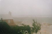
Strong waves caused extensive damage to the coastline, especially on the southern portion of Bermuda. The strong waves broke a boat from its moorings at Spanish Point
Spanish Point, Bermuda
Spanish Point is a prominent headland in Bermuda, located in Pembroke Parish five kilometres to the northwest of the capital Hamilton. It forms the eastern coast at the entrance to the Great Sound....
. Not wanting to lose the ship, the owner, accompanied with two people, tried to save the vessel. One fell overboard before climbing aboard the boat. The three ventured the vessel through tornadoes and 20-foot (6 m) waves, which dropped several feet of water in the ship; however, ultimately they safely arrived at Hamilton Harbour
Hamilton Harbour, Bermuda
Hamilton Harbour is a natural harbour in Bermuda which serves as the port for the capital, the City of Hamilton. It is an arm of the Great Sound, and forms a tapering wedge shape of water between Paget Parish and the peninsula which forms Pembroke Parish, and upon which the capital sits.The...
. Five charter boats capsized from the waves, while several others crashed against reefs. Strong waves collapsed a sea wall in Hamilton
Hamilton, Bermuda
Hamilton is the capital of the British Overseas Territory of Bermuda. It is the territory's financial centre and a major port and tourist destination.-Geography:...
, causing traffic jams for one day until it was fixed.
The winds downed numerous power lines, causing 78% of the island's 32,031 power customers to experience power outage
Power outage
A power outage is a short- or long-term loss of the electric power to an area.There are many causes of power failures in an electricity network...
s. The strong winds damaged or destroyed the roofs of numerous buildings on Bermuda. One of the areas lightest hit was around a hotel outside of Hamilton, which experienced no power outages or blown out windows, while one of the harder hit areas was Warwick
Warwick Parish, Bermuda
Warwick Parish is one of the nine parishes of Bermuda. It is named for Robert Rich, 2nd Earl of Warwick .It is located in the central south of the island chain, occupying part of the main island to the southeast of the Great Sound, the large expanse of water which dominates the geography of western...
. There, one resident noted, "Too many homes have lost roofs to count". One house was entirely destroyed on Rec View Hill, while an unconfirmed tornado destroyed much of the roof of a house in Devonshire
Devonshire Parish, Bermuda
-Location:It is located in the centre of the territory, close to the junction between the main part of the main island and the peninsula containing the capital, Hamilton, and Pembroke Parish . To the northeast, it is joined to Smith's Parish, and to the southwest it borders Paget Parish. As with...
. The hurricane destroyed a restaurant in Southampton
Southampton Parish, Bermuda
Southampton Parish is one of the nine parishes of Bermuda. It is named for Henry Wriothesley, 3rd Earl of Southampton .It is located in the southwest of the island chain, occupying all of the western part of the main island, except for the westernmost tip...
and also damaged stands and roofs at sports facilities. Strong winds from the hurricane damaged several landmark buildings, including the House of Assembly
House of Assembly of Bermuda
The House of Assembly is the lower house of the Parliament of Bermuda. The house has 36 members, each elected for a five year term in a single seat constituencies....
and the City Hall, both in Hamilton, and the former military headquarters in St. George's.
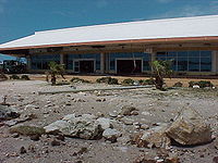
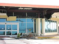
Bermuda International Airport
L.F. Wade International Airport , formerly named Bermuda International Airport, is the sole airport serving Bermuda, a British overseas territory in the North Atlantic Ocean. It is located in the parish of St. George's and is northeast of Bermuda's capital city of Hamilton. In 2006, L.F. Wade...
sustained $15 million in damages, primarily to buildings and roadways which were washed away by the storm surge. The runway escaped major damage, however, and the airport re-opened the following day for emergency relief flights. Commercial airline service was suspended for three days due to heavy damage to the Terminal Building, which was flooded with 3 ft (0.9144 m) of seawater. The airport's ILS
Instrument Landing System
An instrument landing system is a ground-based instrument approach system that provides precision guidance to an aircraft approaching and landing on a runway, using a combination of radio signals and, in many cases, high-intensity lighting arrays to enable a safe landing during instrument...
and radar were also damaged.
The hurricane also affected the Bermuda Weather Service, as 8 ft (2.4 m) waves destroyed recording equipment. The winds severely damaged the island's major hotels, closing five for extended periods to repair damage. One hotel that remained open experienced damage to 25% of its rooms. The strong winds uprooted hundreds of trees along the island's golf course
Golf course
A golf course comprises a series of holes, each consisting of a teeing ground, fairway, rough and other hazards, and a green with a flagstick and cup, all designed for the game of golf. A standard round of golf consists of playing 18 holes, thus most golf courses have this number of holes...
s, though little damage was reported at most courses. One course experienced significant damage at its club house, temporarily closing it.
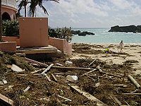
The strong winds blew down hundreds of trees, caused severe damage to vegetation, and destroyed many of the island's indigenous plants
Flora and fauna in Bermuda
The flora and fauna of Bermuda forms part of a unique ecosystem thanks to Bermuda's isolation from the mainland of North America. There are a wide range of endemic species and the islands form a distinct ecoregion, the Bermuda subtropical conifer forests....
. The hurricane washed away large sections of the nesting island for the endangered
Endangered species
An endangered species is a population of organisms which is at risk of becoming extinct because it is either few in numbers, or threatened by changing environmental or predation parameters...
Bermuda Petrel
Bermuda Petrel
The Bermuda Petrel, Pterodroma cahow, is a gadfly petrel. Commonly known in Bermuda as the Cahow, a name derived from its eerie cries, this nocturnal ground-nesting seabird is the national bird of Bermuda, and a symbol of hope for nature conservation. It was thought extinct for 330 years...
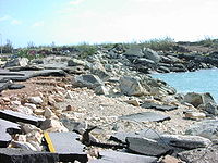
and destroyed 10 of the 70 active nests. The endangered birds were not on the island, though local residents quickly gathered to restore their habitat. Strong waves resulted in severe coastal erosion
Coastal erosion
Coastal erosion is the wearing away of land and the removal of beach or dune sediments by wave action, tidal currents, wave currents, or drainage...
, and at one beach, the lack of sand destroyed a natural cove. The Natural Arches, a set of eroded stones resembling an arch that was popular in photographs, was destroyed by the waves. The powerful winds knocked coconuts of off several trees and scattered them across the ground.
The storm surge from the hurricane stranded one vehicle with three police officers and another with a resident on the causeway
The Causeway, Bermuda
The Causeway is a narrow strip of reclaimed land and bridges in the north of Bermuda linking Hamilton Parish on the mainland in the southwest and Bermuda International Airport on St. David's Island in St. George's Parish in the northeast, which are otherwise divided by Castle Harbour.The need for...
between St. George's Parish
St. George's Parish, Bermuda
St. George's Parish is one of the nine parishes of Bermuda. It is named after the founder of the Bermuda colony, Admiral Sir George Somers.It is located in the north-easternmost part of the island chain, containing a small part of the main island around Tucker's Town and the Tucker's Town...
and St. David's Island
St. David's Island, Bermuda
St. David's Island is one of the main islands of Bermuda. It is located in the far north of the territory, one of the two similarly sized islands that makeup the majority of St...
. After a fire truck failed in its attempt to rescue them, powerful waves washed the vehicles into Castle Harbour
Castle Harbour, Bermuda
Castle Harbour is a large natural harbour in Bermuda. It is located between the northeastern end of the main island and St. David's Island. Originally called Southampton Port, it was renamed as a result of its heavy fortification in the early decades of the Seventeenth century.-Geography:A gem of...
. The United States Coast Guard
United States Coast Guard
The United States Coast Guard is a branch of the United States Armed Forces and one of the seven U.S. uniformed services. The Coast Guard is a maritime, military, multi-mission service unique among the military branches for having a maritime law enforcement mission and a federal regulatory agency...
and Bermuda police divers mounted a full-scale search for the missing people during the worst of the storm. The strong winds and emotional issues of searching for colleagues made the search difficult. Ultimately, the vehicles and one dead body were recovered, with the others remaining missing, presumably dead. Another vehicle was on the causeway as the two cars became stranded, though the driver was able to safely cross. High winds and surf tore off the causeway's side walls and greatly damaged the structure, temporarily closing it to automobile traffic.
As most people were well-prepared, these were the only four deaths on the island. In addition, nine people sought medical attention for minor injuries. Damage on Bermuda totaled to US300,000,000, reportedly the worst to affect the area since 1926.
Atlantic coast
Swells from the hurricane produced rip currents and heavy surf along the eastern North CarolinaNorth Carolina
North Carolina is a state located in the southeastern United States. The state borders South Carolina and Georgia to the south, Tennessee to the west and Virginia to the north. North Carolina contains 100 counties. Its capital is Raleigh, and its largest city is Charlotte...
coastline. One man drowned near Cape Hatteras from the rip currents. Fabian produced moderate surfing conditions along the East Coast of the United States
East Coast of the United States
The East Coast of the United States, also known as the Eastern Seaboard, refers to the easternmost coastal states in the United States, which touch the Atlantic Ocean and stretch up to Canada. The term includes the U.S...
, primarily from Georgia
Georgia (U.S. state)
Georgia is a state located in the southeastern United States. It was established in 1732, the last of the original Thirteen Colonies. The state is named after King George II of Great Britain. Georgia was the fourth state to ratify the United States Constitution, on January 2, 1788...
to North Carolina. Three deaths were reported in the north Atlantic when a ship, The Pacific Attitude, sank south of Newfoundland in the Grand Banks
Grand Banks
The Grand Banks of Newfoundland are a group of underwater plateaus southeast of Newfoundland on the North American continental shelf. These areas are relatively shallow, ranging from in depth. The cold Labrador Current mixes with the warm waters of the Gulf Stream here.The mixing of these waters...
due to strong waves of over 60 feet (20 m) in height.
Aftermath
Tropical Storm Henri (2003)
Tropical Storm Henri was weak a tropical storm that formed in the 2003 Atlantic hurricane season. The eighth storm of the season, Henri was one of six tropical cyclones to hit the United States in the year. Henri formed from a tropical wave in the Gulf of Mexico in early September, and crossed over...
resulted in thunderstorms and heavy rainfall; this hindered recovery efforts, but did not cause any reported damage. Lack of power caused interruptions to communications. While an emergency broadcast station was installed and tested prior the hurricane, the hurricane caused a problem to the system's back-up generator. The causeway
The Causeway, Bermuda
The Causeway is a narrow strip of reclaimed land and bridges in the north of Bermuda linking Hamilton Parish on the mainland in the southwest and Bermuda International Airport on St. David's Island in St. George's Parish in the northeast, which are otherwise divided by Castle Harbour.The need for...
in Bermuda remained closed for several days after the hurricane as road crews made temporary repairs. Upon being opened three days after the storm, traffic was limited to one lane of the original two. However, the causeway had to be closed in the event of rain, winds exceeding 30 mph (48 km/h), and at night. The bridge was fully repaired by early November 2003.
In the days after the storm, people provided assistance for each other, especially for the elderly. Three days after the storm, for example, a radio station DJ announced a name for an elderly person in need, and within minutes someone would call to provide for their needs. Residents cleared smaller roads from debris with chainsaw
Chainsaw
A chainsaw is a portable mechanical saw, powered by electricity, compressed air, hydraulic power, or most commonly a two-stroke engine...
s, which in turn helped the power companies to make repairs quickly. As a result of damage on their homes, dozens of people stayed in five shelters or undamaged hotels. Residents purchased large quantities of gasoline in the days after Fabian, some of whom bought over US$500 worth. Officials assured there was no shortage, but requested drivers to conserve gas. XL Capital Ltd.
XL Capital Ltd.
XL Group plc is a financial services company headquartered in Ireland with executive offices in Bermuda. The company has approximately 3600 employees and offices on Africa, Asia, Australia, Europe, North America and South America...
shipped 250 tarpaulin
Tarpaulin
A tarpaulin, colloquially tarp, is a large sheet of strong, flexible, water-resistant or waterproof material, often cloth such as canvas or polyester coated with urethane, or made of plastics such as polyethylene. In some places such as Australia, and in military slang, a tarp may be known as a...
s, 10 electric generators, and rope supply to the island. The UK government offered help to the island with two Royal Navy
Royal Navy
The Royal Navy is the naval warfare service branch of the British Armed Forces. Founded in the 16th century, it is the oldest service branch and is known as the Senior Service...
ships with supplies such as tents, dried foods, and blankets. Premier Alex Scott
William Alexander Scott
William Alexander "Alex" Scott JP, MP is a politician in Bermuda who is the MP for the Warwick South East constituency. Between 2003 and 2006 he served as the Premier of Bermuda and leader of the Progressive Labour Party ....
declined the offer, believing the island could withstand on its own. World Vision
World Vision
World Vision, founded in the USA in 1950, is an evangelical relief and development organization whose stated goal is "to follow our Lord and Saviour Jesus Christ in working with the poor and oppressed to promote human transformation, seek justice and bear witness to the good news of the Kingdom of...
also offered assistance with blankets, tents, and other supplies, while two United States companies offered to send generators. Bermuda Electric Light received aid from the Caribbean Electric Organization, which sent over 20 electricians to repair power lines.
South Carolina
South Carolina is a state in the Deep South of the United States that borders Georgia to the south, North Carolina to the north, and the Atlantic Ocean to the east. Originally part of the Province of Carolina, the Province of South Carolina was one of the 13 colonies that declared independence...
Maritime Heritage Foundation, with support from a Boy Scout troop and nearby nurseries, delivered 1,000 boxwood
Buxus
Buxus is a genus of about 70 species in the family Buxaceae. Common names include box or boxwood ....
plants to the island. Following the damage to the Bermuda Petrel's habitat, Bermuda's Department of Conservation carried out a translocation program, which involved moving the habitat to Nonsuch Island. That island, a long-standing nature preserve, was much higher and safer for the birds, and by two years after the hurricane the population numbers were higher than before the storm.
Shortly after the hurricane, the American home improvement franchise This Old House
This Old House
This Old House is an American home improvement magazine and television series aired on the American television station Public Broadcasting Service which follows remodeling projects of houses over a number of weeks.-Overview:...
, unaware of the limited extent of damage, decided to do a hurricane repair story. Upon realising that there would be little to nothing available for the Ask This Old House to repair, it was decided instead to do a renovation of an 1805 home in St. George's
St. George's, Bermuda
St. George's , located on the island and within the parish of the same names, was the first permanent settlement on the islands of Bermuda, and is often described as the third successful English settlement in the Americas, after St. John's, Newfoundland, and Jamestown, Virginia. However, St...
. It was only the second time that the franchise had worked outside of the United States.
Retirement
Due to the damage and deaths on BermudaBermuda
Bermuda is a British overseas territory in the North Atlantic Ocean. Located off the east coast of the United States, its nearest landmass is Cape Hatteras, North Carolina, about to the west-northwest. It is about south of Halifax, Nova Scotia, Canada, and northeast of Miami, Florida...
, the name Fabian was retired in the spring of 2004 and will never again be used for an Atlantic hurricane. As a result, the Bermuda Weather Service allowed residents to suggest a replacement name, with the only rule being the name had to be a male name beginning with the letter "F", able to be easily pronounced, and not currently in use. The service received a list of over 30 names, including Forrest and Frodo, after the character
Frodo Baggins
Frodo Baggins is a fictional character in J. R. R. Tolkien's legendarium.He is the main protagonist of Tolkien's The Lord of the Rings. He was a hobbit of the Shire who inherited Sauron's Ring from Bilbo Baggins and undertook the quest to destroy it in the fires of Mount Doom...
in The Lord of the Rings
The Lord of the Rings
The Lord of the Rings is a high fantasy epic written by English philologist and University of Oxford professor J. R. R. Tolkien. The story began as a sequel to Tolkien's earlier, less complex children's fantasy novel The Hobbit , but eventually developed into a much larger work. It was written in...
. The Bermuda Weather Service sent three names to the World Meteorological Organization
World Meteorological Organization
The World Meteorological Organization is an intergovernmental organization with a membership of 189 Member States and Territories. It originated from the International Meteorological Organization , which was founded in 1873...
; Fred, Ford, and Flynn. The World Meteorological Organization ultimately replaced Fabian with Fred to be on the list for the 2009 season
2009 Atlantic hurricane season
The 2009 Atlantic hurricane season was a below-average year, unlike the 2009 Pacific hurricane season, which was above average, both due to a moderate El Niño. During this year, nine tropical storms formed, the fewest since the 1997 season.An average season has ten tropical storms, six hurricanes...
. Fabian is one of only two hurricanes to have its name retired without making landfall anywhere, the other being Klaus
Hurricane Klaus
Hurricane Klaus was a minimal Atlantic hurricane that dropped heavy rainfall across the Lesser Antilles in October 1990. The eleventh tropical cyclone and sixth hurricane of the 1990 Atlantic hurricane season, Klaus developed from a tropical wave on October 3 a short distance east of Dominica. It...
in 1990
1990 Atlantic hurricane season
The 1990 Atlantic hurricane season was the most active Atlantic hurricane season since 1969. It officially began on June 1, 1990, and lasted until November 30, 1990. These dates conventionally delimit the period of each year when most tropical cyclones form in the Atlantic basin...
.
See also
- List of retired Atlantic hurricane names
- List of Category 4 Atlantic hurricanes
External links
- NHC's archive on Hurricane Fabian
- NHC's Tropical Cyclone Report on Hurricane Fabian
- Wikimedia Commons Image Gallery on Hurricane Fabian