
.gif)
Highway 17 (Ontario)
Encyclopedia
King's Highway 17, more commonly known as Highway 17, is a provincially maintained highway and the primary route of the Trans-Canada Highway
through the Canadian
province of Ontario
. It begins at the Manitoba
border 50 km (31.1 mi) west of Kenora and ends south of Arnprior
at the western terminus of Highway 417, 1964 km (1,220.4 mi) to the east. This makes it Ontario's longest highway.See List of highways in Ontario for length comparisons.
The highway once extended even farther to the Quebec
border in East Hawkesbury
with a peak length of about 2180 km (1,354.6 mi). However, a section of Highway 17 "disappeared" when the Ottawa section of it was upgraded to the freeway Highway 417 in 1971. Highway 17 was not re-routed through Ottawa, nor did it share numbering with Highway 417 to rectify the discontinuity, even though Highway 417 formed a direct link between the western and eastern sections of Highway 17. However, from East Hawkesbury to Ottawa, Highway 17 retained the Trans-Canada Highway routing and signs until it met up again and merged with Highway 417 until 1997, when Highway 17 through Ottawa was downloaded. The Trans-Canada Highway designation now extends along all of Highway 417.
at the Ontario–Quebec border. Both these routes became known as Highway 17 in the summer of 1925.
By 1930, a road existed between Pembroke and Sault Saint Marie, although it was not part of Highway 17 at the time.
This road was constructed beginning in 1926 with the signing of the Department of Northern Development (DND) Act. On April 1, 1937, the DND was absorbed into the Department of Highways, and the road west of Pembroke became an extension of Highway 17.
The portion of Highway 17 over the top of Lake Superior was constructed in the late 1950s as a result of the Trans-Canada Highway Act. Amongst some of the most difficult terrain encountered in Canada, engineers blasted 2,730,000 cubic yards of rock, removed 7,825,000 cubic yards of earth, and cleared 6.97 square kilometres (1,722.3 acre) of forest in order to bridge the 266 kilometres (165.3 mi) of wilderness known as "the Gap". The Gap was completed and opened to traffic on September 17, 1960, uniting the two segments and completing the route of Highway 17 from the Manitoba border to the Quebec border.
The last gravel stretch of Hwy 17 was located west of Ignace
and was paved in 1967.
During the 1950s, the Greber Plan
in Ottawa called for the creation of numerous parkways and divided highways through the burgeoning city. One of these, known as The Queensway, was a grade-separated freeway that would bypass Highway 17. This freeway was gradually constructed throughout the 1960s.
On April 1, 1997, the Ministry of Transportation of Ontario (MTO) transferred the responsibility of maintenance and upkeep along 14.2 km (8.8 mi) of Highway 17 east of "the split" with Ontario Highway 417 to Trim Road (Regional Road 57), a process commonly referred to as downloading. The Region of Ottawa–Carleton designated the road as Regional Road 174
. Despite the protests of the region that the road served a provincial purpose, a second round of transfers saw Highway 17 within Ottawa downloaded entirely on January 1, 1998. An additional 12.8 km (8 mi) was added to the length of Regional Road 174.
Highway 17 was also downloaded within the United Counties of Prescott and Russell, where it was redesignated as County Road 17.
; further west into Manitoba the highway widens into a four lane divided expressway. To the east, the highway travels through thick boreal forest towards Keewatin, where the grade-separated Kenora Bypass, Highway 17A, splits to the north. Through the town of Kenora, Highway 17 is signed, but maintained under a connecting link
agreement between the town and the province. Full provincial maintenance resumes at the eastern town limits. Further east, the highway merges with the Kenora Bypass. It meets the northern terminus of Highway 71, then makes a gradual eastward journey through the lake-dotted Kenora District to the town of Dryden
. Here the highway encounters one of the few agriculturally-sustainable areas of northern Ontario
. The highway begins to zig-zag southeasterly, passing through several minor settlements before entering the mining town of Ignace
. Shortly thereafter, it begins to curve to the south. It meets Highway 11 475 km (295.2 mi) east of the Manitoba border.
The two highways travel concurrently
towards Thunder Bay
at the western lakehead of Lake Superior
. Though it originally travelled through what was then the twin-cities, the highway bypasses
to the northwest on the at-grade Thunder Bay Expressway
.
. Along with the railway crossing immediately to the south, and another on the northern shore of Lake Nipigon
, this forms the narrowest bottleneck
in Canada between the Atlantic and Pacific oceans. On the eastern shore of the river, Highway 11 separates and travels north towards Geraldton and Hearst
. Highway 17 continues east along the northern shore of Lake Superior. Near White River
, the highway enters Algoma District and turns southward. It meets the western terminus of Highway 101 near Wawa
, which provides for a shorter route to Sudbury via the Sultan Industrial Road
.
 South of Wawa, the highway enters Lake Superior Provincial Park
. After proceeding through several mountain ranges, and crossing numerous rivers, the highway enters Sault Ste. Marie
. Here a border crossing into the United States is provided via the Sault Ste. Marie International Bridge
, which connects with I-75
in Michigan
. As the highway exits Sault Ste. Marie to the east, a newly constructed segment of four lane divided highway branches north; Highway 17B (the only remaining business route of Highway 17 in service) continues east through Garden River. The divided highway bypasses Garden River and passes east of Echo Bay before curving south and merging with Highway 17B.
Shortly thereafter, it turns to the east and travels along the North Channel
of Lake Huron
towards Sudbury, passing through numerous small towns, including Thessalon
, Blind River
, Massey and McKerrow. At Sudbury, the highway widens into a freeway through the Walden
area of the city until reaching the Southwest / Southeast Bypass
at Lively, where it narrows again to a Super 2
road. This segment is currently undergoing an environmental assessment, with plans to upgrade it to a full freeway in the next ten years.
 Highway 17 passes to the south of the urban centre of Sudbury. It meets Highway 69
at an interchange
; with the conversion of Highway 69 to Highway 400 underway, through-traffic will be transferred to a new interchange several kilometres further north, while the existing alignment of Highway 69 will become an extension of Municipal Road 46. At this interchange, the Southwest and Southeast Bypasses meet, and for just over a kilometre, Highway 17 is a divided four-laned freeway.
The Super 2 continues northeast to meet the original alignment of Highway 17 east of downtown Sudbury. Here it turns east and travels through the city's outlying neighbourhoods of Coniston and Wahnapitae; a new freeway alignment of this route is currently in the planning stages.
The highway route passes through the rural municipalities of Markstay-Warren and West Nipissing before reaching North Bay
, where it follows an undivided four-lane expressway
alignment, with reduced but not full control of access, through the city of North Bay. For 4.1 kilometres from Algonquin Avenue to the Twin Lakes area, the route is once again concurrent with Highway 11. At the northern end of this concurrency, Highway 11 travels north and wraps westward and south to Nipigon; at the southern end, it continues southward towards Toronto
, while Highway 17 turns east toward the Ottawa Valley
. An at-grade
intersection with Highway 63 is located at approximately the midpoint of the concurrency.
 East of North Bay, Highway 17 meets Highway 94, the last connection into southern Ontario
for nearly 200 km (124.3 mi), thereafter travelling alongside the Mattawa River
to its confluence
with the Ottawa River
in Mattawa
, where drivers must turn at a junction with Highway 533. The highway then parallels the Ottawa River through a mountainous region, first passing through the villages of Stonecliffe and Rolphton before arriving in Deep River
, a planned community
developed as part of the Manhattan Project
. It then passes through Chalk River
and enters Canadian Forces Base Petawawa.
Beginning at the southern end of the army base, Highway 17 follows the Pembroke Bypass, bypassing west of Petawawa and Pembroke
, where it intersects Highway 41. The bypass ends at Renfrew County Road 40, north of Muskrat Lake
. The highway then travels south through the town of Cobden
. It follows a bypass east of Renfrew
and meets Highway 60. Highway 17 curves east and travels towards Arnprior
, which the highway bypasses south of. After crossing the Madawaska River
, the highway divides and widens to four lanes, at which point Highway 17 ends and Highway 417 begins.

s, all but one of which have been decommissioned. All were at one time the primary route of Highway 17 through their respective locations, and were given the business route designation following the construction or designation of a newer bypass
alignment.
Sault Ste. Marie
MPP David Orazietti
has spearheaded a petition to have the entire highway four-laned from Arnprior to Sault Ste. Marie, similar to the campaign previously undertaken by his caucus colleague Rick Bartolucci
regarding the extension of Highway 400. Cheryl Gallant
, the federal Member of Parliament for Renfrew—Nipissing—Pembroke
, has also advocated for the four-laning of the highway through the Ottawa Valley
toward North Bay
, and ultimately the entire length of the highway throughout Northern Ontario
.
A 2009 study commissioned by the forestry trade magazine The Working Forest, titled "A Vision for Ontario’s Trans Canada Highway, North Bay to the Manitoba Border", determined that it would cost the Ontario government $600 million per year over 25 years to convert the entire length of both Highway 17 and Highway 11 to freeway, suggesting that a comprehensive plan would be affordable and achievable if the provincial and federal governments could reach a cost-sharing agreement.
 Studies are underway on the extension of Highway 417 through the Ottawa Valley
region from its current terminus at Arnprior
to Petawawa
. From Arnprior to Haley Station and from Meath to Petawawa, the proposed freeway route largely follows the existing alignment — in these areas, the current highway route largely avoids existing communities, and thus a second set of lanes can be easily added alongside the existing route. Within the township of Whitewater Region
, however, a new alignment is planned several kilometres east of the existing road in order to bypass communities such as Cobden
.
, and further studies on the routes from Bonfield to Mattawa
and from North Bay to Cache Bay are expected to begin later in 2011 or 2012.
A new three level interchange will be constructed between Highway 17 and the future Highway 400 near the Lake Laurentian Conservation Area
.
Preliminary route planning studies have also been completed on the freeway's westerly extension to McKerrow, near Espanola
, but no construction schedule has been announced to date. However, the first phase of this route, extending the existing freeway from Municipal Road 55
in Sudbury for six kilometres further west through the Den-Lou
neighbourhood, is currently in the detail design phase.
, the expressway segment currently ends six kilometres short of its eventual terminus at Black Road and Second Line, as an agreement has yet to be reached with the Batchawana First Nation regarding land use through Rankin
. Completion of the segment is not currently expected until at least 2015. In the interim, highway traffic travels between the expressway and the current highway alignment through Sault Ste. Marie by means of the previously planned northerly extension of Trunk Road.
The former segment of Highway 17 through Garden River
was initially redesignated as part of Highway 638, although the Garden River First Nation disputed this designation and insisted that the highway be renamed Highway 17B. As of February 2009, the former route is now designated as Highway 17B. In February 2010, Garden River's band council publicly warned that they would consider imposing tolls
on the routes of both Highway 17 and Highway 17B through their territory if the provincial government did not assist the council with a funding shortfall of approximately $1 million.
In February 2011, the Ministry of Transportation announced that the expressway's current level intersection at Highway 638 in Echo Bay will be upgraded to a full interchange.
, from the Thunder Bay Expressway
to Vibert Road, intended to serve as a new alignment for Highways 11 and 17.
In July 2008 the federal and provincial governments announced a $6.2 billion infrastructure program that makes the four-laning of Hwys. 11 and 17 near Kenora and Thunder Bay a priority. Engineering work on twinning 11/17 between Nipigon
and Thunder Bay is to begin in 2008. On May 1, 2009 the federal and provincial government announced that twinning of Highway 11/17 would begin in 2010.
On May 15, 2009 the federal and provincial government also announced that twinning of Highway 17 at the Manitoba/Ontario border easterly toward Kenora would also begin in 2010.
Trans-Canada Highway
The Trans-Canada Highway is a federal-provincial highway system that joins the ten provinces of Canada. It is, along with the Trans-Siberian Highway and Australia's Highway 1, one of the world's longest national highways, with the main route spanning 8,030 km...
through the Canadian
Canada
Canada is a North American country consisting of ten provinces and three territories. Located in the northern part of the continent, it extends from the Atlantic Ocean in the east to the Pacific Ocean in the west, and northward into the Arctic Ocean...
province of Ontario
Ontario
Ontario is a province of Canada, located in east-central Canada. It is Canada's most populous province and second largest in total area. It is home to the nation's most populous city, Toronto, and the nation's capital, Ottawa....
. It begins at the Manitoba
Manitoba
Manitoba is a Canadian prairie province with an area of . The province has over 110,000 lakes and has a largely continental climate because of its flat topography. Agriculture, mostly concentrated in the fertile southern and western parts of the province, is vital to the province's economy; other...
border 50 km (31.1 mi) west of Kenora and ends south of Arnprior
Arnprior, Ontario
Arnprior is a town in Renfrew County, in the eastern portion of Southern Ontario, Canada. It is located at the mouth of the Madawaska River, as it enters the Ottawa River in the Ottawa Valley...
at the western terminus of Highway 417, 1964 km (1,220.4 mi) to the east. This makes it Ontario's longest highway.See List of highways in Ontario for length comparisons.
The highway once extended even farther to the Quebec
Quebec
Quebec or is a province in east-central Canada. It is the only Canadian province with a predominantly French-speaking population and the only one whose sole official language is French at the provincial level....
border in East Hawkesbury
East Hawkesbury, Ontario
East Hawkesbury is a township in eastern Ontario, Canada in the United Counties of Prescott and Russell. It is on the Ottawa River. Its eastern boundary is the border with the province of Quebec.-Communities:...
with a peak length of about 2180 km (1,354.6 mi). However, a section of Highway 17 "disappeared" when the Ottawa section of it was upgraded to the freeway Highway 417 in 1971. Highway 17 was not re-routed through Ottawa, nor did it share numbering with Highway 417 to rectify the discontinuity, even though Highway 417 formed a direct link between the western and eastern sections of Highway 17. However, from East Hawkesbury to Ottawa, Highway 17 retained the Trans-Canada Highway routing and signs until it met up again and merged with Highway 417 until 1997, when Highway 17 through Ottawa was downloaded. The Trans-Canada Highway designation now extends along all of Highway 417.
History
The route which would become Highway 17 was first designated as a provincial highway on February 26, 1920, when two separate highways were added to the system. The first travelled between Ottawa and Pembroke, while the second travelled between Ottawa and Point FortunePointe-Fortune, Quebec
Pointe-Fortune is a village in southwestern Quebec on the Ottawa River in Vaudreuil-Soulanges northwest of Montreal. The population as of the Canada 2006 Census was 507.-Population:Population trend-Language:...
at the Ontario–Quebec border. Both these routes became known as Highway 17 in the summer of 1925.
By 1930, a road existed between Pembroke and Sault Saint Marie, although it was not part of Highway 17 at the time.
This road was constructed beginning in 1926 with the signing of the Department of Northern Development (DND) Act. On April 1, 1937, the DND was absorbed into the Department of Highways, and the road west of Pembroke became an extension of Highway 17.
The portion of Highway 17 over the top of Lake Superior was constructed in the late 1950s as a result of the Trans-Canada Highway Act. Amongst some of the most difficult terrain encountered in Canada, engineers blasted 2,730,000 cubic yards of rock, removed 7,825,000 cubic yards of earth, and cleared 6.97 square kilometres (1,722.3 acre) of forest in order to bridge the 266 kilometres (165.3 mi) of wilderness known as "the Gap". The Gap was completed and opened to traffic on September 17, 1960, uniting the two segments and completing the route of Highway 17 from the Manitoba border to the Quebec border.
The last gravel stretch of Hwy 17 was located west of Ignace
Ignace, Ontario
Ignace is a township in the Kenora District of Northwestern Ontario, Canada, located at Highway 17 and Secondary Highway 599, and on the Canadian Pacific Railway between Thunder Bay and Kenora. It is on the shore of Agimak Lake, and, as of 2006, the population of Ignace was 1,431.The town was...
and was paved in 1967.
During the 1950s, the Greber Plan
Greber Plan
The Greber Plan, or General Report on the Plan for the National Capital , was an urban plan developed in 1950 by Jacques Gréber for the Federal District Commission of Ottawa, Ontario, Canada.Its main components were:...
in Ottawa called for the creation of numerous parkways and divided highways through the burgeoning city. One of these, known as The Queensway, was a grade-separated freeway that would bypass Highway 17. This freeway was gradually constructed throughout the 1960s.
On April 1, 1997, the Ministry of Transportation of Ontario (MTO) transferred the responsibility of maintenance and upkeep along 14.2 km (8.8 mi) of Highway 17 east of "the split" with Ontario Highway 417 to Trim Road (Regional Road 57), a process commonly referred to as downloading. The Region of Ottawa–Carleton designated the road as Regional Road 174
Regional Road 174
Ottawa Regional Road 174, commonly referred to as Highway 174, is a regionally maintained road in the city of Ottawa which serves the eastern suburbs of Orléans and Cumberland. Although the road continues through the towns of Rockland and Hawkesbury to the Quebec border, the portion east of the...
. Despite the protests of the region that the road served a provincial purpose, a second round of transfers saw Highway 17 within Ottawa downloaded entirely on January 1, 1998. An additional 12.8 km (8 mi) was added to the length of Regional Road 174.
Highway 17 was also downloaded within the United Counties of Prescott and Russell, where it was redesignated as County Road 17.
Route description
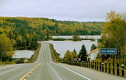
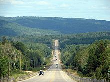
Highway 17 crosses some of the most remote regions of Ontario. Although there are several settlements established throughout its length, the distance between gas stations can often exceed several hundred kilometres. Despite the isolation of the highway, it is well-travelled throughout its length. The section of Highway 17 north of Lake Superior is regarded as one of the most scenic drives in the province.Manitoba to Nipigon
Highway 17 begins at the border between Ontario and Manitoba, where a large installation greets drivers in both directions. The highway is two lanes wide and travels over and between the surface features of the Canadian ShieldCanadian Shield
The Canadian Shield, also called the Laurentian Plateau, or Bouclier Canadien , is a vast geological shield covered by a thin layer of soil that forms the nucleus of the North American or Laurentia craton. It is an area mostly composed of igneous rock which relates to its long volcanic history...
; further west into Manitoba the highway widens into a four lane divided expressway. To the east, the highway travels through thick boreal forest towards Keewatin, where the grade-separated Kenora Bypass, Highway 17A, splits to the north. Through the town of Kenora, Highway 17 is signed, but maintained under a connecting link
Connecting Link
The Connecting Link program is a provincial subsidy provided to municipalities to assist with road construction, maintenance and repairs in the Canadian province of Ontario. Roads which are designated as connecting links form the portions of provincial highways through built-up communities which...
agreement between the town and the province. Full provincial maintenance resumes at the eastern town limits. Further east, the highway merges with the Kenora Bypass. It meets the northern terminus of Highway 71, then makes a gradual eastward journey through the lake-dotted Kenora District to the town of Dryden
Dryden, Ontario
Dryden is the second-largest city in the Kenora District of Northwestern Ontario, Canada, located on Wabigoon Lake. It is the smallest community in the province of Ontario designated as a city...
. Here the highway encounters one of the few agriculturally-sustainable areas of northern Ontario
Northern Ontario
Northern Ontario is a region of the Canadian province of Ontario which lies north of Lake Huron , the French River and Lake Nipissing. The region has a land area of 802,000 km2 and constitutes 87% of the land area of Ontario, although it contains only about 6% of the population...
. The highway begins to zig-zag southeasterly, passing through several minor settlements before entering the mining town of Ignace
Ignace, Ontario
Ignace is a township in the Kenora District of Northwestern Ontario, Canada, located at Highway 17 and Secondary Highway 599, and on the Canadian Pacific Railway between Thunder Bay and Kenora. It is on the shore of Agimak Lake, and, as of 2006, the population of Ignace was 1,431.The town was...
. Shortly thereafter, it begins to curve to the south. It meets Highway 11 475 km (295.2 mi) east of the Manitoba border.
The two highways travel concurrently
Concurrency (road)
A concurrency, overlap, or coincidence in a road network is an instance of one physical road bearing two or more different highway, motorway, or other route numbers...
towards Thunder Bay
Thunder Bay
-In Canada:Thunder Bay is the name of three places in the province of Ontario, Canada along Lake Superior:*Thunder Bay District, Ontario, a district in Northwestern Ontario*Thunder Bay, a city in Thunder Bay District*Thunder Bay, Unorganized, Ontario...
at the western lakehead of Lake Superior
Lake Superior
Lake Superior is the largest of the five traditionally-demarcated Great Lakes of North America. It is bounded to the north by the Canadian province of Ontario and the U.S. state of Minnesota, and to the south by the U.S. states of Wisconsin and Michigan. It is the largest freshwater lake in the...
. Though it originally travelled through what was then the twin-cities, the highway bypasses
Bypass (road)
A bypass is a road or highway that avoids or "bypasses" a built-up area, town, or village, to let through traffic flow without interference from local traffic, to reduce congestion in the built-up area, and to improve road safety....
to the northwest on the at-grade Thunder Bay Expressway
Thunder Bay Expressway
The Thunder Bay Expressway is a four lane highway with signalized intersections running on the western edge of Thunder Bay, Ontario, Canada.- Route description :...
.
Nipigon to Sudbury
Within Nipigon, Highway 11 and Highway 17 cross the Nipigon RiverNipigon River
The Nipigon River is about long and 50 to 200 m wide in Ontario, Canada. The river drains Lake Nipigon into Nipigon Bay in Lake Superior, dropping from an elevation of 260 m to 183 m .-History:...
. Along with the railway crossing immediately to the south, and another on the northern shore of Lake Nipigon
Lake Nipigon
Lake Nipigon is the largest lake entirely within the boundaries of the Canadian province of Ontario . It is sometimes described as the sixth Great Lake. Lying 260 metres above sea level, the lake drains into the Nipigon River and thence into Nipigon Bay of Lake Superior...
, this forms the narrowest bottleneck
Bottleneck
A bottleneck is a phenomenon where the performance or capacity of an entire system is limited by a single or limited number of components or resources. The term bottleneck is taken from the 'assets are water' metaphor. As water is poured out of a bottle, the rate of outflow is limited by the width...
in Canada between the Atlantic and Pacific oceans. On the eastern shore of the river, Highway 11 separates and travels north towards Geraldton and Hearst
Hearst, Ontario
Hearst is a town in the Canadian province of Ontario. It is located in Northern Ontario, approximately west of Kapuskasing, approximately north of Toronto and east of Thunder Bay on Highway 11...
. Highway 17 continues east along the northern shore of Lake Superior. Near White River
White River, Ontario
White River is a township located in Ontario, Canada, on the intersection of Highway 17 and Highway 631. It was originally set up as a rail town on the Canadian Pacific Railway in 1885...
, the highway enters Algoma District and turns southward. It meets the western terminus of Highway 101 near Wawa
Wawa, Ontario
Wawa is a township in the Canadian province of Ontario, located within the Algoma District. Formerly known as the township of Michipicoten, the township was officially renamed for its largest and best-known community in 2009....
, which provides for a shorter route to Sudbury via the Sultan Industrial Road
Sultan Industrial Road
The Sultan Industrial Road is a private road in the Canadian province of Ontario. Originally built as a resource route for E. B. Eddy's logging and lumber operations in the northwestern Sudbury District, the road is now owned and operated by Domtar following its acquisition of E. B. Eddy in 1998...
.
Lake Superior Provincial Park
Lake Superior Provincial Park is one of the largest provincial parks in Ontario, covering about along the northeastern shores of Lake Superior between Wawa and Sault Ste. Marie in Algoma District, Northeastern Ontario, Canada...
. After proceeding through several mountain ranges, and crossing numerous rivers, the highway enters Sault Ste. Marie
Sault Ste. Marie, Ontario
Sault Ste. Marie is a city on the St. Marys River in Algoma District, Ontario, Canada. It is the third largest city in Northern Ontario, after Sudbury and Thunder Bay, with a population of 74,948. The community was founded as a French religious mission: Sault either means "jump" or "rapids" in...
. Here a border crossing into the United States is provided via the Sault Ste. Marie International Bridge
Sault Ste. Marie International Bridge
The Sault Ste. Marie International Bridge, often known just as the International Bridge, spans the St. Marys River between the United States and Canada connecting the twin cities of Sault Ste. Marie, Michigan and Sault Ste. Marie, Ontario. It serves as the northern terminus of Interstate 75...
, which connects with I-75
Interstate 75 in Michigan
Interstate 75 is a part of the Interstate Highway System and runs from Miami, Florida to Sault Ste. Marie in the Upper Peninsula of Michigan. I-75 enters the state from Ohio in the south, just to the north of Toledo. It runs generally north through Detroit, Pontiac and Bay City, crossing the...
in Michigan
Michigan
Michigan is a U.S. state located in the Great Lakes Region of the United States of America. The name Michigan is the French form of the Ojibwa word mishigamaa, meaning "large water" or "large lake"....
. As the highway exits Sault Ste. Marie to the east, a newly constructed segment of four lane divided highway branches north; Highway 17B (the only remaining business route of Highway 17 in service) continues east through Garden River. The divided highway bypasses Garden River and passes east of Echo Bay before curving south and merging with Highway 17B.
Shortly thereafter, it turns to the east and travels along the North Channel
North Channel (Ontario)
The North Channel is the body of water along the north shore of Lake Huron, in the Canadian province of Ontario. It is bordered on the east by Georgian Bay, on the west by the St. Marys River, to the north by the eastern Algoma District and to the south by the islands of Manitoulin, Cockburn,...
of Lake Huron
Lake Huron
Lake Huron is one of the five Great Lakes of North America. Hydrologically, it comprises the larger portion of Lake Michigan-Huron. It is bounded on the east by the Canadian province of Ontario and on the west by the state of Michigan in the United States...
towards Sudbury, passing through numerous small towns, including Thessalon
Thessalon, Ontario
Thessalon is a town in the Canadian province of Ontario, located at the junction of Highway 17 and Highway 129. It is surrounded by but not part of the municipality of Huron Shores, and is part of the District of Algoma....
, Blind River
Blind River, Ontario
Population trend:* Population in 2006: 3780* Population in 2001: 3969* Population in 1996: 3152 * Population in 1991: 3355-Economy:Its main businesses are tourism, fishing, logging, and uranium refining....
, Massey and McKerrow. At Sudbury, the highway widens into a freeway through the Walden
Walden, Ontario
Walden was a town in the Canadian province of Ontario, existing from 1973 to 2000. Created as part of the Regional Municipality of Sudbury when regional government was introduced, the town was dissolved when the city of Greater Sudbury was incorporated on January 1, 2001...
area of the city until reaching the Southwest / Southeast Bypass
Southwest and Southeast Bypasses (Sudbury)
The Southwest Bypass and Southeast Bypass are two separately-constructed roads in the city of Greater Sudbury, Ontario, that form a loop around the southern end of the city's urban core for traffic travelling on Highway 17, a route of the Trans-Canada Highway...
at Lively, where it narrows again to a Super 2
Super two
A super two, super two-lane highway or wide two lane is a two-lane surface road built to high standards, typically including partial control of access, occasional passing lanes and hard shoulders...
road. This segment is currently undergoing an environmental assessment, with plans to upgrade it to a full freeway in the next ten years.
Sudbury to Arnprior
Ontario Highway 69
King's Highway 69, commonly referred to as Highway 69, is a major north–south highway in the central area of the Canadian province of Ontario, linking Highway 400 north of Parry Sound with Sudbury...
at an interchange
Interchange (road)
In the field of road transport, an interchange is a road junction that typically uses grade separation, and one or more ramps, to permit traffic on at least one highway to pass through the junction without directly crossing any other traffic stream. It differs from a standard intersection, at which...
; with the conversion of Highway 69 to Highway 400 underway, through-traffic will be transferred to a new interchange several kilometres further north, while the existing alignment of Highway 69 will become an extension of Municipal Road 46. At this interchange, the Southwest and Southeast Bypasses meet, and for just over a kilometre, Highway 17 is a divided four-laned freeway.
The Super 2 continues northeast to meet the original alignment of Highway 17 east of downtown Sudbury. Here it turns east and travels through the city's outlying neighbourhoods of Coniston and Wahnapitae; a new freeway alignment of this route is currently in the planning stages.
The highway route passes through the rural municipalities of Markstay-Warren and West Nipissing before reaching North Bay
North Bay, Ontario
North Bay is a city in Northeastern Ontario, Canada. It is the seat of Nipissing District, and takes its name from its position on the shore of Lake Nipissing.-History:...
, where it follows an undivided four-lane expressway
Limited-access road
A limited-access road known by various terms worldwide, including limited-access highway, dual-carriageway and expressway, is a highway or arterial road for high-speed traffic which has many or most characteristics of a controlled-access highway , including limited or no access to adjacent...
alignment, with reduced but not full control of access, through the city of North Bay. For 4.1 kilometres from Algonquin Avenue to the Twin Lakes area, the route is once again concurrent with Highway 11. At the northern end of this concurrency, Highway 11 travels north and wraps westward and south to Nipigon; at the southern end, it continues southward towards Toronto
Toronto
Toronto is the provincial capital of Ontario and the largest city in Canada. It is located in Southern Ontario on the northwestern shore of Lake Ontario. A relatively modern city, Toronto's history dates back to the late-18th century, when its land was first purchased by the British monarchy from...
, while Highway 17 turns east toward the Ottawa Valley
Ottawa Valley
The Ottawa Valley is the valley along the boundary between Eastern Ontario and Western Quebec along the Ottawa River. The valley is the transition between the Saint Lawrence Lowlands and the Canadian Shield...
. An at-grade
Grade separation
Grade separation is the method of aligning a junction of two or more transport axes at different heights so that they will not disrupt the traffic flow on other transit routes when they cross each other. The composition of such transport axes does not have to be uniform; it can consist of a...
intersection with Highway 63 is located at approximately the midpoint of the concurrency.
Southern Ontario
Southern Ontario is a region of the province of Ontario, Canada that lies south of the French River and Algonquin Park. Depending on the inclusion of the Parry Sound and Muskoka districts, its surface area would cover between 14 to 15% of the province. It is the southernmost region of...
for nearly 200 km (124.3 mi), thereafter travelling alongside the Mattawa River
Mattawa River
The Mattawa River is a river in central Ontario, Canada. It flows east from Trout Lake east of North Bay and enters the Ottawa River at the town of Mattawa. Counting from the head of Trout Lake, it is 76 km in length...
to its confluence
Confluence
Confluence, in geography, describes the meeting of two or more bodies of water.Confluence may also refer to:* Confluence , a property of term rewriting systems...
with the Ottawa River
Ottawa River
The Ottawa River is a river in the Canadian provinces of Ontario and Quebec. For most of its length, it now defines the border between these two provinces.-Geography:...
in Mattawa
Mattawa, Ontario
Mattawa is a town in northeastern Ontario, Canada, at the confluence of the Mattawa and Ottawa Rivers in Nipissing District. Mattawa means "Meeting of the Waters" in Ojibwa...
, where drivers must turn at a junction with Highway 533. The highway then parallels the Ottawa River through a mountainous region, first passing through the villages of Stonecliffe and Rolphton before arriving in Deep River
Deep River, Ontario
Deep River is a town in Renfrew County, Ontario, Canada. Located along the Ottawa River, it lies about north-west of Ottawa on the Trans-Canada Highway...
, a planned community
Planned community
A planned community, or planned city, is any community that was carefully planned from its inception and is typically constructed in a previously undeveloped area. This contrasts with settlements that evolve in a more ad hoc fashion. Land use conflicts are less frequent in planned communities since...
developed as part of the Manhattan Project
Manhattan Project
The Manhattan Project was a research and development program, led by the United States with participation from the United Kingdom and Canada, that produced the first atomic bomb during World War II. From 1942 to 1946, the project was under the direction of Major General Leslie Groves of the US Army...
. It then passes through Chalk River
Chalk River
Chalk River is a Canadian rural community part of the Laurentian Hills municipality in Renfrew County, Ontario. It is located in the Upper Ottawa Valley along Highway 17 , 10 km inland from the Ottawa River, approximately 21 km northwest of Petawawa, and 182 km northwest of Ottawa...
and enters Canadian Forces Base Petawawa.
Beginning at the southern end of the army base, Highway 17 follows the Pembroke Bypass, bypassing west of Petawawa and Pembroke
Pembroke, Ontario
Pembroke is a city in the province of Ontario, Canada, at the confluence of the Muskrat River and the Ottawa River in the Ottawa Valley...
, where it intersects Highway 41. The bypass ends at Renfrew County Road 40, north of Muskrat Lake
Muskrat Lake
Muskrat Lake is located in the Whitewater Region of Renfrew County, Ontario, Canada. Said to be the home of lake monster Mussie. Muskrat Lake drains into Muskrat River. Other than a few cottages and campgrounds, Cobden, is only one community on the lakes shore...
. The highway then travels south through the town of Cobden
Cobden, Ontario
Cobden is a small community in the Township of Whitewater Region, in Renfrew County, Ontario, Canada. It is located roughly halfway between Renfrew, Ontario and Pembroke, Ontario on Highway 17...
. It follows a bypass east of Renfrew
Renfrew, Ontario
Renfrew, Ontario, Canada, is a town on the Bonnechere River in Renfrew County. Located one hour west of Ottawa in Eastern Ontario, Renfrew is the third largest town in the county after Petawawa and Pembroke. The town is a small transportation hub connecting Ontario Highway 60 and Highway 132 with...
and meets Highway 60. Highway 17 curves east and travels towards Arnprior
Arnprior
Arnprior is a town in Renfrew County, in the eastern portion of Southern Ontario, Canada. It is located at the mouth of the Madawaska River, as it enters the Ottawa River in the Ottawa Valley...
, which the highway bypasses south of. After crossing the Madawaska River
Madawaska River (Ontario)
The Madawaska River is a river in Ontario, Canada. The river is long and drains an area of . It originates at Source Lake in the highlands of Algonquin Park at an elevation of and flows east, dropping before emptying into the Ottawa River at Arnprior....
, the highway divides and widens to four lanes, at which point Highway 17 ends and Highway 417 begins.
Business routes
Highway 17 used to have a number of business routeBusiness route
A business route in the United States and Canada is a short special route connected to a parent numbered highway at its beginning, then routed through the central business district of a nearby city or town, and finally reconnecting with the same parent numbered highway again at its...
s, all but one of which have been decommissioned. All were at one time the primary route of Highway 17 through their respective locations, and were given the business route designation following the construction or designation of a newer bypass
Bypass (road)
A bypass is a road or highway that avoids or "bypasses" a built-up area, town, or village, to let through traffic flow without interference from local traffic, to reduce congestion in the built-up area, and to improve road safety....
alignment.
- Highway 17B (Ottawa)
- Highway 17B (North Bay)
- Highway 17B (Thessalon)
- Highway 17B (Sault Ste. Marie)
- Highway 17B (Thunder Bay)
Future
With all route planning studies now completed on Highways 11 and 69/400, in the latter half of the 2000s the Ministry of Transportation's planning branch began undertaking more active preparations for the eventual conversion of Highway 17 to freeway. Although no comprehensive conversion plan is currently in place, planning and construction projects are now underway at a number of locations along the highway.Sault Ste. Marie
Sault Ste. Marie (electoral district)
Sault Ste. Marie is a federal electoral district in Ontario, Canada, that has been represented in the Canadian House of Commons since 1968.In 2004, due to population changes in boundary distribution, the riding expanded significantly to include a significant portion of the Algoma District, from...
MPP David Orazietti
David Orazietti
David Michael Orazietti is a politician in Ontario, Canada. He is a member of the Legislative Assembly of Ontario, representing the riding of Sault Ste. Marie for the Ontario Liberal Party.-Background:...
has spearheaded a petition to have the entire highway four-laned from Arnprior to Sault Ste. Marie, similar to the campaign previously undertaken by his caucus colleague Rick Bartolucci
Rick Bartolucci
Rick Bartolucci is a politician in Ontario, Canada. He has represented Sudbury in the Legislative Assembly of Ontario since 1995, and is a cabinet minister in the government of Dalton McGuinty...
regarding the extension of Highway 400. Cheryl Gallant
Cheryl Gallant
Cheryl Gallant, MP is a Conservative Canadian politician representing the riding of Renfrew—Nipissing—Pembroke.-Personal life:...
, the federal Member of Parliament for Renfrew—Nipissing—Pembroke
Renfrew—Nipissing—Pembroke
Renfrew—Nipissing—Pembroke is a federal electoral district in Ontario, Canada, that has been represented in the Canadian House of Commons since 1979.It is represented by Cheryl Gallant of the Conservative Party....
, has also advocated for the four-laning of the highway through the Ottawa Valley
Ottawa Valley
The Ottawa Valley is the valley along the boundary between Eastern Ontario and Western Quebec along the Ottawa River. The valley is the transition between the Saint Lawrence Lowlands and the Canadian Shield...
toward North Bay
North Bay, Ontario
North Bay is a city in Northeastern Ontario, Canada. It is the seat of Nipissing District, and takes its name from its position on the shore of Lake Nipissing.-History:...
, and ultimately the entire length of the highway throughout Northern Ontario
Northern Ontario
Northern Ontario is a region of the Canadian province of Ontario which lies north of Lake Huron , the French River and Lake Nipissing. The region has a land area of 802,000 km2 and constitutes 87% of the land area of Ontario, although it contains only about 6% of the population...
.
A 2009 study commissioned by the forestry trade magazine The Working Forest, titled "A Vision for Ontario’s Trans Canada Highway, North Bay to the Manitoba Border", determined that it would cost the Ontario government $600 million per year over 25 years to convert the entire length of both Highway 17 and Highway 11 to freeway, suggesting that a comprehensive plan would be affordable and achievable if the provincial and federal governments could reach a cost-sharing agreement.
Renfrew County
Ottawa Valley
The Ottawa Valley is the valley along the boundary between Eastern Ontario and Western Quebec along the Ottawa River. The valley is the transition between the Saint Lawrence Lowlands and the Canadian Shield...
region from its current terminus at Arnprior
Arnprior, Ontario
Arnprior is a town in Renfrew County, in the eastern portion of Southern Ontario, Canada. It is located at the mouth of the Madawaska River, as it enters the Ottawa River in the Ottawa Valley...
to Petawawa
Petawawa, Ontario
Petawawa is a town located in eastern portion of Southern Ontario. Situated in the Ottawa Valley, with a population of 14,651 . Petawawa is the most populous municipality in Renfrew County.-Geography:...
. From Arnprior to Haley Station and from Meath to Petawawa, the proposed freeway route largely follows the existing alignment — in these areas, the current highway route largely avoids existing communities, and thus a second set of lanes can be easily added alongside the existing route. Within the township of Whitewater Region
Whitewater Region, Ontario
Whitewater Region is a township located within the scenic Ottawa Valley, in eastern Ontario, Canada on the Ottawa River in Renfrew County. Whitewater Region is made up of the former municipalities of Beachburg, Cobden, Ross and Westmeath, which were amalgamated into the current township on January...
, however, a new alignment is planned several kilometres east of the existing road in order to bypass communities such as Cobden
Cobden, Ontario
Cobden is a small community in the Township of Whitewater Region, in Renfrew County, Ontario, Canada. It is located roughly halfway between Renfrew, Ontario and Pembroke, Ontario on Highway 17...
.
North Bay
Planning studies have been completed for the conversion of Highway 17's alignment through North Bay to a full freeway, including an interchange with a new alignment of Highway 11 which would replace the existing Algonquin Avenue segment. Studies commenced in early 2011 on an extension of the four-lane route easterly to BonfieldBonfield, Ontario
Bonfield is a township in northeastern Ontario, Canada, on the Mattawa River in Nipissing District.The township comprises the communities of Blanchard's Landing, Bonfield, Grand Desert, and Rutherglen...
, and further studies on the routes from Bonfield to Mattawa
Mattawa, Ontario
Mattawa is a town in northeastern Ontario, Canada, at the confluence of the Mattawa and Ottawa Rivers in Nipissing District. Mattawa means "Meeting of the Waters" in Ojibwa...
and from North Bay to Cache Bay are expected to begin later in 2011 or 2012.
Sudbury
As the extension of Highway 400 approaches Sudbury, with planned completion in 2017, the MTO began a route planning and environmental assessment study on Highway 17 easterly from the Highway 69 to Markstay in 2010; studies for the segment from Highway 69 westerly to the existing freeway in Walden were completed in 2007. Current plans, though only initial, involve extending the terminus of the freeway segment of Highway 69, southeast of Sudbury, north to meet a new Highway 17 alignment. Portions of the Southeast Bypass will be utilized for this new freeway, but several possible corridors have been identified east of there.A new three level interchange will be constructed between Highway 17 and the future Highway 400 near the Lake Laurentian Conservation Area
Lake Laurentian Conservation Area
The Lake Laurentian Conservation Area is a conservation area in Greater Sudbury, Ontario. Extending from the southeastern shore of Lake Ramsey to the Southeast Bypass, the park incorporates a large green space, several lakes , a self-guided nature trail, wetland areas, hiking trails, bird watching...
.
Preliminary route planning studies have also been completed on the freeway's westerly extension to McKerrow, near Espanola
Espanola, Ontario
Espanola is a town in Northern Ontario, Canada, and is the seat of Sudbury District. It is situated on the Spanish River, approximately 70 kilometres west of downtown Sudbury, and just south of the junction of Highway 6 and Highway 17.- History :The name "Espanola" has been attributed to a story...
, but no construction schedule has been announced to date. However, the first phase of this route, extending the existing freeway from Municipal Road 55
Greater Sudbury Road 55
Sudbury Municipal Road 55 is a municipal road in the city of Greater Sudbury, Ontario, Canada. Extending from Whitefish to Coniston under a variety of street names, the road's entire length is a former alignment of Highway 17 and the Trans-Canada Highway....
in Sudbury for six kilometres further west through the Den-Lou
Walden, Ontario
Walden was a town in the Canadian province of Ontario, existing from 1973 to 2000. Created as part of the Regional Municipality of Sudbury when regional government was introduced, the town was dissolved when the city of Greater Sudbury was incorporated on January 1, 2001...
neighbourhood, is currently in the detail design phase.
Sault Ste. Marie
At Sault Ste. MarieSault Ste. Marie, Ontario
Sault Ste. Marie is a city on the St. Marys River in Algoma District, Ontario, Canada. It is the third largest city in Northern Ontario, after Sudbury and Thunder Bay, with a population of 74,948. The community was founded as a French religious mission: Sault either means "jump" or "rapids" in...
, the expressway segment currently ends six kilometres short of its eventual terminus at Black Road and Second Line, as an agreement has yet to be reached with the Batchawana First Nation regarding land use through Rankin
Rankin Location 15D, Ontario
Rankin Location 15D is a First Nations reserve in Algoma District in northeastern Ontario, Canada. It is bounded on the north, west and south by the city of Sault Ste. Marie, and on the east by Garden River First Nations reserve. It is one of the reserve locations for the Batchawana First...
. Completion of the segment is not currently expected until at least 2015. In the interim, highway traffic travels between the expressway and the current highway alignment through Sault Ste. Marie by means of the previously planned northerly extension of Trunk Road.
The former segment of Highway 17 through Garden River
Garden River First Nation
Garden River First Nation, also known as Ketegaunseebee , is an Ojibwa band located at Garden River 14 near Sault Ste. Marie....
was initially redesignated as part of Highway 638, although the Garden River First Nation disputed this designation and insisted that the highway be renamed Highway 17B. As of February 2009, the former route is now designated as Highway 17B. In February 2010, Garden River's band council publicly warned that they would consider imposing tolls
Toll road
A toll road is a privately or publicly built road for which a driver pays a toll for use. Structures for which tolls are charged include toll bridges and toll tunnels. Non-toll roads are financed using other sources of revenue, most typically fuel tax or general tax funds...
on the routes of both Highway 17 and Highway 17B through their territory if the provincial government did not assist the council with a funding shortfall of approximately $1 million.
In February 2011, the Ministry of Transportation announced that the expressway's current level intersection at Highway 638 in Echo Bay will be upgraded to a full interchange.
Thunder Bay and Kenora
Construction started in 2004 on a westerly extension of Thunder Bay's Harbour ExpresswayHarbour Expressway
The Harbour Expressway is a four lane highway with signalized intersections running the Intercity business district of Thunder Bay, Ontario, Canada....
, from the Thunder Bay Expressway
Thunder Bay Expressway
The Thunder Bay Expressway is a four lane highway with signalized intersections running on the western edge of Thunder Bay, Ontario, Canada.- Route description :...
to Vibert Road, intended to serve as a new alignment for Highways 11 and 17.
In July 2008 the federal and provincial governments announced a $6.2 billion infrastructure program that makes the four-laning of Hwys. 11 and 17 near Kenora and Thunder Bay a priority. Engineering work on twinning 11/17 between Nipigon
Nipigon
Nipigon is a township in Thunder Bay District, Northwestern Ontario, Canada, located along the west side of the Nipigon River and south of the small Lake Helen running between Lake Nipigon and Lake Superior...
and Thunder Bay is to begin in 2008. On May 1, 2009 the federal and provincial government announced that twinning of Highway 11/17 would begin in 2010.
On May 15, 2009 the federal and provincial government also announced that twinning of Highway 17 at the Manitoba/Ontario border easterly toward Kenora would also begin in 2010.
Major intersections
Major intersections are listed from west to east. Rail and river crossings noted by the MTO are included for remote areas.| Division | Location | km | Destinations | Notes |
|---|---|---|---|---|
| continues west towards Winnipeg Winnipeg Winnipeg is the capital and largest city of Manitoba, Canada, and is the primary municipality of the Winnipeg Capital Region, with more than half of Manitoba's population. It is located near the longitudinal centre of North America, at the confluence of the Red and Assiniboine Rivers .The name... as Manitoba Highway 1 |
||||
| Kenora District | 0.0 | Ontario–Manitoba boundary | ||
| 29.5 | Lindsay Road | |||
| Kenora Kenora, Ontario Kenora , originally named Rat Portage, is a small city situated on the Lake of the Woods in Northwestern Ontario, Canada, close to the Manitoba boundary, and about east of Winnipeg... |
37.6–39.6 | |||
| 40.4 | ||||
| 43.4–63.0 | Keewatin / Kenora connecting link Connecting Link The Connecting Link program is a provincial subsidy provided to municipalities to assist with road construction, maintenance and repairs in the Canadian province of Ontario. Roads which are designated as connecting links form the portions of provincial highways through built-up communities which... agreement |
|||
| 67.8–68.1 | ||||
| 72.2 | ||||
| Vermillion Bay | 144.6 | |||
| 146.6 | ||||
| 160.9 | ||||
| 173.8 | ||||
| Dryden Dryden, Ontario Dryden is the second-largest city in the Kenora District of Northwestern Ontario, Canada, located on Wabigoon Lake. It is the smallest community in the province of Ontario designated as a city... |
185.1 | |||
| 186.5 | Dryden connecting link agreement begins | |||
| 189.6 | ||||
| 189.9 | ||||
| 191.3 | Dryden connecting link agreement ends | |||
| 194.6 | ||||
| Dinorwic Dinorwic, Ontario Dinorwic is an unincorporated settlement in northwestern Ontario, Canada. It is situated on Highway 17 at the junction of Highway 72.The nearest major community is Dryden, where hospital service is provided.... |
217.4 | |||
| 228.8 | ||||
| Borups Corners | 238.3 | |||
| Ignace Ignace, Ontario Ignace is a township in the Kenora District of Northwestern Ontario, Canada, located at Highway 17 and Secondary Highway 599, and on the Canadian Pacific Railway between Thunder Bay and Kenora. It is on the shore of Agimak Lake, and, as of 2006, the population of Ignace was 1,431.The town was... |
297.0 | |||
| 307.2 | Gulliver River Gulliver River The Gulliver River is a river in the Fiordland area of New Zealand. It starts in the Darran Mountains near the Grave-Talbot Pass, and flows north and then west into the Cleddau River, which runs into Milford Sound. The river was named in 1906 by W.G. Grave for Alf Grenfell, who had a nickname of... bridge |
|||
| Thunder Bay District Thunder Bay District Thunder Bay District is a district and census division in Northwestern Ontario in the Canadian province of Ontario. The district seat is Thunder Bay.... |
366.1 | Sheba CPR underpass | ||
| 386.8 | Little Firesteel River bridge | |||
| Upsala Upsala, Ontario Upsala is a geographic township in Thunder Bay District in northwestern Ontario. It is located on the Trans-Canada Highway, Highway 17, 142 km west of Thunder Bay.It was named after the city of Uppsala in Sweden.... |
404.1 | Inwood Provincial Park entrance | ||
| Shabaqua Shabaqua, Ontario Shabaqua, also known as Shabaqua Corner, is a community in the Canadian province of Ontario, located in the Thunder Bay District 56 kilometres west of Thunder Bay. The community is located at the junction of Highway 17 and the westernmost leg of Highway 11.... |
474.9 | Western end of Highway 11 concurrency | ||
| Thunder Bay Thunder Bay, Ontario Thunder Bay is a city in and the seat of Thunder Bay District, Ontario, Canada. It is the most populous municipality in Northwestern Ontario, and the second most populous in Northern Ontario after Greater Sudbury... |
~560.0 | Eastern end of Highway 102 | ||
| Southern End of Highway 527 | ||||
| Nipigon Nipigon, Ontario Nipigon is a township in Thunder Bay District, Northwestern Ontario, Canada, located along the west side of the Nipigon River and south of the small Lake Helen running between Lake Nipigon and Lake Superior... |
655.0 | Eastern end of Highway 11 concurrency | ||
| 699.2 | Little Gravel River bridge | |||
| 730.4 | Selim CPR underpass | |||
| Schreiber Schreiber, Ontario Schreiber is a municipal township in the Canadian province of Ontario, located on the northernmost point of Lake Superior along Highway 17. The town, with a population of approximately 900 people, is almost completely located inside the geographic township of Priske, with a small western portion of... |
744.9 | Quebec Street | ||
| 748.6 | Heron Bay CPR underpass | |||
| 757.0 | Aquasabon River bridge | |||
| Terrace Bay Terrace Bay, Ontario Terrace Bay is a township in Thunder Bay District in northern Ontario, Canada, located on the north shore of Lake Superior east of Thunder Bay along Highway 17... |
759.1 | Terrace Bay CPR underpass | ||
| 785.7 | Steel River bridge | |||
| 807.5 | Little Pic River bridge | |||
| 835.4 | Peninsula Road – Marathon Marathon, Ontario Marathon is a town in the Canadian province of Ontario, located in Thunder Bay District, on the north shore of Lake Superior north of Pukaskwa National Park, in the heart of the Canadian Shield.- History :... |
Formerly Highway 626 | ||
| 842.1 | ||||
| 875.3 | ||||
| Algoma District | White River White River, Ontario White River is a township located in Ontario, Canada, on the intersection of Highway 17 and Highway 631. It was originally set up as a rail town on the Canadian Pacific Railway in 1885... |
926.0 | ||
| Wawa Wawa, Ontario Wawa is a township in the Canadian province of Ontario, located within the Algoma District. Formerly known as the township of Michipicoten, the township was officially renamed for its largest and best-known community in 2009.... |
1015.6 | |||
| 1120.9 | Montreal River Montreal River (Algoma–Sudbury, Ontario) The Montreal River is a river in Algoma and Sudbury Districts, Ontario, Canada. It is a tributary of Lake Superior.-Course:The river begins at Montreal Lake at the community of Island Lake in northwest Sudbury District... bridge |
|||
| 1170.8 | ||||
| 1195.3 | Harmony River bridge | |||
| 1209.2 | ||||
| 1221.2 | ||||
| Sault Ste. Marie Sault Ste. Marie, Ontario Sault Ste. Marie is a city on the St. Marys River in Algoma District, Ontario, Canada. It is the third largest city in Northern Ontario, after Sudbury and Thunder Bay, with a population of 74,948. The community was founded as a French religious mission: Sault either means "jump" or "rapids" in... |
1225.0–1244.4 | Beginning of Sault Ste. Marie connecting link agreement | ||
| 1240.3 | Beginning of divided expressway | |||
| 1244.4 | End of Sault Ste. Marie connecting link agreement | |||
| Macdonald, Meredith and Aberdeen Macdonald, Meredith and Aberdeen Additional, Ontario Population trend:* Population in 2006: 1550* Population in 2001: 1452* Population in 1996: 1521* Population in 1991: 1548-External links:*... |
1260.3 | |||
| 1264.3 | End of Divided expressway | |||
| 1280.7 | ||||
| Bruce Mines Bruce Mines, Ontario Bruce Mines is a town in the Canadian province of Ontario, located on the north shore of Lake Huron in the Algoma District along Highway 17. The town of Bruce Mines has a population of 584 residents. The current mayor of Bruce Mines is Gordon Post.- History :... |
1300.6 | |||
| Thessalon Thessalon, Ontario Thessalon is a town in the Canadian province of Ontario, located at the junction of Highway 17 and Highway 129. It is surrounded by but not part of the municipality of Huron Shores, and is part of the District of Algoma.... |
1320.2 | |||
| Huron Shores | 1347.5 | |||
| North Shore North Shore, Ontario North Shore is a township in the Canadian province of Ontario, located in the Algoma District. The township had a population of 549 in the Canada 2006 Census... |
1384.3 | |||
| 1389.1 | ||||
| 1403.7 | ||||
| Sudbury District | Sables-Spanish Rivers Sables-Spanish Rivers, Ontario Population trend:* Population in 2006: 3237* Population in 2001: 3245* Population total in 1996: 3535** Massey : 1171** The Spanish River : 1598** Webbwood : 563* Population in 1991:** Massey : 1186... |
1443.7 | ||
| Baldwin | 1469.6 | To Espanola Espanola, Ontario Espanola is a town in Northern Ontario, Canada, and is the seat of Sudbury District. It is situated on the Spanish River, approximately 70 kilometres west of downtown Sudbury, and just south of the junction of Highway 6 and Highway 17.- History :The name "Espanola" has been attributed to a story... and Manitoulin Island Manitoulin Island Manitoulin Island is a Canadian island in Lake Huron, in the province of Ontario. It is the largest island in a freshwater lake in the world. In addition to the historic Anishinaabe and European settlement of the island, archeological discoveries at Sheguiandah have demonstrated Paleo-Indian and... |
||
| Greater Sudbury | Walden Walden, Ontario Walden was a town in the Canadian province of Ontario, existing from 1973 to 2000. Created as part of the Regional Municipality of Sudbury when regional government was introduced, the town was dissolved when the city of Greater Sudbury was incorporated on January 1, 2001... area |
1505.9 | Beginning of freeway segment; MR55 is the former alignment of Highway 17 through Sudbury. | |
| 1520.5 | ||||
| 1525.6 | End of freeway segment; beginning of Southwest Bypass Southwest and Southeast Bypasses (Sudbury) The Southwest Bypass and Southeast Bypass are two separately-constructed roads in the city of Greater Sudbury, Ontario, that form a loop around the southern end of the city's urban core for traffic travelling on Highway 17, a route of the Trans-Canada Highway... . |
|||
| South End/McFarlane Lake Urban neighbourhoods of Sudbury This is a list of neighbourhoods in the urban core of Greater Sudbury, Ontario. This list includes only those neighbourhoods that fall within the pre-2001 city limits of Sudbury — for communities within the former suburban municipalities, see the articles Capreol, Nickel Centre, Onaping Falls,... |
1535.5 | |||
| 1538.9 | End of Southwest Bypass; beginning of Southeast Bypass Southwest and Southeast Bypasses (Sudbury) The Southwest Bypass and Southeast Bypass are two separately-constructed roads in the city of Greater Sudbury, Ontario, that form a loop around the southern end of the city's urban core for traffic travelling on Highway 17, a route of the Trans-Canada Highway... . |
|||
| Nickel Centre area | 1550.0 | End of Southeast Bypass | ||
| 1558.1 | ||||
| Sudbury District | Markstay-Warren Markstay-Warren, Ontario Markstay-Warren is a town in the Canadian province of Ontario, located in the Sudbury District. Highway 17, from the city limits of Greater Sudbury to the Sudbury District's border with Nipissing District, lies entirely within Markstay-Warren... |
1579.1 | Markstay Road Main Street |
Future end of freeway segment in current expansion plans. |
| 1589.4 | ||||
| 1597.8 | ||||
| Nipissing District | West Nipissing | 1611.4 | ||
| 1612.4 | ||||
| 1627.5 | Leblanc Road | Beginning of Sturgeon Falls connecting link agreement | ||
| 1629.0 | ||||
| 1629.9 | Nipissing Street | End of Sturgeon Falls connecting link agreement | ||
| 1661.8 | Main Street West | Formerly Highway 17B | ||
| North Bay North Bay, Ontario North Bay is a city in Northeastern Ontario, Canada. It is the seat of Nipissing District, and takes its name from its position on the shore of Lake Nipissing.-History:... |
1665.5 | Beginning of Highway 11 concurrency | ||
| 1667.8 | ||||
| 1669.6 | End of Highway 11 concurrency | |||
| East Ferris East Ferris, Ontario East Ferris is a township in northeastern Ontario, Canada located between Trout Lake and Lake Nosbonsing in the District of Nipissing. West Ferris has long been annexed into the city of North Bay.-Communities:... |
1680.2 | |||
| Bonfield Bonfield, Ontario Bonfield is a township in northeastern Ontario, Canada, on the Mattawa River in Nipissing District.The township comprises the communities of Blanchard's Landing, Bonfield, Grand Desert, and Rutherglen... |
1692.9 | |||
| Calvin Calvin, Ontario Calvin is a township in northeastern Ontario, Canada on the Mattawa River in Nipissing District. The township took its name from Delino Dexter Calvin, an Ontario lumber merchant and MPP based in Frontenac County.... |
1710.6 | Kiosk Kiosk, Ontario Kiosk is an unincorporated place and former railway point and community in geographic Pentland Township in the Unorganized South Part of Nipissing District in northeastern Ontario, Canada... access point for Algonquin Park |
||
| Mattawa Mattawa, Ontario Mattawa is a town in northeastern Ontario, Canada, at the confluence of the Mattawa and Ottawa Rivers in Nipissing District. Mattawa means "Meeting of the Waters" in Ojibwa... |
1729.6 | |||
| Renfrew County | Head, Clara and Maria | 1763.7 | Deux-Rivières CPR underpass | |
| 1799.7 | Stonecliffe CPR overpass | |||
| Laurentian Hills | 1814.9 | Location of Nuclear Power Demonstration Nuclear Power Demonstration Nuclear Power Demonstration was the first Canadian nuclear power reactor, and the prototype for the CANDU reactor design. Built by Canadian General Electric , in partnership with Atomic Energy of Canada Limited and Ontario Hydro , it consisted of a single 22 MWe pressurized heavy water reactor ... , the first CANDU reactor |
||
| Deep River Deep River, Ontario Deep River is a town in Renfrew County, Ontario, Canada. Located along the Ottawa River, it lies about north-west of Ottawa on the Trans-Canada Highway... |
1834.1 | Deep River Road | ||
| Petawawa | 1863.6 | |||
| 1870.2 | ||||
| Laurentian Valley | 1873.2 | |||
| 1877.5 | Formerly Highway 148 | |||
| 1883.3 | Paul Martin Drive – Pembroke Pembroke, Ontario Pembroke is a city in the province of Ontario, Canada, at the confluence of the Muskrat River and the Ottawa River in the Ottawa Valley... |
|||
| Whitewater Region | 1894.4 | Beginning of proposed realignment of Highway 17 | ||
| 1899.0 | ||||
| 1911.0 | ||||
| 1912.3 | ||||
| 1923.0 | ||||
| Horton Horton, Ontario For other places with the same name, see Horton .Horton is a township in eastern Ontario, Canada, at the confluence of the Bonnechere River and the Ottawa River in Renfrew County. The Town of Renfrew was originally part of Horton Township.Robert A... |
1930.2 | |||
| Renfrew Renfrew, Ontario Renfrew, Ontario, Canada, is a town on the Bonnechere River in Renfrew County. Located one hour west of Ottawa in Eastern Ontario, Renfrew is the third largest town in the county after Petawawa and Pembroke. The town is a small transportation hub connecting Ontario Highway 60 and Highway 132 with... |
1937.4 | , Algonquin Provincial Park Algonquin Provincial Park Algonquin Provincial Park is a provincial park located between Georgian Bay and the Ottawa River in Central Ontario, Canada, mostly within the Unorganized South Part of Nipissing District. Established in 1893, it is the oldest provincial park in Canada. Additions since its creation have increased... |
||
| McNab/Braeside | 1948.2 | |||
| 1950.3 | ||||
| Arnprior Arnprior Arnprior is a town in Renfrew County, in the eastern portion of Southern Ontario, Canada. It is located at the mouth of the Madawaska River, as it enters the Ottawa River in the Ottawa Valley... |
1961.4 | |||
| 1964.0 | Formerly Ottawa Road 117; disconnected due to four-laning | |||
| Ottawa Ottawa Ottawa is the capital of Canada, the second largest city in the Province of Ontario, and the fourth largest city in the country. The city is located on the south bank of the Ottawa River in the eastern portion of Southern Ontario... |
||||
continues east as Highway 417  |
||||