
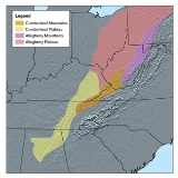
Cumberland Plateau
Encyclopedia

Appalachian Plateau
The Appalachian Plateau is the western part of the Appalachian mountains, stretching from New York and Alabama. The plateau is a second level United States physiographic region....
. It includes much of eastern Kentucky
Kentucky
The Commonwealth of Kentucky is a state located in the East Central United States of America. As classified by the United States Census Bureau, Kentucky is a Southern state, more specifically in the East South Central region. Kentucky is one of four U.S. states constituted as a commonwealth...
and western West Virginia
West Virginia
West Virginia is a state in the Appalachian and Southeastern regions of the United States, bordered by Virginia to the southeast, Kentucky to the southwest, Ohio to the northwest, Pennsylvania to the northeast and Maryland to the east...
, part of Tennessee
Tennessee
Tennessee is a U.S. state located in the Southeastern United States. It has a population of 6,346,105, making it the nation's 17th-largest state by population, and covers , making it the 36th-largest by total land area...
, and a small portion of northern Alabama
Alabama
Alabama is a state located in the southeastern region of the United States. It is bordered by Tennessee to the north, Georgia to the east, Florida and the Gulf of Mexico to the south, and Mississippi to the west. Alabama ranks 30th in total land area and ranks second in the size of its inland...
and northwest Georgia http://www.dogwoodalliance.org/content/view/43/104/. The terms "Allegheny Plateau
Allegheny Plateau
The Allegheny Plateau is a large dissected plateau area in western and central New York, northern and western Pennsylvania, northern and western West Virginia, and eastern Ohio...
" and the "Cumberland Plateau" both refer to the dissected plateau lands lying west of the main Appalachian Mountains
Appalachian Mountains
The Appalachian Mountains #Whether the stressed vowel is or ,#Whether the "ch" is pronounced as a fricative or an affricate , and#Whether the final vowel is the monophthong or the diphthong .), often called the Appalachians, are a system of mountains in eastern North America. The Appalachians...
. The terms stem from historical usage rather than geological difference, so there is no strict dividing line between the two. Two major rivers share the names of the plateaus, with the Allegheny River
Allegheny River
The Allegheny River is a principal tributary of the Ohio River; it is located in the Eastern United States. The Allegheny River joins with the Monongahela River to form the Ohio River at the "Point" of Point State Park in Downtown Pittsburgh, Pennsylvania...
rising in the Allegheny Plateau and the Cumberland River
Cumberland River
The Cumberland River is a waterway in the Southern United States. It is long. It starts in Harlan County in far southeastern Kentucky between Pine and Cumberland mountains, flows through southern Kentucky, crosses into northern Tennessee, and then curves back up into western Kentucky before...
rising in the Cumberland Plateau.
Geography
The Cumberland Plateau is a deeply dissected plateauDissected plateau
A dissected plateau is a plateau area that has been severely eroded so that the relief is sharp. Such an area may be referred to as mountainous, but dissected plateaus are distinguishable from orogenic mountain belts by the lack of folding, metamorphism, extensive faulting, or magmatic activity...
, with topographic
Topography
Topography is the study of Earth's surface shape and features or those ofplanets, moons, and asteroids...
relief commonly of about four hundred feet (120 meters), and frequent sandstone
Sandstone
Sandstone is a sedimentary rock composed mainly of sand-sized minerals or rock grains.Most sandstone is composed of quartz and/or feldspar because these are the most common minerals in the Earth's crust. Like sand, sandstone may be any colour, but the most common colours are tan, brown, yellow,...
outcrop
Outcrop
An outcrop is a visible exposure of bedrock or ancient superficial deposits on the surface of the Earth. -Features:Outcrops do not cover the majority of the Earth's land surface because in most places the bedrock or superficial deposits are covered by a mantle of soil and vegetation and cannot be...
pings and bluffs.
At Kentucky's Pottsville Escarpment
Pottsville Escarpment
The Pottsville Escarpment is a resistant sandstone belt of cliffs and steep sided, narrow crested valleys in eastern Kentucky, USA. It features rock shelters, waterfalls, and natural bridges...
, which is the transition from the Cumberland Plateau to the Bluegrass
Bluegrass region
The Bluegrass Region is a geographic region in the state of Kentucky, United States. It occupies the northern part of the state and since European settlement has contained a majority of the state's population and its largest cities....
in the north and the Pennyrile
Pennyroyal Plateau
The Pennyroyal Plateau, or, as it is more commonly called in Kentucky, the Pennyrile, is a large area of the state that features rolling hills, caves, and karst topography in general. It is also called the "Mississippi Plateau"....
in the south, there are many spectacular cliff
Cliff
In geography and geology, a cliff is a significant vertical, or near vertical, rock exposure. Cliffs are formed as erosion landforms due to the processes of erosion and weathering that produce them. Cliffs are common on coasts, in mountainous areas, escarpments and along rivers. Cliffs are usually...
s, gorges, rockhouse
Rockhouse
Rockhouse is a colloquial term in the eastern United States for the geologic feature known as a rock shelter.Rockhouse also refers to geographic features, including:*Creelsboro Natural Bridge, Kentucky*Rockhouse at Hocking Hills State Park, Ohio...
s, natural bridges
Natural arch
A natural arch or natural bridge is a natural geological formation where a rock arch forms, with an opening underneath. Most natural arches form as a narrow ridge, walled by cliffs, become narrower from erosion, with a softer rock stratum under the cliff-forming stratum gradually eroding out until...
, and waterfall
Waterfall
A waterfall is a place where flowing water rapidly drops in elevation as it flows over a steep region or a cliff.-Formation:Waterfalls are commonly formed when a river is young. At these times the channel is often narrow and deep. When the river courses over resistant bedrock, erosion happens...
s. In Tennessee, the Cumberland Plateau's western border is the Highland Rim
Highland Rim
The Highland Rim is a geographic term for the area in Tennessee surrounding the Central Basin. Nashville is largely surrounded by higher terrain in all directions....
east of the Nashville Basin
Nashville Basin
The Nashville Basin, also known as the Central Basin, is a term often used to describe the area surrounding Nashville, Tennessee. The Central Basin was caused by an uplifting known as the Nashville Dome. The Nashville Dome is evidenced by the underlying rock strata that all dip downwards away from...
, and its eastern edge is marked by Walden Ridge
Walden Ridge
Walden Ridge is a mountain ridge and escarpment located in Tennessee, in the United States. It marks the eastern edge of the Cumberland Plateau and is generally considered part of it. Walden Ridge is about long, running generally north-south...
, which continues south into Alabama as Sand Mountain
Sand Mountain (Alabama)
Sand Mountain is a sandstone plateau in northeastern Alabama and northwestern Georgia. It is part of the southern tip of the Appalachian mountain chain. Geologically a continuation of Walden Ridge, Sand Mountain is part of the Cumberland Plateau, separated from the main portion of the plateau by...
. Walden Ridge and Sand Mountain are separated from the main portion of the Cumberland Plateau by the Sequatchie Valley
Sequatchie Valley
Sequatchie Valley is a relatively long and narrow valley in the U.S. state of Tennessee and, in some definitions, Alabama. It is generally considered to be part of the Cumberland Plateau region of the Appalachian Mountains; it was probably formed by erosion of a compression anticline, rather than...
, which extends into central Alabama under other names.
In Kentucky
Kentucky
The Commonwealth of Kentucky is a state located in the East Central United States of America. As classified by the United States Census Bureau, Kentucky is a Southern state, more specifically in the East South Central region. Kentucky is one of four U.S. states constituted as a commonwealth...
, the height of the plateau's hills increases from northwest to southeast, with the westernmost areas of the plateau having a relief of around 200 feet and an appearance similar to the knobs region
Knobs region
The Knobs Region is located in the US state of Kentucky. It is a narrow, horseshoe shaped region consisting of hundreds of isolated hills. The region wraps around the bluegrass region in the center of the state...
, whereas areas near Black Mountain
Black Mountain (Kentucky)
Black Mountain is the highest natural point in the Commonwealth of Kentucky, USA, with a summit elevation of above mean sea level and a top to bottom height of over . The summit is located at in Harlan County, Kentucky near the Virginia border, just above the towns of Lynch, Kentucky and...
have a relief exceeding 2,500 feet.
Geology and physiography
The Cumberland Plateau is a physiographic sectionPhysiographic regions of the world
The physiographic regions of the world are a means of defining the Earth's landforms into distinct regions based upon classic 1916 three-tiered approach defining divisions, provinces, and sections...
of the larger Appalachian Plateau
Appalachian Plateau
The Appalachian Plateau is the western part of the Appalachian mountains, stretching from New York and Alabama. The plateau is a second level United States physiographic region....
province, which in turn is part of the larger Appalachian
Appalachian Mountains
The Appalachian Mountains #Whether the stressed vowel is or ,#Whether the "ch" is pronounced as a fricative or an affricate , and#Whether the final vowel is the monophthong or the diphthong .), often called the Appalachians, are a system of mountains in eastern North America. The Appalachians...
physiographic division.
The Cumberland Plateau is contiguous with the Allegheny Plateau on the northern side, the only real difference being local naming. The sedimentary rock
Sedimentary rock
Sedimentary rock are types of rock that are formed by the deposition of material at the Earth's surface and within bodies of water. Sedimentation is the collective name for processes that cause mineral and/or organic particles to settle and accumulate or minerals to precipitate from a solution....
s that compose both plateaus are of Mississippian and Pennsylvanian
Pennsylvanian
The Pennsylvanian is, in the ICS geologic timescale, the younger of two subperiods of the Carboniferous Period. It lasted from roughly . As with most other geochronologic units, the rock beds that define the Pennsylvanian are well identified, but the exact date of the start and end are uncertain...
geological
Geology
Geology is the science comprising the study of solid Earth, the rocks of which it is composed, and the processes by which it evolves. Geology gives insight into the history of the Earth, as it provides the primary evidence for plate tectonics, the evolutionary history of life, and past climates...
age, composed of near shore sediments washed westward from the old Appalachian Mountains
Appalachian Mountains
The Appalachian Mountains #Whether the stressed vowel is or ,#Whether the "ch" is pronounced as a fricative or an affricate , and#Whether the final vowel is the monophthong or the diphthong .), often called the Appalachians, are a system of mountains in eastern North America. The Appalachians...
. Some rock
Rock (geology)
In geology, rock or stone is a naturally occurring solid aggregate of minerals and/or mineraloids.The Earth's outer solid layer, the lithosphere, is made of rock. In general rocks are of three types, namely, igneous, sedimentary, and metamorphic...
layers were laid down in shallow coastal waters, some, including bituminous coal
Bituminous coal
Bituminous coal or black coal is a relatively soft coal containing a tarlike substance called bitumen. It is of higher quality than lignite coal but of poorer quality than Anthracite...
seams were laid onshore in swampy environments. These are interlaced with delta formations of cross-bedded sandstones and occasionally conglomerate. There are numerous discontinuities
Discontinuity
Discontinuity may refer to:*Discontinuity , a harmless irregularity in a casting*Discontinuity in geotechnics is a plane or surface marking a change in physical or chemical properties in a soil or rock mass...
in the beds, where they were raised high enough to be eroded, then lowered to have more sediments added on top.
Natural history and conservation
The plateau contains some of the largest stretches of contiguous forest in the eastern United States. Regionally, forests are intermediate between oak (Quercus) and hickory (Carya) forest types with pines (Pinus) occurring on dry, upland sites and mesophyticAppalachian mixed mesophytic forests
The Appalachian mixed mesophytic forests are an ecoregion of mesophytic plants west of the Appalachian Mountains in the southeastern United States.-Setting:...
species occurring in protected coves.
The Oak Ridge National Laboratory
Oak Ridge National Laboratory
Oak Ridge National Laboratory is a multiprogram science and technology national laboratory managed for the United States Department of Energy by UT-Battelle. ORNL is the DOE's largest science and energy laboratory. ORNL is located in Oak Ridge, Tennessee, near Knoxville...
is involved with the conservation of the mixed mesophytic forests within the Northern Cumberland Plateau. Conservation organizations active on the Cumberland Plateau include The Nature Conservancy
The Nature Conservancy
The Nature Conservancy is a US charitable environmental organization that works to preserve the plants, animals, and natural communities that represent the diversity of life on Earth by protecting the lands and waters they need to survive....
, the Doris Duke Charitable Foundation, and the Natural Resources Defense Council
Natural Resources Defense Council
The Natural Resources Defense Council is a New York City-based, non-profit, non-partisan international environmental advocacy group, with offices in Washington DC, San Francisco, Los Angeles, Chicago, and Beijing...
.
Further reading
- Caudill, Harry M.Harry M. CaudillHarry M. Caudill was an American author, historian, lawyer, legislator, and environmentalist from Letcher County, in the coalfields of southeastern Kentucky.-Biography:...
, Night Comes to the CumberlandsNight Comes to the CumberlandsNight Comes to the Cumberlands is a book by Harry Caudill that brought attention to poverty in Appalachia and is credited with making the Appalachian area a focus of the United State government's "War on Poverty"...
(1962). ISBN 0-316-13212-8