
Interstate 575
Encyclopedia
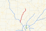
Interstate 575 is an Interstate Highway
spur route
in the United States
, which branches off Interstate 75
in Kennesaw
and connects the metro Atlanta
area with the north Georgia mountains
. I-575 is also the unsigned State Route 417 and is cosigned as SR 5
. I-575 begins in northern Cobb County
near Kennesaw and goes mostly through Cherokee County
, ending at its northern border with Pickens County
, where it continues as SR 515
. It is officially 31 miles (49.85 km) long, though this extends it past a surface intersection.
It is also the Phillip M. Landrum Memorial Highway in honor of Phillip M. Landrum
(1907–1990), who was a U.S. Representative from Georgia
and died in 1990.
The exit from I-75 to I-575 was formerly exit #115 and it is now mile #268. This change was made when Georgia Department of Transportation
(GDOT) went from numbered exits
consecutively to numbering them by the nearest mile marker
.
of grass, along with crepe myrtle (a locally-common landscaping tree) or wildflower
s, both of which are summer-flowering. Each direction has one truck lane
for climbing uphill (mile 12 to 13 northbound, mile 10 to 9 southbound), two extended acceleration lanes (north from Towne Lake Parkway and south from Marietta Highway), and two auxiliary lanes (connecting Bells Ferry and Chastain Roads).
The city of Holly Springs
recently annexed land to Sixes Road. Other cities that have annexed I-575 include Canton
and Ball Ground
.
I-575 crosses the Little River between Woodstock and Holly Springs, and has four bridges over the Etowah River
in northeastern Canton, as it flows under the southern half of the Riverstone Parkway (former SR 5) exit. It also crosses Noonday Creek
between Barrett Parkway and Chastain Road, at the northeast corner of Town Center at Cobb regional mall. That stream
roughly follows the freeway northward on the east side of the road, passing alongside the northbound ramp to SR 92, and then crossing back under to the northwest just before Towne Lake Parkway.
At the Canton and Holly Springs exit, the two city limits meet. Here the road (old SR 5) was realigned to cross 575 at a more perpendicular
angle when I-575 was constructed. This left two dead-end
streets: Hiram Way in Holly Springs, and Travis Tritt Lane
in Canton. Just north of here, I-575 crosses Univeter Road.
, I-575 was mostly constructed as a suburban spur highway, intended to serve an undeveloped area for future settlement, rather than as one to relieve traffic
, or to link I-75 to an existing city or large town. It has since accelerated land development
and population growth
in the area far beyond what GDOT predicted, essentially causing its own traffic. (After just 20 years, it carried as many cars per day as it was expected to in 40 years.)
The first stage of I-575 was constructed in 1979 from I-75 to SR 92
near Woodstock
and was opened to traffic on October 16, 1980. The next section to Georgia 20 began construction in 1981, and was opened on March 29, 1985 as far north as exit 11 (now mile 20). The section between the original exit 8 (now 16A) and exit 10 (now 19) was originally part of the Canton
Bypass (SR 20), which was constructed in 1978. The final portion of I-575 to past Howell Bridge Road and SR 372 opened later, and that extended the highway to its present length of 31 miles (50 km), although the northernmost one mile (1.6 km) given in this length was not constructed up to Interstate Highway standards, since it extends past a surface ("at-grade") intersection. This final portion north of Canton was constructed of concrete
rather than asphalt
, and narrow black lines run on either side of the white lane
markings
.
The road was last repaved in summer 2009, with funds from the American Recovery and Reinvestment Act. In 2008, GDOT added a cable barrier
.
dealership on the east (northbound) side. On the opposite side, it required a noise barrier
wall north of Dupree Road because of its proximity to existing homes. The other bid was for a much shorter distance of just a few yards or meters on the northeast side of Canton, between SR 20 (Cumming
Highway) and SR 5 Business (Riverstone Parkway).
—far beyond the I-575 terminal point. SR 205 was also deleted when I-575 opened in Cherokee County in 1985, returning what is now the northernmost part of Bells Ferry Road to local responsibility. Part of its old route was briefly designated by a state project route number that appeared on maps as SR 754. This mostly consisted of a widening project planned on the route. The counties along the way did not want to fund it since the route had been state-maintained, and then returned to county maintenance in 1986. When Woodstock, Georgia
rejected that widening project (as it would have destroyed its downtown
area), SR 754 was truncated south of SR 92
, and it was fully turned back in 2001 when the entire project was completed. State route 754 was not signed; however, it still continues to appear on Google Maps
and other Web mapping
services .
Most of the former SR 5 did not get such treatment, and all of it was originally deleted except a portion in Canton, Georgia
designated as SR 5 Business and another part that joined SR 372 to the new route using part of the old route. Another such SR 5 Business was added from old Georgia 5 in Ball Ground in 1989, completing a business loop through Ball Ground that is still largely covered by Georgia 372. Georgia SR 5 continues northward co-signed with SR 515, Corridor A of the Appalachian Development Highway System. Along this route, SR 5 and SR 5 Alternate have been abandoned by the state and left to the counties and cities to maintain. The Georgia Northeastern Railroad
still follows much of the old route.
plan from the Georgia Regional Transportation Authority
(GRTA). The extra lane in each direction would extend up to Sixes Road, and was planned to be an HOV
/HOT lane
, with special exits at smaller roads that currently do not have any direct access. GRTA proposes bus rapid transit
along the route.
There would also be separate new HOV ramps built to southbound and from northbound I-75. That highway was proposed to have eight lanes added to it, with one pair going straight to I-575. All widening on I-575 would be done in the median.
In 2009, the plan was scaled-back to include two reversible lane
s on I-75, with one extending up I-575.
, rather than an HOV/HOT exit. Crossing at mile 9.6, it could be given mile number 9 or 10, and would have been 5A under the actual exit numbers used until 2000. The project will cost 22 million dollars. However, the project is part of a greater plan to create a northern by-pass of Woodstock, connecting north of the downtown to Arnold Mill Road, helping to relieve some of the congestion in the traffic-prone downtown. The intent to create a new area of development around the exit, however, is clear.
The background on Rope Mill Road was that the overpass presently there originally was built to provide access to private property and the now-defunct Little River Wildlife Management Area west of I-575. The overpass was actually part of an old alignment of Rope Mill Road that was relocated onto a frontage road east of I-575, as the bridge was a connection to a severed alignment of the road west of I-575. Rope Mill Road originally extended from Woodstock to Lebanon
(locally known as Toonigh) before the bridge over the Little River was removed in the early 1990s.
Federal Highway Administration
officials had earlier rejected the plan due to its proximity to two other exits. There had also been a plan to put only a half-diamond exit on the north side of the road, using Woodstock Parkway on the east side and a new access road on the west side to connect it to Towne Lake, which would then have its ramps on the north side removed. Woodstock Parkway would have become northbound-only, with the new road being southbound only. This was objected to by residents who would have been up against the new road.
Interstate Highway System
The Dwight D. Eisenhower National System of Interstate and Defense Highways, , is a network of limited-access roads including freeways, highways, and expressways forming part of the National Highway System of the United States of America...
spur route
Spur route
A spur route is a short road forming a branch from a longer, more important route . A bypass or beltway is never considered a true spur route as it typically reconnects with the major road...
in the United States
United States
The United States of America is a federal constitutional republic comprising fifty states and a federal district...
, which branches off Interstate 75
Interstate 75 in Georgia
In the U.S. state of Georgia, Interstate 75 runs north–south along the U.S. Route 41 corridor on the western side of the state, passing through the cities of Valdosta, Macon and Atlanta. It is also designated — but not signed — as State Route 401...
in Kennesaw
Kennesaw, Georgia
Kennesaw is a city in Cobb County, Georgia, United States. It had a population of 29,783 according to the 2010 census. It is part of the Atlanta metropolitan area. Founded in 1887, Kennesaw has a past surrounded with railroad history...
and connects the metro Atlanta
Metro Atlanta
The Atlanta metropolitan area or metro Atlanta, officially designated by the US Census Bureau as the Atlanta-Sandy Springs-Marietta Metropolitan Statistical Area, is the most populous metro area in the U.S. state of Georgia and the ninth-largest metropolitan statistical area in the United States...
area with the north Georgia mountains
North Georgia mountains
The Georgia Mountains Region or North Georgia mountains or Northeast Georgia is an area that starts in the northeast corner of Georgia, United States, and spreads in a westerly direction. The mountains in this region are in the Blue Ridge mountain chain that ends in Georgia...
. I-575 is also the unsigned State Route 417 and is cosigned as SR 5
Georgia State Route 5
State Route 5 is a route that bisects northern Georgia. It passes through the county seats of Blue Ridge, Ellijay, Jasper, Canton, Marietta, and Douglasville. Along the way, it overlaps one of metro Atlanta's freeways, I-575. From the Cherokee/Pickens County line to Blue Ridge, Georgia 5 is...
. I-575 begins in northern Cobb County
Cobb County, Georgia
Cobb County is a county located in the U.S. state of Georgia. Its county seat and largest city is Marietta, which is located in the center of the county. The county was named for Thomas Willis Cobb, who in the early 19th century was a United States representative and senator from Georgia...
near Kennesaw and goes mostly through Cherokee County
Cherokee County, Georgia
As of the census of 2000, there were 141,903 people, 49,495 households, and 39,200 families residing in the county. The population density was 335 people per square mile . There were 51,937 housing units at an average density of 123 per square mile...
, ending at its northern border with Pickens County
Pickens County, Georgia
Pickens County is a county located in the U.S. state of Georgia. The 2000 Census showed a population of 22,983. The 2007 Census Estimate showed a population of 30,488...
, where it continues as SR 515
Georgia State Route 515
State Route 515 is a four-lane highway that begins at the northern terminus of I-575 at the Cherokee –Pickens county line in northern Georgia. The route was built to give motorists in the north Georgia mountains better access to Atlanta and its outlying suburbs, as opposed to the old ST 5 and...
. It is officially 31 miles (49.85 km) long, though this extends it past a surface intersection.
It is also the Phillip M. Landrum Memorial Highway in honor of Phillip M. Landrum
Phillip M. Landrum
Phillip Mitchell Landrum was a Democratic U.S. Representative from Georgia.Born in Martin, Georgia, Landrum attended the public schools and Mercer University, in Macon, Georgia....
(1907–1990), who was a U.S. Representative from Georgia
Georgia (U.S. state)
Georgia is a state located in the southeastern United States. It was established in 1732, the last of the original Thirteen Colonies. The state is named after King George II of Great Britain. Georgia was the fourth state to ratify the United States Constitution, on January 2, 1788...
and died in 1990.
The exit from I-75 to I-575 was formerly exit #115 and it is now mile #268. This change was made when Georgia Department of Transportation
Georgia Department of Transportation
The Georgia Department of Transportation is the organization in charge of developing and maintaining all state and federal roadways in the U.S. state of Georgia. In addition to highways, the department also has a limited role in developing public transportation and general aviation programs...
(GDOT) went from numbered exits
Exit number
An exit number is a number assigned to a road junction, usually an exit from a freeway. It is usually marked on the same sign as the destinations of the exit, as well as a sign in the gore....
consecutively to numbering them by the nearest mile marker
Milestone
A milestone is one of a series of numbered markers placed along a road or boundary at intervals of one mile or occasionally, parts of a mile. They are typically located at the side of the road or in a median. They are alternatively known as mile markers, mileposts or mile posts...
.
Route description
For almost all of its length, I-575 has two lanes in each direction, with a road medianCentral reservation
On divided roads, such as divided highways or freeways/motorways, the central reservation , median, parkway , median strip or central nature strip is the area which separates opposing lanes of traffic...
of grass, along with crepe myrtle (a locally-common landscaping tree) or wildflower
Wildflower
A wildflower is a flower that grows wild, meaning it was not intentionally seeded or planted. Yet "wildflower" meadows of a few mixed species are sold in seed packets. The term "wildflower" has been made vague by commercial seedsmen who are interested in selling more flowers or seeds more...
s, both of which are summer-flowering. Each direction has one truck lane
Lane
A lane is a part of the roadway within a road marked out for use by a single line of vehicles in such a way as to control and guide drivers for the purpose of reducing traffic conflicts. Most public roads have at least two lanes, one for traffic in each direction, separated by Lane markings...
for climbing uphill (mile 12 to 13 northbound, mile 10 to 9 southbound), two extended acceleration lanes (north from Towne Lake Parkway and south from Marietta Highway), and two auxiliary lanes (connecting Bells Ferry and Chastain Roads).
The city of Holly Springs
Holly Springs, Georgia
Holly Springs is a city in Cherokee County, Georgia, United States. The population was 4,195 at the 2000 census. Census Estimates for 2005 show a population of 4,328...
recently annexed land to Sixes Road. Other cities that have annexed I-575 include Canton
Canton, Georgia
Canton is a city in and the county seat of Cherokee County, Georgia, United States. As of the 2010 census, the city had a population of 22,958.-Geography:Canton is located at ....
and Ball Ground
Ball Ground, Georgia
Ball Ground is a city in Cherokee County, Georgia, United States. The population was 1433 at the 2010 census.Ball Ground is at the northernmost end of Georgia Interstate 575, north of Canton at exit 20 on I-575, and ending seven miles north at exit 27...
.
I-575 crosses the Little River between Woodstock and Holly Springs, and has four bridges over the Etowah River
Etowah River
The Etowah River is a waterway that rises northwest of Dahlonega, Georgia, north of Atlanta. Its name is the Cherokee version of the original Muskogee word Etalwa, which means a "trail crossing". On Matthew Carey's 1795 map the river was labeled "High Town River"...
in northeastern Canton, as it flows under the southern half of the Riverstone Parkway (former SR 5) exit. It also crosses Noonday Creek
Noonday Creek
Noonday Creek is a stream in Cobb and Cherokee counties in the U.S. state of Georgia. The stream begins near Kennesaw Mountain and ends at Lake Allatoona.-Geography:...
between Barrett Parkway and Chastain Road, at the northeast corner of Town Center at Cobb regional mall. That stream
Stream
A stream is a body of water with a current, confined within a bed and stream banks. Depending on its locale or certain characteristics, a stream may be referred to as a branch, brook, beck, burn, creek, "crick", gill , kill, lick, rill, river, syke, bayou, rivulet, streamage, wash, run or...
roughly follows the freeway northward on the east side of the road, passing alongside the northbound ramp to SR 92, and then crossing back under to the northwest just before Towne Lake Parkway.
At the Canton and Holly Springs exit, the two city limits meet. Here the road (old SR 5) was realigned to cross 575 at a more perpendicular
Perpendicular
In geometry, two lines or planes are considered perpendicular to each other if they form congruent adjacent angles . The term may be used as a noun or adjective...
angle when I-575 was constructed. This left two dead-end
Cul-de-sac
A cul-de-sac is a word of French origin referring to a dead end, close, no through road or court meaning dead-end street with only one inlet/outlet...
streets: Hiram Way in Holly Springs, and Travis Tritt Lane
Travis Tritt
James Travis Tritt is an American country music singer from Marietta, Georgia. He signed to Warner Bros. Records in 1989, releasing seven studio albums and a greatest hits package for the label between then and 1999. In the 2000s, he released two albums on Columbia Records and one for the defunct...
in Canton. Just north of here, I-575 crosses Univeter Road.
History
Like I-985Interstate 985
Interstate 985 is a long auxiliary Interstate Highway in Georgia. It begins at Interstate 85 near Suwanee and continues northward to the north Georgia city of Gainesville...
, I-575 was mostly constructed as a suburban spur highway, intended to serve an undeveloped area for future settlement, rather than as one to relieve traffic
Traffic
Traffic on roads may consist of pedestrians, ridden or herded animals, vehicles, streetcars and other conveyances, either singly or together, while using the public way for purposes of travel...
, or to link I-75 to an existing city or large town. It has since accelerated land development
Land development
Land development refers to altering the landscape in any number of ways such as:* changing landforms from a natural or semi-natural state for a purpose such as agriculture or housing...
and population growth
Population growth
Population growth is the change in a population over time, and can be quantified as the change in the number of individuals of any species in a population using "per unit time" for measurement....
in the area far beyond what GDOT predicted, essentially causing its own traffic. (After just 20 years, it carried as many cars per day as it was expected to in 40 years.)
The first stage of I-575 was constructed in 1979 from I-75 to SR 92
Georgia State Route 92
State Route 92 is a highway in the U.S. state of Georgia. The road runs for from Griffin to Roswell. Primarily signed from south to north, Route 92 is a rural route that passes through three county seats.- Route description :...
near Woodstock
Woodstock, Georgia
Woodstock is a city in Cherokee County, Georgia, United States. The population was 23,896 at the 2010 census.Originally a stop on the Louisville and Nashville Railroad, Woodstock is now considered part of the Atlanta metropolitan area...
and was opened to traffic on October 16, 1980. The next section to Georgia 20 began construction in 1981, and was opened on March 29, 1985 as far north as exit 11 (now mile 20). The section between the original exit 8 (now 16A) and exit 10 (now 19) was originally part of the Canton
Canton, Georgia
Canton is a city in and the county seat of Cherokee County, Georgia, United States. As of the 2010 census, the city had a population of 22,958.-Geography:Canton is located at ....
Bypass (SR 20), which was constructed in 1978. The final portion of I-575 to past Howell Bridge Road and SR 372 opened later, and that extended the highway to its present length of 31 miles (50 km), although the northernmost one mile (1.6 km) given in this length was not constructed up to Interstate Highway standards, since it extends past a surface ("at-grade") intersection. This final portion north of Canton was constructed of concrete
Concrete
Concrete is a composite construction material, composed of cement and other cementitious materials such as fly ash and slag cement, aggregate , water and chemical admixtures.The word concrete comes from the Latin word...
rather than asphalt
Asphalt
Asphalt or , also known as bitumen, is a sticky, black and highly viscous liquid or semi-solid that is present in most crude petroleums and in some natural deposits, it is a substance classed as a pitch...
, and narrow black lines run on either side of the white lane
Lane
A lane is a part of the roadway within a road marked out for use by a single line of vehicles in such a way as to control and guide drivers for the purpose of reducing traffic conflicts. Most public roads have at least two lanes, one for traffic in each direction, separated by Lane markings...
markings
Road surface marking
Road surface marking is any kind of device or material that is used on a road surface in order to convey official information. They can also be applied in other facilities used by vehicles to mark parking spaces or designate areas for other uses....
.
The road was last repaved in summer 2009, with funds from the American Recovery and Reinvestment Act. In 2008, GDOT added a cable barrier
Cable barrier
Cable barrier, sometimes referred to as guard cable, is a type of roadside or median barrier. It consists of steel wire ropes mounted on weak posts. As is the case with any roadside barrier, its primary purpose is to prevent a vehicle from leaving the traveled way and striking a fixed object or...
.
Auxiliary lanes
In February 2006, GDOT let two bids to add auxiliary lanes in both directions on the road shoulder, in between two pairs of short-spaced exits. The larger project was in Woodstock between Georgia 92 and Towne Lake Parkway, where nearly two million dollars were spent. This was in a mainly grassy area next to an recreational vehicleRecreational vehicle
Recreational vehicle or RV is, in North America, the usual term for a Motor vehicle or trailer equipped with living space and amenities found in a home.-Features:...
dealership on the east (northbound) side. On the opposite side, it required a noise barrier
Noise barrier
A noise barrier is an exterior structure designed to protect sensitive land uses from noise pollution...
wall north of Dupree Road because of its proximity to existing homes. The other bid was for a much shorter distance of just a few yards or meters on the northeast side of Canton, between SR 20 (Cumming
Cumming, Georgia
Cumming is a city in Forsyth County, Georgia, United States. The population was 5,430 at the 2010 census. However, places with a Cumming mailing address have a population of around 100,000...
Highway) and SR 5 Business (Riverstone Parkway).
Relocation of State Route 5
I-575 is now co-signed throughout its length with SR 5, which was completely removed from its former alignment in 1985–86 over a nearly 70 miles (112.7 km) stretch from Marietta all the way to north of EllijayEllijay, Georgia
Ellijay is a city in Gilmer County, Georgia, United States. The population was 1,584 at the 2000 census. The city is the county seat of Gilmer County.Ellijay lies where two rivers, the Ellijay and the Cartecay, come together to form the Coosawattee River...
—far beyond the I-575 terminal point. SR 205 was also deleted when I-575 opened in Cherokee County in 1985, returning what is now the northernmost part of Bells Ferry Road to local responsibility. Part of its old route was briefly designated by a state project route number that appeared on maps as SR 754. This mostly consisted of a widening project planned on the route. The counties along the way did not want to fund it since the route had been state-maintained, and then returned to county maintenance in 1986. When Woodstock, Georgia
Woodstock, Georgia
Woodstock is a city in Cherokee County, Georgia, United States. The population was 23,896 at the 2010 census.Originally a stop on the Louisville and Nashville Railroad, Woodstock is now considered part of the Atlanta metropolitan area...
rejected that widening project (as it would have destroyed its downtown
Downtown
Downtown is a term primarily used in North America by English speakers to refer to a city's core or central business district ....
area), SR 754 was truncated south of SR 92
Georgia State Route 92
State Route 92 is a highway in the U.S. state of Georgia. The road runs for from Griffin to Roswell. Primarily signed from south to north, Route 92 is a rural route that passes through three county seats.- Route description :...
, and it was fully turned back in 2001 when the entire project was completed. State route 754 was not signed; however, it still continues to appear on Google Maps
Google Maps
Google Maps is a web mapping service application and technology provided by Google, free , that powers many map-based services, including the Google Maps website, Google Ride Finder, Google Transit, and maps embedded on third-party websites via the Google Maps API...
and other Web mapping
Web mapping
Web mapping is the process of designing, implementing, generating and delivering maps on the World Wide Web and its product. While web mapping primarily deals with technological issues, web cartography additionally studies theoretic aspects: the use of web maps, the evaluation and optimization of...
services .
Most of the former SR 5 did not get such treatment, and all of it was originally deleted except a portion in Canton, Georgia
Canton, Georgia
Canton is a city in and the county seat of Cherokee County, Georgia, United States. As of the 2010 census, the city had a population of 22,958.-Geography:Canton is located at ....
designated as SR 5 Business and another part that joined SR 372 to the new route using part of the old route. Another such SR 5 Business was added from old Georgia 5 in Ball Ground in 1989, completing a business loop through Ball Ground that is still largely covered by Georgia 372. Georgia SR 5 continues northward co-signed with SR 515, Corridor A of the Appalachian Development Highway System. Along this route, SR 5 and SR 5 Alternate have been abandoned by the state and left to the counties and cities to maintain. The Georgia Northeastern Railroad
Georgia Northeastern Railroad
The Georgia Northeastern Railroad is a short line freight railroad which runs from the town of Elizabeth, Georgia to the city of Blue Ridge, Georgia. Goods hauled are mostly timber, grain, poultry, and marble products. The GNRR's subsidiary, the Blue Ridge Scenic Railway, also operates on this...
still follows much of the old route.
SR 20 exit
The I-575 and SR 20 interchange was originally a half-trumpet/half diamond interchange. Since SR 20 has always been a heavily traveled east-west highway, traffic buildup was a common occurrence. When Sembler Properties initiated plans to construct Canton Marketplace in conjunction with a much larger mixed-use plan (Canton Place), developers sought to re-design the interchange for a more effective design. In 2009, work on the new interchange was completed and has a full diamond interchange with one trumpet to I-575 South from SR 20 West and to Main Street from I-575 North. This is effective because it eliminates the use of traffic signals for two left-turning lanes thereby reducing traffic buildup on the 2-lane road in front of Canton Place.Widening
The southern part of I-575 was slated to be widened to a total of six through lanes in the next few years, as part of the Northwest Corridor HOV/BRTNorthwest Corridor HOV/BRT
The Northwest Corridor HOV/BRT is a Georgia Department of Transportation plan to put HOV lanes and bus rapid transit along Interstate 75 and Interstate 575 in the northwestern suburbs of metro Atlanta...
plan from the Georgia Regional Transportation Authority
Georgia Regional Transportation Authority
The Georgia Regional Transportation Authority or GRTA is a government agency in the U.S. state of Georgia...
(GRTA). The extra lane in each direction would extend up to Sixes Road, and was planned to be an HOV
High-occupancy vehicle lane
In transportation engineering and transportation planning, a high-occupancy vehicle lane is a lane reserved for vehicles with a driver and one or more passengers...
/HOT lane
High occupancy/toll and express toll lanes
High occupancy/toll lanes is a road pricing scheme that gives motorists in single-occupant vehicles access to high-occupancy vehicle lanes . Sometimes, entire roads are designated for the use of HOVs. Tolls are collected either by manned toll booths, automatic number plate recognition, or...
, with special exits at smaller roads that currently do not have any direct access. GRTA proposes bus rapid transit
Bus rapid transit
Bus rapid transit is a term applied to a variety of public transportation systems using buses to provide faster, more efficient service than an ordinary bus line. Often this is achieved by making improvements to existing infrastructure, vehicles and scheduling...
along the route.
There would also be separate new HOV ramps built to southbound and from northbound I-75. That highway was proposed to have eight lanes added to it, with one pair going straight to I-575. All widening on I-575 would be done in the median.
In 2009, the plan was scaled-back to include two reversible lane
Reversible lane
A reversible lane , called a counterflow lane or contraflow lane in transport engineering nomenclature, is a lane in which traffic may travel in either direction, depending on certain conditions...
s on I-75, with one extending up I-575.
Rope Mill Road
A new exit has also been approved in October 2005 by the GDOT at Rope Mill Road (Ashland Parkway to the west, Woodstock Parkway to the east and south), between Towne Lake Parkway and Sixes Road. This is planned to be a full diamond interchangeDiamond interchange
A diamond interchange is a common type of road junction, used where a freeway crosses a minor road. The freeway itself is grade-separated from the minor road, one crossing the other over a bridge...
, rather than an HOV/HOT exit. Crossing at mile 9.6, it could be given mile number 9 or 10, and would have been 5A under the actual exit numbers used until 2000. The project will cost 22 million dollars. However, the project is part of a greater plan to create a northern by-pass of Woodstock, connecting north of the downtown to Arnold Mill Road, helping to relieve some of the congestion in the traffic-prone downtown. The intent to create a new area of development around the exit, however, is clear.
The background on Rope Mill Road was that the overpass presently there originally was built to provide access to private property and the now-defunct Little River Wildlife Management Area west of I-575. The overpass was actually part of an old alignment of Rope Mill Road that was relocated onto a frontage road east of I-575, as the bridge was a connection to a severed alignment of the road west of I-575. Rope Mill Road originally extended from Woodstock to Lebanon
Lebanon, Georgia
Lebanon, Georgia is a community that is now absorbed into Holly Springs. While the community is locally known and still referred to as Toonigh, the community has a post office located in a small strip mall just south of the Georgia Northeastern Railroad that was posted as Lebanon, Georgia....
(locally known as Toonigh) before the bridge over the Little River was removed in the early 1990s.
Federal Highway Administration
Federal Highway Administration
The Federal Highway Administration is a division of the United States Department of Transportation that specializes in highway transportation. The agency's major activities are grouped into two "programs," the Federal-aid Highway Program and the Federal Lands Highway Program...
officials had earlier rejected the plan due to its proximity to two other exits. There had also been a plan to put only a half-diamond exit on the north side of the road, using Woodstock Parkway on the east side and a new access road on the west side to connect it to Towne Lake, which would then have its ramps on the north side removed. Woodstock Parkway would have become northbound-only, with the new road being southbound only. This was objected to by residents who would have been up against the new road.
Sixes Road widening
Sixes Road was widened from a two-lane road to a four-lane divided highway west of I-575 to Bells Ferry Road, where it continues into the BridgeMill development. The short section east of I-575, to where it ends at old SR 5, has also been widened to four lanes. However, when the road crosses over I-575, it only has had two lanes, going in both directions. Currently, the road is in process of being expanded to four lanes over the bridge. I-575's ramps are in the process of being expanded as well. In addition, a larger shoulder is under construction going north from the new Rope Mill exit.Exit list
The following exits are listed south to north with mile-log numbering, which replaced the old sequential exit numbers in 2000.| County | Location | Mile | old | # Exit number An exit number is a number assigned to a road junction, usually an exit from a freeway. It is usually marked on the same sign as the destinations of the exit, as well as a sign in the gore.... |
Destinations | Notes |
|---|---|---|---|---|---|---|
| Cobb Cobb County, Georgia Cobb County is a county located in the U.S. state of Georgia. Its county seat and largest city is Marietta, which is located in the center of the county. The county was named for Thomas Willis Cobb, who in the early 19th century was a United States representative and senator from Georgia... |
Southbound exit and northbound entrance | |||||
| 1 | 1 | |||||
| 2 | 3 | Chastain Road | access from I-575 south to I-75 north, I-75 south to I-575 north | |||
| 3 | 4 | |||||
| Cherokee Cherokee County, Georgia As of the census of 2000, there were 141,903 people, 49,495 households, and 39,200 families residing in the county. The population density was 335 people per square mile . There were 51,937 housing units at an average density of 123 per square mile... |
4 | 7 | ||||
| 5 | 8 | Towne Lake Parkway – Woodstock Woodstock, Georgia Woodstock is a city in Cherokee County, Georgia, United States. The population was 23,896 at the 2010 census.Originally a stop on the Louisville and Nashville Railroad, Woodstock is now considered part of the Atlanta metropolitan area... |
||||
| 6 | 11 | Sixes Road – Holly Springs Holly Springs, Georgia Holly Springs is a city in Cherokee County, Georgia, United States. The population was 4,195 at the 2000 census. Census Estimates for 2005 show a population of 4,328... |
||||
| 7 | 14 | Old SR 5 (Canton Road) – Holly Springs Holly Springs, Georgia Holly Springs is a city in Cherokee County, Georgia, United States. The population was 4,195 at the 2000 census. Census Estimates for 2005 show a population of 4,328... |
Road is named "Marietta Highway" north of the interchange and is generally referred to still as "Highway 5", which appears on most street name signs. | |||
| 8 | 16A | South end of SR 20/SR 140 overlap; exit is southernmost extent of the old Canton By-Pass, which opened prior to the completion of I-575 as a new alignment of SR 20 and forms a short freeway stretch to Marietta Highway; former SR 5 | ||||
| 9 | 16B | North end of SR 140 overlap | ||||
| 10 | 19 | North end of SR 20 overlap | ||||
| 11 | 20 | |||||
| 12 | 24 | Airport Drive - Cherokee County Airport Cherokee County Airport (Georgia) Cherokee County Airport is a county owned, public-use airport in Cherokee County, Georgia, United States. It is located six nautical miles northeast of the central business district of Canton, Georgia. The airport is adjacent to Interstate 575, about halfway between the city of Canton and the... , Ball Ground Ball Ground, Georgia Ball Ground is a city in Cherokee County, Georgia, United States. The population was 1433 at the 2010 census.Ball Ground is at the northernmost end of Georgia Interstate 575, north of Canton at exit 20 on I-575, and ending seven miles north at exit 27... |
||||
| 13 | 27 | |||||
| Northbound exit and southbound entrance |