
Hawaii hotspot
Encyclopedia
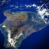
The Hawaii hotspot is the volcanic hotspot
that created the Hawaiian Islands
in the central Pacific Ocean
, and is one of Earth
's best-known and most heavily-studied hotspots.
While most volcanic activity occurs along tectonic plate boundaries, powered by the plates' movement, hotspots can occur far from such geological boundaries, so that a different model, involving unusual features in the Earth's lithosphere
, is required.
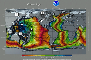
Seafloor spreading
pulls Hawaii's volcanoes northwest about 10 centimetres (3.9 in) a year, so that 30 million years ago, the Kure
and Midway atoll
s were located where the island of Hawai'i is now. The oldest extant volcano in the chain, Meiji Seamount
, began to form 86 million years ago; the hotspot may be older, however, since subduction
of tectonic plates on the margin between the Pacific
and Eurasian plate
s may have destroyed older volcanoes.
The Hawaii hotspot has created the Hawaiian – Emperor seamount chain comprising at least 129 volcanoes arranged in a line with a sharp bend. More than 123 of these are extinct volcanoes, seamount
s, and atoll
s, four are active volcanoes, and two are dormant volcanoes. Hawaiian volcanoes range in age from 300,000 to 86 million years, progressing from southeast to northwest. This chain includes the Hawaiian Ridge, consisting of the islands of the Hawaiian chain northwest to Kure Atoll
, and the Emperor seamounts, a linear region of islands, seamounts, atolls, shallows, banks, and reefs along a line trending southeast to northwest beneath the southern Pacific Ocean. The chain stretches over 5800 kilometres (3,604 mi) from the Aleutian Trench
in the far northwest Pacific to Lōihi Seamount
, the youngest volcano in the chain, lying about 35 kilometres (22 mi) southeast of the Island of Hawai'i.
A bend corresponding to rocks between 41 and 43 million years old, sharply divides the Hawaiian and Emperor sections. The bend is now thought to result from movement of the hotspot, superseding the theory of a relatively sudden change in the direction of plate motion.
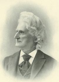
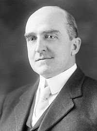
Ancient Hawaiian fishermen were the first to recognize the increasing age of the islands towards the northwest, noting that they were ever more heavily eroded as one progressed in that direction. James Dwight Dana
directed the earliest formal geological study, from 1880 to 1881, and first confirmed the relationship between age and location, again based on erosion. In 1912, geologist Thomas Jaggar
founded the Hawaiian Volcano Observatory
, initiating continuous scientific volcano observation on the island of Hawai'i. The model for the evolution of Hawaiian volcanoes
was completed in 1946. J. Tuzo Wilson proposed the hotspot theory in 1963, using the Hawaii island chain data. In the 1970s, the project of mapping Hawaii's seafloor was undertaken in the continuing effort to gain more information regarding the area's complex geology
.
generally focus deformation and volcanism at plate boundaries. However, the Hawaii hotspot is more than 3200 kilometres (1,988 mi) from the nearest plate boundary. In 1963, Canadian geophysicist J. Tuzo Wilson proposed the hotspot theory
to explain how these zones of deformation and volcanism form in plate interiors.
s, that sustain long-lasting volcanic activity. This "mid-plate volcanism" builds mountains that rise from the relatively featureless sea floor, initially as seamount
s, which eventually rise above the surface, forming volcanic islands. The hotspot remains relatively stationary, as Earth's tectonic plates slide over it, carrying the volcanoes with them. When the magma supply is cut by the plate's motion and the volcano becomes extinct, the island eventually erodes below the waves, again becoming a seamount. Meanwhile, a new volcano forms over the hotspot, forming another new island. The process continues until the mantle plume collapses.
According to Wilson, the Hawaiian chain's volcanoes should be progressively older and increasingly eroded northwestward from the hotspot. The oldest rocks in the main Hawaiian islands, the rocks on Kauai
, are about 5.5 million years old and deeply eroded. In contrast, the rocks of the "Big Island
", and those of Loihi, are under 0.7 million years old. New lava is constantly emitted from the Kilauea caldera
on Hawaii's Big Island.
 This cycle of growth and later dormancy, forms long chains of volcanic islands over many millions of years, and in the case of Hawaii, it has left a trail of volcanic islands and seamounts across the Pacific Ocean floor. The chain's length, orientation and the distance between volcanoes records the direction and speed of the Pacific Plate
's movement. Approximately 40–50 million years ago, it is thought to have suddenly changed direction, because of the subduction of the spreading ridge separating the Pacific and Izanagi plate
s, and the initiation of subduction along much of the Pacific Plate's western boundary. The change in direction was marked by an L-shaped bend in the seamount chain, easily visible in raised-relief map
s. However, this part of the theory has recently been challenged, and the bend might be attributed to the movement of the hotspot itself.
Geophysicists generally believe that hotspots originate at one of two major boundaries deep in the Earth. The shallow option is an interface in the lower mantle
between an upper convecting
layer and a lower non-convecting layer. The deeper option is the D
. A mantle plume
would initiate at the interface when the warmer lower layer heats a portion of the cooler upper layer. This heated, buoyant, and less-viscous
portion of the upper layer would become less dense due to thermal expansion
, and rise towards the surface as a Rayleigh-Taylor instability
or gravitational instability. When the mantle plume reaches the base of the lithosphere
, the plume heats it and produces melt. This magma
then makes its way to the surface, where it is erupted as lava
.
Arguments for the validity of the hotspot theory generally center on:
and asthenosphere
. Because of shifting plate boundaries, the area around Hawaii was vastly different 70–100 million years ago, and there may have been a spreading ridge (the Pacific–Kula Ridge
) in the area that disappeared in the early Tertiary
period, about 65 million years ago. After changing plate dynamics moved the ridge away, the area may have established a continuing magma supply, thus forming a self-sustaining hotspot, possibly tapping into deeper mantle processes.
However, seismic tomography
rejects this hypothesis, as it shows that the plume beneath the Hawaii hotspot extends to the core–mantle boundary
.
, collected by scientists as far back as 1963, suggested that the hotspot may have drifted over time, at the relatively rapid pace of about 4 centimetres (1.6 in) per year during the late Cretaceous
and early Paleogene
times (81-47 Mya). In 1987, Peter Molnar and Joann Stock found that the hotspot does move, at least relative to the Atlantic Ocean. However, this was believed to be a result of the relative motions of the North American
and Pacific plates rather than the hotspot itself.
The Ocean Drilling Program
(ODP) is an international research effort designed to study the world's seafloors. In 2001, ODP funded a two-month excursion aboard the research vessel JOIDES Resolution to collect lava samples from four submerged Emperor seamounts. The project drilled Detroit
, Nintoku
, and Koko seamounts, all of which are in the far northwest end of the chain, the oldest section.
In 2003, a study used those lava samples to test the hotspot theory's validity. The findings suggested that the bend was caused by the motion of the Hawaiian hotspot itself.
 Lead scientist John Tarduno told National Geographic:
The Emperor and Hawaiian chains differ in orientation by about 60°, and it has long been assumed that a major change in plate movement caused the bend; but new evidence suggests this did not occur. The change in direction was never recorded by magnetic declination
s, fracture zone
orientations or plate reconstruction
s. Also, a continental collision
would not have been fast enough to have produced such a pronounced bend in the chain.
To test whether or not the bend was a result of a change in direction of the Pacific Plate, scientists analyzed the lava samples' geochemistry to determine where and when they formed. Age was determined by the radiometric dating
of radioactive isotopes of potassium
and argon
. Researchers estimated that the volcanoes formed during a period 81 million to 45 million years ago. Tarduno and his team determined where the volcanoes formed by analyzing the rock for the magnetic mineral magnetite
. While hot lava from a volcanic eruption cools, tiny grains within the magnetite align with the Earth's magnetic field
, and lock in place once the rock solidifies. Researchers were able to verify the latitudes at which the volcanoes formed by measuring the grains' orientation within the magnetite. Paleomagnetists concluded that the Hawaiian hotspot had drifted southward sometime in its history.
The study indicated that 47 million years ago, the hotspot's southward motion greatly slowed, perhaps stopping.
 The possibility that the Hawaiian islands became older as one to the moved northwest was suspected by ancient Hawaii
ans long before Europe
ans arrived. During their voyages, sea-faring Hawaiians noticed differences in erosion
, soil formation, and vegetation
, allowing them to deduce that the islands to the northwest (Niihau
and Kauai
) were older than those to the southeast (Maui and Hawaii). The idea was handed down the generations through the legend of Pele, the fiery Hawaiian Goddess of Volcanoes. This dynamic view contrasted with the static Genesis creation myth taught by Europeans at the time.
Pele was born to the female spirit Haumea, or Hina
, who, like all Hawaiian gods and goddesses, descended from the supreme beings, Papa, or Earth Mother, and Wakea
, or Sky Father
. According to the myth, Pele originally lived on Kauai, when her older sister Nāmaka
, the Goddess of the Sea, attacked her for seducing her husband. Pele fled southeast to the island of Oahu. When forced by Nāmaka
to flee again, Pele moved southeast to Maui and finally to Hawaii, where she still lives in the Halemaumau Crater
at the summit of Kīlauea
. There she was safe, because the slopes of the volcano are so high that even Nāmaka's mighty waves could not reach her. Pele's mythical flight, which alludes to an eternal struggle between volcanic islands and ocean waves, is consistent with geologic evidence about the ages of the islands decreasing to the southeast.
scientists Archibald Menzies
in 1794, James Macrae
in 1825, and David Douglas
in 1834. Just reaching the summits proved daunting: Menzies took three attempts to ascend Mauna Loa
, and Douglas died on the slopes of Mauna Kea
.The United States Exploring Expedition
spent several months studying the islands in 1840–1841. American geologist James Dwight Dana
was on that expedition, as was Lieutenant Charles Wilkes
, who spent most of the time leading a team of hundreds that hauled a pendulum
to the summit of Mauna Loa to measure gravity. Dana stayed with missionary Titus Coan
, who would provide decades of first-hand observations. Dana published a short paper in 1852.
Dana remained interested in the origin of the Hawaiian Islands, and directed a more in-depth study in 1880 and 1881. He confirmed that the islands' age increased with their distance from the southeastern-most island by observing differences in their degree of erosion. He also suggested that many other island chains in the Pacific showed a similar general increase in age from southeast to northwest. Dana concluded that the Hawaiian chain consisted of two volcanic strands, located along distinct but parallel curving pathways. He coined the terms "Loa" and "Kea" for the two prominent trends. The Kea trend includes the volcanoes of Kīlauea
, Mauna Kea
, Kohala
, Haleakalā
, and West Maui. The Loa trend includes Loihi, Mauna Loa
, Hualālai
, Kahoolawe
, Lānai
, and West Molokai
.
Dana proposed that the alignment of the Hawaiian Islands reflected localized volcanic activity along a major fissure zone. Dana's "great fissure" theory served as the working hypothesis for subsequent studies until the mid-20th century. His conclusions were based mostly on the fact that almost all of the Hawaiian volcanoes have two rift zones, but only one is usually active.
Dana's work was followed up by geologist C. E. Dutton's 1884 expedition, who refined and expanded Dana's ideas. Most notably, Dutton established that the island of Hawaii actually harbored five volcanoes, whereas Dana counted three. This is because Dana had originally regarded Kīlauea as a flank vent of Mauna Loa, and Kohala as part of Mauna Kea. Dutton also refined others of Dana's observations, and is credited with the naming of 'a'ā and pāhoehoe-type lavas, although Dana had noted a distinction. Stimulated by Dutton's expedition, Dana returned in 1887, and published many accounts of his expedition in the American Journal of Science
. In 1890 he published the most detailed manuscript of its day, and remained the definitive guide to Hawaiian volcanism for decades. 1909 saw the publication of two large volumes which extensively quoted from earlier works now out of circulation
 In 1912 geologist Thomas Jaggar
founded the Hawaiian Volcano Observatory
. The facility was taken over in 1919 by the National Oceanic and Atmospheric Administration
and in 1924 by the United States Geological Survey
(USGS), which marked the start of continuous volcano observation on Hawaii island. The next century was a period of thorough investigation, marked by contributions from many top scientists. The first complete evolutionary model was first formulated in 1946, by USGS geologist and hydrologist Harold T. Stearns. Since that time, advances have enabled the study of previously limited areas of observation (e.g. improved rock dating methods and submarine volcanic stages).
In the 1970s, the Hawaiian seafloor was mapped using ship-based sonar
. Computed SYNBAPS (Synthetic Bathymetric Profiling System) data filled holes between the ship-based sonar bathymetric
measurements. In 1971, geologist W. Jason Morgan
went to Hawaii and gathered evidence against Dana's theory, which was first challenged in 1967 by geologists Jack Oliver and B. Isaacs.
From 1994 to 1998 Japan's Marine Science and Technology Center mapped Hawaii in detail and studied its ocean floor, making it one of the world's best-studied marine features. The project, a collaboration with USGS and other agencies, utilized manned submersibles, remotely operated underwater vehicles, dredge samples, and core samples.
The Simrad EM300 multibeam side-scanning sonar system collected bathymetry and backscatter
data.
rises 8848 metres (29,028.9 ft) above sea level. Hawaii is surrounded by a myriad of seamounts; however, they were found to be unconnected to the hotspot and its vulcanism. The hotspot has produced an estimated 750000 cubic kilometres (179,934.6 cu mi) of lava, enough to cover California
with a layer about 1.5 kilometre (0.93205910497471 mi) thick.
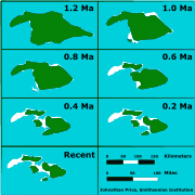 Seven shield volcanoes created the island of Maui Nui
. In Hawaiian, "Nui" means "great" or "large", and Maui
is the name of Hawaii's second largest island (which formed Maui Nui's backbone). At its maximum, about 1.2 million years ago, Maui Nui was 14600 square kilometres (5,637.1 sq mi) in size, 50% larger than the present-day island of Hawaii. Sea levels were lower than today during ice age
s. Subsidence and erosion
caused the "saddles" connecting the volcanoes to flood by 200,000 years ago, forming the islands of Maui, Molokai
, Lānai
, and Kahoolawe
. Penguin Bank
is a former island lying west of Molokai that is completely submerged and now hosts a cap of coral
. The water between these four islands is relatively shallow, about 500 metres (1,640.4 ft) deep. Maui Nui's outer edges plummet quickly to the abyssal plain
. A flank collapse along the steep slopes could produce massive landslides. One prior collapse removed much of the northern half of East Molokai.
provided most of the current knowledge about the drift. The 2001 expedition drilled six seamounts and tested the samples to determine their original latitude
, and thus the characteristics and speed of the hotspot's drift pattern in total.
 Each successive volcano spends less time actively attached to the plume. The large difference between the youngest and oldest lavas between Emperor and Hawaiian volcanoes indicates that the hotspot's velocity is increasing. For example, Kohala
, the oldest volcano on Hawaii island, emerged from the sea 500,000 years ago, and last erupted 120,000 years ago, a period of only 380,000 years; in comparison to Detroit seamount's (the second oldest in the chain) 18 million or more years of volcanic activity.
 The oldest volcano in the chain, Meiji Seamount, perched on the edge of the Aleutian Trench
, is believed to have formed 82 million years ago. The seamount will be destroyed within a few million years, at its current velocity as the Pacific Plate
slides under the Eurasian Plate
. In 2006, Russian geologists hypothesized that older seamounts have already been destroyed by subduction
.
analysis of the Hawaiian – Emperor seamount chain reveals the hotspot as the center of a topographic
high, and that elevation falls with distance from the hotspot. The most rapid decrease in elevation and the highest ratio between the topography and geoid
height are over the southeastern part of the chain, falling with distance from the hotspot, particularly at the intersection of the Molokai and Murray fracture zones. The most likely explanation is that the region between the two zones is more susceptible to reheating than most of the chain. Another possible explanation is that the hotspot strength swells and subsides over time.
In 1953, Robert S. Dietz
and his colleagues first identified the swell behavior. It was suggested that the cause was mantle upwelling. Later work pointed to tectonic uplift
, caused by reheating within the lower lithosphere. However, normal seismic activity beneath the swell, as well as lack of detected heat flow, caused scientists to suggest a dynamic explanation. Understanding the Hawaiian swell has important implications for hotspot study, island formation, and inner Earth.
is about 0.02 km³ (0.00479825517208573 cu mi) for every 1000 kilometres (621 mi) of ridge. The rate along the Emperor seamount chain averaged about 0.01 cubic kilometre (0.00239912758604287 cu mi) per year. The rate was almost zero for the initial five million or so years in the hotspot's life. The average lava production rate along the Hawaiian chain has been greater, at 0.017 km³ (0.00407851689627287 cu mi) per year.
In addition, the distance between volcanoes shrink towards the newer end. Many of the volcanoes in the Emperor seamounts are separated by 100 kilometres (62 mi) or even as much as 200 kilometres (124 mi).
–niobium
–palladium
elemental
ratio. Emperor data represents 43 million years of activity, with the oldest lava dated to the late Mesozoic Era (Cretaceous Period) and the youngest to the early Cenozoic Era (Paleogene Period). This leads to the modern day with the eruptions on Loihi and Kīlauea, another 39 million years of activity, totaling 82 million years. Data demonstrate a large upward variation in the amount of strontium present in both the alkalic (early stages) and tholeitic (later stages) lavas. The systematic increase slows drastically at the time of the bend. The change is partially associated with the thinning of the local plate as the hotspot and the Pacific Plate separated.
 Almost all magma
created by the hotspot is igneous
basalt
; the volcanoes are constructed almost entirely of this or the similar, coarse-grained gabbro
and diabase
. Rarely, there are different igneous rocks, such as nephelinite
; these occur often on the older volcanoes, most prominently Detroit Seamount. Most eruptions are runny because basaltic magma is more fluid than magmas typical in more explosive eruption
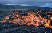
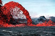
s such as the andesitic magmas that produce spectacular and dangerous eruptions around Pacific Basin margins. Volcanoes fall into several eruptive categories. Hawaiian volcanoes are called "Hawaiian-type". Hawaiian lava spills out of craters and forms long streams of glowing molten rock, flowing down the slope, covering acres of land and replacing ocean with new land.
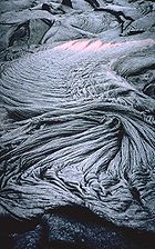
Hawaiian volcanoes produce predominantly two lava types, pāhoehoe and [[ʻaʻā]]. Pāhoehoe is a highly pliable, thin type of relatively fast-flowing lava. It can appear bulbous, fresh-looking, wrinkled, fibrous, or in some other shape depending on its temperature. ʻAʻā flow, however, is characterized by a jagged, ruffled appearance. It is slightly thicker but can move faster on an incline. The top cools and forms an insulating, jagged shell in the form of large basalt chunks, which insulates the flow and keeps it moving. Occasionally pāhoehoe converts to ʻaʻā while it is cooling or degassing.
Indirect studies found that the magma chamber is located at about 90–100 km (55.9–62.1 mi) which matches the estimated depth of the Cretaceous Period rock in the lithosphere. This seeming coincidence may indicate that the lithosphere acts as a lid on melting by arresting the magma's ascent. The lava's original temperature was tested in two ways:
Both USGS tests seem to confirm the temperature at about 1500 °C (2,732 °F). The olivine test also found that the temperature could not have been greater than 1550 °C (2,822 °F) for the olivine to have retained that amount of clinopyroxene. The garnet test agreed, putting the temperature range at 1500 °C (2,732 °F) to 1560 °C (2,840 °F). In comparison, the estimated temperature for mid-ocean ridge basalt is about 1325 °C (2,417 °F).
 Hawaiian eruption
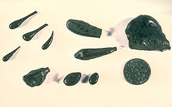
s can produce Pele's hair
, which are brownish threads of volcanic glass
with a diameter of less than 0.5 millimetre (0.0196850393700787 in), and may be as long as 2 metres (7 ft). The strands form when molten lava is overstretched; for example, when an ʻaʻā flow runs off a steep cliff. Pele's hair is often carried high into the air during eruptions. Wind can blow the glass threads tens of kilometers from their place of origin.
Pele's tears
are small droplet-shaped bits of volcanic glass ejecta, which form when small fragments of molten lava cool exceptionally quickly. Pele's tears are often black, and sometimes form on the tips of Pele's hair.
Pele's seaweed are sheets of brownish volcanic glass that form when pāhoehoe lava pours into the ocean. Water may become trapped and begin to boil within the lava, creating steam-filled bubbles of lava. As the bubble cools and bursts, the walls shatter and form thin plates of glass which may resemble seaweed.
 Sometimes, molten basaltic lava solidifies around trees, forming "lava trees". The tree is incinerated forming a mold inside the crust. Lava Tree State Monument
is located 2.7 miles (4.3 km) southeast of Pahoa on Hawaii. It preserves molds that formed when a lava flow swept through a forested area in 1790. Tree molds often preserve both the shape and the structure of the tree. They are common in pāhoehoe flows, and occasionally in ʻaʻā. Sometimes, the lava drains away after incinerating the tree, leaving a hole in the ground.
Over time levee
s can develop in pāhoehoe by overflowing the channels, while in ʻaʻā they are caused by moving lava into blocks. These channels can often surround a kipuka
(Hawaiian for "island"), an island of mature vegetation surrounded by barren younger lava. Kipuka form when lava surrounds a particular raised area, leaving its ecosystem intact.
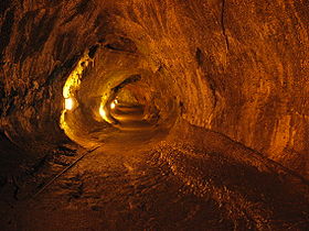 Cooling in a pāhoehoe channel can produce a lava tube
. The surrounding rock acts as an insulator for the interior lava, preventing it from crystallizing. The tube allows lava to travel far from the eruption center, and may allow the lava to flow at higher speeds; a 1984 flow through Mauna Loa was recorded at speeds of over 35 miles per hour (56 km/h). Tubes feature a flat floor and splatter (marking the flow's high point); an example is the Thurston lava tube, part of Hawaii Volcanoes National Park
. Inside the tubes, "lava stalactite
s" occasionally occur. If the chamber refills with lava after draining, it may partially melt the roof of the tube and gravity does the rest. After the roof resolidifies, lava stalactites cling to it. Unlike their mineral counterparts, lava stalactites do not grow after formation.
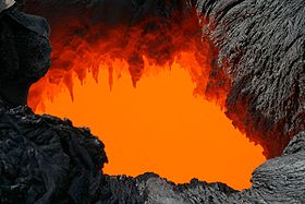
Other structures include: dome lava fountain
s, essentially a hemispheric upwelling of lava; lava lake
s, which are pools of molten lava in a crater or depression (the one at Kīlauea, Kupaianaha, is one of only five active lakes worldwide); some of the highest lava fountain
s on Earth; lava falls (or lava cascade), where lava spills over a cliff or a steep descent; and lava "skylights", which are holes in the roof of a lava tube or underground pools of lava.
 Hawaiian volcanoes follow a well-established life cycle of growth and erosion. After a new volcano forms, its lava output gradually increases. Height and activity both peak at about age 500,000 and then rapidly decline. Eventually it goes dormant, and eventually extinct. Erosion then weathers the volcano until it again becomes a seamount.
This life cycle consists of several stages. The first stage is the submarine preshield stage, currently represented solely by Loihi. During this stage, the volcano builds height through increasingly frequent eruptions. The sea's pressure prevents explosive eruptions. The cold water quickly solidifies the lava, producing the pillow lava
that is typical of underwater volcanic activity.
 As the seamount slowly grows, it goes through the shield stages. It forms many mature features, such as a caldera
while submerged. The summit eventually breaches the surface, and the lava and ocean water "battle" for control as the volcano enters the explosive subphase. This stage of development is exemplified by explosive steam vents. This stage produces mostly volcanic ash
, a result of the waves dampening the lava. This conflict between lava and sea influences Hawaiian mythology
.
The volcano enters the subaerial subphase once it is tall enough to escape the water. Now the volcano puts on 95% of its above-water height over roughly 500,000 years. Thereafter eruptions become much less explosive. The lava released in this stage often includes both pāhoehoe and ʻaʻā. The most impressive Hawaiian volcanoes, Mauna Loa and Kīlauea, are in this phase. Because of the high growth rate, landslide
s are common. Hawaiian lava is often runny, blocky, slow, and relatively easy to predict; the USGS tracks where it is most likely to run, and maintains a tourist site for viewing the lava. Kīlauea has erupted continuously since 1986 through Puʻu ʻŌʻō, a minor volcanic cone, which as become an attraction for vulcanologists and tourists alike.
After the subaerial phase the volcano enters an erosive series of postshield stages, becoming an atoll
and eventually a seamount (or often a guyot
). Once the Pacific Plate moves it out of the 20 °C (68 °F) tropics, the reef mostly dies away, and the extinct volcano becomes one of an estimated 10,000 barren seamounts worldwide. Every Emperor seamount is a dead volcano.
, which comprises most of the U.S. state of Hawaii and is the location of all modern volcanic activity; the Northwestern Hawaiian Islands
, which consist of coral atoll
s, extinct island
s, and atoll island
s; and the Emperor Seamounts, all of which have since eroded and subsided
to the sea and become seamounts and guyot
s (flat-topped seamounts).
Hotspot (geology)
The places known as hotspots or hot spots in geology are volcanic regions thought to be fed by underlying mantle that is anomalously hot compared with the mantle elsewhere. They may be on, near to, or far from tectonic plate boundaries. There are two hypotheses to explain them...
that created the Hawaiian Islands
Hawaiian Islands
The Hawaiian Islands are an archipelago of eight major islands, several atolls, numerous smaller islets, and undersea seamounts in the North Pacific Ocean, extending some 1,500 miles from the island of Hawaii in the south to northernmost Kure Atoll...
in the central Pacific Ocean
Pacific Ocean
The Pacific Ocean is the largest of the Earth's oceanic divisions. It extends from the Arctic in the north to the Southern Ocean in the south, bounded by Asia and Australia in the west, and the Americas in the east.At 165.2 million square kilometres in area, this largest division of the World...
, and is one of Earth
Earth
Earth is the third planet from the Sun, and the densest and fifth-largest of the eight planets in the Solar System. It is also the largest of the Solar System's four terrestrial planets...
's best-known and most heavily-studied hotspots.
While most volcanic activity occurs along tectonic plate boundaries, powered by the plates' movement, hotspots can occur far from such geological boundaries, so that a different model, involving unusual features in the Earth's lithosphere
Lithosphere
The lithosphere is the rigid outermost shell of a rocky planet. On Earth, it comprises the crust and the portion of the upper mantle that behaves elastically on time scales of thousands of years or greater.- Earth's lithosphere :...
, is required.
Seafloor spreading
Seafloor spreading
Seafloor spreading is a process that occurs at mid-ocean ridges, where new oceanic crust is formed through volcanic activity and then gradually moves away from the ridge. Seafloor spreading helps explain continental drift in the theory of plate tectonics....
pulls Hawaii's volcanoes northwest about 10 centimetres (3.9 in) a year, so that 30 million years ago, the Kure
Kure Atoll
Kure Atoll or Ocean Island is an atoll in the Pacific Ocean beyond Midway Atoll in the Northwestern Hawaiian Islands at . The only land of significant size is called Green Island and is habitat for hundreds of thousands of seabirds...
and Midway atoll
Midway Atoll
Midway Atoll is a atoll in the North Pacific Ocean, near the northwestern end of the Hawaiian archipelago, about one-third of the way between Honolulu, Hawaii, and Tokyo, Japan. Unique among the Hawaiian islands, Midway observes UTC-11 , eleven hours behind Coordinated Universal Time and one hour...
s were located where the island of Hawai'i is now. The oldest extant volcano in the chain, Meiji Seamount
Meiji Seamount
Meiji Seamount is the oldest seamount in the Hawaiian-Emperor seamount chain, with an estimated age of 82 million years. It lies at the northernmost end of the chain, and is perched at the outer slope of the Kuril-Kamchatka Trench...
, began to form 86 million years ago; the hotspot may be older, however, since subduction
Subduction
In geology, subduction is the process that takes place at convergent boundaries by which one tectonic plate moves under another tectonic plate, sinking into the Earth's mantle, as the plates converge. These 3D regions of mantle downwellings are known as "Subduction Zones"...
of tectonic plates on the margin between the Pacific
Pacific Plate
The Pacific Plate is an oceanic tectonic plate that lies beneath the Pacific Ocean. At 103 million square kilometres, it is the largest tectonic plate....
and Eurasian plate
Eurasian Plate
The Eurasian Plate is a tectonic plate which includes most of the continent of Eurasia , with the notable exceptions of the Indian subcontinent, the Arabian subcontinent, and the area east of the Chersky Range in East Siberia...
s may have destroyed older volcanoes.
The Hawaii hotspot has created the Hawaiian – Emperor seamount chain comprising at least 129 volcanoes arranged in a line with a sharp bend. More than 123 of these are extinct volcanoes, seamount
Seamount
A seamount is a mountain rising from the ocean seafloor that does not reach to the water's surface , and thus is not an island. These are typically formed from extinct volcanoes, that rise abruptly and are usually found rising from a seafloor of depth. They are defined by oceanographers as...
s, and atoll
Atoll
An atoll is a coral island that encircles a lagoon partially or completely.- Usage :The word atoll comes from the Dhivehi word atholhu OED...
s, four are active volcanoes, and two are dormant volcanoes. Hawaiian volcanoes range in age from 300,000 to 86 million years, progressing from southeast to northwest. This chain includes the Hawaiian Ridge, consisting of the islands of the Hawaiian chain northwest to Kure Atoll
Kure Atoll
Kure Atoll or Ocean Island is an atoll in the Pacific Ocean beyond Midway Atoll in the Northwestern Hawaiian Islands at . The only land of significant size is called Green Island and is habitat for hundreds of thousands of seabirds...
, and the Emperor seamounts, a linear region of islands, seamounts, atolls, shallows, banks, and reefs along a line trending southeast to northwest beneath the southern Pacific Ocean. The chain stretches over 5800 kilometres (3,604 mi) from the Aleutian Trench
Aleutian Trench
The Aleutian Trench is a subduction zone and oceanic trench which runs along the southern coastline of Alaska and the adjacent waters of northeastern Siberia off the coast of Kamchatka Peninsula. It is classified as a "marginal trench" in the east as it runs along the margin of the continent, and...
in the far northwest Pacific to Lōihi Seamount
Loihi Seamount
Lōihi Seamount is an active undersea volcano located around off the southeast coast of the island of Hawaii about below sea level. It lies on the flank of Mauna Loa, the largest shield volcano on Earth...
, the youngest volcano in the chain, lying about 35 kilometres (22 mi) southeast of the Island of Hawai'i.
A bend corresponding to rocks between 41 and 43 million years old, sharply divides the Hawaiian and Emperor sections. The bend is now thought to result from movement of the hotspot, superseding the theory of a relatively sudden change in the direction of plate motion.
Ancient Hawaiian fishermen were the first to recognize the increasing age of the islands towards the northwest, noting that they were ever more heavily eroded as one progressed in that direction. James Dwight Dana
James Dwight Dana
James Dwight Dana was an American geologist, mineralogist and zoologist. He made pioneering studies of mountain-building, volcanic activity, and the origin and structure of continents and oceans around the world.-Early life and career:...
directed the earliest formal geological study, from 1880 to 1881, and first confirmed the relationship between age and location, again based on erosion. In 1912, geologist Thomas Jaggar
Thomas Jaggar
Thomas Augustus Jaggar, Jr. was an American volcanologist. He founded the Hawaiian Volcano Observatory and directed it from 1912 to 1940.-Biography:...
founded the Hawaiian Volcano Observatory
Hawaiian Volcano Observatory
The Hawaiian Volcano Observatory is a volcano observatory located at Uwekahuna Bluff on the rim of Kīlauea Caldera on the Island of Hawaii. The observatory monitors four active Hawaiian volcanoes: Kīlauea, Mauna Loa, Hualālai, and Haleakalā...
, initiating continuous scientific volcano observation on the island of Hawai'i. The model for the evolution of Hawaiian volcanoes
Evolution of Hawaiian volcanoes
The fifteen volcanoes that make up the eight principal islands of Hawaii are the youngest in a chain of more than 129 volcanoes that stretch across the North Pacific Ocean, called the Hawaiian-Emperor seamount chain....
was completed in 1946. J. Tuzo Wilson proposed the hotspot theory in 1963, using the Hawaii island chain data. In the 1970s, the project of mapping Hawaii's seafloor was undertaken in the continuing effort to gain more information regarding the area's complex geology
Geology
Geology is the science comprising the study of solid Earth, the rocks of which it is composed, and the processes by which it evolves. Geology gives insight into the history of the Earth, as it provides the primary evidence for plate tectonics, the evolutionary history of life, and past climates...
.
Hotspot theory
Tectonic platesTectonic Plates
Tectonic Plates is a 1992 independent Canadian film directed by Peter Mettler. Mettler also wrote the screenplay based on the play by Robert Lepage. The film stars Marie Gignac, Céline Bonnier and Robert Lepage.-Plot summary:...
generally focus deformation and volcanism at plate boundaries. However, the Hawaii hotspot is more than 3200 kilometres (1,988 mi) from the nearest plate boundary. In 1963, Canadian geophysicist J. Tuzo Wilson proposed the hotspot theory
Theory
The English word theory was derived from a technical term in Ancient Greek philosophy. The word theoria, , meant "a looking at, viewing, beholding", and referring to contemplation or speculation, as opposed to action...
to explain how these zones of deformation and volcanism form in plate interiors.
Wilson's stationary hotspot theory
Wilson claimed that certain small, long lasting, exceptionally hot areas of magma are located under the Earth's surface, create localized heat and energy systems, known as thermal or mantle plumeMantle plume
A mantle plume is a hypothetical thermal diapir of abnormally hot rock that nucleates at the core-mantle boundary and rises through the Earth's mantle. Such plumes were invoked in 1971 to explain volcanic regions that were not thought to be explicable by the then-new theory of plate tectonics. Some...
s, that sustain long-lasting volcanic activity. This "mid-plate volcanism" builds mountains that rise from the relatively featureless sea floor, initially as seamount
Seamount
A seamount is a mountain rising from the ocean seafloor that does not reach to the water's surface , and thus is not an island. These are typically formed from extinct volcanoes, that rise abruptly and are usually found rising from a seafloor of depth. They are defined by oceanographers as...
s, which eventually rise above the surface, forming volcanic islands. The hotspot remains relatively stationary, as Earth's tectonic plates slide over it, carrying the volcanoes with them. When the magma supply is cut by the plate's motion and the volcano becomes extinct, the island eventually erodes below the waves, again becoming a seamount. Meanwhile, a new volcano forms over the hotspot, forming another new island. The process continues until the mantle plume collapses.
According to Wilson, the Hawaiian chain's volcanoes should be progressively older and increasingly eroded northwestward from the hotspot. The oldest rocks in the main Hawaiian islands, the rocks on Kauai
Kauai
Kauai or Kauai, known as Tauai in the ancient Kaua'i dialect, is geologically the oldest of the main Hawaiian Islands. With an area of , it is the fourth largest of the main islands in the Hawaiian archipelago, and the 21st largest island in the United States. Known also as the "Garden Isle",...
, are about 5.5 million years old and deeply eroded. In contrast, the rocks of the "Big Island
Hawaii (island)
The Island of Hawaii, also called the Big Island or Hawaii Island , is a volcanic island in the North Pacific Ocean...
", and those of Loihi, are under 0.7 million years old. New lava is constantly emitted from the Kilauea caldera
Caldera
A caldera is a cauldron-like volcanic feature usually formed by the collapse of land following a volcanic eruption, such as the one at Yellowstone National Park in the US. They are sometimes confused with volcanic craters...
on Hawaii's Big Island.
Pacific Plate
The Pacific Plate is an oceanic tectonic plate that lies beneath the Pacific Ocean. At 103 million square kilometres, it is the largest tectonic plate....
's movement. Approximately 40–50 million years ago, it is thought to have suddenly changed direction, because of the subduction of the spreading ridge separating the Pacific and Izanagi plate
Izanagi Plate
The Izanagi Plate was an ancient tectonic plate, which began subducting beneath the Okhotsk section of the North American Plate during 130 - 100 Ma. The rapid plate motion of the Izanagi Plate caused the northward drift of north-west Japan and the outer zone of south-west Japan...
s, and the initiation of subduction along much of the Pacific Plate's western boundary. The change in direction was marked by an L-shaped bend in the seamount chain, easily visible in raised-relief map
Raised-relief map
A raised-relief map or terrain model is a three-dimensional representation, usually of terrain. When representing terrain, the elevation dimension is usually exaggerated by a factor between five and ten; this facilitates the visual recognition of terrain features.-History:In his 1665 paper for the...
s. However, this part of the theory has recently been challenged, and the bend might be attributed to the movement of the hotspot itself.
Geophysicists generally believe that hotspots originate at one of two major boundaries deep in the Earth. The shallow option is an interface in the lower mantle
Mantle (geology)
The mantle is a part of a terrestrial planet or other rocky body large enough to have differentiation by density. The interior of the Earth, similar to the other terrestrial planets, is chemically divided into layers. The mantle is a highly viscous layer between the crust and the outer core....
between an upper convecting
Mantle convection
Mantle convection is the slow creeping motion of Earth's rocky mantle caused by convection currents carrying heat from the interior of the Earth to the surface. The Earth's surface lithosphere, which rides atop the asthenosphere , is divided into a number of plates that are continuously being...
layer and a lower non-convecting layer. The deeper option is the D
Core-mantle boundary
The core–mantle boundary lies between the Earth's silicate mantle and its liquid iron-nickel outer core. This boundary is located at approximately 2900 km of depth beneath the Earth's surface. The boundary is observed via the discontinuity in seismic wave velocities at that depth...
. A mantle plume
Mantle plume
A mantle plume is a hypothetical thermal diapir of abnormally hot rock that nucleates at the core-mantle boundary and rises through the Earth's mantle. Such plumes were invoked in 1971 to explain volcanic regions that were not thought to be explicable by the then-new theory of plate tectonics. Some...
would initiate at the interface when the warmer lower layer heats a portion of the cooler upper layer. This heated, buoyant, and less-viscous
Viscosity
Viscosity is a measure of the resistance of a fluid which is being deformed by either shear or tensile stress. In everyday terms , viscosity is "thickness" or "internal friction". Thus, water is "thin", having a lower viscosity, while honey is "thick", having a higher viscosity...
portion of the upper layer would become less dense due to thermal expansion
Thermal expansion
Thermal expansion is the tendency of matter to change in volume in response to a change in temperature.When a substance is heated, its particles begin moving more and thus usually maintain a greater average separation. Materials which contract with increasing temperature are rare; this effect is...
, and rise towards the surface as a Rayleigh-Taylor instability
Rayleigh-Taylor instability
The Rayleigh–Taylor instability, or RT instability , is an instability of an interface between two fluids of different densities, which occurs when the lighter fluid is pushing the heavier fluid....
or gravitational instability. When the mantle plume reaches the base of the lithosphere
Lithosphere
The lithosphere is the rigid outermost shell of a rocky planet. On Earth, it comprises the crust and the portion of the upper mantle that behaves elastically on time scales of thousands of years or greater.- Earth's lithosphere :...
, the plume heats it and produces melt. This magma
Magma
Magma is a mixture of molten rock, volatiles and solids that is found beneath the surface of the Earth, and is expected to exist on other terrestrial planets. Besides molten rock, magma may also contain suspended crystals and dissolved gas and sometimes also gas bubbles. Magma often collects in...
then makes its way to the surface, where it is erupted as lava
Lava
Lava refers both to molten rock expelled by a volcano during an eruption and the resulting rock after solidification and cooling. This molten rock is formed in the interior of some planets, including Earth, and some of their satellites. When first erupted from a volcanic vent, lava is a liquid at...
.
Arguments for the validity of the hotspot theory generally center on:
- The steady age progression of the Hawaiian islands and other seamount chains.
- Just south of the Hawaiian – Emperor chain, the Austral–Marshall Islands seamount chain shows a similar bend in the trail of the Macdonald hotspotMacdonald hotspotThe Macdonald hotspot is a volcanic hotspot in the southern Pacific Ocean. The hotspot was responsible for the formation of the Macdonald Seamount, and possibly the Austral-Cook Islands chain. It is named after Gordon Macdonald....
. - Other proposed hotspots (the MarquesasMarquesas hotspotThe Marquesas hotspot is a volcanic hotspot in the central Pacific Ocean. It is responsible for the Marquesas Islands, a group of 12 volcanic islands and one of the five archipelagos of French Polynesia....
, SocietySociety hotspotThe Society hotspot is a volcanic hotspot located in the Pacific Ocean, and is responsible for the creation of the Society Islands....
, PitcairnPitcairn hotspotThe Pitcairn hotspot is a volcanic hotspot located in the south-central Pacific Ocean. It is responsible for creating the Pitcairn Islands and two large seamounts called Adams and Bounty....
, SamoaSamoa hotspotThe Samoa hotspot is a volcanic hotspot located in the south Pacific Ocean.In geology the Hotspot model describes a hot upwelling plume of molten magma through the Earth's crust as an explanation of how volcanic islands are formed. The hotspot idea came from J...
and Macdonald hotspotMacdonald hotspotThe Macdonald hotspot is a volcanic hotspot in the southern Pacific Ocean. The hotspot was responsible for the formation of the Macdonald Seamount, and possibly the Austral-Cook Islands chain. It is named after Gordon Macdonald....
s) within the Pacific Basin, follow the same age-progressed trend from southeast to northwest, remaining in fixed relative positions. - Seismology studies of Hawaii seem to show increased temperatures down to the core–mantle boundary, suggesting evidence of a plume.
Shallow hotspot theory
Another theory hypothesizes that hotspots are born from shallow tectonic interactions between the lithosphereLithosphere
The lithosphere is the rigid outermost shell of a rocky planet. On Earth, it comprises the crust and the portion of the upper mantle that behaves elastically on time scales of thousands of years or greater.- Earth's lithosphere :...
and asthenosphere
Asthenosphere
The asthenosphere is the highly viscous, mechanically weak and ductilely-deforming region of the upper mantle of the Earth...
. Because of shifting plate boundaries, the area around Hawaii was vastly different 70–100 million years ago, and there may have been a spreading ridge (the Pacific–Kula Ridge
Pacific-Kula Ridge
The Pacific–Kula Ridge is a former mid-ocean ridge that existed between the Pacific and Kula plates in the Pacific Ocean during the early Tertiary period. Its appearance was in an east-west direction and the Hawaiian-Emperor seamount chain had its attribution with the ridge...
) in the area that disappeared in the early Tertiary
Tertiary
The Tertiary is a deprecated term for a geologic period 65 million to 2.6 million years ago. The Tertiary covered the time span between the superseded Secondary period and the Quaternary...
period, about 65 million years ago. After changing plate dynamics moved the ridge away, the area may have established a continuing magma supply, thus forming a self-sustaining hotspot, possibly tapping into deeper mantle processes.
However, seismic tomography
Seismic tomography
Seismic tomography is a methodology for estimating the Earth's properties. In the seismology community, seismic tomography is just a part of seismic imaging, and usually has a more specific purpose to estimate properties such as propagating velocities of compressional waves and shear waves . It...
rejects this hypothesis, as it shows that the plume beneath the Hawaii hotspot extends to the core–mantle boundary
Core–mantle boundary
The core–mantle boundary lies between the Earth's silicate mantle and its liquid iron-nickel outer core. This boundary is located at approximately 2900 km of depth beneath the Earth's surface. The boundary is observed via the discontinuity in seismic wave velocities at that depth...
.
Moving hotspot theory
The most disputed element of the theory is whether or not hotspots are fixed relative to the overlying tectonic plates, and to each other. Drill samplesCore sample
A core sample is a cylindrical section of a naturally occurring substance. Most core samples are obtained by drilling with special drills into the substance, for example sediment or rock, with a hollow steel tube called a core drill. The hole made for the core sample is called the "core hole". A...
, collected by scientists as far back as 1963, suggested that the hotspot may have drifted over time, at the relatively rapid pace of about 4 centimetres (1.6 in) per year during the late Cretaceous
Cretaceous
The Cretaceous , derived from the Latin "creta" , usually abbreviated K for its German translation Kreide , is a geologic period and system from circa to million years ago. In the geologic timescale, the Cretaceous follows the Jurassic period and is followed by the Paleogene period of the...
and early Paleogene
Paleogene
The Paleogene is a geologic period and system that began 65.5 ± 0.3 and ended 23.03 ± 0.05 million years ago and comprises the first part of the Cenozoic Era...
times (81-47 Mya). In 1987, Peter Molnar and Joann Stock found that the hotspot does move, at least relative to the Atlantic Ocean. However, this was believed to be a result of the relative motions of the North American
North American Plate
The North American Plate is a tectonic plate covering most of North America, Greenland, Cuba, Bahamas, and parts of Siberia, Japan and Iceland. It extends eastward to the Mid-Atlantic Ridge and westward to the Chersky Range in eastern Siberia. The plate includes both continental and oceanic crust...
and Pacific plates rather than the hotspot itself.
The Ocean Drilling Program
Ocean Drilling Program
The Ocean Drilling Program was an international cooperative effort to explore and study the composition and structure of the Earth's ocean basins. ODP, which began in 1985, was the direct successor to the highly successful Deep Sea Drilling Project initiated in 1968 by the United States...
(ODP) is an international research effort designed to study the world's seafloors. In 2001, ODP funded a two-month excursion aboard the research vessel JOIDES Resolution to collect lava samples from four submerged Emperor seamounts. The project drilled Detroit
Detroit Seamount
Detroit Seamount, which was formed around 76 million years ago, is one of the oldest seamounts of the Hawaiian-Emperor seamount chain...
, Nintoku
Nintoku Seamount
Nintoku Seamount or Nintoku Guyot is a seamount and guyot in the Hawaiian-Emperor seamount chain. It is a large, irregularly shaped volcano that last erupted 65 million years ago. Three lava flows have been sampled at Nintoku Seamount; the flows are almost all alkalic lava...
, and Koko seamounts, all of which are in the far northwest end of the chain, the oldest section.
In 2003, a study used those lava samples to test the hotspot theory's validity. The findings suggested that the bend was caused by the motion of the Hawaiian hotspot itself.
The Emperor and Hawaiian chains differ in orientation by about 60°, and it has long been assumed that a major change in plate movement caused the bend; but new evidence suggests this did not occur. The change in direction was never recorded by magnetic declination
Magnetic declination
Magnetic declination is the angle between magnetic north and true north. The declination is positive when the magnetic north is east of true north. The term magnetic variation is a synonym, and is more often used in navigation...
s, fracture zone
Fracture zone
A fracture zone is a linear oceanic feature--often hundreds, even thousands of kilometers long--resulting from the action of offset mid-ocean ridge axis segments. They are a consequence of plate tectonics. Lithospheric plates on either side of an active transform fault move in opposite directions;...
orientations or plate reconstruction
Plate reconstruction
Plate reconstruction is the process of reconstructing the positions of tectonic plates relative to each other or to other reference frames, such as the earth's magnetic field or groups of hotspots, in the geological past...
s. Also, a continental collision
Continental collision
Continental collision is a phenomenon of the plate tectonics of Earth that occurs at convergent boundaries. Continental collision is a variation on the fundamental process of subduction, whereby the subduction zone is destroyed, mountains produced, and two continents sutured together...
would not have been fast enough to have produced such a pronounced bend in the chain.
To test whether or not the bend was a result of a change in direction of the Pacific Plate, scientists analyzed the lava samples' geochemistry to determine where and when they formed. Age was determined by the radiometric dating
Radiometric dating
Radiometric dating is a technique used to date materials such as rocks, usually based on a comparison between the observed abundance of a naturally occurring radioactive isotope and its decay products, using known decay rates...
of radioactive isotopes of potassium
Potassium
Potassium is the chemical element with the symbol K and atomic number 19. Elemental potassium is a soft silvery-white alkali metal that oxidizes rapidly in air and is very reactive with water, generating sufficient heat to ignite the hydrogen emitted in the reaction.Potassium and sodium are...
and argon
Argon
Argon is a chemical element represented by the symbol Ar. Argon has atomic number 18 and is the third element in group 18 of the periodic table . Argon is the third most common gas in the Earth's atmosphere, at 0.93%, making it more common than carbon dioxide...
. Researchers estimated that the volcanoes formed during a period 81 million to 45 million years ago. Tarduno and his team determined where the volcanoes formed by analyzing the rock for the magnetic mineral magnetite
Magnetite
Magnetite is a ferrimagnetic mineral with chemical formula Fe3O4, one of several iron oxides and a member of the spinel group. The chemical IUPAC name is iron oxide and the common chemical name is ferrous-ferric oxide. The formula for magnetite may also be written as FeO·Fe2O3, which is one part...
. While hot lava from a volcanic eruption cools, tiny grains within the magnetite align with the Earth's magnetic field
Earth's magnetic field
Earth's magnetic field is the magnetic field that extends from the Earth's inner core to where it meets the solar wind, a stream of energetic particles emanating from the Sun...
, and lock in place once the rock solidifies. Researchers were able to verify the latitudes at which the volcanoes formed by measuring the grains' orientation within the magnetite. Paleomagnetists concluded that the Hawaiian hotspot had drifted southward sometime in its history.
The study indicated that 47 million years ago, the hotspot's southward motion greatly slowed, perhaps stopping.
Hawaii hotspot characteristics
The Hawaii hotspot has a number of unique features.- The Hawaii hotspot has been imaged through seismic tomography, and is estimated to be 500 – wide.
- Recent diffraction tomographyDiffraction TomographyDiffraction tomography is an inverse scattering technique used to find the shape of a scattering object by illuminating it with probing waves and recording the reflections. It is based on the diffraction slice theorem and assumes that the scatterer is weak. It is closely related to X-ray tomography....
and high-resolution local tomographyTomographyTomography refers to imaging by sections or sectioning, through the use of any kind of penetrating wave. A device used in tomography is called a tomograph, while the image produced is a tomogram. The method is used in radiology, archaeology, biology, geophysics, oceanography, materials science,...
indicate that under the Hawaiian hotspot, evidence supports a lower-mantle origin of the plume. Plume material ponding beneath the lithosphere is evidenced by a large low-velocity zoneLow-velocity zoneThe low-velocity zone occurs close to the boundary between the lithosphere and the asthenosphere in the upper mantle. It is characterized by unusually low seismic shear wave velocity compared to the surrounding depth intervals. This range of depths also corresponds to anomalously high electrical...
visible in the upper mantle. A thin low-velocity zone extending downward from 670 to 1500 km (416.3 to 932.1 mi) under Hawaii connects with a large low-velocity zone at 2000 km (1,242.7 mi) on the core-mantle boundary to the north of Hawaii, which is interpreted as a tilting mantle plume feeding the hotspot (i.e., the plume is deflected toward the south by mantle flow). - The surface heat flow anomaly around the Hawaiian Swell is only of the order of 10 mW/m2. This is unexpected for the classic model of a hot, buoyant plume in the mantle. However, it has been shown that other plumes display highly variable surface heat fluxes and that this variability may be due to variable hydrothermal fluid flow in the Earth's crust above the hotspots. This fluid flow advectively removes heat from the crust, and the measured conductive heat flow is therefore lower than the true total surface heat flux.
- The low heat across the Hawaiian Swell indicates that it must be supported not by thermal buoyancy, but rather by the existence of a buoyant mass underneath the swell which causes the surface to rise; this density-driven surface uplift is called "dynamic topographyDynamic topographyThe term dynamic topography is used in geodynamics and oceanography to refer to elevation differences caused by the flow within the Earth's mantle and the ocean water, respectively.-Geodynamics:...
". - The Emperor part of the chain (the oldest entities, especially Meiji SeamountMeiji SeamountMeiji Seamount is the oldest seamount in the Hawaiian-Emperor seamount chain, with an estimated age of 82 million years. It lies at the northernmost end of the chain, and is perched at the outer slope of the Kuril-Kamchatka Trench...
) ends near a bend in the Kuril–Kamchatka TrenchKuril-Kamchatka TrenchThe Kuril–Kamchatka Trench or Kuril Trench is an oceanic trench in the northwest Pacific Ocean. It lies off the southeast coast of Kamchatka and parallels the Kuril Island chain to meet the Japan Trench east of Hokkaido...
, where the seamounts on the Pacific Plate subduct under the Eurasian Plate. , it is unknown whether the seamount chain has been subducting under the Eurasian Plate, and whether the hotspot is older than Meiji Seamount. A collision here may have provided a change in direction of the Pacific Plate, creating the bend in the Kuril–Kamchatka Trench. The relationship between these features is still being investigated. - UraniumUraniumUranium is a silvery-white metallic chemical element in the actinide series of the periodic table, with atomic number 92. It is assigned the chemical symbol U. A uranium atom has 92 protons and 92 electrons, of which 6 are valence electrons...
decay-series disequilibria data in ocean island lavas provide constraints on mantle upwelling velocity, mantle temperatures and the cross-section of mantle upwelling. Uranium decay proceeds via the Uranium series yielding ThoriumThoriumThorium is a natural radioactive chemical element with the symbol Th and atomic number 90. It was discovered in 1828 and named after Thor, the Norse god of thunder....
and ProtactiniumProtactiniumProtactinium is a chemical element with the symbol Pa and atomic number 91. It is a dense, silvery-gray metal which readily reacts with oxygen, water vapor and inorganic acids. It forms various chemical compounds where protactinium is usually present in the oxidation state +5, but can also assume...
(Uranium-238Uranium-238 is the most common isotope of uranium found in nature. It is not fissile, but is a fertile material: it can capture a slow neutron and after two beta decays become fissile plutonium-239...
– – – – – ). When frozen into rock for more than a few hundred thousand years, the isotopes reach equilibrium and the activity ratios for the various isotopes (e.g., /) are equal. However the melting process fractionates the elements chemically, upsetting the equilibrium. Disequilibrium indicates a short time has elapsed since fractionation. Based on this data, the predicted Hawaii temperature-excess at the top of the upwelling mantle column is . This data further constrains the actively flowing region of the melt zone to 220 ± 40 km at its base and the width of the upper mantle upwelling to 280 ± 40 km, which is consistent with seismic tomography measurements.
Ancient Hawaiian
Ancient Hawaii
Ancient Hawaii refers to the period of Hawaiian human history preceding the unification of the Kingdom of Hawaii by Kamehameha the Great in 1810. After being first settled by Polynesian long-distance navigators sometime between AD 300–800, a unique culture developed. Diversified agroforestry and...
ans long before Europe
Europe
Europe is, by convention, one of the world's seven continents. Comprising the westernmost peninsula of Eurasia, Europe is generally 'divided' from Asia to its east by the watershed divides of the Ural and Caucasus Mountains, the Ural River, the Caspian and Black Seas, and the waterways connecting...
ans arrived. During their voyages, sea-faring Hawaiians noticed differences in erosion
Erosion
Erosion is when materials are removed from the surface and changed into something else. It only works by hydraulic actions and transport of solids in the natural environment, and leads to the deposition of these materials elsewhere...
, soil formation, and vegetation
Vegetation
Vegetation is a general term for the plant life of a region; it refers to the ground cover provided by plants. It is a general term, without specific reference to particular taxa, life forms, structure, spatial extent, or any other specific botanical or geographic characteristics. It is broader...
, allowing them to deduce that the islands to the northwest (Niihau
Niihau
Niihau or Niihau is the seventh largest of the inhabited Hawaiian Islands in the U.S. state of Hawaii, having an area of . Niihau lies southwest of Kauai across the Kaulakahi Channel. Several intermittent playa lakes provide wetland habitats for the Hawaiian Coot, the Black-winged Stilt, and the...
and Kauai
Kauai
Kauai or Kauai, known as Tauai in the ancient Kaua'i dialect, is geologically the oldest of the main Hawaiian Islands. With an area of , it is the fourth largest of the main islands in the Hawaiian archipelago, and the 21st largest island in the United States. Known also as the "Garden Isle",...
) were older than those to the southeast (Maui and Hawaii). The idea was handed down the generations through the legend of Pele, the fiery Hawaiian Goddess of Volcanoes. This dynamic view contrasted with the static Genesis creation myth taught by Europeans at the time.
Pele was born to the female spirit Haumea, or Hina
Hina (goddess)
Hina is the name of several different goddesses and women in Polynesian mythology. In some traditions, the trickster and culture hero Maui has a wife named Hina, as do the gods Tane and Tangaroa. Hina is often associated with the moon....
, who, like all Hawaiian gods and goddesses, descended from the supreme beings, Papa, or Earth Mother, and Wakea
Wakea
In Hawaiian mythology, Wākea is the eldest son of Kahiko , and lives in Olalowaia. Wākea is the ancestor of the aristocracy, the ali‘i. The priests and common people come from his brothers. In another legend, Wākea lives in Hihiku and marries Pāpā, also called Pāpā-nui or Pāpā-nui-hanau-moku, who...
, or Sky Father
Sky father
The sky father or heavenly father is a recurring theme in mythology all over the world. The sky father is the complement of the earth mother and appears in some creation myths, many of which are Indo-European or ancient Near Eastern. Other cultures have quite different myths; Egyptian mythology...
. According to the myth, Pele originally lived on Kauai, when her older sister Nāmaka
Namaka
In Hawaiian mythology, Nāmaka appears as a sea goddess or a water spirit in the Pele cycle. She is an older sister of Pele-honua-mea. She is the daughter of Ku-waha-ilo and Haumea, whose other children are Pele, the Hiiaka sisters, the Kama brothers, and the bird Halulu...
, the Goddess of the Sea, attacked her for seducing her husband. Pele fled southeast to the island of Oahu. When forced by Nāmaka
Namaka
In Hawaiian mythology, Nāmaka appears as a sea goddess or a water spirit in the Pele cycle. She is an older sister of Pele-honua-mea. She is the daughter of Ku-waha-ilo and Haumea, whose other children are Pele, the Hiiaka sisters, the Kama brothers, and the bird Halulu...
to flee again, Pele moved southeast to Maui and finally to Hawaii, where she still lives in the Halemaumau Crater
Halemaumau Crater
Halemaumau crater is a pit crater located within the much larger summit caldera of Kīlauea in Hawaii Volcanoes National Park. The roughly circular crater floor is x and is below the floor of Kīlauea caldera, located at coordinates . Halemaumau is home to Pele, Goddess of Hawaiian Volcanoes,...
at the summit of Kīlauea
Kilauea
Kīlauea is a volcano in the Hawaiian Islands, and one of five shield volcanoes that together form the island of Hawaii. Kīlauea means "spewing" or "much spreading" in the Hawaiian language, referring to its frequent outpouring of lava. The Puu Ōō cone has been continuously erupting in the eastern...
. There she was safe, because the slopes of the volcano are so high that even Nāmaka's mighty waves could not reach her. Pele's mythical flight, which alludes to an eternal struggle between volcanic islands and ocean waves, is consistent with geologic evidence about the ages of the islands decreasing to the southeast.
Modern studies
Three of the earliest recorded observers of the volcanoes were the ScottishScottish people
The Scottish people , or Scots, are a nation and ethnic group native to Scotland. Historically they emerged from an amalgamation of the Picts and Gaels, incorporating neighbouring Britons to the south as well as invading Germanic peoples such as the Anglo-Saxons and the Norse.In modern use,...
scientists Archibald Menzies
Archibald Menzies
Archibald Menzies was a Scottish surgeon, botanist and naturalist.- Life and career :Menzies was born at Easter Stix in the parish of Weem, in Perthshire. While working with his elder brother William at the Royal Botanic Gardens, he drew the attention of Dr John Hope, professor of botany at...
in 1794, James Macrae
James Macrae
James Macrae was a Scottish seaman and administrator who served as the President of Fort St George from 1725 to 1730. He is known for naval exploits against the pirate Edward England and for reforming the administration of Madras Presidency....
in 1825, and David Douglas
David Douglas
David Douglas was a Scottish botanist. He worked as a gardener, and explored the Scottish Highlands, North America, and Hawaii, where he died.-Early life:...
in 1834. Just reaching the summits proved daunting: Menzies took three attempts to ascend Mauna Loa
Mauna Loa
Mauna Loa is one of five volcanoes that form the Island of Hawaii in the U.S. state of Hawaii in the Pacific Ocean, and the largest on Earth in terms of volume and area covered. It is an active shield volcano, with a volume estimated at approximately , although its peak is about lower than that...
, and Douglas died on the slopes of Mauna Kea
Mauna Kea
Mauna Kea is a volcano on the island of Hawaii. Standing above sea level, its peak is the highest point in the state of Hawaii. However, much of the mountain is under water; when measured from its oceanic base, Mauna Kea is over tall—significantly taller than Mount Everest...
.The United States Exploring Expedition
United States Exploring Expedition
The United States Exploring Expedition was an exploring and surveying expedition of the Pacific Ocean and surrounding lands conducted by the United States from 1838 to 1842. The original appointed commanding officer was Commodore Thomas ap Catesby Jones. The voyage was authorized by Congress in...
spent several months studying the islands in 1840–1841. American geologist James Dwight Dana
James Dwight Dana
James Dwight Dana was an American geologist, mineralogist and zoologist. He made pioneering studies of mountain-building, volcanic activity, and the origin and structure of continents and oceans around the world.-Early life and career:...
was on that expedition, as was Lieutenant Charles Wilkes
Charles Wilkes
Charles Wilkes was an American naval officer and explorer. He led the United States Exploring Expedition, 1838-1842 and commanded the ship in the Trent Affair during the American Civil War...
, who spent most of the time leading a team of hundreds that hauled a pendulum
Pendulum
A pendulum is a weight suspended from a pivot so that it can swing freely. When a pendulum is displaced from its resting equilibrium position, it is subject to a restoring force due to gravity that will accelerate it back toward the equilibrium position...
to the summit of Mauna Loa to measure gravity. Dana stayed with missionary Titus Coan
Titus Coan
Titus Coan was an early American Christian Missionary to the Hawaiian Islands.-Early life and family:Titus Coan was born on February 1, 1801 in Killingworth, Connecticut, the son of Gaylord Coan and Tamza Nettleton. In June, 1831, he entered the Auburn Theological Seminary in Auburn, New York, and...
, who would provide decades of first-hand observations. Dana published a short paper in 1852.
Dana remained interested in the origin of the Hawaiian Islands, and directed a more in-depth study in 1880 and 1881. He confirmed that the islands' age increased with their distance from the southeastern-most island by observing differences in their degree of erosion. He also suggested that many other island chains in the Pacific showed a similar general increase in age from southeast to northwest. Dana concluded that the Hawaiian chain consisted of two volcanic strands, located along distinct but parallel curving pathways. He coined the terms "Loa" and "Kea" for the two prominent trends. The Kea trend includes the volcanoes of Kīlauea
Kilauea
Kīlauea is a volcano in the Hawaiian Islands, and one of five shield volcanoes that together form the island of Hawaii. Kīlauea means "spewing" or "much spreading" in the Hawaiian language, referring to its frequent outpouring of lava. The Puu Ōō cone has been continuously erupting in the eastern...
, Mauna Kea
Mauna Kea
Mauna Kea is a volcano on the island of Hawaii. Standing above sea level, its peak is the highest point in the state of Hawaii. However, much of the mountain is under water; when measured from its oceanic base, Mauna Kea is over tall—significantly taller than Mount Everest...
, Kohala
Kohala (mountain)
Kohala is the oldest of five volcanoes that make up the island of Hawaii. Kohala is an estimated one million years old—so old that it experienced, and recorded, a reversal of magnetic field 780,000 years ago. It is believed to have breached sea level more than 500,000 years ago and to...
, Haleakalā
Haleakala
Haleakalā , or the East Maui Volcano, is a massive shield volcano that forms more than 75% of the Hawaiian Island of Maui. The western 25% of the island is formed by the West Maui Mountains.- History :...
, and West Maui. The Loa trend includes Loihi, Mauna Loa
Mauna Loa
Mauna Loa is one of five volcanoes that form the Island of Hawaii in the U.S. state of Hawaii in the Pacific Ocean, and the largest on Earth in terms of volume and area covered. It is an active shield volcano, with a volume estimated at approximately , although its peak is about lower than that...
, Hualālai
Hualalai
Hualālai is a dormant shield volcano on the island of Hawaii in the Hawaiian Islands. It is the third-youngest and the third most active of the five volcanoes that form the island of Hawaii, following Kīlauea and the much larger Mauna Loa, and also the westernmost. Its peak is above sea...
, Kahoolawe
Kahoolawe
Kahoolawe is the smallest of the eight main volcanic islands in the Hawaiian Islands. Kahoolawe is located about seven miles southwest of Maui and also southeast of Lanai, and it is long by wide, with a total land area of . The highest point on Kahoolawe is the crater of Lua Makika at the...
, Lānai
Lanai
Lānai or Lanai is the sixth-largest of the Hawaiian Islands. It is also known as the Pineapple Island because of its past as an island-wide pineapple plantation. The only town is Lānai City, a small settlement....
, and West Molokai
Molokai
Molokai or Molokai is an island in the Hawaiian archipelago. It is 38 by 10 miles in size with a land area of , making it the fifth largest of the main Hawaiian Islands and the 27th largest island in the United States. It lies east of Oahu across the 25-mile wide Kaiwi Channel and north of...
.
Dana proposed that the alignment of the Hawaiian Islands reflected localized volcanic activity along a major fissure zone. Dana's "great fissure" theory served as the working hypothesis for subsequent studies until the mid-20th century. His conclusions were based mostly on the fact that almost all of the Hawaiian volcanoes have two rift zones, but only one is usually active.
Dana's work was followed up by geologist C. E. Dutton's 1884 expedition, who refined and expanded Dana's ideas. Most notably, Dutton established that the island of Hawaii actually harbored five volcanoes, whereas Dana counted three. This is because Dana had originally regarded Kīlauea as a flank vent of Mauna Loa, and Kohala as part of Mauna Kea. Dutton also refined others of Dana's observations, and is credited with the naming of 'a'ā and pāhoehoe-type lavas, although Dana had noted a distinction. Stimulated by Dutton's expedition, Dana returned in 1887, and published many accounts of his expedition in the American Journal of Science
American Journal of Science
The American Journal of Science is the United States of America's longest-running scientific journal, having been published continuously since its conception in 1818 by Professor Benjamin Silliman, who edited and financed it himself...
. In 1890 he published the most detailed manuscript of its day, and remained the definitive guide to Hawaiian volcanism for decades. 1909 saw the publication of two large volumes which extensively quoted from earlier works now out of circulation
Thomas Jaggar
Thomas Augustus Jaggar, Jr. was an American volcanologist. He founded the Hawaiian Volcano Observatory and directed it from 1912 to 1940.-Biography:...
founded the Hawaiian Volcano Observatory
Hawaiian Volcano Observatory
The Hawaiian Volcano Observatory is a volcano observatory located at Uwekahuna Bluff on the rim of Kīlauea Caldera on the Island of Hawaii. The observatory monitors four active Hawaiian volcanoes: Kīlauea, Mauna Loa, Hualālai, and Haleakalā...
. The facility was taken over in 1919 by the National Oceanic and Atmospheric Administration
National Oceanic and Atmospheric Administration
The National Oceanic and Atmospheric Administration , pronounced , like "noah", is a scientific agency within the United States Department of Commerce focused on the conditions of the oceans and the atmosphere...
and in 1924 by the United States Geological Survey
United States Geological Survey
The United States Geological Survey is a scientific agency of the United States government. The scientists of the USGS study the landscape of the United States, its natural resources, and the natural hazards that threaten it. The organization has four major science disciplines, concerning biology,...
(USGS), which marked the start of continuous volcano observation on Hawaii island. The next century was a period of thorough investigation, marked by contributions from many top scientists. The first complete evolutionary model was first formulated in 1946, by USGS geologist and hydrologist Harold T. Stearns. Since that time, advances have enabled the study of previously limited areas of observation (e.g. improved rock dating methods and submarine volcanic stages).
In the 1970s, the Hawaiian seafloor was mapped using ship-based sonar
Sonar
Sonar is a technique that uses sound propagation to navigate, communicate with or detect other vessels...
. Computed SYNBAPS (Synthetic Bathymetric Profiling System) data filled holes between the ship-based sonar bathymetric
Bathymetry
Bathymetry is the study of underwater depth of lake or ocean floors. In other words, bathymetry is the underwater equivalent to hypsometry. The name comes from Greek βαθύς , "deep", and μέτρον , "measure"...
measurements. In 1971, geologist W. Jason Morgan
W. Jason Morgan
William Jason Morgan is an American geophysicist who has made seminal contributions to the theory of plate tectonics and geodynamics...
went to Hawaii and gathered evidence against Dana's theory, which was first challenged in 1967 by geologists Jack Oliver and B. Isaacs.
From 1994 to 1998 Japan's Marine Science and Technology Center mapped Hawaii in detail and studied its ocean floor, making it one of the world's best-studied marine features. The project, a collaboration with USGS and other agencies, utilized manned submersibles, remotely operated underwater vehicles, dredge samples, and core samples.
The Simrad EM300 multibeam side-scanning sonar system collected bathymetry and backscatter
Backscatter
In physics, backscatter is the reflection of waves, particles, or signals back to the direction they came from. It is a diffuse reflection due to scattering, as opposed to specular reflection like a mirror...
data.
Size
The tallest mountain in the Hawaii chain, Mauna Kea, rises 4205 metres (13,796 ft) above mean sea level. Measured from its base on the seafloor, it is the world's tallest mountain, at 10203 metres (33,474.4 ft). Mount EverestMount Everest
Mount Everest is the world's highest mountain, with a peak at above sea level. It is located in the Mahalangur section of the Himalayas. The international boundary runs across the precise summit point...
rises 8848 metres (29,028.9 ft) above sea level. Hawaii is surrounded by a myriad of seamounts; however, they were found to be unconnected to the hotspot and its vulcanism. The hotspot has produced an estimated 750000 cubic kilometres (179,934.6 cu mi) of lava, enough to cover California
California
California is a state located on the West Coast of the United States. It is by far the most populous U.S. state, and the third-largest by land area...
with a layer about 1.5 kilometre (0.93205910497471 mi) thick.
Maui Nui
Maui Nui or Greater Maui, is a modern geologists' name given to a prehistoric Hawaiian Island built from seven shield volcanoes. Nui means "great/large" in the Hawaiian language....
. In Hawaiian, "Nui" means "great" or "large", and Maui
Maui
The island of Maui is the second-largest of the Hawaiian Islands at and is the 17th largest island in the United States. Maui is part of the state of Hawaii and is the largest of Maui County's four islands, bigger than Lānai, Kahoolawe, and Molokai. In 2010, Maui had a population of 144,444,...
is the name of Hawaii's second largest island (which formed Maui Nui's backbone). At its maximum, about 1.2 million years ago, Maui Nui was 14600 square kilometres (5,637.1 sq mi) in size, 50% larger than the present-day island of Hawaii. Sea levels were lower than today during ice age
Ice age
An ice age or, more precisely, glacial age, is a generic geological period of long-term reduction in the temperature of the Earth's surface and atmosphere, resulting in the presence or expansion of continental ice sheets, polar ice sheets and alpine glaciers...
s. Subsidence and erosion
Erosion
Erosion is when materials are removed from the surface and changed into something else. It only works by hydraulic actions and transport of solids in the natural environment, and leads to the deposition of these materials elsewhere...
caused the "saddles" connecting the volcanoes to flood by 200,000 years ago, forming the islands of Maui, Molokai
Molokai
Molokai or Molokai is an island in the Hawaiian archipelago. It is 38 by 10 miles in size with a land area of , making it the fifth largest of the main Hawaiian Islands and the 27th largest island in the United States. It lies east of Oahu across the 25-mile wide Kaiwi Channel and north of...
, Lānai
Lanai
Lānai or Lanai is the sixth-largest of the Hawaiian Islands. It is also known as the Pineapple Island because of its past as an island-wide pineapple plantation. The only town is Lānai City, a small settlement....
, and Kahoolawe
Kahoolawe
Kahoolawe is the smallest of the eight main volcanic islands in the Hawaiian Islands. Kahoolawe is located about seven miles southwest of Maui and also southeast of Lanai, and it is long by wide, with a total land area of . The highest point on Kahoolawe is the crater of Lua Makika at the...
. Penguin Bank
Penguin Bank
Penguin Bank is the name given to a now-submerged shield volcano of the Hawaiian Islands. Its coral-capped remains lay west of the island of Molokai under relatively shallow water...
is a former island lying west of Molokai that is completely submerged and now hosts a cap of coral
Coral
Corals are marine animals in class Anthozoa of phylum Cnidaria typically living in compact colonies of many identical individual "polyps". The group includes the important reef builders that inhabit tropical oceans and secrete calcium carbonate to form a hard skeleton.A coral "head" is a colony of...
. The water between these four islands is relatively shallow, about 500 metres (1,640.4 ft) deep. Maui Nui's outer edges plummet quickly to the abyssal plain
Abyssal plain
An abyssal plain is an underwater plain on the deep ocean floor, usually found at depths between 3000 and 6000 metres. Lying generally between the foot of a continental rise and a mid-ocean ridge, abyssal plains cover more than 50% of the Earth’s surface. They are among the flattest, smoothest...
. A flank collapse along the steep slopes could produce massive landslides. One prior collapse removed much of the northern half of East Molokai.
Movement
Hawaiian volcanoes drift northwest from the hotspot at a rate of about 5–10 cm (2–3.9 in) a year. The hotspot has migrated south by about 800 kilometres (497 mi) relative to the Emperor chain. This conclusion is supported by magnetic studies, which suggest that these seamounts formed at higher latitudes than present-day Hawaii. Prior to the bend, the hotspot migrated an estimated 7 centimetres (2.8 in) per year; the rate of movement changed at the time of the bend to about 9 centimetres (3.5 in) per year. The Ocean Drilling ProgramOcean Drilling Program
The Ocean Drilling Program was an international cooperative effort to explore and study the composition and structure of the Earth's ocean basins. ODP, which began in 1985, was the direct successor to the highly successful Deep Sea Drilling Project initiated in 1968 by the United States...
provided most of the current knowledge about the drift. The 2001 expedition drilled six seamounts and tested the samples to determine their original latitude
Latitude
In geography, the latitude of a location on the Earth is the angular distance of that location south or north of the Equator. The latitude is an angle, and is usually measured in degrees . The equator has a latitude of 0°, the North pole has a latitude of 90° north , and the South pole has a...
, and thus the characteristics and speed of the hotspot's drift pattern in total.
Kohala (mountain)
Kohala is the oldest of five volcanoes that make up the island of Hawaii. Kohala is an estimated one million years old—so old that it experienced, and recorded, a reversal of magnetic field 780,000 years ago. It is believed to have breached sea level more than 500,000 years ago and to...
, the oldest volcano on Hawaii island, emerged from the sea 500,000 years ago, and last erupted 120,000 years ago, a period of only 380,000 years; in comparison to Detroit seamount's (the second oldest in the chain) 18 million or more years of volcanic activity.
Aleutian Trench
The Aleutian Trench is a subduction zone and oceanic trench which runs along the southern coastline of Alaska and the adjacent waters of northeastern Siberia off the coast of Kamchatka Peninsula. It is classified as a "marginal trench" in the east as it runs along the margin of the continent, and...
, is believed to have formed 82 million years ago. The seamount will be destroyed within a few million years, at its current velocity as the Pacific Plate
Pacific Plate
The Pacific Plate is an oceanic tectonic plate that lies beneath the Pacific Ocean. At 103 million square kilometres, it is the largest tectonic plate....
slides under the Eurasian Plate
Eurasian Plate
The Eurasian Plate is a tectonic plate which includes most of the continent of Eurasia , with the notable exceptions of the Indian subcontinent, the Arabian subcontinent, and the area east of the Chersky Range in East Siberia...
. In 2006, Russian geologists hypothesized that older seamounts have already been destroyed by subduction
Subduction
In geology, subduction is the process that takes place at convergent boundaries by which one tectonic plate moves under another tectonic plate, sinking into the Earth's mantle, as the plates converge. These 3D regions of mantle downwellings are known as "Subduction Zones"...
.
Topography and geoid
A detailed topographicTopography
Topography is the study of Earth's surface shape and features or those ofplanets, moons, and asteroids...
analysis of the Hawaiian – Emperor seamount chain reveals the hotspot as the center of a topographic
Topography
Topography is the study of Earth's surface shape and features or those ofplanets, moons, and asteroids...
high, and that elevation falls with distance from the hotspot. The most rapid decrease in elevation and the highest ratio between the topography and geoid
Geoid
The geoid is that equipotential surface which would coincide exactly with the mean ocean surface of the Earth, if the oceans were in equilibrium, at rest , and extended through the continents . According to C.F...
height are over the southeastern part of the chain, falling with distance from the hotspot, particularly at the intersection of the Molokai and Murray fracture zones. The most likely explanation is that the region between the two zones is more susceptible to reheating than most of the chain. Another possible explanation is that the hotspot strength swells and subsides over time.
In 1953, Robert S. Dietz
Robert S. Dietz
Robert Sinclair Dietz was Professor of Geology at Arizona State University. Dietz was a marine geologist, geophysicist and oceanographer who conducted pioneering research along with Harry Hammond Hess concerning seafloor spreading, published as early as 1960–1961...
and his colleagues first identified the swell behavior. It was suggested that the cause was mantle upwelling. Later work pointed to tectonic uplift
Tectonic uplift
Tectonic uplift is a geological process most often caused by plate tectonics which increases elevation. The opposite of uplift is subsidence, which results in a decrease in elevation. Uplift may be orogenic or isostatic.-Orogenic uplift:...
, caused by reheating within the lower lithosphere. However, normal seismic activity beneath the swell, as well as lack of detected heat flow, caused scientists to suggest a dynamic explanation. Understanding the Hawaiian swell has important implications for hotspot study, island formation, and inner Earth.
Eruption frequency and scale
There is significant evidence that lava flow rates have been increasing. Over the last six million years it has been far higher than ever before, at over 0.095 km³ (0.0227917120674072 cu mi) per year. The average for the last million years is even higher, at about 0.21 km³ (0.0503816793069002 cu mi). In comparison, the average production rate at a mid-ocean ridgeMid-ocean ridge
A mid-ocean ridge is a general term for an underwater mountain system that consists of various mountain ranges , typically having a valley known as a rift running along its spine, formed by plate tectonics. This type of oceanic ridge is characteristic of what is known as an oceanic spreading...
is about 0.02 km³ (0.00479825517208573 cu mi) for every 1000 kilometres (621 mi) of ridge. The rate along the Emperor seamount chain averaged about 0.01 cubic kilometre (0.00239912758604287 cu mi) per year. The rate was almost zero for the initial five million or so years in the hotspot's life. The average lava production rate along the Hawaiian chain has been greater, at 0.017 km³ (0.00407851689627287 cu mi) per year.
In addition, the distance between volcanoes shrink towards the newer end. Many of the volcanoes in the Emperor seamounts are separated by 100 kilometres (62 mi) or even as much as 200 kilometres (124 mi).
Lava
The volcanoes' lava composition has changed significantly, according to analysis of the strontiumStrontium
Strontium is a chemical element with the symbol Sr and the atomic number 38. An alkaline earth metal, strontium is a soft silver-white or yellowish metallic element that is highly reactive chemically. The metal turns yellow when exposed to air. It occurs naturally in the minerals celestine and...
–niobium
Niobium
Niobium or columbium , is a chemical element with the symbol Nb and atomic number 41. It's a soft, grey, ductile transition metal, which is often found in the pyrochlore mineral, the main commercial source for niobium, and columbite...
–palladium
Palladium
Palladium is a chemical element with the chemical symbol Pd and an atomic number of 46. It is a rare and lustrous silvery-white metal discovered in 1803 by William Hyde Wollaston. He named it after the asteroid Pallas, which was itself named after the epithet of the Greek goddess Athena, acquired...
elemental
Chemical element
A chemical element is a pure chemical substance consisting of one type of atom distinguished by its atomic number, which is the number of protons in its nucleus. Familiar examples of elements include carbon, oxygen, aluminum, iron, copper, gold, mercury, and lead.As of November 2011, 118 elements...
ratio. Emperor data represents 43 million years of activity, with the oldest lava dated to the late Mesozoic Era (Cretaceous Period) and the youngest to the early Cenozoic Era (Paleogene Period). This leads to the modern day with the eruptions on Loihi and Kīlauea, another 39 million years of activity, totaling 82 million years. Data demonstrate a large upward variation in the amount of strontium present in both the alkalic (early stages) and tholeitic (later stages) lavas. The systematic increase slows drastically at the time of the bend. The change is partially associated with the thinning of the local plate as the hotspot and the Pacific Plate separated.
Magma
Magma is a mixture of molten rock, volatiles and solids that is found beneath the surface of the Earth, and is expected to exist on other terrestrial planets. Besides molten rock, magma may also contain suspended crystals and dissolved gas and sometimes also gas bubbles. Magma often collects in...
created by the hotspot is igneous
Igneous rock
Igneous rock is one of the three main rock types, the others being sedimentary and metamorphic rock. Igneous rock is formed through the cooling and solidification of magma or lava...
basalt
Basalt
Basalt is a common extrusive volcanic rock. It is usually grey to black and fine-grained due to rapid cooling of lava at the surface of a planet. It may be porphyritic containing larger crystals in a fine matrix, or vesicular, or frothy scoria. Unweathered basalt is black or grey...
; the volcanoes are constructed almost entirely of this or the similar, coarse-grained gabbro
Gabbro
Gabbro refers to a large group of dark, coarse-grained, intrusive mafic igneous rocks chemically equivalent to basalt. The rocks are plutonic, formed when molten magma is trapped beneath the Earth's surface and cools into a crystalline mass....
and diabase
Diabase
Diabase or dolerite is a mafic, holocrystalline, subvolcanic rock equivalent to volcanic basalt or plutonic gabbro. In North American usage, the term diabase refers to the fresh rock, whilst elsewhere the term dolerite is used for the fresh rock and diabase refers to altered material...
. Rarely, there are different igneous rocks, such as nephelinite
Nephelinite
Nephelinite is a fine-grained or aphanitic igneous rock made up almost entirely of nepheline and clinopyroxene . If olivine is present, the rock may be classified as an olivine nephelinite. Nephelinite is dark in color and may resemble basalt in hand specimen...
; these occur often on the older volcanoes, most prominently Detroit Seamount. Most eruptions are runny because basaltic magma is more fluid than magmas typical in more explosive eruption
Explosive eruption
An explosive eruption is a volcanic term to describe a violent, explosive type of eruption. Mount St. Helens in 1980 was an example. Such an eruption is driven by gas accumulating under great pressure. Driven by hot rising magma, it interacts with ground water until the pressure increases to the...
s such as the andesitic magmas that produce spectacular and dangerous eruptions around Pacific Basin margins. Volcanoes fall into several eruptive categories. Hawaiian volcanoes are called "Hawaiian-type". Hawaiian lava spills out of craters and forms long streams of glowing molten rock, flowing down the slope, covering acres of land and replacing ocean with new land.
Hawaiian volcanoes produce predominantly two lava types, pāhoehoe and [[ʻaʻā]]. Pāhoehoe is a highly pliable, thin type of relatively fast-flowing lava. It can appear bulbous, fresh-looking, wrinkled, fibrous, or in some other shape depending on its temperature. ʻAʻā flow, however, is characterized by a jagged, ruffled appearance. It is slightly thicker but can move faster on an incline. The top cools and forms an insulating, jagged shell in the form of large basalt chunks, which insulates the flow and keeps it moving. Occasionally pāhoehoe converts to ʻaʻā while it is cooling or degassing.
Indirect studies found that the magma chamber is located at about 90–100 km (55.9–62.1 mi) which matches the estimated depth of the Cretaceous Period rock in the lithosphere. This seeming coincidence may indicate that the lithosphere acts as a lid on melting by arresting the magma's ascent. The lava's original temperature was tested in two ways:
- testing garnetGarnetThe garnet group includes a group of minerals that have been used since the Bronze Age as gemstones and abrasives. The name "garnet" may come from either the Middle English word gernet meaning 'dark red', or the Latin granatus , possibly a reference to the Punica granatum , a plant with red seeds...
's melting point in lava - adjusting the lava for olivineOlivineThe mineral olivine is a magnesium iron silicate with the formula 2SiO4. It is a common mineral in the Earth's subsurface but weathers quickly on the surface....
deterioration
Both USGS tests seem to confirm the temperature at about 1500 °C (2,732 °F). The olivine test also found that the temperature could not have been greater than 1550 °C (2,822 °F) for the olivine to have retained that amount of clinopyroxene. The garnet test agreed, putting the temperature range at 1500 °C (2,732 °F) to 1560 °C (2,840 °F). In comparison, the estimated temperature for mid-ocean ridge basalt is about 1325 °C (2,417 °F).
Eruption phenomena
Hawaiian eruption
A Hawaiian eruption is a type of volcanic eruption where lava flows from the vent in a relative gentle, low level eruption, so called because it is characteristic of Hawaiian volcanoes. Typically they are effusive eruptions, with basaltic magmas of low viscosity, low content of gases, and high...
s can produce Pele's hair
Pele's hair
Pele's hair is a geological term for volcanic glass threads or fibers formed when small particles of molten material are thrown into the air and spun out by the wind into long hair-like strands. The diameter of the strands is less than 0.5 mm, and they can be as long as 2 meters. Pele’s...
, which are brownish threads of volcanic glass
Volcanic glass
Volcanic glass is the amorphous product of rapidly cooling magma. Like all types of glass, it is a state of matter intermediate between the close-packed, highly ordered array of a crystal and the highly disordered array of gas...
with a diameter of less than 0.5 millimetre (0.0196850393700787 in), and may be as long as 2 metres (7 ft). The strands form when molten lava is overstretched; for example, when an ʻaʻā flow runs off a steep cliff. Pele's hair is often carried high into the air during eruptions. Wind can blow the glass threads tens of kilometers from their place of origin.
Pele's tears
Pele's tears
Pele’s tears is a geological term for small pieces of solidified lava drops formed when airborne particles of molten material fuse into tearlike drops of volcanic glass. Pele’s tears are jet black in color and are often found on one end of a strand of Pele's hair...
are small droplet-shaped bits of volcanic glass ejecta, which form when small fragments of molten lava cool exceptionally quickly. Pele's tears are often black, and sometimes form on the tips of Pele's hair.
Pele's seaweed are sheets of brownish volcanic glass that form when pāhoehoe lava pours into the ocean. Water may become trapped and begin to boil within the lava, creating steam-filled bubbles of lava. As the bubble cools and bursts, the walls shatter and form thin plates of glass which may resemble seaweed.
Lava Tree State Monument
Lava Tree State Monument is a public park located southeast of Pāhoa in the Puna District on the island of Hawaii.It preserves lava molds of the tree trunks that were formed when a lava flow swept through a forested area in 1790.-Features:...
is located 2.7 miles (4.3 km) southeast of Pahoa on Hawaii. It preserves molds that formed when a lava flow swept through a forested area in 1790. Tree molds often preserve both the shape and the structure of the tree. They are common in pāhoehoe flows, and occasionally in ʻaʻā. Sometimes, the lava drains away after incinerating the tree, leaving a hole in the ground.
Over time levee
Levee
A levee, levée, dike , embankment, floodbank or stopbank is an elongated naturally occurring ridge or artificially constructed fill or wall, which regulates water levels...
s can develop in pāhoehoe by overflowing the channels, while in ʻaʻā they are caused by moving lava into blocks. These channels can often surround a kipuka
Kipuka
A kīpuka is an area of land completely surrounded by one or more younger lava flows. A kīpuka forms when lava flows on either side of a hill, ridge, or older lava dome as it moves downslope or spreads from its source. Older and more weathered than their surroundings, kīpukas often appear to be like...
(Hawaiian for "island"), an island of mature vegetation surrounded by barren younger lava. Kipuka form when lava surrounds a particular raised area, leaving its ecosystem intact.
Lava tube
Lava tubes are natural conduits through which lava travels beneath the surface of a lava flow, expelled by a volcano during an eruption. They can be actively draining lava from a source, or can be extinct, meaning the lava flow has ceased and the rock has cooled and left a long, cave-like...
. The surrounding rock acts as an insulator for the interior lava, preventing it from crystallizing. The tube allows lava to travel far from the eruption center, and may allow the lava to flow at higher speeds; a 1984 flow through Mauna Loa was recorded at speeds of over 35 miles per hour (56 km/h). Tubes feature a flat floor and splatter (marking the flow's high point); an example is the Thurston lava tube, part of Hawaii Volcanoes National Park
Hawaii Volcanoes National Park
Hawaii Volcanoes National Park, established in 1916, is a United States National Park located in the U.S. State of Hawaii on the island of Hawaii. It encompasses two active volcanoes: Kīlauea, one of the world's most active volcanoes, and Mauna Loa, the world's most massive volcano...
. Inside the tubes, "lava stalactite
Stalactite
A stalactite , "to drip", and meaning "that which drips") is a type of speleothem that hangs from the ceiling of limestone caves. It is a type of dripstone...
s" occasionally occur. If the chamber refills with lava after draining, it may partially melt the roof of the tube and gravity does the rest. After the roof resolidifies, lava stalactites cling to it. Unlike their mineral counterparts, lava stalactites do not grow after formation.
Other structures include: dome lava fountain
Lava fountain
A lava fountain is a volcanic phenomenon in which lava is forcefully but non-explosively ejected from a crater, vent, or fissure. Lava fountains may reach heights of up to . They may occur as a series of short pulses, or a continuous jet of lava. They are commonly seen in Hawaiian eruptions.-See...
s, essentially a hemispheric upwelling of lava; lava lake
Lava lake
Lava lakes are large volumes of molten lava, usually basaltic, contained in a volcanic vent, crater, or broad depression. The term is used to describe both lava lakes that are wholly or partly molten and those that are solidified...
s, which are pools of molten lava in a crater or depression (the one at Kīlauea, Kupaianaha, is one of only five active lakes worldwide); some of the highest lava fountain
Lava fountain
A lava fountain is a volcanic phenomenon in which lava is forcefully but non-explosively ejected from a crater, vent, or fissure. Lava fountains may reach heights of up to . They may occur as a series of short pulses, or a continuous jet of lava. They are commonly seen in Hawaiian eruptions.-See...
s on Earth; lava falls (or lava cascade), where lava spills over a cliff or a steep descent; and lava "skylights", which are holes in the roof of a lava tube or underground pools of lava.
Evolution of Hawaiian volcanoes
This life cycle consists of several stages. The first stage is the submarine preshield stage, currently represented solely by Loihi. During this stage, the volcano builds height through increasingly frequent eruptions. The sea's pressure prevents explosive eruptions. The cold water quickly solidifies the lava, producing the pillow lava
Pillow lava
Pillow lavas are lavas that contain characteristic pillow-shaped structures that are attributed to the extrusion of the lava under water, or subaqueous extrusion. Pillow lavas in volcanic rock are characterized by thick sequences of discontinuous pillow-shaped masses, commonly up to one metre in...
that is typical of underwater volcanic activity.
Caldera
A caldera is a cauldron-like volcanic feature usually formed by the collapse of land following a volcanic eruption, such as the one at Yellowstone National Park in the US. They are sometimes confused with volcanic craters...
while submerged. The summit eventually breaches the surface, and the lava and ocean water "battle" for control as the volcano enters the explosive subphase. This stage of development is exemplified by explosive steam vents. This stage produces mostly volcanic ash
Volcanic ash
Volcanic ash consists of small tephra, which are bits of pulverized rock and glass created by volcanic eruptions, less than in diameter. There are three mechanisms of volcanic ash formation: gas release under decompression causing magmatic eruptions; thermal contraction from chilling on contact...
, a result of the waves dampening the lava. This conflict between lava and sea influences Hawaiian mythology
Hawaiian mythology
Hawaiian mythology refers to the legends, historical tales and sayings of the ancient Hawaiian people. It is considered a variant of a more general Polynesian mythology, developing its own unique character for several centuries before about 1800. It is associated with the Hawaiian religion...
.
The volcano enters the subaerial subphase once it is tall enough to escape the water. Now the volcano puts on 95% of its above-water height over roughly 500,000 years. Thereafter eruptions become much less explosive. The lava released in this stage often includes both pāhoehoe and ʻaʻā. The most impressive Hawaiian volcanoes, Mauna Loa and Kīlauea, are in this phase. Because of the high growth rate, landslide
Landslide
A landslide or landslip is a geological phenomenon which includes a wide range of ground movement, such as rockfalls, deep failure of slopes and shallow debris flows, which can occur in offshore, coastal and onshore environments...
s are common. Hawaiian lava is often runny, blocky, slow, and relatively easy to predict; the USGS tracks where it is most likely to run, and maintains a tourist site for viewing the lava. Kīlauea has erupted continuously since 1986 through Puʻu ʻŌʻō, a minor volcanic cone, which as become an attraction for vulcanologists and tourists alike.
After the subaerial phase the volcano enters an erosive series of postshield stages, becoming an atoll
Atoll
An atoll is a coral island that encircles a lagoon partially or completely.- Usage :The word atoll comes from the Dhivehi word atholhu OED...
and eventually a seamount (or often a guyot
Guyot
A guyot , also known as a tablemount, is an isolated underwater volcanic mountain , with a flat top over 200 meters below the surface of the sea. The diameters of these flat summits can exceed ....
). Once the Pacific Plate moves it out of the 20 °C (68 °F) tropics, the reef mostly dies away, and the extinct volcano becomes one of an estimated 10,000 barren seamounts worldwide. Every Emperor seamount is a dead volcano.
Volcanoes of the hotspot
The Hawaiian hotspot spawned a chain of volcanoes and seamounts, the oldest of which date back to 86 million years ago. They can be organized into three general categories: the Hawaiian archipelagoHawaiian Islands
The Hawaiian Islands are an archipelago of eight major islands, several atolls, numerous smaller islets, and undersea seamounts in the North Pacific Ocean, extending some 1,500 miles from the island of Hawaii in the south to northernmost Kure Atoll...
, which comprises most of the U.S. state of Hawaii and is the location of all modern volcanic activity; the Northwestern Hawaiian Islands
Northwestern Hawaiian Islands
The Northwestern Hawaiian Islands or the Leeward Islands are the small islands and atolls in the Hawaiian island chain located northwest of the islands of Kauai and Niihau. They are administered by the U.S. state of Hawaii except Midway Atoll, which has temporary residential facilities and is...
, which consist of coral atoll
Atoll
An atoll is a coral island that encircles a lagoon partially or completely.- Usage :The word atoll comes from the Dhivehi word atholhu OED...
s, extinct island
Evolution of Hawaiian volcanoes
The fifteen volcanoes that make up the eight principal islands of Hawaii are the youngest in a chain of more than 129 volcanoes that stretch across the North Pacific Ocean, called the Hawaiian-Emperor seamount chain....
s, and atoll island
Evolution of Hawaiian volcanoes
The fifteen volcanoes that make up the eight principal islands of Hawaii are the youngest in a chain of more than 129 volcanoes that stretch across the North Pacific Ocean, called the Hawaiian-Emperor seamount chain....
s; and the Emperor Seamounts, all of which have since eroded and subsided
Subsidence
Subsidence is the motion of a surface as it shifts downward relative to a datum such as sea-level. The opposite of subsidence is uplift, which results in an increase in elevation...
to the sea and become seamounts and guyot
Guyot
A guyot , also known as a tablemount, is an isolated underwater volcanic mountain , with a flat top over 200 meters below the surface of the sea. The diameters of these flat summits can exceed ....
s (flat-topped seamounts).
See also
- List of volcanic hotspots
- List of volcanoes in the United States
- List of volcanoes in the Hawaiian – Emperor seamount chain
- Types of volcanic eruptionsTypes of volcanic eruptionsDuring a volcanic eruption, lava, tephra , and various gases are expelled from a volcanic vent or fissure. Several types of volcanic eruptions have been distinguished by volcanologists. These are often named after famous volcanoes where that type of behavior has been observed...
External links
- Pele-Goddess of Fire Details Pele's full story, according to Hawaiian myths.
- The long trail of the Hawaiian hotspot USGS article on the Hawaiian island chain.
- Evolution of Hawaiian Volcanoes USGS article on the evolution of Hawaiian volcanoes over time.