
Subsidence
Encyclopedia
Tectonic uplift
Tectonic uplift is a geological process most often caused by plate tectonics which increases elevation. The opposite of uplift is subsidence, which results in a decrease in elevation. Uplift may be orogenic or isostatic.-Orogenic uplift:...
, which results in an increase in elevation
Elevation
The elevation of a geographic location is its height above a fixed reference point, most commonly a reference geoid, a mathematical model of the Earth's sea level as an equipotential gravitational surface ....
. Ground subsidence is of concern to geologists
Geology
Geology is the science comprising the study of solid Earth, the rocks of which it is composed, and the processes by which it evolves. Geology gives insight into the history of the Earth, as it provides the primary evidence for plate tectonics, the evolutionary history of life, and past climates...
, geotechnical engineers
Geotechnical engineering
Geotechnical engineering is the branch of civil engineering concerned with the engineering behavior of earth materials. Geotechnical engineering is important in civil engineering, but is also used by military, mining, petroleum, or any other engineering concerned with construction on or in the ground...
and surveyors
Surveying
See Also: Public Land Survey SystemSurveying or land surveying is the technique, profession, and science of accurately determining the terrestrial or three-dimensional position of points and the distances and angles between them...
.
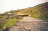
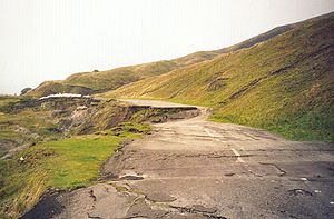
Dissolution of limestone
Subsidence frequently causes major problems in karstKARST
Kilometer-square Area Radio Synthesis Telescope is a Chinese telescope project to which FAST is a forerunner. KARST is a set of large spherical reflectors on karst landforms, which are bowlshaped limestone sinkholes named after the Kras region in Slovenia and Northern Italy. It will consist of...
terrains, where dissolution of limestone
Limestone
Limestone is a sedimentary rock composed largely of the minerals calcite and aragonite, which are different crystal forms of calcium carbonate . Many limestones are composed from skeletal fragments of marine organisms such as coral or foraminifera....
by fluid flow in the subsurface causes the creation of voids (i.e. cave
Cave
A cave or cavern is a natural underground space large enough for a human to enter. The term applies to natural cavities some part of which is in total darkness. The word cave also includes smaller spaces like rock shelters, sea caves, and grottos.Speleology is the science of exploration and study...
s). If the roof of these voids becomes too weak, it can collapse and the overlying rock and earth will fall into the space, causing subsidence at the surface. This type of subsidence can result in sinkhole
Sinkhole
A sinkhole, also known as a sink, shake hole, swallow hole, swallet, doline or cenote, is a natural depression or hole in the Earth's surface caused by karst processes — the chemical dissolution of carbonate rocks or suffosion processes for example in sandstone...
s which can be many hundreds of meters deep.
Mining
Several types of sub-surface miningSub-surface mining
Underground mining refers to a group of underground mining techniques used to extract coal, oil shale and other minerals or geological materials from sedimentary rocks...
, and specifically methods which intentionally cause the extracted void to collapse (such as pillar extraction, longwall mining
Longwall mining
Longwall mining is a form of underground coal mining where a long wall of coal is mined in a single slice . The longwall panel is typically 3–4 km long and 250–400 m wide....
and any metalliferous mining method which utilities "caving" such as "block caving" or "sub-level caving") will result in surface subsidence. Mining induced subsidence is relatively predictable in its magnitude, manifestation and extent, except where a sudden pillar or near-surface underground tunnel collapse occurs (usually very old workings). Mining-induced subsidence is nearly always very localized to the surface above the mined area, plus a margin around the outside. The vertical magnitude of the subsidence itself typically does not cause problems, except in the case of drainage (including natural drainage) - rather it is the associated surface compressive and tensile strains, curvature, tilts and horizontal displacement that are the cause of the worst damage to the natural environment, buildings and infrastructure.
Where mining activity is planned, mining-induced subsidence can be successfully managed if there is co-operation from all of the stakeholders. This is accomplished through a combination of careful mine planning, the taking of preventive measures, and the carrying out of repairs post-mining.
Extraction of natural gas
If natural gasNatural gas
Natural gas is a naturally occurring gas mixture consisting primarily of methane, typically with 0–20% higher hydrocarbons . It is found associated with other hydrocarbon fuel, in coal beds, as methane clathrates, and is an important fuel source and a major feedstock for fertilizers.Most natural...
is extracted from a natural gas field
Natural gas field
Oil and natural gas are produced by the same geological process according fossil fuel suggestion: anaerobic decay of organic matter deep under the Earth's surface. As a consequence, oil and natural gas are often found together...
the initial pressure (up to 60MPa (600 bar
Bar (unit)
The bar is a unit of pressure equal to 100 kilopascals, and roughly equal to the atmospheric pressure on Earth at sea level. Other units derived from the bar are the megabar , kilobar , decibar , centibar , and millibar...
)) in the field will drop over the years. The gas pressure also supports the soil layers above the field. If the pressure drops, the soil pressure increases and this leads to subsidence at the ground level. Major subsidence of the Mississippi River Delta
Mississippi River Delta
The Mississippi River Delta is the modern area of land built up by alluvium deposited by the Mississippi River as it slows down and enters the Gulf of Mexico...
due to oil and gas extraction has caused the ocean to rise and flood over 34 square miles (88.1 km²) of marshes and land each year. Since 1930, Louisiana
Louisiana
Louisiana is a state located in the southern region of the United States of America. Its capital is Baton Rouge and largest city is New Orleans. Louisiana is the only state in the U.S. with political subdivisions termed parishes, which are local governments equivalent to counties...
has lost 1200000 acres (4,856.2 km²).
Since exploration of the Slochteren
Slochteren
Slochteren is a municipality in the northeastern Netherlands.The municipality can be characterized as a chain of small villages dividing a mostly agricultural landscape. Having an agricultural background for at least a thousand years, the community houses for the most part commuters to nearby...
(Netherlands
Netherlands
The Netherlands is a constituent country of the Kingdom of the Netherlands, located mainly in North-West Europe and with several islands in the Caribbean. Mainland Netherlands borders the North Sea to the north and west, Belgium to the south, and Germany to the east, and shares maritime borders...
) gas field started in the late 1960s the ground level over a 250 km² area has dropped by a current maximum of 30 cm.
Earthquake
Geospatial Information Authority of JapanGeospatial Information Authority of Japan
The , or GSI, is the national institution responsible for surveying and mapping the national land of Japan. The former name of the organization, since 1949 to March 2010 was Geographical Survey Institute. It is an organization attached to the Ministry of Land, Infrastructure, Transport and Tourism...
reported immediate subsidence caused by 2011 Tōhoku earthquake
2011 Tōhoku earthquake and tsunami
The 2011 earthquake off the Pacific coast of Tohoku, also known as the 2011 Tohoku earthquake, or the Great East Japan Earthquake, was a magnitude 9.0 undersea megathrust earthquake off the coast of Japan that occurred at 14:46 JST on Friday, 11 March 2011, with the epicenter approximately east...
. Subsidence is observed on the coast of Pacific Ocean
Pacific Ocean
The Pacific Ocean is the largest of the Earth's oceanic divisions. It extends from the Arctic in the north to the Southern Ocean in the south, bounded by Asia and Australia in the west, and the Americas in the east.At 165.2 million square kilometres in area, this largest division of the World...
in Tōhoku region
Tohoku region
The is a geographical area of Japan. The region occupies the northeastern portion of Honshu, the largest island of Japan. The region consists of six prefectures : Akita, Aomori, Fukushima, Iwate, Miyagi and Yamagata....
, Miyako city
Miyako, Iwate
is a city located in Iwate, Japan.It was founded on February 11, 1941.The city lies along the coast where the flows into the Pacific Ocean. It is connected to Morioka by an east-west train line and highway and the coastal highway also goes through the town...
0.50 m (1.64 ft) in north, Rikuzentakata, Iwate
Rikuzentakata, Iwate
is a city in Iwate, Japan.In the quinquennial census of 2010, the city had a population of 23,302 . With a total area of 232.29 km² the density is 100 persons per km². The city was founded on January 1, 1955. The 2011 Tōhoku earthquake and tsunami caused extensive damage to the city.- Politics...
0.84 m (2.75 ft) to Sōma city
Soma, Fukushima
is a coastal city located in Fukushima, Japan, approximately 30 kilometers South of Sendai. Japan National Route 6 runs through Sōma, since 2001 augmented by the Route 6 Sōma Bypass, which runs up to 2 km East of the original route, around the city center....
0.29 m (0.95 ft) in south, the maximum amount is 1.2 m (3.93 ft) and also diastrophism
Diastrophism
Diastrophism refers to deformation of the Earth's crust, and more especially to folding and faulting. Diastrophism can be considered part of geotectonics. Diastrophism comes from the Greek word meaning a twisting....
5.3 m (17.3 ft) in horizontal
Horizontal plane
In geometry, physics, astronomy, geography, and related sciences, a plane is said to be horizontal at a given point if it is perpendicular to the gradient of the gravity field at that point— in other words, if apparent gravity makes a plumb bob hang perpendicular to the plane at that point.In...
toward ESE
Cardinal direction
The four cardinal directions or cardinal points are the directions of north, east, south, and west, commonly denoted by their initials: N, E, S, W. East and west are at right angles to north and south, with east being in the direction of rotation and west being directly opposite. Intermediate...
at Oshika Peninsula
Oshika Peninsula
The Oshika Peninsula is a peninsula which projects southeast into the Pacific Ocean from the coast of Miyagi Prefecture in northeast Honshu, the main island of Japan....
Miyagi
Miyagi Prefecture
is a prefecture of Japan in the Tōhoku Region on Honshu island. The capital is Sendai.- History :Miyagi Prefecture was formerly part of the province of Mutsu. Mutsu Province, on northern Honshu, was one of the last provinces to be formed as land was taken from the indigenous Emishi, and became the...
.
Groundwater-related subsidence
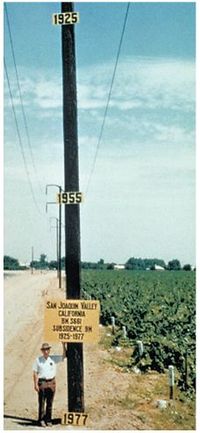
The habitation of lowland
Lowland
In physical geography, a lowland is any broad expanse of land with a general low level. The term is thus applied to the landward portion of the upward slope from oceanic depths to continental highlands, to a region of depression in the interior of a mountainous region, to a plain of denudation, or...
s, such as coast
Coast
A coastline or seashore is the area where land meets the sea or ocean. A precise line that can be called a coastline cannot be determined due to the dynamic nature of tides. The term "coastal zone" can be used instead, which is a spatial zone where interaction of the sea and land processes occurs...
al or delta
River delta
A delta is a landform that is formed at the mouth of a river where that river flows into an ocean, sea, estuary, lake, reservoir, flat arid area, or another river. Deltas are formed from the deposition of the sediment carried by the river as the flow leaves the mouth of the river...
plains, requires drainage
Drainage
Drainage is the natural or artificial removal of surface and sub-surface water from an area. Many agricultural soils need drainage to improve production or to manage water supplies.-Early history:...
. The resulting aeration of the soil
Soil
Soil is a natural body consisting of layers of mineral constituents of variable thicknesses, which differ from the parent materials in their morphological, physical, chemical, and mineralogical characteristics...
leads to the oxidation of its organic components, such as peat
Peat
Peat is an accumulation of partially decayed vegetation matter or histosol. Peat forms in wetland bogs, moors, muskegs, pocosins, mires, and peat swamp forests. Peat is harvested as an important source of fuel in certain parts of the world...
, and this decomposition process may cause significant land subsidence. This applies especially when ground water levels are periodically adapted to subsidence, in order to maintain desired unsaturated zone depths, exposing more and more peat to oxygen. In addition to this, drained soils consolidate as a result of increased effective stress
Effective stress
Karl von Terzaghi first proposed the relationship for effective stress in 1936. For him, the term ‘effective’ meant the calculated stress that was effective in moving soil, or causing displacements...
. In this way, land subsidence has the potential of becoming self-perpetuating, having rates up to 5 cm/yr. Water management
Water management
Water management is the activity of planning, developing, distributing and managing the optimum use of water resources. In an ideal world. water management planning has regard to all the competing demands for water and seeks to allocate water on an equitable basis to satisfy all uses and demands...
used to be tuned primarily to factors such as crop
Crop (agriculture)
A crop is a non-animal species or variety that is grown to be harvested as food, livestock fodder, fuel or for any other economic purpose. Major world crops include maize , wheat, rice, soybeans, hay, potatoes and cotton. While the term "crop" most commonly refers to plants, it can also include...
optimisation but, to varying extents, avoiding subsidence has come to be taken into account as well.
Faulting induced
When differential stresses exist in the Earth, these can be accommodated either by geological faulting in the brittle crustCrust (geology)
In geology, the crust is the outermost solid shell of a rocky planet or natural satellite, which is chemically distinct from the underlying mantle...
, or by ductile flow in the hotter and more fluid mantle
Mantle (geology)
The mantle is a part of a terrestrial planet or other rocky body large enough to have differentiation by density. The interior of the Earth, similar to the other terrestrial planets, is chemically divided into layers. The mantle is a highly viscous layer between the crust and the outer core....
. Where faults occur, absolute subsidence may occur in the hanging wall of normal faults. In reverse, or thrust, faults, relative subsidence may be measured in the footwall.
Isostatic subsidence
The crust floats buoyantly in the plastic asthenosphereAsthenosphere
The asthenosphere is the highly viscous, mechanically weak and ductilely-deforming region of the upper mantle of the Earth...
, with a ratio of mass below the "surface" in proportion to its own density and the density of the asthenosphere. If mass is added to a local area of the crust (e.g. through deposition), the crust subsides to compensate and maintain isostatic balance
Isostasy
Isostasy is a term used in geology to refer to the state of gravitational equilibrium between the earth's lithosphere and asthenosphere such that the tectonic plates "float" at an elevation which depends on their thickness and density. This concept is invoked to explain how different topographic...
. The opposite effect to Isostatic subsidence is known as isostatic rebound - the action of the crust returning (sometimes over periods of thousands of years) to a state of isostacy, such as after the melting of large Ice sheets or the drying-up of large lakes after the last ice age. Lake Bonneville is a famous example: Due to the weight of the water once held in the lake, the Earth's crust subsided nearly 200 feet (61 m) to maintain equilibrium, when the lake dried up, the crust rebounded. Today when you go to Lake Bonneville
Lake Bonneville
Lake Bonneville was a prehistoric pluvial lake that covered much of North America's Great Basin region. Most of the territory it covered was in present-day Utah, though parts of the lake extended into present-day Idaho and Nevada. Formed about 32,000 years ago, it existed until about 14,500 years...
you will find that the center of the former lake is about 200 feet (61 m) higher than the distant edges.