
Maui
Encyclopedia
The island
of Maui (icon; Hawaiian
: ˈmɐuwi)
is the second-largest of the Hawaiian Islands
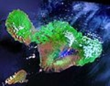
at 727.2 square miles (1,883.4 km²) and is the 17th largest island in the United States. Maui is part of the state of Hawaii
and is the largest of Maui County's
four islands, bigger than Lānai
, Kahoolawe
, and Molokai
. In 2010, Maui had a population of 144,444, third-highest of the Hawaiian islands, behind that of Oahu
and Hawaii
. Kahului is the largest census-designated place on the island with a population of 26,337 as of 2010. Wailuku
is the seat of Maui County. Other significant places include Kīhei, Lahaina, Makawao, Pāia
, Kula
, Haikū
, Hāna, Kāanapali, Wailea, Makena, and Kapalua.
, the Polynesia
n navigator credited with discovery of the Hawaiian Islands. According to that legend, Hawaiiloa named the island of Maui after his son, who in turn was named for the demigod Māui
. The earlier name of Maui was Ihikapalaumaewa. The Island of Maui is also called the "Valley Isle" for the large isthmus
between its northwestern and southeastern volcanoes and the numerous large valleys carved into both mountains.
is built of dark, iron
-rich/quartz
-poor rocks, which poured out of thousands of vents as highly fluid lava
, over a period of millions of years. Several of the volcanoes were close enough to each other that lava flows on their flanks overlapped one another, merging into a single island. Maui is such a "volcanic doublet", formed from two shield volcano
es that overlapped one another to form an isthmus
between them.
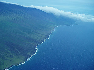
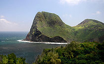
The older, western volcano has been eroded considerably and is cut by numerous drainages, forming the peaks of the West Maui Mountains (in Hawaiian Mauna Kahalawai). Puu Kukui is the highest of the peaks at 5788 feet (1,764.2 m). The larger, younger volcano to the east, Haleakalā
, rises to more than 10000 feet (3,048 m) above sea level, but measures 5 miles (8 km) from seafloor to summit, making it one of the world's highest "mountains".
 The eastern flanks of both volcanoes are cut by deeply incised valleys and steep-sided ravines that run downslope to the rocky, windswept shoreline. The valley-like Isthmus of Maui that separates the two volcanic masses was formed by sandy erosional deposits.
Maui's last eruption (originating in Haleakalā's Southwest Rift Zone) occurred around 1790; two of the resulting lava flows are located (1) at Cape Kīnau between Āhihi Bay and La Perouse Bay
on the southwest shore of East Maui, and (2) at Makaluapuna Point on Honokahua Bay on the northwest shore of West Maui. Although considered to be dormant by volcanologist
s, Haleakalā is certainly capable of further eruptions.
Maui is part of a much larger unit, Maui Nui
, that includes the islands of Lānai
, Kahoolawe
, Molokai
, and the now submerged Penguin Bank
. During periods of reduced sea level, including as recently as 20,000 years ago, they are joined together as a single island due to the shallowness of the channels between them.
 The climate of the Hawaiian Islands is characterized by a two-season year, mild and uniform temperatures everywhere (except at high elevations), marked geographic differences in rainfall, high relative humidity, extensive cloud formations (except on the driest coasts and at high elevations), and dominant trade-wind flow (especially at elevations below a few thousand feet). Maui itself has a wide range of climatic conditions and weather patterns that are influenced by several different factors in the physical environment:
Maui displays a unique and diverse set of climatic conditions, each of which is specific to a loosely defined sub-region of the island. These sub-regions are defined by major physiographic features (such as mountains and valleys) and by location on the windward or leeward side of the island. These sub-regions (and their characteristic climates) are:
Rainfall – Showers are very common; yet while some of these are very heavy, the vast majority are light and brief – a sudden sprinkle of rain and it's over. Even the heaviest rain showers are seldom accompanied by thunder and lightning. Throughout the lowlands, in summer an overwhelming dominance of trade wind
s produces a drier season. At one extreme, the annual rainfall averages 17 inches (431.8 mm) to 20 inches (508 mm) or less in leeward coastal areas, such as the shoreline from Maalaea Bay
to Kaupo, and near the summit of Haleakalā. At the other extreme, the annual average rainfall exceeds 300 inches (7,620 mm) along the lower windward slopes of Haleakalā, particularly along the Hāna Highway
. If the islands of the State of Hawaii did not exist, the average annual rainfall on the same patch of water would be about 25 inches (635 mm). Instead, the actual average is about 70 inches (1,778 mm). Thus, the islands extract from the air that passes over them about 45 inches (1,143 mm) of rainfall that otherwise would not fall. The mountainous topography of Maui and the other islands is responsible for this added water bonus.
 Daily Variations in Rainfall – In the lowlands, throughout the year, rainfall is most likely to occur during the night or morning hours, and is least likely to occur mid-afternoon. The most pronounced daily variations in rainfall occur during the summer because most summer rainfall consists of trade winds showers that most often occur at night. Winter rainfall in the lowlands is the result of storm activity, which is as likely to occur in the daytime as at night. Rainfall variability is far greater during the winter, when occasional storms contribute appreciably to rainfall totals. With such wide swings in rainfall, it is inevitable that there are occasional droughts, sometimes causing economic losses. The real drought years are the ones where the winter rains fail, with too few significant rainstorms. Droughts hit hardest in the normally dry areas that depend on winter storms for their rainfall and receive little rain from the trade wind showers.
s wintering in the sheltered Auau Channel
between the islands of Maui county. The whales migrate approximately 3500 miles (5,632.7 km) from Alaska
n waters each autumn and spend the winter months mating and birthing in the warm waters off Maui, with most leaving by the end of April. The whales are typically sighted in pods: small groups of several adults, or groups of a mother, her calf, and a few suitors. Humpbacks are an endangered species
protected by U.S. federal and Hawaii state law. There are estimated to be about 18,000 humpbacks in the North Pacific. Although Maui's Humpback face many dangers, due to pollution, high speed commercial vessels, and military sonar testing, their numbers have increased rapidly in recent years, estimated at 7% growth per year.
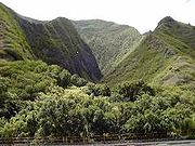
Maui is home to a large rainforest on the northeastern flanks of Haleakalā, which serves as the drainage basin
for the rest of the island. The extremely difficult terrain has prevented exploitation of much of the forest.
Agricultural and coastal industrial land use has had an adverse effect on much of Maui's coastal regions. Many of Maui's extraordinary coral reef
s have been damaged by pollution, runoff, and tourism, although finding sea turtles, dolphins, and Hawai'i's celebrated tropical fish, is still common. Leeward Maui used to boast a vibrant dry 'cloud forest' as well but this was destroyed by human activities over the last three hundred years.
 Polynesia
ns, from Tahiti
and the Marquesas, were the original peoples to populate Maui. The Tahitians introduced the kapu
system, a strict social order that affected all aspects of life and became the core of Hawaiian culture. Modern Hawaiian history began in the mid-18th century. King Kamehameha I, king of Hawaii's "Big Island," invaded Maui in 1790 and fought the inconclusive Battle of Kepaniwai
, but returned to Hawaii to battle a rival, finally subduing Maui a few years later.
On November 26, 1778, explorer Captain James Cook
became the first European to see Maui. Cook never set foot on the island because he was unable to find a suitable landing. The first European to visit Maui was the French
admiral Jean-François de La Pérouse
, who landed on the shores of what is now known as La Perouse Bay
on May 29, 1786. More Europeans followed: traders, whalers, loggers (e.g., of sandalwood
) and missionaries
. The latter began to arrive from New England
in 1823, settling in Lahaina, which at that time was the capital. They clothed the natives, banned them from dancing hula
, and greatly altered the culture. The missionaries taught reading and writing, created the 12-letter Hawaiian alphabet
, started a printing press in Lahaina, and began writing the islands' history, which until then was transmitted orally Ironically, the missionaries both altered and preserved the native culture. The religious work altered the culture while the literacy efforts preserved native history and language. Missionaries started the first school in Lahaina, which still exists today: Lahainaluna Mission School, which opened in 1831.
At the height of the whaling
era (1843–1860), Lahaina was a major whaling center with anchorage in Lāhainā Roads
; in one season over 400 ships visited Lahaina with 100 berthed at one time. Ships tended to stay for weeks rather than days, which explains the drinking and prostitution
in the town at that time, against which the missionaries vainly battled. Whaling declined steeply at the end of the 19th century as petroleum
replaced whale oil
.
Kamehameha's descendants reigned until 1872. They were followed by rulers from another ancient family of chiefs, including Queen Liliuokalani who ruled in 1893 when the monarchy was overthrown
. One year later, the Republic of Hawaii
was founded. The island was annexed
by the United States
in 1898 and made a territory in 1900. Hawaii became the 50th U.S. state
in 1959.
In 1937, Vibora Luviminda
trades union conducted the last labor strike of an ethnic nature in the Hawaiian Islands against four Maui sugarcane
plantations, demanding higher wages and the dismissal of five foremen. Manuel Fagel and nine other strike leaders were arrested, and charged with kidnapping a worker. Fagel spent four months in jail while the strike continued. Eventually, Vibora Luviminda made its point and the workers won a 15% increase in wages after 85 days on strike, but there was no written contract signed.
Maui was centrally involved in the Pacific Theater
of World War II
as a staging center, training base, and for rest and relaxation. At the peak in 1943-44, more than 100,000 soldiers were there. The main base of the 4th Marine Division was in Haiku
. Beaches (e.g., in Kīhei) were used to practice landings
and train in marine demolition and sabotage.
 The island experienced rapid population growth through 2007, when Kīhei was one of the most rapidly growing towns in the United States (see chart, below). The island attracted many retirees and many others came to provide services to them and to the rapidly increasing number of tourists. Population growth produced its usual strains, including traffic congestion, housing affordability, and access to water.
Most recent years have brought droughts and the Īao aquifer is being drawn from rates above 18 million U.S. gallons (68,000 m3) per day, possibly more than the aquifer can sustain. Recent estimates indicate that the total potential supply of potable water on Maui is around 476 million U.S. gallons (1,800,000 m3) per day, many times greater than any foreseeable demand.
Sugar cane cultivation
once used over 80% of the island's water supply (The Water Development Plan of Maui, 1992 – Present?). One pound of refined sugar requires one ton of water to produce. Water for sugar cultivation comes mostly from the streams of East Maui, routed though a network of tunnels and ditches hand dug by Chinese
labor in the 19th century. In 2006, the town of Paia
successfully petitioned the County against mixing in treated water from wells known to be contaminated with both EDB
and DBCP
from former pineapple cultivation in the area (Environment Hawaii, 1996). Agricultural companies have been released from all future liability for these chemicals (County of Maui, 1999). In 2009, the Office of Hawaiian Affairs and others successfully argued in court that sugar companies should reduce the amount of water they take from four streams.
In 1974 Emil Tedeschi of the winegrower family of Calistoga
, Napa Valley established the first and only Hawaiian commercial winery, the Tedeschi Winery at Ulupalakua Ranch.
In the first decade of the 21st century, controversies over whether to continue rapid real-estate development, so-called "vacation rentals" in which homeowners rent their homes to visitors, and the Super Ferry preoccupied local residents. In 2009, the county approved a 1,000 unit development in South Maui in the teeth of the financial crisis. Vacation rentals are now strictly limited, with greater enforcement than previously. The Super Ferry, which offered transport between Maui and Oahu is now defunct, killed by a court decision that required environmental studies from which Governor Linda Lingle had exempted the operator.
 The two major industries on Maui are agriculture
and tourism
. However, government research groups and high technology companies have discovered that Maui has a business environment favorable for growth in those sectors. Agriculture value-added enterprises are growing rapidly.
Coffee
, macadamia nuts, papaya
, tropical flower
s, sugar
and fresh pineapple
are just some of Hawaii's premium exports and are a great example of its diversified agriculture. Maui Land & Pineapple Company
and Hawaiian Commercial and Sugar Company (HC&S, a subsidiary of Alexander and Baldwin Company) dominate agricultural activity. HC&S produces sugarcane on about 37000 acres (149.7 km²) of the Maui central valley, the largest sugarcane operation remaining in Hawaii.
A controversial feature of Maui sugarcane production is the harvesting method of controlled cane field fires for nine months of the year. Burns reduce the crop to bare canes just before harvesting. The fires produce smoke that towers above the Maui central valley most early mornings, and ash (locally referred to as "Maui snow") that is carried downwind (often towards north Kīhei). In November 2009 Maui Land & Pineapple Company announced it was ceasing pineapple growing operations on Maui effective January 1, 2010.
The Maui High Performance Computing Center
(MHPCC) in Kihei is a U.S. Air Force Research Laboratory Center which is managed by the University of Hawaii
. It provides more than 10,000,000 hours of computing time per year to the research, science, and military communities.
Another promoter of high technology on Maui is the Maui Research and Technology Center, also located in Kihei. The MRTC is a program of the High Technology Development Corporation (HTDC), an agency of the State of Hawaii, whose focus is to facilitate the growth of Hawaii's commercial high technology sector.
Maui is also an important center for advanced astronomical research. The Haleakala Observatory
was Hawaii's first astronomical research and development facility at the Maui Space Surveillance Site (MSSS) electro-optical facility. "At the 10,023 feet summit of the long dormant volcano Haleakala, operational satellite tracking facilities are co-located with a research and development facility providing superb data acquisition and communication support. The high elevation, dry climate, and freedom from light pollution offer virtually year-round observation of satellites, missiles, man-made orbital debris, and astronomical objects."
The unemployment rate reached a low of 1.7% in December, 2006, rising to 9% in March 2009.
team has teams in Rugby sevens
, rugby league
and rugby union
.
, Haleakalā National Park
, and Lahaina.
The Hāna Highway runs along the east coast of Maui, curving around many mountains and passing by black sand
beaches and waterfall
s. Haleakalā National Park is home to Haleakalā
, a dormant volcano
. Lahaina is one of the main attractions on the island with an entire street of shops and restaurants which lead to a wharf where many set out for a sunset cruise or whale watching journey. Snorkeling can be done at almost any beach along the Maui coast. Surfing and windsurfing are also popular on Maui.
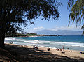
The main tourist areas are West Maui (Kāanapali
, Lahaina, Nāpili-Honokōwai
, Kahana
, Napili
, Kapalua
), and South Maui (Kīhei
, Wailea-Mākena
). The main port of call for cruise ships is located in Kahului. A smaller port can be found in Maalaea Harbor located between Lahaina and Kihei.
Maui County welcomed 2,207,826 tourists in 2004 rising to 2,639,929 in 2007 with total tourist expenditures north of US$3.5 billion for the Island of Maui alone. While the island of Oahu
is most popular with Japan
ese tourists, the Island of Maui appeals to visitors mostly from the U.S. mainland and Canada
: in 2005, there were 2,003,492 domestic arrivals on the island, compared to 260,184 international arrivals.
While winning many travel industry awards as Best Island In The World in recent years concerns have been raised by locals and environmentalists about the overdevelopment of Maui. A number of activist groups, including Save Makena have gone as far as taking the government to court to protect the rights of local citizens.
Throughout 2008 Maui suffered a major loss in tourism compounded by the spring bankruptcies of Aloha Airlines
and ATA Airlines
. The pullout in May of the second of three Norwegian Cruise Line
ships also hurt. Pacific Business News reported a $166 million loss in revenue for Maui tourism businesses.
The Maui Public Bus Transit System is a county-funded program that provides transportation around the island with fares costing $1 per boarding.
Island
An island or isle is any piece of sub-continental land that is surrounded by water. Very small islands such as emergent land features on atolls can be called islets, cays or keys. An island in a river or lake may be called an eyot , or holm...
of Maui (icon; Hawaiian
Hawaiian language
The Hawaiian language is a Polynesian language that takes its name from Hawaii, the largest island in the tropical North Pacific archipelago where it developed. Hawaiian, along with English, is an official language of the state of Hawaii...
: ˈmɐuwi)
is the second-largest of the Hawaiian Islands
Hawaiian Islands
The Hawaiian Islands are an archipelago of eight major islands, several atolls, numerous smaller islets, and undersea seamounts in the North Pacific Ocean, extending some 1,500 miles from the island of Hawaii in the south to northernmost Kure Atoll...
at 727.2 square miles (1,883.4 km²) and is the 17th largest island in the United States. Maui is part of the state of Hawaii
Hawaii
Hawaii is the newest of the 50 U.S. states , and is the only U.S. state made up entirely of islands. It is the northernmost island group in Polynesia, occupying most of an archipelago in the central Pacific Ocean, southwest of the continental United States, southeast of Japan, and northeast of...
and is the largest of Maui County's
Maui County, Hawaii
-National protected areas:* Haleakala National Park* Kakahaia National Wildlife Refuge* Kealia Pond National Wildlife Refuge- Demographics :As of the 2000 Census, there were 128,094 people, 43,507 households, and 29,889 families residing in the county. The population density was 110 people per...
four islands, bigger than Lānai
Lanai
Lānai or Lanai is the sixth-largest of the Hawaiian Islands. It is also known as the Pineapple Island because of its past as an island-wide pineapple plantation. The only town is Lānai City, a small settlement....
, Kahoolawe
Kahoolawe
Kahoolawe is the smallest of the eight main volcanic islands in the Hawaiian Islands. Kahoolawe is located about seven miles southwest of Maui and also southeast of Lanai, and it is long by wide, with a total land area of . The highest point on Kahoolawe is the crater of Lua Makika at the...
, and Molokai
Molokai
Molokai or Molokai is an island in the Hawaiian archipelago. It is 38 by 10 miles in size with a land area of , making it the fifth largest of the main Hawaiian Islands and the 27th largest island in the United States. It lies east of Oahu across the 25-mile wide Kaiwi Channel and north of...
. In 2010, Maui had a population of 144,444, third-highest of the Hawaiian islands, behind that of Oahu
Oahu
Oahu or Oahu , known as "The Gathering Place", is the third largest of the Hawaiian Islands and most populous of the islands in the U.S. state of Hawaii. The state capital Honolulu is located on the southeast coast...
and Hawaii
Hawaii (island)
The Island of Hawaii, also called the Big Island or Hawaii Island , is a volcanic island in the North Pacific Ocean...
. Kahului is the largest census-designated place on the island with a population of 26,337 as of 2010. Wailuku
Wailuku, Hawaii
Wailuku is a census-designated place in Maui County, Hawaii, United States. The population was 12,296 at the 2000 census. It is the county seat of Maui County.Wailuku is located just west of Kahului, at the mouth of the Īao Valley...
is the seat of Maui County. Other significant places include Kīhei, Lahaina, Makawao, Pāia
Paia, Hawaii
Pāia is a census-designated place in Maui County, Hawaii, on the northern coast of the island of Maui. The population was 2,499 at the 2000 census. Pāia is home to several restaurants, art galleries, surf shops and other tourist-oriented businesses. One business, Charley's, is frequented by...
, Kula
Kula, Hawaii
Kula is a district of Maui, Hawaii that stretches across the "up-country", the western-facing slopes of Haleakalā, from Makawao to Ulupalakua. Most of the residential areas lie between about 500 to 1,100 m in elevation...
, Haikū
Haiku, Hawaii
Haiku is an unincorporated community in Maui County on the island of Maui in the state of Hawaii. For United States Census purposes, it is part of the Haiku-Pauwela, Hawaii census-designated place, which also includes Pauwela....
, Hāna, Kāanapali, Wailea, Makena, and Kapalua.
Name
Native Hawaiian tradition gives the origin of the island's name in the legend of HawaiiloaHawaiiloa
Hawaiiloa is the hero of an ancient Hawaiian legend about the settling of the Hawaiian Islands. After having accidentally stumbled upon the islands, he returned to his homeland which he called Ka āina kai melemele a Kane, "the land of the yellow sea of Kane". He then organized a colonizing...
, the Polynesia
Polynesia
Polynesia is a subregion of Oceania, made up of over 1,000 islands scattered over the central and southern Pacific Ocean. The indigenous people who inhabit the islands of Polynesia are termed Polynesians and they share many similar traits including language, culture and beliefs...
n navigator credited with discovery of the Hawaiian Islands. According to that legend, Hawaiiloa named the island of Maui after his son, who in turn was named for the demigod Māui
Maui (Hawaiian mythology)
In Hawaiian mythology, Māui is a culture hero who appears in several different genealogies. In the Ulu line he is the son of Akalana and his wife Hinakawea . This couple has four sons, Māui-mua, Māui-hope, Māui-kiikii and Māui-a-kalana. Māui-a-kalana's wife is named Hinakealohaila; and his son is...
. The earlier name of Maui was Ihikapalaumaewa. The Island of Maui is also called the "Valley Isle" for the large isthmus
Isthmus
An isthmus is a narrow strip of land connecting two larger land areas usually with waterforms on either side.Canals are often built through isthmuses where they may be particularly advantageous to create a shortcut for marine transportation...
between its northwestern and southeastern volcanoes and the numerous large valleys carved into both mountains.
Geology and topography
Maui's diverse landscapes are the result of a unique combination of geology, topography, and climate. Each volcanic cone in the chain of the Hawaiian IslandsHawaiian Islands
The Hawaiian Islands are an archipelago of eight major islands, several atolls, numerous smaller islets, and undersea seamounts in the North Pacific Ocean, extending some 1,500 miles from the island of Hawaii in the south to northernmost Kure Atoll...
is built of dark, iron
Iron
Iron is a chemical element with the symbol Fe and atomic number 26. It is a metal in the first transition series. It is the most common element forming the planet Earth as a whole, forming much of Earth's outer and inner core. It is the fourth most common element in the Earth's crust...
-rich/quartz
Quartz
Quartz is the second-most-abundant mineral in the Earth's continental crust, after feldspar. It is made up of a continuous framework of SiO4 silicon–oxygen tetrahedra, with each oxygen being shared between two tetrahedra, giving an overall formula SiO2. There are many different varieties of quartz,...
-poor rocks, which poured out of thousands of vents as highly fluid lava
Lava
Lava refers both to molten rock expelled by a volcano during an eruption and the resulting rock after solidification and cooling. This molten rock is formed in the interior of some planets, including Earth, and some of their satellites. When first erupted from a volcanic vent, lava is a liquid at...
, over a period of millions of years. Several of the volcanoes were close enough to each other that lava flows on their flanks overlapped one another, merging into a single island. Maui is such a "volcanic doublet", formed from two shield volcano
Shield volcano
A shield volcano is a type of volcano usually built almost entirely of fluid lava flows. They are named for their large size and low profile, resembling a warrior's shield. This is caused by the highly fluid lava they erupt, which travels farther than lava erupted from more explosive volcanoes...
es that overlapped one another to form an isthmus
Isthmus
An isthmus is a narrow strip of land connecting two larger land areas usually with waterforms on either side.Canals are often built through isthmuses where they may be particularly advantageous to create a shortcut for marine transportation...
between them.
The older, western volcano has been eroded considerably and is cut by numerous drainages, forming the peaks of the West Maui Mountains (in Hawaiian Mauna Kahalawai). Puu Kukui is the highest of the peaks at 5788 feet (1,764.2 m). The larger, younger volcano to the east, Haleakalā
Haleakala
Haleakalā , or the East Maui Volcano, is a massive shield volcano that forms more than 75% of the Hawaiian Island of Maui. The western 25% of the island is formed by the West Maui Mountains.- History :...
, rises to more than 10000 feet (3,048 m) above sea level, but measures 5 miles (8 km) from seafloor to summit, making it one of the world's highest "mountains".
Maui's last eruption (originating in Haleakalā's Southwest Rift Zone) occurred around 1790; two of the resulting lava flows are located (1) at Cape Kīnau between Āhihi Bay and La Perouse Bay
La Perouse Bay
La Perouse Bay is located south of the town of Wailea-Makena, Hawaii at the end of Makena Alanui Road at . The bay's Hawaiian name is Keoneoio....
on the southwest shore of East Maui, and (2) at Makaluapuna Point on Honokahua Bay on the northwest shore of West Maui. Although considered to be dormant by volcanologist
Volcanologist
A volcanologist is a person who studies the formation of volcanoes, and their current and historic eruptions. Volcanologists frequently visit volcanoes, especially active ones, to observe volcanic eruptions, collect eruptive products including tephra , rock and lava samples...
s, Haleakalā is certainly capable of further eruptions.
Maui is part of a much larger unit, Maui Nui
Maui Nui
Maui Nui or Greater Maui, is a modern geologists' name given to a prehistoric Hawaiian Island built from seven shield volcanoes. Nui means "great/large" in the Hawaiian language....
, that includes the islands of Lānai
Lanai
Lānai or Lanai is the sixth-largest of the Hawaiian Islands. It is also known as the Pineapple Island because of its past as an island-wide pineapple plantation. The only town is Lānai City, a small settlement....
, Kahoolawe
Kahoolawe
Kahoolawe is the smallest of the eight main volcanic islands in the Hawaiian Islands. Kahoolawe is located about seven miles southwest of Maui and also southeast of Lanai, and it is long by wide, with a total land area of . The highest point on Kahoolawe is the crater of Lua Makika at the...
, Molokai
Molokai
Molokai or Molokai is an island in the Hawaiian archipelago. It is 38 by 10 miles in size with a land area of , making it the fifth largest of the main Hawaiian Islands and the 27th largest island in the United States. It lies east of Oahu across the 25-mile wide Kaiwi Channel and north of...
, and the now submerged Penguin Bank
Penguin Bank
Penguin Bank is the name given to a now-submerged shield volcano of the Hawaiian Islands. Its coral-capped remains lay west of the island of Molokai under relatively shallow water...
. During periods of reduced sea level, including as recently as 20,000 years ago, they are joined together as a single island due to the shallowness of the channels between them.
Climate
- Half of Maui is situated within 5 miles (8 km) of the island's coastline. This, and the extreme insularity of the Hawaiian Islands themselves account for the strong marine influence on Maui's climate.
- Gross weather patterns are typically determined by elevation and orientation towards the Trade winds (prevailing air flow comes from the northeast).
- Maui's rugged, irregular topography produces marked variations in conditions. Air swept inland on the Trade winds is shunted one way or another by the mountains, valleys, and vast open slopes. This complex three-dimensional flow of air results in striking variations in wind speed, cloud formation, and rainfall.
Maui displays a unique and diverse set of climatic conditions, each of which is specific to a loosely defined sub-region of the island. These sub-regions are defined by major physiographic features (such as mountains and valleys) and by location on the windward or leeward side of the island. These sub-regions (and their characteristic climates) are:
- Windward Lowlands – Below 2000 feet (609.6 m) on north- to northeast-sides of an island. Roughly perpendicular to direction of prevailing trade winds. Moderately rainy; frequent trade wind-induced showers. Skies are often cloudy to partly cloudy. Air temperatures are more uniform (and mild) than those of other regions.
- Leeward Lowlands – Daytime temperatures are a little higher and nighttime temperatures are lower than in windward locations. Dry weather is prevalent, with the exception of sporadic showers that drift over the mountains to windward and during short-duration storms.
- Interior Lowlands – Intermediate conditions, often sharing characteristics of other lowland sub-regions. Occasionally experience intense local afternoon showers from well-developed clouds that formed due to local daytime heating.
- Leeward Side High-Altitude Mountain Slopes with High Rainfall – Extensive cloud cover and rainfall all year long. Mild temperatures are prevalent, but humidity is higher than any other sub-region.
- Leeward Side-Lower Mountain Slopes – Rainfall is higher than on the adjacent leeward lowlands, but much less than at similar altitudes on the windward side; however, maximum rainfall usually occurs leeward of the crests of lower mountains. Temperatures are higher than on the rainy slopes of the windward sides of mountains; cloud cover is almost as extensive.
- High Mountains – Above about 3000 feet (914.4 m) on Haleakalā, rainfall decreases rapidly with elevation. Relative humidity may be ten percent or less. The lowest temperatures in the state are experienced in this region: air temperatures below freezing are common.
Rainfall – Showers are very common; yet while some of these are very heavy, the vast majority are light and brief – a sudden sprinkle of rain and it's over. Even the heaviest rain showers are seldom accompanied by thunder and lightning. Throughout the lowlands, in summer an overwhelming dominance of trade wind
Trade wind
The trade winds are the prevailing pattern of easterly surface winds found in the tropics, within the lower portion of the Earth's atmosphere, in the lower section of the troposphere near the Earth's equator...
s produces a drier season. At one extreme, the annual rainfall averages 17 inches (431.8 mm) to 20 inches (508 mm) or less in leeward coastal areas, such as the shoreline from Maalaea Bay
Ma'alaea Bay
Ma'alaea Bay is a large bay in the southwestern coast of Maui, in the Hawaiian islands. Several small towns are located close to the bay, notably the town which shares its name, Maalaea....
to Kaupo, and near the summit of Haleakalā. At the other extreme, the annual average rainfall exceeds 300 inches (7,620 mm) along the lower windward slopes of Haleakalā, particularly along the Hāna Highway
Hana Highway
The Hāna Highway is a long stretch of Hawaii State Routes 36 and 360 which connects Kahului with the town of Hāna in east Maui. On the east after Kalepa bridge, Hana Highway continues to Kīpahulu as Route 31 , the first section of which is unofficially considered to be part of Hāna Highway...
. If the islands of the State of Hawaii did not exist, the average annual rainfall on the same patch of water would be about 25 inches (635 mm). Instead, the actual average is about 70 inches (1,778 mm). Thus, the islands extract from the air that passes over them about 45 inches (1,143 mm) of rainfall that otherwise would not fall. The mountainous topography of Maui and the other islands is responsible for this added water bonus.
Natural history
Maui is a leading whale-watching center in the Hawaiian Islands due to Humpback whaleHumpback Whale
The humpback whale is a species of baleen whale. One of the larger rorqual species, adults range in length from and weigh approximately . The humpback has a distinctive body shape, with unusually long pectoral fins and a knobbly head. It is an acrobatic animal, often breaching and slapping the...
s wintering in the sheltered Auau Channel
Hawaiian islands channels
In an archipelago like the Hawaiian Islands the water between islands is typically called a channel or passage. Described here are the channels between the islands of Hawaii, arranged from southeast to northwest.- Alenuihāhā Channel :...
between the islands of Maui county. The whales migrate approximately 3500 miles (5,632.7 km) from Alaska
Alaska
Alaska is the largest state in the United States by area. It is situated in the northwest extremity of the North American continent, with Canada to the east, the Arctic Ocean to the north, and the Pacific Ocean to the west and south, with Russia further west across the Bering Strait...
n waters each autumn and spend the winter months mating and birthing in the warm waters off Maui, with most leaving by the end of April. The whales are typically sighted in pods: small groups of several adults, or groups of a mother, her calf, and a few suitors. Humpbacks are an endangered species
Endangered species
An endangered species is a population of organisms which is at risk of becoming extinct because it is either few in numbers, or threatened by changing environmental or predation parameters...
protected by U.S. federal and Hawaii state law. There are estimated to be about 18,000 humpbacks in the North Pacific. Although Maui's Humpback face many dangers, due to pollution, high speed commercial vessels, and military sonar testing, their numbers have increased rapidly in recent years, estimated at 7% growth per year.
Maui is home to a large rainforest on the northeastern flanks of Haleakalā, which serves as the drainage basin
Drainage basin
A drainage basin is an extent or an area of land where surface water from rain and melting snow or ice converges to a single point, usually the exit of the basin, where the waters join another waterbody, such as a river, lake, reservoir, estuary, wetland, sea, or ocean...
for the rest of the island. The extremely difficult terrain has prevented exploitation of much of the forest.
Agricultural and coastal industrial land use has had an adverse effect on much of Maui's coastal regions. Many of Maui's extraordinary coral reef
Coral reef
Coral reefs are underwater structures made from calcium carbonate secreted by corals. Coral reefs are colonies of tiny living animals found in marine waters that contain few nutrients. Most coral reefs are built from stony corals, which in turn consist of polyps that cluster in groups. The polyps...
s have been damaged by pollution, runoff, and tourism, although finding sea turtles, dolphins, and Hawai'i's celebrated tropical fish, is still common. Leeward Maui used to boast a vibrant dry 'cloud forest' as well but this was destroyed by human activities over the last three hundred years.
History
Polynesia
Polynesia is a subregion of Oceania, made up of over 1,000 islands scattered over the central and southern Pacific Ocean. The indigenous people who inhabit the islands of Polynesia are termed Polynesians and they share many similar traits including language, culture and beliefs...
ns, from Tahiti
Tahiti
Tahiti is the largest island in the Windward group of French Polynesia, located in the archipelago of the Society Islands in the southern Pacific Ocean. It is the economic, cultural and political centre of French Polynesia. The island was formed from volcanic activity and is high and mountainous...
and the Marquesas, were the original peoples to populate Maui. The Tahitians introduced the kapu
Kapu
Kapu refers to the ancient Hawaiian code of conduct of laws and regulations. The kapu system was universal in lifestyle, gender roles, politics, religion, etc. An offense that was kapu was often a corporal offense, but also often denoted a threat to spiritual power, or theft of mana. Kapus were...
system, a strict social order that affected all aspects of life and became the core of Hawaiian culture. Modern Hawaiian history began in the mid-18th century. King Kamehameha I, king of Hawaii's "Big Island," invaded Maui in 1790 and fought the inconclusive Battle of Kepaniwai
Battle of Kepaniwai
The Battle of Kepaniwai was fought in 1790 between Hawaii Island and Maui. The forces of Hawaii were led by Kamehameha I, while the forces of Maui were led by Kalanikūpule...
, but returned to Hawaii to battle a rival, finally subduing Maui a few years later.
On November 26, 1778, explorer Captain James Cook
James Cook
Captain James Cook, FRS, RN was a British explorer, navigator and cartographer who ultimately rose to the rank of captain in the Royal Navy...
became the first European to see Maui. Cook never set foot on the island because he was unable to find a suitable landing. The first European to visit Maui was the French
France
The French Republic , The French Republic , The French Republic , (commonly known as France , is a unitary semi-presidential republic in Western Europe with several overseas territories and islands located on other continents and in the Indian, Pacific, and Atlantic oceans. Metropolitan France...
admiral Jean-François de La Pérouse
Jean-François de Galaup, comte de La Pérouse
Jean François de Galaup, comte de Lapérouse was a French Navy officer and explorer whose expedition vanished in Oceania.-Early career:...
, who landed on the shores of what is now known as La Perouse Bay
La Perouse Bay
La Perouse Bay is located south of the town of Wailea-Makena, Hawaii at the end of Makena Alanui Road at . The bay's Hawaiian name is Keoneoio....
on May 29, 1786. More Europeans followed: traders, whalers, loggers (e.g., of sandalwood
Sandalwood
Sandalwood is the name of a class of fragrant woods from trees in the genus Santalum. The woods are heavy, yellow, and fine-grained, and unlike many other aromatic woods they retain their fragrance for decades. As well as using the harvested and cut wood in-situ, essential oils are also extracted...
) and missionaries
Missionary
A missionary is a member of a religious group sent into an area to do evangelism or ministries of service, such as education, literacy, social justice, health care and economic development. The word "mission" originates from 1598 when the Jesuits sent members abroad, derived from the Latin...
. The latter began to arrive from New England
New England
New England is a region in the northeastern corner of the United States consisting of the six states of Maine, New Hampshire, Vermont, Massachusetts, Rhode Island, and Connecticut...
in 1823, settling in Lahaina, which at that time was the capital. They clothed the natives, banned them from dancing hula
Hula
Hula is a dance form accompanied by chant or song . It was developed in the Hawaiian Islands by the Polynesians who originally settled there. The hula dramatizes or portrays the words of the oli or mele in a visual dance form....
, and greatly altered the culture. The missionaries taught reading and writing, created the 12-letter Hawaiian alphabet
Hawaiian alphabet
The Hawaiian alphabet, ka pīʻāpā Hawaiʻi, was adapted from the English alphabet in the early 19th century by American missionaries to print a Hawaiian bible.- Origins :...
, started a printing press in Lahaina, and began writing the islands' history, which until then was transmitted orally Ironically, the missionaries both altered and preserved the native culture. The religious work altered the culture while the literacy efforts preserved native history and language. Missionaries started the first school in Lahaina, which still exists today: Lahainaluna Mission School, which opened in 1831.
At the height of the whaling
Whaling
Whaling is the hunting of whales mainly for meat and oil. Its earliest forms date to at least 3000 BC. Various coastal communities have long histories of sustenance whaling and harvesting beached whales...
era (1843–1860), Lahaina was a major whaling center with anchorage in Lāhainā Roads
Hawaiian islands channels
In an archipelago like the Hawaiian Islands the water between islands is typically called a channel or passage. Described here are the channels between the islands of Hawaii, arranged from southeast to northwest.- Alenuihāhā Channel :...
; in one season over 400 ships visited Lahaina with 100 berthed at one time. Ships tended to stay for weeks rather than days, which explains the drinking and prostitution
Prostitution
Prostitution is the act or practice of providing sexual services to another person in return for payment. The person who receives payment for sexual services is called a prostitute and the person who receives such services is known by a multitude of terms, including a "john". Prostitution is one of...
in the town at that time, against which the missionaries vainly battled. Whaling declined steeply at the end of the 19th century as petroleum
Petroleum
Petroleum or crude oil is a naturally occurring, flammable liquid consisting of a complex mixture of hydrocarbons of various molecular weights and other liquid organic compounds, that are found in geologic formations beneath the Earth's surface. Petroleum is recovered mostly through oil drilling...
replaced whale oil
Whale oil
Whale oil is the oil obtained from the blubber of various species of whales, particularly the three species of right whale and the bowhead whale prior to the modern era, as well as several other species of baleen whale...
.
Kamehameha's descendants reigned until 1872. They were followed by rulers from another ancient family of chiefs, including Queen Liliuokalani who ruled in 1893 when the monarchy was overthrown
Overthrow of the Hawaiian Monarchy
Until the 1890s the Kingdom of Hawaii was an independent sovereign state, recognized by the United States, the United Kingdom, France, Japan, and Germany. Though there were threats to Hawaii's sovereignty throughout the Kingdom's history, it was not until the signing, under duress, of the Bayonet...
. One year later, the Republic of Hawaii
Republic of Hawaii
The Republic of Hawaii was the formal name of the government that controlled Hawaii from 1894 to 1898 when it was run as a republic. The republic period occurred between the administration of the Provisional Government of Hawaii which ended on July 4, 1894 and the adoption of the Newlands...
was founded. The island was annexed
Annexation
Annexation is the de jure incorporation of some territory into another geo-political entity . Usually, it is implied that the territory and population being annexed is the smaller, more peripheral, and weaker of the two merging entities, barring physical size...
by the United States
United States
The United States of America is a federal constitutional republic comprising fifty states and a federal district...
in 1898 and made a territory in 1900. Hawaii became the 50th U.S. state
U.S. state
A U.S. state is any one of the 50 federated states of the United States of America that share sovereignty with the federal government. Because of this shared sovereignty, an American is a citizen both of the federal entity and of his or her state of domicile. Four states use the official title of...
in 1959.
In 1937, Vibora Luviminda
Vibora Luviminda
The Vibora Luviminda, a secretive organization focused largely on Filipino labor issues, was founded in 1924 on the island of Maui by Manuel Fagel....
trades union conducted the last labor strike of an ethnic nature in the Hawaiian Islands against four Maui sugarcane
Sugarcane
Sugarcane refers to any of six to 37 species of tall perennial grasses of the genus Saccharum . Native to the warm temperate to tropical regions of South Asia, they have stout, jointed, fibrous stalks that are rich in sugar, and measure two to six metres tall...
plantations, demanding higher wages and the dismissal of five foremen. Manuel Fagel and nine other strike leaders were arrested, and charged with kidnapping a worker. Fagel spent four months in jail while the strike continued. Eventually, Vibora Luviminda made its point and the workers won a 15% increase in wages after 85 days on strike, but there was no written contract signed.
Maui was centrally involved in the Pacific Theater
Pacific Theater of Operations
The Pacific Theater of Operations was the World War II area of military activity in the Pacific Ocean and the countries bordering it, a geographic scope that reflected the operational and administrative command structures of the American forces during that period...
of World War II
World War II
World War II, or the Second World War , was a global conflict lasting from 1939 to 1945, involving most of the world's nations—including all of the great powers—eventually forming two opposing military alliances: the Allies and the Axis...
as a staging center, training base, and for rest and relaxation. At the peak in 1943-44, more than 100,000 soldiers were there. The main base of the 4th Marine Division was in Haiku
Haiku, Hawaii
Haiku is an unincorporated community in Maui County on the island of Maui in the state of Hawaii. For United States Census purposes, it is part of the Haiku-Pauwela, Hawaii census-designated place, which also includes Pauwela....
. Beaches (e.g., in Kīhei) were used to practice landings
Amphibious warfare
Amphibious warfare is the use of naval firepower, logistics and strategy to project military power ashore. In previous eras it stood as the primary method of delivering troops to non-contiguous enemy-held terrain...
and train in marine demolition and sabotage.
Modern development
Most recent years have brought droughts and the Īao aquifer is being drawn from rates above 18 million U.S. gallons (68,000 m3) per day, possibly more than the aquifer can sustain. Recent estimates indicate that the total potential supply of potable water on Maui is around 476 million U.S. gallons (1,800,000 m3) per day, many times greater than any foreseeable demand.
Sugar cane cultivation
Sugar plantations in Hawaii
Sugarcane was introduced to Hawaii by its first inhabitants in approximately 600 AD and was observed by Captain Cook upon arrival in the islands in 1778. Sugar quickly turned into a big business and generated rapid population growth in the islands with 337,000 people immigrating over the span of a...
once used over 80% of the island's water supply (The Water Development Plan of Maui, 1992 – Present?). One pound of refined sugar requires one ton of water to produce. Water for sugar cultivation comes mostly from the streams of East Maui, routed though a network of tunnels and ditches hand dug by Chinese
Chinese immigration to Hawaii
The Chinese in Hawaii frequently referred to by their Hawaiian name Pākē, constitute about 4.7% of the state's population, most of whom have ancestors from Zhongshan in Guangdong. This number does not include people of mixed Chinese and Hawaiian descent...
labor in the 19th century. In 2006, the town of Paia
Paia, Hawaii
Pāia is a census-designated place in Maui County, Hawaii, on the northern coast of the island of Maui. The population was 2,499 at the 2000 census. Pāia is home to several restaurants, art galleries, surf shops and other tourist-oriented businesses. One business, Charley's, is frequented by...
successfully petitioned the County against mixing in treated water from wells known to be contaminated with both EDB
EDB
-Science and medicine:* Ethylene dibromide, a chemical substance also known as 1,2-Dibromoethane.* Extensor digitorum brevis, a muscle in the foot.-Computer Software:* Evan's Debugger , a Qt4-based debugger for Linux, modeled after OllyDbg...
and DBCP
DBCP
1,2-Dibromo-3-chloropropane, better known as DBCP, is the active ingredient in the nematicide Nemagon, also known as Fumazone. It is a soil fumigant formerly used in American agriculture. In mammals it causes male sterility at high levels of exposure...
from former pineapple cultivation in the area (Environment Hawaii, 1996). Agricultural companies have been released from all future liability for these chemicals (County of Maui, 1999). In 2009, the Office of Hawaiian Affairs and others successfully argued in court that sugar companies should reduce the amount of water they take from four streams.
In 1974 Emil Tedeschi of the winegrower family of Calistoga
Calistoga, California
Calistoga is a city in Napa County, California, United States. The population was 5,155 at the 2010 census.-Geography:According to the United States Census Bureau, the city has a total area of , 99.30% of it land and 0.70% of it water.-Climate:...
, Napa Valley established the first and only Hawaiian commercial winery, the Tedeschi Winery at Ulupalakua Ranch.
In the first decade of the 21st century, controversies over whether to continue rapid real-estate development, so-called "vacation rentals" in which homeowners rent their homes to visitors, and the Super Ferry preoccupied local residents. In 2009, the county approved a 1,000 unit development in South Maui in the teeth of the financial crisis. Vacation rentals are now strictly limited, with greater enforcement than previously. The Super Ferry, which offered transport between Maui and Oahu is now defunct, killed by a court decision that required environmental studies from which Governor Linda Lingle had exempted the operator.
Economy
Agriculture in the United States
Agriculture is a major industry in the United States and the country is a net exporter of food. As of the last census of agriculture in 2007, there were 2.2 million farms, covering an area of , an average of per farm.-History:...
and tourism
Tourism in the United States
Tourism in the United States is a large industry that serves millions of international and domestic tourists yearly. Tourists visit the US to see natural wonders, cities, historic landmarks and entertainment venues...
. However, government research groups and high technology companies have discovered that Maui has a business environment favorable for growth in those sectors. Agriculture value-added enterprises are growing rapidly.
Coffee
Coffee
Coffee is a brewed beverage with a dark,init brooo acidic flavor prepared from the roasted seeds of the coffee plant, colloquially called coffee beans. The beans are found in coffee cherries, which grow on trees cultivated in over 70 countries, primarily in equatorial Latin America, Southeast Asia,...
, macadamia nuts, papaya
Papaya
The papaya , papaw, or pawpaw is the fruit of the plant Carica papaya, the sole species in the genus Carica of the plant family Caricaceae...
, tropical flower
Flower
A flower, sometimes known as a bloom or blossom, is the reproductive structure found in flowering plants . The biological function of a flower is to effect reproduction, usually by providing a mechanism for the union of sperm with eggs...
s, sugar
Sugar
Sugar is a class of edible crystalline carbohydrates, mainly sucrose, lactose, and fructose, characterized by a sweet flavor.Sucrose in its refined form primarily comes from sugar cane and sugar beet...
and fresh pineapple
Pineapple
Pineapple is the common name for a tropical plant and its edible fruit, which is actually a multiple fruit consisting of coalesced berries. It was given the name pineapple due to its resemblance to a pine cone. The pineapple is by far the most economically important plant in the Bromeliaceae...
are just some of Hawaii's premium exports and are a great example of its diversified agriculture. Maui Land & Pineapple Company
Maui Land & Pineapple Company
Maui Land & Pineapple Company, Inc. is a land holding and operating company founded in 1909 and based in Maui, Hawaii, United States. It owns approximately on the island of Maui. It develops, sells, and manages residential, resort, commercial and industrial real estate; and operates retail, golf...
and Hawaiian Commercial and Sugar Company (HC&S, a subsidiary of Alexander and Baldwin Company) dominate agricultural activity. HC&S produces sugarcane on about 37000 acres (149.7 km²) of the Maui central valley, the largest sugarcane operation remaining in Hawaii.
A controversial feature of Maui sugarcane production is the harvesting method of controlled cane field fires for nine months of the year. Burns reduce the crop to bare canes just before harvesting. The fires produce smoke that towers above the Maui central valley most early mornings, and ash (locally referred to as "Maui snow") that is carried downwind (often towards north Kīhei). In November 2009 Maui Land & Pineapple Company announced it was ceasing pineapple growing operations on Maui effective January 1, 2010.
The Maui High Performance Computing Center
Air Force Maui Optical and Supercomputing observatory
The Air Force Maui Optical and Supercomputing observatory is an Air Force Research Laboratory operating location on Maui with a twofold mission. First, it conducts the research and development mission on the Maui Space Surveillance System at the Maui Space Surveillance Complex...
(MHPCC) in Kihei is a U.S. Air Force Research Laboratory Center which is managed by the University of Hawaii
University of Hawaii
The University of Hawaii System, formally the University of Hawaii and popularly known as UH, is a public, co-educational college and university system that confers associate, bachelor, master, and doctoral degrees through three university campuses, seven community college campuses, an employment...
. It provides more than 10,000,000 hours of computing time per year to the research, science, and military communities.
Another promoter of high technology on Maui is the Maui Research and Technology Center, also located in Kihei. The MRTC is a program of the High Technology Development Corporation (HTDC), an agency of the State of Hawaii, whose focus is to facilitate the growth of Hawaii's commercial high technology sector.
Maui is also an important center for advanced astronomical research. The Haleakala Observatory
Haleakala Observatory
The Haleakala High Altitude Observatory site, on the Island of Maui is the site of Hawaii's first astronomical research observatory. At elevation, Haleakala is above one third of the Earth's atmosphere...
was Hawaii's first astronomical research and development facility at the Maui Space Surveillance Site (MSSS) electro-optical facility. "At the 10,023 feet summit of the long dormant volcano Haleakala, operational satellite tracking facilities are co-located with a research and development facility providing superb data acquisition and communication support. The high elevation, dry climate, and freedom from light pollution offer virtually year-round observation of satellites, missiles, man-made orbital debris, and astronomical objects."
The unemployment rate reached a low of 1.7% in December, 2006, rising to 9% in March 2009.
Rugby
The Maui RugbyMaui Rugby
The Maui Rugby Club are an American rugby union and rugby league team based in Maui, Hawaii.- Notable players :*Sione Taufa- USA Tomahawks rugby league international player*Vaka Manupuna- USA Tomahawks rugby league international playerhttp://...
team has teams in Rugby sevens
Rugby sevens
Rugby sevens, also known as seven-a-side or VIIs, is a variant of rugby union in which teams are made up of seven players, instead of the usual 15, with shorter matches. Rugby sevens is administered by the International Rugby Board , the body responsible for rugby union worldwide...
, rugby league
Rugby league
Rugby league football, usually called rugby league, is a full contact sport played by two teams of thirteen players on a rectangular grass field. One of the two codes of rugby football, it originated in England in 1895 by a split from Rugby Football Union over paying players...
and rugby union
Rugby union
Rugby union, often simply referred to as rugby, is a full contact team sport which originated in England in the early 19th century. One of the two codes of rugby football, it is based on running with the ball in hand...
.
Tourism
The big tourist spots in Maui include the Hāna HighwayHana Highway
The Hāna Highway is a long stretch of Hawaii State Routes 36 and 360 which connects Kahului with the town of Hāna in east Maui. On the east after Kalepa bridge, Hana Highway continues to Kīpahulu as Route 31 , the first section of which is unofficially considered to be part of Hāna Highway...
, Haleakalā National Park
Haleakala National Park
Haleakalā National Park is a United States national park located on the island of Maui in the state of Hawaii. The park covers an area of , of which is a wilderness area...
, and Lahaina.
The Hāna Highway runs along the east coast of Maui, curving around many mountains and passing by black sand
Black sand
Black sand is sand that is black in color. One type of black sand is a heavy, glossy, partly magnetic mixture of usually fine sands, found as part of a placer deposit. Another type of black sand, found on beaches near a volcano, consists of tiny fragments of lava.While some beaches are...
beaches and waterfall
Waterfall
A waterfall is a place where flowing water rapidly drops in elevation as it flows over a steep region or a cliff.-Formation:Waterfalls are commonly formed when a river is young. At these times the channel is often narrow and deep. When the river courses over resistant bedrock, erosion happens...
s. Haleakalā National Park is home to Haleakalā
Haleakala
Haleakalā , or the East Maui Volcano, is a massive shield volcano that forms more than 75% of the Hawaiian Island of Maui. The western 25% of the island is formed by the West Maui Mountains.- History :...
, a dormant volcano
Volcano
2. Bedrock3. Conduit 4. Base5. Sill6. Dike7. Layers of ash emitted by the volcano8. Flank| 9. Layers of lava emitted by the volcano10. Throat11. Parasitic cone12. Lava flow13. Vent14. Crater15...
. Lahaina is one of the main attractions on the island with an entire street of shops and restaurants which lead to a wharf where many set out for a sunset cruise or whale watching journey. Snorkeling can be done at almost any beach along the Maui coast. Surfing and windsurfing are also popular on Maui.
The main tourist areas are West Maui (Kāanapali
Kaanapali, Hawaii
Kāanapali is a census-designated place in Maui County, Hawaii, United States. The population was 1,375 at the 2000 census. The master-planned town is located in the Old Hawaii ahupuaa of Hanakao`o, as in the same name of the southern end of Kaanapali Beach's Hanakao`o Canoe...
, Lahaina, Nāpili-Honokōwai
Napili-Honokowai, Hawaii
Nāpili-Honokōwai is a census-designated place in Maui County, Hawaii, United States. The population was 6,788 at the 2000 census.-Geography:Nāpili-Honokōwai is located at ....
, Kahana
Kahana
- People :* Rav Kahana II, Jewish Amora sage, active in Babylon and in the Land of Israel* Rav Kahana IV, Jewish Amora sage of Babylon* Pesikta de-Rav Kahana, a collection of Aggadic Midrash which exists in two editions* Kahana b...
, Napili
Napili, Hawaii
Napili is an unincorporated area located north of Lāhainā, West Maui, Hawaii, United States. Napili Beach is a small beach surrounded by condominiums, and the local neighborhoods of Hui Road and Napilihau are home to hundreds of the people who work in West Maui's tourist industry.-See...
, Kapalua
Kapalua, Hawaii
Kapalua is a census-designated place in Maui County, Hawaii, United States. A resort development by the Maui Land & Pineapple Company extends inland from Kapalua Bay and Honolua Bay. The population was 467 at the 2000 census.-Geography:...
), and South Maui (Kīhei
Kihei, Hawaii
Kīhei is a census-designated place in Maui County, Hawaii, United States. The population was 16,749 at the 2000 census.-Geography:Kīhei is located at ....
, Wailea-Mākena
Wailea-Makena, Hawaii
Wailea-Makena is a census-designated place in Maui County, Hawaii, United States. The population was 5,671 at the 2000 census.-Geography:Wailea-Makena is located at ....
). The main port of call for cruise ships is located in Kahului. A smaller port can be found in Maalaea Harbor located between Lahaina and Kihei.
Maui County welcomed 2,207,826 tourists in 2004 rising to 2,639,929 in 2007 with total tourist expenditures north of US$3.5 billion for the Island of Maui alone. While the island of Oahu
Oahu
Oahu or Oahu , known as "The Gathering Place", is the third largest of the Hawaiian Islands and most populous of the islands in the U.S. state of Hawaii. The state capital Honolulu is located on the southeast coast...
is most popular with Japan
Japan
Japan is an island nation in East Asia. Located in the Pacific Ocean, it lies to the east of the Sea of Japan, China, North Korea, South Korea and Russia, stretching from the Sea of Okhotsk in the north to the East China Sea and Taiwan in the south...
ese tourists, the Island of Maui appeals to visitors mostly from the U.S. mainland and Canada
Canada
Canada is a North American country consisting of ten provinces and three territories. Located in the northern part of the continent, it extends from the Atlantic Ocean in the east to the Pacific Ocean in the west, and northward into the Arctic Ocean...
: in 2005, there were 2,003,492 domestic arrivals on the island, compared to 260,184 international arrivals.
While winning many travel industry awards as Best Island In The World in recent years concerns have been raised by locals and environmentalists about the overdevelopment of Maui. A number of activist groups, including Save Makena have gone as far as taking the government to court to protect the rights of local citizens.
Throughout 2008 Maui suffered a major loss in tourism compounded by the spring bankruptcies of Aloha Airlines
Aloha Airlines
Aloha Airlines was an American airline headquartered in Honolulu CDP, City and County of Honolulu, Hawaii, operating from a hub at Honolulu International Airport...
and ATA Airlines
ATA Airlines
ATA Airlines, Inc., formerly known as American Trans Air, was an American low-cost scheduled service and charter airline based in Indianapolis, Indiana. ATA operated scheduled passenger flights throughout the US mainland and Hawaii, as well as military and commercial charter flights around the world...
. The pullout in May of the second of three Norwegian Cruise Line
Norwegian Cruise Line
Norwegian Cruise Line is a company operating cruise ships, headquartered in unincorporated Miami-Dade County, Florida. It began operations in 1966 under the name Norwegian Caribbean Line. The company is best known for its Freestyle Cruising concept, which means that there are no set times or...
ships also hurt. Pacific Business News reported a $166 million loss in revenue for Maui tourism businesses.
Transportation
Three airports provide scheduled air service to Maui:- Hana AirportHana AirportHana Airport is a regional airport of the State of Hawai'i on the east shore of the island of Maui, northwest of the unincorporated town of Hana. It is primarily a commuter facility used by unscheduled air taxis and general aviation...
in eastern Maui - Kahului AirportKahului AirportKahului Airport is a regional airport in the state of Hawai'i, located east of the Kahului CDP in Maui County on the island of Maui near Haleakala. Most flights into OGG originate from Honolulu International Airport; the Honolulu–Kahului corridor is one of the busiest air routes in the US,...
in central Maui - Kapalua AirportKapalua AirportKapalua Airport , also known as Kapalua West Maui Airport, is a regional airport on the west side of the island of Maui. It is located northwest of Lahaina, in Maui County, Hawaii, United States....
in western Maui
The Maui Public Bus Transit System is a county-funded program that provides transportation around the island with fares costing $1 per boarding.
See also
- National Register of Historic Places listings for Maui