

Magnetic declination
Encyclopedia
Compass
A compass is a navigational instrument that shows directions in a frame of reference that is stationary relative to the surface of the earth. The frame of reference defines the four cardinal directions – north, south, east, and west. Intermediate directions are also defined...
needle points) and true north
True north
True north is the direction along the earth's surface towards the geographic North Pole.True geodetic north usually differs from magnetic north , and from grid north...
. The declination is positive when the magnetic north is east of true north. The term magnetic variation is a synonym, and is more often used in navigation. Isogonic lines are where the declination has the same value, and the lines where the declination is zero are called agonic lines.
Somewhat more formally, Bowditch
Bowditch's American Practical Navigator
The American Practical Navigator , originally written by Nathaniel Bowditch, is an encyclopedia of navigation. It serves as a valuable handbook on oceanography and meteorology, and contains useful tables and a maritime glossary...
defines variation as “the angle between the magnetic and geographic meridians at any place, expressed in degrees and minutes east or west to indicate the direction of magnetic north from true north. The angle between magnetic and grid meridians is called grid magnetic angle, grid variation, or grivation. Called magnetic variation when a distinction is needed to prevent possible ambiguity. Also called magnetic declination.” http://www.irbs.com/bowditch/pdf/glossary/gloss-uvwxyz.pdf
Change of declination in time and space
Magnetic declination varies both from place to place and with the passage of time. As a traveller cruises the east coast of the United StatesUnited States
The United States of America is a federal constitutional republic comprising fifty states and a federal district...
, for example, the declination varies from 20 degrees west (in Maine) to zero (in Florida), to 10 degrees east (in Texas), meaning a compass adjusted at the beginning of the journey would have a true north error of over 30 degrees if not adjusted for the changing declination. In the UK it is one degree 34 minutes west (London), and as the country is quite small that figure is fairly good for the whole of the country. It is reducing, and in about 2050 it will be zero.
In most areas, the spatial variation reflects the irregularities of the flows deep in the earth; in some areas, deposits of iron
Iron
Iron is a chemical element with the symbol Fe and atomic number 26. It is a metal in the first transition series. It is the most common element forming the planet Earth as a whole, forming much of Earth's outer and inner core. It is the fourth most common element in the Earth's crust...
ore
Ore
An ore is a type of rock that contains minerals with important elements including metals. The ores are extracted through mining; these are then refined to extract the valuable element....
or magnetite
Magnetite
Magnetite is a ferrimagnetic mineral with chemical formula Fe3O4, one of several iron oxides and a member of the spinel group. The chemical IUPAC name is iron oxide and the common chemical name is ferrous-ferric oxide. The formula for magnetite may also be written as FeO·Fe2O3, which is one part...
in the Earth's crust may contribute strongly to the declination. Similarly, secular
Secular phenomena
In astronomy, secular phenomena are contrasted with phenomena observed to repeat periodically. In particular, astronomical ephemerides use secular to label the longest-lasting or non-oscillatory perturbations in the motion of planets, as opposed to periodic perturbations which exhibit repetition...
changes to these flows result in slow changes to the field strength and direction at the same point on the Earth.
The magnetic declination in a given area may (most likely will) change slowly over time, possibly as little as 2–2.5 degrees every hundred years or so, depending upon how far from the magnetic poles it is. For a location closer to the pole like Ivujivik, the declination may change by 1 degree every three years. This may be insignificant to most travellers, but can be important if using magnetic bearings from old charts or metes
Metes and bounds
Metes and bounds is a system or method of describing land, real property or real estate. The system has been used in England for many centuries, and is still used there in the definition of general boundaries...
(directions) in old deeds for locating places with any precision.
Simply speaking, true north
True north
True north is the direction along the earth's surface towards the geographic North Pole.True geodetic north usually differs from magnetic north , and from grid north...
is the direction in which the north pole
North Pole
The North Pole, also known as the Geographic North Pole or Terrestrial North Pole, is, subject to the caveats explained below, defined as the point in the northern hemisphere where the Earth's axis of rotation meets its surface...
is located along the Earth's rotational axis, while magnetic north is the direction toward which the compass needle points.
Stating the declination
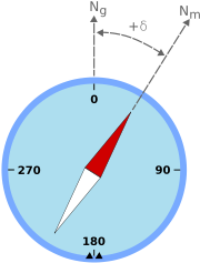
There are three main ways of stating the declination for a given location:- In a diagram
- On some maps intended for wilderness or navigational use, including the topographic mapTopographic mapA topographic map is a type of map characterized by large-scale detail and quantitative representation of relief, usually using contour lines in modern mapping, but historically using a variety of methods. Traditional definitions require a topographic map to show both natural and man-made features...
s of the U.S. Geological Survey (USGS), a diagram shows the relationship between magnetic north in the area concerned (with an arrow marked "MN") and true north (a vertical line with a five-pointed star at its top), with a label near the angle between the MN arrow and the vertical line, stating the size of the declination and of that angle, in degrees, milAngular milAn angular mil, also mil, is a unit of angle. All versions of the angular mil are approximately the same size as a trigonometric milliradian.-History:The milliradian was first identified in the mid nineteenth Century...
s, or both. (On USGS maps, the diagram is near the lower left hand corner, and the information labelled "GN" (grid north) in the same diagram is irrelevant to this discussion.)
- On some maps intended for wilderness or navigational use, including the topographic map
- As the numeric size of the angle between magnetic and true north, and the direction from true north to magnetic north.
- For instance, "10° W" would indicate that magnetic north lies 10 degrees counter-clockwise from true north.
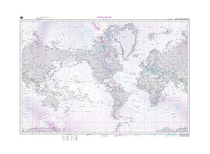
- Lines of equal declination (isogonic lines) are shown on aeronauticAeronautical chartAn aeronautical chart is a map designed to assist in navigation of aircraft, much as nautical charts do for watercraft, or a roadmap for drivers...
al and nautical chartNautical chartA nautical chart is a graphic representation of a maritime area and adjacent coastal regions. Depending on the scale of the chart, it may show depths of water and heights of land , natural features of the seabed, details of the coastline, navigational hazards, locations of natural and man-made aids...
s.
- As the signed number of degrees, where a positive angle indicates clockwise from true north and a negative counter-clockwise.
- For instance, "-10°" would indicate the same as the "10° W" just discussed.
Declination converts between true and magnetic bearings: True Bearing equals Magnetic Bearing plus Magnetic Declination. (See http://www.ngdc.noaa.gov/geomag/faqgeom.shtml question 5d
Discovering declination
An unknown declination can be discovered on location at that moment in time by reference to the celestial poleCelestial pole
The north and south celestial poles are the two imaginary points in the sky where the Earth's axis of rotation, indefinitely extended, intersects the imaginary rotating sphere of stars called the celestial sphere...
s, the axis of circular motion of stars traversing the night sky.
In the northern hemisphere, if you can see Polaris
Polaris
Polaris |Alpha]] Ursae Minoris, commonly North Star or Pole Star, also Lodestar) is the brightest star in the constellation Ursa Minor. It is very close to the north celestial pole, making it the current northern pole star....
(the North Star) the declination can be determined as the difference between the magnetic bearing and a visual bearing on the polestar. Polaris currently traces a circle 0.75° in radius around the north celestial pole, so this technique is accurate to within a degree. At high latitudes a plumb-bob
Plumb-bob
A plumb-bob or a plummet is a weight, usually with a pointed tip on the bottom, that is suspended from a string and used as a vertical reference line, or plumb-line....
is helpful to sight Polaris against a reference object close to the horizon, from which its bearing can be taken.
Learning the declination for an area
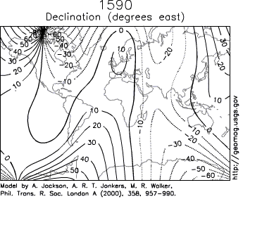
- A general isogonic chart of the world or continent can be consulted for a rough estimate of the local declination (within a few degrees)
- A prediction of the current magnetic declination for a given location (based on a worldwide empirical model of the deep flows described above) can also be obtained on-line from a web page operated by the National Geophysical Data CenterNational Geophysical Data CenterThe National Geophysical Data Center provides scientific stewardship, products and services for geophysical data describing the solid earth, marine, and solar-terrestrial environment, as well as earth observations from space....
, a division of the National Oceanic and Atmospheric AdministrationNational Oceanic and Atmospheric AdministrationThe National Oceanic and Atmospheric Administration , pronounced , like "noah", is a scientific agency within the United States Department of Commerce focused on the conditions of the oceans and the atmosphere...
of the United StatesUnited StatesThe United States of America is a federal constitutional republic comprising fifty states and a federal district...
.
One would of course rather have the real declination than a prediction. However, a map is sure to be months or years out of date, whereas the model is built with all the information available to the map makers at the start of the five-year period it is prepared for. The model reflects a highly predictable rate of change, and will usually be more accurate than a map, and almost never less accurate.
Adjustable compasses
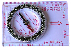
Bezel
Bezel may refer to:* Bezel setting, or bezel, the rim which encompasses and fastens a jewel, watch crystal, lens or other object* The sloping facets of the crown of a cut gem such as in diamond cutting...
that includes a graduated scale of degrees along with the four cardinal directions. Most advanced / costlier compasses include a declination adjustment. Such an adjustment moves the red "orienting arrow" (found on the base of the liquid filled cylinder that contains the needle) relative to the bezel and the baseplate. Either the cylinder will have a mark to be read against the scale of degrees on the baseplate, or a separate scale will display the current adjustment in degrees (ie, the angle by which it has been turned). In either case, the underlying concept is that for a declination of 10° W, the red orienting arrow on the cylinder must lie 10° W of 0°/N on the bezel. (Basically, in this case, you are permanently subtracting 10° from your future bearings to compensate for the -10° declination. If your declination was 10°E you would rotate the baseplate's red orienting arrow 10° E of 0°/N to compensate for the +10° declination.) In this sense, it can be said that the compass has been adjusted to indicate true north instead of magnetic north (as long as the compass remains within an area on the same isogonic line).
Non-adjustable compasses
With a compass lacking an adjustable baseplate, a careful, well-practiced, compass user can analyse the combination of declination and task, and decide whether the declination is to be added or subtracted from the known direction to determine an unknown direction.In a place where the declination needs to be subtracted from an angle measured on a map from true north to a destination, to learn the compass reading to follow (on an unadjusted compass) to walk that course, the declination needs to be added to the compass reading that a landmark lies along, to learn the direction on the map to seek the name to match the landmark with.
Navigation
On aircraft or vessels there are even three types of bearings: true, magnetic, and compass bearing. Compass error is divided into two parts, namely magnetic variation and magnetic deviationMagnetic deviation
Magnetic deviation is the error induced in a compass by local magnetic fields, which must be allowed for, along with magnetic declination, if accurate bearings are to be calculated....
, the latter originating from magnetic properties of the the vessel or aircraft. Variation and deviation are signed quantities. As discussed above, positive (easterly) variation indicates magnetic north being east of geographic north. Deviation is positive if a compass bearing mark points to the right of the related magnetic bearing.
If one knows compass bearing and wants to determine true bearing the following calculations apply:
- Compass bearingBearing (navigation)In marine navigation, a bearing is the direction one object is from another object, usually, the direction of an object from one's own vessel. In aircraft navigation, a bearing is the actual compass direction of the forward course of the aircraft...
+ deviation = magnetic bearing - Magnetic bearingBearing (navigation)In marine navigation, a bearing is the direction one object is from another object, usually, the direction of an object from one's own vessel. In aircraft navigation, a bearing is the actual compass direction of the forward course of the aircraft...
+ variation = true bearing.
Or starting from a given true bearing, the related compass bearing is obtained by:
- True bearing - variation = Magnetic bearingBearing (navigation)In marine navigation, a bearing is the direction one object is from another object, usually, the direction of an object from one's own vessel. In aircraft navigation, a bearing is the actual compass direction of the forward course of the aircraft...
- Magnetic bearing - deviation = Compass bearingBearing (navigation)In marine navigation, a bearing is the direction one object is from another object, usually, the direction of an object from one's own vessel. In aircraft navigation, a bearing is the actual compass direction of the forward course of the aircraft...
.
It is often combined with "West is Best, East is least"; that is to say, add W declinations when going True to Magnetic to Compass, and subtract E ones.
Another simple way of remembering which way to apply the correction for Continental USA is as follows:
For locations east of the agonic line (zero declination), roughly east of the Mississippi: The magnetic bearing is always bigger.
For locations west of the agonic line (zero declination), roughly west of the Mississippi: The magnetic bearing is always smaller.
Common abbreviations are:
- TC = true course;
- V = variation (of the Earth's magnetic field);
- MC = magnetic course (what the course would be in the absence of local declination);
- D = deviation caused by magnetic material (mostly iron and steel) on the vessel;
- CC = compass course.
Variation
Magnetic variation is the angle from magnetic north to true north (positive in clockwise, easterly direction) and is caused by the different locations of the Geographic North Pole and the Magnetic North Pole plus any local anomalies such as iron deposits. Variation is positive (easterly) if magnetic north (MN) is right (easterly) of geographic north (true north, TN). Variation is negative if magnetic north is left (westerly) of true north. Variation is the same for all compasses in the same location and is usually stated on good quality maps and charts, along with the date it was measured. Variation has to be added to magnetic bearing to obtain true bearing.Deviation
Magnetic deviationMagnetic deviation
Magnetic deviation is the error induced in a compass by local magnetic fields, which must be allowed for, along with magnetic declination, if accurate bearings are to be calculated....
is the angle from a given magnetic bearing to the related bearing mark of the compass. Deviation is positive if a compass bearing mark (e.g. compass north) is right of the related magnetic bearing (e.g. magnetic north) and vice versa. For example, if the boat is aligned to magnetic north and the compass' north mark points 3° more east, deviation is +3°. Deviation varies for every compass in the same location and depends on such factors as the magnetic field of the vessel, wristwatches, etc. The value will also vary depending on the orientation of the boat. Magnets and/or iron masses can be used to correct for deviation so that a particular compass will accurately give magnetic bearings. More commonly, however, a correction card will be drawn up listing errors for the compass which can then be compensated for arithmetically. Deviation has to be added to compass bearing to obtain magnetic bearing.
Air navigation
Air navigation
The basic principles of air navigation are identical to general navigation, which includes the process of planning, recording, and controlling the movement of a craft from one place to another....
, since the most simple aircraft navigation instruments are designed to determine headings by locating magnetic north through the use of a compass or similar magnetic device.
Aviation sectionals (maps / charts) and databases used for air navigation are based on True north rather than magnetic north, and the constant and significant slight changes in the actual location of magnetic north and local irregularities in the planet's magnetic field require that charts and databases be updated at least 2 times per year to reflect the current magnetic variation correction from True north.
For example, as of March 2010, near San Francisco the magnetic north is about 14.3 degrees east of True north, with the difference decreasing by about 6 minutes of arc per year.
When plotting a course, a pilot in most small planes will plot a trip using true north on a sectional (map), then, convert the true north bearings to magnetic north for in-plane navigation using the magnetic compass. During flight, the correct compass course is obtained by a deviation correction card, which is usually located in the proximity of the compass.
Radionavigation aids located on the ground, such as VOR
VHF omnidirectional range
VOR, short for VHF omnidirectional radio range, is a type of radio navigation system for aircraft. A VOR ground station broadcasts a VHF radio composite signal including the station's identifier, voice , and navigation signal. The identifier is typically a two- or three-letter string in Morse code...
s, are also checked and updated to keep them aligned with magnetic north to allow pilots to use their magnetic compasses for accurate and reliable in-plane navigation.
The Earth’s magnetic north pole is slowly heading toward Russia, according to scientists, but one of the places being affected by this is Tampa International Airport (TIA) in Tampa, Florida. Airport officials closed its main runway in the second week of January 2011, to adjust the taxiway signs accounting for the magnetic pole shift, Tampa Bay Online reports. The runway designation change was called for by the Federal Aviation Administration (FAA) to reflect a previous National Geographic News report which indicated that the magnetic pole was heading in Russia’s direction at almost 40 miles per year. TIA in Florida is closing some runways to make adjustments based on the shifting magnetic pole. Magnetic changes in Earth’s core are causing this, possibly due to “a region of rapidly changing magnetism on the core’s surface,” according to National Geographic. Normally, magnetic fields do not require adjustments to be made at airports, a FAA spokesman said. Later this month, two other runways at the Tampa airport will also be closed to update the signs to their new designations. It is not known yet if similar changes will be needed at other airports in the United States. Source: http://www.aolnews.com/2011/01/07/magnetic-north-pole-shift-affects-tampaairport/
GPS systems used for air navigation can use magnetic north or true north. In order to make them more compatible with systems that depend on magnetic north, magnetic north is often chosen, at the pilot's preference.
The GPS receiver natively reads in true north, but can elegantly calculate magnetic north based on its true position and data tables calculate the current location and direction of the north magnetic pole and (potentially) any local variations, if the GPS is set to use magnetic compass readings.
See also
- Magnetic inclination
- Magnetic deviationMagnetic deviationMagnetic deviation is the error induced in a compass by local magnetic fields, which must be allowed for, along with magnetic declination, if accurate bearings are to be calculated....
- Geomagnetism
- North Magnetic PoleNorth Magnetic PoleThe Earth's North Magnetic Pole is the point on the surface of the Northern Hemisphere at which the Earth's magnetic field points vertically downwards . Though geographically in the north, it is, by the direction of the magnetic field lines, physically the south pole of the Earth's magnetic field...
- Pole starPole starThe term "Pole Star" usually refers to Polaris, which is the current northern pole star, also known as the North Star.In general, however, a pole star is a visible star, especially a prominent one, that is approximately aligned with the Earth's axis of rotation; that is, a star whose apparent...
- Voyages of Christopher ColumbusVoyages of Christopher ColumbusIn the early modern period, the voyages of Columbus initiated European exploration and colonization of the American continents, and are thus of great significance in world history. Christopher Columbus was a navigator and an admiral for Castile, a country that later founded modern Spain...
- Shen KuoShen KuoShen Kuo or Shen Gua , style name Cunzhong and pseudonym Mengqi Weng , was a polymathic Chinese scientist and statesman of the Song Dynasty...
- L-shellL-shellThe L-shell, L-value, or McIlwain L-parameter is a parameter describing a particular set of planetary magnetic field lines. Colloquially, L-value often describes the set of magnetic field lines which cross the Earth's magnetic equator at a number of Earth-radii equal to the L-value...