
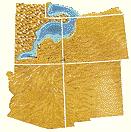
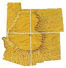
Geology of the Bryce Canyon area
Encyclopedia
Utah
Utah is a state in the Western United States. It was the 45th state to join the Union, on January 4, 1896. Approximately 80% of Utah's 2,763,885 people live along the Wasatch Front, centering on Salt Lake City. This leaves vast expanses of the state nearly uninhabited, making the population the...
shows a record of deposition that covers the last part of the Cretaceous
Cretaceous
The Cretaceous , derived from the Latin "creta" , usually abbreviated K for its German translation Kreide , is a geologic period and system from circa to million years ago. In the geologic timescale, the Cretaceous follows the Jurassic period and is followed by the Paleogene period of the...
Period and the first half of the Cenozoic
Cenozoic
The Cenozoic era is the current and most recent of the three Phanerozoic geological eras and covers the period from 65.5 mya to the present. The era began in the wake of the Cretaceous–Tertiary extinction event at the end of the Cretaceous that saw the demise of the last non-avian dinosaurs and...
era in that part of North America
North America
North America is a continent wholly within the Northern Hemisphere and almost wholly within the Western Hemisphere. It is also considered a northern subcontinent of the Americas...
. The ancient depositional environment
Sedimentary depositional environment
In geology, sedimentary depositional environment describes the combination of physical, chemical and biological processes associated with the deposition of a particular type of sediment and, therefore, the rock types that will be formed after lithification, if the sediment is preserved in the rock...
of the region around what is now Bryce Canyon National Park
Bryce Canyon National Park
Bryce Canyon National Park is a national park located in southwestern Utah in the United States. The major feature of the park is Bryce Canyon which, despite its name, is not a canyon but a giant natural amphitheater created by erosion along the eastern side of the Paunsaugunt Plateau...
varied from the warm shallow sea (called the Cretaceous Seaway) in which the Dakota Sandstone and the Tropic Shale were deposited to the cool stream
Stream
A stream is a body of water with a current, confined within a bed and stream banks. Depending on its locale or certain characteristics, a stream may be referred to as a branch, brook, beck, burn, creek, "crick", gill , kill, lick, rill, river, syke, bayou, rivulet, streamage, wash, run or...
s and lakes that contributed sediment to the colorful Claron Formation that dominates the park's amphitheaters.
Other formations were also formed but were mostly eroded
Erosion
Erosion is when materials are removed from the surface and changed into something else. It only works by hydraulic actions and transport of solids in the natural environment, and leads to the deposition of these materials elsewhere...
following uplift from the Laramide orogeny
Laramide orogeny
The Laramide orogeny was a period of mountain building in western North America, which started in the Late Cretaceous, 70 to 80 million years ago, and ended 35 to 55 million years ago. The exact duration and ages of beginning and end of the orogeny are in dispute, as is the cause. The Laramide...
which started around 70 million years ago (mya). This event created the Rocky Mountains
Rocky Mountains
The Rocky Mountains are a major mountain range in western North America. The Rocky Mountains stretch more than from the northernmost part of British Columbia, in western Canada, to New Mexico, in the southwestern United States...
far to the east and helped to close the sea that covered the area. A large part of western North America started to stretch itself into the nearby Basin and Range
Basin and Range
The Basin and Range Province is a vast physiographic region defined by a unique topographic expression. Basin and Range topography is characterized by abrupt changes in elevation, alternating between narrow faulted mountain chains and flat arid valleys or basins...
topography around 15 mya. While not part of this region, the greater Bryce area was stretched into the High Plateaus by the same forces. Uplift of the Colorado Plateau
Colorado Plateau
The Colorado Plateau, also called the Colorado Plateau Province, is a physiographic region of the Intermontane Plateaus, roughly centered on the Four Corners region of the southwestern United States. The province covers an area of 337,000 km2 within western Colorado, northwestern New Mexico,...
s and the opening of the Gulf of California
Gulf of California
The Gulf of California is a body of water that separates the Baja California Peninsula from the Mexican mainland...
by 5 mya changed the drainage of the Colorado River
Colorado River
The Colorado River , is a river in the Southwestern United States and northwestern Mexico, approximately long, draining a part of the arid regions on the western slope of the Rocky Mountains. The watershed of the Colorado River covers in parts of seven U.S. states and two Mexican states...
and its tributaries, including the Paria River
Paria River
The Paria River is a tributary of the Colorado River, approximately long, in southern Utah and northern Arizona in the United States. It drains a rugged and arid region northwest of the Colorado, flowing through roadless slot canyons along part of its course....
, which is eroding headward in between two plateaus adjacent to the park. The uplift caused vertical joints to form which were later preferentially eroded to form the free-standing pinnacles called hoodoo
Hoodoo (geology)
A hoodoo is a tall, thin spire of rock that protrudes from the bottom of an arid drainage basin or badland. Hoodoos consist of relatively soft rock topped by harder, less easily eroded stone that protects each column from the elements...
s, badlands, and monolith
Monolith
A monolith is a geological feature such as a mountain, consisting of a single massive stone or rock, or a single piece of rock placed as, or within, a monument...
s we see today.
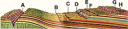
The formations exposed in the area of the park are part of the Grand Staircase
Grand Staircase
For the similarly named structure on the RMS Titanic, see Grand Staircase of the TitanicFor the stairs in the White House see Grand Staircase ...
. The oldest members of this supersequence of rock units are exposed in the Grand Canyon
Grand Canyon
The Grand Canyon is a steep-sided canyon carved by the Colorado River in the United States in the state of Arizona. It is largely contained within the Grand Canyon National Park, the 15th national park in the United States...
, the intermediate ones in Zion National Park
Zion National Park
Zion National Park is located in the Southwestern United States, near Springdale, Utah. A prominent feature of the park is Zion Canyon, which is 15 miles long and up to half a mile deep, cut through the reddish and tan-colored Navajo Sandstone by the North Fork of the Virgin River...
, and its youngest parts are laid bare in Bryce Canyon area. A small amount of overlap occurs in and around each park.
Grand Staircase
Rock (geology)
In geology, rock or stone is a naturally occurring solid aggregate of minerals and/or mineraloids.The Earth's outer solid layer, the lithosphere, is made of rock. In general rocks are of three types, namely, igneous, sedimentary, and metamorphic...
exposed in Bryce Canyon are about 100 million years younger than those in nearby Zion National Park
Zion National Park
Zion National Park is located in the Southwestern United States, near Springdale, Utah. A prominent feature of the park is Zion Canyon, which is 15 miles long and up to half a mile deep, cut through the reddish and tan-colored Navajo Sandstone by the North Fork of the Virgin River...
, and the rocks exposed in Zion are younger than those in the Grand Canyon
Grand Canyon
The Grand Canyon is a steep-sided canyon carved by the Colorado River in the United States in the state of Arizona. It is largely contained within the Grand Canyon National Park, the 15th national park in the United States...
to the south.
There are, however, shared rock units between all three, creating a supersequence of formations that geologists call the Grand Staircase. Together the formations of the Grand Staircase record nearly 2000 million years of the Earth
Earth
Earth is the third planet from the Sun, and the densest and fifth-largest of the eight planets in the Solar System. It is also the largest of the Solar System's four terrestrial planets...
's history. Bryce Canyon's formations are the youngest known units in the Grand Staircase. Younger rock units, if they ever existed, have been removed by erosion
Erosion
Erosion is when materials are removed from the surface and changed into something else. It only works by hydraulic actions and transport of solids in the natural environment, and leads to the deposition of these materials elsewhere...
.
Advance
In the CretaceousCretaceous
The Cretaceous , derived from the Latin "creta" , usually abbreviated K for its German translation Kreide , is a geologic period and system from circa to million years ago. In the geologic timescale, the Cretaceous follows the Jurassic period and is followed by the Paleogene period of the...
a shallow seaway spread into the interior of North America
North America
North America is a continent wholly within the Northern Hemisphere and almost wholly within the Western Hemisphere. It is also considered a northern subcontinent of the Americas...
from the Gulf of Mexico
Gulf of Mexico
The Gulf of Mexico is a partially landlocked ocean basin largely surrounded by the North American continent and the island of Cuba. It is bounded on the northeast, north and northwest by the Gulf Coast of the United States, on the southwest and south by Mexico, and on the southeast by Cuba. In...
in the south into Utah
Utah
Utah is a state in the Western United States. It was the 45th state to join the Union, on January 4, 1896. Approximately 80% of Utah's 2,763,885 people live along the Wasatch Front, centering on Salt Lake City. This leaves vast expanses of the state nearly uninhabited, making the population the...
and later to the Arctic Ocean
Arctic Ocean
The Arctic Ocean, located in the Northern Hemisphere and mostly in the Arctic north polar region, is the smallest and shallowest of the world's five major oceanic divisions...
in the far north. Geologists call this shallow sea the Cretaceous Seaway or Western Interior Seaway. The seaway divided North America into two halves; an eastern portion dominated by the already ancient Appalachian Mountains
Appalachian Mountains
The Appalachian Mountains #Whether the stressed vowel is or ,#Whether the "ch" is pronounced as a fricative or an affricate , and#Whether the final vowel is the monophthong or the diphthong .), often called the Appalachians, are a system of mountains in eastern North America. The Appalachians...
and a western part composed primarily of the still growing Sevier Mountains; formed from shallow thrust fault
Thrust fault
A thrust fault is a type of fault, or break in the Earth's crust across which there has been relative movement, in which rocks of lower stratigraphic position are pushed up and over higher strata. They are often recognized because they place older rocks above younger...
ing caused by the Sevier orogeny
Sevier orogeny
The Sevier orogeny was a mountain-building event that affected western North America from Canada to the north to Mexico to the south. This orogeny was the result of convergent boundary tectonic activity between approximately 140 million years ago and 50 Ma. The Sevier River area of central Utah...
. As the shoreline moved back and forth, the Bryce area alternated from being part of the Sevier landmass to being under the Cretaceous Seaway. Alternating layers of nonmarine, intertidal, and marine sediments lay on top of each other as a result.
Conglomerate
Conglomerate (geology)
A conglomerate is a rock consisting of individual clasts within a finer-grained matrix that have become cemented together. Conglomerates are sedimentary rocks consisting of rounded fragments and are thus differentiated from breccias, which consist of angular clasts...
, siltstone
Siltstone
Siltstone is a sedimentary rock which has a grain size in the silt range, finer than sandstone and coarser than claystones.- Description :As its name implies, it is primarily composed of silt sized particles, defined as grains 1/16 - 1/256 mm or 4 to 8 on the Krumbein phi scale...
, and fossil
Fossil
Fossils are the preserved remains or traces of animals , plants, and other organisms from the remote past...
-rich sandstone
Sandstone
Sandstone is a sedimentary rock composed mainly of sand-sized minerals or rock grains.Most sandstone is composed of quartz and/or feldspar because these are the most common minerals in the Earth's crust. Like sand, sandstone may be any colour, but the most common colours are tan, brown, yellow,...
that together are up to 300 feet (91.4 m) thick mark the arrival of the Cretaceous Seaway. Called the Dakota Sandstone
Dakota Sandstone
The Dakota Sandstone is a general term for an ill-defined early Cretaceous formation of the Rocky Mountains and Great Plains. It consists of sandy, shallow-marine deposits with intermittent mud flat sediments, and occasional stream deposits...
, it is the oldest formation exposed in the Bryce Canyon area but the youngest one exposed in the Zion and Kolob canyons area to the southwest. Abundant amounts of petrified wood
Petrified wood
Petrified wood is the name given to a special type of fossilized remains of terrestrial vegetation. It is the result of a tree having turned completely into stone by the process of permineralization...
, oyster
Oyster
The word oyster is used as a common name for a number of distinct groups of bivalve molluscs which live in marine or brackish habitats. The valves are highly calcified....
beds containing millions of fossils and coal
Coal
Coal is a combustible black or brownish-black sedimentary rock usually occurring in rock strata in layers or veins called coal beds or coal seams. The harder forms, such as anthracite coal, can be regarded as metamorphic rock because of later exposure to elevated temperature and pressure...
are all found in the Dakota. In the Bryce Canyon area this formation can be seen in the Paria Valley where it is found as a lithified blanket sand
Sand
Sand is a naturally occurring granular material composed of finely divided rock and mineral particles.The composition of sand is highly variable, depending on the local rock sources and conditions, but the most common constituent of sand in inland continental settings and non-tropical coastal...
that probably accumulated on beach
Beach
A beach is a geological landform along the shoreline of an ocean, sea, lake or river. It usually consists of loose particles which are often composed of rock, such as sand, gravel, shingle, pebbles or cobblestones...
es, in lagoon
Lagoon
A lagoon is a body of shallow sea water or brackish water separated from the sea by some form of barrier. The EU's habitat directive defines lagoons as "expanses of shallow coastal salt water, of varying salinity or water volume, wholly or partially separated from the sea by sand banks or shingle,...
s, and vast coal-producing swamp
Swamp
A swamp is a wetland with some flooding of large areas of land by shallow bodies of water. A swamp generally has a large number of hammocks, or dry-land protrusions, covered by aquatic vegetation, or vegetation that tolerates periodical inundation. The two main types of swamp are "true" or swamp...
s as the Cretaceous Seaway transgressed (advanced inland) over the region and later retreated. It sits unconformably on much older Jurassic
Jurassic
The Jurassic is a geologic period and system that extends from about Mya to Mya, that is, from the end of the Triassic to the beginning of the Cretaceous. The Jurassic constitutes the middle period of the Mesozoic era, also known as the age of reptiles. The start of the period is marked by...
formations that are not exposed in the immediate area (see geology of the Zion and Kolob canyons area
Geology of the Zion and Kolob canyons area
The geology of the Zion and Kolob canyons area includes nine known exposed formations, all visible in Zion National Park in the U.S. state of Utah. Together, these formations represent about 150 million years of mostly Mesozoic-aged sedimentation in that part of North America...
for a discussion about these older sediments).
Mud
Mud
Mud is a mixture of water and some combination of soil, silt, and clay. Ancient mud deposits harden over geological time to form sedimentary rock such as shale or mudstone . When geological deposits of mud are formed in estuaries the resultant layers are termed bay muds...
and silt
Silt
Silt is granular material of a size somewhere between sand and clay whose mineral origin is quartz and feldspar. Silt may occur as a soil or as suspended sediment in a surface water body...
were deposited on top of the Dakota Formation as the seaway became deeper and calmer in the area. The resulting dark gray to black Tropic Shale records the maximum transgression of the seaway into Utah and is 1000 feet (304.8 m) thick in the Paria Amphitheater. It forms the unvegetated badlands seen in the Tropic Valley and is perhaps the most fossil-rich formation in the area; containing numerous straight-shelled and coiled ammonite
Ammonite
Ammonite, as a zoological or paleontological term, refers to any member of the Ammonoidea an extinct subclass within the Molluscan class Cephalopoda which are more closely related to living coleoids Ammonite, as a zoological or paleontological term, refers to any member of the Ammonoidea an extinct...
s.
Retreat
The Cretaceous Seaway was already retreating east and to the south by the time the locally 1700 feet (518.2 m) thick Straight Cliffs FormationStraight Cliffs Formation
The Straight Cliffs Formation is a Mesozoic geologic formation. Dinosaur remains diagnostic to the genus level are among the fossils that have been recovered from the formation.-Paleofauna:* cf. Paronychodon sp....
was deposited. Its members represent various stages in this process. The cliff-forming sandstone of the Tibbet Canyon Member was conformably deposited on top of the Tropic Shale in shallow marine and later near shore environments. Shale and sandstone from the Smoky Hollow Member were deposited on top of its basal layer of coal-rich mudstone in coastal swamps and lagoons on the shore of the seaway. While the alternating layers of shale and sandstone mixed with massive coal deposits of the John Henry Member were laid down in swamps, lagoons and fluvial
Fluvial
Fluvial is used in geography and Earth science to refer to the processes associated with rivers and streams and the deposits and landforms created by them...
environments one member, the Drip Tank, is not found in the Bryce Canyon area. This formation erodes into almost unclimbable cliffs and escarpments of whitish to yellow-gray sandstones with comparatively thin interbedded layers of shale and mudstone. Shark teeth are found in the lower parts of the formation.
Lakes and east-flowing rivers became the dominant resting place for sediment following the retreat of the Cretaceous Seaway. The shales and sandstones of the locally 700 feet (213.4 m) thick Wahweap Formation
Wahweap Formation
The Wahweap Formation of the Grand Staircase-Escelante National Monument is a geological formation in southern Utah and northern Arizona, around the Lake Powell region, whose strata date back to the Late Cretaceous...
were deposited in moving water (fluvial setting). This formation is part of the Grey Cliffs of the Grand Staircase mentioned previously. It contains abundant fossils of vertebrate
Vertebrate
Vertebrates are animals that are members of the subphylum Vertebrata . Vertebrates are the largest group of chordates, with currently about 58,000 species described. Vertebrates include the jawless fishes, bony fishes, sharks and rays, amphibians, reptiles, mammals, and birds...
s, including dinosaur
Dinosaur
Dinosaurs are a diverse group of animals of the clade and superorder Dinosauria. They were the dominant terrestrial vertebrates for over 160 million years, from the late Triassic period until the end of the Cretaceous , when the Cretaceous–Paleogene extinction event led to the extinction of...
s such as the hadrosaurs.
Flood plains uplift and erode
Kaiparowits Formation
The Kaiparowits Formation is a sedimentary rock formation found in the Kaiparowits Plateau in Grand Staircase-Escalante National Monument, in the southern part of Utah in the western United States. It is over 2800 feet thick, and is Campanian in age...
. This formation is up to 100 feet (30.5 m) thick in the Bryce Canyon area but other parts of the Kaiparowits in the region are several hundreds of feet (tens of meters) thick. Two formations, the Canaan Peak and the Pine Hollow, sit on top of the Kaiparowits elsewhere in the region but are absent in the Bryce Canyon area. The sandstones and conglomerates of these formations record stream and river deposition starting in the Paleocene
Paleocene
The Paleocene or Palaeocene, the "early recent", is a geologic epoch that lasted from about . It is the first epoch of the Palaeogene Period in the modern Cenozoic Era...
epoch.
Uplift caused by a mountain
Mountain
Image:Himalaya_annotated.jpg|thumb|right|The Himalayan mountain range with Mount Everestrect 58 14 160 49 Chomo Lonzorect 200 28 335 52 Makalurect 378 24 566 45 Mount Everestrect 188 581 920 656 Tibetan Plateaurect 250 406 340 427 Rong River...
-building episode called the Laramide orogeny
Laramide orogeny
The Laramide orogeny was a period of mountain building in western North America, which started in the Late Cretaceous, 70 to 80 million years ago, and ended 35 to 55 million years ago. The exact duration and ages of beginning and end of the orogeny are in dispute, as is the cause. The Laramide...
lasted from the late Cretaceous around 70 mya to the early Paleocene. This hoisted the once lower uplands skyward while low-lying basins
Sedimentary basin
The term sedimentary basin is used to refer to any geographical feature exhibiting subsidence and consequent infilling by sedimentation. As the sediments are buried, they are subjected to increasing pressure and begin the process of lithification...
between them gradually subsided. Compression from the Laramide event deformed the land in the area to form the up to 5° dipping Bryce Canyon Anticline. All of the Canaan Peak, Pine Hollow, Kaiparowits, and Waheap formations, along with part of the underlying Straight Cliffs, were removed from the anticline's crest by erosion before the Claron Formation was deposited. An angular unconformity therefore exists along the anticline's crest. The park also sits on the western gently dipping flank of the much larger Kaibab uplift, which was also formed as a result of the Laramide.
Claron flood plain and lake system
Uplift from the Laramide paused briefly in the EoceneEocene
The Eocene Epoch, lasting from about 56 to 34 million years ago , is a major division of the geologic timescale and the second epoch of the Paleogene Period in the Cenozoic Era. The Eocene spans the time from the end of the Palaeocene Epoch to the beginning of the Oligocene Epoch. The start of the...
. Meandering streams flowed slowly over the resulting broad and almost featureless plains. Periodic but extensive flood
Flood
A flood is an overflow of an expanse of water that submerges land. The EU Floods directive defines a flood as a temporary covering by water of land not normally covered by water...
s inundated large areas perhaps once every 1,000 years; spreading mud, cobbles and fine silt over the plains. Erosion
Erosion
Erosion is when materials are removed from the surface and changed into something else. It only works by hydraulic actions and transport of solids in the natural environment, and leads to the deposition of these materials elsewhere...
incised these deposits between flood events and plant
Plant
Plants are living organisms belonging to the kingdom Plantae. Precise definitions of the kingdom vary, but as the term is used here, plants include familiar organisms such as trees, flowers, herbs, bushes, grasses, vines, ferns, mosses, and green algae. The group is also called green plants or...
growth was abundant. Oxidation of the iron
Iron
Iron is a chemical element with the symbol Fe and atomic number 26. It is a metal in the first transition series. It is the most common element forming the planet Earth as a whole, forming much of Earth's outer and inner core. It is the fourth most common element in the Earth's crust...
in the mud and silt turned the soil into hematite
Hematite
Hematite, also spelled as haematite, is the mineral form of iron oxide , one of several iron oxides. Hematite crystallizes in the rhombohedral system, and it has the same crystal structure as ilmenite and corundum...
, giving it a pink and red hue. These sediments were later lithified into the up to 700 feet (213.4 m) thick Pink Member of the locally Eocene-aged Claron Formation (previously called the Wasatch Formation). Channelized conglomerates of this member can be easily seen in Red Canyon along State Route 12 while its silt and mudstones compose most of the park's fragile and colorful spires called hoodoos
Hoodoo (geology)
A hoodoo is a tall, thin spire of rock that protrudes from the bottom of an arid drainage basin or badland. Hoodoos consist of relatively soft rock topped by harder, less easily eroded stone that protects each column from the elements...
. Geologist Clarence Dutton
Clarence Dutton
Clarence Edward Dutton was an American geologist and US Army officer. Dutton was born in Wallingford, Connecticut on May 15, 1841...
called the iron oxide
Iron oxide
Iron oxides are chemical compounds composed of iron and oxygen. All together, there are sixteen known iron oxides and oxyhydroxides.Iron oxides and oxide-hydroxides are widespread in nature, play an important role in many geological and biological processes, and are widely utilized by humans, e.g.,...
-rich lower member of the Claron the Pink Cliffs
Pink Cliffs
The Pink Cliffs are a series of highly-dissected cliffs, approximately 35 mi long, along the southeast edge of the Paunsaugunt Plateau in southwestern Utah in the United States...
series due to its colorful appearance.
Lake
A lake is a body of relatively still fresh or salt water of considerable size, localized in a basin, that is surrounded by land. Lakes are inland and not part of the ocean and therefore are distinct from lagoons, and are larger and deeper than ponds. Lakes can be contrasted with rivers or streams,...
s and associated deltas covered several thousand square miles of what is now northwest Colorado
Colorado
Colorado is a U.S. state that encompasses much of the Rocky Mountains as well as the northeastern portion of the Colorado Plateau and the western edge of the Great Plains...
and southwest Utah
Utah
Utah is a state in the Western United States. It was the 45th state to join the Union, on January 4, 1896. Approximately 80% of Utah's 2,763,885 people live along the Wasatch Front, centering on Salt Lake City. This leaves vast expanses of the state nearly uninhabited, making the population the...
and Wyoming
Wyoming
Wyoming is a state in the mountain region of the Western United States. The western two thirds of the state is covered mostly with the mountain ranges and rangelands in the foothills of the Eastern Rocky Mountains, while the eastern third of the state is high elevation prairie known as the High...
. These lakes existed from the Paleocene to mid Oligocene
Oligocene
The Oligocene is a geologic epoch of the Paleogene Period and extends from about 34 million to 23 million years before the present . As with other older geologic periods, the rock beds that define the period are well identified but the exact dates of the start and end of the period are slightly...
but did not spread to the Bryce Canyon area until Eocene time. Large quantities of lakebed sediments were laid down in this system during the 20 million years of its existence from about 60 to 40 mya. Climate change
Climate change
Climate change is a significant and lasting change in the statistical distribution of weather patterns over periods ranging from decades to millions of years. It may be a change in average weather conditions or the distribution of events around that average...
and cycles caused the lakes in the system to expand and shrink through time. As they did so, they left beds of differing thickness and composition stacked atop one another;
- various sand and cobble deposits near shore,
- calciumCalciumCalcium is the chemical element with the symbol Ca and atomic number 20. It has an atomic mass of 40.078 amu. Calcium is a soft gray alkaline earth metal, and is the fifth-most-abundant element by mass in the Earth's crust...
-poor muds further from shore, - calcium-rich mud in deeper water, and
- pure limey oozes were deposited in the deepest waters.
The limey ooses and mud were later lithified into the limestone and interbedded siltstone of the up to 300 foot (90 m) thick White Member of the Claron. This member erodes into white-colored monolith
Monolith
A monolith is a geological feature such as a mountain, consisting of a single massive stone or rock, or a single piece of rock placed as, or within, a monument...
s that are only found at the highest elevations of the Paunsaugunt Plateau
Paunsaugunt Plateau
The Paunsaugunt Plateau is a dissected plateau, rising to an elevation of , in southwestern Utah in the United States. Located in northern Kane County and southwestern Garfield County, it is approximately wide, and extends southward from the Sevier Plateau approximately , terminating in the Pink...
. Fossils are rare in the White Member and mainly consist of freshwater snail
Snail
Snail is a common name applied to most of the members of the molluscan class Gastropoda that have coiled shells in the adult stage. When the word is used in its most general sense, it includes sea snails, land snails and freshwater snails. The word snail without any qualifier is however more often...
s and clam
Clam
The word "clam" can be applied to freshwater mussels, and other freshwater bivalves, as well as marine bivalves.In the United States, "clam" can be used in several different ways: one, as a general term covering all bivalve molluscs...
s, indicating that the lakes supported little life. Most arches and natural bridges in the park, including the famous Natural Bridge
Natural Bridges National Monument
Natural Bridges National Monument is a U.S. National Monument located about north west of the Four Corners boundary of southeast Utah, in the western United States, at the junction of White Canyon and Armstrong Canyon, part of the Colorado River drainage...
, were carved from sandstone beds in the Claron.
Marysvale volcanics
A gap in the geologic record following deposition of the Claron Formation was interrupted 34 to 31 mya by eruptions from the nearby Marysvale volcanic fieldMarysvale Volcanic Field
The Marysvale volcanic field is located in southwestern Utah, United States.One of the largest volcanic fields in the western United States, the Marysvale straddles the Colorado Plateau-Great Basin transition zone...
, which is located northwest of the park. Volcanic ash
Volcanic ash
Volcanic ash consists of small tephra, which are bits of pulverized rock and glass created by volcanic eruptions, less than in diameter. There are three mechanisms of volcanic ash formation: gas release under decompression causing magmatic eruptions; thermal contraction from chilling on contact...
and lava
Lava
Lava refers both to molten rock expelled by a volcano during an eruption and the resulting rock after solidification and cooling. This molten rock is formed in the interior of some planets, including Earth, and some of their satellites. When first erupted from a volcanic vent, lava is a liquid at...
from these flows are found less than 20 miles (32.2 km) from Bryce Canyon but at least some volcanic material was likely deposited directly in the park area only to be later removed by erosion.
Most of the activity at the Marysvale volcanic field occurred during three separate intervals; ~34–22 mya, 22–14 mya and 9–5 mya. Dacite
Dacite
Dacite is an igneous, volcanic rock. It has an aphanitic to porphyritic texture and is intermediate in composition between andesite and rhyolite. The relative proportions of feldspars and quartz in dacite, and in many other volcanic rocks, are illustrated in the QAPF diagram...
s and andesite
Andesite
Andesite is an extrusive igneous, volcanic rock, of intermediate composition, with aphanitic to porphyritic texture. In a general sense, it is the intermediate type between basalt and dacite. The mineral assemblage is typically dominated by plagioclase plus pyroxene and/or hornblende. Magnetite,...
s were erupted above an evolving batholith
Batholith
A batholith is a large emplacement of igneous intrusive rock that forms from cooled magma deep in the Earth's crust...
in the first interval. Crystal-rich ash from the 27 million year old (myo) Three Creeks caldera, 24 myo Big John caldera and 23 myo Monroe Peak caldera hardened into tuff
Tuff
Tuff is a type of rock consisting of consolidated volcanic ash ejected from vents during a volcanic eruption. Tuff is sometimes called tufa, particularly when used as construction material, although tufa also refers to a quite different rock. Rock that contains greater than 50% tuff is considered...
. The second and third intervals saw eruptions of great quantities of rhyolite
Rhyolite
This page is about a volcanic rock. For the ghost town see Rhyolite, Nevada, and for the satellite system, see Rhyolite/Aquacade.Rhyolite is an igneous, volcanic rock, of felsic composition . It may have any texture from glassy to aphanitic to porphyritic...
s. Alkali
Alkali
In chemistry, an alkali is a basic, ionic salt of an alkali metal or alkaline earth metal element. Some authors also define an alkali as a base that dissolves in water. A solution of a soluble base has a pH greater than 7. The adjective alkaline is commonly used in English as a synonym for base,...
-rich rhyolite erupted in the second interval from the 19 myo Mount Belknap caldera.
The Marysvale volcanic field collapsed under its own weight around 20 mya; likely due to weaknesses in the evaporite
Evaporite
Evaporite is a name for a water-soluble mineral sediment that result from concentration and crystallization by evaporation from an aqueous solution. There are two types of evaporate deposits, marine which can also be described as ocean deposits, and non-marine which are found in standing bodies of...
s of the Carmel Formation
Carmel Formation
The Carmel Formation is a geologic formation in the San Rafael Group that is spread across the U.S. states of Wyoming, Utah, Colorado, north east Arizona and New Mexico...
some 5000 feet (1,524 m) below. Folding and faulting of the Claron Formation from the collapse created Ruby's Inn thrust. A slight downwarp running east–west and perpendicular to the thrust motion called the Bryce syncline was also created. Volcanic activity in the Marysvale and Bryce area ceased some 500,000 years ago. Basalt
Basalt
Basalt is a common extrusive volcanic rock. It is usually grey to black and fine-grained due to rapid cooling of lava at the surface of a planet. It may be porphyritic containing larger crystals in a fine matrix, or vesicular, or frothy scoria. Unweathered basalt is black or grey...
ic rocks of the same age can be seen along the Sevier Fault near the entrance to Red Canyon; the dark colored volcanic rocks have been displaced by the fault some 900 feet (274.3 m) and are now in direct contact with the much older Claron Formation.
Formation of the High Plateaus
Oligocene
The Oligocene is a geologic epoch of the Paleogene Period and extends from about 34 million to 23 million years before the present . As with other older geologic periods, the rock beds that define the period are well identified but the exact dates of the start and end of the period are slightly...
or Miocene
Miocene
The Miocene is a geological epoch of the Neogene Period and extends from about . The Miocene was named by Sir Charles Lyell. Its name comes from the Greek words and and means "less recent" because it has 18% fewer modern sea invertebrates than the Pliocene. The Miocene follows the Oligocene...
-aged Boat Mesa Conglomerate and the Pliocene
Pliocene
The Pliocene Epoch is the period in the geologic timescale that extends from 5.332 million to 2.588 million years before present. It is the second and youngest epoch of the Neogene Period in the Cenozoic Era. The Pliocene follows the Miocene Epoch and is followed by the Pleistocene Epoch...
to early Pleistocene
Pleistocene
The Pleistocene is the epoch from 2,588,000 to 11,700 years BP that spans the world's recent period of repeated glaciations. The name pleistocene is derived from the Greek and ....
-aged Sevier River Formation. The Boat Mesa is made mostly of conglomerates with minor amounts of sandstone and some limestone from lakes, representing stream and overbank flood deposits. The brownish-gray sandstone and gravels of the Sevier River Formation were laid down in valleys that were part of the ancestral Sevier River
Sevier River
The Sevier River , extending , is the longest Utah river entirely in the state and drains an extended chain of mountain farming valleys to the intermittent Sevier Lake...
drainage system.
Around 15 mya in Miocene
Miocene
The Miocene is a geological epoch of the Neogene Period and extends from about . The Miocene was named by Sir Charles Lyell. Its name comes from the Greek words and and means "less recent" because it has 18% fewer modern sea invertebrates than the Pliocene. The Miocene follows the Oligocene...
time, tensional forces in Nevada
Nevada
Nevada is a state in the western, mountain west, and southwestern regions of the United States. With an area of and a population of about 2.7 million, it is the 7th-largest and 35th-most populous state. Over two-thirds of Nevada's people live in the Las Vegas metropolitan area, which contains its...
to the west were so great that the crust was spread thin, creating the Basin and Range Province. These same forces segmented what is now the western part of the Colorado Plateau
Colorado Plateau
The Colorado Plateau, also called the Colorado Plateau Province, is a physiographic region of the Intermontane Plateaus, roughly centered on the Four Corners region of the southwestern United States. The province covers an area of 337,000 km2 within western Colorado, northwestern New Mexico,...
into nine different smaller plateaus, including the Paunsaugunt
Paunsaugunt Plateau
The Paunsaugunt Plateau is a dissected plateau, rising to an elevation of , in southwestern Utah in the United States. Located in northern Kane County and southwestern Garfield County, it is approximately wide, and extends southward from the Sevier Plateau approximately , terminating in the Pink...
that the park sits astride. Long, north–south-trending normal faults were either newly created or reactivated from older pre-existing faults; a plateau rose on one side of each fault while valleys subsided on the other as the crust was extended in an east-west direction. Two of these faults bound the Paunsaugunt Plateau; the Sevier on the west and the Paunsaugunt on the east. Movement along these two faults has displaced the Claron Formation by 2,000 feet (600 m) relative to the Paria and Sevier valleys.
The Hurricane Fault marks the west edge of the Markagunt Plateau
Markagunt Plateau
The Markagunt Plateau is an plateau located in southwestern Utah between Interstate 15 and U.S. Route 89. It is one of the plateaus that make up the High Plateaus Section of the Colorado Plateau. The plateau encompasses Cedar Breaks National Monument and is part of Cedar Mountain District of...
and is the topographic boundary between the Basin and Range and the Colorado Plateaus provinces. Cedar Breaks National Monument
Cedar Breaks National Monument
Cedar Breaks National Monument is a U.S. National Monument located in the U.S. state of Utah near Cedar City. Cedar Breaks is a natural amphitheater canyon, stretching across , with a depth of over . The elevation of the rim of the canyon is over above sea level.The eroded rock of the canyon is...
, which shares almost the same exposed geology and erosional features as Bryce Canyon National Park, sits on the west edge of the Markagunt.
The entire Colorado Plateau then started to uplift from near sea level
Sea level
Mean sea level is a measure of the average height of the ocean's surface ; used as a standard in reckoning land elevation...
to several thousand feet (over a kilometer) in elevation. An alternate theory is that the Laramide orogeny uplifted what is today the Basin and Range and the Colorado Plateau and that the tensional forces that formed the Basin and Range caused that region to subside relative to the Colorado Plateau. Whatever the order of events were, the High Plateaus region of the Colorado Plateau were by now nearly complete.
Modern drainage and erosion
Drainage of the Colorado Plateau was significantly altered by the opening of the Gulf of CaliforniaGulf of California
The Gulf of California is a body of water that separates the Baja California Peninsula from the Mexican mainland...
. Rift
Rift
In geology, a rift or chasm is a place where the Earth's crust and lithosphere are being pulled apart and is an example of extensional tectonics....
ing tore Baja California Peninsula
Baja California Peninsula
The Baja California peninsula , is a peninsula in northwestern Mexico. Its land mass separates the Pacific Ocean from the Gulf of California. The Peninsula extends from Mexicali, Baja California in the north to Cabo San Lucas, Baja California Sur in the south.The total area of the Baja California...
northwestward from the Mexican
Mexico
The United Mexican States , commonly known as Mexico , is a federal constitutional republic in North America. It is bordered on the north by the United States; on the south and west by the Pacific Ocean; on the southeast by Guatemala, Belize, and the Caribbean Sea; and on the east by the Gulf of...
mainland starting some 10 to 5 mya. The ancestral Colorado River
Colorado River
The Colorado River , is a river in the Southwestern United States and northwestern Mexico, approximately long, draining a part of the arid regions on the western slope of the Rocky Mountains. The watershed of the Colorado River covers in parts of seven U.S. states and two Mexican states...
responded to the regional downwarping by taking a shortcut to the sea by flowing into the new gulf. This significantly decreased the distance from the river's headwaters and its delta at the sea. Water in the Colorado and its tributaries moved faster as a result and cut down deeper, creating the canyonland topography.
Formation of approximately the current depth of the Colorado River's Grand Canyon
Grand Canyon
The Grand Canyon is a steep-sided canyon carved by the Colorado River in the United States in the state of Arizona. It is largely contained within the Grand Canyon National Park, the 15th national park in the United States...
by 1.2 mya further caused its tributaries to cut down even deeper. Headward erosion
Headward erosion
Headward erosion is a fluvial process of erosion that lengthens a stream, a valley or a gully at its head and also enlarges its drainage basin. The stream erodes away at the rock and soil at its headwaters in the opposite direction that it flows. Once a stream has begun to cut back, the erosion is...
of one of those tributaries, the Paria River
Paria River
The Paria River is a tributary of the Colorado River, approximately long, in southern Utah and northern Arizona in the United States. It drains a rugged and arid region northwest of the Colorado, flowing through roadless slot canyons along part of its course....
, eroded north-northwestward toward what is now Paria Amphitheater. The river took a route roughly parallel to and east of the Paunsaugunt Fault. Erosion from snow and rain that fall directly on the east-facing rim of the Paunsaugunt Plateau forms gullies that widen into alcoves and amphitheaters while differential erosion and frost wedging create the hoodoos
Hoodoo (geology)
A hoodoo is a tall, thin spire of rock that protrudes from the bottom of an arid drainage basin or badland. Hoodoos consist of relatively soft rock topped by harder, less easily eroded stone that protects each column from the elements...
. Streams on the plateau do not contribute to the formation of alcoves or amphitheaters because they flow away from the rim. Erosion continues in this fashion today.
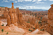
Hoodoo formation in Bryce Canyon

Carbon dioxide
Carbon dioxide is a naturally occurring chemical compound composed of two oxygen atoms covalently bonded to a single carbon atom...
it forms a weak solution of carbonic acid
Carbonic acid
Carbonic acid is the inorganic compound with the formula H2CO3 . It is also a name sometimes given to solutions of carbon dioxide in water, because such solutions contain small amounts of H2CO3. Carbonic acid forms two kinds of salts, the carbonates and the bicarbonates...
. This acid helps to slowly dissolve the limestone in the Claron Formation grain by grain. It is this process of chemical weathering that rounds the edges of hoodoos and gives them their lumpy and bulging profiles.
In the winter, melting snow seeps into cracks and joints and freezes at night. The force of the expanding ice helps to erode the rock of the Claron Formation. Over 200 of these freeze/thaw cycles occur each year in Bryce Canyon. Frost wedging exploits and widens the nearly vertical joint planes that divide the Pink Member of the Claron Formation.
Internal layers of mudstone, conglomerate and siltstone interrupt the limestone horizontally. These layers are more resistant to attack by carbonic acid and they can therefore act as protective capstones of fins, windows and hoodoos. Many of the more durable hoodoos are capped with a type of magnesium
Magnesium
Magnesium is a chemical element with the symbol Mg, atomic number 12, and common oxidation number +2. It is an alkaline earth metal and the eighth most abundant element in the Earth's crust and ninth in the known universe as a whole...
-rich limestone called dolomite
Dolomite
Dolomite is a carbonate mineral composed of calcium magnesium carbonate CaMg2. The term is also used to describe the sedimentary carbonate rock dolostone....
. Dolomite dissolves at a much slower rate, and consequently protects the weaker limestone underneath.
However, the same processes that create hoodoos will also eventually destroy them. In the case of Bryce Canyon, the hoodoos' rate of erosion is 2–4 feet (0.6–1.3 m) every 100 years. As the canyon continues to erode to the west it will eventually capture (in perhaps 3 million years) the watershed of the East Fork of the Sevier River
Sevier River
The Sevier River , extending , is the longest Utah river entirely in the state and drains an extended chain of mountain farming valleys to the intermittent Sevier Lake...
. Once this river flows through Bryce Amphitheater it will dominate the erosional pattern; replacing hoodoos with a V-shaped canyon and steep cliff walls typical of the weathering and erosional patterns created by rivers. A foreshadowing of this can be observed in Water Canyon while hiking the Mossy Cave Trail. A diversion canal has been taking a portion of the East Fork of the Sevier River through this section of the park for over 100 years.