

Carmel Formation
Encyclopedia
The Carmel Formation is a geologic formation
in the San Rafael Group
that is spread across the U.S. state
s of Wyoming
, Utah
, Colorado
, north east Arizona
and New Mexico
. Part of the Colorado Plateau
, this formation was laid down in the Middle Jurassic
during the late Bajocian
, through the Bathonian
and into the early Callovian
stages.
(Asterisks mean the name is used by the U.S. Geological Survey).
 In 1928 Gilluly and Reeside stated an intent to name the formation after Mount Carmel
but did not give a type locality
. They noted it as a basal formation in the San Rafael Group (new) in San Rafael Swell
, in Emery County, Utah
. An overview along with a type locality and source of name was stated by Gregory and Moore in 1931. Mackin revised the formation's description and assigned the Homestake Limestone Member to it in 1954. Harshbarger and others created an overview in 1957. Its eastern areal limits were described by Wright and others in 1962. In 1963, western areal limits along with an overview were completed by Schultz and Wright. Another revision was done by Phoenix in 1963 who also added a Judd Hollow Tongue member. Isotopic dating was conducted by Marvin and others in 1965. The Kolob, Crystal Creek, Paria River, Winsor, and Wiggler Wash members were assiged by Thompson and Stokes in 1970. Areal limits were adjusted by O'Sullivan and Craig in 1973 and again in 1983 by Blakey and others. An overview was completed by Chapman in 1989. Hintze and others conducted isotopic dating and created an overview in 1994.
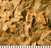
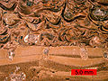 There have been a number of paleontological finds within the Carmel Formation. Among these have been bryozoa
ns, oysters, as well as dinosaur foot prints.
 Geologic Province:
Geologic formation
A formation or geological formation is the fundamental unit of lithostratigraphy. A formation consists of a certain number of rock strata that have a comparable lithology, facies or other similar properties...
in the San Rafael Group
San Rafael Group
The San Rafael Group is a geologic group of formations that is spread across the U.S. states of New Mexico, Arizona, Utah and Colorado. Part of the Colorado Plateau, this group of formations was laid down in the Middle Jurassic during the Bajocian, Bathonian and Callovian stages. Asterisks ...
that is spread across the U.S. state
U.S. state
A U.S. state is any one of the 50 federated states of the United States of America that share sovereignty with the federal government. Because of this shared sovereignty, an American is a citizen both of the federal entity and of his or her state of domicile. Four states use the official title of...
s of Wyoming
Wyoming
Wyoming is a state in the mountain region of the Western United States. The western two thirds of the state is covered mostly with the mountain ranges and rangelands in the foothills of the Eastern Rocky Mountains, while the eastern third of the state is high elevation prairie known as the High...
, Utah
Utah
Utah is a state in the Western United States. It was the 45th state to join the Union, on January 4, 1896. Approximately 80% of Utah's 2,763,885 people live along the Wasatch Front, centering on Salt Lake City. This leaves vast expanses of the state nearly uninhabited, making the population the...
, Colorado
Colorado
Colorado is a U.S. state that encompasses much of the Rocky Mountains as well as the northeastern portion of the Colorado Plateau and the western edge of the Great Plains...
, north east Arizona
Arizona
Arizona ; is a state located in the southwestern region of the United States. It is also part of the western United States and the mountain west. The capital and largest city is Phoenix...
and New Mexico
New Mexico
New Mexico is a state located in the southwest and western regions of the United States. New Mexico is also usually considered one of the Mountain States. With a population density of 16 per square mile, New Mexico is the sixth-most sparsely inhabited U.S...
. Part of the Colorado Plateau
Colorado Plateau
The Colorado Plateau, also called the Colorado Plateau Province, is a physiographic region of the Intermontane Plateaus, roughly centered on the Four Corners region of the southwestern United States. The province covers an area of 337,000 km2 within western Colorado, northwestern New Mexico,...
, this formation was laid down in the Middle Jurassic
Middle Jurassic
The Middle Jurassic is the second epoch of the Jurassic Period. It lasted from 176-161 million years ago. In European lithostratigraphy, rocks of this Middle Jurassic age are called the Dogger....
during the late Bajocian
Bajocian
In the geologic timescale, the Bajocian is an age or stage in the Middle Jurassic. It lasted from approximately 171.6 Ma to around 167.7 Ma . The Bajocian age succeeds the Aalenian age and precedes the Bathonian age....
, through the Bathonian
Bathonian
In the geologic timescale the Bathonian is an age or stage of the Middle Jurassic. It lasted from approximately 167.7 Ma to around 164.7 Ma...
and into the early Callovian
Callovian
In the geologic timescale, the Callovian is an age or stage in the Middle Jurassic, lasting between 164.7 ± 4.0 Ma and 161.2 ± 4.0 Ma. It is the last stage of the Middle Jurassic, following the Bathonian and preceding the Oxfordian....
stages.
Subunits
Members (alphabetical):- Co-op Creek Limestone Member (UT),
- Crystal Creek Member (UT),
- Homestake Limestone Member (UT*),
- Judd Hollow Member (AZ*,UT*) or Judd Hollow Tongue (AZ*,UT*),
- Kolob Limestone Member (UT), [name violates the 1983 North American Stratigraphic Code]
- Paria River Member (UT*),
- Wiggler Wash Member (UT*),
- Winsor Member (UT*).
(Asterisks mean the name is used by the U.S. Geological Survey).
History of investigation
Mount Carmel
Mount Carmel ; , Kármēlos; , Kurmul or جبل مار إلياس Jabal Mar Elyas 'Mount Saint Elias') is a coastal mountain range in northern Israel stretching from the Mediterranean Sea towards the southeast. Archaeologists have discovered ancient wine and oil presses at various locations on Mt. Carmel...
but did not give a type locality
Type locality (geology)
Type locality , also called type area or type locale, is the where a particular rock type, stratigraphic unit, fossil or mineral species is first identified....
. They noted it as a basal formation in the San Rafael Group (new) in San Rafael Swell
San Rafael Swell
The San Rafael Swell is a large geologic feature located in south-central Utah, USA about 30 miles west of Green River, Utah. The San Rafael Swell, approximately by , consists of a giant dome-shaped anticline of sandstone, shale, and limestone that was pushed up during the Paleocene Laramide...
, in Emery County, Utah
Emery County, Utah
Emery County is a county located in the U.S. state of Utah. As of 2000 the population was 10,860, and by 2009 had been estimated to decrease to 10,629. It was named for George W. Emery, governor of the Utah Territory in 1875...
. An overview along with a type locality and source of name was stated by Gregory and Moore in 1931. Mackin revised the formation's description and assigned the Homestake Limestone Member to it in 1954. Harshbarger and others created an overview in 1957. Its eastern areal limits were described by Wright and others in 1962. In 1963, western areal limits along with an overview were completed by Schultz and Wright. Another revision was done by Phoenix in 1963 who also added a Judd Hollow Tongue member. Isotopic dating was conducted by Marvin and others in 1965. The Kolob, Crystal Creek, Paria River, Winsor, and Wiggler Wash members were assiged by Thompson and Stokes in 1970. Areal limits were adjusted by O'Sullivan and Craig in 1973 and again in 1983 by Blakey and others. An overview was completed by Chapman in 1989. Hintze and others conducted isotopic dating and created an overview in 1994.
Paleontological Finds
Bryozoa
The Bryozoa, also known as Ectoprocta or commonly as moss animals, are a phylum of aquatic invertebrate animals. Typically about long, they are filter feeders that sieve food particles out of the water using a retractable lophophore, a "crown" of tentacles lined with cilia...
ns, oysters, as well as dinosaur foot prints.
Bryozoans
There have been a number of bryozoans found within the Carmel Formation. These finds include but are not limited to seven species of calcareous cyclostome bryozoans as well as a soft-bodied ctenosome bryozoan.Places found
- Black Mesa Basin*
- Capitol Reef National ParkCapitol Reef National ParkCapitol Reef National Park is a United States National Park, in south-central Utah. It is 100 miles long but fairly narrow. The park, established in 1971, preserves 378 mi² and is open all year, although May through September are the most popular months.Called "Wayne Wonderland" in the 1920s...
- Great BasinGreat BasinThe Great Basin is the largest area of contiguous endorheic watersheds in North America and is noted for its arid conditions and Basin and Range topography that varies from the North American low point at Badwater Basin to the highest point of the contiguous United States, less than away at the...
province* - Green River Basin*
- Paradox BasinParadox BasinThe Paradox Basin is an asymmetric foreland basin located mostly in southeast Utah and southwest Colorado, but extending into northeast Arizona and northwest New Mexico. The basin is a large elongate northwest to southeast oriented depression formed during the late Paleozoic Era...
* - Plateau sedimentary province*
- San Juan BasinSan Juan BasinThe San Juan Basin is a geologic structural basin in the Four Corners region of the Southwestern United States; its main portion covers around , encompassing much of northwestern New Mexico, southwest Colorado, and parts of Arizona and Utah....
- Uinta Basin*
- Uinta Uplift*
External links
- GEOLEX database entry for Carmel, USGS (viewed 20 March 2006)
- GEOLEX database: Summary of Citations for Carmel, USGS (viewed 20 March 2006)