
Paunsaugunt Plateau
Encyclopedia
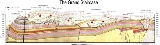
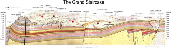
The Paunsaugunt Plateau is a dissected plateau
, rising to an elevation of 7000–9300 ft (2,133.6–2,834.6 ), in southwestern Utah
in the United States
. Located in northern Kane County
and southwestern Garfield County
, it is approximately 10 miles (16.1 km) wide, and extends southward from the Sevier Plateau approximately 25 miles (40.2 km), terminating in the Pink Cliffs
at the southern end.
It is drained by the East Fork Sevier River which flows northward on the plateau, to the meet the main branch (Sevier River
) which flows in a valley along the western side of the plateau. The plateau is highly dissected along the eastern flank, which is drained by the Escalante
and Paria Rivers
in the Colorado River watershed, and is protected as Bryce Canyon National Park
. A section of the Great Basin Divide
is along the plateau, and much of the plateau is part of Dixie National Forest
. The plateau receives approximately 200 inches (508 cm) of snow per year and experiences approximately 200 days of freeze-and-thaw cycles. Utah's Highway 12, an All-American Road, climbs to the top of the Paunsaugunt Plateau.
Geologically
the plateau was created approximately 10-20 million years ago by an uplift on the larger Colorado Plateau
. The uplifting caused the formation of joints along the side of the plateau. Subsequent erosive forces, especially along the eastern side in Bryce Canyon National Park, have resulted in the creation of strange rock formations called hoodoo
s which are the hallmark of the park.
Plateau
In geology and earth science, a plateau , also called a high plain or tableland, is an area of highland, usually consisting of relatively flat terrain. A highly eroded plateau is called a dissected plateau...
, rising to an elevation of 7000–9300 ft (2,133.6–2,834.6 ), in southwestern Utah
Utah
Utah is a state in the Western United States. It was the 45th state to join the Union, on January 4, 1896. Approximately 80% of Utah's 2,763,885 people live along the Wasatch Front, centering on Salt Lake City. This leaves vast expanses of the state nearly uninhabited, making the population the...
in the United States
United States
The United States of America is a federal constitutional republic comprising fifty states and a federal district...
. Located in northern Kane County
Kane County, Utah
As of the census of 2000, there were 6,046 people, 2,237 households, and 1,628 families residing in the county. The population density was 2 people per square mile . There were 3,767 housing units at an average density of 1 per square mile...
and southwestern Garfield County
Garfield County, Utah
Garfield County is a county located in the U.S. state of Utah. As of 2000 the population was 4,735. It was named for James A. Garfield, President of the United States in 1881. Its county seat and largest city is Panguitch.-Geography:...
, it is approximately 10 miles (16.1 km) wide, and extends southward from the Sevier Plateau approximately 25 miles (40.2 km), terminating in the Pink Cliffs
Pink Cliffs
The Pink Cliffs are a series of highly-dissected cliffs, approximately 35 mi long, along the southeast edge of the Paunsaugunt Plateau in southwestern Utah in the United States...
at the southern end.
It is drained by the East Fork Sevier River which flows northward on the plateau, to the meet the main branch (Sevier River
Sevier River
The Sevier River , extending , is the longest Utah river entirely in the state and drains an extended chain of mountain farming valleys to the intermittent Sevier Lake...
) which flows in a valley along the western side of the plateau. The plateau is highly dissected along the eastern flank, which is drained by the Escalante
Escalante River
right|Location of the Escalante River within UtahThe Escalante River is a tributary of the Colorado River. It is formed by the confluence of North and Birch Creeks near the town of Escalante in south-central Utah, and from there flows southeast for approximately before joining Lake Powell...
and Paria Rivers
Paria River
The Paria River is a tributary of the Colorado River, approximately long, in southern Utah and northern Arizona in the United States. It drains a rugged and arid region northwest of the Colorado, flowing through roadless slot canyons along part of its course....
in the Colorado River watershed, and is protected as Bryce Canyon National Park
Bryce Canyon National Park
Bryce Canyon National Park is a national park located in southwestern Utah in the United States. The major feature of the park is Bryce Canyon which, despite its name, is not a canyon but a giant natural amphitheater created by erosion along the eastern side of the Paunsaugunt Plateau...
. A section of the Great Basin Divide
Great Basin Divide
The Great Basin Divide is the western continental divide that separates the Great Basin from the Pacific Ocean watershed. The water divide is the perimeter of the largest set of contiguous endorheic watersheds of North America, including six entire USGS watershed subregions...
is along the plateau, and much of the plateau is part of Dixie National Forest
Dixie National Forest
Dixie National Forest is a United States National Forest in Utah with headquarters in Cedar City. It occupies almost two million acres and stretches for about 170 miles across southern Utah. The largest national forest in Utah, it straddles the divide between the Great Basin and the Colorado River...
. The plateau receives approximately 200 inches (508 cm) of snow per year and experiences approximately 200 days of freeze-and-thaw cycles. Utah's Highway 12, an All-American Road, climbs to the top of the Paunsaugunt Plateau.
Geologically
Geology
Geology is the science comprising the study of solid Earth, the rocks of which it is composed, and the processes by which it evolves. Geology gives insight into the history of the Earth, as it provides the primary evidence for plate tectonics, the evolutionary history of life, and past climates...
the plateau was created approximately 10-20 million years ago by an uplift on the larger Colorado Plateau
Colorado Plateau
The Colorado Plateau, also called the Colorado Plateau Province, is a physiographic region of the Intermontane Plateaus, roughly centered on the Four Corners region of the southwestern United States. The province covers an area of 337,000 km2 within western Colorado, northwestern New Mexico,...
. The uplifting caused the formation of joints along the side of the plateau. Subsequent erosive forces, especially along the eastern side in Bryce Canyon National Park, have resulted in the creation of strange rock formations called hoodoo
Hoodoo (geology)
A hoodoo is a tall, thin spire of rock that protrudes from the bottom of an arid drainage basin or badland. Hoodoos consist of relatively soft rock topped by harder, less easily eroded stone that protects each column from the elements...
s which are the hallmark of the park.
External links
- Geology of Bryce Canyon National Park from the National Park ServiceNational Park ServiceThe National Park Service is the U.S. federal agency that manages all national parks, many national monuments, and other conservation and historical properties with various title designations...
- Hoodoos of Bryce Canyon
- Brief description and view of Paunsaugunt Plateau
- Paunsaugunt OHV Trail