
Geography of Malaysia
Encyclopedia
The geography of Malaysia deals with the physical
and human geography
of Malaysia, a country located in Southeast Asia
. There are two distinct parts to this country being Peninsular Malaysia
to the west and East Malaysia
to the east. Peninsular Malaysia is located south of Thailand
, north of Singapore
and east of the Indonesia
n island of Sumatra
. East Malaysia is located on the island of Borneo
and shares borders with Brunei
and Indonesia
.
, Malaysia's climate is categorised as equatorial, being hot and humid throughout the year. The average rainfall is 250 centimetres (98 in) a year and the average temperature is 27 °C (80.6 °F). The climates of the Peninsula and the East differ, as the climate on the peninsula is directly affected by wind from the mainland, as opposed to the more maritime weather of the East. Malaysia is exposed to the El Nino effect, which reduces rainfall in the dry season. Climate change
is likely to have a significant effect on Malaysia, increasing sea level
s and rainfall, increasing flooding risks and leading to large droughts.
Malaysia faces two monsoon
winds seasons, the Southwest Monsoon from late May to September, and the Northeast Monsoon from November to March. The Northeast Monsoon brings in more rainfall compared to the Southwest Monsoon, originating in China
and the north Pacific. The southwest monsoon originates from the deserts of Australia
. March and October form transitions between the two monsoons.
Local climates are affected by the presence of mountain ranges throughout Malaysia, and climate can be divided into that of the highlands, the lowlands, and coastal regions. The coasts have a sunny climate, with temperatures ranging between 23 °C (73.4 °F) and 32 °C (89.6 °F), and rainfall ranging from 10 centimetres (4 in) to 30 centimetres (12 in) a month. The lowlands have a similar temperature, but follow a more distinctive rainfall pattern and show very high humidity levels. The highlands are cooler and wetter, and display a greater temperature variation. A large amount of cloud cover is present over the highlands, which have humidity levels that do not fall below 75%.
The highest temperature was recorded at Chuping
, Perlis
on 9 April 1998 at 40.1 °C (104.2 °F). The lowest temperature was recorded at Cameron Highlands
on 1 February 1978 at 7.8 °C (46 °F). The highest rainfall recorded in a day was 608 mm (23.9 in) in Kota Bharu
, Kelantan
on 6 January 1967. The highest rainfall recorded in a year was 5687 mm (223.9 in) at Sandakan
, Sabah
in 2006. Meanwhile, the lowest rainfall recorded in a year was 1151 mm (45.3 in) at Tawau
, Sabah
in 1997. The wettest place in Malaysia is Kuching, Sarawak
with an average rainfall of 4128 mm (162.5 in) with 247 days of rain a year. The driest place in Malaysia is in Chuping
, Perlis
with average rainfall of only 1746 mm (68.7 in) a year.
, and is tectonically inactive. The oldest rocks in the country date from 540million years ago, and are mostly sedimentary. The most common form of rock is limestone
, formed during the Paleozoic era. Limestone laid down in East Malaysia during the Tertiary period has since eroded, and such erosion forms basins of sedimentary rocks rich in oil
and natural gas
. The mountain ranges in Malaysia were formed through orogenesis beginning in the Mesozoic era.
 The total land area of Malaysia is 329847 square kilometres (127,354.6 sq mi), the 67th largest country in the world in terms of area. It is the only country to contain land on both mainland Asia
and the Malay archipelago
. Peninsular Malaysia makes up 132090 square kilometres (51,000.2 sq mi), or 39.7%, while East Malaysia covers 198847 square kilometres (76,775.3 sq mi), or 60.3% of the total land of the country. From the total land area, 1200 square kilometres (463.3 sq mi) or 0.37% is made up of water such as lake
s, river
s, or other internal waters
. Malaysia has a total coastline of 4675 kilometres (2,905 mi), whereby Peninsular Malaysia has 2068 kilometres (1,285 mi), while East Malaysia has 2607 kilometres (1,620 mi) of coastline. Malaysia has the 29th longest coastline in the world. The two distinct parts of Malaysia, separated from each other by the South China Sea
, share a largely similar landscape in that both West
(Peninsula) and East Malaysia
feature coastal plains rising to hills and mountains.
Peninsula Malaysia covers the southern half of the Malay Peninsula
, and extends 740 kilometres (460 mi) from north to south, and its maximum width is 322 kilometres (200 mi). It is very mountainous, with more than half of it over 150 metres (492 ft) above sea level
. About half of Peninsular Malaysia is covered by granite
and other igneous rock
s, a third more is covered by stratified rocks older than the granite, and the remainder is covered by alluvium
. Harbours are only available on the peninsula's western side, and the most fertile land occurs when river valleys flow out to the sea. The coastal plains bordering the straits of Malacca are the most densely populated areas of Malaysia, and contains Malaysia's capital, Kuala Lumpur
.
East Malaysia, on the island of Borneo
, has a coastline of 2607 kilometres (1,620 mi). It is divided between coastal regions, hills and valleys, and a mountainous interior. There are only two major cities, Kuching
and Kota Kinabalu
. Much of southern Sarawak is coastal lowlands, which shifts to a series of plateaus going north, ending in the mountainous regions of Sabah.
in Sabah, which divides the state in half. This range houses Mount Kinabalu
, the highest mountain in the country, as well as Mount Tambuyukon
, the third highest in the country. Mount Kinabalu, at 4095.2 metres (13,435.7 ft), is the tallest mountain in Malaysia and is protected as Kinabalu National Park
, a UNESCO World Heritage Site
. Mountain ranges in the East tend to follow north-south or northeast-southwest paths, and the highest ranges form the border between Malaysia and Indonesia. The mountains contain many jagged limestone peaks. The Trus Madi Range
, also in Sabah, houses Mount Trus Madi
, the second highest peak in Malaysia. Bombalai Hill in Sabah is the only active volcano
in Malaysia.
Peninsula Malaysia contains numerous mountain ranges running parallel from north to south along the peninsula. The main mountain range is the Titiwangsa Mountains
, which divides the peninsula between its east and west coasts. It houses Mount Korbu
, the second highest peak in the Peninsular. These mountains are heavily forested, and mainly composed of granite
. The range is the origin of some of Peninsula Malaysia's river systems. To the east of this range is the Bintang Range. The highest peak in the Peninsular is Mount Tahan
, located on the Tahan Range.
. Approximately 58.2% of Malaysian land is covered by forest. A large amount of lowland forest present below an altitude of 760 metres (2,493 ft). East Malaysia, like most of Borneo, was formerly covered with Borneo lowland rain forests with over 2000 tree species. However, much of it has been cleared, due to the increase in logging since the 1960s and the increase of shifting cultivation. Over 80% of Sarawak's forests have been felled, and the logging throughout East Malaysia has polluted waterways, increased erosion, and damaged agriculture. Some state governments have now taken measures to halt the degradation of the rainforst.
Malaysia's rainforest's are made of a variety of types, mainly dipterocarp
, swamps, and mangrove
s. The majority of the forest is dipterocarp
forests. Dipterocarps species are centred in Malaysia. There are over 1425 square kilometres (550.2 sq mi) of mangroves in Malaysia. Some areas are designated as forest reserves, state parks, or national parks. The management of these reserves as under control of the Department of Wildlife and National Park, the Forest Department of Sarawak, the Sabah Forestry Department, Sabah Foundation, and Sabah Parks
. As of 2000, there are two World Heritage Site
s under the natural category – Kinabalu National Park
and Gunung Mulu National Park
.
landscape caused by water eroding limestone. The Mulu Caves in East Malaysia are the largest caves in the world. They are located between the Penambo range and Brunei
, and form a major tourist attraction. At 700 metres (2,297 ft) long and 70 metres (230 ft) high the Sarawak Chamber
is the largest cave chamber in the world. Other famous caves are the 1.6 kilometre (0.994196378639691 mi) Deer Cave
and Lang's Cave.
, which has an area of 92 square kilometres (35.5 sq mi). It is followed by Banggi Island
in Sabah, followed by Betruit Island in Sarawak, Langkawi
in Kedah, and Penang Island
in Penang. The largest island shared with another country is Borneo
, followed by Sebatik Island
. In addition, Malaysia lies within the world's coral reef
distribution. The reefs can be usually found around islands such as Sipadan Island, Swallow Reef
, and Redang Island
. Sipadan Island, an underwater mountain, is Malaysia's only oceanic island.
in Sarawak. Tanjung Piai
on the southern tip of Johor
is the southermost point in Peninsular, and thus of the whole of continental Eurasia
. The easternmost point is found on the tip of Dent Peninsular in Lahad Datu
district in Sabah. The northernmost point is found on the northern tip of Banggi Island. The westernmost point is found on the western tip of Pulau Langkawi in Kedah.
 Between Peninsular Malaysia and East Malaysia is the South China Sea
, the largest body of water around Malaysia. Facing the western coast of Peninsular Malaysia there is the Straits of Malacca towards the south, and the Andaman Sea
towards the north. The Strait of Malacca
, lying between Sumatra
and Peninsular Malaysia, is arguably the most important shipping lane in the world. These seas are marginal sea
s of the Indian Ocean
. Off the east coast of Peninsular Malaysia is the South China Sea, while a small part in the north lies within the Gulf of Thailand
. These form part of the marginal seas of the Pacific Ocean
. The Straits of Johor
off the south of Peninsular acts as a maritime border of Malaysia and Singapore
. In East Malaysia, the western coasts of Sabah and Sarawak faces the South China Sea. The northeast coast of Sabah faces the Sulu Sea
, while the southeast coast of Sabah faces the Celebes Sea
.
Malaysia claims 12 nm (22 kilometres (14 mi)) as its territorial waters
, which extend into the Coral Triangle
. It also claims 200 nm (370 kilometres (230 mi)) of exclusive economic zone
. In addition, Malaysia claims 200 metres (656 ft) in the depth of the continental shelf
or to the depth of exploration in within the area below the South China Sea known as Sundaland
. The territorial claim for the Straits of Malacca is shared between Malaysia and Indonesia in accordance to a treaty signed in 1970 known as the Treaty Between the Republic of Indonesia and Malaysia on Determination of boundary Lines of Territorial Waters of the two Nations at the Strait of Malacca.
in Pahang is one of the largest lakes in Malaysia, and one of the only two natural lakes in Malaysia with Tasik Chini. Pedu Lake
is a 12 kilometres (7 mi) long lake located 5 kilometres (3 mi) from the Malaysian-Thai border and Kenyir Lake
is the largest artificial lake in Southeast Asia.
in Sarawak with a length of 760 kilometres (472 mi). The second longest is the Kinabatangan river
in Sabah with a length of 560 kilometres (348 mi). The longest river in the Peninsular Malaysia is Pahang River
with a length of 435 kilometres (270 mi).
, the largest flower in the world. The clearing of the Borneo lowland rain forests has been cleared causing wildlife to retreat into the upland rain forests
inland.
has resulted in loss of RM
1.5 billion and 18 lives in addition displacing 110,000 people temporarily.
, Australian Plate and Eurasian Plate
in the west of Peninsular Malaysia and Philippine Sea Plate and Eurasian Plate
in the East of Malaysia. Tremors, mostly non-lethal can be felt in Malaysia, caused by earthquakes in Sumatra
islands of Indonesia
and the Philippines
.
Impacts of seismic activity on building in Malaysia has heighten interest since the 2004 Indian Ocean earthquake
. Although Malaysia is seismically stable, areas of concern are the west coast of Peninsular Malaysia such as Penang
and Kedah
and also the eastern state of Sabah
.
as well as various other related products, most of which are found off the coasts of Terengganu
, Sabah
, and Sarawak
.
Natural resources:tin, petroleum, timber, copper, iron, ore, natural gas, bauxite
Malaysia was the largest exporter of tin
until the industry wide collapse in 1980s. Tin deposit are found in Selangor
, Kinta
valley in Perak
, Pahang
and Johor
. There are significant deposit of gold in Pahang
towns of Raub
and Kuala Lipis
and also Kelantan
's district of Gua Musang
.
Coal
is mostly concerated in Sarawak
town of Kapit
, Mukah
and Silantek.
can be found in the vast jungles in Malaysia, especially in East Malaysia. Malaysia total exports for timber and other timber products amounted to MYR
23.4 billion in 2007.
plantations, rubber
plantations, and paddy fields. Malaysia is the largest exporter of palm oil in the world producing 15.8 million tonnes of crude palm oil in 2007. Malaysia is also one of the largest producers and exporters of rubber and other rubber products.
In 2001 the percentage arable land in Malaysia is 5.5%. Croplands consists of 17.6%, and pasture 0.9%. Forests covers 58% while other land uses consists of 17%. In 1998, irrigated land covers 2,941 km².
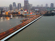
s, while the rest live in rural
areas. The largest city is Kuala Lumpur
with a population of 1.89 million people in the city, and about 7 million in the metropolitan area known as Klang Valley
. Other major cities include Georgetown, Johor Bahru
, Ipoh
, Kuching
, and Kota Kinabalu
.
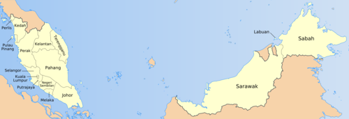
Malaysia is divided into thirteen states
and three Federal Territories. Eleven states and two Federal Territories are found in Peninsular Malaysia. While two states and one Federal Territory are found in East Malaysia. The states are further divided into administrative districts
. In Sabah and Sarawak, they are first divided into divisions
, then further divided into districts. There are separate subdivisions for electoral districts for polling purposes.
International border
s between Malaysia and Indonesia
, Thailand
, Singapore
and Brunei
are defined mostly by geological features such as the Perlis River
and Golok River between Malaysia and Thailand; Straits of Johor
between Malaysia and Singapore; and Pagalayan Canal between Malaysia and Brunei. However, borders that extends to the seas are defined by agreements such as Straits Settlement and Johore Territorial Waters Agreement of 1927
which defines Malaysia and Singapore water borders.
Malaysia's land borders are well established. The border with Thailand was established in 1909 when Siam ceded Kedah
, Kelantan
, Perlis
and Terengganu
to the British. Maritime border disputes between Brunei
and Malaysia and a Bruneian claim on Limbang, Sarawak
were resolved in an exchange of letters between the two countries on 16 March 2009 after 20 years of negotiations. Malaysia and Indonesia
have some overlapping maritime claims, notably in the area around Sabah
. An ongoing series of meetings to resolve these claims has produced 16 border agreements (to September 2010). Malaysia and Singapore
also have disputes concerning some maritime borders. The Philippines
has a dormant claim to the Malaysian state of Sabah
. Malaysia is also involved in a complex dispute, involving Vietnam
, Brunei, the People's Republic of China
, the Philippines, and the Republic of China
(Taiwan), concerning the Spratly Islands
in the South China Sea
.
Physical geography
Physical geography is one of the two major subfields of geography. Physical geography is that branch of natural science which deals with the study of processes and patterns in the natural environment like the atmosphere, biosphere and geosphere, as opposed to the cultural or built environment, the...
and human geography
Human geography
Human geography is one of the two major sub-fields of the discipline of geography. Human geography is the study of the world, its people, communities, and cultures. Human geography differs from physical geography mainly in that it has a greater focus on studying human activities and is more...
of Malaysia, a country located in Southeast Asia
Southeast Asia
Southeast Asia, South-East Asia, South East Asia or Southeastern Asia is a subregion of Asia, consisting of the countries that are geographically south of China, east of India, west of New Guinea and north of Australia. The region lies on the intersection of geological plates, with heavy seismic...
. There are two distinct parts to this country being Peninsular Malaysia
Peninsular Malaysia
Peninsular Malaysia , also known as West Malaysia , is the part of Malaysia which lies on the Malay Peninsula. Its area is . It shares a land border with Thailand in the north. To the south is the island of Singapore. Across the Strait of Malacca to the west lies the island of Sumatra...
to the west and East Malaysia
East Malaysia
East Malaysia, also known as Malaysian Borneo, is the part of Malaysia located on the island of Borneo. It consists of the Malaysian states of Sabah and Sarawak, and the Federal Territory of Labuan. It lies to the east from Peninsular Malaysia , which is located on the Malay Peninsula. The two are...
to the east. Peninsular Malaysia is located south of Thailand
Thailand
Thailand , officially the Kingdom of Thailand , formerly known as Siam , is a country located at the centre of the Indochina peninsula and Southeast Asia. It is bordered to the north by Burma and Laos, to the east by Laos and Cambodia, to the south by the Gulf of Thailand and Malaysia, and to the...
, north of Singapore
Singapore
Singapore , officially the Republic of Singapore, is a Southeast Asian city-state off the southern tip of the Malay Peninsula, north of the equator. An island country made up of 63 islands, it is separated from Malaysia by the Straits of Johor to its north and from Indonesia's Riau Islands by the...
and east of the Indonesia
Indonesia
Indonesia , officially the Republic of Indonesia , is a country in Southeast Asia and Oceania. Indonesia is an archipelago comprising approximately 13,000 islands. It has 33 provinces with over 238 million people, and is the world's fourth most populous country. Indonesia is a republic, with an...
n island of Sumatra
Sumatra
Sumatra is an island in western Indonesia, westernmost of the Sunda Islands. It is the largest island entirely in Indonesia , and the sixth largest island in the world at 473,481 km2 with a population of 50,365,538...
. East Malaysia is located on the island of Borneo
Borneo
Borneo is the third largest island in the world and is located north of Java Island, Indonesia, at the geographic centre of Maritime Southeast Asia....
and shares borders with Brunei
Brunei
Brunei , officially the State of Brunei Darussalam or the Nation of Brunei, the Abode of Peace , is a sovereign state located on the north coast of the island of Borneo, in Southeast Asia...
and Indonesia
Indonesia
Indonesia , officially the Republic of Indonesia , is a country in Southeast Asia and Oceania. Indonesia is an archipelago comprising approximately 13,000 islands. It has 33 provinces with over 238 million people, and is the world's fourth most populous country. Indonesia is a republic, with an...
.
Climate
Located near the equatorEquator
An equator is the intersection of a sphere's surface with the plane perpendicular to the sphere's axis of rotation and containing the sphere's center of mass....
, Malaysia's climate is categorised as equatorial, being hot and humid throughout the year. The average rainfall is 250 centimetres (98 in) a year and the average temperature is 27 °C (80.6 °F). The climates of the Peninsula and the East differ, as the climate on the peninsula is directly affected by wind from the mainland, as opposed to the more maritime weather of the East. Malaysia is exposed to the El Nino effect, which reduces rainfall in the dry season. Climate change
Climate change
Climate change is a significant and lasting change in the statistical distribution of weather patterns over periods ranging from decades to millions of years. It may be a change in average weather conditions or the distribution of events around that average...
is likely to have a significant effect on Malaysia, increasing sea level
Sea level
Mean sea level is a measure of the average height of the ocean's surface ; used as a standard in reckoning land elevation...
s and rainfall, increasing flooding risks and leading to large droughts.
Malaysia faces two monsoon
Monsoon
Monsoon is traditionally defined as a seasonal reversing wind accompanied by corresponding changes in precipitation, but is now used to describe seasonal changes in atmospheric circulation and precipitation associated with the asymmetric heating of land and sea...
winds seasons, the Southwest Monsoon from late May to September, and the Northeast Monsoon from November to March. The Northeast Monsoon brings in more rainfall compared to the Southwest Monsoon, originating in China
China
Chinese civilization may refer to:* China for more general discussion of the country.* Chinese culture* Greater China, the transnational community of ethnic Chinese.* History of China* Sinosphere, the area historically affected by Chinese culture...
and the north Pacific. The southwest monsoon originates from the deserts of Australia
Australia
Australia , officially the Commonwealth of Australia, is a country in the Southern Hemisphere comprising the mainland of the Australian continent, the island of Tasmania, and numerous smaller islands in the Indian and Pacific Oceans. It is the world's sixth-largest country by total area...
. March and October form transitions between the two monsoons.
Local climates are affected by the presence of mountain ranges throughout Malaysia, and climate can be divided into that of the highlands, the lowlands, and coastal regions. The coasts have a sunny climate, with temperatures ranging between 23 °C (73.4 °F) and 32 °C (89.6 °F), and rainfall ranging from 10 centimetres (4 in) to 30 centimetres (12 in) a month. The lowlands have a similar temperature, but follow a more distinctive rainfall pattern and show very high humidity levels. The highlands are cooler and wetter, and display a greater temperature variation. A large amount of cloud cover is present over the highlands, which have humidity levels that do not fall below 75%.
The highest temperature was recorded at Chuping
Chuping
Chuping is a small town in Perlis, Malaysia. It is located to the northeast of Kangar, the state capital. The town has 22,000 hectares of plantations, which consist of rubber estates and the largest sugar cane plantation in Malaysia....
, Perlis
Perlis
Perlis is the smallest state in Malaysia. It lies at the northern part of the west coast of Peninsular Malaysia and has Satun and Songkhla Provinces of Thailand on its northern border. It is bordered by the state of Kedah to the south...
on 9 April 1998 at 40.1 °C (104.2 °F). The lowest temperature was recorded at Cameron Highlands
Cameron Highlands
The Cameron Highlands is one of Malaysia’s most extensive hill stations. It covers an area of .To the north, its boundary touches that of Kelantan; to the west, it shares part of its border with Perak....
on 1 February 1978 at 7.8 °C (46 °F). The highest rainfall recorded in a day was 608 mm (23.9 in) in Kota Bharu
Kota Bharu
Kota Bharu is a city in Malaysia, is the state capital and Royal City of Kelantan. It is also the name of the territory in which Kota Bharu City is situated. The name means 'new city' or 'new castle/fort' in Malay. Kota Bharu is situated in the northeastern part of Peninsular Malaysia, and lies...
, Kelantan
Kelantan
Kelantan is a state of Malaysia. The capital and royal seat is Kota Bharu. The Arabic honorific of the state is Darul Naim, ....
on 6 January 1967. The highest rainfall recorded in a year was 5687 mm (223.9 in) at Sandakan
Sandakan
Sandakan is the second-largest city in Sabah, East Malaysia, on the north-eastern coast of Borneo. It is located on the east coast of the island and it is the administrative centre of Sandakan Division and was the former capital of British North Borneo...
, Sabah
Sabah
Sabah is one of 13 member states of Malaysia. It is located on the northern portion of the island of Borneo. It is the second largest state in the country after Sarawak, which it borders on its southwest. It also shares a border with the province of East Kalimantan of Indonesia in the south...
in 2006. Meanwhile, the lowest rainfall recorded in a year was 1151 mm (45.3 in) at Tawau
Tawau
Tawau is the administrative center of Tawau Division, Malaysia and the third largest town of Sabah after Kota Kinabalu and Sandakan.-Geography:...
, Sabah
Sabah
Sabah is one of 13 member states of Malaysia. It is located on the northern portion of the island of Borneo. It is the second largest state in the country after Sarawak, which it borders on its southwest. It also shares a border with the province of East Kalimantan of Indonesia in the south...
in 1997. The wettest place in Malaysia is Kuching, Sarawak
Sarawak
Sarawak is one of two Malaysian states on the island of Borneo. Known as Bumi Kenyalang , Sarawak is situated on the north-west of the island. It is the largest state in Malaysia followed by Sabah, the second largest state located to the North- East.The administrative capital is Kuching, which...
with an average rainfall of 4128 mm (162.5 in) with 247 days of rain a year. The driest place in Malaysia is in Chuping
Chuping
Chuping is a small town in Perlis, Malaysia. It is located to the northeast of Kangar, the state capital. The town has 22,000 hectares of plantations, which consist of rubber estates and the largest sugar cane plantation in Malaysia....
, Perlis
Perlis
Perlis is the smallest state in Malaysia. It lies at the northern part of the west coast of Peninsular Malaysia and has Satun and Songkhla Provinces of Thailand on its northern border. It is bordered by the state of Kedah to the south...
with average rainfall of only 1746 mm (68.7 in) a year.
Geology
Malaysia is located on the Sunda shelfSunda Shelf
Geologically, the Sunda Shelf is a south east extension of the continental shelf of Southeast Asia. Major landmasses on the shelf include the Malay Peninsula, Sumatra, Borneo, Java, Madura, Bali and their surrounding smaller islands. It covers an area of approximately 1.85 million km2...
, and is tectonically inactive. The oldest rocks in the country date from 540million years ago, and are mostly sedimentary. The most common form of rock is limestone
Limestone
Limestone is a sedimentary rock composed largely of the minerals calcite and aragonite, which are different crystal forms of calcium carbonate . Many limestones are composed from skeletal fragments of marine organisms such as coral or foraminifera....
, formed during the Paleozoic era. Limestone laid down in East Malaysia during the Tertiary period has since eroded, and such erosion forms basins of sedimentary rocks rich in oil
Oil
An oil is any substance that is liquid at ambient temperatures and does not mix with water but may mix with other oils and organic solvents. This general definition includes vegetable oils, volatile essential oils, petrochemical oils, and synthetic oils....
and natural gas
Natural gas
Natural gas is a naturally occurring gas mixture consisting primarily of methane, typically with 0–20% higher hydrocarbons . It is found associated with other hydrocarbon fuel, in coal beds, as methane clathrates, and is an important fuel source and a major feedstock for fertilizers.Most natural...
. The mountain ranges in Malaysia were formed through orogenesis beginning in the Mesozoic era.
Land
Asia
Asia is the world's largest and most populous continent, located primarily in the eastern and northern hemispheres. It covers 8.7% of the Earth's total surface area and with approximately 3.879 billion people, it hosts 60% of the world's current human population...
and the Malay archipelago
Malay Archipelago
The Malay Archipelago refers to the archipelago between mainland Southeastern Asia and Australia. The name was derived from the anachronistic concept of a Malay race....
. Peninsular Malaysia makes up 132090 square kilometres (51,000.2 sq mi), or 39.7%, while East Malaysia covers 198847 square kilometres (76,775.3 sq mi), or 60.3% of the total land of the country. From the total land area, 1200 square kilometres (463.3 sq mi) or 0.37% is made up of water such as lake
Lake
A lake is a body of relatively still fresh or salt water of considerable size, localized in a basin, that is surrounded by land. Lakes are inland and not part of the ocean and therefore are distinct from lagoons, and are larger and deeper than ponds. Lakes can be contrasted with rivers or streams,...
s, river
River
A river is a natural watercourse, usually freshwater, flowing towards an ocean, a lake, a sea, or another river. In a few cases, a river simply flows into the ground or dries up completely before reaching another body of water. Small rivers may also be called by several other names, including...
s, or other internal waters
Internal waters
A nation's internal waters covers all water and waterways on the landward side of the baseline from which a nation's territorial waters is defined. It includes waterways such as rivers and canals, and sometimes the water within small bays. According to the United Nations Convention on the Law of...
. Malaysia has a total coastline of 4675 kilometres (2,905 mi), whereby Peninsular Malaysia has 2068 kilometres (1,285 mi), while East Malaysia has 2607 kilometres (1,620 mi) of coastline. Malaysia has the 29th longest coastline in the world. The two distinct parts of Malaysia, separated from each other by the South China Sea
South China Sea
The South China Sea is a marginal sea that is part of the Pacific Ocean, encompassing an area from the Singapore and Malacca Straits to the Strait of Taiwan of around...
, share a largely similar landscape in that both West
Peninsular Malaysia
Peninsular Malaysia , also known as West Malaysia , is the part of Malaysia which lies on the Malay Peninsula. Its area is . It shares a land border with Thailand in the north. To the south is the island of Singapore. Across the Strait of Malacca to the west lies the island of Sumatra...
(Peninsula) and East Malaysia
East Malaysia
East Malaysia, also known as Malaysian Borneo, is the part of Malaysia located on the island of Borneo. It consists of the Malaysian states of Sabah and Sarawak, and the Federal Territory of Labuan. It lies to the east from Peninsular Malaysia , which is located on the Malay Peninsula. The two are...
feature coastal plains rising to hills and mountains.
Peninsula Malaysia covers the southern half of the Malay Peninsula
Malay Peninsula
The Malay Peninsula or Thai-Malay Peninsula is a peninsula in Southeast Asia. The land mass runs approximately north-south and, at its terminus, is the southern-most point of the Asian mainland...
, and extends 740 kilometres (460 mi) from north to south, and its maximum width is 322 kilometres (200 mi). It is very mountainous, with more than half of it over 150 metres (492 ft) above sea level
Sea level
Mean sea level is a measure of the average height of the ocean's surface ; used as a standard in reckoning land elevation...
. About half of Peninsular Malaysia is covered by granite
Granite
Granite is a common and widely occurring type of intrusive, felsic, igneous rock. Granite usually has a medium- to coarse-grained texture. Occasionally some individual crystals are larger than the groundmass, in which case the texture is known as porphyritic. A granitic rock with a porphyritic...
and other igneous rock
Igneous rock
Igneous rock is one of the three main rock types, the others being sedimentary and metamorphic rock. Igneous rock is formed through the cooling and solidification of magma or lava...
s, a third more is covered by stratified rocks older than the granite, and the remainder is covered by alluvium
Alluvium
Alluvium is loose, unconsolidated soil or sediments, eroded, deposited, and reshaped by water in some form in a non-marine setting. Alluvium is typically made up of a variety of materials, including fine particles of silt and clay and larger particles of sand and gravel...
. Harbours are only available on the peninsula's western side, and the most fertile land occurs when river valleys flow out to the sea. The coastal plains bordering the straits of Malacca are the most densely populated areas of Malaysia, and contains Malaysia's capital, Kuala Lumpur
Kuala Lumpur
Kuala Lumpur is the capital and the second largest city in Malaysia by population. The city proper, making up an area of , has a population of 1.4 million as of 2010. Greater Kuala Lumpur, also known as the Klang Valley, is an urban agglomeration of 7.2 million...
.
East Malaysia, on the island of Borneo
Borneo
Borneo is the third largest island in the world and is located north of Java Island, Indonesia, at the geographic centre of Maritime Southeast Asia....
, has a coastline of 2607 kilometres (1,620 mi). It is divided between coastal regions, hills and valleys, and a mountainous interior. There are only two major cities, Kuching
Kuching
Kuching , officially the City of Kuching, and formerly the City of Sarawak, is the capital and most populous city of the East Malaysian state of Sarawak. It is the largest city on the island of Borneo, and the fourth largest city in Malaysia....
and Kota Kinabalu
Kota Kinabalu
Kota Kinabalu , formerly known as Jesselton, is the capital of Sabah state in East Malaysia. It is also the capital of the West Coast Division of Sabah. The city is located on the northwest coast of Borneo facing the South China Sea. The Tunku Abdul Rahman National Park lies on one side and Mount...
. Much of southern Sarawak is coastal lowlands, which shifts to a series of plateaus going north, ending in the mountainous regions of Sabah.
Mountain ranges
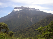
The highest mountain range in Malaysia is the Crocker RangeCrocker Range
Crocker Range , is a mountain range on the island of Borneo. Politically, it is within the boundary of the Malaysian state of Sabah, located in the northern half of Borneo. The mountain range separates the east coast and west coast of Sabah. At an average height of 1800m, it is the highest mountain...
in Sabah, which divides the state in half. This range houses Mount Kinabalu
Mount Kinabalu
Mount Kinabalu is a prominent mountain on the island of Borneo in Southeast Asia. It is located in the East Malaysian state of Sabah and is protected as Kinabalu National Park, a World Heritage Site. Kinabalu is the tallest peak in Borneo's Crocker Range and is the tallest mountain in the Malay...
, the highest mountain in the country, as well as Mount Tambuyukon
Mount Tambuyukon
Mount Tambuyukon or Tamboyukon is Malaysia's third highest mountain at 2,579 m . It lies close to the famous Mount Kinabalu. The mountain supports a wide range of unique flora and fauna, including a number of pitcher plant species of the genus Nepenthes....
, the third highest in the country. Mount Kinabalu, at 4095.2 metres (13,435.7 ft), is the tallest mountain in Malaysia and is protected as Kinabalu National Park
Kinabalu National Park
Kinabalu National Park or Taman Negara Kinabalu in Malay, established as one of the first national parks of Malaysia in 1964, is Malaysia's first World Heritage Site designated by UNESCO in December 2000 for its "outstanding universal values" and the role as one of the most important biological...
, a UNESCO World Heritage Site
World Heritage Site
A UNESCO World Heritage Site is a place that is listed by the UNESCO as of special cultural or physical significance...
. Mountain ranges in the East tend to follow north-south or northeast-southwest paths, and the highest ranges form the border between Malaysia and Indonesia. The mountains contain many jagged limestone peaks. The Trus Madi Range
Trus Madi Range
The Trus Madi Range is a range of mountains in Sabah, Borneo. It includes the state's second highest peak, Mount Trus Madi, after which it is named. The Trus Madi Range is a part of the Western Hill Ranges....
, also in Sabah, houses Mount Trus Madi
Mount Trus Madi
Mount Trus Madi or Trusmadi is Malaysia's second highest mountain at . It lies in the state of Sabah, close to Mount Kinabalu. The mountain supports a wide range of unique flora and fauna, perhaps most notably Nepenthes macrophylla, a species of pitcher plant.The natural hybrid Nepenthes ×...
, the second highest peak in Malaysia. Bombalai Hill in Sabah is the only active volcano
Volcano
2. Bedrock3. Conduit 4. Base5. Sill6. Dike7. Layers of ash emitted by the volcano8. Flank| 9. Layers of lava emitted by the volcano10. Throat11. Parasitic cone12. Lava flow13. Vent14. Crater15...
in Malaysia.
Peninsula Malaysia contains numerous mountain ranges running parallel from north to south along the peninsula. The main mountain range is the Titiwangsa Mountains
Titiwangsa Mountains
The Titiwangsa Mountains are the main mountain range that forms the backbone of the Malay Peninsula.-Geology:...
, which divides the peninsula between its east and west coasts. It houses Mount Korbu
Mount Korbu
Mount Korbu is a mountain in Perak, Malaysia. It is the highest peak of the Titiwangsa Mountains, the southernmost section of the Tenasserim Hills.Mt. Korbu is also the second highest mountain in Peninsular Malaysia, standing at 2,183 metres...
, the second highest peak in the Peninsular. These mountains are heavily forested, and mainly composed of granite
Granite
Granite is a common and widely occurring type of intrusive, felsic, igneous rock. Granite usually has a medium- to coarse-grained texture. Occasionally some individual crystals are larger than the groundmass, in which case the texture is known as porphyritic. A granitic rock with a porphyritic...
. The range is the origin of some of Peninsula Malaysia's river systems. To the east of this range is the Bintang Range. The highest peak in the Peninsular is Mount Tahan
Mount Tahan
Mount Tahan , at 2,187 m, is the highest point in Peninsular Malaysia. It is located within the Taman Negara national forest, in the state of Pahang. The mountain is part of the Tahan Range and popular to local climbers....
, located on the Tahan Range.
Forests
Malaysian forests can be categorised as tropical rainforestTropical rainforest
A tropical rainforest is an ecosystem type that occurs roughly within the latitudes 28 degrees north or south of the equator . This ecosystem experiences high average temperatures and a significant amount of rainfall...
. Approximately 58.2% of Malaysian land is covered by forest. A large amount of lowland forest present below an altitude of 760 metres (2,493 ft). East Malaysia, like most of Borneo, was formerly covered with Borneo lowland rain forests with over 2000 tree species. However, much of it has been cleared, due to the increase in logging since the 1960s and the increase of shifting cultivation. Over 80% of Sarawak's forests have been felled, and the logging throughout East Malaysia has polluted waterways, increased erosion, and damaged agriculture. Some state governments have now taken measures to halt the degradation of the rainforst.
Malaysia's rainforest's are made of a variety of types, mainly dipterocarp
Dipterocarpaceae
Dipterocarpaceae is a family of 17 genera and approximately 500 species of mainly tropical lowland rainforest trees. The family name, from the type genus Dipterocarpus, is derived from Greek and refers to the two-winged fruit...
, swamps, and mangrove
Mangrove
Mangroves are various kinds of trees up to medium height and shrubs that grow in saline coastal sediment habitats in the tropics and subtropics – mainly between latitudes N and S...
s. The majority of the forest is dipterocarp
Dipterocarpaceae
Dipterocarpaceae is a family of 17 genera and approximately 500 species of mainly tropical lowland rainforest trees. The family name, from the type genus Dipterocarpus, is derived from Greek and refers to the two-winged fruit...
forests. Dipterocarps species are centred in Malaysia. There are over 1425 square kilometres (550.2 sq mi) of mangroves in Malaysia. Some areas are designated as forest reserves, state parks, or national parks. The management of these reserves as under control of the Department of Wildlife and National Park, the Forest Department of Sarawak, the Sabah Forestry Department, Sabah Foundation, and Sabah Parks
Sabah Parks
Sabah Parks is a conservation-based statutory body established in 1962 with the purpose of conserving the scenic, scientific and historic heritage of the state of Sabah, Malaysia, on the island of Borneo. The organisation is also responsible for the management and promotion of the various protected...
. As of 2000, there are two World Heritage Site
World Heritage Site
A UNESCO World Heritage Site is a place that is listed by the UNESCO as of special cultural or physical significance...
s under the natural category – Kinabalu National Park
Kinabalu National Park
Kinabalu National Park or Taman Negara Kinabalu in Malay, established as one of the first national parks of Malaysia in 1964, is Malaysia's first World Heritage Site designated by UNESCO in December 2000 for its "outstanding universal values" and the role as one of the most important biological...
and Gunung Mulu National Park
Gunung Mulu National Park
Gunung Mulu National Park near Miri, Sarawak, Malaysian Borneo, is a UNESCO World Heritage Site that encompasses incredible caves and karst formations in a mountainous equatorial rainforest setting...
.
Caves
Numerous caves run through the Peninsula and the East, due to the karstKARST
Kilometer-square Area Radio Synthesis Telescope is a Chinese telescope project to which FAST is a forerunner. KARST is a set of large spherical reflectors on karst landforms, which are bowlshaped limestone sinkholes named after the Kras region in Slovenia and Northern Italy. It will consist of...
landscape caused by water eroding limestone. The Mulu Caves in East Malaysia are the largest caves in the world. They are located between the Penambo range and Brunei
Brunei
Brunei , officially the State of Brunei Darussalam or the Nation of Brunei, the Abode of Peace , is a sovereign state located on the north coast of the island of Borneo, in Southeast Asia...
, and form a major tourist attraction. At 700 metres (2,297 ft) long and 70 metres (230 ft) high the Sarawak Chamber
Sarawak chamber
The Sarawak Chamber is a huge chamber in Gua Nasib Bagus , which is located in Gunung Mulu National Park, in the Malaysian state of Sarawak on the island of Borneo. It is considered to be the largest known underground chamber in the world....
is the largest cave chamber in the world. Other famous caves are the 1.6 kilometre (0.994196378639691 mi) Deer Cave
Deer Cave
Deer Cave is located near Miri, Sarawak, Malaysian Borneo and is a show cave attraction of Gunung Mulu National Park. It was surveyed in 1961 by G.E. Wilford, of the Malaysian Geological Survey, who predicted that Mulu would yield many more caves in the future...
and Lang's Cave.
Islands
Malaysia contains numerous islands, the largest of which is LabuanLabuan
Labuan is a federal territory in East Malaysia. It is an island off the coast of the state of Sabah. Labuan's capital is Victoria and is best known as an offshore financial centre offering international financial and business services via Labuan IBFC since 1990 as well as being an offshore support...
, which has an area of 92 square kilometres (35.5 sq mi). It is followed by Banggi Island
Banggi Island
Banggi Island is located within the Kudat Division of Sabah in Malaysia. With an area of 440.7 square kilometres it is the third largest island in Malaysia after Langkawi Island and Betruit Island, followed Penang Island in fourth place. It is located off the northern coast of Sabah, near Marudu...
in Sabah, followed by Betruit Island in Sarawak, Langkawi
Langkawi
Langkawi, officially known as Langkawi, the Jewel of Kedah is an archipelago of 104 islands in the Andaman Sea, some 30 km off the mainland coast of northwestern Malaysia. The islands are a part of the state of Kedah, which is adjacent to the Thai border...
in Kedah, and Penang Island
Penang Island
Penang Island is part of the state of Penang, on the west coat of Peninsular Malaysia. It was named Prince of Wales Island when it was occupied by the British East India Company on 12 August 1786, in honour of the birthday of the Prince of Wales, later King George IV...
in Penang. The largest island shared with another country is Borneo
Borneo
Borneo is the third largest island in the world and is located north of Java Island, Indonesia, at the geographic centre of Maritime Southeast Asia....
, followed by Sebatik Island
Sebatik Island
Sebatik Island is an island off the eastern coast of Borneo, partly within Indonesia and partly within Malaysia. It has an area of approximately 452.2 square kilometres...
. In addition, Malaysia lies within the world's coral reef
Coral reef
Coral reefs are underwater structures made from calcium carbonate secreted by corals. Coral reefs are colonies of tiny living animals found in marine waters that contain few nutrients. Most coral reefs are built from stony corals, which in turn consist of polyps that cluster in groups. The polyps...
distribution. The reefs can be usually found around islands such as Sipadan Island, Swallow Reef
Swallow Reef
Swallow Reef, known as Layang-Layang Island in Malaysia, Danwan Jiao in China, Celerio in the Philippines and Đá Hoa Lau in Vietnam, is an uninhabited oceanic atoll of the Spratly Islands situated approximately 300 km northwest of Kota Kinabalu, Sabah. Swallow Reef has a total land area of...
, and Redang Island
Redang Island
Redang Island, locally known as Pulau Redang or just "Redang" is one of the largest islands off the east coast of Malaysia. It is one of nine islands, which form a marine park, and which offer snorkeling and diving opportunities...
. Sipadan Island, an underwater mountain, is Malaysia's only oceanic island.
Extreme points
The southernmost point of Malaysia is located in the district of SerianSerian
Serian may refer to:* Syrian , An Italian synthpop band* Syrian Jews* Syrian Wars, a series of six wars between the Seleucid Empire and the Ptolemaic Kingdom* Ephrem the SyrianIn places:* Serian, Punjab, a town in Punjab, Pakistan...
in Sarawak. Tanjung Piai
Tanjung Piai
Tanjung Piai is a cape in Johor which is the southernmost point of Peninsular Malaysia and thus the most southern point of mainland Asia. The skyline of Singapore is visible across the Johor Strait from the point...
on the southern tip of Johor
Johor
Johor is a Malaysian state, located in the southern portion of Peninsular Malaysia. It is one of the most developed states in Malaysia. The state capital city and royal city of Johor is Johor Bahru, formerly known as Tanjung Puteri...
is the southermost point in Peninsular, and thus of the whole of continental Eurasia
Eurasia
Eurasia is a continent or supercontinent comprising the traditional continents of Europe and Asia ; covering about 52,990,000 km2 or about 10.6% of the Earth's surface located primarily in the eastern and northern hemispheres...
. The easternmost point is found on the tip of Dent Peninsular in Lahad Datu
Lahad Datu
Lahad Datu is a town and district located in Tawau Division, in the east of Sabah, eastern Malaysia on the island of Borneo. It occupies the peninsula on the north side of Darvel Bay. Its population was estimated to be around 118,000 in 1991 and 156,059 in the 2000 census. Lahad Datu is surrounded...
district in Sabah. The northernmost point is found on the northern tip of Banggi Island. The westernmost point is found on the western tip of Pulau Langkawi in Kedah.
Bodies of water
South China Sea
The South China Sea is a marginal sea that is part of the Pacific Ocean, encompassing an area from the Singapore and Malacca Straits to the Strait of Taiwan of around...
, the largest body of water around Malaysia. Facing the western coast of Peninsular Malaysia there is the Straits of Malacca towards the south, and the Andaman Sea
Andaman Sea
The Andaman Sea or Burma Sea is a body of water to the southeast of the Bay of Bengal, south of Burma, west of Thailand and east of the Andaman Islands, India; it is part of the Indian Ocean....
towards the north. The Strait of Malacca
Strait of Malacca
The Strait of Malacca is a narrow, stretch of water between the Malay Peninsula and the Indonesian island of Sumatra. It is named after the Malacca Sultanate that ruled over the archipelago between 1414 to 1511.-Extent:...
, lying between Sumatra
Sumatra
Sumatra is an island in western Indonesia, westernmost of the Sunda Islands. It is the largest island entirely in Indonesia , and the sixth largest island in the world at 473,481 km2 with a population of 50,365,538...
and Peninsular Malaysia, is arguably the most important shipping lane in the world. These seas are marginal sea
Marginal sea
The term marginal sea has differing meanings. In one sense the term is equivalent to territorial waters. In another sense the term indicates a partially enclosed sea adjacent to or widely open to the open ocean, but bounded by submarine ridges...
s of the Indian Ocean
Indian Ocean
The Indian Ocean is the third largest of the world's oceanic divisions, covering approximately 20% of the water on the Earth's surface. It is bounded on the north by the Indian Subcontinent and Arabian Peninsula ; on the west by eastern Africa; on the east by Indochina, the Sunda Islands, and...
. Off the east coast of Peninsular Malaysia is the South China Sea, while a small part in the north lies within the Gulf of Thailand
Gulf of Thailand
The Gulf of Thailand , also known in to Malays as Teluk Siam literally meant Gulf of Siam, is a shallow arm of the South China Sea.-Geography:...
. These form part of the marginal seas of the Pacific Ocean
Pacific Ocean
The Pacific Ocean is the largest of the Earth's oceanic divisions. It extends from the Arctic in the north to the Southern Ocean in the south, bounded by Asia and Australia in the west, and the Americas in the east.At 165.2 million square kilometres in area, this largest division of the World...
. The Straits of Johor
Straits of Johor
The Straits of Johor is a strait that separates the Malaysian state of Johor to the north from Singapore to the south....
off the south of Peninsular acts as a maritime border of Malaysia and Singapore
Malaysia-Singapore Border
The Malaysia–Singapore border is an international maritime border between the Southeast Asian countries of Malaysia, which lies to the north of the border, and Singapore to the south...
. In East Malaysia, the western coasts of Sabah and Sarawak faces the South China Sea. The northeast coast of Sabah faces the Sulu Sea
Sulu Sea
The Sulu Sea is a body of water in the southwestern area of the Philippines, separated from the South China Sea in the northwest by Palawan and from the Celebes Sea in the southeast by the Sulu Archipelago. Borneo is found to the southwest and Visayas to the northeast.Sulu Sea contains a number of...
, while the southeast coast of Sabah faces the Celebes Sea
Celebes Sea
The Celebes Sea of the western Pacific Ocean is bordered on the north by the Sulu Archipelago and Sulu Sea and Mindanao Island of the Philippines, on the east by the Sangihe Islands chain, on the south by Sulawesi, and on the west by Kalimantan in Indonesia...
.
Malaysia claims 12 nm (22 kilometres (14 mi)) as its territorial waters
Territorial waters
Territorial waters, or a territorial sea, as defined by the 1982 United Nations Convention on the Law of the Sea, is a belt of coastal waters extending at most from the baseline of a coastal state...
, which extend into the Coral Triangle
Coral Triangle
The Coral Triangle is a geographical term so named as it refers to a roughly triangular area of the tropical marine waters of Indonesia, Malaysia, Papua New Guinea, Philippines, Solomon Islands and Timor-Leste that contain at least 500 species of reef-building corals in each ecoregion...
. It also claims 200 nm (370 kilometres (230 mi)) of exclusive economic zone
Exclusive Economic Zone
Under the law of the sea, an exclusive economic zone is a seazone over which a state has special rights over the exploration and use of marine resources, including production of energy from water and wind. It stretches from the seaward edge of the state's territorial sea out to 200 nautical...
. In addition, Malaysia claims 200 metres (656 ft) in the depth of the continental shelf
Continental shelf
The continental shelf is the extended perimeter of each continent and associated coastal plain. Much of the shelf was exposed during glacial periods, but is now submerged under relatively shallow seas and gulfs, and was similarly submerged during other interglacial periods. The continental margin,...
or to the depth of exploration in within the area below the South China Sea known as Sundaland
Sundaland
Sundaland is a biogeographical region of Southeastern Asia which encompasses the areas of the Asian continental shelf that was exposed during the last ice age. It included the Malay Peninsula on the Asian mainland, as well as the large islands of Borneo, Java, and Sumatra and their surrounding...
. The territorial claim for the Straits of Malacca is shared between Malaysia and Indonesia in accordance to a treaty signed in 1970 known as the Treaty Between the Republic of Indonesia and Malaysia on Determination of boundary Lines of Territorial Waters of the two Nations at the Strait of Malacca.
Lakes
The Bera LakeBera Lake
Bera Lake is a natural freshwater lake system, located in southwest Pahang, Malaysia in the saddle of the main and eastern mountain ranges of Peninsular Malaysia, extending 35 km long and 20 km wide, drainings into the Pahang River....
in Pahang is one of the largest lakes in Malaysia, and one of the only two natural lakes in Malaysia with Tasik Chini. Pedu Lake
Pedu Lake
Pedu Lake is a man made lake located in the State of Kedah, North Malaysia. Located about 5 km from Thailand, this huge lake covers an area of 75 km²....
is a 12 kilometres (7 mi) long lake located 5 kilometres (3 mi) from the Malaysian-Thai border and Kenyir Lake
Kenyir Lake
Tasik Kenyir or Kenyir Lake is an artificial lake located in the state of Terengganu in northeast Malaysia created in 1985 by the damming of the Kenyir River to create the Sultan Mahmud Power Station.-Geography:...
is the largest artificial lake in Southeast Asia.
Rivers
There are many systems of rivers found around Malaysia. The longest is the Rajang RiverRajang River
The Rajang River is a river in Sarawak, Malaysia. The river is located in northwest of Borneo and it originates in the Iran Mountains. The river flows approximately 563 km to the South China Sea, making it the longest river in Malaysia....
in Sarawak with a length of 760 kilometres (472 mi). The second longest is the Kinabatangan river
Kinabatangan River
The Kinabatangan River is located in Sabah, eastern Malaysia, on the island of Borneo. It is the second longest river in Malaysia, with a length of 560 kilometers from its headwaters in the mountains of southwest Sabah, to its outlet at the Sulu Sea, east of Sandakan.Kinabatangan is known for its...
in Sabah with a length of 560 kilometres (348 mi). The longest river in the Peninsular Malaysia is Pahang River
Pahang River
Pahang River or is a river in the state of Pahang, Malaysia on the Malay Peninsula. With 459 km in length, it is the longest river on the Malay Peninsula...
with a length of 435 kilometres (270 mi).
Wildlife
Malaysia is a megadiverse country, with a high number of species and high levels of endemism. These forests contain the RafflesiaRafflesia
Rafflesia is a genus of parasitic flowering plants. It contains approximately 28 species , all found in southeastern Asia, on the Malay Peninsula, Borneo, Sumatra, Thailand and the Philippines.Rafflesia was found in the Indonesian rain forest by an Indonesian guide working for Dr...
, the largest flower in the world. The clearing of the Borneo lowland rain forests has been cleared causing wildlife to retreat into the upland rain forests
Borneo montane rain forests
The Borneo montane rain forests are an ecoregion, of Cloud forest, within the Tropical and subtropical moist broadleaf forests Biome, of the island of Borneo in south-east Asia .-Location and description:...
inland.
Flooding
With 189 water basins in Malaysia and an average rainfall of over 2000mm per year, Malaysia is prone to flooding. There has been 15 major flooding in Malaysia since 1926. Flooding has been a larger concern today due to rapid development in the river catchment area which increase the river runoff and decreasing the river capacity. The recent 2006 and 2007 flooding in JohorJohor
Johor is a Malaysian state, located in the southern portion of Peninsular Malaysia. It is one of the most developed states in Malaysia. The state capital city and royal city of Johor is Johor Bahru, formerly known as Tanjung Puteri...
has resulted in loss of RM
Malaysian ringgit
The Malaysian ringgit is the currency of Malaysia. It is divided into 100 sen...
1.5 billion and 18 lives in addition displacing 110,000 people temporarily.
Seismic activity
Malaysia is situated between two major boundaries of tectonic platesTectonic Plates
Tectonic Plates is a 1992 independent Canadian film directed by Peter Mettler. Mettler also wrote the screenplay based on the play by Robert Lepage. The film stars Marie Gignac, Céline Bonnier and Robert Lepage.-Plot summary:...
, Australian Plate and Eurasian Plate
Eurasian Plate
The Eurasian Plate is a tectonic plate which includes most of the continent of Eurasia , with the notable exceptions of the Indian subcontinent, the Arabian subcontinent, and the area east of the Chersky Range in East Siberia...
in the west of Peninsular Malaysia and Philippine Sea Plate and Eurasian Plate
Eurasian Plate
The Eurasian Plate is a tectonic plate which includes most of the continent of Eurasia , with the notable exceptions of the Indian subcontinent, the Arabian subcontinent, and the area east of the Chersky Range in East Siberia...
in the East of Malaysia. Tremors, mostly non-lethal can be felt in Malaysia, caused by earthquakes in Sumatra
Sumatra
Sumatra is an island in western Indonesia, westernmost of the Sunda Islands. It is the largest island entirely in Indonesia , and the sixth largest island in the world at 473,481 km2 with a population of 50,365,538...
islands of Indonesia
Indonesia
Indonesia , officially the Republic of Indonesia , is a country in Southeast Asia and Oceania. Indonesia is an archipelago comprising approximately 13,000 islands. It has 33 provinces with over 238 million people, and is the world's fourth most populous country. Indonesia is a republic, with an...
and the Philippines
Philippines
The Philippines , officially known as the Republic of the Philippines , is a country in Southeast Asia in the western Pacific Ocean. To its north across the Luzon Strait lies Taiwan. West across the South China Sea sits Vietnam...
.
Impacts of seismic activity on building in Malaysia has heighten interest since the 2004 Indian Ocean earthquake
2004 Indian Ocean earthquake
The 2004 Indian Ocean earthquake was an undersea megathrust earthquake that occurred at 00:58:53 UTC on Sunday, December 26, 2004, with an epicentre off the west coast of Sumatra, Indonesia. The quake itself is known by the scientific community as the Sumatra-Andaman earthquake...
. Although Malaysia is seismically stable, areas of concern are the west coast of Peninsular Malaysia such as Penang
Penang
Penang is a state in Malaysia and the name of its constituent island, located on the northwest coast of Peninsular Malaysia by the Strait of Malacca. It is bordered by Kedah in the north and east, and Perak in the south. Penang is the second smallest Malaysian state in area after Perlis, and the...
and Kedah
Kedah
Kedah is a state of Malaysia, located in the northwestern part of Peninsular Malaysia. The state covers a total area of over 9,000 km², and it consists of the mainland and Langkawi. The mainland has a relatively flat terrain, which is used to grow rice...
and also the eastern state of Sabah
Sabah
Sabah is one of 13 member states of Malaysia. It is located on the northern portion of the island of Borneo. It is the second largest state in the country after Sarawak, which it borders on its southwest. It also shares a border with the province of East Kalimantan of Indonesia in the south...
.
Minerals and petroleum
Malaysia produces petroleum and is a net exporter. Malaysia also produces liquefied natural gasLiquefied natural gas
Liquefied natural gas or LNG is natural gas that has been converted temporarily to liquid form for ease of storage or transport....
as well as various other related products, most of which are found off the coasts of Terengganu
Terengganu
Terengganu is a sultanate and constitutive state of federal Malaysia. The state is also known by its Arabic honorific, Darul Iman...
, Sabah
Sabah
Sabah is one of 13 member states of Malaysia. It is located on the northern portion of the island of Borneo. It is the second largest state in the country after Sarawak, which it borders on its southwest. It also shares a border with the province of East Kalimantan of Indonesia in the south...
, and Sarawak
Sarawak
Sarawak is one of two Malaysian states on the island of Borneo. Known as Bumi Kenyalang , Sarawak is situated on the north-west of the island. It is the largest state in Malaysia followed by Sabah, the second largest state located to the North- East.The administrative capital is Kuching, which...
.
Natural resources:tin, petroleum, timber, copper, iron, ore, natural gas, bauxite
Malaysia was the largest exporter of tin
Tin
Tin is a chemical element with the symbol Sn and atomic number 50. It is a main group metal in group 14 of the periodic table. Tin shows chemical similarity to both neighboring group 14 elements, germanium and lead and has two possible oxidation states, +2 and the slightly more stable +4...
until the industry wide collapse in 1980s. Tin deposit are found in Selangor
Selangor
Selangor also known by its Arabic honorific, Darul Ehsan, or "Abode of Sincerity") is one of the 13 states of Malaysia. It is on the west coast of Peninsular Malaysia and is bordered by Perak to the north, Pahang to the east, Negeri Sembilan to the south and the Strait of Malacca to the west...
, Kinta
Kinta
Kinta is one of the ten administrative districts of Perak, Malaysia, and it is divided into two major councils:*Ipoh City Council , based in Ipoh, the state capital of Perak...
valley in Perak
Perak
Perak , one of the 13 states of Malaysia, is the second largest state in the Peninsular Malaysia bordering Kedah and Yala Province of Thailand to the north, Penang to the northwest, Kelantan and Pahang to the east, Selangor the Strait of Malacca to the south and west.Perak means silver in Malay...
, Pahang
Pahang
Pahang is the third largest state in Malaysia, after Sarawak and Sabah, occupying the huge Pahang River river basin. It is bordered to the north by Kelantan, to the west by Perak, Selangor, Negeri Sembilan, to the south by Johor and to the east by Terengganu and the South China Sea.Its state...
and Johor
Johor
Johor is a Malaysian state, located in the southern portion of Peninsular Malaysia. It is one of the most developed states in Malaysia. The state capital city and royal city of Johor is Johor Bahru, formerly known as Tanjung Puteri...
. There are significant deposit of gold in Pahang
Pahang
Pahang is the third largest state in Malaysia, after Sarawak and Sabah, occupying the huge Pahang River river basin. It is bordered to the north by Kelantan, to the west by Perak, Selangor, Negeri Sembilan, to the south by Johor and to the east by Terengganu and the South China Sea.Its state...
towns of Raub
Raub
Raub is both a town and a district in Pahang, Malaysia. The town is situated 110 km from the Malaysian capital of Kuala Lumpur and 265 km from Pahang's capital, Kuantan. Raub is one of the oldest towns in Pahang. Raub district consist of 7 mukim , namely Batu Talam, Sega, Semantan Ulu,...
and Kuala Lipis
Kuala Lipis
Kuala Lipis is a big town in Pahang, Malaysia with a population of 200,000. It is located in the district of Lipis.-History:Kuala Lipis was a gold-mining center before the British arrived in 1887. In 1898 it became the capital of Pahang until 1953....
and also Kelantan
Kelantan
Kelantan is a state of Malaysia. The capital and royal seat is Kota Bharu. The Arabic honorific of the state is Darul Naim, ....
's district of Gua Musang
Gua Musang
Gua Musang is a town and territory in Kelantan, Malaysia. It is the largest district in Kelantan. Gua Musang is administered by the Gua Musang District Council. Gua Musang district is bordered by the state of Pahang to the south, Terengganu to the east, Perak to the west and the Kelantanese...
.
Coal
Coal
Coal is a combustible black or brownish-black sedimentary rock usually occurring in rock strata in layers or veins called coal beds or coal seams. The harder forms, such as anthracite coal, can be regarded as metamorphic rock because of later exposure to elevated temperature and pressure...
is mostly concerated in Sarawak
Sarawak
Sarawak is one of two Malaysian states on the island of Borneo. Known as Bumi Kenyalang , Sarawak is situated on the north-west of the island. It is the largest state in Malaysia followed by Sabah, the second largest state located to the North- East.The administrative capital is Kuching, which...
town of Kapit
Kapit
The town of Kapit is the capital of the Kapit District in the Kapit Division, Sarawak, east Malaysia on the south bank of the Rajang River. The district comprises 15,595.6 square kilometers and as of 2002 has a population of 60,200....
, Mukah
Mukah
Mukah, Sarawak, Malaysia, is a coastal town which serves as the administrative center of the Mukah District in Mukah Division, Sarawak. It is located by the South China Sea, about 2.5 hours by road from the town of Sibu. Mukah is also accessible by air by MASwings from Kuching and Miri. The...
and Silantek.
Forestry
TimberTimber
Timber may refer to:* Timber, a term common in the United Kingdom and Australia for wood materials * Timber, Oregon, an unincorporated community in the U.S...
can be found in the vast jungles in Malaysia, especially in East Malaysia. Malaysia total exports for timber and other timber products amounted to MYR
Malaysian ringgit
The Malaysian ringgit is the currency of Malaysia. It is divided into 100 sen...
23.4 billion in 2007.
Land use
Large areas of land are used as palm oilPalm oil
Palm oil, coconut oil and palm kernel oil are edible plant oils derived from the fruits of palm trees. Palm oil is extracted from the pulp of the fruit of the oil palm Elaeis guineensis; palm kernel oil is derived from the kernel of the oil palm and coconut oil is derived from the kernel of the...
plantations, rubber
Rubber
Natural rubber, also called India rubber or caoutchouc, is an elastomer that was originally derived from latex, a milky colloid produced by some plants. The plants would be ‘tapped’, that is, an incision made into the bark of the tree and the sticky, milk colored latex sap collected and refined...
plantations, and paddy fields. Malaysia is the largest exporter of palm oil in the world producing 15.8 million tonnes of crude palm oil in 2007. Malaysia is also one of the largest producers and exporters of rubber and other rubber products.
In 2001 the percentage arable land in Malaysia is 5.5%. Croplands consists of 17.6%, and pasture 0.9%. Forests covers 58% while other land uses consists of 17%. In 1998, irrigated land covers 2,941 km².
Human geography
Peninsular Malaysia is more populated than East Malaysia where 79.2% of the population lives in the Peninsular. In 2002, 59% of Malaysian population lived in urban areaUrban area
An urban area is characterized by higher population density and vast human features in comparison to areas surrounding it. Urban areas may be cities, towns or conurbations, but the term is not commonly extended to rural settlements such as villages and hamlets.Urban areas are created and further...
s, while the rest live in rural
Rural
Rural areas or the country or countryside are areas that are not urbanized, though when large areas are described, country towns and smaller cities will be included. They have a low population density, and typically much of the land is devoted to agriculture...
areas. The largest city is Kuala Lumpur
Kuala Lumpur
Kuala Lumpur is the capital and the second largest city in Malaysia by population. The city proper, making up an area of , has a population of 1.4 million as of 2010. Greater Kuala Lumpur, also known as the Klang Valley, is an urban agglomeration of 7.2 million...
with a population of 1.89 million people in the city, and about 7 million in the metropolitan area known as Klang Valley
Klang Valley
Klang Valley is an area in Malaysia comprising Kuala Lumpur and its suburbs, and adjoining cities and towns in the state of Selangor. An alternative reference to this would be Kuala Lumpur Metropolitan Area or Greater Kuala Lumpur. It is geographically delineated by Titiwangsa Mountains to the...
. Other major cities include Georgetown, Johor Bahru
Johor Bahru
Johor Bahru is the capital city of Johor in southern Malaysia. Johor Bahru is the southernmost city of the Eurasian mainland...
, Ipoh
Ipoh
Ipoh is the capital city of Perak state, Malaysia. It is approximately 200 km north of Kuala Lumpur on the North-South Expressway....
, Kuching
Kuching
Kuching , officially the City of Kuching, and formerly the City of Sarawak, is the capital and most populous city of the East Malaysian state of Sarawak. It is the largest city on the island of Borneo, and the fourth largest city in Malaysia....
, and Kota Kinabalu
Kota Kinabalu
Kota Kinabalu , formerly known as Jesselton, is the capital of Sabah state in East Malaysia. It is also the capital of the West Coast Division of Sabah. The city is located on the northwest coast of Borneo facing the South China Sea. The Tunku Abdul Rahman National Park lies on one side and Mount...
.
Political geography
Malaysia is divided into thirteen states
States of Malaysia
Malaysia is a federation which consists of thirteen states and three federal territories . Eleven states and two federal territories are located on the Malay Peninsula while the remaining two states and one federal territory are on the island of Borneo.-The states and federal territories:Malaysia...
and three Federal Territories. Eleven states and two Federal Territories are found in Peninsular Malaysia. While two states and one Federal Territory are found in East Malaysia. The states are further divided into administrative districts
Districts of Malaysia
Districts in Malaysia are known as Daerah or Jajahan . A district governed directly by the federal government is known as a Federal Territory, and they are Kuala Lumpur, Putrajaya, and Labuan....
. In Sabah and Sarawak, they are first divided into divisions
Divisions of Malaysia
The states of Malaysia that lie on Borneo are subdivided into divisions. These divisions are further divided into districts.The 16 divisions are:...
, then further divided into districts. There are separate subdivisions for electoral districts for polling purposes.
International border
Border
Borders define geographic boundaries of political entities or legal jurisdictions, such as governments, sovereign states, federated states and other subnational entities. Some borders—such as a state's internal administrative borders, or inter-state borders within the Schengen Area—are open and...
s between Malaysia and Indonesia
Indonesia
Indonesia , officially the Republic of Indonesia , is a country in Southeast Asia and Oceania. Indonesia is an archipelago comprising approximately 13,000 islands. It has 33 provinces with over 238 million people, and is the world's fourth most populous country. Indonesia is a republic, with an...
, Thailand
Thailand
Thailand , officially the Kingdom of Thailand , formerly known as Siam , is a country located at the centre of the Indochina peninsula and Southeast Asia. It is bordered to the north by Burma and Laos, to the east by Laos and Cambodia, to the south by the Gulf of Thailand and Malaysia, and to the...
, Singapore
Singapore
Singapore , officially the Republic of Singapore, is a Southeast Asian city-state off the southern tip of the Malay Peninsula, north of the equator. An island country made up of 63 islands, it is separated from Malaysia by the Straits of Johor to its north and from Indonesia's Riau Islands by the...
and Brunei
Brunei
Brunei , officially the State of Brunei Darussalam or the Nation of Brunei, the Abode of Peace , is a sovereign state located on the north coast of the island of Borneo, in Southeast Asia...
are defined mostly by geological features such as the Perlis River
Perlis River
Perlis River is a river in Perlis state Malaysia....
and Golok River between Malaysia and Thailand; Straits of Johor
Straits of Johor
The Straits of Johor is a strait that separates the Malaysian state of Johor to the north from Singapore to the south....
between Malaysia and Singapore; and Pagalayan Canal between Malaysia and Brunei. However, borders that extends to the seas are defined by agreements such as Straits Settlement and Johore Territorial Waters Agreement of 1927
Straits Settlement and Johore Territorial Waters Agreement of 1927
The Straits Settlement and Johore Territrial Waters Agreement of 1927 was signed between Great Britain as the colonial ruler of the Straits Settlements of which Singapore was part, and the Sultanate of Johor which at that time was an independent state, to determine the border between the island of...
which defines Malaysia and Singapore water borders.
Malaysia's land borders are well established. The border with Thailand was established in 1909 when Siam ceded Kedah
Kedah
Kedah is a state of Malaysia, located in the northwestern part of Peninsular Malaysia. The state covers a total area of over 9,000 km², and it consists of the mainland and Langkawi. The mainland has a relatively flat terrain, which is used to grow rice...
, Kelantan
Kelantan
Kelantan is a state of Malaysia. The capital and royal seat is Kota Bharu. The Arabic honorific of the state is Darul Naim, ....
, Perlis
Perlis
Perlis is the smallest state in Malaysia. It lies at the northern part of the west coast of Peninsular Malaysia and has Satun and Songkhla Provinces of Thailand on its northern border. It is bordered by the state of Kedah to the south...
and Terengganu
Terengganu
Terengganu is a sultanate and constitutive state of federal Malaysia. The state is also known by its Arabic honorific, Darul Iman...
to the British. Maritime border disputes between Brunei
Brunei
Brunei , officially the State of Brunei Darussalam or the Nation of Brunei, the Abode of Peace , is a sovereign state located on the north coast of the island of Borneo, in Southeast Asia...
and Malaysia and a Bruneian claim on Limbang, Sarawak
Limbang
Limbang is a border town and the capital of Limbang District in the Limbang Division of northern Sarawak, East Malaysia, on the island of Borneo. The division has an area of 3,978.1 square kilometers, and a population of 42,600...
were resolved in an exchange of letters between the two countries on 16 March 2009 after 20 years of negotiations. Malaysia and Indonesia
Indonesia
Indonesia , officially the Republic of Indonesia , is a country in Southeast Asia and Oceania. Indonesia is an archipelago comprising approximately 13,000 islands. It has 33 provinces with over 238 million people, and is the world's fourth most populous country. Indonesia is a republic, with an...
have some overlapping maritime claims, notably in the area around Sabah
Sabah
Sabah is one of 13 member states of Malaysia. It is located on the northern portion of the island of Borneo. It is the second largest state in the country after Sarawak, which it borders on its southwest. It also shares a border with the province of East Kalimantan of Indonesia in the south...
. An ongoing series of meetings to resolve these claims has produced 16 border agreements (to September 2010). Malaysia and Singapore
Singapore
Singapore , officially the Republic of Singapore, is a Southeast Asian city-state off the southern tip of the Malay Peninsula, north of the equator. An island country made up of 63 islands, it is separated from Malaysia by the Straits of Johor to its north and from Indonesia's Riau Islands by the...
also have disputes concerning some maritime borders. The Philippines
Philippines
The Philippines , officially known as the Republic of the Philippines , is a country in Southeast Asia in the western Pacific Ocean. To its north across the Luzon Strait lies Taiwan. West across the South China Sea sits Vietnam...
has a dormant claim to the Malaysian state of Sabah
Sabah
Sabah is one of 13 member states of Malaysia. It is located on the northern portion of the island of Borneo. It is the second largest state in the country after Sarawak, which it borders on its southwest. It also shares a border with the province of East Kalimantan of Indonesia in the south...
. Malaysia is also involved in a complex dispute, involving Vietnam
Vietnam
Vietnam – sometimes spelled Viet Nam , officially the Socialist Republic of Vietnam – is the easternmost country on the Indochina Peninsula in Southeast Asia. It is bordered by China to the north, Laos to the northwest, Cambodia to the southwest, and the South China Sea –...
, Brunei, the People's Republic of China
People's Republic of China
China , officially the People's Republic of China , is the most populous country in the world, with over 1.3 billion citizens. Located in East Asia, the country covers approximately 9.6 million square kilometres...
, the Philippines, and the Republic of China
Republic of China
The Republic of China , commonly known as Taiwan , is a unitary sovereign state located in East Asia. Originally based in mainland China, the Republic of China currently governs the island of Taiwan , which forms over 99% of its current territory, as well as Penghu, Kinmen, Matsu and other minor...
(Taiwan), concerning the Spratly Islands
Spratly Islands
The Spratly Islands are a group of more than 750 reefs, islets, atolls, cays and islands in the South China Sea. The archipelago lies off the coasts of the Philippines and Malaysia , about one third of the way from there to southern Vietnam. They comprise less than four square kilometers of land...
in the South China Sea
South China Sea
The South China Sea is a marginal sea that is part of the Pacific Ocean, encompassing an area from the Singapore and Malacca Straits to the Strait of Taiwan of around...
.
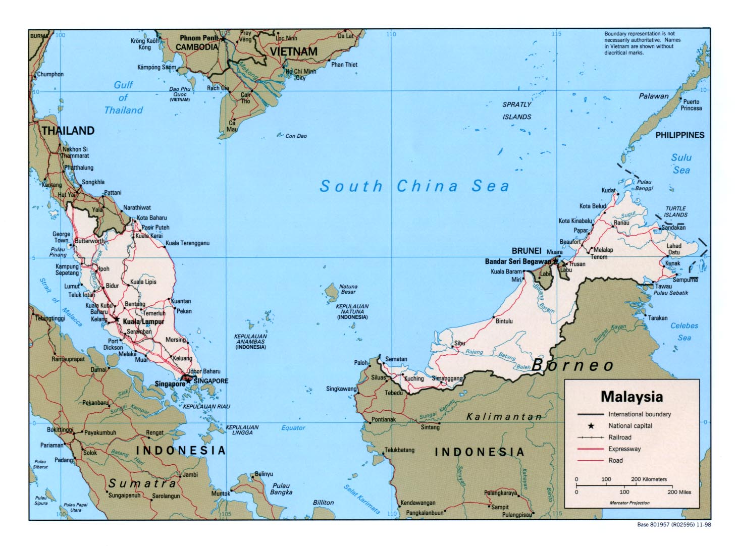