
Mount Tahan
Encyclopedia
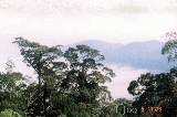
Mount Tahan at 2,187 m, is the highest point in Peninsular Malaysia
. It is located within the Taman Negara national forest, in the state of Pahang
. The mountain is part of the Tahan Range and popular to local climbers.
In Malay language, "gunung" means "mountain" and "tahan" means "endure". Thus the name of the mountain suggests that a certain level of physical endurance is required to conquer the mountain. Gunung Tahan is considered by many to be one of the toughest treks in Peninsular Malaysia.
Climbers without adequate physical fitness or training are not advised to attempt Gunung Tahan.
The other two trails are Merapoh (Sungai Relau) and via Kelantan. Both are significantly shorter than the classic trail from Kuala Tahan. A return trip on the Merapoh trail takes 3–4 days. A traverse from Kuala Tahan to Merapoh (or the other way around) takes around 5 days.
Peninsular Malaysia
Peninsular Malaysia , also known as West Malaysia , is the part of Malaysia which lies on the Malay Peninsula. Its area is . It shares a land border with Thailand in the north. To the south is the island of Singapore. Across the Strait of Malacca to the west lies the island of Sumatra...
. It is located within the Taman Negara national forest, in the state of Pahang
Pahang
Pahang is the third largest state in Malaysia, after Sarawak and Sabah, occupying the huge Pahang River river basin. It is bordered to the north by Kelantan, to the west by Perak, Selangor, Negeri Sembilan, to the south by Johor and to the east by Terengganu and the South China Sea.Its state...
. The mountain is part of the Tahan Range and popular to local climbers.
In Malay language, "gunung" means "mountain" and "tahan" means "endure". Thus the name of the mountain suggests that a certain level of physical endurance is required to conquer the mountain. Gunung Tahan is considered by many to be one of the toughest treks in Peninsular Malaysia.
Trails
The Kuala Tahan classic trail is the oldest and most scenic trail. A return trip on this trail typically takes seven days. Climbers have to trek across undulating ridges and make several river crossings before finally reaching the foot of the mountain to make the final ascent.Climbers without adequate physical fitness or training are not advised to attempt Gunung Tahan.
The other two trails are Merapoh (Sungai Relau) and via Kelantan. Both are significantly shorter than the classic trail from Kuala Tahan. A return trip on the Merapoh trail takes 3–4 days. A traverse from Kuala Tahan to Merapoh (or the other way around) takes around 5 days.
External links
- http://www.mymountaingoal.com/mt_about_g_tahan_trip.htm
- http://www.impressions.com.my/Tahan/gunung_tahan.htm