

Exploration of the Pacific
Encyclopedia
Before Magellan
Models of migration to the New World
There have been several models for the human settlement of the Americas proposed by various academic communities. The question of how, when and why humans first entered the Americas is of intense interest to archaeologists and anthropologists, and has been a subject of heated debate for centuries...
.
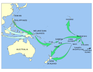
The Polynesians: About 3000BC speakers of the Austronesian languages
Austronesian languages
The Austronesian languages are a language family widely dispersed throughout the islands of Southeast Asia and the Pacific, with a few members spoken on continental Asia that are spoken by about 386 million people. It is on par with Indo-European, Niger-Congo, Afroasiatic and Uralic as one of the...
, probably on the island of Taiwan, mastered the art of long-distance canoe travel and spread themselves, or their languages, south to the Philippines and Indonesia and east to the islands of Micronesia
Micronesia
Micronesia is a subregion of Oceania, comprising thousands of small islands in the western Pacific Ocean. It is distinct from Melanesia to the south, and Polynesia to the east. The Philippines lie to the west, and Indonesia to the southwest....
and Melanesia
Melanesia
Melanesia is a subregion of Oceania extending from the western end of the Pacific Ocean to the Arafura Sea, and eastward to Fiji. The region comprises most of the islands immediately north and northeast of Australia...
. The Polynesians branched off and occupied Polynesia
Polynesia
Polynesia is a subregion of Oceania, made up of over 1,000 islands scattered over the central and southern Pacific Ocean. The indigenous people who inhabit the islands of Polynesia are termed Polynesians and they share many similar traits including language, culture and beliefs...
to the east. Dates and routes are uncertain, but they seem to have started from the Bismark Archipelago, went west past Fiji
Fiji
Fiji , officially the Republic of Fiji , is an island nation in Melanesia in the South Pacific Ocean about northeast of New Zealand's North Island...
to Samoa
Samoa
Samoa , officially the Independent State of Samoa, formerly known as Western Samoa is a country encompassing the western part of the Samoan Islands in the South Pacific Ocean. It became independent from New Zealand in 1962. The two main islands of Samoa are Upolu and one of the biggest islands in...
and Tonga
Tonga
Tonga, officially the Kingdom of Tonga , is a state and an archipelago in the South Pacific Ocean, comprising 176 islands scattered over of ocean in the South Pacific...
about 1500BC. By 100AD they were in the Marquesas Islands
Marquesas Islands
The Marquesas Islands enana and Te Fenua `Enata , both meaning "The Land of Men") are a group of volcanic islands in French Polynesia, an overseas collectivity of France in the southern Pacific Ocean. The Marquesas are located at 9° 00S, 139° 30W...
and 300-800AD in Tahiti
Tahiti
Tahiti is the largest island in the Windward group of French Polynesia, located in the archipelago of the Society Islands in the southern Pacific Ocean. It is the economic, cultural and political centre of French Polynesia. The island was formed from volcanic activity and is high and mountainous...
(Tahiti is west of the Marquesas.) 300-800AD is also given for their arrival at Easter Island
Easter Island
Easter Island is a Polynesian island in the southeastern Pacific Ocean, at the southeasternmost point of the Polynesian triangle. A special territory of Chile that was annexed in 1888, Easter Island is famous for its 887 extant monumental statues, called moai, created by the early Rapanui people...
, their easternmost point and the same date range for Hawaii
Hawaii
Hawaii is the newest of the 50 U.S. states , and is the only U.S. state made up entirely of islands. It is the northernmost island group in Polynesia, occupying most of an archipelago in the central Pacific Ocean, southwest of the continental United States, southeast of Japan, and northeast of...
, which is far to the north and distant from other islands. Far to the southwest, New Zealand
New Zealand
New Zealand is an island country in the south-western Pacific Ocean comprising two main landmasses and numerous smaller islands. The country is situated some east of Australia across the Tasman Sea, and roughly south of the Pacific island nations of New Caledonia, Fiji, and Tonga...
was reached about 1250AD. The Chatham Islands
Chatham Islands
The Chatham Islands are an archipelago and New Zealand territory in the Pacific Ocean consisting of about ten islands within a radius, the largest of which are Chatham Island and Pitt Island. Their name in the indigenous language, Moriori, means Misty Sun...
, about 500 miles east of New Zealand were reached about 1500. The fact that some Polynesians possessed the South American Sweet potato
Sweet potato
The sweet potato is a dicotyledonous plant that belongs to the family Convolvulaceae. Its large, starchy, sweet-tasting, tuberous roots are an important root vegetable. The young leaves and shoots are sometimes eaten as greens. Of the approximately 50 genera and more than 1,000 species of...
implies that they may have reached the Americas, but the evidence of such contacts is very poor.
On the American coast there is no evidence of long-distance sailing or sea contacts between the civilizations of Mexico and Peru.
On the Asian side long-distance trade developed all along the coast from Mozambique to Japan. Trade, and therefore knowledge, extended to the Indonesian Islands but apparently not Australia. By at least 878 when there was a significant Islamic settlement in Canton
Guangzhou
Guangzhou , known historically as Canton or Kwangchow, is the capital and largest city of the Guangdong province in the People's Republic of China. Located in southern China on the Pearl River, about north-northwest of Hong Kong, Guangzhou is a key national transportation hub and trading port...
much of this trade was controlled by Arabs or Muslims. In 219BC Xu Fu
Xu Fu
Xú Fú ; was born in 255 BC in Qi, and served as a court sorcerer in Qin Dynasty China. He was sent by Qin Shi Huang to the eastern seas twice to look for the elixir of life. His two journeys occurred between 219 BC and 210 BC. It was believed that the fleet included 60 barques and around 5,000 crew...
sailed out into the Pacific searching for the elixir of immortality. From 1404-33 Zheng He
Zheng He
Zheng He , also known as Ma Sanbao and Hajji Mahmud Shamsuddin was a Hui-Chinese mariner, explorer, diplomat and fleet admiral, who commanded voyages to Southeast Asia, South Asia, the Middle East, and East Africa, collectively referred to as the Voyages of Zheng He or Voyages of Cheng Ho from...
led expeditions into the Indian Ocean.
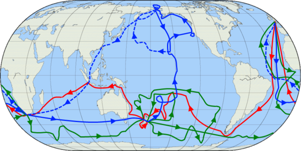
An interesting problem is Japanese fishing boats. If one of these was blown out to sea and lacked proper equipment it would be carried by the current to North America. Japanese boats reached Acapulco in 1617, the Aleutians in 1782, Alaska in 1805, the mouth of the Columbia River in 1820 and Cape Flattery in 1833. If this happened when there were Europeans around to make records, there may have been earlier ones.
From Magellan to Captain Cook
Balboa saw the Pacific in 1513 and Magellan crossed it in 1521. From 1565 the Manila galleons regularly crossed from Mexico to the Philippines and back. On the Asian side the Portuguese and Dutch built a regular trade from the East Indies to Japan and on the American side Spanish power ran from Mexico to Chile. The vast central Pacific was visited only by the Manila galleons and an occasional explorer. This left two great gaps in European knowledge. The south Pacific was crossed a few times by Spaniards who found it empty. The North Pacific was unknown to Europeans, including the whole coast from Japan to California.The Pacific recognized: Europeans knew that there was a vast ocean to the west, and the Chinese knew that there was one to the east. Learned Europeans thought that the world was round and that the two oceans were one. In 1492 Columbus sailed west to what he thought was Asia. When Pedro Álvares Cabral
Pedro Álvares Cabral
Pedro Álvares Cabral was a Portuguese noble, military commander, navigator and explorer regarded as the discoverer of Brazil. Cabral conducted the first substantial exploration of the northeast coast of South America and claimed it for Portugal. While details of Cabral's early life are sketchy, it...
reached Brazil in 1500 the true extent of the Americas began to become known. The Martin Waldseemüller
Martin Waldseemüller
Martin Waldseemüller was a German cartographer...
map of 1507 was the first to show the Americas separating two distinct oceans. This guess was confirmed in 1513 when Balboa crossed Panama and found salt water. The Magellan expedition of 1519-22 proved that there was one continuous ocean from the Americas to Asia. The Diogo Ribeiro map of 1529 was the first to show the Pacific at about its proper size.
The coast of Asia: The first European to see the Pacific Ocean was probably Marco Polo
Marco Polo
Marco Polo was a Venetian merchant traveler from the Venetian Republic whose travels are recorded in Il Milione, a book which did much to introduce Europeans to Central Asia and China. He learned about trading whilst his father and uncle, Niccolò and Maffeo, travelled through Asia and apparently...
about 1292. The Portuguese reached India
Vasco da Gama
Vasco da Gama, 1st Count of Vidigueira was a Portuguese explorer, one of the most successful in the Age of Discovery and the commander of the first ships to sail directly from Europe to India...
in 1498, conquered Malacca
Malacca
Malacca , dubbed The Historic State or Negeri Bersejarah among locals) is the third smallest Malaysian state, after Perlis and Penang. It is located in the southern region of the Malay Peninsula, on the Straits of Malacca. It borders Negeri Sembilan to the north and the state of Johor to the south...
in 1511 and in 1512 António de Abreu
António de Abreu
António de Abreu was a 16th century Portuguese navigator and naval officer. He participated under the command of Afonso de Albuquerque in the conquest of Ormus in 1507 and Malacca in 1511, where he got injured...
reached the Spice Islands
Maluku Islands
The Maluku Islands are an archipelago that is part of Indonesia, and part of the larger Maritime Southeast Asia region. Tectonically they are located on the Halmahera Plate within the Molucca Sea Collision Zone...
. In 1513, the same year that Balboa crossed Panama, Jorge Álvares
Jorge Álvares
Jorge Álvares is credited as the first Portuguese explorer to have reached China and Hong Kong. The Fundação Jorge Álvares , founded by Vasco Joaquim Rocha Vieira prior to the handover of Macau, got its name from him also having reached there.-Exploration:In May 1513 Álvares sailed under the...
reached southern China. Jorge de Menezes
Jorge de Menezes
Jorge de Menezes was a Portuguese explorer who in 1526-27 landed on Waigeo Island , taking shelter in the town of Wasai whilst he awaited the passing of the monsoon season...
in 1526-27 landed on Waigeo Island in New Guinea
New Guinea
New Guinea is the world's second largest island, after Greenland, covering a land area of 786,000 km2. Located in the southwest Pacific Ocean, it lies geographically to the east of the Malay Archipelago, with which it is sometimes included as part of a greater Indo-Australian Archipelago...
, (now part of Indonesia
Indonesia
Indonesia , officially the Republic of Indonesia , is a country in Southeast Asia and Oceania. Indonesia is an archipelago comprising approximately 13,000 islands. It has 33 provinces with over 238 million people, and is the world's fourth most populous country. Indonesia is a republic, with an...
) and named the region Ilhas dos Papuas and is thus credited with the European discovery of Papua
New Guinea
New Guinea is the world's second largest island, after Greenland, covering a land area of 786,000 km2. Located in the southwest Pacific Ocean, it lies geographically to the east of the Malay Archipelago, with which it is sometimes included as part of a greater Indo-Australian Archipelago...
. In 1542 Fernão Mendes Pinto
Fernão Mendes Pinto
Fernão Mendes Pinto was a Portuguese explorer and writer. His exploits are known through the posthumous publication of his memoir Pilgrimage in 1614, an autobiographical work whose truthfulness is nearly impossible to assess...
reached Japan. One hundred years after the Spanish and Portuguese the Dutch Republic began its remarkable expansion. The Dutch reached the East Indies in 1596, the Spice Islands in 1602 and in 1619 founded Batavia
Jakarta Old Town
Kota , is a small area in Jakarta, Indonesia. It is also known as Old Jakarta, and Old Batavia . It spans 1.3 square kilometres of North Jakarta and West Jakarta...
. In 1600 A Dutch fleet
William Adams
-Politicians:*Acton Adams , 19th century New Zealand politician*William Adams , MP for Totnes*William Adams , rancher and politician in British Columbia, Canada...
reached Japan from the Strait of Magellan. The Dutch had little success in China but established themselves at Hirado, Nagasaki
Hirado, Nagasaki
is a city in Nagasaki Prefecture, Japan. The part historically named Hirado is located on the island of the same name. With recent mergers, the city's boundaries have expanded, and Hirado now occupies parts of the main island of Kyūshū...
in 1609 and monopolized the Japan trade from 1639. In 1639 Matthijs Quast
Matthijs Quast
Matthijs Quast was a Dutch explorer in the seventeenth century. He had made several voyages for the VOC to Japan, China and Siam.-Pacific Expedition:Matthijs Quast has become known for an unsuccessful expedition to the Pacific....
and Abel Tasman
Abel Tasman
Abel Janszoon Tasman was a Dutch seafarer, explorer, and merchant, best known for his voyages of 1642 and 1644 in the service of the VOC . His was the first known European expedition to reach the islands of Van Diemen's Land and New Zealand and to sight the Fiji islands...
searched the empty ocean east of Japan looking for two islands called 'Rica de Oro' and 'Rica de Plata'. In 1643 Maarten Gerritsz Vries
Maarten Gerritsz Vries
Maarten Gerritsz Vries, or Fries, also referred to as de Vries, was a 17th-century Dutch cartographer and explorer, the first Western European to leave an account of his visit to the Sea of Okhotsk and the island of Sakhalin.Not much is known about the life of de Vries...
reached Sakhalin
Sakhalin
Sakhalin or Saghalien, is a large island in the North Pacific, lying between 45°50' and 54°24' N.It is part of Russia, and is Russia's largest island, and is administered as part of Sakhalin Oblast...
and the Kuril Islands
Kuril Islands
The Kuril Islands , in Russia's Sakhalin Oblast region, form a volcanic archipelago that stretches approximately northeast from Hokkaidō, Japan, to Kamchatka, Russia, separating the Sea of Okhotsk from the North Pacific Ocean. There are 56 islands and many more minor rocks. It consists of Greater...
. In 1653 Hendrick Hamel
Hendrick Hamel
Hendrick Hamel was the first Westerner to write and experience first-hand in the Joseon Dynasty era in Korea . He later wrote "Hamel's Journal and a Description of the Kingdom of Korea, 1653-1666", published after his return to the Netherlands.Hendrick Hamel was born and died in Gorinchem...
was shipwrecked in Korea. At about this time the Russians reached the Pacific overland via Siberia (see below). It is significant that the Russian and Dutch trades were never linked since Siberian furs might easily have been exported to China at great profit.
Magellan and the Manila Galleons: In 1519 Ferdinand Magellan
Ferdinand Magellan
Ferdinand Magellan was a Portuguese explorer. He was born in Sabrosa, in northern Portugal, and served King Charles I of Spain in search of a westward route to the "Spice Islands" ....
sailed down the east coast of South America, found and sailed through the strait that bears his name
Strait of Magellan
The Strait of Magellan comprises a navigable sea route immediately south of mainland South America and north of Tierra del Fuego...
and on 28 November 1520 entered the Pacific. He then sailed north and caught the trade winds which carried him across the Pacific to the Philippines where he was killed. One surviving ship
Juan Sebastián Elcano
Juan Sebastián Elcano was a Basque Spanish explorer who completed the first circumnavigation of the world. As Ferdinand Magellan's second in command, Elcano took over after Magellan's death in the Philippines.-Early life:Elcano was born to Domingo Sebastián Elcano I and Catalina del Puerto...
returned west across the Indian Ocean and the other
Trinidad (ship)
The Trinidad was the flagship of Ferdinand Magellan's voyage of circumnavigation. Unlike Elcano's Victoria, which returned to Spain, the Trinidad tried and failed to return by way of Mexico. Trinidad was a nao of 100 tons with square sails on the fore and main masts and a lateen mizzen. Its...
went north in the hope of finding the westerlies
Westerlies
The Westerlies, anti-trades, or Prevailing Westerlies, are the prevailing winds in the middle latitudes between 30 and 60 degrees latitude, blowing from the high pressure area in the horse latitudes towards the poles. These prevailing winds blow from the west to the east, and steer extratropical...
and reaching Mexico. Unable to find the right winds, it was forced to return to the East Indies. In 1565 (44 years later) Andrés de Urdaneta
Andrés de Urdaneta
Friar Andrés de Urdaneta, O.S.A., was a circumnavigator, explorer and Augustinian friar. As a navigator he achieved in 1536 the "second" world circumnavigation after first one led by Ferdinand Magellan and Juan Sebastián Elcano in 1522...
found a wind system that would reliably blow a ship eastward back to the Americas. From then until 1815 the annual Manila Galleons crossed the Pacific from Mexico to the Philippines and back, exchanging Mexican silver for spices and porcelain. Until the time of Captain Cook these were the only large ships to regularly cross the Pacific. The route was purely commercial and there was no exploration of the areas to the north and south. In 1668 the Spanish founded a colony on Guam
Guam
Guam is an organized, unincorporated territory of the United States located in the western Pacific Ocean. It is one of five U.S. territories with an established civilian government. Guam is listed as one of 16 Non-Self-Governing Territories by the Special Committee on Decolonization of the United...
as a resting place for west-bound galleons. For a long time this was the only non-coastal European settlement in the Pacific.
South America: In 1513, six years before Magellan, Vasco Núñez de Balboa
Vasco Núñez de Balboa
Vasco Núñez de Balboa was a Spanish explorer, governor, and conquistador. He is best known for having crossed the Isthmus of Panama to the Pacific Ocean in 1513, becoming the first European to lead an expedition to have seen or reached the Pacific from the New World.He traveled to the New World in...
crossed the Isthmus of Panama and saw the Pacific Ocean. In 1517-18 two ships were built on the Pacific coast. In 1522 Pascual de Andagoya
Pascual de Andagoya
Pascual de Andagoya was a Spanish Basque conquistador. He was born in the village of Andagoya, in the valley of Cuartango , in Spain....
went down the coast as far as Ecuador. In 1532 Francisco Pizarro
Francisco Pizarro
Francisco Pizarro González, Marquess was a Spanish conquistador, conqueror of the Incan Empire, and founder of Lima, the modern-day capital of the Republic of Peru.-Early life:...
conquered Peru. A regular trade developed that carried Peruvian silver up the coast to Panama where it was carried overland to the Caribbean and thus to Spain. Spanish settlement extended as far south as central Chile. In 1557-8 Juan Fernández Ladrillero
Juan Fernández Ladrillero
Juan Fernández Ladrillero was a 16th century Spanish navigator and explorer who from 1557 to 1559 explored the coast of Chile from Valdivia to Canal Santa Barbara . He was the first to navigate the Strait of Magellan from its western entrance to its eastern and back again.-Early career:Ladrillero...
explored the islands along the Chilean coast down to the Strait of Magellan.
Álvaro de Mendaña de Neira
Álvaro de Mendaña de Neira was a Spanish navigator. Born in Congosto, in León, he was the nephew of Lope García de Castro, viceroy of Peru...
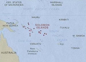
sailed from Peru to the Solomon Islands
Solomon Islands
Solomon Islands is a sovereign state in Oceania, east of Papua New Guinea, consisting of nearly one thousand islands. It covers a land mass of . The capital, Honiara, is located on the island of Guadalcanal...
. In 1595 he tried again and reached the Santa Cruz Islands
Santa Cruz Islands
The Santa Cruz Islands are a group of islands in the Pacific Ocean, part of Temotu Province of the Solomon Islands. They lie approximately 250 miles to the southeast of the Solomon Islands Chain...
(eastern Solomons toward Fiji). He died there and the survivors reached the Philippines. In 1606 Pedro Fernandes de Queirós
Pedro Fernandes de Queirós
Pedro Fernandes de Queirós , was a Portuguese navigator best known for his involvement with Spanish voyages of discovery in the Pacific Ocean, in particular the 1595-1596 voyage of Alvaro de Mendaña de Neira, and for leading a 1605-1606 expedition which crossed the Pacific in search of Terra...
reached Vanuatu
Vanuatu
Vanuatu , officially the Republic of Vanuatu , is an island nation located in the South Pacific Ocean. The archipelago, which is of volcanic origin, is some east of northern Australia, northeast of New Caledonia, west of Fiji, and southeast of the Solomon Islands, near New Guinea.Vanuatu was...
south of the Solomons. He continued exploring, got lost, and sailed to Mexico. One of his separated ships under Luis Vaz de Torres
Luís Vaz de Torres
Luís Vaz de Torres , also Luis Váez de Torres in the Spanish spelling, was a 16th-17th century maritime explorer serving the Spanish Crown, noted for the first recorded navigation of the strait which separates the continent of Australia from the island of New Guinea, and which now bears his name...
went west through the Torres Strait to Manila. In 1722 the Dutchman Jacob Roggeveen sailed from Cape Horn to Batavia and discovered Easter Island and Samoa.
Cape Horn: Six years after Magellan, in 1526, one of the ships of the Loaísa Expedition sailed through the Strait of Magellan and followed the coast north to Mexico. In 1578 Francis Drake
Francis Drake
Sir Francis Drake, Vice Admiral was an English sea captain, privateer, navigator, slaver, and politician of the Elizabethan era. Elizabeth I of England awarded Drake a knighthood in 1581. He was second-in-command of the English fleet against the Spanish Armada in 1588. He also carried out the...
passed through the Strait, sailed north raiding Spanish ships and put it somewhere on the coast of California. In 1580 Pedro Sarmiento de Gamboa
Pedro Sarmiento de Gamboa
Pedro Sarmiento de Gamboa was a Spanish explorer, author, historian, astronomer, and scientist. His birthplace is not certain and may have been Pontevedra, in Galicia, where his paternal family originated or Alcalá de Henares in Castile, where he later is known to have studied...
, who was hunting for Drake, was the first to sail from the Strait to Europe. In 1587 Thomas Cavendish
Thomas Cavendish
Sir Thomas Cavendish was an English explorer and a privateer known as "The Navigator" because he was the first who deliberately tried to emulate Sir Francis Drake and raid the Spanish towns and ships in the Pacific and return by circumnavigating the globe...
followed Drake, captured a Manila galleon and returned via the Indian Ocean. In 1599 the first Dutch ships passed through the Strait of Magellan (Will Adams
William Adams (sailor)
William Adams , also known in Japanese as Anjin-sama and Miura Anjin , was an English navigator who travelled to Japan and is believed to be the first Englishman ever to reach that country...
, the first Englishman to reach Japan, was on board). Olivier van Noort
Olivier van Noort
Olivier van Noort was the first Dutchman to circumnavigate the world.Olivier van Noort was born in 1558 in Utrecht. He left Rotterdam on 2 July 1598 with four ships and a plan to attack Spanish possessions in the Pacific and to trade with China and the Spice Islands...
followed and became the first Dutch circumnavigator.
In 1525 Francisco de Hoces
Francisco de Hoces
Francisco de Hoces was a Spanish sailor who in 1525 joined the Loaísa Expedition to the Spice Islands as commander of the vessel San Lesmes....
, while trying to enter the Strait as part of the Loaisa Expedition, was blown south by a storm and saw what he thought was land's end. In 1578 Drake was blown south on the west side and saw what he thought was open water. In 1616 Willem Schouten
Willem Schouten
Willem Cornelisz Schouten was a Dutch navigator for the Dutch East India Company. He was the first to sail the Cape Horn route to the Pacific Ocean.- Biography :Willem Cornelisz Schouten was born in c...
sought a more southerly passage and rounded Cape Horn
Cape Horn
Cape Horn is the southernmost headland of the Tierra del Fuego archipelago of southern Chile, and is located on the small Hornos Island...
. In 1619 the Garcia de Nodal expedition
Garcia de Nodal expedition
The García de Nodal expedition was chartered in 1619 by King Philip III of Spain to reconnoiter the passage between the Atlantic and Pacific oceans, rounding Cape Horn, south of Tierra del Fuego, just discovered by the Dutch merchants Jacob Le Maire and Willem Schouten. It was a successful...
followed the Dutch and proved that Tierra del Fuego was an island by circumnavigating it. Since the Strait of Magellan is narrow and hard to navigate Cape Horn became the standard route until the opening of the Panama Canal. It is a measure of the difficulty of these seas that it was not until 1820 that anyone went as far south as Antarctica.
North America: When the Spanish conquered Mexico in 1521 they gained a stretch of Pacific coast. In 1533, Fortún Ximénez
Fortún Ximénez
Fortún Ximénez was Spanish sailor who led a mutiny during an early expedition along the coast of Mexico and is the first European known to have landed in Baja California....
reached Baja California
Baja California
Baja California officially Estado Libre y Soberano de Baja California is one of the 31 states which, with the Federal District, comprise the 32 Federal Entities of Mexico. It is both the northernmost and westernmost state of Mexico. Before becoming a state in 1953, the area was known as the North...
and in 1539 Francisco de Ulloa
Francisco de Ulloa
Francisco de Ulloa was a Spanish explorer who explored the west coast of present-day Mexico under the commission of Hernán Cortés...
showed that it was a peninsula, but the myth of an Island of California
Island of California
The Island of California refers to a long-held European misconception, dating from the 16th century, that California was not part of mainland North America but rather a large island separated from the continent by a strait now known instead as the Gulf of California.One of the most famous...
continued for many years. In 1542 Juan Rodriguez Cabrillo
Juan Rodríguez Cabrillo
Juan Rodriguez Cabrillo was a Portuguese explorer noted for his exploration of the west coast of North America on behalf of Spain. Cabrillo was the first European explorer to navigate the coast of present day California in the United States...
reached a point north of San Francisco. In 1578 Drake landed somewhere on the coast. In 1587 Pedro de Unamuno, coming from the Philippines, stopped at Morro Bay, California
Morro Bay, California
Morro Bay is a waterfront city in San Luis Obispo County, California, United States. As of the 2010 census, the city population was 10,234, down from 10,350 at the 2000 census.- History :...
. In 1592 Juan de Fuca
Juan de Fuca
Ioánnis Fokás , better known by the Spanish transcription of his name, Juan de Fuca , was a Greek-born maritime pilot in the service of the king of Spain, Philip II...
may have reached Puget Sound
Puget Sound
Puget Sound is a sound in the U.S. state of Washington. It is a complex estuarine system of interconnected marine waterways and basins, with one major and one minor connection to the Strait of Juan de Fuca and the Pacific Ocean — Admiralty Inlet being the major connection and...
. In 1602 Sebastián Vizcaíno
Sebastián Vizcaíno
Sebastián Vizcaíno was a Spanish soldier, entrepreneur, explorer, and diplomat whose varied roles took him to New Spain, the Philippines, the Baja California peninsula, the California coast and Japan.-Early career:...
re-explored the California coast, one of his ships reaching Oregon. His was the last northward exploration for the next 150 years.
After conquering Mexico the Spanish occupied the southern two thirds of Mexico, all of Central America and the South American coast down to Chile. North of this the land was too dry to support a dense population that could be ruled and taxed. The only exception was the Pueblo
Pueblo
Pueblo is a term used to describe modern communities of Native Americans in the Southwestern United States of America. The first Spanish explorers of the Southwest used this term to describe the communities housed in apartment-like structures built of stone, adobe mud, and other local material...
peoples far to the north in New Mexico. People like Francisco Vásquez de Coronado
Francisco Vásquez de Coronado
Francisco Vásquez de Coronado y Luján was a Spanish conquistador, who visited New Mexico and other parts of what are now the southwestern United States between 1540 and 1542...
penetrated far into the interior and found nothing that the Spanish valued. The Chichimeca
Chichimeca
Chichimeca was the name that the Nahua peoples of Mexico generically applied to a wide range of semi-nomadic peoples who inhabited the north of modern-day Mexico and southwestern United States, and carried the same sense as the European term "barbarian"...
country of northern Mexico was slowly absorbed and Baja California began to be settled in 1687. The returning Manila galleons followed the westerlies
Westerlies
The Westerlies, anti-trades, or Prevailing Westerlies, are the prevailing winds in the middle latitudes between 30 and 60 degrees latitude, blowing from the high pressure area in the horse latitudes towards the poles. These prevailing winds blow from the west to the east, and steer extratropical...
to the coast of California, but immediately turned south, making only a few attempts to explore the coast. For more see History of the West Coast of North America
History of the west coast of North America
The human history of the west coast of North America is believed to stretch back to the arrival of the earliest people over the Bering Strait, or alternately along a now-submerged coastal plain, through the development of significant pre-Columbian cultures and population densities, to the arrival...
.
Theory of Portuguese discovery of Australia
Although most historians hold that the European discovery of Australia began in 1606 with the voyage of the Dutch navigator Willem Janszoon on board the Duyfken, a theory exists that a Portuguese expedition arrived in Australia between 1521 and 1524...
are difficult to prove. The 1567-1606 Spanish voyages from South America stopped at islands to the east before reaching Australia. The first European to definitely see Australia was Willem Janszoon
Willem Janszoon
Willem Janszoon , Dutch navigator and colonial governor, is probably the first European known to have seen the coast of Australia. His name is sometimes abbreviated to Willem Jansz....
who in February 1606 reached the Cape York Peninsula and thought it was part of New Guinea. Also in 1606 (June to October) Luis Váez de Torres of the Quiros expedition from South America followed the south coast of New Guinea and passed through the Torres Strait
Torres Strait
The Torres Strait is a body of water which lies between Australia and the Melanesian island of New Guinea. It is approximately wide at its narrowest extent. To the south is Cape York Peninsula, the northernmost continental extremity of the Australian state of Queensland...
without recognizing Australia. His voyage, and therefore the separation between Australia and New Guinea, was not generally known until 1765. From about 1611 the standard Dutch route
Brouwer Route
The Brouwer Route was a route for sailing from the Cape of Good Hope to Java. The Route took ships south from the Cape into the Roaring Forties, then east across the Indian Ocean, before turning northwest for Java...
to the East Indies was to follow the roaring forties
Roaring Forties
The Roaring Forties is the name given to strong westerly winds found in the Southern Hemisphere, generally between the latitudes of 40 and 49 degrees. Air displaced from the Equator towards the South Pole, which travels close to the surface between the latitudes of 30 and 60 degrees south, combines...
as far east as possible and then turn sharply north to Batavia
Jakarta Old Town
Kota , is a small area in Jakarta, Indonesia. It is also known as Old Jakarta, and Old Batavia . It spans 1.3 square kilometres of North Jakarta and West Jakarta...
. Since it was difficult to know longitude some ships would reach the west coast or be wrecked on it
Brouwer Route
The Brouwer Route was a route for sailing from the Cape of Good Hope to Java. The Route took ships south from the Cape into the Roaring Forties, then east across the Indian Ocean, before turning northwest for Java...
. 1616 Dirk Hartog
Dirk Hartog
Dirk Hartog was a 17th century Dutch sailor and explorer. Dirk Hartog's expedition was the third European group to land on Australian soil. He was the first to leave behind an artifact to record his visit, the Hartog plate. His name is sometimes alternatively spelled Dirck Hartog or Dierick...
bumped into the west coast and did some exploring. Frederick de Houtman
Frederick de Houtman
Frederick de Houtman , or Frederik de Houtman, was a Dutch explorer who sailed along the Western coast of Australia en route to Batavia.-Biography:...
did the same in 1619. In 1623 Jan Carstenszoon
Jan Carstenszoon
Jan Carstenszoon or more commonly Jan Carstensz ) was a 17th century Dutch explorer.In 1623, Carstenszoon was commissioned by the Dutch East India Company to lead an expedition to the southern coast of New Guinea and beyond, to follow up the reports of land sighted further south in the 1606 voyages...
followed the south coast of New Guinea, missed Torres Strait and went along the north coast of Australia. In 1643 Abel Tasman
Abel Tasman
Abel Janszoon Tasman was a Dutch seafarer, explorer, and merchant, best known for his voyages of 1642 and 1644 in the service of the VOC . His was the first known European expedition to reach the islands of Van Diemen's Land and New Zealand and to sight the Fiji islands...
left Mauritus, missed Australia, found Tasmania
Tasmania
Tasmania is an Australian island and state. It is south of the continent, separated by Bass Strait. The state includes the island of Tasmania—the 26th largest island in the world—and the surrounding islands. The state has a population of 507,626 , of whom almost half reside in the greater Hobart...
, continued east and found New Zealand
New Zealand
New Zealand is an island country in the south-western Pacific Ocean comprising two main landmasses and numerous smaller islands. The country is situated some east of Australia across the Tasman Sea, and roughly south of the Pacific island nations of New Caledonia, Fiji, and Tonga...
, missed the strait between the north and south islands, turned northwest, missed Australia again and sailed along the north coast of New Guinea. In 1644 he followed the south coast of New Guinea, missed the Torres Strait, turned south and mapped the north coast of Australia. In 1688 the English buccaneer William Dampier
William Dampier
William Dampier was an English buccaneer, sea captain, author and scientific observer...
beached a ship on the northwest coast. In 1696 Willem de Vlamingh
Willem de Vlamingh
Willem Hesselsz de Vlamingh was a Dutch sea-captain who explored the central west coast of Australia in the late 17th century.- Vlamingh and the VOC :...
explored the southwest coast. In 1699 Dampier was sent to find the east coast of Australia. He sailed along the west coast, went north to Timor, followed the north coast of New Guinea to the Bismark Archipelago and abandoned his search because his ship had become rotten. Until Captain Cook the east coast was completely unknown and New Zealand had only been seen once.
Pacific Islands: See also History of the Pacific Islands
History of the Pacific Islands
History of the Pacific Islands covers the history of the islands in the Pacific Ocean.-Easter Island – Rapanui:Easter Island is one of the youngest inhabited territories on Earth, and for most of the History of Easter Island it was the most isolated inhabited territory on Earth...
- 1521: GuamGuamGuam is an organized, unincorporated territory of the United States located in the western Pacific Ocean. It is one of five U.S. territories with an established civilian government. Guam is listed as one of 16 Non-Self-Governing Territories by the Special Committee on Decolonization of the United...
and the Mariana IslandsMariana IslandsThe Mariana Islands are an arc-shaped archipelago made up by the summits of 15 volcanic mountains in the north-western Pacific Ocean between the 12th and 21st parallels north and along the 145th meridian east...
by Magellan. - 1525: Caroline IslandsCaroline IslandsThe Caroline Islands are a widely scattered archipelago of tiny islands in the western Pacific Ocean, to the north of New Guinea. Politically they are divided between the Federated States of Micronesia in the eastern part of the group, and Palau at the extreme western end...
by Diogo da Rocha from the Portuguese East Indies - 1526: Marshall IslandsMarshall IslandsThe Republic of the Marshall Islands , , is a Micronesian nation of atolls and islands in the middle of the Pacific Ocean, just west of the International Date Line and just north of the Equator. As of July 2011 the population was 67,182...
by Alonso de SalazarAlonso de SalazarAlonso de Salazar was the Spaniard who discovered the Marshall Islands on August 21, 1526. De Salazar was in command of Santa Maria de la Victoria but is not known to have landed. He is believed to have sighted the Bokak Atoll...
of the Loisa expedition - 1543: Bonin Islands south of Japan by Bernardo de la TorreBernardo de la TorreBernardo de la Torre was a Spanish sailor, primarily noted for having explored parts of the Western Pacific Ocean south of Japan in the 16th century.-Exploration:...
from Mexico - 1568: Solomon IslandsSolomon IslandsSolomon Islands is a sovereign state in Oceania, east of Papua New Guinea, consisting of nearly one thousand islands. It covers a land mass of . The capital, Honiara, is located on the island of Guadalcanal...
, TuvaluTuvaluTuvalu , formerly known as the Ellice Islands, is a Polynesian island nation located in the Pacific Ocean, midway between Hawaii and Australia. Its nearest neighbours are Kiribati, Nauru, Samoa and Fiji. It comprises four reef islands and five true atolls...
and Wake IslandWake IslandWake Island is a coral atoll having a coastline of in the North Pacific Ocean, located about two-thirds of the way from Honolulu west to Guam east. It is an unorganized, unincorporated territory of the United States, administered by the Office of Insular Affairs, U.S. Department of the Interior...
by Álvaro de Mendaña de NeiraÁlvaro de Mendaña de NeiraÁlvaro de Mendaña de Neira was a Spanish navigator. Born in Congosto, in León, he was the nephew of Lope García de Castro, viceroy of Peru...
from South America - 1574: Juan Fernández IslandsJuan Fernández IslandsThe Juan Fernández Islands are a sparsely inhabited island group reliant on tourism and fishing in the South Pacific Ocean, situated about off the coast of Chile, and is composed of three main volcanic islands; Robinson Crusoe Island, Alejandro Selkirk Island and Santa Clara Island, the first...
by Juan Fernández, accidentally - 1595: Marquesas IslandsMarquesas IslandsThe Marquesas Islands enana and Te Fenua `Enata , both meaning "The Land of Men") are a group of volcanic islands in French Polynesia, an overseas collectivity of France in the southern Pacific Ocean. The Marquesas are located at 9° 00S, 139° 30W...
and Santa Cruz IslandsSanta Cruz IslandsThe Santa Cruz Islands are a group of islands in the Pacific Ocean, part of Temotu Province of the Solomon Islands. They lie approximately 250 miles to the southeast of the Solomon Islands Chain...
by Álvaro de Mendaña de NeiraÁlvaro de Mendaña de NeiraÁlvaro de Mendaña de Neira was a Spanish navigator. Born in Congosto, in León, he was the nephew of Lope García de Castro, viceroy of Peru...
from South America - 1606: Tuamotu Archipelago and New HebridesNew HebridesNew Hebrides was the colonial name for an island group in the South Pacific that now forms the nation of Vanuatu. The New Hebrides were colonized by both the British and French in the 18th century shortly after Captain James Cook visited the islands...
(Vanuatu) by Pedro Fernández de Quirós from South America - 1616: TongaTongaTonga, officially the Kingdom of Tonga , is a state and an archipelago in the South Pacific Ocean, comprising 176 islands scattered over of ocean in the South Pacific...
and the Bismark Archipelago by Willem SchoutenWillem SchoutenWillem Cornelisz Schouten was a Dutch navigator for the Dutch East India Company. He was the first to sail the Cape Horn route to the Pacific Ocean.- Biography :Willem Cornelisz Schouten was born in c...
from Cape Horn. - 1643: TasmaniaTasmaniaTasmania is an Australian island and state. It is south of the continent, separated by Bass Strait. The state includes the island of Tasmania—the 26th largest island in the world—and the surrounding islands. The state has a population of 507,626 , of whom almost half reside in the greater Hobart...
, New ZealandNew ZealandNew Zealand is an island country in the south-western Pacific Ocean comprising two main landmasses and numerous smaller islands. The country is situated some east of Australia across the Tasman Sea, and roughly south of the Pacific island nations of New Caledonia, Fiji, and Tonga...
and FijiFijiFiji , officially the Republic of Fiji , is an island nation in Melanesia in the South Pacific Ocean about northeast of New Zealand's North Island...
by Abel TasmanAbel TasmanAbel Janszoon Tasman was a Dutch seafarer, explorer, and merchant, best known for his voyages of 1642 and 1644 in the service of the VOC . His was the first known European expedition to reach the islands of Van Diemen's Land and New Zealand and to sight the Fiji islands... - 1722: Easter IslandEaster IslandEaster Island is a Polynesian island in the southeastern Pacific Ocean, at the southeasternmost point of the Polynesian triangle. A special territory of Chile that was annexed in 1888, Easter Island is famous for its 887 extant monumental statues, called moai, created by the early Rapanui people...
and SamoaSamoaSamoa , officially the Independent State of Samoa, formerly known as Western Samoa is a country encompassing the western part of the Samoan Islands in the South Pacific Ocean. It became independent from New Zealand in 1962. The two main islands of Samoa are Upolu and one of the biggest islands in...
by Jacob Roggeveen from Cape Horn - 1741: Aleutian Islands by Vitus BeringVitus BeringVitus Jonassen Bering Vitus Jonassen Bering Vitus Jonassen Bering (also, less correNavy]], a captain-komandor known among the Russian sailors as Ivan Ivanovich. He is noted for being the first European to discover Alaska and its Aleutian Islands...
and Alexei Chirikov from Russia - 1767: TahitiTahitiTahiti is the largest island in the Windward group of French Polynesia, located in the archipelago of the Society Islands in the southern Pacific Ocean. It is the economic, cultural and political centre of French Polynesia. The island was formed from volcanic activity and is high and mountainous...
by Samuel WallisSamuel WallisSamuel Wallis was a Cornish navigator who circumnavigated the world.Wallis was born near Camelford, Cornwall. In 1766 he was given the command of HMS Dolphin to circumnavigate the world, accompanied by the Swallow under the command of Philip Carteret... - 1767: Pitcairn Island by Philip CarteretPhilip CarteretPhilip Carteret, Seigneur of Trinity was a British naval officer and explorer who participated in two of the Royal Navy's circumnavigation expeditions in 1764-66 and 1766-69.-Biography:...
- 1774: New CaledoniaNew CaledoniaNew Caledonia is a special collectivity of France located in the southwest Pacific Ocean, east of Australia and about from Metropolitan France. The archipelago, part of the Melanesia subregion, includes the main island of Grande Terre, the Loyalty Islands, the Belep archipelago, the Isle of...
and Norfolk IslandNorfolk IslandNorfolk Island is a small island in the Pacific Ocean located between Australia, New Zealand and New Caledonia. The island is part of the Commonwealth of Australia, but it enjoys a large degree of self-governance...
by James CookJames CookCaptain James Cook, FRS, RN was a British explorer, navigator and cartographer who ultimately rose to the rank of captain in the Royal Navy... - 1778: Hawaiian IslandsHawaiian IslandsThe Hawaiian Islands are an archipelago of eight major islands, several atolls, numerous smaller islets, and undersea seamounts in the North Pacific Ocean, extending some 1,500 miles from the island of Hawaii in the south to northernmost Kure Atoll...
by James CookJames CookCaptain James Cook, FRS, RN was a British explorer, navigator and cartographer who ultimately rose to the rank of captain in the Royal Navy... - 1788: Gilbert IslandsGilbert IslandsThe Gilbert Islands are a chain of sixteen atolls and coral islands in the Pacific Ocean. They are the main part of Republic of Kiribati and include Tarawa, the site of the country's capital and residence of almost half of the population.-Geography:The atolls and islands of the Gilbert Islands...
(Kiribati) by Thomas GilbertThomas GilbertThomas Gilbert was an English land agent. One of the earliest advocates of poor relief, he played a major part in the Relief of the Poor Act of 1782.- Early life :... - 1791: Chatham IslandsChatham IslandsThe Chatham Islands are an archipelago and New Zealand territory in the Pacific Ocean consisting of about ten islands within a radius, the largest of which are Chatham Island and Pitt Island. Their name in the indigenous language, Moriori, means Misty Sun...
by William R. Broughton
Mythical Lands: Europeans had long believed in a Strait of Anian somewhere near Bering Strait. A large and distorted Hokkaido
Hokkaido
, formerly known as Ezo, Yezo, Yeso, or Yesso, is Japan's second largest island; it is also the largest and northernmost of Japan's 47 prefectural-level subdivisions. The Tsugaru Strait separates Hokkaido from Honshu, although the two islands are connected by the underwater railway Seikan Tunnel...
was called 'Ezo
Ezo
is a Japanese name which historically referred to the lands to the north of Japan. It was used in various senses, sometimes meaning the northern Japanese island of Hokkaidō, and sometimes meaning lands and waters further north in the Sea of Okhotsk, like Sakhalin and the Kuril Islands...
', 'Jesso' and many other spellings. One of the Kuril Islands
Kuril Islands
The Kuril Islands , in Russia's Sakhalin Oblast region, form a volcanic archipelago that stretches approximately northeast from Hokkaidō, Japan, to Kamchatka, Russia, separating the Sea of Okhotsk from the North Pacific Ocean. There are 56 islands and many more minor rocks. It consists of Greater...
named "Companies Landt" by Vries grew into a large mass attached to North America. Joao-da-Gama-Land was thought to be east of Japan. There was an overgrown Puget Sound called "Grande Mer de l'Ouest" possibly connected to Hudson Bay
Hudson Bay
Hudson Bay , sometimes called Hudson's Bay, is a large body of saltwater in northeastern Canada. It drains a very large area, about , that includes parts of Ontario, Quebec, Saskatchewan, Alberta, most of Manitoba, southeastern Nunavut, as well as parts of North Dakota, South Dakota, Minnesota,...
. In the far south was a Terra Australis
Terra Australis
Terra Australis, Terra Australis Ignota or Terra Australis Incognita was a hypothesized continent appearing on European maps from the 15th to the 18th century...
. The map published in Diderot's Encyclopédie
Encyclopédie
Encyclopédie, ou dictionnaire raisonné des sciences, des arts et des métiers was a general encyclopedia published in France between 1751 and 1772, with later supplements, revised editions, and translations. It was edited by Denis Diderot and Jean le Rond d'Alembert...
in 1755 is filled with nonsense. In 1875 no less than 123 mythical islands
Phantom island
Phantom islands are islands that were believed to exist, and appeared on maps for a period of time during recorded history, but were later removed after they were proved to be nonexistent...
were removed from the Royal Navy chart
Admiralty chart
Admiralty charts are nautical charts issued by the United Kingdom Hydrographic Office and subject to Crown Copyright. Over 3,000 charts are available and cover virtually the entire world in various levels of detail depending on the density of traffic and hazards...
of the North Pacific.
Captain Cook and after
Siberian River Routes
Siberian River Routes were the main ways of communication in the Russian Siberia before the 1730s, when roads began to be built. The rivers also were of primary importance in the process of Russian exploration and colonisation of vast Siberian territories...
and reached the Pacific in 1639 (Ivan Moskvitin
Ivan Moskvitin
Ivan Yuryevich Moskvitin was a Russian explorer, presumably a native of Moscow, who led a Russian reconnaissance party to the Pacific Ocean, becoming the first Russian to reach the Sea of Okhotsk....
). In 1644 Vassili Poyarkov
Vassili Poyarkov
Vassili Danilovich Poyarkov was the first Russian explorer of the Amur region.The Russian expansion into Siberia began with the conquest of the Khanate of Sibir in 1582. By 1643 they reached the Pacific at Okhotsk...
found the Amur River. In 1648 Semyon Dezhnyov (probably) entered the Pacific from the Arctic Ocean. In 1652 Mikhail Stadukhin
Mikhail Stadukhin
Mikhail Vasilyevich Stadukhin was a Russian explorer of far northeast Siberia, one of the first to reach the Kolyma, Anadyr, Penzhina and Gizhiga Rivers and the northern Sea of Okhotsk. He was a Pomor, probably born in the village of Pinega, and the nephew of a Moscow merchant...
followed the coast of the Sea of Okhotsk
Sea of Okhotsk
The Sea of Okhotsk is a marginal sea of the western Pacific Ocean, lying between the Kamchatka Peninsula on the east, the Kuril Islands on the southeast, the island of Hokkaidō to the far south, the island of Sakhalin along the west, and a long stretch of eastern Siberian coast along the west and...
. In 1697 Vladimir Atlasov
Vladimir Atlasov
Vladimir Vasilyevich Atlasov or Otlasov was a Siberian Cossack who was the first Russian to explore the Kamchatka Peninsula. Atlasov Island, an uninhabited volcanic island off the southern tip of Kamchatka, is named after him....
entered the Kamchatka Peninsula
Kamchatka Peninsula
The Kamchatka Peninsula is a peninsula in the Russian Far East, with an area of . It lies between the Pacific Ocean to the east and the Sea of Okhotsk to the west...
from the north. In 1716 the first sea-going boats were built to reach Kamchatka from the mainland. In 1728 Vitus Bering
Vitus Bering
Vitus Jonassen Bering Vitus Jonassen Bering Vitus Jonassen Bering (also, less correNavy]], a captain-komandor known among the Russian sailors as Ivan Ivanovich. He is noted for being the first European to discover Alaska and its Aleutian Islands...
sailed from Kamchatka through the strait that bears his name
Bering Strait
The Bering Strait , known to natives as Imakpik, is a sea strait between Cape Dezhnev, Chukotka Autonomous Okrug, Russia, the easternmost point of the Asian continent and Cape Prince of Wales, Alaska, USA, the westernmost point of the North American continent, with latitude of about 65°40'N,...
without seeing America. In 1732 Mikhail Gvozdev
Mikhail Gvozdev
Mikhail Spiridonovich Gvozdev was a Russian military geodesist and a commander of the expedition to northern Alaska in 1732, when Alaskan shore was for the first time sited by Russians....
and Ivan Fedorov (navigator) saw the tip of Alaska from the Bering Strait. In 1741 Vitus Bering
Vitus Bering
Vitus Jonassen Bering Vitus Jonassen Bering Vitus Jonassen Bering (also, less correNavy]], a captain-komandor known among the Russian sailors as Ivan Ivanovich. He is noted for being the first European to discover Alaska and its Aleutian Islands...
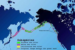
and Alexei Chirikov sailed just south of the Aleutian Islands and reached the Alaska panhandle. Peter Kuzmich Krenitzin mapped the Aleutians before 1769. The myth of a land mass north of the Aleutians took a long time to dispel. Russians fur hunters island-hopped along the Aleutians and then along the south coast of Alaska looking mainly for sea otter
Sea Otter
The sea otter is a marine mammal native to the coasts of the northern and eastern North Pacific Ocean. Adult sea otters typically weigh between 14 and 45 kg , making them the heaviest members of the weasel family, but among the smallest marine mammals...
(Attu
Attu
Attu may refer to:*A common name for the Dosa in Telugu*Attu Island in Alaska*The Battle of Attu, the primary land battle in the Aleutian Islands campaign of World War II, which took place on Attu Island in May 1943....
at the west end of the Aleutians in 1745, Unalaska Island
Unalaska Island
Unalaska is an island in the Fox Islands group of the Aleutian Islands in the U.S. state of Alaska, at . The island has a land area of . The city of Unalaska, Alaska, covers part of the island and all of neighboring Amaknak Island where the Port of Dutch Harbor is located...
at the east end in 1759, Kodiak Island
Kodiak Island
Kodiak Island is a large island on the south coast of the U.S. state of Alaska, separated from the Alaska mainland by the Shelikof Strait. The largest island in the Kodiak Archipelago, Kodiak Island is the second largest island in the United States and the 80th largest island in the world, with an...
1784, Kenai Peninsula
Kenai Peninsula
The Kenai Peninsula is a large peninsula jutting from the southern coast of Alaska in the United States. The name Kenai is probably derived from Kenayskaya, the Russian name for Cook Inlet, which borders the peninsula to the west.-Geography:...
1785, Yakutat
Yakutat
Yakutat may refer to:Geography*Yakutat Airport, a state-owned public-use airport in Alaska in the United States*Yakutat Bay, a bay on the coast of Alaska*Yakutat City and Borough, Alaska, a unified city-borough in AlaskaGeology...
, 1795, Sitka 1799, Fort Ross 1812). North of the Aleutians posts appeared on the west coast after 1819. Spaniards from Mexico met the Russians in 1788. (see below). Russian America was sold to the United States in 1867.
James Cook
Captain James Cook, FRS, RN was a British explorer, navigator and cartographer who ultimately rose to the rank of captain in the Royal Navy...
went to Tahiti from Cape Horn, circumnavigated New Zealand
New Zealand
New Zealand is an island country in the south-western Pacific Ocean comprising two main landmasses and numerous smaller islands. The country is situated some east of Australia across the Tasman Sea, and roughly south of the Pacific island nations of New Caledonia, Fiji, and Tonga...
, followed the east coast of Australia for the first time and returned via the Torres Strait and the Cape of Good Hope. On his second voyage (1772-75) he sailed from west to east keeping as far south as possible and showed that there was probably no Terra Australis
Terra Australis
Terra Australis, Terra Australis Ignota or Terra Australis Incognita was a hypothesized continent appearing on European maps from the 15th to the 18th century...
. On his third voyage (1776-80) he found the Hawaiian Islands
Hawaiian Islands
The Hawaiian Islands are an archipelago of eight major islands, several atolls, numerous smaller islets, and undersea seamounts in the North Pacific Ocean, extending some 1,500 miles from the island of Hawaii in the south to northernmost Kure Atoll...
and followed the North American coast from Oregon to the Bering Strait, mapping this coast for the first time and showing that there was probably no Northwest passage
Northwest Passage
The Northwest Passage is a sea route through the Arctic Ocean, along the northern coast of North America via waterways amidst the Canadian Arctic Archipelago, connecting the Atlantic and Pacific Oceans...
. Cook was killed in Hawaii in 1779. The expedition made a second attempt at the Bering Strait, stopped at Kamchatka and China and reached England in 1780. Cook set a high standard of scientific exploration, showed that there was no large land mass in the southern ocean, mapped the two largest island groups in the Pacific and by following the east coast of Australia and the west coast of North America closed the last gaps in European knowledge of the Pacific coasts. After Cook everything was detail.
Cook's rivals and successors: Several governments sponsored Pacific expeditions, often in rivalry or emulation of Captain Cook. At the time of Cook's first voyage, in 1766-69 Louis Antoine de Bougainville
Louis Antoine de Bougainville
Louis-Antoine, Comte de Bougainville was a French admiral and explorer. A contemporary of James Cook, he took part in the French and Indian War and the unsuccessful French attempt to defend Canada from Britain...
crossed the Pacific and publicized Tahiti and in 1767 Samuel Wallis
Samuel Wallis
Samuel Wallis was a Cornish navigator who circumnavigated the world.Wallis was born near Camelford, Cornwall. In 1766 he was given the command of HMS Dolphin to circumnavigate the world, accompanied by the Swallow under the command of Philip Carteret...
and Philip Carteret
Philip Carteret
Philip Carteret, Seigneur of Trinity was a British naval officer and explorer who participated in two of the Royal Navy's circumnavigation expeditions in 1764-66 and 1766-69.-Biography:...
separately crossed the Pacific. In 1785-88 Jean-François de Galaup, comte de Lapérouse followed the American coast from Chile to Alaska, crossed to China, explored northern Japan and Kamchatka, went south to Australia and lost his life in the Santa Cruz Islands
Santa Cruz Islands
The Santa Cruz Islands are a group of islands in the Pacific Ocean, part of Temotu Province of the Solomon Islands. They lie approximately 250 miles to the southeast of the Solomon Islands Chain...
. The Malaspina Expedition
Malaspina Expedition
The Malaspina Expedition was a scientific exploration that took place during a five-year voyage around the globe, commanded by Alessandro Malaspina and José de Bustamante y Guerra. Although the expedition receives its name from Malaspina, he always insisted on giving Bustamante an equal share of...
(1789-1794) visited the American coast, Manila, New Zealand and Australia. In 1791-95 George Vancouver
George Vancouver
Captain George Vancouver RN was an English officer of the British Royal Navy, best known for his 1791-95 expedition, which explored and charted North America's northwestern Pacific Coast regions, including the coasts of contemporary Alaska, British Columbia, Washington and Oregon...
more thoroughly mapped the west coast of Canada. In 1803/6 Adam Johann von Krusenstern
Adam Johann von Krusenstern
Adam Johann Ritter von Krusenstern , was an admiral and explorer, who led the first Russian circumnavigation of the globe.- Life :...
led the first Russian circumnavigation and investigated both sides of the North Pacific. In 1820 Fabian Gottlieb von Bellingshausen
Fabian Gottlieb von Bellingshausen
Fabian Gottlieb Thaddeus von Bellingshausen was an officer in the Imperial Russian Navy, cartographer and explorer, who ultimately rose to the rank of Admiral...
saw Antarctica. A number of other voyages are listed in "European and American voyages of scientific exploration
European and American voyages of scientific exploration
The era of European and American voyages of scientific exploration followed the Age of Discovery and were inspired by a new confidence in science and reason that arose in the Age of Enlightenment...
."
Spain versus England and Russia on the west coast of North America: For Europeans in the age of sail western North America was one of the most distant places on earth (9 to 12 months of sailing). Spain had long claimed the entire west coast of the Americas but paid little attention to the area north of Mexico. This changed when the Russians appeared in Alaska. The Spanish pushed north to California and built a series of missions
Spanish missions in California
The Spanish missions in California comprise a series of religious and military outposts established by Spanish Catholics of the Franciscan Order between 1769 and 1823 to spread the Christian faith among the local Native Americans. The missions represented the first major effort by Europeans to...
: San Diego in 1767, Monterey, California
Monterey, California
The City of Monterey in Monterey County is located on Monterey Bay along the Pacific coast in Central California. Monterey lies at an elevation of 26 feet above sea level. As of the 2010 census, the city population was 27,810. Monterey is of historical importance because it was the capital of...
in 1770 and San Francisco in 1776. (San Francisco Bay was first seen in 1769 by Gaspar de Portolà
Gaspar de Portolà
Gaspar de Portolà i Rovira was a soldier, governor of Baja and Alta California , explorer and founder of San Diego and Monterey. He was born in Os de Balaguer, province of Lleida, in Catalonia, Spain, of Catalan nobility. Don Gaspar served as a soldier in the Spanish army in Italy and Portugal...
from the landward side because its mouth is not obvious from the sea.) San Francisco remained the northern limit of land occupation. By sea, from 1774 to 1793 the Spanish expeditions to the Pacific Northwest tried to assert Spanish claims against the Russians and British. In 1774 Juan José Pérez Hernández
Juan José Pérez Hernández
Juan José Pérez Hernández , often simply Juan Pérez, was an 18th century Spanish explorer. He was the first European to sight, examine, name, and record the islands near present-day British Columbia, Canada...
reached what is now the south end of the Alaska panhandle. In 1778 Captain Cook sailed the west coast and spent a month at Nootka Sound
Nootka Sound
Nootka Sound is a complex inlet or sound of the Pacific Ocean on the rugged west coast of Vancouver Island, in the Canadian province of British Columbia. Historically also known as King George's Sound, as a strait it separates Vancouver Island and Nootka Island.-History:The inlet is part of the...
on Vancouver Island. Spain and England being at war, Juan Francisco de la Bodega y Quadra
Juan Francisco de la Bodega y Quadra
Juan Francisco de la Bodega y Quadra was a Spanish naval officer born in Lima, Peru. Assigned to the Pacific coast Spanish Naval Department base at San Blas, in the Viceroyalty of New Spain , this navigator explored the Northwest Coast of North America as far north as present day Alaska.Juan...
went after him and reached Prince William Sound
Prince William Sound
Prince William Sound is a sound off the Gulf of Alaska on the south coast of the U.S. state of Alaska. It is located on the east side of the Kenai Peninsula. Its largest port is Valdez, at the southern terminus of the Trans-Alaska Pipeline System...
but found neither Cook nor Russians. In 1788 Esteban José Martínez
Esteban José Martínez Fernández y Martínez de la Sierra
Esteban José Martínez Fernández y Martínez de la Sierra, or simply Esteban José Martínez was a Spanish navigator and explorer, native of Seville...
went north and met the Russians for the first time (Unalaska and Kodiak Island) and heard a tale that the Russians were planning to occupy Nootka Sound. In 1789 Martinez went north to build a fort at Nootka and found British and American merchant ships already there. He seized a British ship which led to the Nootka Crisis
Nootka Crisis
The Nootka Crisis was an international incident and political dispute between the Kingdom of Great Britain and the Kingdom of Spain, triggered by a series of events that took place during the summer of 1789 at Nootka Sound...
and Spanish recognition of non-Spanish trade on the northwest coast. In 1791 the Malaspina expedition
Malaspina Expedition
The Malaspina Expedition was a scientific exploration that took place during a five-year voyage around the globe, commanded by Alessandro Malaspina and José de Bustamante y Guerra. Although the expedition receives its name from Malaspina, he always insisted on giving Bustamante an equal share of...
mapped the Alaska coast. In 1792 Dionisio Alcalá Galiano
Dionisio Alcalá Galiano
Dionisio Alcalá Galiano was a Spanish naval officer, cartographer, and explorer. He mapped various coastlines in Europe and the Americas with unprecedented accuracy, using new technology such as chronometers...
circumnavigated Vancouver Island. In 1792-94 George Vancouver
George Vancouver
Captain George Vancouver RN was an English officer of the British Royal Navy, best known for his 1791-95 expedition, which explored and charted North America's northwestern Pacific Coast regions, including the coasts of contemporary Alaska, British Columbia, Washington and Oregon...
mapped the complex coast of British Columbia. In 1793 Alexander Mackenzie (explorer) reached the Pacific overland from Canada. By this time Spain was becoming involved in the French wars and increasingly unable to assert its claims on the Pacific coast. In 1804 the Lewis and Clark expedition
Lewis and Clark Expedition
The Lewis and Clark Expedition, or ″Corps of Discovery Expedition" was the first transcontinental expedition to the Pacific Coast by the United States. Commissioned by President Thomas Jefferson and led by two Virginia-born veterans of Indian wars in the Ohio Valley, Meriwether Lewis and William...
reached the Pacific overland from the Mississippi River. By the Adams-Onís Treaty
Adams-Onís Treaty
The Adams–Onís Treaty of 1819, also known as the Transcontinental Treaty or the Purchase of Florida, was a treaty between the United States and Spain in 1819 that gave Florida to the U.S. and set out a boundary between the U.S. and New Spain . It settled a standing border dispute between the two...
of 1819 Spain gave up its claims north of California. Canadian fur traders, and later a smaller number of Americans, crossed the mountains and built posts on the coast. In 1846 the Oregon Treaty
Oregon Treaty
The Oregon Treaty is a treaty between the United Kingdom and the United States that was signed on June 15, 1846, in Washington, D.C. The treaty brought an end to the Oregon boundary dispute by settling competing American and British claims to the Oregon Country, which had been jointly occupied by...
divided the Oregon country
Oregon Country
The Oregon Country was a predominantly American term referring to a disputed ownership region of the Pacific Northwest of North America. The region was occupied by British and French Canadian fur traders from before 1810, and American settlers from the mid-1830s, with its coastal areas north from...
between Britain and the United States. The United States conquered California in 1848 and purchased Alaska in 1867.
Northeast: The Russians moved south and the Japanese moved north and explored the Kuril Islands
Kuril Islands
The Kuril Islands , in Russia's Sakhalin Oblast region, form a volcanic archipelago that stretches approximately northeast from Hokkaidō, Japan, to Kamchatka, Russia, separating the Sea of Okhotsk from the North Pacific Ocean. There are 56 islands and many more minor rocks. It consists of Greater...
and Sakhalin
Sakhalin
Sakhalin or Saghalien, is a large island in the North Pacific, lying between 45°50' and 54°24' N.It is part of Russia, and is Russia's largest island, and is administered as part of Sakhalin Oblast...
. About 1805 Adam Johann von Krusenstern
Adam Johann von Krusenstern
Adam Johann Ritter von Krusenstern , was an admiral and explorer, who led the first Russian circumnavigation of the globe.- Life :...
was apparently the first Russian to reach eastern Siberia by sea from European Russia. In 1808 Mamiya Rinzo
Mamiya Rinzō
was a Japanese explorer of the late Edo period.Mamiya was born in 1775 in Tsukuba District, Hitachi Province, in what is now Tsukubamirai, Ibaraki Prefecture. Later in his life he would become an undercover agent for the Tokugawa shogunate...
explored the coast of Sakhalin. During the Crimean War a British fleet failed to capture Petropavlovsk-Kamchatsky
Petropavlovsk-Kamchatsky
Petropavlovsk-Kamchatsky is the main city and the administrative, industrial, scientific, and cultural center of Kamchatka Krai, Russia. Population: .-History:It was founded by Danish navigator Vitus Bering, in the service of the Russian Navy...
. In 1860 Russia annexed the southeast corner of Siberia
Amur Annexation
The Amur Annexation refers to the annexation of the southeast corner of Siberia by Russia from China in 1858–60. The two areas involved are the Priamurye between the Amur River and the Stanovoy Range to the north and the Primorye which runs down the coast from the Amur mouth to the Korean border...
from China.
The Pacific opened to trade and imperialism: After Captain Cook large numbers of European merchant vessels began to enter the Pacific. The reasons for this are not completely clear. On Cook's third voyage furs bought at Nootka were sold in China at a 1,800 percent profit - enough to pay for a trading voyage. The first to do this was James Hanna
James Hanna
James Hanna was the first European to sail to the Pacific northwest to trade in furs. This Maritime fur trade was an important factor in the early history of the Pacific Northwest and the westward expansion of the United States and Canada....
from Macao in 1785. Robert Gray in 1787 was the first American. This Maritime fur trade
Maritime Fur Trade
The Maritime Fur Trade was a ship-based fur trade system that focused on acquiring furs of sea otters and other animals from the indigenous peoples of the Pacific Northwest Coast and natives of Alaska. The furs were mostly sold in China in exchange for tea, silks, porcelain, and other Chinese...
reached its peak about 1810, drew many ships into the Pacific and drew Canadians and Americans to the coast. The first Pacific Whaling
Whaling
Whaling is the hunting of whales mainly for meat and oil. Its earliest forms date to at least 3000 BC. Various coastal communities have long histories of sustenance whaling and harvesting beached whales...
ship left London in 1788 and by the nineteenth century there were dozens of whale ships in the Pacific each year. Clipper ships
Clipper ships
At the 'crest of the clipper wave' year of 1852, there were 200 clippers rounding Cape Horn.Notable examples of the clipper ship include:* Archibald Russell, 1905, a steel-hulled 4-masted barque, 291.3 ft. x 43 ft. x 24 ft., built by Scott Shipbuilding and Engineering Co of Greenock...
cut the sailing time from Europe to the Pacific. England founded a colony in Australia in 1788 and New Zealand in 1840. After about 1800 England began to replace Holland along the Asian coast. Hong Kong
Hong Kong
Hong Kong is one of two Special Administrative Regions of the People's Republic of China , the other being Macau. A city-state situated on China's south coast and enclosed by the Pearl River Delta and South China Sea, it is renowned for its expansive skyline and deep natural harbour...
became a colony in 1839 during the First Opium War
First Opium War
The First Anglo-Chinese War , known popularly as the First Opium War or simply the Opium War, was fought between the United Kingdom and the Qing Dynasty of China over their conflicting viewpoints on diplomatic relations, trade, and the administration of justice...
, which was also the first time that a large European military and naval force appeared in the Pacific. European ships and sailors disrupted life on the Pacific islands. Most of the Pacific islands were soon claimed by one European power or another.