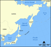
The
Sea of Okhotsk is a
marginal seaThe term marginal sea has differing meanings. In one sense the term is equivalent to territorial waters. In another sense the term indicates a partially enclosed sea adjacent to or widely open to the open ocean, but bounded by submarine ridges...
of the western
Pacific OceanThe Pacific Ocean is the largest of the Earth's oceanic divisions. It extends from the Arctic in the north to the Southern Ocean in the south, bounded by Asia and Australia in the west, and the Americas in the east.At 165.2 million square kilometres in area, this largest division of the World...
, lying between the
Kamchatka PeninsulaThe Kamchatka Peninsula is a peninsula in the Russian Far East, with an area of . It lies between the Pacific Ocean to the east and the Sea of Okhotsk to the west...
on the east, the
Kuril IslandsThe Kuril Islands , in Russia's Sakhalin Oblast region, form a volcanic archipelago that stretches approximately northeast from Hokkaidō, Japan, to Kamchatka, Russia, separating the Sea of Okhotsk from the North Pacific Ocean. There are 56 islands and many more minor rocks. It consists of Greater...
on the southeast, the
islandAn island or isle is any piece of sub-continental land that is surrounded by water. Very small islands such as emergent land features on atolls can be called islets, cays or keys. An island in a river or lake may be called an eyot , or holm...
of
Hokkaidō, formerly known as Ezo, Yezo, Yeso, or Yesso, is Japan's second largest island; it is also the largest and northernmost of Japan's 47 prefectural-level subdivisions. The Tsugaru Strait separates Hokkaido from Honshu, although the two islands are connected by the underwater railway Seikan Tunnel...
to the far south, the island of
SakhalinSakhalin or Saghalien, is a large island in the North Pacific, lying between 45°50' and 54°24' N.It is part of Russia, and is Russia's largest island, and is administered as part of Sakhalin Oblast...
along the west, and a long stretch of eastern
SiberiaSiberia is an extensive region constituting almost all of Northern Asia. Comprising the central and eastern portion of the Russian Federation, it was part of the Soviet Union from its beginning, as its predecessor states, the Tsardom of Russia and the Russian Empire, conquered it during the 16th...
n coast (including the
Shantar IslandsThe Shantar Islands are a group of fifteen islands that lie in Uda Bay, in the southwestern zone of the Sea of Okhotsk. These islands are located close to the shores of the Siberian mainland...
) along the west and north. The northeast corner is Shelikhov Gulf. It is named after
OkhotskOkhotsk is an urban locality and a seaport at the mouth of the Okhota River on the Sea of Okhotsk, in Okhotsky District, Khabarovsk Krai, Russia. Population: 4,470 ;...
, the first
RussiaRussia or , officially known as both Russia and the Russian Federation , is a country in northern Eurasia. It is a federal semi-presidential republic, comprising 83 federal subjects...
n settlement in the
Far EastRussian Far East is a term that refers to the Russian part of the Far East, i.e., extreme east parts of Russia, between Lake Baikal in Eastern Siberia and the Pacific Ocean...
.
Geography
The Sea of Okhotsk covers 611,000 sq.mi. (1,583,000 km
2), with a mean depth of 2,818 feet (859 metres). Its maximum depth is 11,063 feet (3,372 metres). It is connected to the
Sea of JapanThe Sea of Japan is a marginal sea of the western Pacific Ocean, between the Asian mainland, the Japanese archipelago and Sakhalin. It is bordered by Japan, North Korea, Russia and South Korea. Like the Mediterranean Sea, it has almost no tides due to its nearly complete enclosure from the Pacific...
on either side of Sakhalin: on the west through the
Sakhalin GulfSakhalin Gulf is a gulf in the Sea of Okhotsk between continental Russia and northern tip of the Sakhalin Island. The width of the gulf reaches up to 160 km...
and the Gulf of Tartary; on the south, through the
La Pérouse StraitLa Pérouse Strait is a strait dividing the southern part of the Russian island of Sakhalin from the northern part of the Japanese island of Hokkaidō, and connecting the Sea of Japan on the west with the Sea of Okhotsk on the east....
.
In
winterWinter is the coldest season of the year in temperate climates, between autumn and spring. At the winter solstice, the days are shortest and the nights are longest, with days lengthening as the season progresses after the solstice.-Meteorology:...
, navigation on the Sea of Okhotsk becomes difficult, or even impossible, due to the formation of large ice floes, because the large amount of freshwater from the Amur River lowers the
salinitySalinity is the saltiness or dissolved salt content of a body of water. It is a general term used to describe the levels of different salts such as sodium chloride, magnesium and calcium sulfates, and bicarbonates...
and raises the
freezing pointFreezing Point is a news journal in the People's Republic of China which has been the subject of controversy over its criticism of Communist Party officials and the sympathetic ear it lent to a Chinese historian who had criticized official history textbooks...
of the sea. The distribution and thickness of ice floes depends on many factors: the location, the time of year, water currents, and the sea temperatures.
With the exception of
Hokkaidō, formerly known as Ezo, Yezo, Yeso, or Yesso, is Japan's second largest island; it is also the largest and northernmost of Japan's 47 prefectural-level subdivisions. The Tsugaru Strait separates Hokkaido from Honshu, although the two islands are connected by the underwater railway Seikan Tunnel...
, one of the
JapanJapan is an island nation in East Asia. Located in the Pacific Ocean, it lies to the east of the Sea of Japan, China, North Korea, South Korea and Russia, stretching from the Sea of Okhotsk in the north to the East China Sea and Taiwan in the south...
ese
home islandsThe , which forms the country of Japan, extends roughly from northeast to southwest along the northeastern coast of the Eurasia mainland, washing upon the northwestern shores of the Pacific Ocean...
, the sea is surrounded on all sides by territory administered by the Russian Federation. For this reason, it is generally considered as being under Russian sovereignty.
Extent
The
International Hydrographic OrganizationThe International Hydrographic Organization is the inter-governmental organisation representing the hydrographic community. It enjoys observer status at the UN and is the recognised competent authority on hydrographic surveying and nautical charting...
defines the limits of the Sea of Okhotsk as follows:
On the Southwest. The Northeastern and Northern limits on the Japan Sea [In La Perouse StraitLa Pérouse Strait is a strait dividing the southern part of the Russian island of Sakhalin from the northern part of the Japanese island of Hokkaidō, and connecting the Sea of Japan on the west with the Sea of Okhotsk on the east....
(Sôya Kaikyô). A line joining Sôni Misakiis the northernmost point of the island of Hokkaidō, Japan. It is situated in Wakkanai, Sōya Subprefecture. The is at the cape, although the true northernmost point under Japanese control is a small deserted island called Bentenjima, 1 km northwest...
and Nishi Notoro Misaki (45°55'N). From Cape Tuik (51°45'N) to Cape Sushcheva].
On the Southeast. A line running from Nosyappu Saki (Cape Noshap, 43°23'N) in the Island of Hokusyû, formerly known as Ezo, Yezo, Yeso, or Yesso, is Japan's second largest island; it is also the largest and northernmost of Japan's 47 prefectural-level subdivisions. The Tsugaru Strait separates Hokkaido from Honshu, although the two islands are connected by the underwater railway Seikan Tunnel...
(Yezo) through the KurilThe Kuril Islands , in Russia's Sakhalin Oblast region, form a volcanic archipelago that stretches approximately northeast from Hokkaidō, Japan, to Kamchatka, Russia, separating the Sea of Okhotsk from the North Pacific Ocean. There are 56 islands and many more minor rocks. It consists of Greater...
or Tisima Islands to Cape LopatkaCape Lopatka is the southernmost point of Kamchatka Peninsula, Russia, with the rural locality of Semenovka at its southernmost point. Cape Lopatka lies about north of Shumshu, the northernmost island of the Kuril Islands...
(South point of KamchatkaThe Kamchatka Peninsula is a peninsula in the Russian Far East, with an area of . It lies between the Pacific Ocean to the east and the Sea of Okhotsk to the west...
) in such a way that all the narrow waters between Hokusyû and Kamchatka are included in the Sea of Okhotsk.
Islands
Some of the Islands limiting the Sea of Okhotsk from the south, like Hokkaidō and Sakhalin, are very large. Practically all islands in the Okhotsk Sea are either coastal islands or they belong to the
KurilThe Kuril Islands , in Russia's Sakhalin Oblast region, form a volcanic archipelago that stretches approximately northeast from Hokkaidō, Japan, to Kamchatka, Russia, separating the Sea of Okhotsk from the North Pacific Ocean. There are 56 islands and many more minor rocks. It consists of Greater...
island chain.
Ion IslandIony Island , or Jonas' Island, formerly Ostrov Svyatogo Iony , is a small island in the Sea of Okhotsk. It is 1.6 km in length and 850 m wide and it has a conical shape....
is the only island in the Sea of Okhotsk that is located in the open sea. The majority of the islands in the Okhotsk Sea are uninhabited, being an ideal breeding ground for seals and seabirds.
History
The Russian explorers
Ivan MoskvitinIvan Yuryevich Moskvitin was a Russian explorer, presumably a native of Moscow, who led a Russian reconnaissance party to the Pacific Ocean, becoming the first Russian to reach the Sea of Okhotsk....
and
Vassili PoyarkovVassili Danilovich Poyarkov was the first Russian explorer of the Amur region.The Russian expansion into Siberia began with the conquest of the Khanate of Sibir in 1582. By 1643 they reached the Pacific at Okhotsk...
were the first Europeans to visit the Sea of Okhotsk (and, probably, the island of
SakhalinSakhalin or Saghalien, is a large island in the North Pacific, lying between 45°50' and 54°24' N.It is part of Russia, and is Russia's largest island, and is administered as part of Sakhalin Oblast...
) in the 1640s.
The Dutch captain
Maarten Gerritsz VriesMaarten Gerritsz Vries, or Fries, also referred to as de Vries, was a 17th-century Dutch cartographer and explorer, the first Western European to leave an account of his visit to the Sea of Okhotsk and the island of Sakhalin.Not much is known about the life of de Vries...
in the
Breskens entered the Sea of Okhotsk from the south-east in 1643, and charted parts of the Sakhalin coast and Kurile Islands, but failed to realize that either Sakhalin or Hokkaido are islands.
The first and foremost Russian settlement on the shore was the port of
OkhotskOkhotsk is an urban locality and a seaport at the mouth of the Okhota River on the Sea of Okhotsk, in Okhotsky District, Khabarovsk Krai, Russia. Population: 4,470 ;...
, which relinquished commercial supremacy to Ayan in the 1840s. The
Russian-American CompanyThe Russian-American Company was a state-sponsored chartered company formed largely on the basis of the so-called Shelekhov-Golikov Company of Grigory Shelekhov and Ivan Larionovich Golikov The Russian-American Company (officially: Under His Imperial Majesty's Highest Protection (patronage)...
all but monopolized the commercial navigation of the sea in the first half of the 19th century.
The Second Kamchatka Expedition under
Vitus BeringVitus Jonassen Bering Vitus Jonassen Bering Vitus Jonassen Bering (also, less correNavy]], a captain-komandor known among the Russian sailors as Ivan Ivanovich. He is noted for being the first European to discover Alaska and its Aleutian Islands...
systematically mapped the entire coast of the sea, starting in 1733.
Jean-François de La PérouseJean François de Galaup, comte de Lapérouse was a French Navy officer and explorer whose expedition vanished in Oceania.-Early career:...
and
William Robert BroughtonWilliam Robert Broughton was a British naval officer in the late 18th century. As a Lieutenant in the Royal Navy, he commanded HMS Chatham as part of the Vancouver Expedition, a voyage of exploration through the Pacific Ocean led by Captain George Vancouver in the early 1790s.-With Vancouver:In...
were the first non-Russian European navigators known to have passed through these waters other than Maarten Gerritsz Vries. Ivan Krusenstern explored the eastern coast of the Sakhalin in 1805.
Mamiya Rinzōwas a Japanese explorer of the late Edo period.Mamiya was born in 1775 in Tsukuba District, Hitachi Province, in what is now Tsukubamirai, Ibaraki Prefecture. Later in his life he would become an undercover agent for the Tokugawa shogunate...
and
Gennady NevelskoyGennady Ivanovich Nevelskoy was a Russian navigator.In 1848 Nevelskoy led the expedition in the Russian Far East, exploring the area of the Sakhalin and the outlet of the Amur River. He proved that the Strait of Tartary was not a gulf, but indeed a strait, connected to Amur's estuary by a narrow...
determined that the Sakhalin was indeed an island separated from the mainland by a narrow strait. The first detailed summary of the
hydrologyHydrology is the study of the movement, distribution, and quality of water on Earth and other planets, including the hydrologic cycle, water resources and environmental watershed sustainability...
of the sea was prepared and published by
Stepan MakarovStepan Osipovich Makarov was a Ukrainian - born Russian vice-admiral, a highly accomplished and decorated commander of the Imperial Russian Navy, an oceanographer, awarded by the Russian Academy of Sciences, and author of several books. Makarov also designed a small number of ships...
in 1894.
During the
Cold WarThe Cold War was the continuing state from roughly 1946 to 1991 of political conflict, military tension, proxy wars, and economic competition between the Communist World—primarily the Soviet Union and its satellite states and allies—and the powers of the Western world, primarily the United States...
, the Sea of Okhotsk was the scene of several successful
U.S. NavyThe United States Navy is the naval warfare service branch of the United States Armed Forces and one of the seven uniformed services of the United States. The U.S. Navy is the largest in the world; its battle fleet tonnage is greater than that of the next 13 largest navies combined. The U.S...
operations (including
Operation Ivy BellsOperation Ivy Bells was a joint United States Navy, CIA and National Security Agency mission whose objective was to place wire taps on Soviet underwater communication lines during the Cold War.-History:...
) to tap
Soviet NavyThe Soviet Navy was the naval arm of the Soviet Armed Forces. Often referred to as the Red Fleet, the Soviet Navy would have played an instrumental role in a Warsaw Pact war with NATO, where it would have attempted to prevent naval convoys from bringing reinforcements across the Atlantic Ocean...
undersea communications cables. These operations were documented in the book
Blind Man's Bluff: The Untold Story of American Submarine EspionageBlind Man's Bluff: The Untold Story of American Submarine Espionage , published in 1998 by Sherry Sontag, Christopher Drew, and Annette Lawrence Drew, is a non-fiction book about U.S. Navy submarine operations during the Cold War...
. The sea (and surrounding area) were also the scene of the
Soviet PVO StranyThe Soviet Air Defence Forces was the air defense branch of the Soviet Armed Forces. It continued being a service branch of the Armed Forces of the Russian Federation from 1991 to 1998. Unlike Western air defense forces, V-PVO was a branch of the military unto itself, separate from the Soviet...
attack on
Korean Air Flight 007Korean Air Lines Flight 007 was a Korean Air Lines civilian airliner that was shot down by Soviet interceptors on 1 September 1983, over the Sea of Japan, near Moneron Island just west of Sakhalin island...
in 1983. The Soviet Pacific Fleet used the Sea as a ballistic missile submarine
bastionA bastion in naval strategy is a heavily-defended area of water in which friendly naval forces can operate safely. Typically, that area will be partially enclosed by friendly shoreline, defended by naval mines, monitored by sensors, and heavily patrolled by surface, submarine, and air forces.-...
, a strategy that
RussiaRussia or , officially known as both Russia and the Russian Federation , is a country in northern Eurasia. It is a federal semi-presidential republic, comprising 83 federal subjects...
continues.
In the
Japanese languageis a language spoken by over 130 million people in Japan and in Japanese emigrant communities. It is a member of the Japonic language family, which has a number of proposed relationships with other languages, none of which has gained wide acceptance among historical linguists .Japanese is an...
, the sea has no traditional Japanese name despite its close location to the Japanese territories and is called
Ohōtsuku-kai (オホーツク海), which is a transcription of the Russian name. Additionally,
Abashiri Subprefectureis a subprefecture of Hokkaido, Japan. It was renamed from the earlier Abashiri Subprefecture on April 1, 2010. Abashiri Subprefecture was established in 1897.-Naming:Abashiri Prefecture was named after the subprefectural office in Abashiri...
, the part of Hokkaidō which faces the sea, is often called the , named after the sea.
The Sea of Okhotsk was a hotbed for
whalingWhaling is the hunting of whales mainly for meat and oil. Its earliest forms date to at least 3000 BC. Various coastal communities have long histories of sustenance whaling and harvesting beached whales...
in the mid-19th century. Beginning in 1845, American whaleships began hunting
right whaleRight whales are three species of large baleen whales consisting of two genera in the family Balaenidae of order Cetacea. Their bodies are very dark gray or black and rotund....
s in the southeastern part of the Sea of Okhotsk near the Kurile Islands. The first bowheads were caught in 1847; from 1849 bowheads dominated the catch. Between 1850 and 1853 the majority of the fleet focused their efforts on bowheads in the Bering Strait region. Following poor catches there, whaleships began shifting their attention to the stock of
bowhead whaleThe bowhead whale is a baleen whale of the right whale family Balaenidae in suborder Mysticeti. A stocky dark-colored whale without a dorsal fin, it can grow to in length. This thick-bodied species can weigh to , second only to the blue whale, although the bowhead's maximum length is less than...
s in the Sea of Okhotsk. In 1854 alone some 160 whaleships visited the region; the following year more than 130 ships. The next year, 1856, nearly 150 ships sailed to the Okhotsk. By 1857, the number of ships had declined to a little over 100. With declining catches from 1858 to 1860 the fleet shifted its focus back to the Bering Strait region. Many of the ships converged on the Shantar Islands, anchoring within the archipelago's many sheltered bays. On July 28, 1854 the New Bedford ship
Isabella reported ninety-four ships in sight from her deck. A few days later the
Lexington, of Nantucket, reported one hundred whaleboats were about chasing whales. Ships continued to hunt whales in the Sea of Okhotsk until the early 20th century.
Oil reserves
Twenty-nine zones of possible oil and gas accumulation have been identified on the Sea of Okhotsk shelf which runs along the coast. Total reserves are estimated at 3.5 billion tons of equivalent fuel, including 1.2 billion tons of oil and 1.5 billion cubic meters of gas.
Notable seaports
.jpg)
- Abashiri, Hokkaidō
, formerly known as Ezo, Yezo, Yeso, or Yesso, is Japan's second largest island; it is also the largest and northernmost of Japan's 47 prefectural-level subdivisions. The Tsugaru Strait separates Hokkaido from Honshu, although the two islands are connected by the underwater railway Seikan Tunnel...
, JapanJapan is an island nation in East Asia. Located in the Pacific Ocean, it lies to the east of the Sea of Japan, China, North Korea, South Korea and Russia, stretching from the Sea of Okhotsk in the north to the East China Sea and Taiwan in the south...
- Magadan
Magadan is a port town on the Sea of Okhotsk and gateway to the Kolyma region. It is the administrative center of Magadan Oblast , in the Russian Far East. Founded in 1929 on the site of an earlier settlement from the 1920s, it was granted the status of town in 1939...
, MagadanMagadan Oblast is a federal subject of Russia in the Far Eastern Federal District. Its administrative center is the city of Magadan....
, RussiaRussia or , officially known as both Russia and the Russian Federation , is a country in northern Eurasia. It is a federal semi-presidential republic, comprising 83 federal subjects...
- Monbetsu
is the name of several places in Japan:* Monbetsu, Hokkaidō, a city in Abashiri Subprefecture, Hokkaidō* Monbetsu District, Hokkaidō, a district of Abashiri Subprefecture, Hokkaidō...
, Hokkaidō, formerly known as Ezo, Yezo, Yeso, or Yesso, is Japan's second largest island; it is also the largest and northernmost of Japan's 47 prefectural-level subdivisions. The Tsugaru Strait separates Hokkaido from Honshu, although the two islands are connected by the underwater railway Seikan Tunnel...
, JapanJapan is an island nation in East Asia. Located in the Pacific Ocean, it lies to the east of the Sea of Japan, China, North Korea, South Korea and Russia, stretching from the Sea of Okhotsk in the north to the East China Sea and Taiwan in the south...
- Palana
Palana is an urban locality and the administrative center of Koryak Okrug of Kamchatka Krai, Russia. It is located on the west coast of the Kamchatka Peninsula on the right bank of the Palana River, within from the Sea of Okhotsk. Population: Administratively, Palana is subordinated to Tigilsky...
, Kamchatka, RussiaRussia or , officially known as both Russia and the Russian Federation , is a country in northern Eurasia. It is a federal semi-presidential republic, comprising 83 federal subjects...
- Wakkanai, Hokkaidō
, formerly known as Ezo, Yezo, Yeso, or Yesso, is Japan's second largest island; it is also the largest and northernmost of Japan's 47 prefectural-level subdivisions. The Tsugaru Strait separates Hokkaido from Honshu, although the two islands are connected by the underwater railway Seikan Tunnel...
, JapanJapan is an island nation in East Asia. Located in the Pacific Ocean, it lies to the east of the Sea of Japan, China, North Korea, South Korea and Russia, stretching from the Sea of Okhotsk in the north to the East China Sea and Taiwan in the south...
The source of this article is
wikipedia, the free encyclopedia. The text of this article is licensed under the
GFDL.