

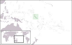
Gilbert Islands
Encyclopedia
The Gilbert Islands are a chain of sixteen atoll
s and coral islands in the Pacific Ocean
. They are the main part of Republic of Kiribati
("Kiribati" is the rendition of "Gilberts" in Gilbertese) and include Tarawa, the site of the country's capital and residence of almost half of the population.
serves as the dividing line between the northern Gilbert Islands and the southern Gilbert Islands. The International Hydrographic Organization
(IHO) considers the Gilberts wholly within the South Pacific Ocean, however.
Another method of grouping the Gilbert Islands is by former administrative districts, the Northern, Central, and Southern Gilberts (Tarawa once was a separate district as well).
A group of the southern Gilberts is called the Kingsmill Group, a name that in the 19th century applied to all of the Gilberts.
The Gilberts form a continuous chain of seamount
s with the Ratak Chain
of the Marshall Islands
to the north.
, Makin
, Marakei
, Abaiang
(literally northland) and Tarawa. They have unique tonal accents with differences particularly noted amongst Butaritari
and Makin
inhabitants.
The northern Gilberts have a greater mean rainfall in comparison to the southern and central Gilberts allowing cultivation of a wider crop range. Butaritari and Makin supply most of the bananas sold in Kiribati. The cultivation of taro or babai (C. esculenta) has been historically easier in the northern Gilberts due to a higher water table and regular rainfall.
, Abemama
, Kuria
and Aranuka
. However, the latter three are considered the main islands that have unique historical and cultural characteristics which distinguish the Central Gilberts from the north and south.
The Central Gilberts as well as Butaritari
are the only regions which have had an organised and widely recognised aristocracy and royal lineage. Tembinok'
, the last king of Abemama
, Kuria
and Aranuka
died in the early part of the 20th century.
, South and North Tabiteuea
, Beru
, Nikunau
, Onotoa
, Tamana
and the most southerly island of Arorae
.
ns for several millennia (at least 2.000 years, probably 3.000). After Pedro Fernandes de Queirós
in 1606 (he discovered the Makin/Butaritari group), the first European explorers to reach the islands were 1788 Captain Thomas Gilbert
in the Charlotte
and Captain John Marshall
in the Scarborough
. Messrs. Gilbert and Marshall crossed through Abemama
, Kuria, Aranuka
, Tarawa
, Abaiang
, Butaritari
, and Makin
without attempting to land on shore.
 In 1820, the islands were named îles Gilbert (in French) by von Krusenstern
, an Estonia
n admiral of the Czar after the British captain, Thomas Gilbert
, together with the neighbouring îles Marshall.
Two ships of the United States Exploring Expedition, and , under the command of Captain Hudson, visited many of the Gilbert Islands (then called the Kingsmill Islands or Kingsmill Group in English). While in the Gilberts, considerable time was devoted to mapping and charting reef
s and anchorages.
was first proclaimed over the Gilberts by Captain Davis of on 27 May 1892. In 1915, the Gilbert and Ellice Islands
were proclaimed a colony
of the British Empire
.
, the Carolines
, and the Marianas
.
At the outbreak of the war, about 78% of the native population were said to be Christians. This group was divided mainly into two denominations: Congregationalist
s (43%); and Roman Catholics (35%). The rest of the population were largely semi-pagan agnostics; they did not adhere to the Christian faith, nor did they retain much of their beliefs in their own ancient gods.
Native diet during this time consisted mainly of fish, coconuts, pandanus
fruit, babai (swamp taro
), chicken, and some pork. Housing for Europeans employed in the island was simple. Their houses were constructed of both European and native materials and were generally of the bungalow type. There was no tourism.
from the deposits on Ocean Island
and Fanning Island. In addition, coconut palm
s were cultivated on some of the islands. All labor was supervised by the British and every effort was made to see that the wages and living conditions were fair and adequate. Sanitary inspections by the British did much to improve the general living conditions on most of the islands.
With the availability of European-style medical care life improved. The Phoenix Islands Settlement Scheme
sought to provide an outlet through the development of three uninhabited atolls in the Phoenix Islands
and was the last attempt at human colonization within the British Empire.
into Gilbertese, and also wrote hymn
s for the Gilbertese language.
"The Gilbert (and Ellice) Islanders had a strong set of beliefs of their own, pre the Christian missionaries; they had a strong foundation myth, involving trees and the two genders. Their ancestors, they said, had been white skinned and red haired and came from elsewhere, perhaps the West(possibly coinciding with the outward spread of Homo sapiens from Africa and elsewhere). As might be expected, they gave power to the natural forces and gave them names and godly characteristics (sun, moon, etc.) but believed in one spirit god, a bit similar to the god of Genesis, in that he/she seemed to have power over dark and light and so on, and was pretty much invisible. They had a strong belief in behaving properly to their ancestors, and especially their parents, and had well-developed community rules for courtesy to others. Read A Pattern of Islands, by Arthur Grimble, who worked in these islands and on Banaba, for the Colonial Administration, from just before the First World War to the mid thirties, or thereabouts. It is a remarkable, informative, funny and warm hearted account of these people, their religion. Other religions on the islands figure slightly, and there are remarkable stories of adventures, bravery, political machinations,etc.. Probably out of print, but second hand copies are available I think, I have two, and the illustrations are delightful".Joanna Gordon Clark
, the Japanese invaded the Gilbert Islands, occupying them by December 10.
On 17 August 1942, 221 U.S. Marines
of the 2nd Marine Raider Battalion
raided Makin
from two submarines. The raid was intended by the Americans to confuse the Japanese about US intentions in the Pacific. It is instead believed to have alerted the Japanese to the strategic importance of the Gilbert Islands and led to their reinforcement and fortification.
Tarawa and Abemama
were occupied in force by the Japanese in September 1942 and during the next year garrisons were built up on Betio
(Tarawa Atoll), and Butaritari
(Makin Atoll). Only nominal forces were placed on other islands in the Gilberts.
On 20 November 1943, the United States Army
and U.S. 2nd Marine Division landed on Makin and Tarawa, initiating the battles of Makin
and Tarawa
, in which the Japanese were defeated. The Gilbert Islands were then used to support the invasion of the Marshall Islands
in February 1944.
became autonomous in 1971. From 1976 to 1978, the Ellices were separated, and the Gilberts became the Gilbert Islands colony, which issued stamps under that name. In 1979, the Gilberts opted for independence, becoming the independent nation of Kiribati
. The Ellices become the independent nation of Tuvalu
.
Atoll
An atoll is a coral island that encircles a lagoon partially or completely.- Usage :The word atoll comes from the Dhivehi word atholhu OED...
s and coral islands in the Pacific Ocean
Pacific Ocean
The Pacific Ocean is the largest of the Earth's oceanic divisions. It extends from the Arctic in the north to the Southern Ocean in the south, bounded by Asia and Australia in the west, and the Americas in the east.At 165.2 million square kilometres in area, this largest division of the World...
. They are the main part of Republic of Kiribati
Kiribati
Kiribati , officially the Republic of Kiribati, is an island nation located in the central tropical Pacific Ocean. The permanent population exceeds just over 100,000 , and is composed of 32 atolls and one raised coral island, dispersed over 3.5 million square kilometres, straddling the...
("Kiribati" is the rendition of "Gilberts" in Gilbertese) and include Tarawa, the site of the country's capital and residence of almost half of the population.
Geography
The atolls and islands of the Gilbert Islands are arranged in an approximate north-to-south line. In a geographical sense, the equatorEquator
An equator is the intersection of a sphere's surface with the plane perpendicular to the sphere's axis of rotation and containing the sphere's center of mass....
serves as the dividing line between the northern Gilbert Islands and the southern Gilbert Islands. The International Hydrographic Organization
International Hydrographic Organization
The International Hydrographic Organization is the inter-governmental organisation representing the hydrographic community. It enjoys observer status at the UN and is the recognised competent authority on hydrographic surveying and nautical charting...
(IHO) considers the Gilberts wholly within the South Pacific Ocean, however.
Another method of grouping the Gilbert Islands is by former administrative districts, the Northern, Central, and Southern Gilberts (Tarawa once was a separate district as well).
A group of the southern Gilberts is called the Kingsmill Group, a name that in the 19th century applied to all of the Gilberts.
The Gilberts form a continuous chain of seamount
Seamount
A seamount is a mountain rising from the ocean seafloor that does not reach to the water's surface , and thus is not an island. These are typically formed from extinct volcanoes, that rise abruptly and are usually found rising from a seafloor of depth. They are defined by oceanographers as...
s with the Ratak Chain
Ratak Chain
The Ratak Chain is a chain of islands within the island nation of the Marshall Islands. Ratak means "sunrise". It lies just to the east of the country's other main island chain, the Ralik Chain...
of the Marshall Islands
Marshall Islands
The Republic of the Marshall Islands , , is a Micronesian nation of atolls and islands in the middle of the Pacific Ocean, just west of the International Date Line and just north of the Equator. As of July 2011 the population was 67,182...
to the north.
Islands of the Gilberts
In official north-south order (grouped by former administrative districts), the islands and atolls are: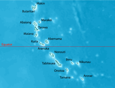 |
||||||||||
|---|---|---|---|---|---|---|---|---|---|---|
| Atoll/Island | Mainvillage | Land area | Lagoon Lagoon A lagoon is a body of shallow sea water or brackish water separated from the sea by some form of barrier. The EU's habitat directive defines lagoons as "expanses of shallow coastal salt water, of varying salinity or water volume, wholly or partially separated from the sea by sand banks or shingle,... area |
Pop.c. Census A census is the procedure of systematically acquiring and recording information about the members of a given population. It is a regularly occurring and official count of a particular population. The term is used mostly in connection with national population and housing censuses; other common... 2005 |
Min.numberof islets | Vill-ages | Location Geographic coordinate system A geographic coordinate system is a coordinate system that enables every location on the Earth to be specified by a set of numbers. The coordinates are often chosen such that one of the numbers represent vertical position, and two or three of the numbers represent horizontal position... |
|||
| km² | sq mi | km² | sq mi | |||||||
| former district of the northern Gilberts | ||||||||||
| Makin Makin (islands) Makin is the name of a chain of islands located in the Pacific Ocean island nation of Kiribati, specifically in the Gilbert Islands.-Geography:... |
Makin | 6.7 | 2.6 | — | — | 2,385 | 5 | 2 | 3°23′N 173°00′E | |
| Butaritari Butaritari Butaritari is an atoll located in the Pacific Ocean island nation of Kiribati.-Geography:... |
Temanokunuea | 13.6 | 5.3 | 191.7 | 74 | 3,280 | 11 | 11 | 3°09′N 172°50′E | |
| Marakei Marakei Marakei is a small atoll in the North Gilbert Islands. The central lagoon consists of numerous deep basins and surrounded by two large islands which are separated by two narrow channels. The atoll covers an area of 13.5 km².- Geography :... |
Rawannawi Rawannawi Rawannawi is a settlement at the northern tip of Marakei, Kiribati. It is located about from Tarawa.- Airport :Rawannawi is very close to Marakei Airport, which is connected with Abaiang, Butaritari, and the international airport at Tarawa.... |
13.5 | 5.2 | 19.6 | 7.6 | 2,741 | 1 | 8 | 2°00′N 173°17′E | |
| Abaiang Abaiang Abaiang, also spelled Apaiang, sometimes called Apiaia, and formerly named Charlotte Island, Matthews or Six Isles, is a coral atoll of Kiribati, located in the west-central Pacific Ocean.-Geography:... |
Tuarabu | 16 | 6.2 | 232.5 | 89.8 | 5,502 | 4-20 | 18 | 1°50′N 172°57′E | |
| Tarawa | Bairiki | 31.9 | 12.3 | 343.6 | 132.7 | 45,989 | 9+ | 30 | 1°26′N 173°00′E | |
| former district of the Central Gilberts | ||||||||||
| Maiana Maiana Maiana is a district of Kiribati and an atoll in the North Gilbert Islands. The north and eastern sides of the atoll are a single island whilst the western edge consists of submerged reefs, all surrounding a lagoon... |
Tebwangetua | 15.9 | 6.1 | 98.4 | 38 | 1,908 | 9 | 12 | 0°55′N 173°00′E | |
| Abemama Abemama Abemama is an atoll in the central part of the Kiribati Group located 152 kilometres southeast of Tarawa and just north of the Equator.- Geography :... |
Kariatebike | 27.8 | 10.7 | 132.4 | 51.1 | 3,404 | 8 | 12 | 0°24′N 173°50′E | |
| Kuria Kuria (islands) Kuria is a the name of a pair of islands in the North Gilbert Islands in the Pacific Ocean. They are located northwest of Aranuka .... |
Tabontebike | 12.3 | 4.7 | — | — | 1,082 | 2 | 6 | 0°13′N 173°24′E | |
| Aranuka Aranuka Aranuka is an atoll of Kiribati, located just north of the equator, in the Gilbert Islands... |
Takaeang | 15.5 | 6 | 19.4 | 7.5 | 1,158 | 4 | 3 | 0°09′N 173°35′E | |
| Nonouti Nonouti Nonouti is an atoll and district of Kiribati. The atoll is located in the South Gilbert Islands, 38 km north of Tabiteuea, and 250 km south of Tarawa. The eastern side of the atoll is the primary permanent landmass. There is an islet on the northwest side of the atoll called Noumatong. Noumatong... 1) |
Teuabu | 29.2 | 11.3 | 370.4 | 143 | 3,179 | 12 | 9 | 0°40′S 174°20′E | |
| former district of the Southern Gilberts | ||||||||||
| Tabiteuea Tabiteuea Tabiteuea is an atoll in the Gilbert Islands, Kiribati, south of Tarawa. The atoll consists of two main islands: Eanikai in the north, Nuguti in the south, and several smaller islets in between along the eastern rim of the atoll. The atoll has a total land area of 38 km², while the lagoon measures... 1) |
Buariki Buariki Buariki is the largest island in the Aranuka atoll of the Gilbert Islands in the Republic of Kiribati. It is one of two large islands which help form the triangle shape of the atoll with Buariki forming the base.-Air transportation:... |
38 | 14.7 | 365.2 | 141 | 4,898 | 2+ | 18 | 1°20′S 174°50′E | |
| Beru Beru Island Beru Island is an island located in the Kingsmill Group of the South Gilbert Islands in the Pacific Ocean and is part of the Republic of Kiribati. Beru was previously known as Eliza, Francis Island, Maria, Peroat, Peru Island or Sunday.- Geography :... 1) |
Taubukinberu | 14.7 | 5.7 | 38.9 | 15 | 2,169 | 1 | 9 | 1°20′S 175°59′E | |
| Nikunau Nikunau Nikunau is a low coral island located in the Gilbert Islands and forms a council district of the Republic of Kiribati. The island consists of two parts which are joined by an isthmus about 150 m wide.... 1) |
Rungata Rungata Rungata is a settlement in Kiribati. It is located on the fairly remote atoll of Nikunau; the nearest locations, to the east, are Manriki and Nikumanu, both of which are between two and three nautical miles away.... |
18.2 | 7 | — | — | 1,912 | 1 | 6 | 1°21′S 176°28′E | |
| Onotoa Onotoa Onotoa is an atoll and district of Kiribati. It is situated in the Gilbert Islands in the Pacific Ocean, 65 km from Tamana, the smallest island in the Gilberts.... 1) |
Buariki | 13.5 | 5.2 | 54.4 | 21 | 1,644 | 30 | 7 | 1°52′S 175°33′E | |
| Tamana | Bakaka | 4.8 | 1.9 | — | — | 875 | 1 | 3 | 2°30′S 175°58′E | |
| Arorae Arorae Arorae is an atoll in Kiribati located near the equator.- Geography :The atoll's area is 9,5 km² and has a population of about 1,225 inhabitants most of which are Protestants. The largest villages on the atoll are Roreti, Tamaroa and Taribo.The atoll is a low and flat coralline island with an... |
Roreti | 9.5 | 3.7 | — | — | 1,256 | 1 | 2 | 2°38′S 176°49′E | |
| Gilbert Islands | Tarawa | 281.1 | 108.5 | 1866.5 | 720.7 | 83,382 | 117+ | 156 | 3°23'N to 2°38S172°50' to 176°49'E | |
| 1) part of Kingsmill Group proper | ||||||||||
Northern Gilberts
The Northern Gilberts (mweang) geographically and traditionally encompass ButaritariButaritari
Butaritari is an atoll located in the Pacific Ocean island nation of Kiribati.-Geography:...
, Makin
Makin (islands)
Makin is the name of a chain of islands located in the Pacific Ocean island nation of Kiribati, specifically in the Gilbert Islands.-Geography:...
, Marakei
Marakei
Marakei is a small atoll in the North Gilbert Islands. The central lagoon consists of numerous deep basins and surrounded by two large islands which are separated by two narrow channels. The atoll covers an area of 13.5 km².- Geography :...
, Abaiang
Abaiang
Abaiang, also spelled Apaiang, sometimes called Apiaia, and formerly named Charlotte Island, Matthews or Six Isles, is a coral atoll of Kiribati, located in the west-central Pacific Ocean.-Geography:...
(literally northland) and Tarawa. They have unique tonal accents with differences particularly noted amongst Butaritari
Butaritari
Butaritari is an atoll located in the Pacific Ocean island nation of Kiribati.-Geography:...
and Makin
Makin (islands)
Makin is the name of a chain of islands located in the Pacific Ocean island nation of Kiribati, specifically in the Gilbert Islands.-Geography:...
inhabitants.
The northern Gilberts have a greater mean rainfall in comparison to the southern and central Gilberts allowing cultivation of a wider crop range. Butaritari and Makin supply most of the bananas sold in Kiribati. The cultivation of taro or babai (C. esculenta) has been historically easier in the northern Gilberts due to a higher water table and regular rainfall.
Central Gilberts
The Central Gilberts or nuka have traditionally included MaianaMaiana
Maiana is a district of Kiribati and an atoll in the North Gilbert Islands. The north and eastern sides of the atoll are a single island whilst the western edge consists of submerged reefs, all surrounding a lagoon...
, Abemama
Abemama
Abemama is an atoll in the central part of the Kiribati Group located 152 kilometres southeast of Tarawa and just north of the Equator.- Geography :...
, Kuria
Kuria (islands)
Kuria is a the name of a pair of islands in the North Gilbert Islands in the Pacific Ocean. They are located northwest of Aranuka ....
and Aranuka
Aranuka
Aranuka is an atoll of Kiribati, located just north of the equator, in the Gilbert Islands...
. However, the latter three are considered the main islands that have unique historical and cultural characteristics which distinguish the Central Gilberts from the north and south.
The Central Gilberts as well as Butaritari
Butaritari
Butaritari is an atoll located in the Pacific Ocean island nation of Kiribati.-Geography:...
are the only regions which have had an organised and widely recognised aristocracy and royal lineage. Tembinok'
Tembinok'
Tembinok’, or Tem Binoka, was the ruler of Abemama, Aranuka and Kuria, in the Gilbert Islands, during the late 19th century. Tembinok’'s grandfather, Teñkoruti , was the ruler of a village on Abemama, which was then experiencing devastating feuds...
, the last king of Abemama
Abemama
Abemama is an atoll in the central part of the Kiribati Group located 152 kilometres southeast of Tarawa and just north of the Equator.- Geography :...
, Kuria
Kuria (islands)
Kuria is a the name of a pair of islands in the North Gilbert Islands in the Pacific Ocean. They are located northwest of Aranuka ....
and Aranuka
Aranuka
Aranuka is an atoll of Kiribati, located just north of the equator, in the Gilbert Islands...
died in the early part of the 20th century.
Southern Gilberts
The Southern Gilberts include the atolls of NonoutiNonouti
Nonouti is an atoll and district of Kiribati. The atoll is located in the South Gilbert Islands, 38 km north of Tabiteuea, and 250 km south of Tarawa. The eastern side of the atoll is the primary permanent landmass. There is an islet on the northwest side of the atoll called Noumatong. Noumatong...
, South and North Tabiteuea
Tabiteuea
Tabiteuea is an atoll in the Gilbert Islands, Kiribati, south of Tarawa. The atoll consists of two main islands: Eanikai in the north, Nuguti in the south, and several smaller islets in between along the eastern rim of the atoll. The atoll has a total land area of 38 km², while the lagoon measures...
, Beru
Beru
BERU Group is a listed public company since October 1997. The company is the leading manufacturer of diesel cold start systems with an estimated worldwide market share of 40% for glow plugs. In the field of ignition technology for petrol engines, BERU is one of the four major manufacturers in...
, Nikunau
Nikunau
Nikunau is a low coral island located in the Gilbert Islands and forms a council district of the Republic of Kiribati. The island consists of two parts which are joined by an isthmus about 150 m wide....
, Onotoa
Onotoa
Onotoa is an atoll and district of Kiribati. It is situated in the Gilbert Islands in the Pacific Ocean, 65 km from Tamana, the smallest island in the Gilberts....
, Tamana
Tamana
Tamana is the smallest island in the Gilbert Islands. It is accessible both by boat and by air with Air Kiribati and Coral Sun Airways -References:* from the Navy Art Gallery...
and the most southerly island of Arorae
Arorae
Arorae is an atoll in Kiribati located near the equator.- Geography :The atoll's area is 9,5 km² and has a population of about 1,225 inhabitants most of which are Protestants. The largest villages on the atoll are Roreti, Tamaroa and Taribo.The atoll is a low and flat coralline island with an...
.
Prehistory and discovery by Europeans
Prior to the Gilberts' discovery by Europeans, the islands had been inhabited by MicronesiaMicronesia
Micronesia is a subregion of Oceania, comprising thousands of small islands in the western Pacific Ocean. It is distinct from Melanesia to the south, and Polynesia to the east. The Philippines lie to the west, and Indonesia to the southwest....
ns for several millennia (at least 2.000 years, probably 3.000). After Pedro Fernandes de Queirós
Pedro Fernandes de Queirós
Pedro Fernandes de Queirós , was a Portuguese navigator best known for his involvement with Spanish voyages of discovery in the Pacific Ocean, in particular the 1595-1596 voyage of Alvaro de Mendaña de Neira, and for leading a 1605-1606 expedition which crossed the Pacific in search of Terra...
in 1606 (he discovered the Makin/Butaritari group), the first European explorers to reach the islands were 1788 Captain Thomas Gilbert
Thomas Gilbert (captain)
Thomas Gilbert was an 18th century British mariner.Thomas Gilbert and John Marshall were the captains of two East India Company vessels, the Charlotte and the Scarborough, returning from carrying convicts to Botany Bay in 1788, when they sailed through the Gilbert Islands and described Aranuka,...
in the Charlotte
Charlotte (ship)
The Charlotte was a First Fleet transport ship of 335 tons, built on the River Thames in 1787. She was a light sailer, and had to be towed down the English Channel for the first few days of the voyage...
and Captain John Marshall
John Marshall (British captain)
Captain John Marshall was born in Ramsgate, Kent, England on 15 February 1748. Having been bound apprentice at the age of ten he spent his life at sea...
in the Scarborough
Scarborough (ship)
'Scarborough' was a transport ship of 430 tons, built at Scarborough in 1782. She formed part of the First Fleet, which commenced European settlement of Australia in 1788....
. Messrs. Gilbert and Marshall crossed through Abemama
Abemama
Abemama is an atoll in the central part of the Kiribati Group located 152 kilometres southeast of Tarawa and just north of the Equator.- Geography :...
, Kuria, Aranuka
Aranuka
Aranuka is an atoll of Kiribati, located just north of the equator, in the Gilbert Islands...
, Tarawa
Tarawa Atoll
Tarawa is an atoll in the central Pacific Ocean, previously the capital of the former British colony of the Gilbert and Ellice Islands. It is the location of the capital of the Republic of Kiribati, South Tarawa...
, Abaiang
Abaiang
Abaiang, also spelled Apaiang, sometimes called Apiaia, and formerly named Charlotte Island, Matthews or Six Isles, is a coral atoll of Kiribati, located in the west-central Pacific Ocean.-Geography:...
, Butaritari
Butaritari
Butaritari is an atoll located in the Pacific Ocean island nation of Kiribati.-Geography:...
, and Makin
Makin (islands)
Makin is the name of a chain of islands located in the Pacific Ocean island nation of Kiribati, specifically in the Gilbert Islands.-Geography:...
without attempting to land on shore.
Further exploration
Adam Johann von Krusenstern
Adam Johann Ritter von Krusenstern , was an admiral and explorer, who led the first Russian circumnavigation of the globe.- Life :...
, an Estonia
Estonia
Estonia , officially the Republic of Estonia , is a state in the Baltic region of Northern Europe. It is bordered to the north by the Gulf of Finland, to the west by the Baltic Sea, to the south by Latvia , and to the east by Lake Peipsi and the Russian Federation . Across the Baltic Sea lies...
n admiral of the Czar after the British captain, Thomas Gilbert
Thomas Gilbert (captain)
Thomas Gilbert was an 18th century British mariner.Thomas Gilbert and John Marshall were the captains of two East India Company vessels, the Charlotte and the Scarborough, returning from carrying convicts to Botany Bay in 1788, when they sailed through the Gilbert Islands and described Aranuka,...
, together with the neighbouring îles Marshall.
Two ships of the United States Exploring Expedition, and , under the command of Captain Hudson, visited many of the Gilbert Islands (then called the Kingsmill Islands or Kingsmill Group in English). While in the Gilberts, considerable time was devoted to mapping and charting reef
Reef
In nautical terminology, a reef is a rock, sandbar, or other feature lying beneath the surface of the water ....
s and anchorages.
Colonial rule
A British protectorateProtectorate
In history, the term protectorate has two different meanings. In its earliest inception, which has been adopted by modern international law, it is an autonomous territory that is protected diplomatically or militarily against third parties by a stronger state or entity...
was first proclaimed over the Gilberts by Captain Davis of on 27 May 1892. In 1915, the Gilbert and Ellice Islands
Gilbert and Ellice Islands
The Gilbert and Ellice Islands were a British protectorate from 1892 and colony from 1916 until 1 January 1976, when the islands were divided into two different colonies which became independent nations shortly after...
were proclaimed a colony
Colony
In politics and history, a colony is a territory under the immediate political control of a state. For colonies in antiquity, city-states would often found their own colonies. Some colonies were historically countries, while others were territories without definite statehood from their inception....
of the British Empire
British Empire
The British Empire comprised the dominions, colonies, protectorates, mandates and other territories ruled or administered by the United Kingdom. It originated with the overseas colonies and trading posts established by England in the late 16th and early 17th centuries. At its height, it was the...
.
Population
The natives of the Gilbert Islands are Micronesian, similar in many respects to the natives of the MarshallsMarshall Islands
The Republic of the Marshall Islands , , is a Micronesian nation of atolls and islands in the middle of the Pacific Ocean, just west of the International Date Line and just north of the Equator. As of July 2011 the population was 67,182...
, the Carolines
Caroline Islands
The Caroline Islands are a widely scattered archipelago of tiny islands in the western Pacific Ocean, to the north of New Guinea. Politically they are divided between the Federated States of Micronesia in the eastern part of the group, and Palau at the extreme western end...
, and the Marianas
Mariana Islands
The Mariana Islands are an arc-shaped archipelago made up by the summits of 15 volcanic mountains in the north-western Pacific Ocean between the 12th and 21st parallels north and along the 145th meridian east...
.
At the outbreak of the war, about 78% of the native population were said to be Christians. This group was divided mainly into two denominations: Congregationalist
Congregational church
Congregational churches are Protestant Christian churches practicing Congregationalist church governance, in which each congregation independently and autonomously runs its own affairs....
s (43%); and Roman Catholics (35%). The rest of the population were largely semi-pagan agnostics; they did not adhere to the Christian faith, nor did they retain much of their beliefs in their own ancient gods.
Native diet during this time consisted mainly of fish, coconuts, pandanus
Pandanus
Pandanus is a genus of monocots with about 600 known species. They are numerous palmlike dioecious trees and shrubs native of the Old World tropics and subtropics. They are classified in the order Pandanales, family Pandanaceae.-Overview:...
fruit, babai (swamp taro
Taro
Taro is a common name for the corms and tubers of several plants in the family Araceae . Of these, Colocasia esculenta is the most widely cultivated, and is the subject of this article. More specifically, this article describes the 'dasheen' form of taro; another variety is called eddoe.Taro is...
), chicken, and some pork. Housing for Europeans employed in the island was simple. Their houses were constructed of both European and native materials and were generally of the bungalow type. There was no tourism.
Economy
The principal industry found in the Gilberts was the production of phosphatePhosphate
A phosphate, an inorganic chemical, is a salt of phosphoric acid. In organic chemistry, a phosphate, or organophosphate, is an ester of phosphoric acid. Organic phosphates are important in biochemistry and biogeochemistry or ecology. Inorganic phosphates are mined to obtain phosphorus for use in...
from the deposits on Ocean Island
Banaba Island
Banaba Island , an island in the Pacific Ocean, is a solitary raised coral island west of the Gilbert Island chain and 300 km east of Nauru. It is part of the Republic of Kiribati. It has an area of 6.5 km², and the highest point on the island is also the highest point in Kiribati, at 81...
and Fanning Island. In addition, coconut palm
Coconut
The coconut palm, Cocos nucifera, is a member of the family Arecaceae . It is the only accepted species in the genus Cocos. The term coconut can refer to the entire coconut palm, the seed, or the fruit, which is not a botanical nut. The spelling cocoanut is an old-fashioned form of the word...
s were cultivated on some of the islands. All labor was supervised by the British and every effort was made to see that the wages and living conditions were fair and adequate. Sanitary inspections by the British did much to improve the general living conditions on most of the islands.
Administration
Judged to be about 84% literate, the Gilbertese responded readily to the colony's educational efforts. All education in the islands came under the supervision of the Colonial Education Department whose aims were to educate native boys for employment in government and commercial work, and to standardize the level of education throughout the colony. The bulk of the education was provided by the missions, which maintained all the village schools and trained the native school teachers.With the availability of European-style medical care life improved. The Phoenix Islands Settlement Scheme
Phoenix Islands Settlement Scheme
The Phoenix Islands Settlement Scheme was begun in 1938 in the western Pacific ocean and was the last attempt at human colonisation within the British Empire.Conceived by Henry E...
sought to provide an outlet through the development of three uninhabited atolls in the Phoenix Islands
Phoenix Islands
The Phoenix Islands are a group of eight atolls and two submerged coral reefs, lying in the central Pacific Ocean east of the Gilbert Islands and west of the Line Islands. They are a part of the Republic of Kiribati. During the late 1930s they became the site of the last attempted colonial...
and was the last attempt at human colonization within the British Empire.
Religion
Hiram Bingham II (1831–1908) was the first to translate the BibleBible
The Bible refers to any one of the collections of the primary religious texts of Judaism and Christianity. There is no common version of the Bible, as the individual books , their contents and their order vary among denominations...
into Gilbertese, and also wrote hymn
Hymn
A hymn is a type of song, usually religious, specifically written for the purpose of praise, adoration or prayer, and typically addressed to a deity or deities, or to a prominent figure or personification...
s for the Gilbertese language.
"The Gilbert (and Ellice) Islanders had a strong set of beliefs of their own, pre the Christian missionaries; they had a strong foundation myth, involving trees and the two genders. Their ancestors, they said, had been white skinned and red haired and came from elsewhere, perhaps the West(possibly coinciding with the outward spread of Homo sapiens from Africa and elsewhere). As might be expected, they gave power to the natural forces and gave them names and godly characteristics (sun, moon, etc.) but believed in one spirit god, a bit similar to the god of Genesis, in that he/she seemed to have power over dark and light and so on, and was pretty much invisible. They had a strong belief in behaving properly to their ancestors, and especially their parents, and had well-developed community rules for courtesy to others. Read A Pattern of Islands, by Arthur Grimble, who worked in these islands and on Banaba, for the Colonial Administration, from just before the First World War to the mid thirties, or thereabouts. It is a remarkable, informative, funny and warm hearted account of these people, their religion. Other religions on the islands figure slightly, and there are remarkable stories of adventures, bravery, political machinations,etc.. Probably out of print, but second hand copies are available I think, I have two, and the illustrations are delightful".Joanna Gordon Clark
The Second World War
On the same day as the attack on Pearl HarborAttack on Pearl Harbor
The attack on Pearl Harbor was a surprise military strike conducted by the Imperial Japanese Navy against the United States naval base at Pearl Harbor, Hawaii, on the morning of December 7, 1941...
, the Japanese invaded the Gilbert Islands, occupying them by December 10.
On 17 August 1942, 221 U.S. Marines
United States Marine Corps
The United States Marine Corps is a branch of the United States Armed Forces responsible for providing power projection from the sea, using the mobility of the United States Navy to deliver combined-arms task forces rapidly. It is one of seven uniformed services of the United States...
of the 2nd Marine Raider Battalion
Marine Raiders
The Marine Raiders were elite units established by the United States Marine Corps during World War II to conduct amphibious light infantry warfare, particularly in landing in rubber boats and operating behind the lines...
raided Makin
Makin Island raid
The Makin Island Raid was an attack by the United States Marine Corps on Japanese military forces on Makin Island in the Pacific Ocean...
from two submarines. The raid was intended by the Americans to confuse the Japanese about US intentions in the Pacific. It is instead believed to have alerted the Japanese to the strategic importance of the Gilbert Islands and led to their reinforcement and fortification.
Tarawa and Abemama
Abemama
Abemama is an atoll in the central part of the Kiribati Group located 152 kilometres southeast of Tarawa and just north of the Equator.- Geography :...
were occupied in force by the Japanese in September 1942 and during the next year garrisons were built up on Betio
Betio
Betio is an island and a town at the extreme southwest of South Tarawa in Kiribati. The main port of Tarawa Atoll is located there.-Overview:...
(Tarawa Atoll), and Butaritari
Butaritari
Butaritari is an atoll located in the Pacific Ocean island nation of Kiribati.-Geography:...
(Makin Atoll). Only nominal forces were placed on other islands in the Gilberts.
On 20 November 1943, the United States Army
United States Army
The United States Army is the main branch of the United States Armed Forces responsible for land-based military operations. It is the largest and oldest established branch of the U.S. military, and is one of seven U.S. uniformed services...
and U.S. 2nd Marine Division landed on Makin and Tarawa, initiating the battles of Makin
Battle of Makin
The Battle of Makin was a battle of the Pacific campaign of World War II, fought from 20 November to 24 November 1943, on Makin Atoll in the Gilbert Islands.-Japanese invasion and fortification:...
and Tarawa
Battle of Tarawa
The Battle of Tarawa, code named Operation Galvanic, was a battle in the Pacific Theater of World War II, largely fought from November 20 to November 23, 1943. It was the first American offensive in the critical central Pacific region....
, in which the Japanese were defeated. The Gilbert Islands were then used to support the invasion of the Marshall Islands
Gilbert and Marshall Islands campaign
In the Pacific Theater of World War II, the Gilbert and Marshall Islands campaign, from November 1943 through February 1944, were key strategic operations of the United States Pacific Fleet and Marine Corps in the Central Pacific. The campaign was preceded by a raid on Makin Island by U.S...
in February 1944.
Self-determination
The Gilbert and Ellice IslandsGilbert and Ellice Islands
The Gilbert and Ellice Islands were a British protectorate from 1892 and colony from 1916 until 1 January 1976, when the islands were divided into two different colonies which became independent nations shortly after...
became autonomous in 1971. From 1976 to 1978, the Ellices were separated, and the Gilberts became the Gilbert Islands colony, which issued stamps under that name. In 1979, the Gilberts opted for independence, becoming the independent nation of Kiribati
Kiribati
Kiribati , officially the Republic of Kiribati, is an island nation located in the central tropical Pacific Ocean. The permanent population exceeds just over 100,000 , and is composed of 32 atolls and one raised coral island, dispersed over 3.5 million square kilometres, straddling the...
. The Ellices become the independent nation of Tuvalu
Tuvalu
Tuvalu , formerly known as the Ellice Islands, is a Polynesian island nation located in the Pacific Ocean, midway between Hawaii and Australia. Its nearest neighbours are Kiribati, Nauru, Samoa and Fiji. It comprises four reef islands and five true atolls...
.