
.gif)
Cerro Azul (Chile volcano)
Encyclopedia
Cerro Azul sometimes referred to as Quizapu, is an active stratovolcano
in the Maule Region
of central Chile
, immediately south of Descabezado Grande
. Part of the South Volcanic Zone
of the Andes
, its summit is 3788 metres (12,428 ft) above sea level
, and is capped by a summit crater that is 500 metres (1,640.4 ft) wide and opens to the north. Beneath the summit, the volcano features numerous scoria
cones and flank vents.
Cerro Azul is responsible for several of South America's largest recorded eruptions, in 1846 and 1932. In 1846, an effusive eruption
formed the vent at the site of present-day Quizapu crater on the northern flank of Cerro Azul and sent lava flowing down the sides of the volcano, creating a lava field 8–9 square kilometers (3–3.5 square miles) in area. Phreatic
and Strombolian volcanism between 1907 and 1932 excavated this crater. In 1932, one of the largest explosive eruptions of the 20th century occurred at Quizapu Crater and sent 9.5 cubic kilometres (2.3 cu mi) of ash into the atmosphere. The volcano's most recent eruption was in 1967.
The South Volcanic Zone
has a long history of eruptions and poses a threat to the surrounding region. Any volcanic hazard
—ranging from minor ashfalls to pyroclastic flow
s—could pose a significant risk to humans and wildlife. Despite its inactivity, Cerro Azul could again produce a major eruption; if this were to happen, relief efforts would probably be quickly organized. Teams such as the Volcano Disaster Assistance Program
(VDAP) are prepared to effectively evacuate, assist, and rescue people threatened by volcanic eruptions.
is caused by subduction
of the Nazca
and Antarctic
tectonic plates under the South American Plate
. Volcanoes in Chile occur in the Central (CVZ), South (SVZ), and Austral Volcanic Zones (AVZ). The gap that separates the Central and South Volcanic Zones is caused by shallow-angle subduction in the Pampean flat-slab segment where the more buoyant Juan Fernández Ridge
subducts under the South American continent. This buoyant region prevents the slab
(subducting tectonic plate) from diving deep into the mantle
, where the heat and pressure would destabilize the mineral chlorite
, releasing water that would in turn cause melting
and volcanism
. The Patagonian Volcanic Gap, which separates the South and Austral Volcanic Zones, is caused by the subduction of the Chile Ridge, though it is less clear whether this gap also is due to flat-slab subduction; it may instead arise because melting of the subducting slab there produced felsic
igneous rock
s instead of volcanoes.
Offshore volcanism also occurs in Chile. Intraplate volcanism generated from the Easter
and Juan Fernández
hotspot
s has formed many Chilean islands, including Isla Salas y Gómez, Easter Island
, and the Juan Fernández Islands
. Underwater volcanism occurs due to seafloor spreading
along the Chile Ridge.
Nearly 100 Quaternary
(Pleistocene
- or Holocene
-age) independent volcanoes exist in the country, in addition to 60 volcanic complexes and caldera
systems. Of the 200 historically active volcanoes in the Andean Range, 36 are found in Chile.
, more than 70 of Chile's stratovolcanoes and volcanic fields that have been active in the Quaternary, and hundreds of minor eruptive centres. The South Volcanic Zone is the most volcanically active region in Chile, and produces around one eruption per year. Its largest historical eruption was at Quizapu Crater, located on the north side of Cerro Azul's summit (see below), and its most active volcanoes are Llaima
and Villarrica
.
Cerro Azul, just 7 kilometres (4.3 mi) south of Descabezado Grande
volcano, is part of the Descabezado Grande–Cerro Azul eruptive system, a volcanic field
which comprises its two large namesake volcanic edifices and several smaller vents, including 12 Holocene calderas. Both volcanoes lie on top of the Casitas Shield, a plateau built of over 100 lava flows that erupted in at least 12 volcanic episodes during the Quaternary period. The upper lava layers are dated at 340,000 years.
As with the majority of the Andean volcanoes, Cerro Azul is a stratovolcano
, meaning that it consists of layers, or strata
, of volcanic ash
and lava flows. The cone of Cerro Azul has a total volume of about 11 cubic kilometres (3 cu mi), and is a young feature, formed in the Holocene
. It is made of agglutinated pyroclasts and some dacite
–andesine
lavas. The cone has a few volcanic craters; the majority of its eruptions in recorded history have originated from Quizapu Crater on the northern flank of Cerro Azul's cone. Other craters lying on the flanks of the main cone are Caracol ("Snail"), Crater los Quillayes, Crater la Resolana, and Crater sin Nombre ("Nameless Crater"). All of the craters lie between 2000 metre in elevation, except Quizapu, which is 3292 metres (10,800.5 ft) up the volcano. The summit of Cerro Azul is crowned by an asymmetric crater about 500 metres (1,640 ft) in diameter. Pleistocene
glacial activity is evident in the form of 500 meter (1,640 ft) deep struts in the volcanoes' sides. These deep cuts have revealed strata
of older rock.

–dacite flows accompanied by tephra
, and the crater was excavated by phreatic
and Strombolian
eruptions between 1907 and 1932. Pent-up pressure within the volcano spawned an enormous Plinian eruption
in 1932. The volume of lava ejected during this single event is roughly equal to that ejected during the rest of the eruptive history at Quizapu, since its formation in 1846. Although 9.5 cubic kilometres (2.3 cu mi) of material was ejected, no subsidence
was detected from the removal of magma. Because of aerodynamic drag
, a Plinian eruption excavates a circular crater. As the earlier eruptions had already formed an approximately circular caldera, the Plinian eruption was able to proceed efficiently, with minimal drag and minimal reshaping of the crater.
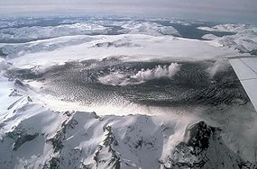
The Quizapu Crater is almost perfectly circular, and rises to a prominence of 150 to 250 m (492.1 to 820.2 ft) above the surrounding portions of the volcano. Cresting at 3292 metres (10,801 ft) in elevation, Quizapu is one the highest known Plinian craters. The radius of the crater floor, which is the current inner vent, is around 150 metres (492.1 ft), while the radius of its rim is 300–350 m (984.3–1,148.3 ft). The crater floor lies at 2928 metres (9,606 ft), and the rim lies 150–300 m (492.1–984.3 ft) above that, giving the walls an average slope of 34–35 degrees (close to the angle of repose
). The western wall is cut by two long, dacitic lava flows: probably the remnants of a dome
or an eruption. The crater is surrounded by debris from its 1932 eruption, and topped by layers—50 metres (164 ft) thick—of mafic scoria
and ash.
zone, characterized by hot and dry summers but mild and wet winters. The temperatures and precipitation
are strongly dependent on topography. In the Andes the annual average maximum temperatures lie in the range 20 to 25 °C (68 to 77 F), while minimum temperatures are below 0 °C (32 °F). Annual precipitation is up to 800 mm (31.5 inches).
Vegetation in the Andes varies with elevation. Above 1,600 meters (5,249 ft) the slopes of mountains are covered by Alpine
-like steppe
, while below there are zones of Nothofagus
forest, Hygrophilous forest, Sclerophylous forest
, and matorral
. The number of plant species is likely to exceed 2,000, although no comprehensive study of the flora of Central Chile has been undertaken.
s, and phreatic eruptions. Pyroclastic flow
s have also been observed as a result of some of these explosive eruptions. The earliest recorded eruption began on November 26, 1846, while the volcano's last eruption began on August 9, 1967. The volcano has produced two of the largest eruptions in South America in recorded history, in 1846 and 1932. Both released 4 – of the dacitic magma. (The more recently described eruption of Huaynaputina
in 1600 appears to have been larger.)
s, adjacent vents, or pre-eruptive activity exists. Most descriptions of the eruption come from the backcountry herdsmen (arriero
s). One, who was camped in a valley approximately 7 kilometres (4 mi) east of Quizapu, heard "a great noise and a cloud of ash" emanate from the mountain in the late afternoon. No precursor activity was reported, and the herdsman claimed that there were no earthquakes during the late afternoon eruption.
That night, two herdsmen near the site heard a continuous roar, punctuated by loud bangs and crackling sounds "like that of great rockslides". Lightning and thunder accompanied the spectacle. They saw many blue flames, and were choked by sulfurous gas
. Observers in Talca 85 kilometres (53 mi) away heard the eruption noises, and the sulfurous odors reached them the day after the eruption. None of the reports mention earthquakes or ash fall, though the crackling and banging sounds could be from block lavas (aā).
This first recorded eruption of Cerro Azul was effusive, and formed the volcanic vent at Quizapu. Hornblende–dacite lava erupted with small masses of tephra, which had been degassed shortly before the eruption. Lava flowed over the Estero Barroso Valley and westward into the Río Blanquillo Valley. By November 28, the volcano appeared at rest, and the herdsman returned to the place of first observation. There, they found a blocky lava field. The lava was still hot, fuming and crackling with gas and flame. Fascinated by the volcano, Ignacy Domeyko
traveled to Chile to study the field and found its width to be 8 –. By 1992 the field had grown to twice that size.
6 or 7 kilometers (about 4 mi) into the air over 8 minutes. By 1916, these eruptions had produced a caldera nearly identical to the one in existence today.
The volcano also erupted phreatically several times, as recorded by Vogel in 1913 and 1920, with its activity increasing from 1916 to 1926. During these years, the eruptions grew more frequent and more violent. A major outburst on November 2, 1927 started a period of nearly continuous violent eruptions that lasted until 1929. During this period, Cerro Azul sometimes erupted daily, sending columns of ash as far as 6 or 7 kilometers (about 4 mi) into the air. Quizapu Crater grew slightly during this eruptive period.
Pre-1932 volcanism was largely phreatic or fumarolic, as evidenced by the lack of tephra generated by these eruptions. Photographs from 1912 show vapor plumes containing little ash, rising 1–2 km (0.621372736649807–1.2 mi) above the crater.
saw a large black cloud over the summit. By 9 April, the volcano emitted green gas and started to "bellow like a bull". On April 10, Cerro Azul finally erupted, releasing a towering column
or plume of white gas. After 10 AM, the plume turned black with ash and began to form an umbrella shape. The ash was carried by wind into Puesto El Tristan in Argentina, about 47 kilometres (29 mi) away, where beginning at 1 PM it rained down for hours. At 4 PM, coarser sandy material and some pumice
lapilli
began to fall.
Cerro Azul's April 1932 eruption was one of the largest of the 20th century. Releasing 9.5 cubic kilometres (2 cu mi) of lava, the volcano ejected primarily dacitic
tephra, accompanied by rhyodacite
, andesite
, and minuscule amounts of andesitic and basalt
ic scoria
. At least one eruptive period lasted for 18 hours, creating an "exceptionally uniform" deposit. Eruption column
s, extending 27–30 km (16.8–18.6 mi) into the air, were sighted. Phenocrysts were similar to the effusive eruption in 1846. Soon after, both the Tinguiririca
and Descabezado Grande
volcanoes began erupting, sending clouds of ash
800 kilometres (497.1 mi) into Argentina. The eruption had a Volcanic Explosivity Index
(VEI) of at least 5.
Since the eruption of 1932 Quizapu has been quiet. In 1949 and 1967 small ash clouds were reported, while in 1980s there were no signs of activity other than furmarols.
, Llaima, and Villarrica. Villarrica and Llaima together have more than 80 reported episodes of volcanism since 1558, and at least 40 South Volcanic Zone volcanoes have had Holocene-age eruptions.
Every known type of eruption (Hawaiian
, Strombolian
, Plinian
, subplinian, phreatic
, phreatomagmatic
, and Vulcanian
) has occurred at some point in the range. Cerro Azul itself has experienced phreatic, Strombolian, and Plinian activity in human history. The type of eruption tends to correspond with lava composition. Strombolian eruptions at Llaima, Antuco, Villarrica, and elsewhere have been produced by basaltic to basaltic–andesitic activity. Dacitic
to rhyolitic
lavas have been linked to subplinian and Plinian eruptions, such as those at Quizapu (1932) and Hudson (1991). Because of this variability, volcanic hazards from Cerro Azul and the surrounding region could come in many different forms. Historical eruptions typically have produced lahars, lava flows, and ahsfalls. Lava flows and lahar
s could wipe out entire cities or towns. Ashfall produced by explosive eruptions could interfere with air traffic. Most threatening of all is the risk of pyroclastic flows or avalanches, which have historically traversed as far as 100 kilometres (62 mi) in the region.
 Past eruptions of Quizapu Crater ejected enormous amounts of ash that traveled as far as Brazil. After the 1932 eruption, the local vegetation was devastated, and the area remained barren until the 1990s, though human life was not impacted. Despite the extent of its eruptions, the threat to humans from Quizapu is relatively small because of the remote location of Cerro Azul. Nevertheless, the size of past eruptions is large enough for scientists to be worried. Evidence of a potentially deadly threat lies in a lahar at Descabezado Grande. Historically, lahars have killed thousands in the Andes. There is, however, a possibility that a large reservoir of rhyodacite magma may exist under the Azul–Descabezado complex. If this is the case, all previous eruptions in 1846–1967 were only preliminary, preclimactic leaks from the large magma chamber beneath, and a large caldera-forming eruption may be expected in the future.
If Cerro Azul were to erupt, relief efforts could be orchestrated. The Volcanic Disaster Assistance Program (VDAP) formed in response to the famous eruption of Nevado del Ruiz
in Colombia
, and saved lives following the 1991 eruption of Mount Hudson
in Chile by organizing evacuations. The team's stated aim is to "reduce eruption-caused fatalities and economic losses in developing countries". Made up of various USGS offices (such as the Cascades Volcano Observatory
; CVO that are responsible for monitoring Mount St. Helens
), the team is outfitted with equipment capable of monitoring any volcano. This equipment allows them to predict volcanic eruptions effectively and rapidly, and to evacuate nearby homes.
Stratovolcano
A stratovolcano, also known as a composite volcano, is a tall, conical volcano built up by many layers of hardened lava, tephra, pumice, and volcanic ash. Unlike shield volcanoes, stratovolcanoes are characterized by a steep profile and periodic, explosive eruptions...
in the Maule Region
Maule Region
The VII Maule Region is one of Chile's 15 first order administrative divisions. Its capital is Talca. The region takes its name from the Maule River which, running westward from the Andes, bisects the region and spans a basin of about 20,600 km2...
of central Chile
Chile
Chile ,officially the Republic of Chile , is a country in South America occupying a long, narrow coastal strip between the Andes mountains to the east and the Pacific Ocean to the west. It borders Peru to the north, Bolivia to the northeast, Argentina to the east, and the Drake Passage in the far...
, immediately south of Descabezado Grande
Descabezado Grande
Descabezado Grande is a stratovolcano located in the Maule Region of central Chile. It is capped by a ice-filled caldera and named for its flat-topped form, as descabezado means "headless" in Spanish...
. Part of the South Volcanic Zone
Andean Volcanic Belt
The Andean Volcanic Belt is a major volcanic belt along the Andean cordillera in Colombia, Bolivia, Peru, Ecuador, Chile and Argentina. It formed as a result of subduction of the Nazca Plate and Antarctic Plate underneath the South American Plate. The belt is subdivided into four main volcanic...
of the Andes
Andes
The Andes is the world's longest continental mountain range. It is a continual range of highlands along the western coast of South America. This range is about long, about to wide , and of an average height of about .Along its length, the Andes is split into several ranges, which are separated...
, its summit is 3788 metres (12,428 ft) above sea level
Sea level
Mean sea level is a measure of the average height of the ocean's surface ; used as a standard in reckoning land elevation...
, and is capped by a summit crater that is 500 metres (1,640.4 ft) wide and opens to the north. Beneath the summit, the volcano features numerous scoria
Scoria
Scoria is a volcanic rock containing many holes or vesicles. It is most generally dark in color , and basaltic or andesitic in composition. Scoria is relatively low in mass as a result of its numerous macroscopic ellipsoidal vesicles, but in contrast to pumice, all scoria has a specific gravity...
cones and flank vents.
Cerro Azul is responsible for several of South America's largest recorded eruptions, in 1846 and 1932. In 1846, an effusive eruption
Effusive eruption
An effusive eruption is a volcanic eruption characterized by the outpouring of lava onto the ground...
formed the vent at the site of present-day Quizapu crater on the northern flank of Cerro Azul and sent lava flowing down the sides of the volcano, creating a lava field 8–9 square kilometers (3–3.5 square miles) in area. Phreatic
Phreatic
The term phreatic is used in Earth sciences to refer to matters relating to ground water below the water table . The term 'phreatic surface' indicates the location where the pore water pressure is under atmospheric conditions...
and Strombolian volcanism between 1907 and 1932 excavated this crater. In 1932, one of the largest explosive eruptions of the 20th century occurred at Quizapu Crater and sent 9.5 cubic kilometres (2.3 cu mi) of ash into the atmosphere. The volcano's most recent eruption was in 1967.
The South Volcanic Zone
Andean Volcanic Belt
The Andean Volcanic Belt is a major volcanic belt along the Andean cordillera in Colombia, Bolivia, Peru, Ecuador, Chile and Argentina. It formed as a result of subduction of the Nazca Plate and Antarctic Plate underneath the South American Plate. The belt is subdivided into four main volcanic...
has a long history of eruptions and poses a threat to the surrounding region. Any volcanic hazard
Volcanic hazards
Volcanic hazards are threats to life and/or infrastructure due to volcanic activity and related phenomena such as floods and landslides at volcanoes.-Lava flows:...
—ranging from minor ashfalls to pyroclastic flow
Pyroclastic flow
A pyroclastic flow is a fast-moving current of superheated gas and rock , which reaches speeds moving away from a volcano of up to 700 km/h . The flows normally hug the ground and travel downhill, or spread laterally under gravity...
s—could pose a significant risk to humans and wildlife. Despite its inactivity, Cerro Azul could again produce a major eruption; if this were to happen, relief efforts would probably be quickly organized. Teams such as the Volcano Disaster Assistance Program
Volcano Disaster Assistance Program
The Volcano Disaster Assistance Program was developed by the U.S. Geological Survey and U.S. Office of Foreign Disaster Assistance after the eruption of Nevado del Ruiz in 1985 that killed 23,000 people...
(VDAP) are prepared to effectively evacuate, assist, and rescue people threatened by volcanic eruptions.
Regional setting
Volcanism in the Chilean AndesAndean Volcanic Belt
The Andean Volcanic Belt is a major volcanic belt along the Andean cordillera in Colombia, Bolivia, Peru, Ecuador, Chile and Argentina. It formed as a result of subduction of the Nazca Plate and Antarctic Plate underneath the South American Plate. The belt is subdivided into four main volcanic...
is caused by subduction
Subduction
In geology, subduction is the process that takes place at convergent boundaries by which one tectonic plate moves under another tectonic plate, sinking into the Earth's mantle, as the plates converge. These 3D regions of mantle downwellings are known as "Subduction Zones"...
of the Nazca
Nazca Plate
]The Nazca Plate, named after the Nazca region of southern Peru, is an oceanic tectonic plate in the eastern Pacific Ocean basin off the west coast of South America. The ongoing subduction along the Peru-Chile Trench of the Nazca Plate under the South American Plate is largely responsible for the...
and Antarctic
Antarctic Plate
The Antarctic Plate is a tectonic plate covering the continent of Antarctica and extending outward under the surrounding oceans. The Antarctic Plate has a boundary with the Nazca Plate, the South American Plate, the African Plate, the Indo-Australian Plate, the Scotia Plate and a divergent boundary...
tectonic plates under the South American Plate
South American Plate
The South American Plate is a continental tectonic plate which includes the continent of South America and also a sizeable region of the Atlantic Ocean seabed extending eastward to the Mid-Atlantic Ridge....
. Volcanoes in Chile occur in the Central (CVZ), South (SVZ), and Austral Volcanic Zones (AVZ). The gap that separates the Central and South Volcanic Zones is caused by shallow-angle subduction in the Pampean flat-slab segment where the more buoyant Juan Fernández Ridge
Juan Fernández Ridge
The Juan Fernández Ridge is a volcanic island and seamount chain on the Nazca Plate. It runs in a west-east direction from the Juan Fernández hotspot to the Peru-Chile Trench at a latitude of 33° S near Valparaíso. The Juan Fernández Islands are the only seamounts that reach the surface....
subducts under the South American continent. This buoyant region prevents the slab
Slab (geology)
In geology, a slab is the portion of a tectonic plate that is being subducted.Slabs constitute an important part of the global plate tectonic system. They drive plate tectonics both by pulling along the lithosphere to which they are attached in a processes known as slab pull and by inciting...
(subducting tectonic plate) from diving deep into the mantle
Mantle (geology)
The mantle is a part of a terrestrial planet or other rocky body large enough to have differentiation by density. The interior of the Earth, similar to the other terrestrial planets, is chemically divided into layers. The mantle is a highly viscous layer between the crust and the outer core....
, where the heat and pressure would destabilize the mineral chlorite
Chlorite group
The chlorites are a group of phyllosilicate minerals. Chlorites can be described by the following four endmembers based on their chemistry via substitution of the following four elements in the silicate lattice; Mg, Fe, Ni, and Mn....
, releasing water that would in turn cause melting
Flux melting
In igneous petrology flux melting occurs when water and other volatile components are added to a hot solid rock. The ultramafic rock of the upper mantle can be melted by the addition of volatiles from below. The source of the water and volatiles is the subducting slab of oceanic crust which...
and volcanism
Volcanism
Volcanism is the phenomenon connected with volcanoes and volcanic activity. It includes all phenomena resulting from and causing magma within the crust or mantle of a planet to rise through the crust and form volcanic rocks on the surface....
. The Patagonian Volcanic Gap, which separates the South and Austral Volcanic Zones, is caused by the subduction of the Chile Ridge, though it is less clear whether this gap also is due to flat-slab subduction; it may instead arise because melting of the subducting slab there produced felsic
Felsic
The word "felsic" is a term used in geology to refer to silicate minerals, magma, and rocks which are enriched in the lighter elements such as silicon, oxygen, aluminium, sodium, and potassium....
igneous rock
Igneous rock
Igneous rock is one of the three main rock types, the others being sedimentary and metamorphic rock. Igneous rock is formed through the cooling and solidification of magma or lava...
s instead of volcanoes.
Offshore volcanism also occurs in Chile. Intraplate volcanism generated from the Easter
Easter hotspot
The Easter hotspot is a volcanic hotspot located in the southeastern Pacific Ocean. The hotspot created the Sala y Gómez Ridge which includes Easter Island and the Pukao Seamount which is at the ridge's young western edge....
and Juan Fernández
Juan Fernández hotspot
The Juan Fernández hotspot is a volcanic hotspot located in the southeastern Pacific Ocean. The hotspot created the Juan Fernández Ridge which includes the Juan Fernández Archipelago and a long seamount chain that is being subducted in the Peru-Chile Trench at the site of Papudo giving origin to...
hotspot
Hotspot (geology)
The places known as hotspots or hot spots in geology are volcanic regions thought to be fed by underlying mantle that is anomalously hot compared with the mantle elsewhere. They may be on, near to, or far from tectonic plate boundaries. There are two hypotheses to explain them...
s has formed many Chilean islands, including Isla Salas y Gómez, Easter Island
Easter Island
Easter Island is a Polynesian island in the southeastern Pacific Ocean, at the southeasternmost point of the Polynesian triangle. A special territory of Chile that was annexed in 1888, Easter Island is famous for its 887 extant monumental statues, called moai, created by the early Rapanui people...
, and the Juan Fernández Islands
Juan Fernández Islands
The Juan Fernández Islands are a sparsely inhabited island group reliant on tourism and fishing in the South Pacific Ocean, situated about off the coast of Chile, and is composed of three main volcanic islands; Robinson Crusoe Island, Alejandro Selkirk Island and Santa Clara Island, the first...
. Underwater volcanism occurs due to seafloor spreading
Seafloor spreading
Seafloor spreading is a process that occurs at mid-ocean ridges, where new oceanic crust is formed through volcanic activity and then gradually moves away from the ridge. Seafloor spreading helps explain continental drift in the theory of plate tectonics....
along the Chile Ridge.
Nearly 100 Quaternary
Quaternary
The Quaternary Period is the most recent of the three periods of the Cenozoic Era in the geologic time scale of the ICS. It follows the Neogene Period, spanning 2.588 ± 0.005 million years ago to the present...
(Pleistocene
Pleistocene
The Pleistocene is the epoch from 2,588,000 to 11,700 years BP that spans the world's recent period of repeated glaciations. The name pleistocene is derived from the Greek and ....
- or Holocene
Holocene
The Holocene is a geological epoch which began at the end of the Pleistocene and continues to the present. The Holocene is part of the Quaternary period. Its name comes from the Greek words and , meaning "entirely recent"...
-age) independent volcanoes exist in the country, in addition to 60 volcanic complexes and caldera
Caldera
A caldera is a cauldron-like volcanic feature usually formed by the collapse of land following a volcanic eruption, such as the one at Yellowstone National Park in the US. They are sometimes confused with volcanic craters...
systems. Of the 200 historically active volcanoes in the Andean Range, 36 are found in Chile.
Local setting
Cerro Azul is part of the South Volcanic Zone, which runs through central and western Chile and extends south to Argentina. This range includes at least nine caldera complexesVolcanic field
A volcanic field is an area of the Earth's crust that is prone to localized volcanic activity. They usually contain 10 to 100 volcanoes, such as cinder cones and are usually in clusters. Lava flows may also occur...
, more than 70 of Chile's stratovolcanoes and volcanic fields that have been active in the Quaternary, and hundreds of minor eruptive centres. The South Volcanic Zone is the most volcanically active region in Chile, and produces around one eruption per year. Its largest historical eruption was at Quizapu Crater, located on the north side of Cerro Azul's summit (see below), and its most active volcanoes are Llaima
Llaima
Llaima Volcano is one of the largest and most active volcanoes in Chile. It is situated 82 km northeast of Temuco and 663 km southeast of Santiago, within the borders of Conguillío National Park.-Geography:...
and Villarrica
Villarrica (volcano)
Villarrica is one of Chile's most active volcanoes, rising above the lake and town of the same name. The volcano is also known as Rucapillán, a Mapuche word meaning "House of the Pillán". It is the westernmost of three large stratovolcanoes that trend perpendicular to the Andean chain along the...
.
Cerro Azul, just 7 kilometres (4.3 mi) south of Descabezado Grande
Descabezado Grande
Descabezado Grande is a stratovolcano located in the Maule Region of central Chile. It is capped by a ice-filled caldera and named for its flat-topped form, as descabezado means "headless" in Spanish...
volcano, is part of the Descabezado Grande–Cerro Azul eruptive system, a volcanic field
Volcanic field
A volcanic field is an area of the Earth's crust that is prone to localized volcanic activity. They usually contain 10 to 100 volcanoes, such as cinder cones and are usually in clusters. Lava flows may also occur...
which comprises its two large namesake volcanic edifices and several smaller vents, including 12 Holocene calderas. Both volcanoes lie on top of the Casitas Shield, a plateau built of over 100 lava flows that erupted in at least 12 volcanic episodes during the Quaternary period. The upper lava layers are dated at 340,000 years.
As with the majority of the Andean volcanoes, Cerro Azul is a stratovolcano
Stratovolcano
A stratovolcano, also known as a composite volcano, is a tall, conical volcano built up by many layers of hardened lava, tephra, pumice, and volcanic ash. Unlike shield volcanoes, stratovolcanoes are characterized by a steep profile and periodic, explosive eruptions...
, meaning that it consists of layers, or strata
Stratum
In geology and related fields, a stratum is a layer of sedimentary rock or soil with internally consistent characteristics that distinguish it from other layers...
, of volcanic ash
Volcanic ash
Volcanic ash consists of small tephra, which are bits of pulverized rock and glass created by volcanic eruptions, less than in diameter. There are three mechanisms of volcanic ash formation: gas release under decompression causing magmatic eruptions; thermal contraction from chilling on contact...
and lava flows. The cone of Cerro Azul has a total volume of about 11 cubic kilometres (3 cu mi), and is a young feature, formed in the Holocene
Holocene
The Holocene is a geological epoch which began at the end of the Pleistocene and continues to the present. The Holocene is part of the Quaternary period. Its name comes from the Greek words and , meaning "entirely recent"...
. It is made of agglutinated pyroclasts and some dacite
Dacite
Dacite is an igneous, volcanic rock. It has an aphanitic to porphyritic texture and is intermediate in composition between andesite and rhyolite. The relative proportions of feldspars and quartz in dacite, and in many other volcanic rocks, are illustrated in the QAPF diagram...
–andesine
Andesine
Andesine is a silicate mineral, a member of the plagioclase feldspar solid solution series. Its chemical formula is 4O8, where Ca/ is between 30%-50%...
lavas. The cone has a few volcanic craters; the majority of its eruptions in recorded history have originated from Quizapu Crater on the northern flank of Cerro Azul's cone. Other craters lying on the flanks of the main cone are Caracol ("Snail"), Crater los Quillayes, Crater la Resolana, and Crater sin Nombre ("Nameless Crater"). All of the craters lie between 2000 metre in elevation, except Quizapu, which is 3292 metres (10,800.5 ft) up the volcano. The summit of Cerro Azul is crowned by an asymmetric crater about 500 metres (1,640 ft) in diameter. Pleistocene
Pleistocene
The Pleistocene is the epoch from 2,588,000 to 11,700 years BP that spans the world's recent period of repeated glaciations. The name pleistocene is derived from the Greek and ....
glacial activity is evident in the form of 500 meter (1,640 ft) deep struts in the volcanoes' sides. These deep cuts have revealed strata
Stratum
In geology and related fields, a stratum is a layer of sedimentary rock or soil with internally consistent characteristics that distinguish it from other layers...
of older rock.
Quizapu Crater
Quizapu, which formed during the 1846 eruption, is the most prominent crater. It is also known as Cerro del Medio ("Middle Hill") or Volcan Nuevo ("New Volcano"). The volcanic vent formed during an effusive eruption involving hornblendeHornblende
Hornblende is a complex inosilicate series of minerals .It is not a recognized mineral in its own right, but the name is used as a general or field term, to refer to a dark amphibole....
–dacite flows accompanied by tephra
Tephra
200px|thumb|right|Tephra horizons in south-central [[Iceland]]. The thick and light coloured layer at center of the photo is [[rhyolitic]] tephra from [[Hekla]]....
, and the crater was excavated by phreatic
Phreatic eruption
A phreatic eruption, also called a phreatic explosion or ultravulcanian eruption, occurs when rising magma makes contact with ground or surface water. The extreme temperature of the magma causes near-instantaneous evaporation to steam, resulting in an explosion of steam, water, ash, rock, and...
and Strombolian
Strombolian eruption
Strombolian eruptions are relatively low-level volcanic eruptions, named after the Italian volcano Stromboli, where such eruptions consist of ejection of incandescent cinder, lapilli and lava bombs to altitudes of tens to hundreds of meters...
eruptions between 1907 and 1932. Pent-up pressure within the volcano spawned an enormous Plinian eruption
Plinian eruption
Plinian eruptions, also known as 'Vesuvian eruptions', are volcanic eruptions marked by their similarity to the eruption of Mount Vesuvius in AD 79 ....
in 1932. The volume of lava ejected during this single event is roughly equal to that ejected during the rest of the eruptive history at Quizapu, since its formation in 1846. Although 9.5 cubic kilometres (2.3 cu mi) of material was ejected, no subsidence
Subsidence
Subsidence is the motion of a surface as it shifts downward relative to a datum such as sea-level. The opposite of subsidence is uplift, which results in an increase in elevation...
was detected from the removal of magma. Because of aerodynamic drag
Drag (physics)
In fluid dynamics, drag refers to forces which act on a solid object in the direction of the relative fluid flow velocity...
, a Plinian eruption excavates a circular crater. As the earlier eruptions had already formed an approximately circular caldera, the Plinian eruption was able to proceed efficiently, with minimal drag and minimal reshaping of the crater.
The Quizapu Crater is almost perfectly circular, and rises to a prominence of 150 to 250 m (492.1 to 820.2 ft) above the surrounding portions of the volcano. Cresting at 3292 metres (10,801 ft) in elevation, Quizapu is one the highest known Plinian craters. The radius of the crater floor, which is the current inner vent, is around 150 metres (492.1 ft), while the radius of its rim is 300–350 m (984.3–1,148.3 ft). The crater floor lies at 2928 metres (9,606 ft), and the rim lies 150–300 m (492.1–984.3 ft) above that, giving the walls an average slope of 34–35 degrees (close to the angle of repose
Angle of repose
The angle of repose or, more precisely, the critical angle of repose, of a granular material is the steepest angle of descent or dip of the slope relative to the horizontal plane when material on the slope face is on the verge of sliding. This angle is in the range 0°–90°.When bulk granular...
). The western wall is cut by two long, dacitic lava flows: probably the remnants of a dome
Lava dome
|250px|thumb|right|Image of the [[rhyolitic]] lava dome of [[Chaitén Volcano]] during its 2008–2009 eruption.In volcanology, a lava dome is a roughly circular mound-shaped protrusion resulting from the slow extrusion of viscous lava from a volcano...
or an eruption. The crater is surrounded by debris from its 1932 eruption, and topped by layers—50 metres (164 ft) thick—of mafic scoria
Scoria
Scoria is a volcanic rock containing many holes or vesicles. It is most generally dark in color , and basaltic or andesitic in composition. Scoria is relatively low in mass as a result of its numerous macroscopic ellipsoidal vesicles, but in contrast to pumice, all scoria has a specific gravity...
and ash.
Climate and vegetation
Cerro Azul is situated in a Mediterranean climateMediterranean climate
A Mediterranean climate is the climate typical of most of the lands in the Mediterranean Basin, and is a particular variety of subtropical climate...
zone, characterized by hot and dry summers but mild and wet winters. The temperatures and precipitation
Precipitation (meteorology)
In meteorology, precipitation In meteorology, precipitation In meteorology, precipitation (also known as one of the classes of hydrometeors, which are atmospheric water phenomena is any product of the condensation of atmospheric water vapor that falls under gravity. The main forms of precipitation...
are strongly dependent on topography. In the Andes the annual average maximum temperatures lie in the range 20 to 25 °C (68 to 77 F), while minimum temperatures are below 0 °C (32 °F). Annual precipitation is up to 800 mm (31.5 inches).
Vegetation in the Andes varies with elevation. Above 1,600 meters (5,249 ft) the slopes of mountains are covered by Alpine
Alpine climate
Alpine climate is the average weather for a region above the tree line. This climate is also referred to as mountain climate or highland climate....
-like steppe
Steppe
In physical geography, steppe is an ecoregion, in the montane grasslands and shrublands and temperate grasslands, savannas, and shrublands biomes, characterized by grassland plains without trees apart from those near rivers and lakes...
, while below there are zones of Nothofagus
Nothofagus
Nothofagus, also known as the southern beeches, is a genus of 35 species of trees and shrubs native to the temperate oceanic to tropical Southern Hemisphere in southern South America and Australasia...
forest, Hygrophilous forest, Sclerophylous forest
Mediterranean forests, woodlands, and scrub
Mediterranean forests, woodlands, and scrub biome, defined by the World Wildlife Fund, characterized by dry summers and rainy winters. Summers are typically hot in low-lying inland locations but can be cool near some seas, as near San Francisco, which have a sea of cool waters...
, and matorral
Matorral
Matorral is a Spanish word, along with tomillares, for shrubland, thicket or bushes. It is used in naming and describing a Mediterranean climate ecosystem in Southern Europe.-Mediterranean region:...
. The number of plant species is likely to exceed 2,000, although no comprehensive study of the flora of Central Chile has been undertaken.
Eruptive history
Cerro Azul has a history of eruptions dating back to at least 1846. The known events include effusive eruptions (lava flows), which created the Quizapu vent, explosive eruptionExplosive eruption
An explosive eruption is a volcanic term to describe a violent, explosive type of eruption. Mount St. Helens in 1980 was an example. Such an eruption is driven by gas accumulating under great pressure. Driven by hot rising magma, it interacts with ground water until the pressure increases to the...
s, and phreatic eruptions. Pyroclastic flow
Pyroclastic flow
A pyroclastic flow is a fast-moving current of superheated gas and rock , which reaches speeds moving away from a volcano of up to 700 km/h . The flows normally hug the ground and travel downhill, or spread laterally under gravity...
s have also been observed as a result of some of these explosive eruptions. The earliest recorded eruption began on November 26, 1846, while the volcano's last eruption began on August 9, 1967. The volcano has produced two of the largest eruptions in South America in recorded history, in 1846 and 1932. Both released 4 – of the dacitic magma. (The more recently described eruption of Huaynaputina
Huaynaputina
Huaynaputina is a stratovolcano located in a volcanic upland in southern Peru. The volcano does not have an identifiable mountain profile, but instead has the form of a large volcanic crater. It has produced high-potassium andesite and dacite...
in 1600 appears to have been larger.)
First record of activity, 1846
On November 26, 1846, Cerro Azul erupted. This was the first report of activity at the volcano, and no trace of fumaroleFumarole
A fumarole is an opening in a planet's crust, often in the neighborhood of volcanoes, which emits steam and gases such as carbon dioxide, sulfur dioxide, hydrochloric acid, and hydrogen sulfide. The steam is created when superheated water turns to steam as its pressure drops when it emerges from...
s, adjacent vents, or pre-eruptive activity exists. Most descriptions of the eruption come from the backcountry herdsmen (arriero
Arriero
thumb|250px|right|An arriero loading a [[pack horse]] in [[Zona Sur|southern Chile]]An arriero is a person who transports goods using pack animals.In South America, arrieros transport coffee, maize, cork, wheat, and myriad other items...
s). One, who was camped in a valley approximately 7 kilometres (4 mi) east of Quizapu, heard "a great noise and a cloud of ash" emanate from the mountain in the late afternoon. No precursor activity was reported, and the herdsman claimed that there were no earthquakes during the late afternoon eruption.
That night, two herdsmen near the site heard a continuous roar, punctuated by loud bangs and crackling sounds "like that of great rockslides". Lightning and thunder accompanied the spectacle. They saw many blue flames, and were choked by sulfurous gas
Sulfur
Sulfur or sulphur is the chemical element with atomic number 16. In the periodic table it is represented by the symbol S. It is an abundant, multivalent non-metal. Under normal conditions, sulfur atoms form cyclic octatomic molecules with chemical formula S8. Elemental sulfur is a bright yellow...
. Observers in Talca 85 kilometres (53 mi) away heard the eruption noises, and the sulfurous odors reached them the day after the eruption. None of the reports mention earthquakes or ash fall, though the crackling and banging sounds could be from block lavas (aā).
This first recorded eruption of Cerro Azul was effusive, and formed the volcanic vent at Quizapu. Hornblende–dacite lava erupted with small masses of tephra, which had been degassed shortly before the eruption. Lava flowed over the Estero Barroso Valley and westward into the Río Blanquillo Valley. By November 28, the volcano appeared at rest, and the herdsman returned to the place of first observation. There, they found a blocky lava field. The lava was still hot, fuming and crackling with gas and flame. Fascinated by the volcano, Ignacy Domeyko
Ignacy Domeyko
Ignacy Domeyko or Domejko was a 19th-century geologist, mineralogist and educator who was born in Nesvizh, Imperial Russia , into a Polish-Lithuanian family...
traveled to Chile to study the field and found its width to be 8 –. By 1992 the field had grown to twice that size.
Early 20th century
Cerro Azul was quiet from 1846 to the beginning of the 20th century. After a possible precursor explosive event in 1903, Cerro Azul once again erupted in 1907. Between 1907 and 1914, plumes and clouds of ash frequently rose out of the caldera, and at least a few of these events were explosive. On September 8, 1914, an explosive eruption sent a plumeEruption column
An eruption column consists of hot volcanic ash emitted during an explosive volcanic eruption. The ash forms a column rising many kilometres into the air above the peak of the volcano. In the most explosive eruptions, the eruption column may rise over 40 km, penetrating the stratosphere...
6 or 7 kilometers (about 4 mi) into the air over 8 minutes. By 1916, these eruptions had produced a caldera nearly identical to the one in existence today.
The volcano also erupted phreatically several times, as recorded by Vogel in 1913 and 1920, with its activity increasing from 1916 to 1926. During these years, the eruptions grew more frequent and more violent. A major outburst on November 2, 1927 started a period of nearly continuous violent eruptions that lasted until 1929. During this period, Cerro Azul sometimes erupted daily, sending columns of ash as far as 6 or 7 kilometers (about 4 mi) into the air. Quizapu Crater grew slightly during this eruptive period.
Pre-1932 volcanism was largely phreatic or fumarolic, as evidenced by the lack of tephra generated by these eruptions. Photographs from 1912 show vapor plumes containing little ash, rising 1–2 km (0.621372736649807–1.2 mi) above the crater.
Major eruption, 1932
By 1932, Quizapu had produced many phreatic events and one effusive eruption, but no large Plinian eruptions. This frequency of minor eruptive activity proved to be a precursor for a major eruption. On 25 January 1932, observers in MalargueMalargüe
- Transport and infrastructures :- Transportation :Malargüe is linked to the north of Mendoza by National Route 40. This route continues south, entering Neuquén Province, but is only partially built and not well maintained beyond Malargüe City....
saw a large black cloud over the summit. By 9 April, the volcano emitted green gas and started to "bellow like a bull". On April 10, Cerro Azul finally erupted, releasing a towering column
Eruption column
An eruption column consists of hot volcanic ash emitted during an explosive volcanic eruption. The ash forms a column rising many kilometres into the air above the peak of the volcano. In the most explosive eruptions, the eruption column may rise over 40 km, penetrating the stratosphere...
or plume of white gas. After 10 AM, the plume turned black with ash and began to form an umbrella shape. The ash was carried by wind into Puesto El Tristan in Argentina, about 47 kilometres (29 mi) away, where beginning at 1 PM it rained down for hours. At 4 PM, coarser sandy material and some pumice
Pumice
Pumice is a textural term for a volcanic rock that is a solidified frothy lava typically created when super-heated, highly pressurized rock is violently ejected from a volcano. It can be formed when lava and water are mixed. This unusual formation is due to the simultaneous actions of rapid...
lapilli
Lapilli
Lapilli is a size classification term for tephra, which is material that falls out of the air during a volcanic eruption or during some meteorite impacts. Lapilli means "little stones" in Latin. They are in some senses similar to ooids or pisoids in calcareous sediments.By definition lapilli range...
began to fall.
Cerro Azul's April 1932 eruption was one of the largest of the 20th century. Releasing 9.5 cubic kilometres (2 cu mi) of lava, the volcano ejected primarily dacitic
Dacite
Dacite is an igneous, volcanic rock. It has an aphanitic to porphyritic texture and is intermediate in composition between andesite and rhyolite. The relative proportions of feldspars and quartz in dacite, and in many other volcanic rocks, are illustrated in the QAPF diagram...
tephra, accompanied by rhyodacite
Rhyodacite
Rhyodacite is an extrusive volcanic rock intermediate in composition between dacite and rhyolite. It is the extrusive equivalent of granodiorite. Phenocrysts of sodium rich plagioclase, sanidine, quartz, and biotite or hornblende are typically set in an aphanitic to glassy light to intermediate...
, andesite
Andesite
Andesite is an extrusive igneous, volcanic rock, of intermediate composition, with aphanitic to porphyritic texture. In a general sense, it is the intermediate type between basalt and dacite. The mineral assemblage is typically dominated by plagioclase plus pyroxene and/or hornblende. Magnetite,...
, and minuscule amounts of andesitic and basalt
Basalt
Basalt is a common extrusive volcanic rock. It is usually grey to black and fine-grained due to rapid cooling of lava at the surface of a planet. It may be porphyritic containing larger crystals in a fine matrix, or vesicular, or frothy scoria. Unweathered basalt is black or grey...
ic scoria
Scoria
Scoria is a volcanic rock containing many holes or vesicles. It is most generally dark in color , and basaltic or andesitic in composition. Scoria is relatively low in mass as a result of its numerous macroscopic ellipsoidal vesicles, but in contrast to pumice, all scoria has a specific gravity...
. At least one eruptive period lasted for 18 hours, creating an "exceptionally uniform" deposit. Eruption column
Eruption column
An eruption column consists of hot volcanic ash emitted during an explosive volcanic eruption. The ash forms a column rising many kilometres into the air above the peak of the volcano. In the most explosive eruptions, the eruption column may rise over 40 km, penetrating the stratosphere...
s, extending 27–30 km (16.8–18.6 mi) into the air, were sighted. Phenocrysts were similar to the effusive eruption in 1846. Soon after, both the Tinguiririca
Tinguiririca (volcano)
Tinguiririca Volcano is a massive and active stratovolcano located in Chile's 6th or O'Higgins Region and near the Argentinian border. Constant fumarolic activity occurs within and on the NW wall of its summit crater and hot springs and fumaroles can also be seen on the western flanks, as...
and Descabezado Grande
Descabezado Grande
Descabezado Grande is a stratovolcano located in the Maule Region of central Chile. It is capped by a ice-filled caldera and named for its flat-topped form, as descabezado means "headless" in Spanish...
volcanoes began erupting, sending clouds of ash
Volcanic ash
Volcanic ash consists of small tephra, which are bits of pulverized rock and glass created by volcanic eruptions, less than in diameter. There are three mechanisms of volcanic ash formation: gas release under decompression causing magmatic eruptions; thermal contraction from chilling on contact...
800 kilometres (497.1 mi) into Argentina. The eruption had a Volcanic Explosivity Index
Volcanic Explosivity Index
The Volcanic Explosivity Index was devised by Chris Newhall of the U.S. Geological Survey and Stephen Self at the University of Hawaii in 1982 to provide a relative measure of the explosiveness of volcanic eruptions....
(VEI) of at least 5.
Since the eruption of 1932 Quizapu has been quiet. In 1949 and 1967 small ash clouds were reported, while in 1980s there were no signs of activity other than furmarols.
Threats and preparedness
Cerro Azul is in the South Volcanic Zone, where many volcanoes pose a threat to human life. Among the other active volcanoes of the South Volcanic Zone are Mount HudsonMount Hudson
Mount Hudson is a stratovolcano in southern Chile, and the site of one of the largest eruptions in the twentieth century. The mountain itself is covered by a glacier. There is a caldera at the summit from an ancient eruption; modern volcanic activity comes from inside the caldera...
, Llaima, and Villarrica. Villarrica and Llaima together have more than 80 reported episodes of volcanism since 1558, and at least 40 South Volcanic Zone volcanoes have had Holocene-age eruptions.
Every known type of eruption (Hawaiian
Hawaiian eruption
A Hawaiian eruption is a type of volcanic eruption where lava flows from the vent in a relative gentle, low level eruption, so called because it is characteristic of Hawaiian volcanoes. Typically they are effusive eruptions, with basaltic magmas of low viscosity, low content of gases, and high...
, Strombolian
Strombolian eruption
Strombolian eruptions are relatively low-level volcanic eruptions, named after the Italian volcano Stromboli, where such eruptions consist of ejection of incandescent cinder, lapilli and lava bombs to altitudes of tens to hundreds of meters...
, Plinian
Plinian eruption
Plinian eruptions, also known as 'Vesuvian eruptions', are volcanic eruptions marked by their similarity to the eruption of Mount Vesuvius in AD 79 ....
, subplinian, phreatic
Phreatic eruption
A phreatic eruption, also called a phreatic explosion or ultravulcanian eruption, occurs when rising magma makes contact with ground or surface water. The extreme temperature of the magma causes near-instantaneous evaporation to steam, resulting in an explosion of steam, water, ash, rock, and...
, phreatomagmatic
Phreatomagmatic eruption
Phreatomagmatic eruptions are defined as juvenile forming eruptions as a result of interaction between water and magma. They are different from magmatic and phreatic eruptions. The products of phreatomagmatic eruptions contain juvenile clasts, unlike phreatic eruptions, and are the result of...
, and Vulcanian
Vulcanian eruption
The term Vulcanian was first used by Giuseppe Mercalli, witnessing the 1888-1890 eruptions on the island of Vulcano. His description of the eruption style is now used all over the world for eruptions characterised by a dense cloud of ash-laden gas exploding from the crater and rising high above the...
) has occurred at some point in the range. Cerro Azul itself has experienced phreatic, Strombolian, and Plinian activity in human history. The type of eruption tends to correspond with lava composition. Strombolian eruptions at Llaima, Antuco, Villarrica, and elsewhere have been produced by basaltic to basaltic–andesitic activity. Dacitic
Dacite
Dacite is an igneous, volcanic rock. It has an aphanitic to porphyritic texture and is intermediate in composition between andesite and rhyolite. The relative proportions of feldspars and quartz in dacite, and in many other volcanic rocks, are illustrated in the QAPF diagram...
to rhyolitic
Rhyolite
This page is about a volcanic rock. For the ghost town see Rhyolite, Nevada, and for the satellite system, see Rhyolite/Aquacade.Rhyolite is an igneous, volcanic rock, of felsic composition . It may have any texture from glassy to aphanitic to porphyritic...
lavas have been linked to subplinian and Plinian eruptions, such as those at Quizapu (1932) and Hudson (1991). Because of this variability, volcanic hazards from Cerro Azul and the surrounding region could come in many different forms. Historical eruptions typically have produced lahars, lava flows, and ahsfalls. Lava flows and lahar
Lahar
A lahar is a type of mudflow or debris flow composed of a slurry of pyroclastic material, rocky debris, and water. The material flows down from a volcano, typically along a river valley. The term is a shortened version of "berlahar" which originated in the Javanese language of...
s could wipe out entire cities or towns. Ashfall produced by explosive eruptions could interfere with air traffic. Most threatening of all is the risk of pyroclastic flows or avalanches, which have historically traversed as far as 100 kilometres (62 mi) in the region.
If Cerro Azul were to erupt, relief efforts could be orchestrated. The Volcanic Disaster Assistance Program (VDAP) formed in response to the famous eruption of Nevado del Ruiz
Nevado del Ruiz
The Nevado del Ruiz, also known as La Mesa de Herveo or Kumanday in the language of the local pre-Columbian indigenous people, is a volcano located on the border of the departments of Caldas and Tolima in Colombia, about west of the capital city Bogotá. It is a stratovolcano, composed of many...
in Colombia
Colombia
Colombia, officially the Republic of Colombia , is a unitary constitutional republic comprising thirty-two departments. The country is located in northwestern South America, bordered to the east by Venezuela and Brazil; to the south by Ecuador and Peru; to the north by the Caribbean Sea; to the...
, and saved lives following the 1991 eruption of Mount Hudson
Mount Hudson
Mount Hudson is a stratovolcano in southern Chile, and the site of one of the largest eruptions in the twentieth century. The mountain itself is covered by a glacier. There is a caldera at the summit from an ancient eruption; modern volcanic activity comes from inside the caldera...
in Chile by organizing evacuations. The team's stated aim is to "reduce eruption-caused fatalities and economic losses in developing countries". Made up of various USGS offices (such as the Cascades Volcano Observatory
Cascades Volcano Observatory
The David A. Johnston Cascades Volcano Observatory is the volcano observatory that monitors volcanoes in the Cascade Range. It is part of the United States Geological Survey, a scientific agency of the United States government. It is located in Vancouver, Washington in the Portland, Oregon...
; CVO that are responsible for monitoring Mount St. Helens
Mount St. Helens
Mount St. Helens is an active stratovolcano located in Skamania County, Washington, in the Pacific Northwest region of the United States. It is south of Seattle, Washington and northeast of Portland, Oregon. Mount St. Helens takes its English name from the British diplomat Lord St Helens, a...
), the team is outfitted with equipment capable of monitoring any volcano. This equipment allows them to predict volcanic eruptions effectively and rapidly, and to evacuate nearby homes.