| Name |
Remains |
Location |
Date |
| Description |
Refs |
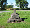
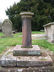
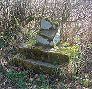
| Acton churchyard cross |
Stone structure |
ActonActon is a small village and civil parish lying immediately west of the town of Nantwich in the unitary authority of Cheshire East and the ceremonial county of...
53.0736°N 2.5513°W |
MedievalThe Middle Ages is a periodization of European history from the 5th century to the 15th century. The Middle Ages follows the fall of the Western Roman Empire in 476 and precedes the Early Modern Era. It is the middle period of a three-period division of Western history: Classic, Medieval and Modern...
|
32562 |
The remains of a cross The Christian cross, seen as a representation of the instrument of the crucifixion of Jesus Christ, is the best-known religious symbol of Christianity...
which consist of an octagonal shaft on three steps in St Mary'sSt Mary's Church, Acton is an active Anglican church in Acton, a village to the west of Nantwich, Cheshire, England. It has been designated by English Heritage as a Grade I listed building. A church has been present on this site since before the time of the Domesday Survey. The tower is the...
churchyard. In the late 17th century it was made into a sundialA sundial is a device that measures time by the position of the Sun. In common designs such as the horizontal sundial, the sun casts a shadow from its style onto a surface marked with lines indicating the hours of the day. The style is the time-telling edge of the gnomon, often a thin rod or a...
by the addition of a square cap with a ball finialThe finial is an architectural device, typically carved in stone and employed decoratively to emphasize the apex of a gable or any of various distinctive ornaments at the top, end, or corner of a building or structure. Smaller finials can be used as a decorative ornament on the ends of curtain rods...
. It is listed Grade II. |
|
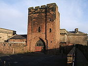
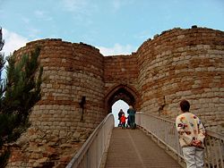
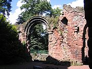
Agricola Tower, Chester CastleChester Castle is in the city of Chester, Cheshire, England. It is sited at the southwest extremity of the area bounded by the city walls . The castle stands on an eminence overlooking the River Dee. In the castle complex are the remaining parts of the medieval castle together with the...
|
SandstoneSandstone is a sedimentary rock composed mainly of sand-sized minerals or rock grains.Most sandstone is composed of quartz and/or feldspar because these are the most common minerals in the Earth's crust. Like sand, sandstone may be any colour, but the most common colours are tan, brown, yellow,...
tower |
ChesterChester is a city in Cheshire, England. Lying on the River Dee, close to the border with Wales, it is home to 77,040 inhabitants, and is the largest and most populous settlement of the wider unitary authority area of Cheshire West and Chester, which had a population of 328,100 according to the...
53.18538°N 2.89212°W |
Late 12th century |
CH24 |
The three-storeyed gate tower of the castle with later alterations and additions. It is a Grade I listed building. |
|
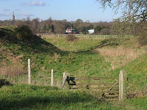
| Alderhedge Wood moat |
MoatA moat is a deep, broad ditch, either dry or filled with water, that surrounds a castle, other building or town, historically to provide it with a preliminary line of defence. In some places moats evolved into more extensive water defences, including natural or artificial lakes, dams and sluices...
|
Near Arley Arley is a small village in the civil parish of Aston by Budworth, Cheshire, England adjacent to Arley Hall. 0.7 miles to the east is a small group of houses known as Arley Green. The village is 3.8 miles south of Lymm and 5 miles north of Northwich.The buildings now comprising Arley Green...
53.3174°N 2.4748°W |
Medieval |
13484 |
A rectangular water-filled moat measuring about 54m x 55m with a fishpond and connecting channel. |
|
| Aldford Castle Aldford Castle is in the village of Aldford in Cheshire to the north of the church .It was founded by Richard de Aldford as a motte and bailey castle in the 12th century. Some fragments of the stonework around the bailey and significant earthworks survive. It overlooked a ford across the River...
|
Earthworks In archaeology, earthwork is a general term to describe artificial changes in land level. Earthworks are often known colloquially as 'lumps and bumps'. Earthworks can themselves be archaeological features or they can show features beneath the surface...
|
Aldford Aldford is a village and civil parish in the county of Cheshire, England, south of Chester . It has a population of 213.The village lies on the east bank of the River Dee...
53.1304°N 2.8698°W |
12th century |
22486 |
A former motte and bailey castle, probably built in the 12th century. Only earthworks remain; both the motte and the bailey are surrounded by dry ditches. |
|
| Ashton pottery kiln |
Excavation site |
Ashton Hayes Ashton Hayes is a village and civil parish in the unitary authority of Cheshire West and Chester and ceremonial county of Cheshire, England. It is located about 8 miles east of Chester on the B5393 road. The nearest villages are Mouldsworth to the north east and Kelsall to the south east...
53.2169°N 2.7404°W |
13th century |
CH32 |
A potter's kilnA kiln is a thermally insulated chamber, or oven, in which a controlled temperature regime is produced. Uses include the hardening, burning or drying of materials...
discovered in 1933 containing fragments of pottery, mainly jugs and pitchersA pitcher is a container with a spout used for storing and pouring contents which are liquid in form. Generally a pitcher also has a handle, which makes pouring easier.A ewer is a vase-shaped pitcher, often decorated, with a base and a flaring spout...
, dating from the 13th to the 15th century. There are now no visible surface remains. |
|
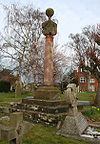
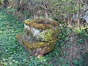
| Astbury churchyard cross |
Stone structure |
Newbold Astbury thumb|AstburyNewbold Astbury is a village and civil parish in the unitary authority of Cheshire East and the ceremonial county of Cheshire, in the north-west of England. It is situated to the south of Congleton on the A34 road to Scholar Green; the A34 forms one side of the triangular village green...
53.1508°N 2.2316°W |
MedievalThe Middle Ages is a periodization of European history from the 5th century to the 15th century. The Middle Ages follows the fall of the Western Roman Empire in 476 and precedes the Early Modern Era. It is the middle period of a three-period division of Western history: Classic, Medieval and Modern...
|
30394 |
The remains of a cross The Christian cross, seen as a representation of the instrument of the crucifixion of Jesus Christ, is the best-known religious symbol of Christianity...
which consists of an octagonal gritstoneGritstone or Grit is a hard, coarse-grained, siliceous sandstone. This term is especially applied to such sandstones that are quarried for building material. British gritstone was used for millstones to mill flour, to grind wood into pulp for paper and for grindstones to sharpen blades. "Grit" is...
base block standing on two octagonal steps in St Mary'sSt Mary's Church, Astbury, is an Anglican parish church in the village of Newbold Astbury, Cheshire, England. It has been designated by English Heritage as a Grade I listed building, and its architecture has been praised by a number of writers....
churchyard. At a later date a sundialA sundial is a device that measures time by the position of the Sun. In common designs such as the horizontal sundial, the sun casts a shadow from its style onto a surface marked with lines indicating the hours of the day. The style is the time-telling edge of the gnomon, often a thin rod or a...
shaft was added. The structure is listed Grade II. |
|
| Baddiley village |
Earthworks |
Baddiley Baddiley is a scattered settlement and civil parish in the unitary authority of Cheshire East and the ceremonial county of Cheshire, England. The civil parish also includes the north-western part of the village of Ravensmoor , as well as the small settlements of Baddiley Hulse, Batterley Hill, and...
53.0497°N 2.5863°W |
Late SaxonAnglo-Saxon is a term used by historians to designate the Germanic tribes who invaded and settled the south and east of Great Britain beginning in the early 5th century AD, and the period from their creation of the English nation to the Norman conquest. The Anglo-Saxon Era denotes the period of...
and medieval |
30389 |
A deserted settlement in a shallow valley to the east of Baddiley Hall Baddiley Hall is a country house in the settlement of Baddiley in Cheshire, England. Previously there was a half-timbered house on the site, but this had been replaced by the current house before the death of its owner, Sir Henry Mainwaring, in 1797. It is constructed in brown brick with a slate...
. There are signs of at least nine houses and barns on either side of small stream, which is now culvertA culvert is a device used to channel water. It may be used to allow water to pass underneath a road, railway, or embankment. Culverts can be made of many different materials; steel, polyvinyl chloride and concrete are the most common...
ed. The Shropshire Union CanalThe Shropshire Union Canal is a navigable canal in England; the Llangollen and Montgomery canals are the modern names of branches of the Shropshire Union system and lie partially in Wales....
runs through the eastern part of the site. |
|
| Barrow churchyard cross |
Standing stone |
Barrow Barrow is a civil parish containing the villages of Great Barrow, Little Barrow and Stamford Bridge. It is situated about east-north-east of Chester, north-west of Tarporley, and south of Frodsham.-See also:*St Bartholomew's Church, Barrow...
53.2093°N 2.7959°W |
Early 15th century |
30399 |
The remains of the cross consist of a square base of two steps and a tapering octagonal shaft. This was made into a sundial A sundial is a device that measures time by the position of the Sun. In common designs such as the horizontal sundial, the sun casts a shadow from its style onto a surface marked with lines indicating the hours of the day. The style is the time-telling edge of the gnomon, often a thin rod or a...
and it stands in the churchyard of St Bartholomew'sSt Bartholomew's Church, Barrow is in the village of Great Barrow in the civil parish of Barrow, Cheshire, England. It has been designated by English Heritage as a Grade II* listed building...
. It is listed Grade II. |
|
| Barrow Old Hall moated site |
Earthwork |
Great SankeyGreat Sankey is a civil parish and suburban area of the Borough of Warrington and the ceremonial county of Cheshire in England. It is west of Warrington town centre. It has a population of 24,211.-History:...
53.4013°N 2.6605°W |
Medieval |
13434 |
This originally contained a timber framedTimber framing , or half-timbering, also called in North America "post-and-beam" construction, is the method of creating structures using heavy squared off and carefully fitted and joined timbers with joints secured by large wooden pegs . It is commonplace in large barns...
house dating back to at least 1330. Subsequently occupied by newer houses, it is now empty, and consists of a platform surrounded by a moat which is water-filled in three sides with a bridge crossing the western arm. Partial excavations took place in 1986–87 and 1995. |
|
Beeston CastleBeeston Castle is a former Royal castle in Beeston, Cheshire, England , perched on a rocky sandstone crag above the Cheshire Plain. It was built in the 1220s by Ranulf de Blondeville, 6th Earl of Chester, , on his return from the Crusades...
|
Castle ruins |
Beeston Beeston is a village and civil parish in the unitary authority of Cheshire West and Chester and the ceremonial county of Cheshire in the north of England. It is south of Tarporley, and close to the Shropshire Union Canal. Beeston Castle nearby is a spectacular clifftop ruin in the care of English...
53.1280°N 2.6919°W |
1220 and later |
23641 |
A medieval castle built on a previous hillfort. Building started in the 1220s and it was occupied by Simon de MontfortSimon de Montfort, 6th Earl of Leicester, 1st Earl of Chester , sometimes referred to as Simon V de Montfort to distinguish him from other Simon de Montforts, was an Anglo-Norman nobleman. He led the barons' rebellion against King Henry III of England during the Second Barons' War of 1263-4, and...
in the Second Barons' WarThe Second Barons' War was a civil war in England between the forces of a number of barons led by Simon de Montfort, against the Royalist forces led by Prince Edward , in the name of Henry III.-Causes:...
. It was extended in the 13th and 14th centuries but by the 16th century had become a ruin, although it was involved in the Civil WarThe English Civil War was a series of armed conflicts and political machinations between Parliamentarians and Royalists...
. The medieval ruins are listed Grade I. |
|
| Belgrave moated site |
Earthworks |
Eaton
53.1384°N 2.9126°W |
Medieval |
13462 |
Formerly a manor house with a moat which was flanked on three sides by a medieval garden. By the early 17th century it was part of the Eaton estate and used as coppice Coppicing is a traditional method of woodland management which takes advantage of the fact that many trees make new growth from the stump or roots if cut down. In a coppiced wood, young tree stems are repeatedly cut down to near ground level...
woodland. |
|
| Belmont moat |
Moat |
Great BudworthGreat Budworth is a civil parish and village, approximately north of Northwich, England, within the unitary authority of Cheshire West and Chester and the ceremonial county of Cheshire. It lies off the A559 road, east of Comberbach, northwest of Higher Marston and southeast of Budworth Heath...
53.3016°N 2.5159°W |
Medieval |
13496 |
Formerly a grange of Norton PrioryNorton Priory is a historic site in Norton, Runcorn, Cheshire, England, comprising the remains of an abbey complex dating from the 12th to 16th centuries, and an 18th-century country house; it is now a museum. The remains are a scheduled ancient monument and have been designated by English...
. Now consists of a water-filled moat enclosing a five-sided platform with a causewayIn modern usage, a causeway is a road or railway elevated, usually across a broad body of water or wetland.- Etymology :When first used, the word appeared in a form such as “causey way” making clear its derivation from the earlier form “causey”. This word seems to have come from the same source by...
on the west side. |
|
| Bewsey Old Hall moated site |
Moat, fishpond and building platform |
BurtonwoodBurtonwood and Westbrook is a civil parish in the outermost suburbs of Warrington in Cheshire, England. Historically within Lancashire, the name Burtonwood is known worldwide as the location of the former RAF Station Burtonwood military camp. Burtonwood village itself is a few miles away from the...
53.4014°N 2.6171°W |
Medieval |
13488 |
Originally a grange, then a moated manor house. The moat, fishpond and the building platform are scheduled. Bewsey Old Hall stands on the platform. |
|
| Bostock Hall moat |
Earthworks |
WinsfordWinsford is a town and civil parish within the unitary authority of Cheshire West and Chester and the ceremonial county of Cheshire, England. It lies on the River Weaver south of Northwich and west of Middlewich, and grew around the salt mining industry after the river was canalised in the...
53.2020°N 2.4862°W |
Medieval |
13495 |
A rectangular waterlogged moat with an overgrown platform and a causeway. |
|
| Bradlegh Old Hall moated site |
Moated site, gatehouse and fishpond |
BurtonwoodBurtonwood and Westbrook is a civil parish in the outermost suburbs of Warrington in Cheshire, England. Historically within Lancashire, the name Burtonwood is known worldwide as the location of the former RAF Station Burtonwood military camp. Burtonwood village itself is a few miles away from the...
53.4399°N 2.6463°W |
Medieval |
13479 |
A 15th century moated hall. The moat, the fortified gatehouseA gatehouse, in architectural terminology, is a building enclosing or accompanying a gateway for a castle, manor house, fort, town or similar buildings of importance.-History:...
and a fishpond remain. A later farmhouse now stands on the platform. |
|
| Bradley Green Bradley Green is a deserted medieval village in Cheshire, England, located at . The site, which aerial photography has shown to have small house platforms and a former road, is a Scheduled Ancient Monument....
|
Earthworks |
Bradley
53.0086°N 2.7386°W |
Medieval |
30390 |
A medieval village now deserted. Aerial photography has shown small house platforms and a former road. |
|
| Bradley Hall moated site |
Earthworks |
Appleton, Warrington
53.3565°N 2.5166°W |
Medieval |
13447 |
A former moated manor house. Most of the platform is now occupied by a more modern farmhouse and garden. |
|
| Bruera churchyard cross |
Stone structure |
Bruera
53.1392°N 2.8419°W |
Medieval |
32561 |
This consists of the base and part of the shaft of a former standing cross, later converted into a sundial in churchyard of St Mary'sSt Mary's Church, Bruera is in the small settlement of Bruera, which lies between the villages of Saighton and Aldford, in Cheshire, England. It has been designated by English Heritage as a Grade II* listed building. The church contains Norman elements, but it has been subjected to...
|
|
| Bruera moat and field system |
Earthworks |
Buerton Buerton is a civil parish in the unitary authority of Cheshire West and Chester and the ceremonial county of Cheshire, England. According to the 2001 census it had a population of 22....
53.1395°N 2.8425°W |
Medieval |
13442 |
A former moated manor house surrounded by an enclosure which is subdivided into smaller enclosures forming a field systemThe study of field systems in landscape history is concerned with the size, shape and orientation of a number of fields. These are often adjacent, but may be separated by a later feature.-Types of field system:...
. |
|
| Capesthorne Hall and chapel |
Earthworks |
Siddington Siddington is a civil parish in the unitary authority of Cheshire East and the ceremonial county of Cheshire, England. It consists of farms, a picnic site, Redesmere, a half-mile long lake, and the Capesthorne Estate. The village is located at the crossroads of the A34 with the B5392 approximately...
53.2497°N 2.2367°W |
Medieval |
30393 |
The platform of the former chapel is marked by a 20th century memorial pillar. To the southeast are earthworks remaining from the old hall. |
|
| Castle Cob motte |
Earthworks |
Manley right|thumb|200px|Map of civil parish of Manley within the former borough of Vale RoyalManley is a village and civil parish in the unitary authority of Cheshire West and Chester and the ceremonial county of Cheshire, in the north west of England.-External links:...
53.2558°N 2.6998°W |
Medieval |
22595 |
A steep-sided motte with no signs of a bailey, 23m in diameter and 2.8m high. An excavation found only black soil. |
|
| Castle Hill |
Earthworks |
Malpas Malpas is a large village which used to be a market town, and it is also a civil parish in the unitary authority of Cheshire West and Chester and the ceremonial county of Cheshire, England. The parish lies on the border with Shropshire and Wales...
53.0200°N 2.7672°W |
Medieval |
13420 |
A mound which formerly held the keep of the castle of the Barons of Malpas. There is no sign of a bailey or a ditch. The church of St Oswald lies within the castle precinct. |
|
| Castle Hill system |
Earthworks |
Oldcastle
52.9918°N 2.7935°W |
Medieval |
13421 |
Tree-felling in 1957 on a spur overlooking Wych Brook The Wych Brook or Red Brook, formerly known as the River Elfe, is a small river in the north-west midlands of the United Kingdom. It forms both the historic and present-day border between England and Wales...
revealed a motte with a defensive ditch system on the England-Wales border. |
|
| Castletown Castletown in the parish of Shocklach, in Cheshire, England is a deserted village located at whose sole remains are earthworks. The site is a Scheduled Ancient Monument....
deserted village |
Earthworks |
Shocklach Shocklach is a village in the civil parishes of Church Shocklach and Shocklach Oviatt, Cheshire, England.St Edith's Church, Shocklach is a Grade I listed building.-External links:...
53.0558°N 2.8376°W |
Medieval |
30391 |
A series of earthworks indicating a deserted villageAn abandoned village is a village that has, for some reason, been deserted. In many countries, and throughout history, thousands of villages were deserted for a variety of causes...
|
|
| Cheersgreen Farm dam and millpond |
Earthwork and pond |
Peover Superior Peover Superior is a civil parish in the unitary authority of Cheshire East and the ceremonial county of Cheshire, England.It contains the village of Over Peover and Peover Hall. St Lawrence's Church, Over Peover is a Grade I listed building....
52.2590°N 2.3718°W |
Mid 15th century |
30376 |
The pool was abandoned around 1750 and reinstated in 1977 |
|
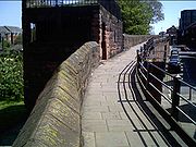
| Chester city walls .Chester city walls consist of a defensive structure built to protect the city of Chester in Cheshire, England. Their construction was started by the Romans when they established the fortress of Deva Victrix between 70 and 80 AD. It originated with a rampart of earth and turf surmounted by a...
|
City walls |
Chester
53.1923°N 2.8891°W |
Roman and medieval |
CH7 |
These consist of an almost complete circuit round the city, 2 miles (3 km) long, including four gates and several towers linked by a red sandstone wall. The north and east walls follow the Roman foundations, while the south and west walls were extended in the medieval period. |
|
| Chorley Old Hall Chorley Old Hall is a moated manor house on the A535 road to the southwest of Alderley Edge, Cheshire, England. The house has been designated by English Heritage as a Grade I listed building, and the moated site is a scheduled monument...
moat and fishponds |
Moat and fishponds |
Alderley EdgeAlderley Edge is a village and civil parish within the unitary authority of Cheshire East and the ceremonial county of Cheshire, England. According to the 2001 census the parish had a population of 4,409....
53.2994°N 2.2453°W |
Medieval |
13497 |
The moated site and three associated fishponds are scheduled. The site contains a house in two ranges, one built about 1330 and the other in the mid-16th century. |
|
| Cranshaw Hall moated site |
Earthworks |
WidnesWidnes is an industrial town within the borough of Halton, in Cheshire, England, with an urban area population of 57,663 in 2004. It is located on the northern bank of the River Mersey where the estuary narrows to form the Runcorn Gap. Directly to the south across the Mersey is the town of Runcorn...
53.3936°N 2.7272°W |
Medieval |
13480 |
The site is mainly covered by newer buildings but the west arm of the moat can be traced on the lawn. |
|
| Darley Hall moated site |
Earthworks |
Little Budworth thumb|right|200px|Map of civil parish of Little Budworth within the former borough of Vale RoyalLittle Budworth is a civil parish and village between Winsford and Chester, in the unitary authority of Cheshire West and Chester and the ceremonial county of Cheshire, England...
53.1740°N 2.5893°W |
Medieval |
23638 |
A rectangular moated platform formerly occupied by Darley Old Hall. The moat is waterlogged and in good condition on three sides. There is now no evidence of a previously recorded drawbridgeA drawbridge is a type of movable bridge typically associated with the entrance of a castle surrounded by a moat. The term is often used to describe all different types of movable bridges, like bascule bridges and lift bridges.-Castle drawbridges:...
. |
|
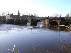
| Dee Bridge |
Bridge |
Chester
53.1855°N 2.8887°W |
14th century |
CH17 |
A sandstone bridge of seven arches crossing the River DeeThe River Dee is a long river in the United Kingdom. It travels through Wales and England and also forms part of the border between the two countries....
. It was widened in 1826 and is a Grade I listed building. |
|
| Denhall hospital and limekiln |
Earthworks and ruined walls |
Neston
53.2651°N 3.0486°W |
c. 1231–34 |
23645 |
Site of St Andrew's Hospital, a monastic hospital for travellers to Ireland; dissolved in 1496. Later occupied by a parsonage which was demolished in 1738. Now consists of earthworks and parts of ruined buildings; also present are the remains of a limekiln. |
|
| Dodleston Castle |
Earthworks |
Dodleston Dodleston is a village and civil parish in the unitary authority of Cheshire West and Chester and the ceremonial county of Cheshire, situated on the border between England and Wales...
53.1411°N 2.9563°W |
Medieval |
13501 |
The flat-topped motte is 3.3m high and the bailey is well-defined. |
|
| Dodleston Hall moated site |
Moat |
Dodleston
53.1467°N 2.9559°W |
Medieval |
13455 |
A moated site formerly occupied by Dodleston Hall. The moat is almost complete other than the southeast corner which is covered by buildings. |
|
| Drakelow Hall moated site |
Moat and fishponds |
Byley right|thumb|200px|Map of civil parish of Byley within the former borough of Vale RoyalByley is a village and civil parish in the unitary authority of Cheshire West and Chester and the ceremonial county of Cheshire, England, about 2½ miles north of Middlewich....
53.2273°N 2.4443°W |
Medieval |
13441 |
A rectangular moat with a further moated site to the southwest and four fishponds to the northwest. |
|
| Eccleston motte |
Earthworks |
EcclestonEccleston is a civil parish and village in the unitary authority of Cheshire West and Chester and the ceremonial county of Cheshire, and close to Chester...
53.1584°N 2.8800°W |
Medieval (probable) |
22591 |
An oval mound scheduled as a motte; it is partly surrounded by a ditch and banks. |
|
| Edleston moated site |
Earthworks |
Edleston Edleston is a civil parish in the unitary authority of Cheshire East and the ceremonial county of Cheshire, England, which lies immediately to the south west of Nantwich. For administrative purposes, it is combined with adjacent civil parishes of Acton and Henhull to form a total area of 765 hectares...
53.0529°N 2.5415°W |
Medieval |
13518 |
A rectangular platform 50m x 30m surrounded by a dry moat with a ditch to the west and south. |
|
| Elton moated site |
Earthworks |
Elton Elton is a village and civil parish in the unitary authority of Cheshire West and Chester and the ceremonial county of Cheshire, England. It is situated approximately to the northeast of Chester, between Helsby and Ellesmere Port, near to the River Mersey. Its proximity to the River Mersey and...
53.2675°N 2.8181°W |
Medieval |
13436 |
An almost square moat with a causeway across the north arm and a channel at the northwest corner leading to a fishpond. |
|
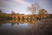
Farndon BridgeFarndon Bridge crosses the River Dee and the England-Wales border between the villages of Farndon, Cheshire, England and Holt, Wales . It has been designated by English Heritage as a Grade I listed building, and is a scheduled monument...
|
Bridge |
FarndonFarndon is a village and civil parish in the unitary authority of Cheshire West and Chester and the ceremonial county of Cheshire, England. It is located on the banks of the River Dee, south of Chester, and close to the border with Wales...
53.0836°N 2.8798°W |
c. 1345 |
CH124 |
A bridge crossing the River Dee and the England-Wales border leading from Farndon to HoltHolt is a medieval market town and local government community in the county borough of Wrexham, Wales. It is situated on the border with England. Holt Castle was begun by Edward I shortly after the English invasion of Wales in 1277.-Area:...
. It is listed Grade I. |
|
| Farnworth churchyard cross |
Stone structure |
FarnworthFarnworth is part of the town of Widnes which is in the Borough of Halton in the ceremonial county of Cheshire, England. It was a village in south Lancashire between Prescot and Penketh...
, WidnesWidnes is an industrial town within the borough of Halton, in Cheshire, England, with an urban area population of 57,663 in 2004. It is located on the northern bank of the River Mersey where the estuary narrows to form the Runcorn Gap. Directly to the south across the Mersey is the town of Runcorn...
53.3842°N 2.7275°W |
Medieval |
25704 |
This consists of a medieval base and plinth In architecture, a plinth is the base or platform upon which a column, pedestal, statue, monument or structure rests. Gottfried Semper's The Four Elements of Architecture posited that the plinth, the hearth, the roof, and the wall make up all of architectural theory. The plinth usually rests...
with a 19th century shaft in St Luke'sSt Luke's Church, Farnworth, Widnes, is a parish church in Farnworth, which was once a separate village but which is now part of the town of Widnes, Cheshire, England). The church dates back to the 12th century and it contains a number of items of historical interest, in particular hatchments...
churchyard. |
|
| Fir Tree Farm moated site |
Earthworks |
Chester
53.1651°N 2.9094°W |
Medieval |
13451 |
This consists of a dry moat enclosing an area 15m wide with a bank and ditch in the west and south. |
|
| Foulk Stapleford moated site |
Earthworks |
Foulk Stapleford Foulk Stapleford is a civil parish in the unitary authority of Cheshire West and Chester and the ceremonial county of Cheshire, England.It contains the village of Hargrave. St Peter's Church, Hargrave is a Grade II* listed building....
53.1714°N 2.7723°W |
Medieval |
13457 |
A square moat with rounded corners; River Gowy The River Gowy is a river in Cheshire, England and a tributary of the River Mersey.It rises in western Cheshire in the hills near Peckforton Castle, very close to the source of the River Weaver. While the Weaver flows south initially, the Gowy flows north and for several miles provides the valley...
is to the west and a disused mill raceA mill race, raceway or mill lade is the current or channel of a stream, especially one for conducting water to or from a water wheel or other device for utilizing its energy...
to the east. |
|
| Foxtwist moated site |
Earthworks |
PrestburyPrestbury is a village, civil parish and ecclesiastical parish in the unitary authority of Cheshire East and the ceremonial county of Cheshire, England. Prestbury is a long, narrow parish covering 1,165 hectares to the west of the Peak Park foothills and to the east of the sandstone ridge which is...
53.3152°N 2.1570°W |
Medieval |
13448 |
The remains of a deep inner moat that enclosed a raised platform which is accessed by a causewayIn modern usage, a causeway is a road or railway elevated, usually across a broad body of water or wetland.- Etymology :When first used, the word appeared in a form such as “causey way” making clear its derivation from the earlier form “causey”. This word seems to have come from the same source by...
|
|
| Gawsworth churchyard cross |
Stone structure |
Gawsworth Gawsworth is a civil parish and village in the unitary authority of Cheshire East and the ceremonial county of Cheshire, England. It is one of the eight ancient parishes of Macclesfield Hundred. Twenty acres of the civil parish were transferred to Macclesfield civil parish in 1936The country houses...
53.2240°N 2.1660°W |
15th century |
30365 |
This consists of a square cross-base and an octagonal shaft on a stepped plinth In architecture, a plinth is the base or platform upon which a column, pedestal, statue, monument or structure rests. Gottfried Semper's The Four Elements of Architecture posited that the plinth, the hearth, the roof, and the wall make up all of architectural theory. The plinth usually rests...
in the churchyard of St James'St James' Church, Gawsworth, is in the village of Gawsworth, Cheshire, England, and is sited near Gawsworth Hall. It has been designated by English Heritage as a Grade I listed building. It is an active Anglican parish church in the diocese of Chester, the archdeaconry of Macclesfield and...
. There are carvings of beasts at the corners of the plinth. It is listed Grade II. |
|
| Gawsworth roadside cross |
Stone structure |
Gawsworth
53.2310°N 2.1688°W |
Medieval |
25707 |
It consists of consists of a plinth of dressed gritstone blocks rising to two steps which is surmounted by a gritstone block cut into two steps with a fragment of shaft. It was the base for a preaching cross A preaching cross is a cross, sometimes surmounting a pulpit, erected out of doors to designate a preaching place.In Britain and Ireland, many free-standing upright crosses – or high crosses – were erected. Some of these crosses bear figurative or decorative carvings, or inscriptions in runes...
. |
|
| Glaziers Hollow |
Glass works |
Delamere Forest Delamere Forest or Delamere Forest Park is a wood in the Cheshire West and Chester area of Cheshire, England, near the town of Frodsham. It includes of mixed deciduous and evergreen woodland, centred at around , making it the largest area of woodland in Cheshire...
53.2464°N 2.7007°W |
15th–16th century |
33880 |
The probable site of a medieval wood-burning glass furnace which was discovered in 1933. It was excavated in 1933–35 and again in 1947. |
|
| Golden Stone |
Boulder |
Nether Alderley Nether Alderley is a village and civil parish in the unitary authority of Cheshire East and the ceremonial county of Cheshire, England. It lies on the A34 road about a mile and a half south of Alderley Edge....
Over Alderley
53.2942°N 2.2069°W |
Medieval |
33860 |
A large boulder which acted as a boundary marker A boundary marker, boundary stone or border stone is a robust physical marker that identifies the start of a land boundary or the change in a boundary, especially a change in a direction of a boundary...
between the estates of the Stanley and De Trafford families. |
|
| Grafton |
Earthworks |
Grafton
53.0563°N 2.8243°W |
Medieval |
13517 |
Evidence of several ditched enclosures shown by aerial photography which are overlain by an ornamental moat. These probably represent a deserted village. |
|
| Great Merestone |
Boulder |
Finlow Hill
53.2847°N 2.2107°W |
Medieval |
33862 |
A stone 1.3m in diameter and 0.4m high marking the boundary between Nether Alderley and Over Alderley. |
|
| Hall Bank moated site |
Earthworks |
WybunburyWybunbury is a village and civil parish in the unitary authority of Cheshire East and the ceremonial county of Cheshire, England. The village lies 3¼ miles to the south east of Nantwich and 3¾ miles to the south of Crewe. The parish also includes the settlements of Clannor Heath, Daisy Hill, The...
53.0451°N 2.4448°W |
Medieval |
13438 |
Earthworks of a square moat and a causeway leading towards the church |
|
Halton CastleHalton Castle is in the former village of Halton which is now part of the town of Runcorn, Cheshire, England. The castle is situated on the top of Halton Hill, a sandstone prominence overlooking the village...
|
Ruined castle |
Halton Halton, formerly a separate village, is now part of the town of Runcorn, Cheshire, England. The name Halton has been assumed by the Borough of Halton, which includes Runcorn, Widnes and some outlying parishes.-Geography:...
53.3331°N 2.6957°W |
c. 1070 and later |
27611 |
Ruins of a castle which was involved in the Civil WarThe English Civil War was a series of armed conflicts and political machinations between Parliamentarians and Royalists...
and then partly demolished. |
|
| Harthill Bank Castle |
Earthworks |
Oakmere
53.2423°N 2.6511°W |
Medieval |
13453 |
An earthwork which is scheduled as a motte and bailey. |
|
| Hatton Hall moated site |
Earthwork |
Hatton
53.1440°N 2.7907°W |
Medieval |
13456 |
A square moat, largely water-logged, which formerly enclosed Hatton Hall. |
|
| Haycroft medieval village Haycroft, near Spurstow, in Cheshire, England is a deserted village located at . Aerial photography has shown evidence of a medieval village and a field system. The site is a Scheduled Ancient Monument....
|
Earthworks |
Spurstow Spurstow is a village and civil parish in the unitary authority of Cheshire East and the ceremonial county of Cheshire, England, which is located 6½ miles to the north west of Nantwich. The parish also includes the settlement of Spurstow Sketh and part of Radmore Green. Nearby villages include...
53.1108°N 2.6660°W |
Medieval |
30388 |
Aerial photography has revealed evidence of a medieval village and a field system. |
|
| Headless Cross |
Stone |
Oakmere
53.2066°N 2.6252°W |
Medieval |
25697 |
This consists of the stone socket for a cross. The shaft is missing. |
|
| Holford Hall Holford Hall is a country house standing to the west of the village of Plumley, Cheshire, England. It consists of a fragment of a much larger timber-framed house, built in 1601 for Mary Cholmondeley on a moated site. Part of the building was demolished in the 1880s. The house is timber-framed...
moated site |
Earthworks |
Plumley Plumley is a village and civil parish in the unitary authority of Cheshire East and the ceremonial county of Cheshire, England.In the village there are two public houses, The Golden Pheasant and The Smoker , a village hall, a Methodist church, tennis courts, riding stables, a post office and a golf...
53.2751°N 2.4377°W |
Medieval |
13498 |
An almost complete waterlogged moat accessed by a stone bridge and a causeway. The platform is occupied by a 17th century farmhouse |
|
| Hough Hall moated site |
Earthworks |
Mere Mere is a civil parish and linear village along the A556 road in the unitary authority of Cheshire East and the ceremonial county of Cheshire, North West England, about south-west of Altrincham. Bucklow Hill is at its northeast end, and the Mere crossroads is at the far end. The village of Mere is...
53.3464°N 2.4195°W |
Medieval |
13478 |
A platform surrounded by a dry moat, with two small fishponds and a dam. |
|
| Hulme Hall Hulme Hall is a house on a moated site in the parish of Allostock, Cheshire, England. It originated in the 15th century, with additions and alterations in the 17th and 19th centuries. It is now a farmhouse. The house is constructed in brown brick, and has a roof of stone-slate and...
moated site |
Moat |
Allostock thumb|right|200px|Map of Allostock civil parish within the former borough of Vale RoyalAllostock is a village and civil parish in the unitary authority of Cheshire West and Chester and the ceremonial county of Cheshire, England, about five miles south of Knutsford. It has a population of 783...
53.2478°N 2.4139°W |
Medieval |
13491 |
The moat and the ground beneath the bridge and the hall are scheduled. |
|
| Huntington Hall moated site |
Earthworks |
Huntington
53.1651°N 2.8692°W |
Medieval |
13416 |
Site of moated manor house |
|
| Huntington Hall moated site (south) |
Earthworks |
Huntington
53.1520°N 2.8545°W |
Medieval |
13417 |
A square platform surrounded by a bank. |
|
| Iddinshall moat |
Moat |
Tarporley
53.1594°N 2.6979°W |
Medieval |
13459 |
A large moat, now dry, surrounding an area of 4 acres (1.6 ha) on which Iddinshall Hall stood. |
|
| Ince Manor Ince Manor or Ince Grange is a former monastic grange in the village of Ince in Cheshire, England. The remains of the manor house, consisting of the old hall, and the monastery cottages have been designated by English Heritage as a Grade I listed building, and a scheduled monument...
|
Buildings and earthworks |
InceInce is a village and civil parish in the unitary authority of Cheshire West and Chester and the ceremonial county of Cheshire, England. It is situated immediately to the east of the Stanlow Oil Refinery. It shares Ince and Elton railway station with the village of Elton, which it runs into...
53.2830°N 2.8271°W |
13th–14th century |
13516 |
Formerly a monastic grange. There are also earthworks from a possible moat and a fishpool and portions of a boundary wall. The former hall and domestic range were restored in the 2000s. The hall is listed Grade I. |
|
| Jarman Farm moated site |
Earthworks |
Sutton Lane Ends Sutton Lane Ends or Sutton is a semi-rural village and civil parish that is situated roughly a mile south of Macclesfield; it includes the hamlets of Gurnett and Jarman. Sutton is in the unitary authority of Cheshire East and the ceremonial county of Cheshire, England...
53.2407°N 2.1053°W |
Medieval |
13514 |
A curving ditched enclosure comprising one-third of a former moat. It is the only circular medieval moated site in Cheshire. |
|
| Kinderton Hall moat and fishponds |
Earthworks |
Kinderton Kinderton is an electoral ward in Middlewich, Cheshire, England. Kinderton was also historically the name of a township in Middlewich on the opposite side of the River Croco from the current ward....
53.1995°N 2.4392°W |
Medieval |
13492 |
Earthworks of a former moat and fishponds. |
|
| Knutsford chapel |
Stone slabs |
Knutsford Knutsford is a town and civil parish in the unitary authority area of Cheshire East and the ceremonial county of Cheshire, in North West England...
53.3053°N 2.3529°W |
Early 14th century |
25728 |
A chapel originally dedicated to St Helena, later to St John, stood on the site and was demolished in 1741 |
|
| Lea Hall moat |
Moat |
Near Aldford
53.1239°N 2.8503°W |
Medieval |
30379 |
A moated site 52m x 43m formerly containing Lea Hall, the middle arm of which has been filled in. |
|
Little Moreton HallLittle Moreton Hall is a moated 15th and 16th-century half-timbered manor house southwest of Congleton, Cheshire. It is one of the finest examples of timber-framed domestic architecture in England. The house is today owned by the National Trust. It has been designated by English Heritage as a...
|
Building, moat and garden |
Odd Rode Odd Rode is a civil parish in the unitary authority of Cheshire East and the ceremonial county of Cheshire, England. It is located near to Stoke-on-Trent, and includes the settlements of:*Scholar Green*Mow Cop*Mount Pleasant*Rode Heath*The Bank*Thurlwood...
53.1271°N 2.2522°W |
15th century |
13472 |
A timber framedTimber framing , or half-timbering, also called in North America "post-and-beam" construction, is the method of creating structures using heavy squared off and carefully fitted and joined timbers with joints secured by large wooden pegs . It is commonplace in large barns...
manor house and remains of an ElizabethanThe Elizabethan era was the epoch in English history of Queen Elizabeth I's reign . Historians often depict it as the golden age in English history...
formal garden. The hall is listed Grade I. |
|
| Longstone |
Stone structure |
Little Budworth thumb|right|200px|Map of civil parish of Little Budworth within the former borough of Vale RoyalLittle Budworth is a civil parish and village between Winsford and Chester, in the unitary authority of Cheshire West and Chester and the ceremonial county of Cheshire, England...
53.2047°N 2.6160°W |
Medieval |
25696 |
Part of a medieval cross shaft set on modern base at a junction of a road leading to Vale Royal AbbeyVale Royal Abbey is a medieval abbey, and later country house, located in Whitegate, between Northwich and Winsford in Cheshire, England.The abbey was founded in 1270 by Edward I for monks of the austere Cistercian order...
. It is listed Grade II. |
|
| Longstone Lane wayside cross |
Stone |
Little Budworth
53.2055°N 2.6203°W |
Medieval |
25698 |
It consists of a square stone with a hollowed top on a 19th century plinth, thought to have been a wayside cross and also a plague stone. It is listed Grade II. |
|
| Lovel's Hall moated site |
Earthworks |
Halebank Halebank is a civil parish in the borough of Halton, Cheshire, England. It was created by the Halton Order 2008. The parish lies in the western part of the town of Widnes.-References:...
53.3574°N 2.7846°W |
Medieval |
13435 |
A square moated platform with a dry ditch formerly occupied by Lovel's Hall. |
|
| Lower Huxley Hall Lower Huxley Hall is a moated manor house in Cheshire, England, located about 6.5 miles southeast of Chester. It lies roughly halfway between the villages of Huxley and Hargrave , It dates from the late 15th century, with major additions and alterations in the 17th century. A small...
moated site |
Moat and platform |
Huxley
53.1551°N 2.7524°W |
Medieval |
13458 |
A water-filled moat. partly lined with sandstone, with a platform now occupied by the 15th-century Lower Huxley Hall and its gardens. |
|
| Lymm Hall -History:The house was built in the 17th century for the Domville family. In the 18th or early 19th century, wings were added. In about 1840, stepped gables and mullioned windows were installed, resulting in a symmetrical front in neo-Jacobean style...
moat and ice house |
Earthworks |
Lymm Lymm is a large village and civil parish within the Warrington borough of Cheshire, in North West England. Lymm was an urban district of Cheshire from 1894 to 1974. The civil parish of Lymm incorporates the hamlets of Booths Hill, Broomedge, Church Green, Deansgreen, Heatley, Heatley Heath, Little...
53.3793°N 2.4759°W |
Medieval |
23639 |
Site of a moated medieval manor house with its ice house on a mound to the west. A later house has been built on the moated platform and a modern summer house on the site of the ice house. |
|
| Maiden's Cross |
Stone |
Alvanleyright|thumb|200px|Map of civil parish of Alvanley within the former borough of [[Vale Royal]].Alvanley is a small rural village and civil parish near the village of Helsby, in the unitary authority of Cheshire West and Chester and the ceremonial county of Cheshire, England...
53.2568°N 2.7294°W |
Medieval |
25711 |
A trapezoidal piece of sandstone with a chamber on the front face. Possibly the base of a wayside cross or a plague cross. It is listed Grade II. |
|
| Malpas Cross |
Stone structure |
Malpas
53.0201°N 2.7655°W |
Medieval |
25710 |
The cross has a medieval octagonal base of seven steps. The rest of the cross was added in 1873. It is listed Grade II. |
|
| Marton churchyard cross |
Standing stone |
Marton Marton, Cheshire is a small village and civil parish in the unitary authority of Cheshire East and the ceremonial county of Cheshire, England on the A34 road 3 miles north of Congleton ....
53.2087°N 2.2255°W |
Medieval |
30364 |
This consists of the broken shaft of a cross on a stepped plinth in the churchyard of St James' & St Paul'sThe Church of St James and St Paul, Marton is situated to the south of the village of Marton, Cheshire, England. It has been designated by English Heritage as a Grade I listed building. It is an active Anglican parish church in the diocese of Chester, the archdeaconry of Macclesfield and the...
. It is listed Grade II. The rest of the shaft is in the church. |
|
| Marton Grange moated site |
Earthworks |
Marton
53.2036°N 2.5662°W |
Medieval |
13519 |
A moated site which contained a monastic grange which is accessed by a bridge with associated fishponds. The site includes the mutilated socket stone of a sandstone cross. |
|
| Merricks Hill chamber |
Foundations |
Delamere
53.2183°N 2.6688°W |
c. 1354 |
25692 |
The foundations of a hunting lodge and administrative centre for the Royal Forest of Delamere Delamere Forest or Delamere Forest Park is a wood in the Cheshire West and Chester area of Cheshire, England, near the town of Frodsham. It includes of mixed deciduous and evergreen woodland, centred at around , making it the largest area of woodland in Cheshire...
on Eddisbury Hill. |
|
| Middleton Grange moated site |
Earthworks |
Aston right|thumb|200px|Map of civil parish of Aston within the former borough of Vale RoyalAston is a village and civil parish in the unitary authority of Cheshire West and Chester and the ceremonial county of Cheshire, England. According to the 2001 census it had a population of 111...
53.2883°N 2.6674°W |
Medieval |
13515 |
A moated site with eight fishponds and connecting channels. It was originally a monastic grange and later the site of Middleton Hall and a chapel. |
|
| Mill Hill House Farm moat |
Moat |
Eccleston
53.1567°N 2.8974°W |
Medieval |
13418 |
A square moat about 80m across, grass-covered and normally dry. |
|
| Minshull Vernon moated site |
Earthworks |
Minshull Vernon Minshull Vernon is a hamlet and civil parish in the unitary authority of Cheshire East and the ceremonial county of Cheshire, England. The hamlet lies to the north west of Crewe, south east of Winsford and south west of Middlewich. The parish also includes the small settlements of Bradfield Green,...
53.1389°N 2.4662°W |
Medieval |
13440 |
A complete double moat, the external moat being dry and the inner one water-filled. A dry fishpond connects to the outer moat. |
|
| Mobberley churchyard cross |
Stone structure |
Mobberley Mobberley is a semi-rural village and civil parish in the unitary authority of Cheshire East and the ceremonial county of Cheshire, situated between Wilmslow and Knutsford. Mobberley railway station lies on the Manchester to Northwich and Chester line and was opened on 12 May, 1862 by the Cheshire...
53.3183°N 2.3161°W |
Medieval |
30397 |
This consists of a stone cross base and part of cross shaft in the churchyard of St Wilfrid'sSt Wilfrid's Church, Mobberley stands to the north of the village of Mobberley, Cheshire, England. The church has been designated by English Heritage as a Grade I listed building. It is an active Anglican parish church in the diocese of Chester, the archdeaconry of Macclesfield and the...
. It is listed Grade II. |
|
| Monks Lane moated site |
Moat and platform |
Acton
53.0743°N 2.5549°W |
Medieval |
13437 |
Square platform 10m wide surrounded by a water-filled moat. |
|
| Nether Alderley churchyard cross |
Stone structure |
Nether Alderley
53.2818°N 2.2390°W |
Medieval |
30363 |
The base is square below and shaped to octagonal above into which a rectangular shaft is set. It stands in St Mary'sSt Mary's Church, Nether Alderley, is an Anglican church at the end of a lane to the south of the village of Nether Alderley, Cheshire, England. It dates from the 14th century, with later additions and a major restoration in the late-19th century...
churchyard and is listed Grade II. |
|
| Nether Alderley village cross |
Stone structure |
Nether Alderley
53.2891°N 2.2362°W |
Medieval |
25708 |
Built in buff and red sandstone, this consists of a massive square base on which are three steps and a cube-shaped block. Into this is set a broken rectangular shaft. It is listed Grade II. |
|
| New Manor Farm moated site |
Earthworks |
Preston Brook Preston Brook is a civil parish in the borough of Halton, a unitary authority in the ceremonial county of Cheshire, England. It is located to the south-east of Runcorn and is adjacent to the M56 motorway. It contains the villages of Preston Brook and Preston on the Hill.In the 2001 Census, the...
53.3188°N 2.6311°W |
Medieval |
13483 |
A rectangular platform surrounded by a water-filled moat on which is a modern farmhouse. |
|
| Norbury Booths Hall moated site |
Moat and earthworks |
Knutsford
53.2981°N 2.3467°W |
Medieval |
13449 |
The largest moat in Cheshire, partly water-filled. A stone chamber outside the moat, which was formerly a cess-pit A cesspit, or cesspool is a pit, conservancy tank, or covered cistern, which can be used to dispose of urine and feces, and more generally of all sewage and refuse. It is a more antiquated solution than a sewer system. Traditionally, it was a deep cylindrical chamber dug into the earth, having...
, is linked by a stone-lined culvertA culvert is a device used to channel water. It may be used to allow water to pass underneath a road, railway, or embankment. Culverts can be made of many different materials; steel, polyvinyl chloride and concrete are the most common...
. |
|
Norton PrioryNorton Priory is a historic site in Norton, Runcorn, Cheshire, England, comprising the remains of an abbey complex dating from the 12th to 16th centuries, and an 18th-century country house; it is now a museum. The remains are a scheduled ancient monument and have been designated by English...
|
Ruined abbey |
Norton, RuncornRuncorn is an industrial town and cargo port within the borough of Halton in the ceremonial county of Cheshire, England. In 2009, its population was estimated to be 61,500. The town is on the southern bank of the River Mersey where the estuary narrows to form Runcorn Gap. Directly to the north...
53.3424°N 2.6795°W |
12th century and later |
27608 |
A former AugustinianThe term Augustinians, named after Saint Augustine of Hippo , applies to two separate and unrelated types of Catholic religious orders:...
abbeyAn abbey is a Catholic monastery or convent, under the authority of an Abbot or an Abbess, who serves as the spiritual father or mother of the community.The term can also refer to an establishment which has long ceased to function as an abbey,...
. After the Dissolution of the MonasteriesThe Dissolution of the Monasteries, sometimes referred to as the Suppression of the Monasteries, was the set of administrative and legal processes between 1536 and 1541 by which Henry VIII disbanded monasteries, priories, convents and friaries in England, Wales and Ireland; appropriated their...
this was converted into a TudorThe Tudor architectural style is the final development of medieval architecture during the Tudor period and even beyond, for conservative college patrons...
, then a GeorgianGeorgian architecture is the name given in most English-speaking countries to the set of architectural styles current between 1720 and 1840. It is eponymous for the first four British monarchs of the House of Hanover—George I of Great Britain, George II of Great Britain, George III of the United...
house. This house was demolished in 1928 and the ruins, which are listed Grade I, now form the basis for a museum. |
|
| Old Hall Heys moated site |
Earthworks |
Hampton Heath Hampton, containing the village of Hampton Heath, is a civil parish in the unitary authority of Cheshire West and Chester and the ceremonial county of Cheshire, England. According to the 2001 UK census, the total population of the civil parish was 409....
|
Medieval |
13443 |
A dry rectangular moat from 10–12m wide, enclosing an island 38m x 43m. |
|
| Overton Overton is a civil parish in the Borough of Cheshire West and Chester and ceremonial county of Cheshire in England. It has a population of 68. It is the site of a deserted village, a Scheduled Ancient Monument, the sole remains of which are earthworks....
|
Earthworks |
Overton Overton is a civil parish in the Borough of Cheshire West and Chester and ceremonial county of Cheshire in England. It has a population of 68. It is the site of a deserted village, a Scheduled Ancient Monument, the sole remains of which are earthworks....
53.0294°N 2.7872°W |
Medieval and post-medieval |
30392 |
Earthworks of platforms for buildings, hollow ways and the remains of ridge and furrow Ridge and furrow is an archaeological pattern of ridges and troughs created by a system of ploughing used in Europe during the Middle Ages. The earliest examples date to the immediate post-Roman period and the system was used until the 17th century in some areas. Ridge and furrow topography is...
cultivation indicate a deserted village. |
|
| Peel Hall moated site |
Moated site |
KingsleyKingsley is a civil parish and a village in the unitary authority of Cheshire West and Chester and the ceremonial county of Cheshire, England. It is approximately 5 miles south east of the town of Frodsham....
53.2747°N 2.6907°W |
Medieval |
13461 |
This consists of a water-filled moat which is lined with a stone wall. The house burnt down in the 1660s and a 1840 house now occupies the platform. |
|
| Peover Superior churchyard cross |
Stone structure |
Peover Superior
53.2581°N 2.3431°W |
Medieval |
30366 |
The cross base is square rising to octagonal and the shaft was added in 1907. It stands in St Lawrence's St Lawrence's Church, Over Peover is in an isolated position approached by a lane in the civil parish of Peover Superior. The only other buildings nearby are Peover Hall and a farm. It lies some south of the town of Knutsford, Cheshire, England). The church has been designated by English...
churchyard and is listed Grade II. Part of the shaft of the cross is used elsewhere in the churchyard to support a sundial and is also listed Grade II. |
|
| Pott Shrigley churchyard cross |
Stone |
Pott ShrigleyPott Shrigley is a small village and civil parish in the unitary authority of Cheshire East and the ceremonial county of Cheshire, England. According to the 2001 census, the civil parish and village has a population of 220. The nearest town is Bollington to the southwest.The village has a Church...
53.3098°N 2.0851°W |
Medieval |
30369 |
The base of the cross consists of two stepped stones, which are probably medieval, in the churchyard of St Christopher'sSt Christopher's Church, Pott Shrigley is in the small village of Pott Shrigley, Cheshire, England. The church has been designated by English Heritage as a Grade I listed building...
. The shaft and cross were added later. It is listed Grade II. |
|
| Prestbury Road cross |
Standing stone |
Near Macclesfield
53.2728°N 2.1553°W |
11th century |
25712 |
A former parish boundary cross which consists of a pillar in buff sandstone with a broken top. It is listed Grade II. |
|
| Pulford Castle Pulford Castle is in the village of Pulford, Cheshire, England. It is located immediately to the south of St Mary's Church . It is listed as a Scheduled Ancient Monument.-History:...
|
Earthworks |
Pulford Pulford is a village and civil parish in the unitary authority of Cheshire West and Chester and the ceremonial county of Cheshire, England. It is situated on the B5445 road, to the south west of Chester and on the border with Wales. It is believed that the name of the village is derived from the...
53.1217°N 2.9349°W |
11th century |
13419 |
The remains consist of a mound with an encircling earthwork. |
|
| Reaseheath moated site |
Earthworks |
Worleston Worleston is a village and civil parish in the unitary authority of Cheshire East and the ceremonial county of Cheshire, England. The village lies 2½ miles north of Nantwich and 3 miles west of Crewe...
53.0840°N 2.5228°W |
Medieval |
13493 |
An enclosure surrounded by a rectangular moat measuring 53m x 43m which is now dry; the southern arm has been destroyed. |
|
| Ridge Hall moated site |
Moat and channels |
Sutton, Macclesfield Sutton Lane Ends or Sutton is a semi-rural village and civil parish that is situated roughly a mile south of Macclesfield; it includes the hamlets of Gurnett and Jarman. Sutton is in the unitary authority of Cheshire East and the ceremonial county of Cheshire, England...
53.2350°N 2.0980°W |
Medieval |
13490 |
A dry rectangular moat with associated channels. It is the only Cheshire moat on a hillside and is the highest in the county. |
|
| Rixton Hall moat |
Moat |
Near Hollins GreenHollins Green is a village located on the eastern edge of Warrington, England close to the border of the City of Salford, as designated by the River Glaze...
53.4004°N 2.4773°W |
Medieval |
23640 |
A water-filled moat. The present hall lies to the south. |
|
| Rushton Hall moated site |
Earthworks |
Eaton, Rushton right|thumb|200px|Map of civil parish of Rushton within the former borough of Vale RoyalRushton is a village and civil parish in the unitary authority of Cheshire West and Chester and the ceremonial county of Cheshire, in the north west of England, approximately 6 miles west of Winsford and 2 miles...
53.1635°N 2.6312°W |
Medieval |
13460 |
A rectangular moated site with no sign of a building on the platform. Adjacent is another moat which was probably a fishpond. |
|
| Saddlebole boundary marker |
Stone |
Nether Alderley
Over Alderley
53.2995°N 2.2109°W |
Medieval |
33861 |
A stone marking the boundary between Nether Alderley and Over Alderley. |
|
| Salterswall wayside cross |
Stone |
WinsfordWinsford is a town and civil parish within the unitary authority of Cheshire West and Chester and the ceremonial county of Cheshire, England. It lies on the River Weaver south of Northwich and west of Middlewich, and grew around the salt mining industry after the river was canalised in the...
53.1986°N 2.5593°W |
Medieval |
25700 |
This consists of a square sandstone block with a hollow in its top. It is sited at a road junction and was probably the base for a cross. |
|
| Sandbach churchyard cross |
Stone structure |
SandbachSandbach is a market town and civil parish in the unitary authority of Cheshire East and the ceremonial county of Cheshire, England. The civil parish contains four settlements; Sandbach itself, Elworth, Ettiley Heath and Wheelock....
53.1434°N 2.3611°W |
Medieval |
30395 |
The base is a massive piece of gritstone formed into two steps. On this is part of the shaft which is rectangular at the bottom, rising to octagonal. It stands in St Mary's St Mary's Church, Sandbach is in the town of Sandbach, Cheshire, England. The church has been designated by English Heritage as a Grade II* listed building...
churchyard. |
|
| Shocklach Castle |
Earthworks |
Shocklach Shocklach is a village in the civil parishes of Church Shocklach and Shocklach Oviatt, Cheshire, England.St Edith's Church, Shocklach is a Grade I listed building.-External links:...
53.0519°N 2.8449°W |
Medieval |
13422 |
This consists of a motte 4–5m high, and a D-shaped moated enclosure. |
|
Shotwick CastleShotwick Castle was a medieval fortification near the village of Saughall, Cheshire, England. It is a scheduled monument.-History:Hugh Lupus, 1st Earl of Chester had Shotwick Castle built about 1093. The design encompassed an earth motte with an outer bailey above the River Dee...
|
Earthworks |
Saughall Saughall is a civil parish and village in the unitary authority of Cheshire West and Chester and the ceremonial county of Cheshire, England. It is situated approximately north west of Chester and close to the Welsh border....
53.2270°N 2.9758°W |
Medieval |
13452 |
The earthworks consist of a mound, the remains of the motte, surrounded by a ditch with the bailey to the southeast. |
|
| Shotwick Hall moated site |
Moat and island |
Shotwick Shotwick is a village and civil parish on the Wirral Peninsula in the unitary authority of Cheshire West and Chester and the ceremonial county of Cheshire, England...
53.2412°N 2.9966°W |
Medieval |
13454 |
This consists of a moat which is mainly silted up surrounding an island about 25m x 32m which now contains a coppice Coppicing is a traditional method of woodland management which takes advantage of the fact that many trees make new growth from the stump or roots if cut down. In a coppiced wood, young tree stems are repeatedly cut down to near ground level...
. |
|
| Southley Manor moated site |
Earthworks |
Alpraham Alpraham is a village and civil parish in the unitary authority of Cheshire East and the ceremonial county of Cheshire, England. It is on the A51 road, between Nantwich and Chester, and is about seven miles north-west of Nantwich...
53.1286°N 2.6279°W |
Medieval |
30373 |
This consists of two moated platforms with associated field systems. |
|
| Stanlow Abbey Stanlow Abbey was a Cistercian abbey situated on Stanlow Point on the banks of the River Mersey in the Wirral Peninsula, Cheshire, England ....
|
Stone walls |
Stanlow Point
53.2900°N 2.8591°W |
1178 |
22590 |
A Cistercian monastery which moved to Whalley Abbey Whalley Abbey is a former Cistercian abbey in Whalley, Lancashire, England. After the dissolution of the monasteries, the abbey was largely demolished and a country house was built on the site. In the 20th century the house was modified and it is now the Retreat and Conference House of the...
in 1296, the site becoming a monastic grange. Some walls and foundations are still present. |
|
| Stoak churchyard cross |
Stone structure |
Stoak Stoak is a small village under the unitary authority of Cheshire West and Chester, and the ceremonial county of Cheshire, England .To its west is the intersection of the M53 and M56 Motorways and to its east the Shropshire Union Canal....
53.2535°N 2.8655°W |
Medieval |
30400 |
This consists of a massive square block of local sandstone with the lower part of a shaft which has been made into a sundial. It stands in St Lawrence'sSt Lawrence's Church, Stoak is in the village of Stoak, Cheshire, England, which lies between the intersection of the M56 and M53 motorways and the Shropshire Union Canal). The church has been designated by English Heritage as a Grade II* listed building...
churchyard and is listed Grade II. |
|
St John's churchSt John the Baptist's Church, Chester is in the city of Chester, Cheshire, England. It lies outside the city walls on a cliff above the north bank of the River Dee. It has been designated by English Heritage as a Grade I listed building. It is an active Anglican parish church in the diocese...
ruins |
Ruins |
Chester
53.1892°N 2.8852°W |
Late 11th century and later |
CH38 |
The ruins are at the east end of the church and consist of the remains following the dissolution of the monasteriesThe Dissolution of the Monasteries, sometimes referred to as the Suppression of the Monasteries, was the set of administrative and legal processes between 1536 and 1541 by which Henry VIII disbanded monasteries, priories, convents and friaries in England, Wales and Ireland; appropriated their...
when the church was shortened. The church is listed Grade I. |
|
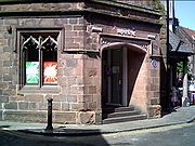
| St Nicholas' Chapel St Nicholas' Chapel, Chester is a former chapel in St Werburgh Street, Chester, Cheshire, England. Since it ceased functioning as a chapel it has had a number of uses, including being at one time a theatre. It is now used as a shop...
|
Building |
St Werburgh Street, Chester
53.19129°N 2.89095°W |
1280 |
CH35 |
Since ceasing use as a chapel it has been used for various purposes, including a wool hall and a theatre. It is now a shop and is a Grade II listed building. |
|
| St Oswald's well |
Well chamber |
Winwick Winwick is a village and civil parish in the borough of Warrington in Cheshire, England. Historically within Lancashire, until 1 April 1974, Winwick was administered as part of Lancashire with the rest of north Warrington. It is situated about three miles north of Warrington town centre, near...
53.4421°N 2.5925°W |
Medieval |
30378 |
The holy wellA holy well, or sacred spring, is a small body of water emerging from underground and revered either in a Pagan or Christian context, often both. Holy wells were frequently pagan sacred sites that later became Christianized. The term 'holy well' is commonly employed to refer to any water source of...
is lined with stones and contains steps; it is overgrown and covered by a stone slab |
|
| St Winefride's well |
Well head and drain channel |
Clutton Clutton is a village in the unitary authority of Cheshire West and Chester and the ceremonial county of Cheshire, England. It has a Church of England primary school.-External links:*...
53.0918°N 2.7874°W |
Medieval |
30380 |
The holy well consists of a stone wellhead and drainage channel |
|
| Swineyard Hall Swineyard Hall is a moated country house in the parish of High Legh, Cheshire, England. It was built in the 16th century, with additions made in the 19th century, and is still partly moated. The house is constructed partly in timber framing with rendered brick infill, and partly in...
moat |
Moat |
Near High Legh High Legh is a village and civil parish in the unitary authority of Cheshire East and the ceremonial county of Cheshire, England. It lies six miles north west of Knutsford, seven miles east of Warrington and seventeen miles south west of Manchester City Centre....
53.3503°N 2.4852°W |
Medieval |
13502 |
Three sides of the moat are preserved as a stone-lined ornamental pond. A 16th century hall stands on the platform. |
|
| Sutton End Farm cross |
Stone |
Sutton, Macclesfield
53.2203°N 2.0676°W |
Medieval |
25634 |
A sandstone block which was a waymarker. It is listed Grade II. |
|
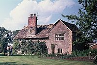
| Tabley Old Hall |
Derelict house |
Tabley Inferior
53.2926°N 2.4218°W |
c. 1380 and later |
13494 |
This consists of the remains of a house built in 1380, and subsequently extended, which used to contain a timber-framed hall. It partly collapsed in 1927 and was abandoned leaving a shell of the building which is listed Grade II*. |
|
| Tarporley churchyard cross |
Stone structure |
Tarporley Tarporley is a large village and civil parish in the unitary authority of Cheshire West and Chester and the ceremonial county of Cheshire, England....
53.1579°N 2.6691°W |
Medieval |
30371 |
This consists of a square base of red sandstone and a shaft of yellow sandstone which stands in St Helen'sSt Helen's Church, Tarporley is in the village of Tarporley, Cheshire, England. The church has been designated as a Grade II* listed building. It is an active Anglican parish church in the diocese of Chester, the archdeaconry of Chester and the deanery of Malpas...
churchyard. It is listed Grade II. |
|
| Tatton settlement, old hall and mill dam |
Earthworks |
Tatton Park Tatton Park is a historic estate in Cheshire, England, to the north of the town of Knutsford. It contains a mansion, Tatton Hall, a manor house dating from medieval times, Tatton Old Hall, gardens, a farm and a deer park of . It is a popular visitor attraction and hosts over 100 events annually...
53.3280°N 2.3673°W |
Late Neolithic, Saxon, and medieval |
30362 |
A former village occupied in the late Neolithic, Saxon and medieval periods. Now deserted and only earthworks remain. Includes the ground beneath Tatton Old Hall Tatton Old Hall is a historic building in Tatton Park near Knutsford, Cheshire, England. It has been designated by English Heritage as a Grade II* listed building which is owned by the National Trust and administered in conjunction with Cheshire East Council...
|
|
| Tilston churchyard cross |
Stone structure |
Tilston Tilston is a village and a civil parish in the unitary authority of Cheshire West and Chester and the ceremonial county of Cheshire, England. At the 2001 Census, the population was recorded as 627.St Mary's Church, Tilston is a Grade II* listed building....
53.0497°N 2.8110°W |
Medieval |
30372 |
This consists of a two steps with an octagonal base supporting an octagonal shaft. It stands in St Mary'sSt Mary's Church, Tilston stands in an isolated position to the south of the village of Tilston, Cheshire, England. The church has been designated by English Heritage as a Grade II* listed building. It is an active Anglican parish church in the diocese of Chester, the archdeaconry of Chester...
churchyard. |
|
| Toothill enclosure |
Earthworks |
Macclesfield Forest
53.2454°N 2.0440°W |
Medieval |
23611 |
A quadrilateral enclosure whose purpose is uncertain. |
|
| Upton Grange moat |
Moat |
Upton Upton by Chester is a civil parish and a large suburb on the outskirts of Chester, in the Borough of Cheshire West and Chester and the ceremonial county of Cheshire in England. It includes the villages of Upton and Upton Heath. At the 2001 Census the population was recorded as...
53.2163°N 2.8640°W |
Medieval |
13415 |
A dry moat to the east of Upton Grange |
|
Vale Royal AbbeyVale Royal Abbey is a medieval abbey, and later country house, located in Whitegate, between Northwich and Winsford in Cheshire, England.The abbey was founded in 1270 by Edward I for monks of the austere Cistercian order...
|
Buildings, foundations |
Vale Royal
53.2247°N 2.5423°W |
Medieval |
30398 |
The largest Cistercian church in England which was demolished after the ReformationThe Protestant Reformation was a 16th-century split within Western Christianity initiated by Martin Luther, John Calvin and other early Protestants. The efforts of the self-described "reformers", who objected to the doctrines, rituals and ecclesiastical structure of the Roman Catholic Church, led...
and replaced by a mansionA mansion is a very large dwelling house. U.S. real estate brokers define a mansion as a dwelling of over . A traditional European mansion was defined as a house which contained a ballroom and tens of bedrooms...
|
|
| Venables' tomb |
CanopiedA canopy is an overhead roof or else a structure over which a fabric or metal covering is attached, able to provide shade or shelter. A canopy can also be a tent, generally without a floor....
tombA tomb is a repository for the remains of the dead. It is generally any structurally enclosed interment space or burial chamber, of varying sizes...
|
Newbold Astbury thumb|AstburyNewbold Astbury is a village and civil parish in the unitary authority of Cheshire East and the ceremonial county of Cheshire, in the north-west of England. It is situated to the south of Congleton on the A34 road to Scholar Green; the A34 forms one side of the triangular village green...
53.1505°N 2.2315°W |
Late 13th century |
32563 |
A canopied tomb in the churchyard of St Mary'sSt Mary's Church, Astbury, is an Anglican parish church in the village of Newbold Astbury, Cheshire, England. It has been designated by English Heritage as a Grade I listed building, and its architecture has been praised by a number of writers....
. It is listed Grade II*, and is a scheduled monument. |
|
| Warmingham churchyard cross |
Stone structure |
Warmingham Warmingham is a village and civil parish in the unitary authority of Cheshire East and the ceremonial county of Cheshire, England. The village lies 3¼ miles to the north of Crewe and 3¼ miles to the west of Sandbach. The parish also includes the settlement of Lane Ends. Nearby villages include...
53.1459°N 2.4364°W |
c. 1298 |
30361 |
A cross base of three steps and a socket stone to which a later shaft has been added. It stands in St Leonard's St Leonard's Church, Warmingham, is in the village of Warmingham, Cheshire, England. The church has been designated by English Heritage as a Grade II* listed building. It is an active Anglican parish church in the diocese of Chester, the archdeaconry of Macclesfield and the deanery of...
churchyard and is a Grade II listed building. |
|
| Wervin chapel |
Ruined building |
Wervin Wervin is a small village and civil parish in the unitary authority of Cheshire West and Chester and the ceremonial county of Cheshire, England. It is situated between Chester and Ellesmere Port, in close proximity to the Shropshire Union Canal and the M53 motorway. At the 2001 Census, Wervin had a...
53.2403°N 2.8711°W |
13th century or earlier |
27590 |
Ruins of a chapel |
|
| Wood Farm moated site |
Earthworks |
Woolstanwood Woolstanwood is a village and civil parish in the unitary authority of Cheshire East and the ceremonial county of...
53.0995°N 2.4947°W |
Medieval |
30360 |
The moat was trapezoidal in shape and it enclosed a platform 90m square. |
|
Woodhey wayside crossWoodhey Cross is a late medieval stone cross, probably dating from the early 16th century, located near Faddiley in Cheshire, England. The structure is grade II* listed and is also a scheduled ancient monument...
|
Stone structure |
Faddiley Faddiley is a small village and civil parish in the unitary authority of Cheshire East and the ceremonial county of Cheshire, England. The village is located 4 miles to the west of Nantwich. The parish also includes the small settlements of Larden Green and Woodhey or Woodhey Green, with a total...
53.0694°N 2.6323°W |
Medieval |
32566 |
The remains of medieval wayside cross at the junction of four lanes which consist of a square section of a shaft standing on a socket stone on a number of pieces of stone from a later date. It is listed Grade II*. |
|
| Wybunbury moated site |
Moat |
Wybunbury
53.0426°N 2.4457°W |
Medieval |
13439 |
A moat surrounding a platform 40m square with outlet channels, a causeway and a nearby fishpond. |
|