

Baddiley
Encyclopedia
Cheshire East
Cheshire East is a unitary authority area with borough status in the ceremonial county of Cheshire, England.The borough was established in April 2009 as part of the 2009 structural changes to local government in England, by virtue of an order under the Local Government and Public Involvement in...
and the ceremonial county of Cheshire
Cheshire
Cheshire is a ceremonial county in North West England. Cheshire's county town is the city of Chester, although its largest town is Warrington. Other major towns include Widnes, Congleton, Crewe, Ellesmere Port, Runcorn, Macclesfield, Winsford, Northwich, and Wilmslow...
, England
England
England is a country that is part of the United Kingdom. It shares land borders with Scotland to the north and Wales to the west; the Irish Sea is to the north west, the Celtic Sea to the south west, with the North Sea to the east and the English Channel to the south separating it from continental...
. The civil parish also includes the north-western part of the village of Ravensmoor
Ravensmoor
Ravensmoor is a village in the unitary authority of Cheshire East and the ceremonial county of Cheshire, England, located at . It is split between the civil parishes of Baddiley and Burland...
(also in the parish of Burland
Burland
Burland is a village and civil parish in the unitary authority of Cheshire East and the ceremonial county of Cheshire, England, about 2½ miles west of Nantwich. The civil parish also includes the small settlements of Burland Lower Green, Burland Upper Green, Hollin Green and Stoneley Green, as well...
), as well as the small settlements of Baddiley Hulse, Batterley Hill, and parts of Gradeley Green and Swanley. According to the 2001 Census
United Kingdom Census 2001
A nationwide census, known as Census 2001, was conducted in the United Kingdom on Sunday, 29 April 2001. This was the 20th UK Census and recorded a resident population of 58,789,194....
the parish had a total population of 226.
The largest settlement within the parish, Ravensmoor centres around a crossroads with a small village green. It lies around six miles south west of Crewe
Crewe
Crewe is a railway town within the unitary authority area of Cheshire East and the ceremonial county of Cheshire, England. According to the 2001 census the urban area had a population of 67,683...
.
History
Baddiley is listed in the Domesday BookDomesday Book
Domesday Book , now held at The National Archives, Kew, Richmond upon Thames in South West London, is the record of the great survey of much of England and parts of Wales completed in 1086...
as Bedelie, and the manor then belonged to the Praers family. The ancient manor was more extensive than the modern parish, also including Faddiley
Faddiley
Faddiley is a small village and civil parish in the unitary authority of Cheshire East and the ceremonial county of Cheshire, England. The village is located 4 miles to the west of Nantwich. The parish also includes the small settlements of Larden Green and Woodhey or Woodhey Green, with a total...
, which lies to the north west. In the first half of the 13th century, part of the Baddiley parish was granted to Combermere Abbey
Combermere Abbey
Combermere Abbey is a former monastery in Combermere Park, between Nantwich and Whitchurch in Cheshire, England, near the border with Shropshire.-Topomony:...
, a Cistercian monastery which had been endowed on its foundation in 1133 with a large area of land to the south; in 1355, the abbey also acquired the right to appoint the priest of the Baddiley church in exchange for land at Baddiley Grange. (Baddiley is not, however, included among the lands surrendered to the government when the abbey was dissolved in 1538.) By the 14th century, the manor had passed by marriage to the Bromley, Hondford and Mainwaring families, finally passing solely to the Mainwarings who occupied Baddiley Hall
Baddiley Hall
Baddiley Hall is a country house in the settlement of Baddiley in Cheshire, England. Previously there was a half-timbered house on the site, but this had been replaced by the current house before the death of its owner, Sir Henry Mainwaring, in 1797. It is constructed in brown brick with a slate...
.
The parish formerly had a population of 276 (1801), 281 (1851), 211 (1901) and 219 (1951). Much of the village of Ravensmoor dates from the second half of the 20th century.
Geography and transport
Nantwich
Nantwich is a market town and civil parish in the Borough of Cheshire East and the ceremonial county of Cheshire, England. The town gives its name to the parliamentary constituency of Crewe and Nantwich...
. Nearby settlements include the village of Wrenbury
Wrenbury
Wrenbury is a village in the civil parish of Wrenbury cum Frith, the unitary authority of Cheshire East, and the ceremonial county of Cheshire, England...
and the hamlets of Acton
Acton, Cheshire
Acton is a small village and civil parish lying immediately west of the town of Nantwich in the unitary authority of Cheshire East and the ceremonial county of...
, Burland
Burland
Burland is a village and civil parish in the unitary authority of Cheshire East and the ceremonial county of Cheshire, England, about 2½ miles west of Nantwich. The civil parish also includes the small settlements of Burland Lower Green, Burland Upper Green, Hollin Green and Stoneley Green, as well...
, Faddiley
Faddiley
Faddiley is a small village and civil parish in the unitary authority of Cheshire East and the ceremonial county of Cheshire, England. The village is located 4 miles to the west of Nantwich. The parish also includes the small settlements of Larden Green and Woodhey or Woodhey Green, with a total...
and Sound Heath
Sound, Cheshire
Sound is a hamlet and civil parish in the unitary authority of Cheshire East and the ceremonial county of Cheshire, England. The hamlet is located 3¼ miles to the south west of Nantwich. The parish also includes the small settlements of Newtown and Sound Heath...
. Most of the civil parish is flat; the western edge, approaching the Weaver
River Weaver
The River Weaver is a river, navigable in its lower reaches, running in a curving route anti-clockwise across west Cheshire, northern England. Improvements to the river to make it navigable were authorised in 1720 and the work, which included eleven locks, was completed in 1732...
valley, is slightly more undulating in character, however, with a maximum elevation of 85 m. The land use is predominantly pasture, with some arable to the west.
The Llangollen branch
Llangollen Canal
The Llangollen Canal is a navigable canal crossing the border between England and Wales. The waterway links Llangollen in Denbighshire, north Wales, with Hurleston in south Cheshire, via the town of Ellesmere, Shropshire....
of the Shropshire Union Canal
Shropshire Union Canal
The Shropshire Union Canal is a navigable canal in England; the Llangollen and Montgomery canals are the modern names of branches of the Shropshire Union system and lie partially in Wales....
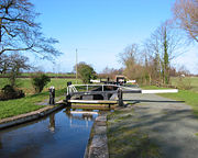
passes through the parish. This stretch of canal immediately south of Hurleston
Hurleston
Hurleston is a civil parish in the unitary authority of Cheshire East and the ceremonial county of Cheshire, England, which lies to the north west of Nantwich. The parish is predominantly rural with scattered farms and buildings and no settlements...
Junction (where the Llangollen branch splits from the main Shropshire Union) has three grade-II-listed lock
Lock (water transport)
A lock is a device for raising and lowering boats between stretches of water of different levels on river and canal waterways. The distinguishing feature of a lock is a fixed chamber in which the water level can be varied; whereas in a caisson lock, a boat lift, or on a canal inclined plane, it is...
s by J Fletcher and Thomas Telford
Thomas Telford
Thomas Telford FRS, FRSE was a Scottish civil engineer, architect and stonemason, and a noted road, bridge and canal builder.-Early career:...
. Constructed in blue-and-red brick with stone dressing, they date from 1805. The modern brick-and-concrete Baddiley Bridge carries the Nantwich road across the canal east of Baddiley Hulse (at SJ 607 494). There are also three older footbridges in traditional brick serving public rights of way: Halls Lane, Greenfield and an unnamed bridge.

Spinners Wood, a small area of mixed woodland (predominantly oak, birch, hazel and holly), planted by local volunteers in March 2000 to commemorate the millennium, stands just outside Ravensmoor (at SJ 620 505). Baddiley Gorse is a small deciduous wood by the Shropshire Union Canal (at SJ 610 509).
Places of worship
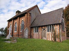
St Michael's Church, Baddiley
St Michael's Church, Baddiley is in the civil parish of Baddiley, Cheshire, England. It has been designated by English Heritage as a Grade I listed building. The church lies at the end of a lane near to Baddiley Hall, formerly the home of the Mainwaring family. It dates from the early...
(at SJ 604 502), is a rare example of a timber-framed church. Its chancel dates from 1308, and it is one of the oldest timber-framed churches in Europe. Only a handful of churches of this type remain in England; other surviving examples include churches at Lower Peover
St Oswald's Church, Lower Peover
St Oswald's Church, Lower Peover, is in the village of Lower Peover, Cheshire, England. It has been designated by English Heritage as a Grade I listed building. It is an active Anglican parish church in the diocese of Chester, the archdeaconry of Macclesfield and the deanery of Knutsford...
and Marton
St James' and St Paul's Church, Marton
The Church of St James and St Paul, Marton is situated to the south of the village of Marton, Cheshire, England. It has been designated by English Heritage as a Grade I listed building. It is an active Anglican parish church in the diocese of Chester, the archdeaconry of Macclesfield and the...
(Cheshire), Melverley
Melverley
Melverley is a village in Shropshire, England, situated on the River Severn and the River Vyrnwy, near the Powys hills and the border with Wales...
(Shropshire
Shropshire
Shropshire is a county in the West Midlands region of England. For Eurostat purposes, the county is a NUTS 3 region and is one of four counties or unitary districts that comprise the "Shropshire and Staffordshire" NUTS 2 region. It borders Wales to the west...
), Besford
Besford
Besford is a village and civil parish in the Wychavon district of Worcestershire, England. According to the 2001 census it had a population of 147. The village is near Pershore, off the road from Upton-upon-Severn. A historic house, Besford Court , is located in the village...
(Worcestershire
Worcestershire
Worcestershire is a non-metropolitan county, established in antiquity, located in the West Midlands region of England. For Eurostat purposes it is a NUTS 3 region and is one of three counties that comprise the "Herefordshire, Worcestershire and Warwickshire" NUTS 2 region...
) and Hartley Wespall
Hartley Wespall
Hartley Wespall is a civil parish in the Basingstoke & Deane district of Hampshire, England. Its nearest town is Hook, which lies approximately 2.5 miles south-west from the hamlet....
(Hampshire
Hampshire
Hampshire is a county on the southern coast of England in the United Kingdom. The county town of Hampshire is Winchester, a historic cathedral city that was once the capital of England. Hampshire is notable for housing the original birthplaces of the Royal Navy, British Army, and Royal Air Force...
). The original timber-framing was largely replaced by brick in 1811. The tympanum is one of the most interesting in England; it is dated 1663 but is structurally medieval and stands on an eight-foot screen.
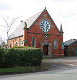
The parish also contains the Baddiley and Ravensmoor Methodist Church, formerly a Wesleyan Chapel, located in Ravensmoor. Dated 1878, the building is in orange brick with stone dressing and has a prominent circular window and pillars capped with decorative stonework.
Historically, St Mary's
St Mary's Church, Acton
St Mary's Church, Acton is an active Anglican church in Acton, a village to the west of Nantwich, Cheshire, England. It has been designated by English Heritage as a Grade I listed building. A church has been present on this site since before the time of the Domesday Survey. The tower is the...
at nearby Acton
Acton, Cheshire
Acton is a small village and civil parish lying immediately west of the town of Nantwich in the unitary authority of Cheshire East and the ceremonial county of...
also served part of the civil parish of Baddiley.
Other notable buildings
Other notable buildings within the parish include the grade-II-listed Baddiley Hall, an L-shaped three-storey building in brown brick dating from the late 17th century. Formerly the manor house of the Mainwaring family, it has been a farmhouse since the 19th century. Several other farmhouses within the parish are also listed, including Springe Lane Hall (early 17th century), Crabmill Farmhouse (early 19th century), and Baddiley Farmhouse and farmbuildings (c. 1870).The Farmer's Arms public house stands at the crossroads opposite the village green in the centre of Ravensmoor.