
Grade I listed buildings in Cheshire
Encyclopedia
The Grade I listed buildings in Cheshire, excluding those in the city of Chester
, total around 80, almost half of which are churches.
Most Cheshire buildings are in sandstone
, brick or are timber framed
. The churches are mainly built in stone, while the domestic buildings are mainly in brick. Limestone
is used for some buildings in the east of the county. Compared with other counties, timber framing is important. Cheshire has a higher proportion of timber framed houses than most other English counties. Pevsner
describes timber framed churches as "the main Cheshire specialty" and states that they are the earliest of their kind in Europe.
Chester
Chester is a city in Cheshire, England. Lying on the River Dee, close to the border with Wales, it is home to 77,040 inhabitants, and is the largest and most populous settlement of the wider unitary authority area of Cheshire West and Chester, which had a population of 328,100 according to the...
, total around 80, almost half of which are churches.
Most Cheshire buildings are in sandstone
Sandstone
Sandstone is a sedimentary rock composed mainly of sand-sized minerals or rock grains.Most sandstone is composed of quartz and/or feldspar because these are the most common minerals in the Earth's crust. Like sand, sandstone may be any colour, but the most common colours are tan, brown, yellow,...
, brick or are timber framed
Timber framing
Timber framing , or half-timbering, also called in North America "post-and-beam" construction, is the method of creating structures using heavy squared off and carefully fitted and joined timbers with joints secured by large wooden pegs . It is commonplace in large barns...
. The churches are mainly built in stone, while the domestic buildings are mainly in brick. Limestone
Limestone
Limestone is a sedimentary rock composed largely of the minerals calcite and aragonite, which are different crystal forms of calcium carbonate . Many limestones are composed from skeletal fragments of marine organisms such as coral or foraminifera....
is used for some buildings in the east of the county. Compared with other counties, timber framing is important. Cheshire has a higher proportion of timber framed houses than most other English counties. Pevsner
Nikolaus Pevsner
Sir Nikolaus Bernhard Leon Pevsner, CBE, FBA was a German-born British scholar of history of art and, especially, of history of architecture...
describes timber framed churches as "the main Cheshire specialty" and states that they are the earliest of their kind in Europe.
Churches
| Name | Place | Coordinates | Date | Notes | Refs | Image |
|---|---|---|---|---|---|---|
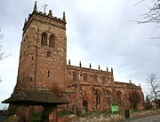
| St Mary St Mary's Church, Acton St Mary's Church, Acton is an active Anglican church in Acton, a village to the west of Nantwich, Cheshire, England. It has been designated by English Heritage as a Grade I listed building. A church has been present on this site since before the time of the Domesday Survey. The tower is the... |
Acton Acton, Cheshire Acton is a small village and civil parish lying immediately west of the town of Nantwich in the unitary authority of Cheshire East and the ceremonial county of... |
53.0737 °N 2.5512 °W | Tower c, 1180, body 14th century and later |
The tower, which is the oldest in Cheshire, collapsed in 1757 and was rebuilt to a lower level. One of Clifton-Taylor's "best" English parish churches. |
 |
|
| St Peter St Peter's Church, Aston-by-Sutton St Peter's Church, Aston-by-Sutton is in the small hamlet of Aston-by-Sutton, Cheshire near to the town of Runcorn. The church has been designated by English Heritage as a Grade I listed building. It is an active Anglican parish church in the diocese of Chester, the archdeaconry of Chester... |
Aston Aston, Vale Royal right|thumb|200px|Map of civil parish of Aston within the former borough of Vale RoyalAston is a village and civil parish in the unitary authority of Cheshire West and Chester and the ceremonial county of Cheshire, England. According to the 2001 census it had a population of 111... |
53.3012 °N 2.6679 °W | 1697; 1736–40 | Described as "a most pleasing late 17th to early 18th century church, inside and out". | 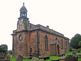 |
|
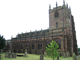
| St James St James' Church, Audlem St James' Church, Audlem is located in the village of Audlem in south Cheshire, England. It has been designated by English Heritage as a Grade I listed building, The church dates from the late 13th century with additions in the 19th century. It is an active Anglican parish church... |
Audlem Audlem Audlem is a large village and civil parish located in the unitary authority of Cheshire East and the ceremonial county of Cheshire in the north west of England, approximately south of Nantwich. Close to the border with the neighbouring county of Shropshire, the village is eight miles east of... |
52.9891 °N 2.5079 °W | Late 13th century and later | The church stands in an elevated position in the centre of the village. | 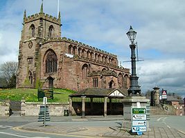 |
|
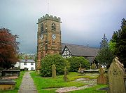
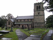
| St Michael St Michael's Church, Baddiley St Michael's Church, Baddiley is in the civil parish of Baddiley, Cheshire, England. It has been designated by English Heritage as a Grade I listed building. The church lies at the end of a lane near to Baddiley Hall, formerly the home of the Mainwaring family. It dates from the early... |
Baddiley Baddiley Baddiley is a scattered settlement and civil parish in the unitary authority of Cheshire East and the ceremonial county of Cheshire, England. The civil parish also includes the north-western part of the village of Ravensmoor , as well as the small settlements of Baddiley Hulse, Batterley Hill, and... |
53.0489 °N 2.5905 °W | 1308 | Timber framed Timber framing Timber framing , or half-timbering, also called in North America "post-and-beam" construction, is the method of creating structures using heavy squared off and carefully fitted and joined timbers with joints secured by large wooden pegs . It is commonplace in large barns... church, mainly encased in brick in 1811. |
 |
|
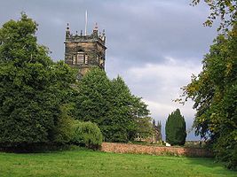
| St Bertoline St Bertoline's Church, Barthomley St Bertoline's Church, Barthomley is in the village of Barthomley, Cheshire, England. The church has been designated by English Heritage as a Grade I listed building... |
Barthomley Barthomley Barthomley is a village and ancient parish, and is now a civil parish in the unitary authority of Cheshire East and the ceremonial county of Cheshire, England. According to the 2001 census the parish had a population of 202. The village is situated near junction 16 of the M6 motorway and by the... |
53.0682 °N 2.3483 °W | Late 15th century | Chancel dates from 1925–26. Richards considers it to be one of the most beautiful churches in the county and believes it is the only one in England to be dedicated to St Bertoline. | 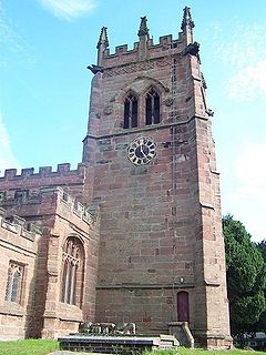 |
|
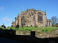
| St Boniface St Boniface's Church, Bunbury St Boniface's Church, Bunbury, stands prominently in the village of Bunbury, Cheshire, England. It has been designated by English Heritage as a Grade I listed building. The church dates mainly from the 14th century. Its features include the Ridley chapel, the alabaster chest tomb of... |
Bunbury Bunbury, Cheshire Bunbury is a village and civil parish in the unitary authority of Cheshire East and the ceremonial county of Cheshire, England, south of Tarporley, north west of Nantwich, and on the Shropshire Union Canal... |
53.1182 °N 2.6453 °W | 1320 and later | In 1385–86 endowed as a collegiate church Collegiate church In Christianity, a collegiate church is a church where the daily office of worship is maintained by a college of canons; a non-monastic, or "secular" community of clergy, organised as a self-governing corporate body, which may be presided over by a dean or provost... ; chantry Chantry Chantry is the English term for a fund established to pay for a priest to celebrate sung Masses for a specified purpose, generally for the soul of the deceased donor. Chantries were endowed with lands given by donors, the income from which maintained the chantry priest... chapel added in 1527. One of Clifton-Taylor's "best" English parish churches. |
 |
|
| St Nicholas' Chapel St Nicholas' Chapel, Cholmondeley St Nicholas' Chapel, Cholmondeley is a private chapel in the grounds of Cholmondeley Castle, Cheshire, England, the ancient seat of the Marquess of Cholmondeley, hereditary Lord Great Chamberlain of England. It has been designated by English Heritage as a Grade I listed building.-History:This... |
Cholmondeley Cholmondeley, Cheshire Cholmondeley is a civil parish in the unitary authority of Cheshire East and the ceremonial county of Cheshire, England, which lies to the north east of Malpas and to the west of Nantwich. It includes the small settlements of Croxton Green and Dowse Green , with a total population of a little... |
53.0573 °N 2.6932 °W | 13th century and later | Private chapel to Cholmondeley Castle Cholmondeley Castle Cholmondeley Castle is a country house in the civil parish of Cholmondeley, Cheshire, England. It has been designated by English Heritage as a Grade II* listed building. It is surrounded by a estate.-House:... . Originally timber framed, encased in brick in 1716; transept Transept For the periodical go to The Transept.A transept is a transverse section, of any building, which lies across the main body of the building. In Christian churches, a transept is an area set crosswise to the nave in a cruciform building in Romanesque and Gothic Christian church architecture... s added 1829. |
 |
|
| Eaton Chapel Eaton Chapel Eaton Chapel is a private chapel to the north of Eaton Hall in Eaton Park, near the village of Eccleston, Cheshire, England. It is designated by English Heritage as a Grade I listed building.-History:... |
Eaton Hall Eaton Hall (Cheshire) Eaton Hall is the country house of the Duke of Westminster. It is set within a large estate south of the village of Eccleston, in Cheshire, England . The house is surrounded by formal gardens, parkland, farmland and woodland. The estate covers an area of about .The first substantial house was... |
53.1409 °N 2.8776 °W | 1873–84 | Private chapel to Eaton Hall by Alfred Waterhouse Alfred Waterhouse Alfred Waterhouse was a British architect, particularly associated with the Victorian Gothic Revival architecture. He is perhaps best known for his design for the Natural History Museum in London, and Manchester Town Hall, although he also built a wide variety of other buildings throughout the... for the 1st Duke of Westminster Hugh Grosvenor, 1st Duke of Westminster Hugh Lupus Grosvenor, 1st Duke of Westminster KG, PC, JP , styled Viscount Belgrave between 1831 and 1845 and Earl Grosvenor between 1845 and 1869 and known as the 3rd Marquess of Westminster between 1869 and 1874, was an English landowner, politician and racehorse owner.He inherited the estate of... . |
||
| St Mary St Mary's Church, Eccleston St Mary's Church, Eccleston, is in the village of Eccleston, Cheshire, England, on the estate of the Duke of Westminster south of Chester. The church is designated by English Heritage as a Grade I listed building. It is an active Anglican parish church in the diocese of Chester, the... |
Eccleston Eccleston, Cheshire Eccleston is a civil parish and village in the unitary authority of Cheshire West and Chester and the ceremonial county of Cheshire, and close to Chester... |
53.1576 °N 2.8794 °W | 1899 | By G. F. Bodley George Frederick Bodley George Frederick Bodley was an English architect working in the Gothic revival style.-Personal life:Bodley was the youngest son of William Hulme Bodley, M.D. of Edinburgh, physician at Hull Royal Infirmary, Kingston upon Hull, who in 1838 retired to his wife's home town, Brighton, Sussex, England.... for the 1st Duke of Westminster. |
 |
|
| Woodhey Chapel Woodhey Chapel, Faddiley Woodhey Chapel is a Grade I listed private chapel off Woodhey Lane near Faddiley, Cheshire, England. The listing describes the building as 'A handsome and intact example of a chapel from a period when few were built'. The chapel, which is now disused, stands in fields near the site of the... |
Faddiley Faddiley Faddiley is a small village and civil parish in the unitary authority of Cheshire East and the ceremonial county of Cheshire, England. The village is located 4 miles to the west of Nantwich. The parish also includes the small settlements of Larden Green and Woodhey or Woodhey Green, with a total... |
53.0706 °N 2.6383 °W | c. 1700 | Built by Lady Wilbraham, the widow of the Thomas Wilbraham, the last baronet of Woodhey. Described as 'A handsome and intact example of a chapel from a period when few were built.' The chapel is now disused. | 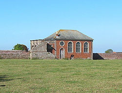 |
|
| St Laurence St Laurence's Church, Frodsham St Laurence's Church, Frodsham is in Church Road, Frodsham, Cheshire, England. The church stands, not in the centre of the town, but in the elevated area of Overton overlooking the town. It has been designated by English Heritage as a Grade I listed building... |
Frodsham Frodsham Frodsham is a market town and civil parish in the unitary authority of Cheshire West and Chester and the ceremonial county of Cheshire, England. Its population is 8,982. It is approximately south of Runcorn, 16 miles south of Liverpool, and approximately south-west of Manchester... |
53.2905 °N 2.7196 °W | c. 1180 and later | The nave is considered to be one of the finest examples of Norman architecture Norman architecture About|Romanesque architecture, primarily English|other buildings in Normandy|Architecture of Normandy.File:Durham Cathedral. Nave by James Valentine c.1890.jpg|thumb|200px|The nave of Durham Cathedral demonstrates the characteristic round arched style, though use of shallow pointed arches above the... in Cheshire. |
 |
|
| St James St James' Church, Gawsworth St James' Church, Gawsworth, is in the village of Gawsworth, Cheshire, England, and is sited near Gawsworth Hall. It has been designated by English Heritage as a Grade I listed building. It is an active Anglican parish church in the diocese of Chester, the archdeaconry of Macclesfield and... |
Gawsworth Gawsworth Gawsworth is a civil parish and village in the unitary authority of Cheshire East and the ceremonial county of Cheshire, England. It is one of the eight ancient parishes of Macclesfield Hundred. Twenty acres of the civil parish were transferred to Macclesfield civil parish in 1936The country houses... |
53.2241 °N 2.1661 °W | 1430; 15th century |
Contains tombs of the Fitton family. One of Clifton-Taylor's "best" English parish churches. |
 |
|
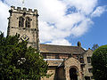
| St Wilfrid St Wilfrid's Church, Grappenhall St Wilfrid's Church, Grappenhall, is in Church Lane, Grappenhall, a village near Warrington, Cheshire, England. It has been designated by English Heritage as a Grade I listed building... |
Grappenhall Grappenhall Grappenhall is a suburban village in Warrington, Cheshire, England. It is situated along the Bridgewater Canal, and forms one of the principal settlements of Grappenhall and Thelwall civil parish... |
53.3723 °N 2.5434 °W | 12th century with later additions | 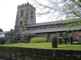 |
||
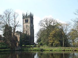
| St Mary and All Saints St Mary and All Saints Church, Great Budworth St Mary and All Saints Church, Great Budworth, is in the centre of the village of Great Budworth, Cheshire, England. It has been designated by English Heritage as a Grade I listed building. It is an active Anglican parish church in the diocese of Chester, the archdeaconry of Chester and the... |
Great Budworth Great Budworth Great Budworth is a civil parish and village, approximately north of Northwich, England, within the unitary authority of Cheshire West and Chester and the ceremonial county of Cheshire. It lies off the A559 road, east of Comberbach, northwest of Higher Marston and southeast of Budworth Heath... |
53.2936 °N 2.5043 °W | 14th century and later | Pevsner Nikolaus Pevsner Sir Nikolaus Bernhard Leon Pevsner, CBE, FBA was a German-born British scholar of history of art and, especially, of history of architecture... considers it to be "one of the most satisfactory perpendicular churches in Cheshire". One of Clifton-Taylor's "best" English parish churches. |
 |
|
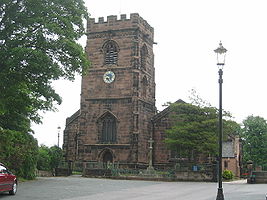
| St Luke St Luke's Church, Holmes Chapel St Luke's Church, Holmes Chapel is in the village of Holmes Chapel, Cheshire, England on the A50 road at its junction with the A535 road. The church has been designated by English Heritage as a Grade I listed building... |
Holmes Chapel Holmes Chapel Holmes Chapel is a village and civil parish in the unitary authority of Cheshire East and the ceremonial county of Cheshire, England. Until 1974 the parish was known as Church Hulme.At the 2001 Census the population of the village was recorded as 5,669... |
53.2020 °N 2.3575 °W | c. 1430 | Originally a timber framed church. Encased in brick in the early 18th century. Further restorations since. |  |
|
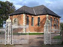
| Brook Street Chapel Brook Street Chapel, Knutsford Brook Street Chapel, Knutsford, is in the town of Knutsford, Cheshire, England. It has been designated by English Heritage as a Grade I listed building. The chapel was built in soon after the passing of the Act of Toleration 1689. It is built in red brick with a stone-flagged roof in two... |
Knutsford Knutsford Knutsford is a town and civil parish in the unitary authority area of Cheshire East and the ceremonial county of Cheshire, in North West England... |
53.3017°N 2.3701°W | 1689 | In red brick with two external staircases. | ||
| St Oswald St Oswald's Church, Lower Peover St Oswald's Church, Lower Peover, is in the village of Lower Peover, Cheshire, England. It has been designated by English Heritage as a Grade I listed building. It is an active Anglican parish church in the diocese of Chester, the archdeaconry of Macclesfield and the deanery of Knutsford... |
Lower Peover Lower Peover right|thumb|200px|Map of civil parish of Nether Peover within the former borough of Vale RoyalLower Peover is a village in the civil parish of Nether Peover in the unitary authority of Cheshire West and Chester and the ceremonial county of Cheshire, England, approximately 6 miles east of Northwich... |
53.2639 °N 2.3864 °W | 14th century and later | Timber framed with a sandstone Sandstone Sandstone is a sedimentary rock composed mainly of sand-sized minerals or rock grains.Most sandstone is composed of quartz and/or feldspar because these are the most common minerals in the Earth's crust. Like sand, sandstone may be any colour, but the most common colours are tan, brown, yellow,... tower. |
 |
|
| St Oswald | Malpas Malpas, Cheshire Malpas is a large village which used to be a market town, and it is also a civil parish in the unitary authority of Cheshire West and Chester and the ceremonial county of Cheshire, England. The parish lies on the border with Shropshire and Wales... |
53.0195 °N 2.7670 °W | 14th century with later additions | Recognised as being one of the best examples in Cheshire of a late 15th to early 16th century church. One of Clifton-Taylor's "best" English parish churches. |
 |
|
| St James and St Paul St James' and St Paul's Church, Marton The Church of St James and St Paul, Marton is situated to the south of the village of Marton, Cheshire, England. It has been designated by English Heritage as a Grade I listed building. It is an active Anglican parish church in the diocese of Chester, the archdeaconry of Macclesfield and the... |
Marton Marton, Cheshire Marton, Cheshire is a small village and civil parish in the unitary authority of Cheshire East and the ceremonial county of Cheshire, England on the A34 road 3 miles north of Congleton .... |
53.2088 °N 2.2257 °W | c. 1370 with later additions and alterations | Timber framed church founded by the de Davenport family. | 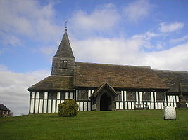 |
|
| St Peter St Peter's Church, Plemstall St Peter's Church, Plemstall stands in an isolated position at the end of a country lane near the village of Mickle Trafford, Cheshire, England. It has been designated by English Heritage as a Grade I listed building. It is an active Anglican parish church in the diocese of Chester, the... |
Mickle Trafford Mickle Trafford Mickle Trafford is a village and civil parish in the unitary authority of Cheshire West and Chester and the ceremonial county of Cheshire, England. It includes the area known as Plemstall. In 2004 the population of the civil parish was estimated to be 2,140, although the 2001 census recorded... |
53.2251 °N 2.8147 °W | 15th century and later | Financed by the Trafford family. Contains much interior woodwork by Rev. Toogood, a previous rector. | 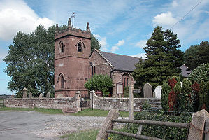 |
|
| St Wilfrid St Wilfrid's Church, Mobberley St Wilfrid's Church, Mobberley stands to the north of the village of Mobberley, Cheshire, England. The church has been designated by English Heritage as a Grade I listed building. It is an active Anglican parish church in the diocese of Chester, the archdeaconry of Macclesfield and the... |
Mobberley Mobberley Mobberley is a semi-rural village and civil parish in the unitary authority of Cheshire East and the ceremonial county of Cheshire, situated between Wilmslow and Knutsford. Mobberley railway station lies on the Manchester to Northwich and Chester line and was opened on 12 May, 1862 by the Cheshire... |
53.3182 °N 2.3161 °W | c. 1245 with later additions and alterations | Built on the site of a former Saxon church. One of Clifton-Taylor's "best" English parish churches. |
 |
|
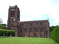
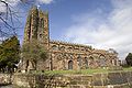
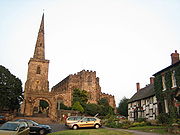
| St Mary St Mary's Church, Nantwich St Mary's Church, Nantwich, is in the centre of the market town of Nantwich, Cheshire, England. The church has been designated by English Heritage as a Grade I listed building. It has been called the "Cathedral of South Cheshire" and it is considered by some to be one of the finest medieval... |
Nantwich Nantwich Nantwich is a market town and civil parish in the Borough of Cheshire East and the ceremonial county of Cheshire, England. The town gives its name to the parliamentary constituency of Crewe and Nantwich... |
53.0671 °N 2.5206 °W | c. 1380 | Large cruciform parish church in sandstone with an octagonal tower, mainly in decorated style with later perpendicular additions. | .jpg) |
|
| St Mary St Mary's Church, Nether Alderley St Mary's Church, Nether Alderley, is an Anglican church at the end of a lane to the south of the village of Nether Alderley, Cheshire, England. It dates from the 14th century, with later additions and a major restoration in the late-19th century... |
Nether Alderley Nether Alderley Nether Alderley is a village and civil parish in the unitary authority of Cheshire East and the ceremonial county of Cheshire, England. It lies on the A34 road about a mile and a half south of Alderley Edge.... |
53.2820 °N 2.2389 °W | 14th century with later additions | The elaborate Stanley pew is entered from the outside of the church. One of Clifton-Taylor's "best" English parish churches. |
 |
|
| St Mary St Mary's Church, Astbury St Mary's Church, Astbury, is an Anglican parish church in the village of Newbold Astbury, Cheshire, England. It has been designated by English Heritage as a Grade I listed building, and its architecture has been praised by a number of writers.... |
Newbold Astbury Newbold Astbury thumb|AstburyNewbold Astbury is a village and civil parish in the unitary authority of Cheshire East and the ceremonial county of Cheshire, in the north-west of England. It is situated to the south of Congleton on the A34 road to Scholar Green; the A34 forms one side of the triangular village green... |
53.1507 °N 2.2314 °W | 15th century | Restored Victorian restoration Victorian restoration is the term commonly used to refer to the widespread and extensive refurbishment and rebuilding of Church of England churches and cathedrals that took place in England and Wales during the 19th-century reign of Queen Victoria... in 1862 by Sir George Gilbert Scott George Gilbert Scott Sir George Gilbert Scott was an English architect of the Victorian Age, chiefly associated with the design, building and renovation of churches, cathedrals and workhouses... . It contains more medieval fittings and furniture than any other Cheshire church. One of Clifton-Taylor's "best" English parish churches. Pevsner calls it "one of the most exciting Cheshire churches". |
 |
|
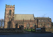
| St Helen St Helen Witton Church, Northwich St Helen Witton Church, Northwich, is in the centre of the town of Northwich, Cheshire, England. It has been designated by English Heritage as a Grade I listed building. The church is now known as "St Helen's, Witton" or "Northwich Parish Church". It is an active Anglican parish church... |
Northwich Northwich Northwich is a town and civil parish in the unitary authority of Cheshire West and Chester and the ceremonial county of Cheshire, England. It lies in the heart of the Cheshire Plain, at the confluence of the rivers Weaver and Dane... |
53.2602 °N 2.5046 °W | 14th century and later | One of Clifton-Taylor's "best" English parish churches. | 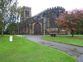 |
|
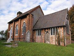
| St Lawrence St Lawrence's Church, Over Peover St Lawrence's Church, Over Peover is in an isolated position approached by a lane in the civil parish of Peover Superior. The only other buildings nearby are Peover Hall and a farm. It lies some south of the town of Knutsford, Cheshire, England). The church has been designated by English... |
Peover Superior Peover Superior Peover Superior is a civil parish in the unitary authority of Cheshire East and the ceremonial county of Cheshire, England.It contains the village of Over Peover and Peover Hall. St Lawrence's Church, Over Peover is a Grade I listed building.... |
53.2582 °N 2.3431 °W | 1456 and later | Contains monuments to the Mainwaring family. | ||
| St Christopher St Christopher's Church, Pott Shrigley St Christopher's Church, Pott Shrigley is in the small village of Pott Shrigley, Cheshire, England. The church has been designated by English Heritage as a Grade I listed building... |
Pott Shrigley Pott Shrigley Pott Shrigley is a small village and civil parish in the unitary authority of Cheshire East and the ceremonial county of Cheshire, England. According to the 2001 census, the civil parish and village has a population of 220. The nearest town is Bollington to the southwest.The village has a Church... |
53.3098 °N 2.0847 °W | Late 14th century | Almost entirely Perpendicular in style. | 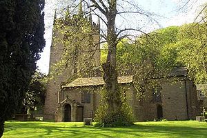 |
|
| St Peter St Peter's Church, Prestbury St Peter's Church is the parish church of Prestbury, Cheshire, England. It is probably the fourth church on the site. The third, the Norman Chapel, stands in the churchyard. The church has been designated by English Heritage as a Grade I listed building. The Norman Chapel, the lychgate and... |
Prestbury Prestbury, Cheshire Prestbury is a village, civil parish and ecclesiastical parish in the unitary authority of Cheshire East and the ceremonial county of Cheshire, England. Prestbury is a long, narrow parish covering 1,165 hectares to the west of the Peak Park foothills and to the east of the sandstone ridge which is... |
53.2893°N 2.15025 °W | 1220 and later | The Norman chapel in the churchyard is the predecessor of the present church. | 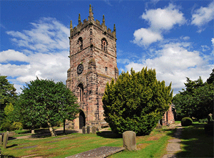 |
|
| St Mary St Mary's Church, Rostherne St Mary's Church, Rostherne lies between the village of Rostherne and Rostherne Mere in Cheshire, England. The church has been designated by English Heritage as a Grade I listed building. It is an active Anglican parish church in the diocese of Chester, the archdeaconry of Macclesfield and... |
Rostherne Rostherne Rostherne is a civil parish and village in the unitary authority of Cheshire East and the ceremonial county of Cheshire, England .To the north of the village is Rostherne Mere and to the south is Tatton Park... |
53.3495 °N 2.3880 °W | 1742–44 and later | Rebuilt after the tower fell in 1741. Chancel and north vestry of 1888 are by Sir Arthur Blomfield Arthur Blomfield Sir Arthur William Blomfield was an English architect.-Background:The fourth son of Charles James Blomfield, an Anglican Bishop of London helpfully began a programme of new church construction in the capital. Born in Fulham Palace, Arthur Blomfield was educated at Rugby and Trinity College,... . |
 |
|
| St Peter St Peter's Church, Tabley St Peter's Church, Tabley, is a chapel to the west of Tabley House near Knutsford, Cheshire, England. It has been designated by English Heritage as a Grade I listed building.-History:... |
Tabley House Tabley House Tabley House is a former stately home in Tabley Inferior , some to the east of the town of Knutsford, Cheshire, England. The house has been designated by English Heritage as a Grade I listed building. It was built between 1761 and 1769 for Sir Peter Byrne Leicester, to replace an older... |
53.2961 °N 2.4142 °W | 1675–78; c. 1720 | Private chapel to Tabley House. Moved to present position in 1927. | 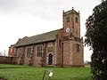 |
|
| St Edith St Edith's Church, Shocklach St Edith's Church, Shocklach, stands at the end of an isolated lane running toward the River Dee about to the north of the village of Shocklach, Cheshire, England. It is a small Norman church, and is one of the oldest ecclesiastical buildings in Cheshire... |
Shocklach Shocklach Shocklach is a village in the civil parishes of Church Shocklach and Shocklach Oviatt, Cheshire, England.St Edith's Church, Shocklach is a Grade I listed building.-External links:... |
53.0459 °N 2.8490 °W | c. 1150 with later additions | A small Norman church, one of the oldest ecclesiastical buildings in Cheshire. | 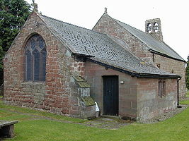 |
|
| St Michael St Michael's Church, Shotwick St Michael's Church, Shotwick is in the village of Shotwick, Cheshire, England. It has been designated by English Heritage as a Grade I listed building. It has a Norman doorway but most of the church dates from the medieval period. Its furniture includes some ancient items. In the... |
Shotwick Shotwick Shotwick is a village and civil parish on the Wirral Peninsula in the unitary authority of Cheshire West and Chester and the ceremonial county of Cheshire, England... |
53.2388 °N 2.9951 °W | 14th century | A Norman doorway remains but most of the church dates from the 14th century. | 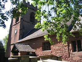 |
|
| St Andrew St Andrew's Church, Tarvin St Andrew's Church, Tarvin, is in the village of Tarvin, Cheshire, England. The church has been designated by English Heritage as a Grade I listed building. It is an active Anglican parish church in the diocese of Chester, the archdeaconry of Chester and the deanery of Chester... |
Tarvin Tarvin Tarvin is a village in the unitary authority of Cheshire West and Chester and the ceremonial county of Cheshire, England. It had a population of 2,693 people at the 2001 UK census, and the ward covers about .-Location:... |
53.1974 °N 2.7620 °W | 14th century and later | The tower and remainder of the church were built in the 15th century and there have been restorations since. | 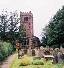 |
|
| St Mary St Mary's Church, Thornton-le-Moors St Mary's Church, Thornton-le-Moors is a redundant Anglican church in the small village of Thornton-le-Moors, Cheshire, England. The church has been designated by English Heritage as a Grade I listed building, and it is in the care of the Churches Conservation Trust.-History:A chapel was... |
Thornton-le-Moors Thornton-le-Moors Thornton-le-Moors is a village and civil parish in the unitary authority of Cheshire West and Chester and the ceremonial county of Cheshire, England. At the census of 2001 it had a population of 260.... |
53.2650 °N 2.8386 °W | 14th century and later | A chapel and the tower date from the 16th century and a south porch from the 17th century. | 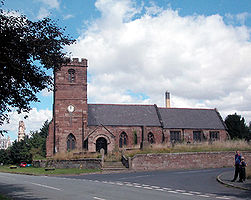 |
|
| St Chad St Chad's Chapel, Tushingham St Chad's Chapel, Tushingham is in the scattered community of Tushingham in the civil parish of Tushingham cum Grindley, Cheshire, England. The only approach to the chapel is on footpaths across fields from the A41 road... |
Tushingham Tushingham Tushingham is a scattered community in the civil parish of Tushingham cum Grindley, Cheshire, England.St Chad's Chapel, Tushingham is a Grade I listed building. There are also a number of Grade II listed buildings which include Tushingham Hall, Tushingham House and the Blue Bell Inn.-External links:... |
53.0117 °N 2.7057 °W | 1689–91 | A chapel standing in open countryside approached by a footpath across fields. |  |
|
| St Mary St Mary's Church, Weaverham St Mary's Church, Weaverham is in the village of Weaverham, Cheshire, England. The church has been designated by English Heritage as a Grade I listed building. It is an active Anglican parish church in the Diocese of Chester, the archdeaconry of Chester and the deanery of... |
Weaverham Weaverham right|thumb|200px|Map of civil parish of Weaverham within former borough of Vale RoyalWeaverham is a village and civil parish in the Borough of Cheshire West and Chester and the ceremonial county of Cheshire in England. Just off the A49, it is just to the west of Northwich and south of the River... |
53.2638 °N 2.5757 °W | 15th–16th century | Restoration Victorian restoration Victorian restoration is the term commonly used to refer to the widespread and extensive refurbishment and rebuilding of Church of England churches and cathedrals that took place in England and Wales during the 19th-century reign of Queen Victoria... s 1855 by Anthony Salvin Anthony Salvin Anthony Salvin was an English architect. He gained a reputation as an expert on medieval buildings and applied this expertise to his new buildings and his restorations... and 1877 by John Douglas John Douglas (architect) John Douglas was an English architect who designed about 500 buildings in Cheshire, North Wales, and northwest England, in particular in the estate of Eaton Hall. He was trained in Lancaster and practised throughout his career from an office in Chester, Cheshire... . |
 |
|
| St Bartholomew St Bartholomew's Church, Wilmslow St Bartholomew's Church, Wilmslow, is in the town of Wilmslow, Cheshire, England. The church has been designated by English Heritage as a Grade I listed building. It is an active Anglican parish church in the diocese of Chester, the archdeaconry of Macclesfield and the deanery of... |
Wilmslow Wilmslow -Economy:Wilmslow is well known, like Alderley Edge, for having many famous residents, notably footballers, stars of Coronation Street and rich North West businessmen. The town is part of the so-called Golden Triangle in the north west together with Alderley Edge and Prestbury... |
53.3301 °N 2.2296 °W | Early 16th century and later | 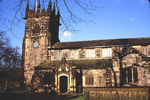 |
||
| St Oswald St Oswald's Church, Winwick St Oswald's Church, Winwick, is in the village of Winwick to the north of Warrington, Cheshire, England. The church has been designated by English Heritage as a Grade I listed building. It is an active Anglican parish church in the diocese of Liverpool, the archdeaconry of Warrington and the... |
Winwick Winwick, Cheshire Winwick is a village and civil parish in the borough of Warrington in Cheshire, England. Historically within Lancashire, until 1 April 1974, Winwick was administered as part of Lancashire with the rest of north Warrington. It is situated about three miles north of Warrington town centre, near... |
53.4308 °N 2.5979 °W | Early 13th century and later | Rebuilding by Pugin 1847–49. | 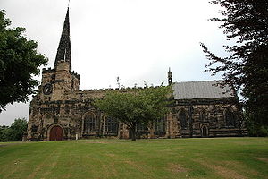 |
|
Other structures
| Name | Place | Map ref | Date | Notes | Refs | Image |
|---|---|---|---|---|---|---|
| Dorfold Hall Dorfold Hall Dorfold Hall is a Jacobean mansion in Acton, near Nantwich, in Cheshire, UK. It is listed at grade I. It was considered by Nikolaus Pevsner to be one of the two finest Jacobean houses in Cheshire.The present owners are the Roundells.-History:... |
Acton Acton, Cheshire Acton is a small village and civil parish lying immediately west of the town of Nantwich in the unitary authority of Cheshire East and the ceremonial county of... |
53.0685 °N 2.5451 °W | 1616–21 | Built for Ralph Wilbraham. Considered to be one of the two finest Jacobean Jacobean architecture The Jacobean style is the second phase of Renaissance architecture in England, following the Elizabethan style. It is named after King James I of England, with whose reign it is associated.-Characteristics:... houses in Cheshire. |
 |
|
| Adlington Hall Adlington Hall Adlington Hall is a country house in Cheshire, England. The oldest part of the existing building, the Great Hall, was constructed between 1480 and 1505; the east wing was added in 1581. The Legh family has lived in the hall and in previous buildings on the same site since the early 14th century... |
Adlington Adlington, Cheshire Adlington is a village and civil parish in the unitary authority of Cheshire East and the ceremonial county of Cheshire, England. It is known as Eduluintune in the Domesday Book. According to the 2001 census the civil parish had a population of 1,081 people across 401 households... |
53.3209°N 2.1446°W | 15–16th century; mid-18th century | Manor house Manor house A manor house is a country house that historically formed the administrative centre of a manor, the lowest unit of territorial organisation in the feudal system in Europe. The term is applied to country houses that belonged to the gentry and other grand stately homes... partly timber framed Timber framing Timber framing , or half-timbering, also called in North America "post-and-beam" construction, is the method of creating structures using heavy squared off and carefully fitted and joined timbers with joints secured by large wooden pegs . It is commonplace in large barns... , partly brick. |
 |
|
| Chorley Old Hall Chorley Old Hall Chorley Old Hall is a moated manor house on the A535 road to the southwest of Alderley Edge, Cheshire, England. The house has been designated by English Heritage as a Grade I listed building, and the moated site is a scheduled monument... |
Alderley Edge Alderley Edge Alderley Edge is a village and civil parish within the unitary authority of Cheshire East and the ceremonial county of Cheshire, England. According to the 2001 census the parish had a population of 4,409.... |
53.2999°N 2.2452°W | c. 1330, mid-16th century | Manor house with one range built in brick and the other timber framed. | 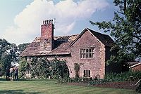 |
|
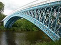
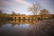
| Iron Bridge Aldford Iron Bridge Aldford Iron Bridge is a bridge crossing the River Dee north of the village of Aldford, Cheshire, England, linking the village with Eaton Hall, forming part of the Buerton Approach to the hall . It is a Grade I listed building.... |
Aldford Aldford Aldford is a village and civil parish in the county of Cheshire, England, south of Chester . It has a population of 213.The village lies on the east bank of the River Dee... |
53.1347 °N 2.870822 °W | 1824 | Bridge over the River Dee River Dee, Wales The River Dee is a long river in the United Kingdom. It travels through Wales and England and also forms part of the border between the two countries.... on the Buerton Approach to Eaton Hall Eaton Hall (Cheshire) Eaton Hall is the country house of the Duke of Westminster. It is set within a large estate south of the village of Eccleston, in Cheshire, England . The house is surrounded by formal gardens, parkland, farmland and woodland. The estate covers an area of about .The first substantial house was... . Built for the 1st Marquis of Westminster Robert Grosvenor, 1st Marquess of Westminster Robert Grosvenor, 1st Marquess of Westminster, KG was the son of the 1st Earl Grosvenor, whom he succeeded in 1802 as 2nd Earl Grosvenor. He was created Marquess of Westminster in 1831. He was an English Member of Parliament and an ancestor of the modern day Dukes of Westminster... . |
 |
|
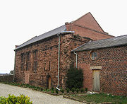
| Cruck barn Cruck A cruck or crook frame is a curved timber, one of a pair, which supports the roof of a building, used particularly in England. This type of timber framing consists of long, generally bent, timber beams that lean inwards and form the ridge of the roof. These posts are then generally secured by a... |
Arley Hall Arley Hall Arley Hall is a country house in the village of Arley, Cheshire, England, about south of Lymm and north of Northwich. It is home to the owner, Viscount Ashbrook and his family. The house is a Grade II* listed building, as is its adjacent chapel. Formal gardens to the southwest of the hall... |
53.3242°N 2.4901°W | Early 16th century | Former barn converted into an indoor riding school. | 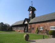 |
|
| Moss Hall Moss Hall, Audlem Moss Hall, Audlem, is a manor house to the northwest of Audlem, Cheshire, England. It has been designated by English Heritage as a Grade I listed building. Moss Hall is situated to the west of Audlem, overlooking the Shropshire Union Canal.... |
Audlem Audlem Audlem is a large village and civil parish located in the unitary authority of Cheshire East and the ceremonial county of Cheshire in the north west of England, approximately south of Nantwich. Close to the border with the neighbouring county of Shropshire, the village is eight miles east of... |
52.9930°N 2.5152°W | 1616 | Timber framed manor house, extensively renovated in 1902. | ||
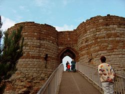
| Beeston Castle Beeston Castle Beeston Castle is a former Royal castle in Beeston, Cheshire, England , perched on a rocky sandstone crag above the Cheshire Plain. It was built in the 1220s by Ranulf de Blondeville, 6th Earl of Chester, , on his return from the Crusades... |
Beeston Beeston, Cheshire Beeston is a village and civil parish in the unitary authority of Cheshire West and Chester and the ceremonial county of Cheshire in the north of England. It is south of Tarporley, and close to the Shropshire Union Canal. Beeston Castle nearby is a spectacular clifftop ruin in the care of English... |
53.129012°N 2.691297°W | 1220s | Built by Ranulph de Blondeville, 4th Earl of Chester Ranulph de Blondeville, 4th Earl of Chester Ranulf de Blondeville, 6th Earl of Chester and 1st Earl of Lincoln , known in some references as the 4th Earl of Chester , was one of the "old school" of Anglo-Norman barons whose loyalty to the Angevin dynasty was consistent but contingent on the receipt of lucrative favours... . Partly demolished after the Civil War English Civil War The English Civil War was a series of armed conflicts and political machinations between Parliamentarians and Royalists... . Both the walls of the outer bailey, and the walls, towers and gatehouse of the inner baileys are listed Grade I. |
|
 |
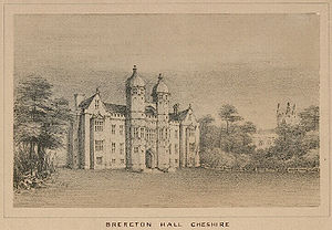
| Brereton Hall Brereton Hall Brereton Hall is a country house to the north of the village of Brereton Green, adjacent to St Oswald's Church, in the civil parish of Brereton, Cheshire, England. It has been designated by English Heritage as a Grade I listed building.-History:... |
Brereton Brereton, Cheshire Brereton is a civil parish, containing the hamlet of Brereton Green in the unitary authority of Cheshire East and the ceremonial county of Cheshire, England. It also contains the hamlets of Brereton Heath and Smethwick Green. According to the 2001 census, the population of the entire civil parish... |
53.1789°N 2.3324°W | 1586 | Built for Sir William Brereton. Alterations made in the 19th century, including removal of the cupola Cupola In architecture, a cupola is a small, most-often dome-like, structure on top of a building. Often used to provide a lookout or to admit light and air, it usually crowns a larger roof or dome.... s. |
 |
|
| Highfields Highfields, Buerton Highfields, Buerton is a small country house in the civil parish of Buerton, Cheshire, England. It has been designated by English Heritage as a Grade I listed building.... |
Buerton Buerton, Crewe and Nantwich Buerton is a village at and civil parish in the unitary authority of Cheshire East and the ceremonial county of Cheshire, England, about 7 miles south of the town of Nantwich and 1½ miles east of the village of Audlem, on the border with Shropshire... |
52.9654°N 2.4855°W | 1615 | Built for the Dodds family. Additions made in 1750 and 1897. |  |
|
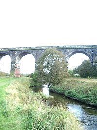
| Sankey Viaduct Sankey Viaduct right|thumb|225px|Sankey Viaduct crossing Sankey BrookThe Sankey Viaduct is a railway viaduct at Bradley Lane, Collins Green, Burtonwood parish, Warrington Borough, crossing the Sankey Brook into Earlestown, Newton le Willows, Metropolitan Borough of St Helens, Merseyside.-History:The viaduct was... |
Burtonwood Burtonwood Burtonwood and Westbrook is a civil parish in the outermost suburbs of Warrington in Cheshire, England. Historically within Lancashire, the name Burtonwood is known worldwide as the location of the former RAF Station Burtonwood military camp. Burtonwood village itself is a few miles away from the... |
53.44745°N 2.65076°W | 1830 | By George Stephenson George Stephenson George Stephenson was an English civil engineer and mechanical engineer who built the first public railway line in the world to use steam locomotives... for the Liverpool and Manchester Railway Liverpool and Manchester Railway The Liverpool and Manchester Railway was the world's first inter-city passenger railway in which all the trains were timetabled and were hauled for most of the distance solely by steam locomotives. The line opened on 15 September 1830 and ran between the cities of Liverpool and Manchester in North... . Earliest major railway viaduct Viaduct A viaduct is a bridge composed of several small spans. The term viaduct is derived from the Latin via for road and ducere to lead something. However, the Ancient Romans did not use that term per se; it is a modern derivation from an analogy with aqueduct. Like the Roman aqueducts, many early... in the world. |
 |
|
| Lower Carden Hall Lower Carden Hall Lower Carden Hall is a historic house in the civil parish of Carden, Cheshire, England. It has been designated by English Heritage as a Grade I listed building.... |
Carden Carden, Chester Carden is a small village and civil parish in the unitary authority of Cheshire West and Chester and the ceremonial county of Cheshire, England. The village of Carden consists of Higher Carden and Lower Carden... |
53.0637°N 2.8030°W | 15th century and later | Country house most of which is timber framed. | ||
| Combermere Abbey Combermere Abbey Combermere Abbey is a former monastery in Combermere Park, between Nantwich and Whitchurch in Cheshire, England, near the border with Shropshire.-Topomony:... |
Combermere Park | 52.993611°N 2.613889°W | 1563 | Country house, formerly abbot's house. Extended 1814–20. | 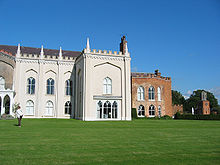 |
|
| Little Moreton Hall Little Moreton Hall Little Moreton Hall is a moated 15th and 16th-century half-timbered manor house southwest of Congleton, Cheshire. It is one of the finest examples of timber-framed domestic architecture in England. The house is today owned by the National Trust. It has been designated by English Heritage as a... |
Southwest of Congleton Congleton Congleton is a town and civil parish in the unitary authority of Cheshire East and the ceremonial county of Cheshire, England, on the banks of the River Dane, to the west of the Macclesfield Canal and 21 miles south of Manchester. It has a population of 25,750.-History:The first settlements in... |
53.1272°N 2.2518°W | 15th century | One of Britain's finest timber-framed moated manor houses. |  |
|
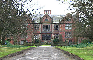
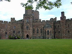
| Crewe Hall Crewe Hall Crewe Hall is a Jacobean mansion located near Crewe Green, east of Crewe, in Cheshire, England. Described by Nikolaus Pevsner as one of the two finest Jacobean houses in Cheshire, it is listed at grade I... |
Crewe Green Crewe Green Crewe Green is a small village and civil parish in the unitary authority of Cheshire East and the ceremonial county of Cheshire, England. The village lies 1½ miles to the east of the centre of Crewe... |
53.0827°N 2.3999°W | 1615–36 | Built for Sir Randolph Crewe Ranulph Crewe Sir Ranulph Crewe was an English judge and Chief Justice of the King’s Bench.-Early life and career:... , extended in the late 18th century and extensively restored Victorian restoration Victorian restoration is the term commonly used to refer to the widespread and extensive refurbishment and rebuilding of Church of England churches and cathedrals that took place in England and Wales during the 19th-century reign of Queen Victoria... after a fire in 1866. Considered to be one of the two finest Jacobean houses in Cheshire. |
.jpg) |
|
| Lyme Hall Lyme Park Lyme Park is a large estate located south of Disley, Cheshire, England. It consists of a mansion house surrounded by formal gardens, in a deer park in the Peak District National Park... |
Disley Disley Disley is a village and civil parish in the unitary authority of Cheshire East and the ceremonial county of Cheshire, England. It is located on the very edge of the Peak District, in the Goyt Valley, very close to the county boundary with Derbyshire at New Mills, and south of Stockport, Greater... |
53.3381°N 2.0547°W | c. 1570 with later additions | The largest house in Cheshire, built for the Legh family. | 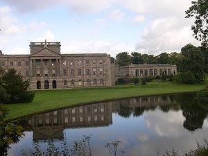 |
|
| Delves Hall Delves Hall Delves Hall, also known as Doddington Castle, is a fortified structure in Doddington Park to the north of Doddington Hall in the civil parish of Doddington, Cheshire, England. It has been designated by English Heritage as a Grade I listed building.... |
Doddington Doddington, Cheshire Doddington is a civil parish in the unitary authority of Cheshire East and the ceremonial county of Cheshire, England, which lies to the north east of Audlem and to the south of Crewe. Nearby villages include Blakenhall, Bridgemere, Checkley, Hatherton, Walgherton and Wybunbury... |
53.0197°N 2.4356°W | 1364 | Fortified tower built by Sir John Delves. | ||
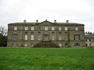
| Doddington Hall Doddington Hall, Cheshire Doddington Hall is a country house in Doddington Park in the civil parish of Doddington, Cheshire, England. It has been designated by English Heritage as a Grade I listed building.... |
Doddington | 53.0148°N 2.4342°W | 1777–98 | Built for Rev. Sir Thomas Broughton in neoclassical Neoclassical architecture Neoclassical architecture was an architectural style produced by the neoclassical movement that began in the mid-18th century, manifested both in its details as a reaction against the Rococo style of naturalistic ornament, and in its architectural formulas as an outgrowth of some classicizing... style. |
 |
|
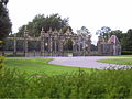
| Golden Gates, Eaton Hall Golden Gates, Eaton Hall The Golden Gates at Eaton Hall, Cheshire, England, stand at the eastern end of Belgrave Avenue . The gates with their overthrow, the screens at their sides and the associated wing lodges have been designated by English Heritage as a Grade I listed building. The gates stand in front of what... |
Eaton Park Eaton Hall (Cheshire) Eaton Hall is the country house of the Duke of Westminster. It is set within a large estate south of the village of Eccleston, in Cheshire, England . The house is surrounded by formal gardens, parkland, farmland and woodland. The estate covers an area of about .The first substantial house was... |
53.1404°N 2.8791°W | 18th century, c. 1880 |
The central pair of gates (Golden Gates) and the adjacent screen railings are by Robert and John Davies, 18th century. Side gates, screens and lodges by Alfred Waterhouse Alfred Waterhouse Alfred Waterhouse was a British architect, particularly associated with the Victorian Gothic Revival architecture. He is perhaps best known for his design for the Natural History Museum in London, and Manchester Town Hall, although he also built a wide variety of other buildings throughout the... , c. 1880. |
 |
|
| Farndon Bridge Farndon Bridge Farndon Bridge crosses the River Dee and the England-Wales border between the villages of Farndon, Cheshire, England and Holt, Wales . It has been designated by English Heritage as a Grade I listed building, and is a scheduled monument... |
Farndon Farndon, Cheshire Farndon is a village and civil parish in the unitary authority of Cheshire West and Chester and the ceremonial county of Cheshire, England. It is located on the banks of the River Dee, south of Chester, and close to the border with Wales... |
53.083373°N 2.879820°W | 1339 | Crosses the River Dee River Dee, Wales The River Dee is a long river in the United Kingdom. It travels through Wales and England and also forms part of the border between the two countries.... and the England-Wales border between the villages of Farndon and Holt Holt, Wales Holt is a medieval market town and local government community in the county borough of Wrexham, Wales. It is situated on the border with England. Holt Castle was begun by Edward I shortly after the English invasion of Wales in 1277.-Area:... . |
 |
|
| Gawsworth Old Hall | Gawsworth Gawsworth Gawsworth is a civil parish and village in the unitary authority of Cheshire East and the ceremonial county of Cheshire, England. It is one of the eight ancient parishes of Macclesfield Hundred. Twenty acres of the civil parish were transferred to Macclesfield civil parish in 1936The country houses... |
53.2238°N 2.1638°W | 1480, remodelled 1701 |
Partly timber framed, partly in brick, for the Fitton family. |  |
|
| Old Rectory Gawsworth Old Rectory Gawsworth Old Rectory is a house in the village of Gawsworth, Cheshire, England. It has been designated by English Heritage as a Grade I listed building... |
Gawsworth | 53.2240°N 2.1667°W | 15th–16th century | Timber framed with the hall open to the roof. North wing added 1872. Originally a rectory, now a private house. |
||
| Belmont Hall Belmont Hall, Cheshire Belmont Hall, Cheshire, is a country house to the northwest of the village of Great Budworth, Cheshire, England. It has been designated by English Heritage as a Grade I listed building. The house stands to the north of the A559 road... |
Great Budworth Great Budworth Great Budworth is a civil parish and village, approximately north of Northwich, England, within the unitary authority of Cheshire West and Chester and the ceremonial county of Cheshire. It lies off the A559 road, east of Comberbach, northwest of Higher Marston and southeast of Budworth Heath... |
53.3011°N 2.5198°W | 1755 | Country house by James Gibbs James Gibbs James Gibbs was one of Britain's most influential architects. Born in Scotland, he trained as an architect in Rome, and practised mainly in England... ; now a school. |
||
| Halton Castle Halton Castle Halton Castle is in the former village of Halton which is now part of the town of Runcorn, Cheshire, England. The castle is situated on the top of Halton Hill, a sandstone prominence overlooking the village... |
Halton Halton, Cheshire Halton, formerly a separate village, is now part of the town of Runcorn, Cheshire, England. The name Halton has been assumed by the Borough of Halton, which includes Runcorn, Widnes and some outlying parishes.-Geography:... |
53.3331°N 2.6957°W | c. 1070 | Castle on a sandstone outcrop. Now a ruin. |  |
|
| Haslington Hall Haslington Hall Haslington Hall is a country house located in open countryside 1 km to the east of the village of Haslington, Cheshire, England. It has been designated by English Heritage as a Grade I listed building.-Early history:... |
Haslington Haslington Haslington is a village and civil parish in the unitary authority of Cheshire East and the ceremonial county of Cheshire, England. It lies about 2 miles north-east of the much larger railway town of Crewe and approximately 4 miles south of Sandbach... |
53.1006°N 2.3776°W | 1545 with later alterations | Timber framed house built by Admiral Sir Francis Vernon. |  |
|
| Ince Manor Ince Manor Ince Manor or Ince Grange is a former monastic grange in the village of Ince in Cheshire, England. The remains of the manor house, consisting of the old hall, and the monastery cottages have been designated by English Heritage as a Grade I listed building, and a scheduled monument... |
Ince Ince Ince is a village and civil parish in the unitary authority of Cheshire West and Chester and the ceremonial county of Cheshire, England. It is situated immediately to the east of the Stanlow Oil Refinery. It shares Ince and Elton railway station with the village of Elton, which it runs into... |
53.2831°N 2.8270°W | Late 13th century and later | Former monastic grange. The hall and the monastery cottages remain. |
 |
|
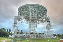
| Lovell Telescope Lovell Telescope The Lovell Telescope is a radio telescope at Jodrell Bank Observatory, near Goostrey, Cheshire in the north-west of England. When it was constructed in 1955, the telescope was the largest steerable dish radio telescope in the world at 76.2 m in diameter;it is now the third largest, after the... |
Jodrell Bank Observatory, near Goostrey Goostrey Goostrey is an old farming village and civil parish in the unitary authority of Cheshire East and the ceremonial county of Cheshire, England. It is located off Junction 18 of the M6 motorway, near Jodrell Bank Observatory. According to the 2001 Census, the civil parish had a total population of... |
53.237°N 2.30715°W | 1952–57 | When built, it was the largest steerable dish radio telescope Radio telescope A radio telescope is a form of directional radio antenna used in radio astronomy. The same types of antennas are also used in tracking and collecting data from satellites and space probes... in the world. |
 |
|
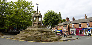
| Lymm Cross Lymm Cross Lymm Cross is in the village of Lymm, Cheshire, England. It has been designated by English Heritage as a Grade I listed building.The cross dates from the early to the middle 17th century and it was restored in 1897. It is constructed of sandstone and stands on an artificially stepped... |
Lymm Lymm Lymm is a large village and civil parish within the Warrington borough of Cheshire, in North West England. Lymm was an urban district of Cheshire from 1894 to 1974. The civil parish of Lymm incorporates the hamlets of Booths Hill, Broomedge, Church Green, Deansgreen, Heatley, Heatley Heath, Little... |
53.3811°N 2.4776°W | 17th century | Restored Victorian restoration Victorian restoration is the term commonly used to refer to the widespread and extensive refurbishment and rebuilding of Church of England churches and cathedrals that took place in England and Wales during the 19th-century reign of Queen Victoria... 1897. |
 |
|
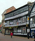
| Crown Hotel Crown Hotel, Nantwich The Crown Hotel, also known as the Crown Inn, is a timber-framed, black-and-white hotel and public house located at 24–26 High Street in the town of Nantwich in Cheshire, England. The present building dates from shortly after 1583... |
Nantwich Nantwich Nantwich is a market town and civil parish in the Borough of Cheshire East and the ceremonial county of Cheshire, England. The town gives its name to the parliamentary constituency of Crewe and Nantwich... |
53.0673°N 2.5226°W | 1580s | Timber framed inn built after the fire of 1583. Now a public house and hotel. |
 |
|
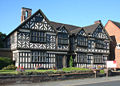
| Churche's Mansion Churche's Mansion Churche's Mansion is a timber-framed, black-and-white Elizabethan mansion house at the eastern end of Hospital Street in Nantwich, Cheshire, England... |
Nantwich | 53.0655°N 2.5144°W | 1577 | Timber framed mansion house. Pevsner describes it as "an outstanding piece of decorated half-timber architecture". |
 |
|
| Peckforton Castle Peckforton Castle Peckforton Castle is a country house built in the style of a medieval castle. It stands in woodland at the north end of Peckforton Hills northwest of the village of Peckforton, Cheshire, England. It has been designated by English Heritage as a Grade I listed building... |
Peckforton Peckforton Peckforton is a scattered settlement and civil parish in the unitary authority of Cheshire East and the ceremonial county of Cheshire, England. The settlement is located to the north east of Malpas and miles to the west of Nantwich. The total population of the civil parish is somewhat over 100... |
53.1175°N 2.6990°W | 1844–50 | Country house built in the style of a medieval castle by Anthony Salvin Anthony Salvin Anthony Salvin was an English architect. He gained a reputation as an expert on medieval buildings and applied this expertise to his new buildings and his restorations... for John Tollemache, 1st Baron Tollemache John Tollemache, 1st Baron Tollemache John Jervis Tollemache, 1st Baron Tollemache , was a British Conservative Member of Parliament and a major landowner and estate manager in Cheshire.-Personal life and career:... . Now a hotel. |
 |
|
| Stable Block Peover Hall Stable Block Peover Hall Stable Block is in the grounds of Peover Hall, Cheshire, England. It has been designated by English Heritage as a Grade I listed building.-History:... |
Peover Hall Peover Hall Peover Hall is a country house in the civil parish of Peover Superior, commonly known as Over Peover, Cheshire, England. It has been designated by English Heritage as a Grade II* listed building.-History:... |
53.2573°N 2.3418°W | 1654 | A gift from Mrs Ellen Mainwaring to her son Thomas. Elaborate screens to stalls. | ||
| Norton Priory Norton Priory Norton Priory is a historic site in Norton, Runcorn, Cheshire, England, comprising the remains of an abbey complex dating from the 12th to 16th centuries, and an 18th-century country house; it is now a museum. The remains are a scheduled ancient monument and have been designated by English... |
Near Runcorn Runcorn Runcorn is an industrial town and cargo port within the borough of Halton in the ceremonial county of Cheshire, England. In 2009, its population was estimated to be 61,500. The town is on the southern bank of the River Mersey where the estuary narrows to form Runcorn Gap. Directly to the north... |
53.3423°N 2.6799°W | 13th century and later | A priory, then an abbey and later a country house. Now a ruin and a museum. | 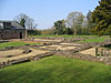 |
|
| Gatehouse | Saighton Saighton Saighton is a civil parish and village in the unitary authority of Cheshire West and Chester and the ceremonial county of Cheshire, England, a few miles south of Chester... |
53.1503°N 2.8342°W | c. 1489 | Monastic grange for St Werburgh's Abbey, Chester. Only the gatehouse remains and this is now part of a school. | 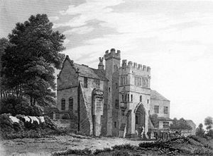 |
|
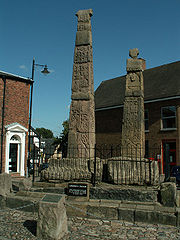
| Crosses Sandbach Crosses The Sandbach Crosses are two 9th-century Anglo-Saxon stone crosses now erected in the market place in the town of Sandbach, Cheshire, England. They are unusually large and elaborate examples of the type and have been designated by English Heritage as a Grade I listed building, and are a... |
Sandbach Sandbach Sandbach is a market town and civil parish in the unitary authority of Cheshire East and the ceremonial county of Cheshire, England. The civil parish contains four settlements; Sandbach itself, Elworth, Ettiley Heath and Wheelock.... |
53.14402°N 2.36209°W | 9th century | Pair of carved Anglo-Saxon Anglo-Saxon architecture Anglo-Saxon architecture was a period in the history of architecture in England, and parts of Wales, from the mid-5th century until the Norman Conquest of 1066. Anglo-Saxon secular buildings in Britain were generally simple, constructed mainly using timber with thatch for roofing... crosses. |
 |
|
| Old Hall Hotel Old Hall Hotel, Sandbach The Old Hall Hotel, Sandbach is in the High Street in the centre of Sandbach, Cheshire, England . It has been designated by English Heritage as a Grade I listed building.-Early history:... |
Sandbach Sandbach Sandbach is a market town and civil parish in the unitary authority of Cheshire East and the ceremonial county of Cheshire, England. The civil parish contains four settlements; Sandbach itself, Elworth, Ettiley Heath and Wheelock.... |
53.144°N 2.363°W | 1656 | Large timber framed building, now a hotel. | 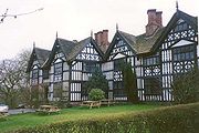 |
|
| Sutton Hall Sutton Hall, Vale Royal Sutton Hall is to the south of the village of Sutton Weaver in Cheshire, England. It has been designated by English Heritage as a Grade I listed building.... |
Sutton Weaver Sutton Weaver Sutton Weaver is a small village in the civil parish of Sutton, Cheshire West and Chester, England . It is in the unitary authority of Cheshire West and Chester, 2 miles north-east of Frodsham.-See also:*Sutton Hall, Vale Royal... |
53.3067°N 2.6844°W | Late 15th or early 16th century, later extended | Internally are two superimposed great halls. | ||
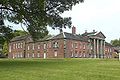
| Tabley House Tabley House Tabley House is a former stately home in Tabley Inferior , some to the east of the town of Knutsford, Cheshire, England. The house has been designated by English Heritage as a Grade I listed building. It was built between 1761 and 1769 for Sir Peter Byrne Leicester, to replace an older... |
Knutsford Knutsford Knutsford is a town and civil parish in the unitary authority area of Cheshire East and the ceremonial county of Cheshire, in North West England... |
53.2931°N 2.4225°W | 1767 | Palladian Palladian architecture Palladian architecture is a European style of architecture derived from the designs of the Venetian architect Andrea Palladio . The term "Palladian" normally refers to buildings in a style inspired by Palladio's own work; that which is recognised as Palladian architecture today is an evolution of... mansion by John Carr. Now owned by the University of Manchester University of Manchester The University of Manchester is a public research university located in Manchester, United Kingdom. It is a "red brick" university and a member of the Russell Group of research-intensive British universities and the N8 Group... . |
||
| Tatton Hall Tatton Hall Tatton Hall is a country house in Tatton Park near Knutsford, Cheshire, England . It has been designated as a Grade I listed building which is owned by the National Trust and administered in conjunction with Cheshire East Council.-History:... |
Knutsford | 53.3304°N 2.3835°W | 1791; completed 19th century | Neoclassical country house. |  |
|
| Utkinton Hall Utkinton Hall Utkinton Hall is a country house to the southeast of the village of Utkinton, Cheshire, England. It has been designated by English Heritage as a Grade I listed building.... |
Utkinton Utkinton thumb|200px|Map of civil parish of Utkinton within the former borough of Vale RoyalUtkinton is a civil parish and small village in the unitary authority of Cheshire West and Chester and the ceremonial county of Cheshire, England. It is approximately 8 miles west of Winsford and north of Tarporley... |
53.1769°N 2.6705°W | Medieval core but most of it dates from the early 17th century | Large manor house for the Done family. | ||
| Town Hall Warrington Town Hall Warrington Town Hall is in the town of Warrington, Cheshire, England. It consists of a house, originally called Bank Hall, flanked by two detached service wings at right angles to the house, one on each side. The house and the service wings have each been designated by English Heritage as... |
Warrington Warrington Warrington is a town, borough and unitary authority area of Cheshire, England. It stands on the banks of the River Mersey, which is tidal to the west of the weir at Howley. It lies 16 miles east of Liverpool, 19 miles west of Manchester and 8 miles south of St Helens... |
53.3897°N 2.5997°W | 1750 | House for Thomas Patten by James Gibbs. Pevsner describes it as "the finest house of its date in south Lancashire". The detached service wings are also listed Grade I. |
|
 |
| Winnington Hall Winnington Hall Winnington Hall is a former country house in Winnington, now a suburb of Northwich, Cheshire, England . It has been designated by English Heritage as a Grade I listed building... |
Winnington Winnington Winnington is a small, mainly residential area of the town of Northwich in Cheshire, England.-Industry:Winnington is the home to Brunner Mond UK chemical works, where soda ash is created. Polythene, the material used in many plastic items , was first made at the chemical works by R.O. Gibson and... |
53.2686°N 2.5336°W | c.1600; 1775 | Older wing timber framed; newer wing in stone by Samuel Wyatt Samuel Wyatt Samuel Wyatt was an English architect and engineer. A member of the Wyatt family, which included several notable 18th and 19th century English architects, his work was primarily in a neoclassical style.-Career:... . |
||