
Mono-Inyo Craters
Encyclopedia
The Mono–Inyo Craters is a volcanic chain of craters, domes and lava flows in Eastern California
that stretches 25 miles (40.2 km) from the northwest shore of Mono Lake
to the south of Mammoth Mountain
. The chain is located in Mono County
in the U.S. state
of California. Mono Lake Volcanic Field forms the northernmost part of the chain and consists of two volcanic islands in the lake and one cinder cone
volcano on its northwest shore. Most of the Mono Craters, which make up the bulk of the northern part of the Mono–Inyo chain, are phreatic
(steam explosion) volcanoes that have since been either plugged or over-topped by rhyolite
domes and lava flows. The Inyo Craters form much of the southern part of the chain and consist of phreatic explosion pits, and rhyolitic lava flows and domes. The southernmost part of the chain consists of fumarole
s and explosion pits on Mammoth Mountain and a set of cinder cones south of the mountain; the latter are called the Red Cones
.
Eruptions along the narrow fissure system under the chain began in the west moat of Long Valley Caldera
400,000 to 60,000 years ago. Mammoth Mountain was formed during this period. Multiple eruptions from 40,000 to 600 years ago created the Mono Craters and eruptions 5,000 to 500 years ago formed the Inyo Craters. Lava flows 5,000 years ago built the Red Cones, and explosion pits on Mammoth Mountain were excavated in the last 1,000 years. Uplift of Paoha Island
in Mono Lake about 250 years ago is the most recent activity. These eruptions most likely originated from small magma bodies rather than from a single, large magma chamber
like the one that produced the massive Long Valley Caldera eruption 760,000 years ago. During the past 3,000 years, eruptions have occurred every 250 to 700 years. In 1980, a series of earthquakes and uplift within and south of Long Valley Caldera indicated renewed activity in the area.
The region has been used by humans for centuries. Obsidian
was collected by Mono Paiutes
for making sharp tools and arrow points. Glassy rock continues to be removed in modern times for use as commercial scour and yard decoration. Mono Mills
processed timber felled on or near the volcanoes for the nearby boomtown Bodie
in the late 19th to early 20th centuries. Water diversions into the Los Angeles Aqueduct
system from their natural outlets in Mono Lake started in 1941 after a water tunnel was cut under the Mono Craters. Mono Lake Volcanic Field and a large part of the Mono Craters gained some protection under Mono Basin National Forest Scenic Area in 1984. Resource use along all of the chain is managed by the United States Forest Service
as part of Inyo National Forest
. Various activities are possible along the chain, including hiking, bird watching, canoeing, skiing, and mountain biking.
that sit along a narrow, north–south-trending fissure system that extends from the north shore of Mono Lake
, through the western moat of Long Valley Caldera
, and south of Mammoth Mountain
. The chain is located in Inyo National Forest
and Mono County, California
, and the nearest incorporated community is Mammoth Lakes, California
. The Mono Craters are located in Mono Basin
, itself part of the Great Basin
.
s and various explosion pits and other associated volcanic features. The domes of the chain lie on a roughly north–south-trending arc that is concave to the west and located south of Mono Lake. The highest of the Mono Craters domes is Crater Mountain (elevation 9,172 feet or 2,796 m), which rises 2400 feet (731.5 m) above Pumice Valley to the west. Associated volcanic features are located in Mono Lake (Paoha
and Negit Island
s) and on its north shore (Black Point). The coulees cluster north and south of the overlapping chain of domes. Craters exist at the top of most domes and on flat land south of them.
s, including Deadman Creek Dome, Glass Creek Dome, Obsidian Dome, and Wilson Butte. These domes are composed of gray rhyolite
, frothy pumice
, and black obsidian
. The Mono–Inyo Craters volcanic chain extends into Long Valley Caldera but is not related to the caldera's volcanism.
system responsible for creating the craters, volcanoes and lava flows. These include a north–south trend of fault scarp
s up to 20 feet (6.1 m) high and pull-apart cracks or fissures in the earth. These fissures are not technically faults because little or no vertical or horizontal movement has occurred along them. Most notable among these is "Earthquake Fault", a fissure up to 10 feet (3 m) wide that cuts 60 to 70 ft (18.3 to 21.3 m) into glassy rhyolite lava flows. The fissure was formed by stretching induced by the intrusion of the Inyo dike. Stairs to the bottom of the fissure were removed after being damaged by earthquakes in 1980.
Several Mono–Inyo-related explosion pits are on Mammoth Mountain. The Red Cones
, south of Mammoth Mountain, are basaltic cinder cone
s and are the southernmost part of the Mono–Inyo Craters volcanic chain.
of the North American Desert
. The desert environment of Mono Basin receives about 14 inches (35.6 cm) of precipitation a year. Annual precipitation around Mammoth Lakes, which is close to the Inyo Craters, is about 23 inches (58.4 cm). Moisture travels over the Sierra crest from the Pacific Ocean through the San Joaquin Gap. Temperatures in Mono Basin range from average winter lows of 20 to 28 °F (−7 to −2 °C) to average summer highs of 75 to 84 °F (23.9 to 28.9 C). Temperatures near the Inyo Craters and Mammoth Lakes area range from winter average lows of 16 to 21 °F (−9 to −6 °C) to summer average highs of 70 to 78 °F (21.1 to 25.6 C).
Most of the surface of the Mono Craters is barren but its slopes are covered by Jeffrey Pine
forest and partial greenery. Pumice Valley, directly to the west, is covered by sagebrush
scrubland. The soil consists primarily of deep pumice, which does not hold water well. Mycorrhiza
l fungi in the soil invade the roots of Jeffrey Pine trees in a symbiotic relationship that helps the pine absorb water and provides nutrients to the fungi. Jeffrey Pine forests also surround the Inyo Craters and Mammoth Mountain. Mule deer
, coyote
s, black bears
, yellow-bellied marmot
s, raccoon
s and mountain lions all have ranges that are coincident with forests that cover parts of the Mono–Inyo craters.
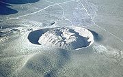 Panum Crater
is the northernmost volcano in the sequence and is a good example of both a tuff ring and a rhyolite dome. Its structure is twofold; an outer tuff ring (forming a classic crater) and an inner plug, or dome of rhyolite, pumice and obsidian created from lavas. In this case, heat from the magma feeding Panum flashed groundwater to steam to create the tuff ring before lava reached the surface. Other Mono Craters also were formed in this manner, but their plug domes grew larger than their tuff ring craters. The domes have steep sides and are flanked by slopes of scree
consisting of large angular and glass-rich rocks. Devil's Punch Bowl, located south of the main dome complex, stopped forming at an earlier stage of development. It is a 1200 feet (365.8 m) wide and 140 feet (42.7 m) deep explosion pit with a much smaller glass dome on its floor.
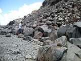
The large North and South Coulee and the smaller Northwest Coulee consist of obsidian-rich rhyolite. They were formed from slow-moving lava that had a thin and brittle crust. Once the flow stopped, it formed steep sided tongues of sharp and angular rock that are typically 200 to 300 ft (61 to 91.4 m) thick and have scree piles along their base. South Coulee is 2.25 miles (3.6 km) long, 0.75 miles (1.2 km) wide and has a volume of 0.1 cubic mile (0.4168181825 km³); making it the largest Mono Craters coulee in volume. South Coulee originates from the crest of the Mono Domes, about 3 miles (4.8 km) from the southern end, flows down its east and west flanks and terminates at its foot. North Coulee is nearly as large, flows mostly to the east and terminates in a divided pair of lobes. Northwest Coulee is located northwest of North Coulee and was intruded by Upper Dome after the coulee solidified. Permanent pockets of ice from snowmelt have been found 75 to 147 ft (22.9 to 44.8 m) inside the coulees and domes.
of the Sierra Nevada mountain range. Volcanism and seismic activity in eastern California are a result of two major geologic processes: northwest movement of the Pacific Plate
with respect to the North American Plate
along the San Andreas Fault
system near the coast, and east–west extension of the crust that formed the Basin and Range Province. In the Long Valley region, where the craters are located, basin and range
extension encroaches onto the thick and stable crust of the Sierra Nevada.
Basement rock under the Mono–Inyo chain consists of the same granitic
and metamorphic rock
that make up the Sierra Nevada. Above that layer are basalt
ic grading to rhyolitic
volcanic rocks that are 3.5 million to less than 760,000 years old. Volcanism occurred north of the chain, in the Bodie Hills
, as far back as 28 million years. Nearly all the rock east of the Sierra Nevada in the Mono Basin area is volcanic in origin.
Volcanoes erupted from 3.6 to 2.3 million years ago near what is now Long Valley. Rhyolitic eruptions occurred in and around Glass Mountain
in the same area from 2.1 to 0.8 million years ago. Volcanic ash from the massive (600 cubic kilometres (143.9 cu mi) of ejecta) eruption of Long Valley Caldera
some 760,000 years ago is preserved in the thick Bishop Tuff
that covers much of the region.
Eruptions of basalt
and andesite
400,000 to 60,000 years ago in the west moat of Long Valley Caldera were the first activity associated with the Mono–Inyo Craters system. Eruptions around 300,000 years ago filled the west moat with 800 feet (243.8 m) of basaltic lava. Basaltic and andesitic eruptive activity then moved to Mono Basin and lasted from 40,000 to 13,000 years ago.
Seismic data indicate that a magma chamber
with an estimated volume of 200 cubic kilometre exists 8 to 10 km (5 to 6.2 mi) directly below the Mono Craters. About 200 metres (656.2 ft) of subsidence has occurred within a ring fracture system centered on Pumice Valley west of the chamber in the last 700,000 years. The Mono Craters sit atop a 12 kilometres (7.5 mi)-long arc on the eastern side of the 18 kilometres (11.2 mi)-wide ring-fracture system. Magma feeding the domes may have exploited arc-shaped fissures around an intrusion of granitic rock deep below the chain. This magma chamber is separate from the magma chamber under Long Valley Caldera. The recent eruptions of the Mono Craters have been similar in volume and nearly identical in composition ("crystal-poor high-silica rhyolite") to those of Glass Mountain that preceded the Long Valley Caldera-forming eruption. It has been suggested that the Mono Craters volcanism may represent an early stage in the development of a future caldera.
Repeated eruption of dacite
and rhyodacite
from vents on the southwest rim of the caldera from 220,000 to 50,000 years ago formed Mammoth Mountain, a volcano composed of overlapping lava dome
s. Eruptions of dacite and rhyodacite occurred in Mono Basin from 100,000 to 6,000 years ago.
. Several eruptive episodes from 1,600 to 270 years before present
in Mono Lake formed Negit Island. The magma reservoir feeding the Mono Lake Volcanic Field is unrelated to the Mono Craters magma reservoir.
Basaltic andesite
lava built the Red Cones, two small cinder cone
s 10 kilometres (6.2 mi) southwest of Mammoth Lakes, around 8,500 before present. The five Mammoth Mountain Craters are a set of explosion pits that trend west-north-west for 2.5 kilometres (1.6 mi) near the northern flank of Mammoth Mountain.
None of the Mono Craters near the lake show the effects of wave erosion, but a hill at the southern end of the field shows what Israel Russell called a "beach line
". The present elevation of this beach line is the level of the Mono Lake high stand before the formation of the northern Mono Craters, plus any surface deformation that has happened since that time. Stream-rounded stones are found on the volcanoes, and were lifted up as the volcanoes grew. Although glaciers were present throughout the Sierra Nevada, they did not reach as far down as the Mono Craters.
The most recent eruptive episode on the Mono Craters occurred sometime between the years 1325 and 1365. A vertical sheet-like mass of magma, called a dike, caused groundwater
to explosively flash to steam, creating a line of vents 4 miles (6.4 km) long. A mix of ash and pulverized rock, called tephra, covered about 3000 square miles (7,770 km²) of the Mono Lake region. The tephra were carried by the wind and deposited in a layer 8 inches (20.3 cm) deep 20 miles (32.2 km) from the vents and 2 inches (5.1 cm) deep 50 miles (80.5 km) away.
Pyroclastic flow
s of hot clouds of gas, ash and pulverized lava erupted from these vents in narrow tongues that extended up to 5 miles (8 km) away and covered 38 square miles (98.4 km²). Rhyolite lava oozed out of the vents to form several steep-sided domes, including Panum Dome and the much larger North Coulee flow. The youngest domes and coulees are 600 to 700 years old and are, therefore, the youngest mountains in North America.
 Explosive eruptions later emanated from three separate vents. Pieces of molten and solid rock were ejected, small craters were formed, and a tall eruption column rose above the vents. Pumice and ash covered an extensive area downwind, and about 1 inches (2.5 cm) of tephra was deposited where the town of Mammoth Lakes, California
, now sits. A pyroclastic flow from South Deadman vent traveled about 6 kilometres (3.7 mi).
Some of the open pits were filled with thick and slow-moving lava to form the South Deadman Creek, Glass Creek and Obsidian Flow domes. Others, such as the Inyo Crater Lakes near Deer Mountain, remained open and were later partially filled with water. Smaller explosion pits on the north side of Mammoth Mountain were also formed at this time. In the past 6,000 years, approximately 0.8 cubic kilometre (0.191930206883429 cu mi) of magma has been erupted from the Inyo part of the chain.
The last recorded volcanic activity in the chain was at Mono Lake between the years 1720 and 1850. An intrusion of magma below the lake pushed lakebed sediments upward to form Paoha Island
. Exposed rhyolite is on the north part of the island, and a group of seven dacite
cinder cones and a lava flow are on the northeastern corner. Steam rose in columns hundreds of feet high (tens of meters) from Hot Spring Cove on the island and the spring water was 150 °F (65.6 °C) when geologist Israel Russell
visited the island in the early 1880s.
gathered obsidian
from the Mono–Inyo Craters to make sharp tools and arrow points. Unworked obsidian was carried by the Mono Paiutes over passes in the Sierra Nevada to trade with other Native American
groups. Chips of Mono–Inyo obsidian can still be found at many ancient mountain campsites.
Gold rush
–related boomtown
s sprang up near Mono Basin in the 19th century to exploit bonanzas. The largest of these, Bodie
(north of Mono Lake), was founded in the late 1870s and grew large enough to need a tree mill, which was located at Mono Mills
, immediately northeast of Mono Domes. Trees directly around the domes and on their slopes were felled to provide timber for the mill.
As part of the California Water Wars
, the Los Angeles Department of Water and Power
purchased large tracts of land in the 1930s within Mono Basin and Owens Valley
in order to control water right
s. Excavation of an 11.5 miles (18.5 km) water tunnel under the southern part of the Mono Craters dome complex started in 1934 and was completed in 1941. Tunnel workers had to deal with loose and often water-charged gravels, pockets of carbon dioxide
gas and flooding. About one man was lost for each mile excavated. Water diverted from its natural outlet in Mono Lake passes through the tunnel on its way to the Los Angeles Aqueduct
system.
The United States Pumice Company, based in Chatsworth, California
, has mined the area for pumice
since 1941. The company markets the pumice in slabs for use in commercial scouring and in large irregular chunks sold as yard decoration.
Exploratory drilling for geothermal power
occurred near the Mono Craters on the south shore of Mono Lake in 1971. The wells did not show promising results, so the effort was abandoned.
visited Mono Basin in the 1860s and wrote about Mono Lake, but did not mention any of the Mono–Inyo Craters except for the lake's two volcanic islands. He wrote in Roughing It
(1872) that the lake was in a "lifeless, hideous desert ..." that was the "loneliest spot on earth ... little graced with the picturesque."
Naturalist John Muir
explored the area in 1869. He described the "Mono Desert" as a "... country of wonderful contrasts. Hot deserts bounded by snow-laden mountains,—cinders and ashes scattered on glacier-polished pavements,—frost and fire working together in the making of beauty. In the lake are several volcanic islands, which show that the waters were once mingled with fire." Muir described the Mono Craters as "... heaps of loose ashes that have never been blest by either rain or snow ..."
In the spring of 1881 and the fall of 1882, geologist Israel Russell
studied the area as a side-trip during his field research of Lake Lahontan
, a now dry lake that covered much of nearby Nevada during the last glacial period
. His Quaternary History of the Mono Valley (1889), which included a topographic survey by Willard D. Johnson, was the first thorough scientific description of Mono Lake and its volcanic features.
Russell named the Mono Craters and wrote: "The attention of every one who enters Mono Valley is at once attracted by the soft, pleasing colors of these craters as well as by the symmetry and beauty of their forms. They are exceptional features in the scenery of the region, and are rendered all the more striking by their proximity to the angular peaks and rugged outlines of the High Sierra."
lands, surrounds Mono Lake and its two volcanic islands, Black Point, Panum Crater and much of the northern half of the Mono Craters. Litigation and outreach by the Mono Lake Committee
, the National Audubon Society
and other conservation groups has helped to slow water diversions from tributaries feeding Mono Lake.
A series of earthquakes inside Long Valley Caldera, coincidently starting two weeks after the May 1980 eruption of Mount St. Helens
in Washington, alerted geologists to the possibility of renewed volcanic activity in the region. Four magnitude
6 earthquakes struck the southern margin of Long Valley Caldera in an area that was close to the Mono–Inyo fissure system. The caldera floor had also uplifted by 10 inches (25.4 cm) in five years. Upward movement of magma under the caldera was thought to be the cause of the earthquakes and uplift.
Persistent earthquake swarm
s in 1982 prompted the United States Geological Survey
(USGS) to issue a "potential volcanic hazard" notice for Long Valley. That same year, permanent monitoring of the area by the Long Valley Observatory
started. The hazard notice was lifted in 1984 after USGS scientists concluded that magma had been injected into fissures below Mammoth Mountain but had congealed underground. From 1990 to 1996, 150 acres (60.7 ha) of trees were killed on Mammoth Mountain by 20% to 95% concentrations of carbon dioxide
(CO2) in the soil (less than 1% is normal). Chemical analysis of the CO2 indicated it was derived from magma.
and Mount Shasta
. These areas are in the program because they have been active in the last 2,000 years and have the ability to produce explosive eruptions.
About 20 eruptions have occurred on the Mono–Inyo Craters chain at intervals of 250 to 700 years during the past 5,000 years. Seismic soundings and lava composition indicate that these eruptions most likely originated from discrete and small magma bodies. The rate of eruption over the last 1,000 years has increased, with at least 12 eruptions occurring.
All eruptions in the past 5,000 years from the Mono–Inyo Craters have expelled less than 1 cubic kilometre (0.239912758604287 cu mi) of magma
. Future eruptions in the area will likely be similar in size to the small to moderate events of the past 5,000 years. There is a one in 200 chance (0.5%) per year of an eruption occurring along the chain. An eruption in the foreseeable future is probably more likely along the Mono–Inyo chain than an unrelated eruption inside Long Valley Caldera.
Severe damage from super-heated flows of gas, ash and pulverized rock (pyroclastic flow
s and surges) may occur at least 15 kilometres (9.3 mi) from an explosive eruption. The amount of damage depends on vent location, topography, and volume of magma erupted. Pyroclastic flows from vents on Mammoth Mountain or other high vent could travel farther by gaining extra momentum from their descent. Valleys along the route will be more impacted than ridges but flows and surges could overtop some ridges. Eruptions near snowpacks may produce lahar
s of mud and ash that devastate valleys and watersheds. Steam blast eruptions under a lake could form large waves capable of flooding nearby areas and starting mudflows.
Basalt lava flows may extend more than 50 kilometres (31.1 mi) from their vent. Dacite and rhyolite lavas produce short, thick flows that rarely extend more than 5 kilometres (3.1 mi) from their vent. Mound-shaped features called lava domes are often created from these flows. Rock fragments thrown from a growing lava dome may reach 5 to 10 km (3.1 to 6.2 mi) from the dome. A partial collapse of the steep-sided growing dome can send pyroclastic flows outward at least 5 kilometres (3.1 mi). Taller domes tend to form larger pyroclastic flows that travel farther.
. A bookstore, an information desk staffed by USDA Forest Service Rangers, and museum exhibits help to orient visitors. The Mono Lake Committee
has a staffed office and visitor information center in Lee Vining
on the corner of U.S. Route 395 and 3rd Street. Information on camping, hiking, guided and self-guided tours can all be obtained at either location.
U.S. 395 is a scenic route
that roughly parallels the Mono–Inyo Craters volcanic chain. California State Route 120
provides access to the northern and eastern parts of the Mono Domes, including Panum Crater
. Mammoth Scenic Loop (also called Dry Creek Road), provides access to the Inyo Crater lakes and some of the Inyo domes.
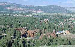
The town of Mammoth Lakes
, located near the southern end of the chain and Mammoth Mountain
, is the largest populated area nearby. Mammoth Mountain Ski Area
is located nearby and gondola
rides can be taken year-round (weather permitting) to the mountain's summit. The summit of Mammoth Mountain provides panoramic views of the craters and domes of the Mono–Inyo volcanic chain, Mono Lake, the Sierra Nevada and Long Valley Caldera.
Mono Lake
itself has its own set of activities, including walking tours among towers of tufa
, boat tours of the lake, and birdwatching opportunities. The lake is too salty to support any fish, but fishing is possible in streams that feed Mono Lake. Additional activities include hiking around and on the craters and domes, and mountain biking outside of the Scenic Area boundaries.
Eastern California
Eastern California is a term that refers to the eastern region of California, United States. It can refer to either the strip to the east of the crest of the Sierra Nevada, or to the easternmost counties of California.-Culture and history:...
that stretches 25 miles (40.2 km) from the northwest shore of Mono Lake
Mono Lake
Mono Lake is a large, shallow saline lake in Mono County, California, formed at least 760,000 years ago as a terminal lake in a basin that has no outlet to the ocean...
to the south of Mammoth Mountain
Mammoth Mountain
Mammoth Mountain is a lava dome complex west of the town of Mammoth Lakes, California in the Inyo National Forest of Madera County and Mono County. It is home to a large ski area on the Mono County side....
. The chain is located in Mono County
Mono County, California
Mono County is a county located in the east central portion of the U.S. state of California, to the east of the Sierra Nevada between Yosemite National Park and Nevada. As of the 2010 census, the population was 14,202, up from 12,853 at the 2000 census...
in the U.S. state
U.S. state
A U.S. state is any one of the 50 federated states of the United States of America that share sovereignty with the federal government. Because of this shared sovereignty, an American is a citizen both of the federal entity and of his or her state of domicile. Four states use the official title of...
of California. Mono Lake Volcanic Field forms the northernmost part of the chain and consists of two volcanic islands in the lake and one cinder cone
Cinder cone
According to the , Cinder Cone is the proper name of 1 cinder cone in Canada and 7 cinder cones in the United States:In Canada: Cinder Cone In the United States:...
volcano on its northwest shore. Most of the Mono Craters, which make up the bulk of the northern part of the Mono–Inyo chain, are phreatic
Phreatic eruption
A phreatic eruption, also called a phreatic explosion or ultravulcanian eruption, occurs when rising magma makes contact with ground or surface water. The extreme temperature of the magma causes near-instantaneous evaporation to steam, resulting in an explosion of steam, water, ash, rock, and...
(steam explosion) volcanoes that have since been either plugged or over-topped by rhyolite
Rhyolite
This page is about a volcanic rock. For the ghost town see Rhyolite, Nevada, and for the satellite system, see Rhyolite/Aquacade.Rhyolite is an igneous, volcanic rock, of felsic composition . It may have any texture from glassy to aphanitic to porphyritic...
domes and lava flows. The Inyo Craters form much of the southern part of the chain and consist of phreatic explosion pits, and rhyolitic lava flows and domes. The southernmost part of the chain consists of fumarole
Fumarole
A fumarole is an opening in a planet's crust, often in the neighborhood of volcanoes, which emits steam and gases such as carbon dioxide, sulfur dioxide, hydrochloric acid, and hydrogen sulfide. The steam is created when superheated water turns to steam as its pressure drops when it emerges from...
s and explosion pits on Mammoth Mountain and a set of cinder cones south of the mountain; the latter are called the Red Cones
Red Cones
The Red Cones are a pair of cinder cones near Devils Postpile National Monument, in eastern Madera County of central California. They are within the eastern Sierra Nevada and Inyo National Forest.-Volcanic geology:...
.
Eruptions along the narrow fissure system under the chain began in the west moat of Long Valley Caldera
Long Valley Caldera
Long Valley Caldera is a depression in eastern California that is adjacent to Mammoth Mountain. The valley is one of the largest calderas on earth, measuring about long and wide . The elevation of the floor of the caldera is in the east and in the west...
400,000 to 60,000 years ago. Mammoth Mountain was formed during this period. Multiple eruptions from 40,000 to 600 years ago created the Mono Craters and eruptions 5,000 to 500 years ago formed the Inyo Craters. Lava flows 5,000 years ago built the Red Cones, and explosion pits on Mammoth Mountain were excavated in the last 1,000 years. Uplift of Paoha Island
Paoha Island
Paoha Island is a volcanic island in Mono Lake, an endorheic lake in the U.S. state of California. Formed by a series of eruptions in the 17th century, Paoha is composed of lakebed sediments deposited above volcanic domes. It is one of two major islands in the lake, the other being the smaller...
in Mono Lake about 250 years ago is the most recent activity. These eruptions most likely originated from small magma bodies rather than from a single, large magma chamber
Magma chamber
A magma chamber is a large underground pool of molten rock found beneath the surface of the Earth. The molten rock in such a chamber is under great pressure, and given enough time, that pressure can gradually fracture the rock around it creating outlets for the magma...
like the one that produced the massive Long Valley Caldera eruption 760,000 years ago. During the past 3,000 years, eruptions have occurred every 250 to 700 years. In 1980, a series of earthquakes and uplift within and south of Long Valley Caldera indicated renewed activity in the area.
The region has been used by humans for centuries. Obsidian
Obsidian
Obsidian is a naturally occurring volcanic glass formed as an extrusive igneous rock.It is produced when felsic lava extruded from a volcano cools rapidly with minimum crystal growth...
was collected by Mono Paiutes
Mono tribe
The Mono are a Native American people who traditionally live in the central Sierra Nevada Mountains, the Eastern Sierra , the Mono Basin, and adjacent areas of the Great Basin.-Culture and geography:...
for making sharp tools and arrow points. Glassy rock continues to be removed in modern times for use as commercial scour and yard decoration. Mono Mills
Mono Mills, California
Mono Mills is a ghost town in Mono County, California. It is located east-southeast of Lee Vining, at an elevation of 7356 feet . Mono Mills has nearly vanished, its site is along California State Route 120, east from the junction with U.S. Route 395.Mono Mills started as a lumber camp that...
processed timber felled on or near the volcanoes for the nearby boomtown Bodie
Bodie, California
Bodie is a ghost town in the Bodie Hills east of the Sierra Nevada mountain range in Mono County, California, United States, about 75 miles southeast of Lake Tahoe. It is located east-southeast of Bridgeport, at an elevation of 8379 feet . As Bodie Historic District, the U.S. Department of the...
in the late 19th to early 20th centuries. Water diversions into the Los Angeles Aqueduct
Los Angeles Aqueduct
The Los Angeles Aqueduct system comprising the Los Angeles Aqueduct and the Second Los Angeles Aqueduct, is a water conveyance system operated by the Los Angeles Department of Water and Power...
system from their natural outlets in Mono Lake started in 1941 after a water tunnel was cut under the Mono Craters. Mono Lake Volcanic Field and a large part of the Mono Craters gained some protection under Mono Basin National Forest Scenic Area in 1984. Resource use along all of the chain is managed by the United States Forest Service
United States Forest Service
The United States Forest Service is an agency of the United States Department of Agriculture that administers the nation's 155 national forests and 20 national grasslands, which encompass...
as part of Inyo National Forest
Inyo National Forest
Inyo National Forest is a federally administered forest in the United States. The forest covers parts of the eastern Sierra Nevada of California, and the White Mountains of California and Nevada. It contains two wilderness areas: the John Muir Wilderness and the Ansel Adams Wilderness...
. Various activities are possible along the chain, including hiking, bird watching, canoeing, skiing, and mountain biking.
Setting
The Mono–Inyo Craters form a volcanic chain in Eastern CaliforniaEastern California
Eastern California is a term that refers to the eastern region of California, United States. It can refer to either the strip to the east of the crest of the Sierra Nevada, or to the easternmost counties of California.-Culture and history:...
that sit along a narrow, north–south-trending fissure system that extends from the north shore of Mono Lake
Mono Lake
Mono Lake is a large, shallow saline lake in Mono County, California, formed at least 760,000 years ago as a terminal lake in a basin that has no outlet to the ocean...
, through the western moat of Long Valley Caldera
Long Valley Caldera
Long Valley Caldera is a depression in eastern California that is adjacent to Mammoth Mountain. The valley is one of the largest calderas on earth, measuring about long and wide . The elevation of the floor of the caldera is in the east and in the west...
, and south of Mammoth Mountain
Mammoth Mountain
Mammoth Mountain is a lava dome complex west of the town of Mammoth Lakes, California in the Inyo National Forest of Madera County and Mono County. It is home to a large ski area on the Mono County side....
. The chain is located in Inyo National Forest
Inyo National Forest
Inyo National Forest is a federally administered forest in the United States. The forest covers parts of the eastern Sierra Nevada of California, and the White Mountains of California and Nevada. It contains two wilderness areas: the John Muir Wilderness and the Ansel Adams Wilderness...
and Mono County, California
Mono County, California
Mono County is a county located in the east central portion of the U.S. state of California, to the east of the Sierra Nevada between Yosemite National Park and Nevada. As of the 2010 census, the population was 14,202, up from 12,853 at the 2000 census...
, and the nearest incorporated community is Mammoth Lakes, California
Mammoth Lakes, California
-History:The European history of Mammoth Lakes started in 1877, when four prospectors staked a claim on Mineral Hill, south of the current town, along Old Mammoth Road. In 1878, the Mammoth Mining Company was organized to mine Mineral Hill, which caused a gold rush. By the end of 1878, 1500 people...
. The Mono Craters are located in Mono Basin
Mono Basin
The Mono Basin is an endorheic drainage basin located east of Yosemite National Park in California and Nevada. It is bordered to the west by the Sierra Nevada, to the east by the Cowtrack Mountains, to the north by the Bodie Hills, and to the south by the north ridge of the Long Valley...
, itself part of the Great Basin
Great Basin
The Great Basin is the largest area of contiguous endorheic watersheds in North America and is noted for its arid conditions and Basin and Range topography that varies from the North American low point at Badwater Basin to the highest point of the contiguous United States, less than away at the...
.
Mono Craters
The Mono Craters are a 10.5 miles (16.9 km) chain of at least 27 volcanic domes, three large glass flows called couleeCoulee
Coulee is applied rather loosely to different landforms, all of which refer to a kind of valley or drainage zone.The word coulee comes from the Canadian French coulée, from French word couler meaning "to flow"....
s and various explosion pits and other associated volcanic features. The domes of the chain lie on a roughly north–south-trending arc that is concave to the west and located south of Mono Lake. The highest of the Mono Craters domes is Crater Mountain (elevation 9,172 feet or 2,796 m), which rises 2400 feet (731.5 m) above Pumice Valley to the west. Associated volcanic features are located in Mono Lake (Paoha
Paoha Island
Paoha Island is a volcanic island in Mono Lake, an endorheic lake in the U.S. state of California. Formed by a series of eruptions in the 17th century, Paoha is composed of lakebed sediments deposited above volcanic domes. It is one of two major islands in the lake, the other being the smaller...
and Negit Island
Negit Island
Negit Island is an island in Mono Lake. Negit is a volcanic cone less than 2000 years old. It can be considered to be the northernmost of the Mono Craters. Negit is composed of three dark dacite lava flows....
s) and on its north shore (Black Point). The coulees cluster north and south of the overlapping chain of domes. Craters exist at the top of most domes and on flat land south of them.
Inyo Craters
The two southernmost Inyo Craters are open pits in a forested area that are about 600 feet (182.9 m) across and 100 to 200 ft (30.5 to 61 m) deep, each with small ponds covering their floors. A quarter mile (half kilometer) north of these is another Inyo Craters explosion pit on top of Deer Mountain. Farther north of these craters are five lava domeLava dome
|250px|thumb|right|Image of the [[rhyolitic]] lava dome of [[Chaitén Volcano]] during its 2008–2009 eruption.In volcanology, a lava dome is a roughly circular mound-shaped protrusion resulting from the slow extrusion of viscous lava from a volcano...
s, including Deadman Creek Dome, Glass Creek Dome, Obsidian Dome, and Wilson Butte. These domes are composed of gray rhyolite
Rhyolite
This page is about a volcanic rock. For the ghost town see Rhyolite, Nevada, and for the satellite system, see Rhyolite/Aquacade.Rhyolite is an igneous, volcanic rock, of felsic composition . It may have any texture from glassy to aphanitic to porphyritic...
, frothy pumice
Pumice
Pumice is a textural term for a volcanic rock that is a solidified frothy lava typically created when super-heated, highly pressurized rock is violently ejected from a volcano. It can be formed when lava and water are mixed. This unusual formation is due to the simultaneous actions of rapid...
, and black obsidian
Obsidian
Obsidian is a naturally occurring volcanic glass formed as an extrusive igneous rock.It is produced when felsic lava extruded from a volcano cools rapidly with minimum crystal growth...
. The Mono–Inyo Craters volcanic chain extends into Long Valley Caldera but is not related to the caldera's volcanism.
Red Cones
South of the Inyo Craters proper are other features related to the dikeDike (geology)
A dike or dyke in geology is a type of sheet intrusion referring to any geologic body that cuts discordantly across* planar wall rock structures, such as bedding or foliation...
system responsible for creating the craters, volcanoes and lava flows. These include a north–south trend of fault scarp
Fault scarp
A fault scarp is the topographic expression of faulting attributed to the displacement of the land surface by movement along faults. They are exhibited either by differential movement and subsequent erosion along an old inactive geologic fault , or by a movement on a recent active fault...
s up to 20 feet (6.1 m) high and pull-apart cracks or fissures in the earth. These fissures are not technically faults because little or no vertical or horizontal movement has occurred along them. Most notable among these is "Earthquake Fault", a fissure up to 10 feet (3 m) wide that cuts 60 to 70 ft (18.3 to 21.3 m) into glassy rhyolite lava flows. The fissure was formed by stretching induced by the intrusion of the Inyo dike. Stairs to the bottom of the fissure were removed after being damaged by earthquakes in 1980.
Several Mono–Inyo-related explosion pits are on Mammoth Mountain. The Red Cones
Red Cones
The Red Cones are a pair of cinder cones near Devils Postpile National Monument, in eastern Madera County of central California. They are within the eastern Sierra Nevada and Inyo National Forest.-Volcanic geology:...
, south of Mammoth Mountain, are basaltic cinder cone
Cinder cone
According to the , Cinder Cone is the proper name of 1 cinder cone in Canada and 7 cinder cones in the United States:In Canada: Cinder Cone In the United States:...
s and are the southernmost part of the Mono–Inyo Craters volcanic chain.
Climate and ecology
The Mono–Inyo Craters are in the Central Basin and Range ecoregionCentral Basin and Range ecoregion
The Central Basin and Range ecoregion is a Level III ecoregion designated by the United States Environmental Protection Agency with 26 different Level IV ecoregions...
of the North American Desert
North American Desert
The North American Deserts includes all the deserts located on the continent. It is also the term for a large U.S. Level 1 ecoregion of the North American Cordillera, in the Deserts and xeric shrublands biome...
. The desert environment of Mono Basin receives about 14 inches (35.6 cm) of precipitation a year. Annual precipitation around Mammoth Lakes, which is close to the Inyo Craters, is about 23 inches (58.4 cm). Moisture travels over the Sierra crest from the Pacific Ocean through the San Joaquin Gap. Temperatures in Mono Basin range from average winter lows of 20 to 28 °F (−7 to −2 °C) to average summer highs of 75 to 84 °F (23.9 to 28.9 C). Temperatures near the Inyo Craters and Mammoth Lakes area range from winter average lows of 16 to 21 °F (−9 to −6 °C) to summer average highs of 70 to 78 °F (21.1 to 25.6 C).
Most of the surface of the Mono Craters is barren but its slopes are covered by Jeffrey Pine
Jeffrey Pine
The Jeffrey Pine, Pinus jeffreyi, named in honor of its botanist documenter John Jeffrey, is a North American pine related to Ponderosa Pine.-Distribution and habitat:...
forest and partial greenery. Pumice Valley, directly to the west, is covered by sagebrush
Sagebrush (plant)
Sagebrush is the common name for Artemisia tridentata and a number of other species of shrubby plants in the genus Artemisia, native to the North American west and other parts of the world. It is sometimes confused with sage plants ....
scrubland. The soil consists primarily of deep pumice, which does not hold water well. Mycorrhiza
Mycorrhiza
A mycorrhiza is a symbiotic association between a fungus and the roots of a vascular plant....
l fungi in the soil invade the roots of Jeffrey Pine trees in a symbiotic relationship that helps the pine absorb water and provides nutrients to the fungi. Jeffrey Pine forests also surround the Inyo Craters and Mammoth Mountain. Mule deer
Mule Deer
The mule deer is a deer indigenous to western North America. The Mule Deer gets its name from its large mule-like ears. There are believed to be several subspecies, including the black-tailed deer...
, coyote
Coyote
The coyote , also known as the American jackal or the prairie wolf, is a species of canine found throughout North and Central America, ranging from Panama in the south, north through Mexico, the United States and Canada...
s, black bears
American black bear
The American black bear is a medium-sized bear native to North America. It is the continent's smallest and most common bear species. Black bears are omnivores, with their diets varying greatly depending on season and location. They typically live in largely forested areas, but do leave forests in...
, yellow-bellied marmot
Yellow-bellied Marmot
The yellow-bellied marmot , also known as the rock chuck, is a ground squirrel in the marmot genus.-Description:...
s, raccoon
Raccoon
Procyon is a genus of nocturnal mammals, comprising three species commonly known as raccoons, in the family Procyonidae. The most familiar species, the common raccoon , is often known simply as "the" raccoon, as the two other raccoon species in the genus are native only to the tropics and are...
s and mountain lions all have ranges that are coincident with forests that cover parts of the Mono–Inyo craters.
Typical evolution
Panum Crater
Panum Crater is a volcanic cone that is part of the Mono-Inyo Craters, a chain of recent volcanic cones south of Mono Lake and east of the Sierra Nevada, in California, USA...
is the northernmost volcano in the sequence and is a good example of both a tuff ring and a rhyolite dome. Its structure is twofold; an outer tuff ring (forming a classic crater) and an inner plug, or dome of rhyolite, pumice and obsidian created from lavas. In this case, heat from the magma feeding Panum flashed groundwater to steam to create the tuff ring before lava reached the surface. Other Mono Craters also were formed in this manner, but their plug domes grew larger than their tuff ring craters. The domes have steep sides and are flanked by slopes of scree
Scree
Scree, also called talus, is a term given to an accumulation of broken rock fragments at the base of crags, mountain cliffs, or valley shoulders. Landforms associated with these materials are sometimes called scree slopes or talus piles...
consisting of large angular and glass-rich rocks. Devil's Punch Bowl, located south of the main dome complex, stopped forming at an earlier stage of development. It is a 1200 feet (365.8 m) wide and 140 feet (42.7 m) deep explosion pit with a much smaller glass dome on its floor.
The large North and South Coulee and the smaller Northwest Coulee consist of obsidian-rich rhyolite. They were formed from slow-moving lava that had a thin and brittle crust. Once the flow stopped, it formed steep sided tongues of sharp and angular rock that are typically 200 to 300 ft (61 to 91.4 m) thick and have scree piles along their base. South Coulee is 2.25 miles (3.6 km) long, 0.75 miles (1.2 km) wide and has a volume of 0.1 cubic mile (0.4168181825 km³); making it the largest Mono Craters coulee in volume. South Coulee originates from the crest of the Mono Domes, about 3 miles (4.8 km) from the southern end, flows down its east and west flanks and terminates at its foot. North Coulee is nearly as large, flows mostly to the east and terminates in a divided pair of lobes. Northwest Coulee is located northwest of North Coulee and was intruded by Upper Dome after the coulee solidified. Permanent pockets of ice from snowmelt have been found 75 to 147 ft (22.9 to 44.8 m) inside the coulees and domes.
Background
The Mono–Inyo chain of craters lies in east-central California, roughly parallel to the eastern escarpmentEscarpment
An escarpment is a steep slope or long cliff that occurs from erosion or faulting and separates two relatively level areas of differing elevations.-Description and variants:...
of the Sierra Nevada mountain range. Volcanism and seismic activity in eastern California are a result of two major geologic processes: northwest movement of the Pacific Plate
Pacific Plate
The Pacific Plate is an oceanic tectonic plate that lies beneath the Pacific Ocean. At 103 million square kilometres, it is the largest tectonic plate....
with respect to the North American Plate
North American Plate
The North American Plate is a tectonic plate covering most of North America, Greenland, Cuba, Bahamas, and parts of Siberia, Japan and Iceland. It extends eastward to the Mid-Atlantic Ridge and westward to the Chersky Range in eastern Siberia. The plate includes both continental and oceanic crust...
along the San Andreas Fault
San Andreas Fault
The San Andreas Fault is a continental strike-slip fault that runs a length of roughly through California in the United States. The fault's motion is right-lateral strike-slip...
system near the coast, and east–west extension of the crust that formed the Basin and Range Province. In the Long Valley region, where the craters are located, basin and range
Basin and Range
The Basin and Range Province is a vast physiographic region defined by a unique topographic expression. Basin and Range topography is characterized by abrupt changes in elevation, alternating between narrow faulted mountain chains and flat arid valleys or basins...
extension encroaches onto the thick and stable crust of the Sierra Nevada.
Basement rock under the Mono–Inyo chain consists of the same granitic
Granite
Granite is a common and widely occurring type of intrusive, felsic, igneous rock. Granite usually has a medium- to coarse-grained texture. Occasionally some individual crystals are larger than the groundmass, in which case the texture is known as porphyritic. A granitic rock with a porphyritic...
and metamorphic rock
Metamorphic rock
Metamorphic rock is the transformation of an existing rock type, the protolith, in a process called metamorphism, which means "change in form". The protolith is subjected to heat and pressure causing profound physical and/or chemical change...
that make up the Sierra Nevada. Above that layer are basalt
Basalt
Basalt is a common extrusive volcanic rock. It is usually grey to black and fine-grained due to rapid cooling of lava at the surface of a planet. It may be porphyritic containing larger crystals in a fine matrix, or vesicular, or frothy scoria. Unweathered basalt is black or grey...
ic grading to rhyolitic
Rhyolite
This page is about a volcanic rock. For the ghost town see Rhyolite, Nevada, and for the satellite system, see Rhyolite/Aquacade.Rhyolite is an igneous, volcanic rock, of felsic composition . It may have any texture from glassy to aphanitic to porphyritic...
volcanic rocks that are 3.5 million to less than 760,000 years old. Volcanism occurred north of the chain, in the Bodie Hills
Bodie Hills
The Bodie Hills are a low mountain range in Mono County, California, is where the mining district and town of Bodie, California is located. The Hills are between Bridgeport and the Nevada border, where they become the Bodie Mountains in Mineral County, Nevada...
, as far back as 28 million years. Nearly all the rock east of the Sierra Nevada in the Mono Basin area is volcanic in origin.
Volcanoes erupted from 3.6 to 2.3 million years ago near what is now Long Valley. Rhyolitic eruptions occurred in and around Glass Mountain
Glass Mountain (California)
Glass Mountain, on the Inyo National Forest, is one of the tallest peaks in Mono County, California. It consists of a sequence of lava domes, flows, and welded pyroclastic flows of rhyolite composition that were erupted between 2.1 and 0.8 million years ago....
in the same area from 2.1 to 0.8 million years ago. Volcanic ash from the massive (600 cubic kilometres (143.9 cu mi) of ejecta) eruption of Long Valley Caldera
Long Valley Caldera
Long Valley Caldera is a depression in eastern California that is adjacent to Mammoth Mountain. The valley is one of the largest calderas on earth, measuring about long and wide . The elevation of the floor of the caldera is in the east and in the west...
some 760,000 years ago is preserved in the thick Bishop Tuff
Bishop Tuff
The Bishop Tuff is a welded tuff that formed 767100 ± 900 years ago as a rhyolitic pyroclastic flow during the eruption that created the Long Valley Caldera. Large outcrops of the tuff are located in Inyo and Mono Counties, California, United States....
that covers much of the region.
Eruptions of basalt
Basalt
Basalt is a common extrusive volcanic rock. It is usually grey to black and fine-grained due to rapid cooling of lava at the surface of a planet. It may be porphyritic containing larger crystals in a fine matrix, or vesicular, or frothy scoria. Unweathered basalt is black or grey...
and andesite
Andesite
Andesite is an extrusive igneous, volcanic rock, of intermediate composition, with aphanitic to porphyritic texture. In a general sense, it is the intermediate type between basalt and dacite. The mineral assemblage is typically dominated by plagioclase plus pyroxene and/or hornblende. Magnetite,...
400,000 to 60,000 years ago in the west moat of Long Valley Caldera were the first activity associated with the Mono–Inyo Craters system. Eruptions around 300,000 years ago filled the west moat with 800 feet (243.8 m) of basaltic lava. Basaltic and andesitic eruptive activity then moved to Mono Basin and lasted from 40,000 to 13,000 years ago.
Seismic data indicate that a magma chamber
Magma chamber
A magma chamber is a large underground pool of molten rock found beneath the surface of the Earth. The molten rock in such a chamber is under great pressure, and given enough time, that pressure can gradually fracture the rock around it creating outlets for the magma...
with an estimated volume of 200 cubic kilometre exists 8 to 10 km (5 to 6.2 mi) directly below the Mono Craters. About 200 metres (656.2 ft) of subsidence has occurred within a ring fracture system centered on Pumice Valley west of the chamber in the last 700,000 years. The Mono Craters sit atop a 12 kilometres (7.5 mi)-long arc on the eastern side of the 18 kilometres (11.2 mi)-wide ring-fracture system. Magma feeding the domes may have exploited arc-shaped fissures around an intrusion of granitic rock deep below the chain. This magma chamber is separate from the magma chamber under Long Valley Caldera. The recent eruptions of the Mono Craters have been similar in volume and nearly identical in composition ("crystal-poor high-silica rhyolite") to those of Glass Mountain that preceded the Long Valley Caldera-forming eruption. It has been suggested that the Mono Craters volcanism may represent an early stage in the development of a future caldera.
Repeated eruption of dacite
Dacite
Dacite is an igneous, volcanic rock. It has an aphanitic to porphyritic texture and is intermediate in composition between andesite and rhyolite. The relative proportions of feldspars and quartz in dacite, and in many other volcanic rocks, are illustrated in the QAPF diagram...
and rhyodacite
Rhyodacite
Rhyodacite is an extrusive volcanic rock intermediate in composition between dacite and rhyolite. It is the extrusive equivalent of granodiorite. Phenocrysts of sodium rich plagioclase, sanidine, quartz, and biotite or hornblende are typically set in an aphanitic to glassy light to intermediate...
from vents on the southwest rim of the caldera from 220,000 to 50,000 years ago formed Mammoth Mountain, a volcano composed of overlapping lava dome
Lava dome
|250px|thumb|right|Image of the [[rhyolitic]] lava dome of [[Chaitén Volcano]] during its 2008–2009 eruption.In volcanology, a lava dome is a roughly circular mound-shaped protrusion resulting from the slow extrusion of viscous lava from a volcano...
s. Eruptions of dacite and rhyodacite occurred in Mono Basin from 100,000 to 6,000 years ago.
Mono Craters, Negit Island and Black Point
Multiple eruptions of silica-rich rhyolite from 40,000 to 600 years ago built the Mono Craters. Black Point, today on the north shore of Mono Lake, is a flattened volcanic cone of basaltic debris that formed under the surface of a much deeper Mono Lake about 13,300 years ago, during the most-recent glacial periodGlacial period
A glacial period is an interval of time within an ice age that is marked by colder temperatures and glacier advances. Interglacials, on the other hand, are periods of warmer climate within an ice age...
. Several eruptive episodes from 1,600 to 270 years before present
Before Present
Before Present years is a time scale used in archaeology, geology, and other scientific disciplines to specify when events in the past occurred. Because the "present" time changes, standard practice is to use AD 1950 as the origin of the age scale, reflecting the fact that radiocarbon...
in Mono Lake formed Negit Island. The magma reservoir feeding the Mono Lake Volcanic Field is unrelated to the Mono Craters magma reservoir.
Basaltic andesite
Andesite
Andesite is an extrusive igneous, volcanic rock, of intermediate composition, with aphanitic to porphyritic texture. In a general sense, it is the intermediate type between basalt and dacite. The mineral assemblage is typically dominated by plagioclase plus pyroxene and/or hornblende. Magnetite,...
lava built the Red Cones, two small cinder cone
Cinder cone
According to the , Cinder Cone is the proper name of 1 cinder cone in Canada and 7 cinder cones in the United States:In Canada: Cinder Cone In the United States:...
s 10 kilometres (6.2 mi) southwest of Mammoth Lakes, around 8,500 before present. The five Mammoth Mountain Craters are a set of explosion pits that trend west-north-west for 2.5 kilometres (1.6 mi) near the northern flank of Mammoth Mountain.
None of the Mono Craters near the lake show the effects of wave erosion, but a hill at the southern end of the field shows what Israel Russell called a "beach line
Raised beach
A raised beach, marine terrace, or perched coastline is an emergent coastal landform. Raised beaches and marine terraces are beaches or wave-cut platforms raised above the shore line by a relative fall in the sea level ....
". The present elevation of this beach line is the level of the Mono Lake high stand before the formation of the northern Mono Craters, plus any surface deformation that has happened since that time. Stream-rounded stones are found on the volcanoes, and were lifted up as the volcanoes grew. Although glaciers were present throughout the Sierra Nevada, they did not reach as far down as the Mono Craters.
The most recent eruptive episode on the Mono Craters occurred sometime between the years 1325 and 1365. A vertical sheet-like mass of magma, called a dike, caused groundwater
Groundwater
Groundwater is water located beneath the ground surface in soil pore spaces and in the fractures of rock formations. A unit of rock or an unconsolidated deposit is called an aquifer when it can yield a usable quantity of water. The depth at which soil pore spaces or fractures and voids in rock...
to explosively flash to steam, creating a line of vents 4 miles (6.4 km) long. A mix of ash and pulverized rock, called tephra, covered about 3000 square miles (7,770 km²) of the Mono Lake region. The tephra were carried by the wind and deposited in a layer 8 inches (20.3 cm) deep 20 miles (32.2 km) from the vents and 2 inches (5.1 cm) deep 50 miles (80.5 km) away.
Pyroclastic flow
Pyroclastic flow
A pyroclastic flow is a fast-moving current of superheated gas and rock , which reaches speeds moving away from a volcano of up to 700 km/h . The flows normally hug the ground and travel downhill, or spread laterally under gravity...
s of hot clouds of gas, ash and pulverized lava erupted from these vents in narrow tongues that extended up to 5 miles (8 km) away and covered 38 square miles (98.4 km²). Rhyolite lava oozed out of the vents to form several steep-sided domes, including Panum Dome and the much larger North Coulee flow. The youngest domes and coulees are 600 to 700 years old and are, therefore, the youngest mountains in North America.
Inyo Craters and Paoha Island
Eruptions of silica-poor rhyolite from 5,000 to 500 years ago created the Inyo Craters. The most recent activity occurred just a few years after the Mono Crater eruptions, and was caused by a dike of similar composition. The dike eventually became 11 kilometres (6.8 mi) long and up to 10 metres (32.8 ft) wide. The ground above the dike was significantly cracked and faulted.Mammoth Lakes, California
-History:The European history of Mammoth Lakes started in 1877, when four prospectors staked a claim on Mineral Hill, south of the current town, along Old Mammoth Road. In 1878, the Mammoth Mining Company was organized to mine Mineral Hill, which caused a gold rush. By the end of 1878, 1500 people...
, now sits. A pyroclastic flow from South Deadman vent traveled about 6 kilometres (3.7 mi).
Some of the open pits were filled with thick and slow-moving lava to form the South Deadman Creek, Glass Creek and Obsidian Flow domes. Others, such as the Inyo Crater Lakes near Deer Mountain, remained open and were later partially filled with water. Smaller explosion pits on the north side of Mammoth Mountain were also formed at this time. In the past 6,000 years, approximately 0.8 cubic kilometre (0.191930206883429 cu mi) of magma has been erupted from the Inyo part of the chain.
The last recorded volcanic activity in the chain was at Mono Lake between the years 1720 and 1850. An intrusion of magma below the lake pushed lakebed sediments upward to form Paoha Island
Paoha Island
Paoha Island is a volcanic island in Mono Lake, an endorheic lake in the U.S. state of California. Formed by a series of eruptions in the 17th century, Paoha is composed of lakebed sediments deposited above volcanic domes. It is one of two major islands in the lake, the other being the smaller...
. Exposed rhyolite is on the north part of the island, and a group of seven dacite
Dacite
Dacite is an igneous, volcanic rock. It has an aphanitic to porphyritic texture and is intermediate in composition between andesite and rhyolite. The relative proportions of feldspars and quartz in dacite, and in many other volcanic rocks, are illustrated in the QAPF diagram...
cinder cones and a lava flow are on the northeastern corner. Steam rose in columns hundreds of feet high (tens of meters) from Hot Spring Cove on the island and the spring water was 150 °F (65.6 °C) when geologist Israel Russell
Israel Russell
Israel Cook Russell, LL.D. was an American geologist and geographer who explored Alaska in the late 19th century. He was born at Garrattsville, New York, on the 10th of December 1852. He received B.S. and C.E...
visited the island in the early 1880s.
Human use
People have used resources on and around the Mono–Inyo Craters for centuries. Mono PaiutesMono tribe
The Mono are a Native American people who traditionally live in the central Sierra Nevada Mountains, the Eastern Sierra , the Mono Basin, and adjacent areas of the Great Basin.-Culture and geography:...
gathered obsidian
Obsidian
Obsidian is a naturally occurring volcanic glass formed as an extrusive igneous rock.It is produced when felsic lava extruded from a volcano cools rapidly with minimum crystal growth...
from the Mono–Inyo Craters to make sharp tools and arrow points. Unworked obsidian was carried by the Mono Paiutes over passes in the Sierra Nevada to trade with other Native American
Native Americans in the United States
Native Americans in the United States are the indigenous peoples in North America within the boundaries of the present-day continental United States, parts of Alaska, and the island state of Hawaii. They are composed of numerous, distinct tribes, states, and ethnic groups, many of which survive as...
groups. Chips of Mono–Inyo obsidian can still be found at many ancient mountain campsites.
Gold rush
Gold rush
A gold rush is a period of feverish migration of workers to an area that has had a dramatic discovery of gold. Major gold rushes took place in the 19th century in Australia, Brazil, Canada, South Africa, and the United States, while smaller gold rushes took place elsewhere.In the 19th and early...
–related boomtown
Boomtown
A boomtown is a community that experiences sudden and rapid population and economic growth. The growth is normally attributed to the nearby discovery of a precious resource such as gold, silver, or oil, although the term can also be applied to communities growing very rapidly for different reasons,...
s sprang up near Mono Basin in the 19th century to exploit bonanzas. The largest of these, Bodie
Bodie, California
Bodie is a ghost town in the Bodie Hills east of the Sierra Nevada mountain range in Mono County, California, United States, about 75 miles southeast of Lake Tahoe. It is located east-southeast of Bridgeport, at an elevation of 8379 feet . As Bodie Historic District, the U.S. Department of the...
(north of Mono Lake), was founded in the late 1870s and grew large enough to need a tree mill, which was located at Mono Mills
Mono Mills, California
Mono Mills is a ghost town in Mono County, California. It is located east-southeast of Lee Vining, at an elevation of 7356 feet . Mono Mills has nearly vanished, its site is along California State Route 120, east from the junction with U.S. Route 395.Mono Mills started as a lumber camp that...
, immediately northeast of Mono Domes. Trees directly around the domes and on their slopes were felled to provide timber for the mill.
As part of the California Water Wars
California Water Wars
The California Water Wars were a series of conflicts between the city of Los Angeles, farmers and ranchers in the Owens Valley of Eastern California, and environmentalists. As Los Angeles grew in the late 1800s, it started to outgrow its water supply. Fred Eaton, mayor of Los Angeles, realized that...
, the Los Angeles Department of Water and Power
Los Angeles Department of Water and Power
The Los Angeles Department of Water and Power is the largest municipal utility in the United States, serving over four million residents. It was founded in 1902 to supply water and electricity to residents and businesses in Los Angeles and surrounding communities...
purchased large tracts of land in the 1930s within Mono Basin and Owens Valley
Owens Valley
Owens Valley is the arid valley of the Owens River in eastern California in the United States, to the east of the Sierra Nevada and west of the White Mountains and Inyo Mountains on the west edge of the Great Basin section...
in order to control water right
Water right
Water right in water law refers to the right of a user to use water from a water source, e.g., a river, stream, pond or source of groundwater. In areas with plentiful water and few users, such systems are generally not complicated or contentious...
s. Excavation of an 11.5 miles (18.5 km) water tunnel under the southern part of the Mono Craters dome complex started in 1934 and was completed in 1941. Tunnel workers had to deal with loose and often water-charged gravels, pockets of carbon dioxide
Carbon dioxide
Carbon dioxide is a naturally occurring chemical compound composed of two oxygen atoms covalently bonded to a single carbon atom...
gas and flooding. About one man was lost for each mile excavated. Water diverted from its natural outlet in Mono Lake passes through the tunnel on its way to the Los Angeles Aqueduct
Los Angeles Aqueduct
The Los Angeles Aqueduct system comprising the Los Angeles Aqueduct and the Second Los Angeles Aqueduct, is a water conveyance system operated by the Los Angeles Department of Water and Power...
system.
The United States Pumice Company, based in Chatsworth, California
Chatsworth, Los Angeles, California
Chatsworth is a district of Los Angeles, California, United States; in the northwestern San Fernando Valley. The district is bordered by the Santa Susana Mountains and unincorporated Los Angeles County lands to the north, Porter Ranch to the northeast, Northridge to the east, West Hills, Canoga...
, has mined the area for pumice
Pumice
Pumice is a textural term for a volcanic rock that is a solidified frothy lava typically created when super-heated, highly pressurized rock is violently ejected from a volcano. It can be formed when lava and water are mixed. This unusual formation is due to the simultaneous actions of rapid...
since 1941. The company markets the pumice in slabs for use in commercial scouring and in large irregular chunks sold as yard decoration.
Exploratory drilling for geothermal power
Geothermal power
Geothermal energy is thermal energy generated and stored in the Earth. Thermal energy is the energy that determines the temperature of matter. Earth's geothermal energy originates from the original formation of the planet and from radioactive decay of minerals...
occurred near the Mono Craters on the south shore of Mono Lake in 1971. The wells did not show promising results, so the effort was abandoned.
Early impressions
The chain of craters has been the subject of several writers and naturalists. Mark TwainMark Twain
Samuel Langhorne Clemens , better known by his pen name Mark Twain, was an American author and humorist...
visited Mono Basin in the 1860s and wrote about Mono Lake, but did not mention any of the Mono–Inyo Craters except for the lake's two volcanic islands. He wrote in Roughing It
Roughing It
Roughing It is a book of semi-autobiographical travel literature written by American humorist Mark Twain. It was written during 1870–71 and published in 1872 as a prequel to his first book Innocents Abroad...
(1872) that the lake was in a "lifeless, hideous desert ..." that was the "loneliest spot on earth ... little graced with the picturesque."
Naturalist John Muir
John Muir
John Muir was a Scottish-born American naturalist, author, and early advocate of preservation of wilderness in the United States. His letters, essays, and books telling of his adventures in nature, especially in the Sierra Nevada mountains of California, have been read by millions...
explored the area in 1869. He described the "Mono Desert" as a "... country of wonderful contrasts. Hot deserts bounded by snow-laden mountains,—cinders and ashes scattered on glacier-polished pavements,—frost and fire working together in the making of beauty. In the lake are several volcanic islands, which show that the waters were once mingled with fire." Muir described the Mono Craters as "... heaps of loose ashes that have never been blest by either rain or snow ..."
In the spring of 1881 and the fall of 1882, geologist Israel Russell
Israel Russell
Israel Cook Russell, LL.D. was an American geologist and geographer who explored Alaska in the late 19th century. He was born at Garrattsville, New York, on the 10th of December 1852. He received B.S. and C.E...
studied the area as a side-trip during his field research of Lake Lahontan
Lake Lahontan
Lake Lahontan was a large endorheic Pleistocene lake of modern northwestern Nevada that extended into northeastern California and southern Oregon...
, a now dry lake that covered much of nearby Nevada during the last glacial period
Glacial period
A glacial period is an interval of time within an ice age that is marked by colder temperatures and glacier advances. Interglacials, on the other hand, are periods of warmer climate within an ice age...
. His Quaternary History of the Mono Valley (1889), which included a topographic survey by Willard D. Johnson, was the first thorough scientific description of Mono Lake and its volcanic features.
Russell named the Mono Craters and wrote: "The attention of every one who enters Mono Valley is at once attracted by the soft, pleasing colors of these craters as well as by the symmetry and beauty of their forms. They are exceptional features in the scenery of the region, and are rendered all the more striking by their proximity to the angular peaks and rugged outlines of the High Sierra."
Protection and monitoring
The creation of Mono Basin National Forest Scenic Area in 1984 stopped any further geothermal prospecting. Mono Basin was the first National Scenic Area in the United States. It offers more protection than other United States Forest ServiceUnited States Forest Service
The United States Forest Service is an agency of the United States Department of Agriculture that administers the nation's 155 national forests and 20 national grasslands, which encompass...
lands, surrounds Mono Lake and its two volcanic islands, Black Point, Panum Crater and much of the northern half of the Mono Craters. Litigation and outreach by the Mono Lake Committee
Mono Lake Committee
The Mono Lake Committee is an environmental organization based in Lee Vining, California in the United States. Its mission is to preserve Mono Lake, by reducing diversions of water from the Eastern Sierra watersheds by the Los Angeles Department of Water and Power .The Committee was founded in...
, the National Audubon Society
National Audubon Society
The National Audubon Society is an American non-profit environmental organization dedicated to conservation. Incorporated in 1905, Audubon is one of the oldest of such organizations in the world and uses science, education and grassroots advocacy to advance its conservation mission...
and other conservation groups has helped to slow water diversions from tributaries feeding Mono Lake.
A series of earthquakes inside Long Valley Caldera, coincidently starting two weeks after the May 1980 eruption of Mount St. Helens
1980 eruption of Mount St. Helens
The 1980 eruption of Mount St. Helens, a stratovolcano located in Washington state, in the United States, was a major volcanic eruption. The eruption was the only significant one to occur in the contiguous 48 U.S. states since the 1915 eruption of Lassen Peak in California...
in Washington, alerted geologists to the possibility of renewed volcanic activity in the region. Four magnitude
Moment magnitude scale
The moment magnitude scale is used by seismologists to measure the size of earthquakes in terms of the energy released. The magnitude is based on the seismic moment of the earthquake, which is equal to the rigidity of the Earth multiplied by the average amount of slip on the fault and the size of...
6 earthquakes struck the southern margin of Long Valley Caldera in an area that was close to the Mono–Inyo fissure system. The caldera floor had also uplifted by 10 inches (25.4 cm) in five years. Upward movement of magma under the caldera was thought to be the cause of the earthquakes and uplift.
Persistent earthquake swarm
Earthquake swarm
Earthquake swarms are events where a local area experiences sequences of many earthquakes striking in a relatively short period of time. The length of time used to define the swarm itself varies, but the United States Geological Survey points out that an event may be on the order of days, weeks, or...
s in 1982 prompted the United States Geological Survey
United States Geological Survey
The United States Geological Survey is a scientific agency of the United States government. The scientists of the USGS study the landscape of the United States, its natural resources, and the natural hazards that threaten it. The organization has four major science disciplines, concerning biology,...
(USGS) to issue a "potential volcanic hazard" notice for Long Valley. That same year, permanent monitoring of the area by the Long Valley Observatory
Long Valley Observatory
The Long Valley Observatory is the volcano observatory that monitors the volcanic and geologic activity of the Long Valley Caldera of Eastern California.The volcano observatory is east of the Sierra Nevada in Mono County, California...
started. The hazard notice was lifted in 1984 after USGS scientists concluded that magma had been injected into fissures below Mammoth Mountain but had congealed underground. From 1990 to 1996, 150 acres (60.7 ha) of trees were killed on Mammoth Mountain by 20% to 95% concentrations of carbon dioxide
Carbon dioxide
Carbon dioxide is a naturally occurring chemical compound composed of two oxygen atoms covalently bonded to a single carbon atom...
(CO2) in the soil (less than 1% is normal). Chemical analysis of the CO2 indicated it was derived from magma.
Volcanic hazards
The Long Valley to Mono Lake region is one of three areas in California that are in the United States Geological Survey's volcanic hazards program.The other two areas are the Mount Lassen areaGeology of the Lassen volcanic area
The geology of the Lassen volcanic area presents a record of sedimentation and volcanic activity in the area in and around Lassen Volcanic National Park in Northern California, U.S. The park is located in the southernmost part of the Cascade Mountain Range in the Pacific Northwest region of the...
and Mount Shasta
Mount Shasta
Mount Shasta is located at the southern end of the Cascade Range in Siskiyou County, California and at is the second highest peak in the Cascades and the fifth highest in California...
. These areas are in the program because they have been active in the last 2,000 years and have the ability to produce explosive eruptions.
About 20 eruptions have occurred on the Mono–Inyo Craters chain at intervals of 250 to 700 years during the past 5,000 years. Seismic soundings and lava composition indicate that these eruptions most likely originated from discrete and small magma bodies. The rate of eruption over the last 1,000 years has increased, with at least 12 eruptions occurring.
All eruptions in the past 5,000 years from the Mono–Inyo Craters have expelled less than 1 cubic kilometre (0.239912758604287 cu mi) of magma
Magma
Magma is a mixture of molten rock, volatiles and solids that is found beneath the surface of the Earth, and is expected to exist on other terrestrial planets. Besides molten rock, magma may also contain suspended crystals and dissolved gas and sometimes also gas bubbles. Magma often collects in...
. Future eruptions in the area will likely be similar in size to the small to moderate events of the past 5,000 years. There is a one in 200 chance (0.5%) per year of an eruption occurring along the chain. An eruption in the foreseeable future is probably more likely along the Mono–Inyo chain than an unrelated eruption inside Long Valley Caldera.
Effects
A wide range of effects are expected from future eruptions along the Mono–Inyo Craters. Ash and rock fragments (tephra) may accumulate to a thickness of 10 metres (32.8 ft) near an erupting Mono–Inyo vent. Downwind accumulations of tephra may exceed 20 centimetres (7.9 in) at a distance of 35 kilometres (21.7 mi) and 5 centimetres (2 in) at 85 kilometres (52.8 mi). Winds in the area tend to blow toward an east or northeasterly direction more than 50 percent of the time, and toward any easterly direction more than 80 percent of the time. Grain size and thickness of tephra generally decreases gradually with distance from a vent. Volcanic ash will likely contaminate air routes east of the vent.Severe damage from super-heated flows of gas, ash and pulverized rock (pyroclastic flow
Pyroclastic flow
A pyroclastic flow is a fast-moving current of superheated gas and rock , which reaches speeds moving away from a volcano of up to 700 km/h . The flows normally hug the ground and travel downhill, or spread laterally under gravity...
s and surges) may occur at least 15 kilometres (9.3 mi) from an explosive eruption. The amount of damage depends on vent location, topography, and volume of magma erupted. Pyroclastic flows from vents on Mammoth Mountain or other high vent could travel farther by gaining extra momentum from their descent. Valleys along the route will be more impacted than ridges but flows and surges could overtop some ridges. Eruptions near snowpacks may produce lahar
Lahar
A lahar is a type of mudflow or debris flow composed of a slurry of pyroclastic material, rocky debris, and water. The material flows down from a volcano, typically along a river valley. The term is a shortened version of "berlahar" which originated in the Javanese language of...
s of mud and ash that devastate valleys and watersheds. Steam blast eruptions under a lake could form large waves capable of flooding nearby areas and starting mudflows.
Basalt lava flows may extend more than 50 kilometres (31.1 mi) from their vent. Dacite and rhyolite lavas produce short, thick flows that rarely extend more than 5 kilometres (3.1 mi) from their vent. Mound-shaped features called lava domes are often created from these flows. Rock fragments thrown from a growing lava dome may reach 5 to 10 km (3.1 to 6.2 mi) from the dome. A partial collapse of the steep-sided growing dome can send pyroclastic flows outward at least 5 kilometres (3.1 mi). Taller domes tend to form larger pyroclastic flows that travel farther.
Activities
Many recreational activities are available along the chain. The Mono Basin National Scenic Area visitor center is located near Mono Lake just off U.S. Route 395U.S. Route 395 in California
In the U.S. state of California, U.S. Route 395 is a route which traverses from Interstate 15 near the southern city limits of Hesperia, north to the Oregon state line in Modoc County near Goose Lake...
. A bookstore, an information desk staffed by USDA Forest Service Rangers, and museum exhibits help to orient visitors. The Mono Lake Committee
Mono Lake Committee
The Mono Lake Committee is an environmental organization based in Lee Vining, California in the United States. Its mission is to preserve Mono Lake, by reducing diversions of water from the Eastern Sierra watersheds by the Los Angeles Department of Water and Power .The Committee was founded in...
has a staffed office and visitor information center in Lee Vining
Lee Vining, California
Lee Vining is a census-designated place in Mono County, California, United States. It is located south-southeast of Bridgeport, at an elevation of 6781 feet . Lee Vining is located on the southwest shore of Mono Lake. The population was 222 as of the 2010 census, down from 250 reported as of 2000...
on the corner of U.S. Route 395 and 3rd Street. Information on camping, hiking, guided and self-guided tours can all be obtained at either location.
U.S. 395 is a scenic route
Scenic route
A scenic route, tourist road, tourist route, theme route, or scenic byway is a specially designated road or waterway that travels through an area of natural or cultural beauty...
that roughly parallels the Mono–Inyo Craters volcanic chain. California State Route 120
California State Route 120
State Route 120 , in northern California, runs between the Central Valley near Manteca, through Yosemite National Park, and ends at U.S. Route 6 in Mono County.-Route description:...
provides access to the northern and eastern parts of the Mono Domes, including Panum Crater
Panum Crater
Panum Crater is a volcanic cone that is part of the Mono-Inyo Craters, a chain of recent volcanic cones south of Mono Lake and east of the Sierra Nevada, in California, USA...
. Mammoth Scenic Loop (also called Dry Creek Road), provides access to the Inyo Crater lakes and some of the Inyo domes.
The town of Mammoth Lakes
Mammoth Lakes, California
-History:The European history of Mammoth Lakes started in 1877, when four prospectors staked a claim on Mineral Hill, south of the current town, along Old Mammoth Road. In 1878, the Mammoth Mining Company was organized to mine Mineral Hill, which caused a gold rush. By the end of 1878, 1500 people...
, located near the southern end of the chain and Mammoth Mountain
Mammoth Mountain
Mammoth Mountain is a lava dome complex west of the town of Mammoth Lakes, California in the Inyo National Forest of Madera County and Mono County. It is home to a large ski area on the Mono County side....
, is the largest populated area nearby. Mammoth Mountain Ski Area
Mammoth Mountain Ski Area
Mammoth Mountain Ski Area is a large ski resort located in Eastern California, along the east side of the Sierra Nevada mountain range in the Inyo National Forest.- Description :...
is located nearby and gondola
Gondola
The gondola is a traditional, flat-bottomed Venetian rowing boat, well suited to the conditions of the Venetian Lagoon. For centuries gondolas were the chief means of transportation and most common watercraft within Venice. In modern times the iconic boats still have a role in public transport in...
rides can be taken year-round (weather permitting) to the mountain's summit. The summit of Mammoth Mountain provides panoramic views of the craters and domes of the Mono–Inyo volcanic chain, Mono Lake, the Sierra Nevada and Long Valley Caldera.
Mono Lake
Mono Lake
Mono Lake is a large, shallow saline lake in Mono County, California, formed at least 760,000 years ago as a terminal lake in a basin that has no outlet to the ocean...
itself has its own set of activities, including walking tours among towers of tufa
Tufa
Tufa is a variety of limestone, formed by the precipitation of carbonate minerals from ambient temperature water bodies. Geothermally heated hot-springs sometimes produce similar carbonate deposits known as travertine...
, boat tours of the lake, and birdwatching opportunities. The lake is too salty to support any fish, but fishing is possible in streams that feed Mono Lake. Additional activities include hiking around and on the craters and domes, and mountain biking outside of the Scenic Area boundaries.