

Owens Valley
Encyclopedia
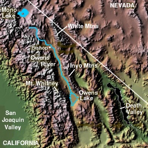
Owens Valley is the arid valley of the Owens River
in eastern California
in the United States
, to the east of the Sierra Nevada and west of the White Mountains
and Inyo Mountains
on the west edge of the Great Basin section
. The mountain peaks on either side (including Mount Whitney
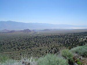
) reach above 14000 feet (4,267.2 m) in elevation, while the floor of the Owens Valley is at 4000 feet (1,219.2 m), making the valley one of the deepest in the United States. The Sierra Nevada casts the valley in a rain shadow
, which makes Owens Valley "the Land of Little Rain." The bed of Owens Lake
, now a predominantly dry endorheic alkali flat, sits on the southern end of the valley.
The valley provides water to the Los Angeles Aqueduct
, the source of half of the water for Los Angeles
, and is infamous as the scene of one of the fiercest and longest running episodes of the California Water Wars
. These episodes inspired aspects of the film Chinatown.
Towns in the Owens Valley include Bishop
, Lone Pine
, Independence
and Big Pine
. The major road in the valley is U.S. Route 395.
and the White Mountains Fault systems became active with repeated episodes of slip earthquake
s gradually producing the impressive relief of the eastern Sierra Nevada and White Mountain escarpment
s that bound the northern Owens Valley-Mono Basin
region.
Owens Valley is a graben
—a downdropped block of land between two vertical faults. Owens Valley is the westernmost graben in the Basin and Range Province. It is also part of a trough which extends from Oregon to Death Valley called the Walker Lane
.
The western flank of much of the valley has large moraine
s coming off the Sierra Nevada. These unsorted piles of rock, boulders, and dust were bulldozed to where they are by glacier
s during the last ice age
. An excellent example of a moraine is on State Route 168
as it climbs into Buttermilk Country.
This graben was formed by a long series of earthquakes, such as the 1872 Lone Pine earthquake
, that have moved the graben down and helped move the Sierra Nevada up. The graben is in fact much larger than the depth of the valley suggests; gravity studies suggest that 10000 feet (3,048 m) of sedimentary rock
mostly fills the graben and that a very steep escarpment
is buried under the western length of the valley. The topmost part of this escarpment is exposed at Alabama Hills
.
See also: Inyo and Mono Craters. Smaller versions of the Devils Postpile
, can be found, for example, by Little Lake
.
habitat. One of these, the Owens Valley checkerbloom
(Sidalcea covillei), is endemic to Owens Valley.
(also called Panamint or Koso) in the extreme south end around Owens Lake
and by the Mono tribe
(also called Owens Valley Paiute
) in the central and northern portions of the valley. The Timbisha speak the Timbisha language
, classified in the Numic branch
of Uto-Aztecan
language family
. The closest related languages are Shoshoni and Comanche
. The Eastern Mono speak a dialect of the Mono language which is also Numic, but is more closely related to Northern Paiute
. The Timbisha presently live in Death Valley
at Furnace Creek
although most families also have summer homes in the Lone Pine
colony. The Eastern Mono live in several colonies from Lone Pine to Bishop
. Trade between Native Americans of the Owens Valley between coastal tribes such as the Chumash has been indicated by the archaeological record.
In 1845, John C. Fremont
named the Owens valley, river and lake for Richard Owens, one of his guides. Camp Independence
was established on Oak Creek nearby modern Independence, California
, on July 4, 1862, during the Owens Valley Indian War
.
From 1942 to 1945 during World War II
, the first Japanese American Internment
camp operated in the valley at Manzanar
near Independence, California
.
, superintendent of the Los Angeles Department of Water and Power
(LADWP) planned the 223 miles (359 km) Los Angeles Aqueduct
, completed in 1913, which diverted water from the Owens River. Much of the water rights were acquired through subterfuge, with purchases splitting water cooperatives and pitting neighbors against each other. The purchases led to anger among local farmers, which erupted in violence in 1924, when parts of the water system were sabotaged by local farmers.
Eventually Los Angeles acquired a large fraction of the water rights to over 300,000 ac (100,000 ha) of land in the valley such that inflows to Owens Lake were almost completely diverted. This acquisition was made following negotiations in which Los Angeles and the Owens Valley farmers were engaged in a bilateral monopoly. By modern estimates, Los Angeles would have been willing to pay up to $8.70 per acre-foot of water. Eventually the average actual transaction price was near $4.00 per acre-foot, as the next best option was continuing to use the land for agricultural uses, which fetched a much lower price. Although this price was lower than Los Angeles' willingness to pay, the farmers of Owens Valley received a premium for their land compared to land values in neighboring counties. Also, the farmers who were steadfast the longest during the Owens Valley Transfers were able to sell their land for even higher prices than the average farmer received due to Los Angeles' willingness to settle. As a result of these acquisitions, the lake subsequently dried up completely, leaving the present alkali flat which plagues the southern valley with alkali dust storms.
In 1970, LADWP completed a second aqueduct from Owens Valley. More surface water was diverted and groundwater was pumped to feed the aqueduct. Owens Valley springs and seeps dried and disappeared, and groundwater-dependent vegetation began to die.
Years of litigation followed. In 1997, Inyo County, Los Angeles, the Owens Valley Committee, the Sierra Club, and other concerned parties signed a Memorandum of Understanding
that specified terms by which the lower Owens River would be rewatered by June 2003. LADWP missed this deadline and was sued again. Under another settlement, this time including the state of California, Los Angeles promised to rewater the lower Owens River by September 2005. As of February 2005, LADWP announced it was unlikely to meet this extended deadline. As of 2008, Los Angeles has rewatered the lower Owens River.
In July 2004, Los Angeles mayor James Hahn
proposed barring all future development on its Owens Valley holdings, by proposing a conservation easement
for all LADWP land. As of October 2004, Inyo County officials seemed to be resisting the offer of the easement, perhaps due to the prior history of mistrust over LADWP actions.
located near Westgard Pass
is one of ten dishes comprising the Very Long Baseline Array (VLBA)
.
Owens River
The Owens River is a river in southeastern California in the United States, approximately long. It drains into and through the Owens Valley, an arid basin between the eastern slope of the Sierra Nevada and the western faces of the Inyo and White Mountains. The river terminates at Owens Lake, but...
in eastern California
Eastern California
Eastern California is a term that refers to the eastern region of California, United States. It can refer to either the strip to the east of the crest of the Sierra Nevada, or to the easternmost counties of California.-Culture and history:...
in the United States
United States
The United States of America is a federal constitutional republic comprising fifty states and a federal district...
, to the east of the Sierra Nevada and west of the White Mountains
White Mountains (California)
The White Mountains of California are a triangular fault block mountain range facing the Sierra Nevada across the upper Owens Valley. They extend for approximately as a greatly elevated plateau about wide on the south, narrowing to a point at the north, with elevations generally increasing...
and Inyo Mountains
Inyo Mountains
The Inyo Mountains are a short mountain range east of the Sierra Nevada mountains in eastern California in the United States. The range separates the Owens Valley to the west with Saline Valley to the east, extending for approximately 70 mi SSE from the southern end of the White Mountains,...
on the west edge of the Great Basin section
Great Basin section
The Great Basin section is a physiographic area which extends into the Colorado River watershed on the southeast , as well as into the watersheds of the Klamath River and Sacramento River...
. The mountain peaks on either side (including Mount Whitney
Mount Whitney
Mount Whitney is the highest summit in the contiguous United States with an elevation of . It is on the boundary between California's Inyo and Tulare counties, west-northwest of the lowest point in North America at Badwater in Death Valley National Park...
) reach above 14000 feet (4,267.2 m) in elevation, while the floor of the Owens Valley is at 4000 feet (1,219.2 m), making the valley one of the deepest in the United States. The Sierra Nevada casts the valley in a rain shadow
Rain shadow
A rain shadow is a dry area on the lee side of a mountainous area. The mountains block the passage of rain-producing weather systems, casting a "shadow" of dryness behind them. As shown by the diagram to the right, the warm moist air is "pulled" by the prevailing winds over a mountain...
, which makes Owens Valley "the Land of Little Rain." The bed of Owens Lake
Owens Lake
Owens Lake is a mostly dry lake in the Owens Valley on the eastern side of the Sierra Nevada in Inyo County, California. It is located about south of Lone Pine, California...
, now a predominantly dry endorheic alkali flat, sits on the southern end of the valley.
The valley provides water to the Los Angeles Aqueduct
Los Angeles Aqueduct
The Los Angeles Aqueduct system comprising the Los Angeles Aqueduct and the Second Los Angeles Aqueduct, is a water conveyance system operated by the Los Angeles Department of Water and Power...
, the source of half of the water for Los Angeles
Los Angeles, California
Los Angeles , with a population at the 2010 United States Census of 3,792,621, is the most populous city in California, USA and the second most populous in the United States, after New York City. It has an area of , and is located in Southern California...
, and is infamous as the scene of one of the fiercest and longest running episodes of the California Water Wars
California Water Wars
The California Water Wars were a series of conflicts between the city of Los Angeles, farmers and ranchers in the Owens Valley of Eastern California, and environmentalists. As Los Angeles grew in the late 1800s, it started to outgrow its water supply. Fred Eaton, mayor of Los Angeles, realized that...
. These episodes inspired aspects of the film Chinatown.
Towns in the Owens Valley include Bishop
Bishop, California
Bishop is a city in Inyo County, California, United States. Though Bishop is the only city and the largest populated place in Inyo County, the county seat is Independence. Bishop is located near the northern end of the Owens Valley, at an elevation of 4147 feet . The population was 3,879 at the...
, Lone Pine
Lone Pine, California
Lone Pine is a census-designated place in Inyo County, California, United States. Lone Pine is located south-southeast of Independence, at an elevation of 3727 feet . The population was 2,035 at the 2010 census, up from 1,655 at the 2000 census. The town is located in the Owens Valley, near the...
, Independence
Independence, California
Independence is the county seat of Inyo County, California. Independence is located south-southeast of Bishop, at an elevation of 3930 feet . The population of this census-designated place was 669 at the 2010 census, up from 574 at the 2000 census....
and Big Pine
Big Pine, California
Big Pine is a census-designated place in Inyo County, California, United States. Big Pine is located south-southeast of Bishop, at an elevation of 3990 feet . The population was 1,756 at the 2010 census, up from 1,350 at the 2000 census...
. The major road in the valley is U.S. Route 395.
Geology
Beginning about 3 million years ago, the Sierra Nevada FaultSierra Nevada Fault
The Sierra Nevada Fault is a normal seismic fault along the eastern edge of the Sierra Nevada mountain block in California. It also demarcates the western margin of the Basin and Range geologic province. Activity on this fault is responsible for the continuing uplift of the Sierra Nevada. ...
and the White Mountains Fault systems became active with repeated episodes of slip earthquake
Earthquake
An earthquake is the result of a sudden release of energy in the Earth's crust that creates seismic waves. The seismicity, seismism or seismic activity of an area refers to the frequency, type and size of earthquakes experienced over a period of time...
s gradually producing the impressive relief of the eastern Sierra Nevada and White Mountain escarpment
Escarpment
An escarpment is a steep slope or long cliff that occurs from erosion or faulting and separates two relatively level areas of differing elevations.-Description and variants:...
s that bound the northern Owens Valley-Mono Basin
Mono Basin
The Mono Basin is an endorheic drainage basin located east of Yosemite National Park in California and Nevada. It is bordered to the west by the Sierra Nevada, to the east by the Cowtrack Mountains, to the north by the Bodie Hills, and to the south by the north ridge of the Long Valley...
region.
Owens Valley is a graben
Graben
In geology, a graben is a depressed block of land bordered by parallel faults. Graben is German for ditch. Graben is used for both the singular and plural....
—a downdropped block of land between two vertical faults. Owens Valley is the westernmost graben in the Basin and Range Province. It is also part of a trough which extends from Oregon to Death Valley called the Walker Lane
Walker Lane
The Walker Lane is a geologic trough roughly aligned with the California/Nevada border southward to where Death Valley intersects the Garlock Fault, a major left-lateral strike-slip fault...
.
The western flank of much of the valley has large moraine
Moraine
A moraine is any glacially formed accumulation of unconsolidated glacial debris which can occur in currently glaciated and formerly glaciated regions, such as those areas acted upon by a past glacial maximum. This debris may have been plucked off a valley floor as a glacier advanced or it may have...
s coming off the Sierra Nevada. These unsorted piles of rock, boulders, and dust were bulldozed to where they are by glacier
Glacier
A glacier is a large persistent body of ice that forms where the accumulation of snow exceeds its ablation over many years, often centuries. At least 0.1 km² in area and 50 m thick, but often much larger, a glacier slowly deforms and flows due to stresses induced by its weight...
s during the last ice age
Ice age
An ice age or, more precisely, glacial age, is a generic geological period of long-term reduction in the temperature of the Earth's surface and atmosphere, resulting in the presence or expansion of continental ice sheets, polar ice sheets and alpine glaciers...
. An excellent example of a moraine is on State Route 168
California State Route 168
State Route 168 is a state highway in California, USA, which is separated into three distinct segments, in part by the Sierra Nevada mountains....
as it climbs into Buttermilk Country.
This graben was formed by a long series of earthquakes, such as the 1872 Lone Pine earthquake
1872 Lone Pine earthquake
The Great Lone Pine earthquake was one of the largest earthquakes to hit California in recorded history. The quake struck on March 26, 1872 and its epicenter was near Lone Pine, California in Owens Valley...
, that have moved the graben down and helped move the Sierra Nevada up. The graben is in fact much larger than the depth of the valley suggests; gravity studies suggest that 10000 feet (3,048 m) of sedimentary rock
Sedimentary rock
Sedimentary rock are types of rock that are formed by the deposition of material at the Earth's surface and within bodies of water. Sedimentation is the collective name for processes that cause mineral and/or organic particles to settle and accumulate or minerals to precipitate from a solution....
mostly fills the graben and that a very steep escarpment
Escarpment
An escarpment is a steep slope or long cliff that occurs from erosion or faulting and separates two relatively level areas of differing elevations.-Description and variants:...
is buried under the western length of the valley. The topmost part of this escarpment is exposed at Alabama Hills
Alabama Hills
Alabama Hills are a "range of hills" and rock formations near the eastern slope of the Sierra Nevada Mountains in the Owens Valley, west of Lone Pine in Inyo County, California....
.
See also: Inyo and Mono Craters. Smaller versions of the Devils Postpile
Devils Postpile National Monument
Devils Postpile National Monument is located near Mammoth Mountain in extreme northeastern Madera County in eastern California. It was established in 1911, and protects Devils Postpile, an unusual formation of columnar basalt.-Geography:...
, can be found, for example, by Little Lake
Little Lake, Inyo County, California
Little Lake is an unincorporated community in Inyo County, California. It is located south of Keeler on U.S. Route 395 in California, at an elevation of 3130 feet ....
.
Ecology
The valley contains plants adapted to alkali flatDry lake
Dry lakes are ephemeral lakebeds, or a remnant of an endorheic lake. Such flats consist of fine-grained sediments infused with alkali salts. Dry lakes are also referred to as alkali flats, sabkhas, playas or mud flats...
habitat. One of these, the Owens Valley checkerbloom
Sidalcea covillei
Sidalcea covillei is an uncommon species of flowering plant in the mallow family known by the common name Owens Valley checkerbloom, or Owens Valley sidalcea. It is endemic to the Owens Valley of Inyo County, California, where it grows on alkali flats and in alkaline meadows and springs...
(Sidalcea covillei), is endemic to Owens Valley.
History
The valley was inhabited in late prehistoric times by the TimbishaTimbisha
The Timbisha are a Native American tribe federally recognized as the Death Valley Timbisha Shoshone Band of California. They are known as the Timbisha Shoshone Tribe and are located in south central California, near the Nevada border.-History:The Timbisha have lived in the Death Valley region of...
(also called Panamint or Koso) in the extreme south end around Owens Lake
Owens Lake
Owens Lake is a mostly dry lake in the Owens Valley on the eastern side of the Sierra Nevada in Inyo County, California. It is located about south of Lone Pine, California...
and by the Mono tribe
Mono tribe
The Mono are a Native American people who traditionally live in the central Sierra Nevada Mountains, the Eastern Sierra , the Mono Basin, and adjacent areas of the Great Basin.-Culture and geography:...
(also called Owens Valley Paiute
Paiute
Paiute refers to three closely related groups of Native Americans — the Northern Paiute of California, Idaho, Nevada and Oregon; the Owens Valley Paiute of California and Nevada; and the Southern Paiute of Arizona, southeastern California and Nevada, and Utah.-Origin of name:The origin of...
) in the central and northern portions of the valley. The Timbisha speak the Timbisha language
Timbisha language
The Timbisha language is the language of the Native American people who have inhabited the region in and around Death Valley, California and the southern Owens Valley since late prehistoric times...
, classified in the Numic branch
Numic languages
Numic is a branch of the Uto-Aztecan language family. It includes seven languages spoken by Native American peoples traditionally living in the Great Basin, Colorado River basin, and southern Great Plains. The word Numic comes from the cognate word in all Numic languages for "person." For...
of Uto-Aztecan
Uto-Aztecan languages
Uto-Aztecan or Uto-Aztekan is a Native American language family consisting of over 30 languages. Uto-Aztecan languages are found from the Great Basin of the Western United States , through western, central and southern Mexico Uto-Aztecan or Uto-Aztekan is a Native American language family...
language family
Language family
A language family is a group of languages related through descent from a common ancestor, called the proto-language of that family. The term 'family' comes from the tree model of language origination in historical linguistics, which makes use of a metaphor comparing languages to people in a...
. The closest related languages are Shoshoni and Comanche
Comanche language
Comanche is a Uto-Aztecan language spoken by the Comanche people, who split off from the Shoshone soon after they acquired horses in around 1705...
. The Eastern Mono speak a dialect of the Mono language which is also Numic, but is more closely related to Northern Paiute
Northern Paiute language
Northern Paiute is a Western Numic language of the Uto-Aztecan family, which according to Marianne Mithun had around 500 fluent speakers in 1994. Ethnologue reported the number of speakers in 1999 as 1,631...
. The Timbisha presently live in Death Valley
Death Valley
Death Valley is a desert valley located in Eastern California. Situated within the Mojave Desert, it features the lowest, driest, and hottest locations in North America. Badwater, a basin located in Death Valley, is the specific location of the lowest elevation in North America at 282 feet below...
at Furnace Creek
Furnace Creek, California
Furnace Creek is a census-designated place in Inyo County, California, United States. The population was 24 at the 2010 census, down from 31 at the 2000 census. The elevation of the village is below sea level....
although most families also have summer homes in the Lone Pine
Lone Pine, California
Lone Pine is a census-designated place in Inyo County, California, United States. Lone Pine is located south-southeast of Independence, at an elevation of 3727 feet . The population was 2,035 at the 2010 census, up from 1,655 at the 2000 census. The town is located in the Owens Valley, near the...
colony. The Eastern Mono live in several colonies from Lone Pine to Bishop
Bishop, California
Bishop is a city in Inyo County, California, United States. Though Bishop is the only city and the largest populated place in Inyo County, the county seat is Independence. Bishop is located near the northern end of the Owens Valley, at an elevation of 4147 feet . The population was 3,879 at the...
. Trade between Native Americans of the Owens Valley between coastal tribes such as the Chumash has been indicated by the archaeological record.
In 1845, John C. Fremont
John C. Frémont
John Charles Frémont , was an American military officer, explorer, and the first candidate of the anti-slavery Republican Party for the office of President of the United States. During the 1840s, that era's penny press accorded Frémont the sobriquet The Pathfinder...
named the Owens valley, river and lake for Richard Owens, one of his guides. Camp Independence
Fort Independence (California)
Fort Independence, originally Camp Independence, was established on Oak Creek, north of nearby modern Independence, California on July 4, 1862 during the Owens Valley Indian War. The fort was abandoned at the end of hostilities with the Owens Valley Paiute, in December 1864. However it was...
was established on Oak Creek nearby modern Independence, California
Independence, California
Independence is the county seat of Inyo County, California. Independence is located south-southeast of Bishop, at an elevation of 3930 feet . The population of this census-designated place was 669 at the 2010 census, up from 574 at the 2000 census....
, on July 4, 1862, during the Owens Valley Indian War
Owens Valley Indian War
The Owens Valley War was fought between 1862 and 1863, by California Volunteers and local settlers against the Owens Valley Paiutes, and their Shoshone and Kawaiisu allies, in the Owens Valley of California and the southwestern Nevada border region. The removal of a large number of the Owens River...
.
From 1942 to 1945 during World War II
World War II
World War II, or the Second World War , was a global conflict lasting from 1939 to 1945, involving most of the world's nations—including all of the great powers—eventually forming two opposing military alliances: the Allies and the Axis...
, the first Japanese American Internment
Japanese American internment
Japanese-American internment was the relocation and internment by the United States government in 1942 of approximately 110,000 Japanese Americans and Japanese who lived along the Pacific coast of the United States to camps called "War Relocation Camps," in the wake of Imperial Japan's attack on...
camp operated in the valley at Manzanar
Manzanar
Manzanar is most widely known as the site of one of ten camps where over 110,000 Japanese Americans were imprisoned during World War II. Located at the foot of the Sierra Nevada in California's Owens Valley between the towns of Lone Pine to the south and Independence to the north, it is...
near Independence, California
Independence, California
Independence is the county seat of Inyo County, California. Independence is located south-southeast of Bishop, at an elevation of 3930 feet . The population of this census-designated place was 669 at the 2010 census, up from 574 at the 2000 census....
.
California Water Wars
In the early 20th century, the valley became the scene of a struggle between local residents and the city of Los Angeles over water rights. William MulhollandWilliam Mulholland
William Mulholland was the head of Los Angeles Department of Water and Power, in Los Angeles. He was responsible for building the water aqueducts and dams that allowed the city to grow into one of the largest in the world. His methods of obtaining water for the city led to disputes collectively...
, superintendent of the Los Angeles Department of Water and Power
Los Angeles Department of Water and Power
The Los Angeles Department of Water and Power is the largest municipal utility in the United States, serving over four million residents. It was founded in 1902 to supply water and electricity to residents and businesses in Los Angeles and surrounding communities...
(LADWP) planned the 223 miles (359 km) Los Angeles Aqueduct
Los Angeles Aqueduct
The Los Angeles Aqueduct system comprising the Los Angeles Aqueduct and the Second Los Angeles Aqueduct, is a water conveyance system operated by the Los Angeles Department of Water and Power...
, completed in 1913, which diverted water from the Owens River. Much of the water rights were acquired through subterfuge, with purchases splitting water cooperatives and pitting neighbors against each other. The purchases led to anger among local farmers, which erupted in violence in 1924, when parts of the water system were sabotaged by local farmers.
Eventually Los Angeles acquired a large fraction of the water rights to over 300,000 ac (100,000 ha) of land in the valley such that inflows to Owens Lake were almost completely diverted. This acquisition was made following negotiations in which Los Angeles and the Owens Valley farmers were engaged in a bilateral monopoly. By modern estimates, Los Angeles would have been willing to pay up to $8.70 per acre-foot of water. Eventually the average actual transaction price was near $4.00 per acre-foot, as the next best option was continuing to use the land for agricultural uses, which fetched a much lower price. Although this price was lower than Los Angeles' willingness to pay, the farmers of Owens Valley received a premium for their land compared to land values in neighboring counties. Also, the farmers who were steadfast the longest during the Owens Valley Transfers were able to sell their land for even higher prices than the average farmer received due to Los Angeles' willingness to settle. As a result of these acquisitions, the lake subsequently dried up completely, leaving the present alkali flat which plagues the southern valley with alkali dust storms.
In 1970, LADWP completed a second aqueduct from Owens Valley. More surface water was diverted and groundwater was pumped to feed the aqueduct. Owens Valley springs and seeps dried and disappeared, and groundwater-dependent vegetation began to die.
Years of litigation followed. In 1997, Inyo County, Los Angeles, the Owens Valley Committee, the Sierra Club, and other concerned parties signed a Memorandum of Understanding
Memorandum of understanding
A memorandum of understanding is a document describing a bilateral or multilateral agreement between parties. It expresses a convergence of will between the parties, indicating an intended common line of action. It is often used in cases where parties either do not imply a legal commitment or in...
that specified terms by which the lower Owens River would be rewatered by June 2003. LADWP missed this deadline and was sued again. Under another settlement, this time including the state of California, Los Angeles promised to rewater the lower Owens River by September 2005. As of February 2005, LADWP announced it was unlikely to meet this extended deadline. As of 2008, Los Angeles has rewatered the lower Owens River.
In July 2004, Los Angeles mayor James Hahn
James Hahn
James Kenneth "Jim" Hahn is an American politician. Hahn was elected the 40th Mayor of Los Angeles in 2001. He served until 2005, at which time he was defeated in his bid for re-election...
proposed barring all future development on its Owens Valley holdings, by proposing a conservation easement
Conservation easement
In the United States, a conservation easement is an encumbrance — sometimes including a transfer of usage rights — which creates a legally enforceable land preservation agreement between a landowner and a government agency or a qualified land...
for all LADWP land. As of October 2004, Inyo County officials seemed to be resisting the offer of the easement, perhaps due to the prior history of mistrust over LADWP actions.
Radio observatory
The Owens Valley Radio ObservatoryOwens Valley Radio Observatory
The Owens Valley Radio Observatory is a radio observatory located near Bishop, California, within the Owens Valley, California region, approximately 250 miles north of Los Angeles on the east side of the Sierra Nevada. It is owned and operated by the California Institute of Technology. For...
located near Westgard Pass
Westgard Pass
Westgard Pass is a narrow gap between the White and Inyo mountain ranges in the Basin and Range Province of California. Westgard Pass lies entirely within the Inyo National Forest, in northern Inyo County, California....
is one of ten dishes comprising the Very Long Baseline Array (VLBA)
Very Long Baseline Array
The Very Long Baseline Array is a system of ten radio telescopes controlled remotely from the Array Operations Center in Socorro, New Mexico by the National Radio Astronomy Observatory. The array works together as the world's largest dedicated, full-time astronomical instrument using the...
.
See also
- List of books about the Sierra Nevada for further reading
- Owens RiverOwens RiverThe Owens River is a river in southeastern California in the United States, approximately long. It drains into and through the Owens Valley, an arid basin between the eastern slope of the Sierra Nevada and the western faces of the Inyo and White Mountains. The river terminates at Owens Lake, but...
External links
- The Owens Valley Committee: The Owens Valley
- Cenozoic/Mesozoic Volcanism of the Eastern Sierra Nevada
- Lower Owens River Project - 60 miles (96.6 km) restoration of the lower owens river
- Inyo County Water Department
- Eval. of the Hydrologic System and Selected Water-Management Alternatives in the Owens Valley, California
- Roadside Geology and Mining History of the Owens Valley and Mono Basin