

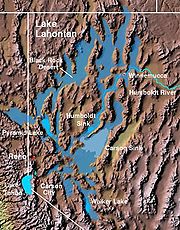
Lake Lahontan
Encyclopedia
Pleistocene
The Pleistocene is the epoch from 2,588,000 to 11,700 years BP that spans the world's recent period of repeated glaciations. The name pleistocene is derived from the Greek and ....
lake
Lake
A lake is a body of relatively still fresh or salt water of considerable size, localized in a basin, that is surrounded by land. Lakes are inland and not part of the ocean and therefore are distinct from lagoons, and are larger and deeper than ponds. Lakes can be contrasted with rivers or streams,...
of modern northwestern Nevada
Nevada
Nevada is a state in the western, mountain west, and southwestern regions of the United States. With an area of and a population of about 2.7 million, it is the 7th-largest and 35th-most populous state. Over two-thirds of Nevada's people live in the Las Vegas metropolitan area, which contains its...
that extended into northeastern California
California
California is a state located on the West Coast of the United States. It is by far the most populous U.S. state, and the third-largest by land area...
and southern Oregon
Oregon
Oregon is a state in the Pacific Northwest region of the United States. It is located on the Pacific coast, with Washington to the north, California to the south, Nevada on the southeast and Idaho to the east. The Columbia and Snake rivers delineate much of Oregon's northern and eastern...
. The area of the former lake is a large portion of the Great Basin
Great Basin
The Great Basin is the largest area of contiguous endorheic watersheds in North America and is noted for its arid conditions and Basin and Range topography that varies from the North American low point at Badwater Basin to the highest point of the contiguous United States, less than away at the...
that borders the Sacramento River
Sacramento River
The Sacramento River is an important watercourse of Northern and Central California in the United States. The largest river in California, it rises on the eastern slopes of the Klamath Mountains, and after a journey south of over , empties into Suisun Bay, an arm of the San Francisco Bay, and...
watershed to the west.
History
At its peak approximately 12,700 years ago (during a period known as the "Sehoo Highstand"), the lake had a surface area of over 8500 square miles (22,014.9 km²), with its largest component centered at the location of the present Carson SinkCarson Sink
Carson Sink is a playa in the northeastern portion of the Carson Desert that was formerly the terminus of the Carson River. The sink is currently fed by drainage canals of the Truckee-Carson Irrigation District...
. The depth of the lake was approximately 900 feet (274.3 m) at present day Pyramid Lake, and 500 feet (152.4 m) at the Black Rock Desert
Black Rock Desert
The Black Rock Desert is an arid region in the northern Nevada section of the Great Basin with a lakebed that is a dry remnant of Pleistocene Lake Lahontan...
. Lake Lahontan, during this most recent glacial period, would have been one of the largest lakes in North America
North America
North America is a continent wholly within the Northern Hemisphere and almost wholly within the Western Hemisphere. It is also considered a northern subcontinent of the Americas...
.
Climate change around the end of the Pleistocene epoch
Epoch (geology)
An epoch is a subdivision of the geologic timescale based on rock layering. In order, the higher subdivisions are periods, eras and eons. We are currently living in the Holocene epoch...
led to a gradual desiccation
Desiccation
Desiccation is the state of extreme dryness, or the process of extreme drying. A desiccant is a hygroscopic substance that induces or sustains such a state in its local vicinity in a moderately sealed container.-Science:...
of ancient Lake Lahontan. The lake had largely disappeared in its extended form by approximately 9,000 years ago. As the surface elevation dropped, the lake broke up into series of smaller lakes, most of which rapidly dried up leaving only a playa
Dry lake
Dry lakes are ephemeral lakebeds, or a remnant of an endorheic lake. Such flats consist of fine-grained sediments infused with alkali salts. Dry lakes are also referred to as alkali flats, sabkhas, playas or mud flats...
. These playas include the Black Rock Desert, the Carson Sink and the Humboldt Sink
Humboldt Sink
Humboldt Sink is an intermittent dry lake bed, approximately 11 mi long, and 4 mi across, in northwestern Nevada in the United States...
. The only modern day remnants existing as true lakes are Pyramid Lake and Walker Lake
Walker Lake (Nevada)
Walker Lake is a natural lake, 50.3 mi² in area, in the Great Basin in western Nevada in the United States. It is 18 mi long and 7 mi wide, located in northwestern Mineral County along the eastern side of the Wassuk Range, approximately 75 mi southeast of Reno...
. Winnemucca Lake
Winnemucca Lake
Winnemucca Lake, just east of Pyramid Lake in the northwestern portion of the U.S. state of Nevada is on the dividing line between Washoe County and Pershing County counties.- Geography :...
has been dry since the 1930s and Honey Lake
Honey Lake
Honey Lake is an endorheic sink within the Honey Lake Valley located in northeastern California, near the Nevada border. Summer evaporation reduces the lake to a lower level of 12 km² and creates an alkali flat....
periodically desiccates. The ancient shoreline is evidenced by tufa
Tufa
Tufa is a variety of limestone, formed by the precipitation of carbonate minerals from ambient temperature water bodies. Geothermally heated hot-springs sometimes produce similar carbonate deposits known as travertine...
formations throughout the area.
Surprisingly, the watershed feeding Lake Lahontan is not thought to have been significantly wetter during its highstand than it is currently. Rather, its desiccation is thought to be mostly due to increase in the evaporation
Evaporation
Evaporation is a type of vaporization of a liquid that occurs only on the surface of a liquid. The other type of vaporization is boiling, which, instead, occurs on the entire mass of the liquid....
rate as the climate warmed. Recent computer simulations (using the DSSAM Model
DSSAM Model
The DSSAM Model is a computer simulation developed for the Truckee River to analyze water quality impacts from land use and wastewater management decisions in the Truckee River Basin. This area includes the cities of Reno and Sparks, Nevada as well as the Lake Tahoe Basin...
and other techniques) indicate that if precipitation and evaporation rates within the watershed were maintained at their historical yearly maximum and minimum, respectively and if diversions of the Truckee River
Truckee River
The Truckee River is a stream in the U.S. states of California and Nevada. The river is about long. Its endorheic drainage basin is about , of which about are in Nevada. The Truckee is the sole outlet of Lake Tahoe and drains part of the high Sierra Nevada, emptying into Pyramid Lake in the Great...
ceased, the Ice Age extent of Lake Lahontan might return.
Archaeological evidence along the shore indicates the existence of the lake coincided roughly with the first appearance of humans in the region. The Lahontan cutthroat trout
Lahontan cutthroat trout
Lahontan cutthroat trout is the largest subspecies of cutthroat trout, and the state fish of Nevada.-Natural history:...
evolved as a predator species within the waters of Lake Lahontan, feeding on native chub
Tui chub
The Tui chub, Gila bicolor, is a cyprinid fish native to western North America. Widespread in many areas, it is an important food source for other fish, including the cutthroat trout.- Range :...
and sucker
Catostomidae
Catostomidae is the sucker family of the order Cypriniformes. There are 80 species in this family of freshwater fishes. Catostomidae are found in North America, east central China, and eastern Siberia...
. This subspecies of cutthroat trout
Cutthroat trout
The cutthroat trout is a species of freshwater fish in the salmon family of order Salmoniformes. It is one of the many fish species colloquially known as trout...
survives today in tributary rivers of the Great Basin
Great Basin
The Great Basin is the largest area of contiguous endorheic watersheds in North America and is noted for its arid conditions and Basin and Range topography that varies from the North American low point at Badwater Basin to the highest point of the contiguous United States, less than away at the...
, and has been re-introduced to Pyramid Lake and Walker Lake after being extirpated
Local extinction
Local extinction, also known as extirpation, is the condition of a species which ceases to exist in the chosen geographic area of study, though it still exists elsewhere...
during the 20th century.